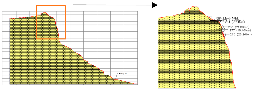
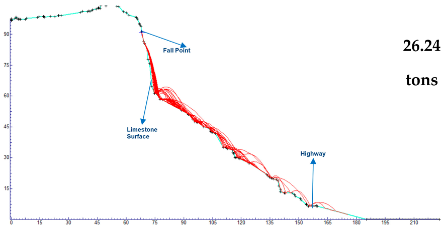
Abstract
This study presents a digital twin–based framework for assessing rockfall hazards at the immediate vicinity of the Rumkale Archaeological Site, a geologically sensitive and culturally significant location in southeastern Türkiye. Historically associated with early Christianity and strategically located along the Euphrates, Rumkale is a protected heritage site that attracts increasing numbers of visitors. Here, high-resolution photogrammetric models were generated using imagery acquired from a remotely piloted aircraft system and post-processed with ground control points to produce a spatially accurate 3D digital twin. Field-based geomechanical measurements including discontinuity orientations, joint classifications, and strength parameters were integrated with digital analyses to identify and evaluate hazardous rock blocks. Kinematic assessments conducted in the study revealed susceptibility to planar, wedge, and toppling failures. The results showed the role of lithological structure, active tectonics, and environmental factors in driving slope instability. The proposed methodology demonstrates effective use of digital twin technologies in conjunction with traditional geotechnical techniques, offering a replicable and non-invasive approach for site-scale hazard evaluation and conservation planning in heritage contexts. This work contributes to the advancement of interdisciplinary methods for geohazard-informed management of cultural landscapes.
1. Introduction
Rumkale, a dramatic ancient fortress situated along the Euphrates in southeastern Türkiye, has gained renewed attention in recent decades, particularly following the construction of the Birecik Dam in 2000 [1,2]. As the rising waters flooded vast portions of the Euphrates Valley, numerous archeological sites, including the renowned Roman city of Zeugma, were submerged. Amid this transformation, Rumkale now stands as a peninsula projecting into the artificial lake and is accessible solely by boat. Often associated with early Christian narratives, the site is reputed to have been the place where St. John the Apostle wrote part of the New Testament. Due to its strategic location, it has been known by various names throughout history, including Šitamrat, Kal-a Rhomayta, Hromklay, Ranculat, Kal-at el Rum, Kal-at el Müslimin, and Kale-i Zerrin. While its recent fame has attracted increasing numbers of visitors, the fortress remains vulnerable to erosion due to the soft, lime-rich soil beneath it, and many of its historical features are now underwater [3]. In response to the transformation of the Euphrates Valley into a reservoir, authorities and local communities have implemented conservation measures around Rumkale by restricting access within 300 m of the lakeshore and managing both sides of the lake to mitigate environmental impacts and promote sustainable development [4].
Rumkale is situated atop steep cliffs overlooking the Euphrates River, within a region characterized by Miocene limestones interbedded with marl and claystone. These soft, carbonate-rich sediments are relatively weak and prone to weathering, particularly when exposed to water. The area is part of the tectonically active Southeastern Anatolia zone, where fault systems and neotectonic activity have shaped both the topography and the stability of the slopes. The geomorphology of the site, marked by sharp escarpments, rock outcrops, and karstic features, reflects both erosional processes and tectonic uplift. This geological composition plays a critical role in the vulnerability of the site to slope failures and rockfalls.
Rockfalls are among the most common and hazardous types of slope failures in steep, fractured terrains, and pose significant threats to infrastructure, human life, and cultural heritage sites. They typically involve the detachment and downslope movement of rock masses by free fall, bouncing, or rolling [5,6]. Although their spatial extent is usually small compared to other geohazards, their sudden nature and high energy release can cause serious damage, especially in sites frequented by visitors or containing historical structures [7,8].
The observation deck in the immediate vicinity of Rumkale is located on a cliff. This deck is used by visitors seeking to view and photograph Rumkale. In addition, a boat pier is located at the toe of the cliff to facilitate visitor access to Rumkale. The only access point to Rumkale is located at the base of the cliff, directly across from the fortress. During the earthquakes of 6 February 2023, numerous rockfalls and landslides occurred on a regional scale [9]. Seismic loading has a significant influence on the behavior of discontinuities within rock masses and plays a key role in the initiation of rockfalls. Even low-magnitude earthquakes and slopes with relatively moderate inclinations can trigger rockfall events [10]. Dynamic stresses generated by seismic waves may lead to the dilation or propagation of existing joints and cracks. Previous studies have shown that seismic energy can cause joint opening or shear displacement, which reduces the interlocking between blocks and decreases overall slope stability [11]. This mechanism becomes particularly critical in steep slopes that are heavily jointed, where earthquake-induced joint expansion increases the likelihood of block detachment. In most simulation-based studies, the initiation of rockfall under seismic conditions is modeled by assuming near-zero initial velocity at the point of detachment, allowing the block to undergo free fall [12]. The resulting trajectory and final stopping point are essential for assessing potential hazard zones. The 6 February 2023 Earthquakes triggered rockfalls from the cliff supporting the observation deck, and the shops at the toe of the cliff and the pier area were affected. Therefore, assessing the rockfall hazard on the cliff, a key area frequented by visitors, is crucial for ensuring public safety. The limestone bedrock, while initially compact, exhibits significant fracturing and jointing, which reduces slope cohesion and increases the potential for rockfalls and mass movements, particularly along the cliff faces. The prolonged submersion of lower slopes following the construction of the Birecik Dam has also accelerated erosion at the slope toe and groundwater infiltration, further destabilizing the cliff base. Seasonal fluctuations in water level, rainfall, and seismic activity may contribute to progressive slope instability, posing significant safety risks to visitors.
Although there is a growing body of research on digital twin applications for documenting, modeling, and assessing cultural heritage, interdisciplinary approaches integrating photogrammetric digital twin models with geotechnical analysis and natural hazard assessments remain underrepresented in the literature. Studies focusing on site-scale risks such as rockfalls, slope instability, and erosion using digital twins as analytical and monitoring tools are still relatively scarce. Numerous recent studies have explored the integration of digital twin technologies with cultural heritage applications, particularly in the context of documentation and digital asset management [13,14]. However, these studies do not address georisk-related factors, such as slope instability or rockfall hazards. On the other hand, the literature focusing on the use of digital twins for geohazard assessment and modeling is growing [15] without addressing the preservation of cultural heritage. This highlights a critical research gap and the need for comprehensive frameworks merging geomatics, geotechnics, and heritage conservation to inform risk management at vulnerable cultural heritage sites.
Considering these challenges, this study aimed to integrate photogrammetric three-dimensional (3D) modeling with geotechnical assessments within a digital twin framework for cultural heritage preservation in Türkiye. High-resolution digital replicas of the immediate vicinity of Rumkale were generated and linked with rockfall analyses. A remotely piloted aircraft system (RPAS) complemented by ground-based acquisitions was utilized to produce a detailed multi-view digital twin. Thus, the study aimed to monitor, simulate, and predict rockfall hazards in a non-invasive, repeatable, and spatially accurate manner. It proposes a novel and reliable methodology for managing risks at geohazard-prone historical sites. The framework provides an improved understanding of current geohazards and supports planning for site protection and sustainable accessibility.
2. Materials and Methods
A rockfall is a rapid-to-extremely rapid downslope movement involving a newly detached mass, typically from bedrock, that descends through the air by free fall, leaping, bounding, or rolling, along a surface with minimal shear displacement. It is often initiated by smaller precursor displacements [5]. A rockfall hazard results from two main processes: a rock volume breaking away from the upper slope (local slope failure) and the movement of this rock down the slope [16]. Although rockfalls may not have the same economic impact as large-scale failures that can block major roads for long periods, the number of fatalities they cause is comparable to other types of rock slope failures [17]. Rockfalls occur when one or more rock masses detach from bedrock along natural fractures and descend by falling, bouncing, rolling, or sliding, typically as individual bodies traveling at speeds of a few to several tens of meters per second. Rockfalls vary in size from small fragments to massive boulders and occur as primary events or be delayed due to secondary triggers such as rainfall, snowmelt, or freeze–thaw cycles [18]. Rockfall simulation models range from simple empirical approaches to advanced process-based models. When integrated with Geographic Information Systems (GIS), these models show strong potential for regional applications, including source area identification, path mapping, and velocity-based runout estimation. Accurate terrain characterization remains essential for improving these models and expanding their applicability beyond site-specific studies [19].
2.1. Rumkale Site Characteristics
The Rumkale Archaeological Site and its close vicinity are located within the Yavuzeli district of Gaziantep Province in southeastern Türkiye (Figure 1), in a region characterized by steep rocky terrain and complex geomorphology. The site is located where the Merzimen Stream meets the Euphrates River, forming a peninsula as a result of the Birecik Dam reservoir. This reservoir has significantly altered the local topography and slope dynamics. Rumkale is accessible only by boat and serves as a prominent cultural and tourist destination. As tourism has intensified, human activity has expanded into areas with known geohazards. Several roads and pedestrian pathways near the site traverse steep terrain and are especially susceptible to rockfall events, particularly during periods of intense or prolonged rainfall.
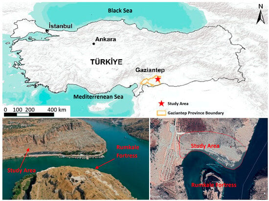
Figure 1.
(Up): location map; (lower left): photos from the project area; (lower right): satellite image of the study area.
The terrain consists of highly fractured carbonate rocks, with cliffs reaching heights of up to 70 m (see Figure 2). Rockfalls occur naturally due to gravitational instability, progressive weathering, and the presence of discontinuities such as joints and bedding planes formed by tectonic activity and long-term environmental exposure. Seasonal rainfall, temperature fluctuations, and the submersion of lower slopes by the reservoir contribute to accelerated degradation and block detachment. Additionally, karstic processes, such as dissolution cavities and voids, further reduce the mechanical stability of the rock mass, increasing the likelihood of toppling and sliding failures.
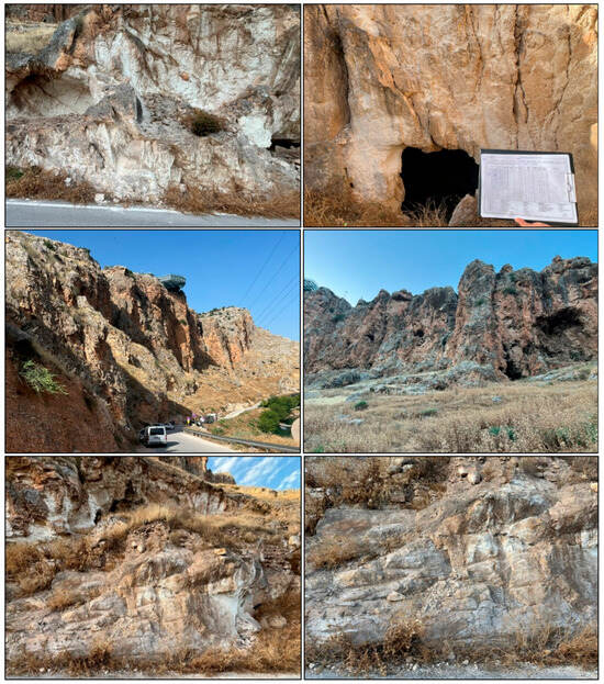
Figure 2.
Limestone structures in the close vicinity of the Rumkale historical area.
Geologically, Rumkale lies within the Gaziantep Formation, a stratigraphic unit extensively documented in southeastern Türkiye (see Figure 3). First described by Wilson and Krummenacher [20], this formation comprises a vertically stacked sequence of limestones ranging in color from white to cream and characterized by silty, chalky, and cherty textures. The lower sections consist of thin- to medium-bedded, sparsely fossiliferous chalky limestones interbedded with abundant chert nodules, clay-rich layers, and chert intercalations. Toward the top, the lithology transitions into medium- to thick-bedded, fossil-rich and algal limestones, followed by carbonate-cemented chalky calcarenites and occasional marl layers. The uppermost portion contains clayey, flint-bearing limestones that grade into the overlying Fırat Formation. The Gaziantep Formation is dated to the Upper Lutetian–Stampian interval and represents a regressive carbonate sequence deposited in a relatively open marine shelf. The alternating lithologies and mechanical contrasts within the unit contribute to its susceptibility to deformation and slope instability under both static and dynamic loading conditions.
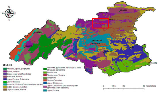
Figure 3.
Lithological units in Gaziantep Province [21].
Tectonically, Gaziantep Province lies at the convergence of the Arabian, African, and Eurasian plates, forming part of one of the most seismically active region in Türkiye. According to De Righi and Cortesini [22], the area falls within the overlapping zones of the Taurus Orogenic Belt and the Marginal Fold Belt. The current neotectonic regime is dominated by the East Anatolian Fault (EAF), a major left-lateral strike-slip fault accommodating the westward motion of the Anatolian Plate driven by the northward advance of the Arabian Plate. As a result, southeastern Türkiye experiences active crustal deformation and frequent seismic events. Numerous fault segments of varying orientations—NE–SW, NW–SE, and E–W—intersect the region, producing a complex network of folds, thrusts, and strike-slip structures [23]. Faults trending NE–SW are typically left-lateral strike-slip, those aligned NW–SE are right-lateral strike-slip, and E–W structures are predominantly associated with folding and thrusting. These tectonic patterns are also influenced by broader geodynamic processes, such as the back-arc extension south of Crete described by the Karig model, which exerts traction on the North Anatolian Fault (NAF) system.
The Rumkale site is located approximately 2.0 km from the nearest mapped fault segment, placing it within a zone of moderate-to-high seismic hazard. In addition to major fault lines, numerous secondary faults and fractures are present in the region. The combination of tectonic stresses and lithological variability contributes to the deformation of the neritic limestone units that dominate the area. These limestones show signs of both tectonic disruption and environmental weathering. Seasonal rainfall and temperature changes exacerbate the development of discontinuities, while karstic activity introduces further weakening, increasing the region’s susceptibility to rockfall.
2.2. Digital Twin Application
The concept of a “digital twin” originated with National Aeronautics and Space Administration (NASA), USA, during the 1960s Apollo missions, where digital components were integrated with physical spacecraft models to analyze failures in real time and support decision-making [24]. Today, the concept is growing rapidly, with advancements seen across many fields [25]. The number of publications on digital twins has also risen significantly in recent years. Since 2019, more than 1000 papers have been published annually, reaching 2934 publications in 2021. Furthermore, digital twins were named one of the top 10 strategic technology trends by Gartner for three years in a row from 2017 to 2019 [26]. Since the early 2000s, the use of photorealistic modeling for creating digital twins of heritage sites has increased significantly, driven by the availability of low-cost off-the-shelf cameras and photogrammetric 3D modeling software. Over time, the tools and methods for the integrated use of multi-platform (e.g., terrestrial, drone, satellite) and multi-sensor (e.g., Light Detection and Ranging—LiDAR, multispectral, thermal) data have advanced significantly and enabled creation of multi-temporal digital twins of heritage sites.
Funari et al. [27] proposed a parametric Scan-to-FEM workflow for historic masonry structures using a visual programming environment and automated Python scripts to improve modeling efficiency. Designed for buildings with modular repetition and symmetry, the method enables fast conversion of point cloud data into FE models. Applied to a Portuguese heritage monument, the model was calibrated with modal frequencies from field data to evaluate retrofitting effectiveness. Robiati et al. [15] used digital twin models to monitor and assess rockfalls at the Poggio Baldi scarp. By analyzing 3D point clouds and high-resolution orthomosaics, they identified fracture patterns and calculated block volumes. Multi-temporal surveys revealed active rockfall zones and material accumulation areas.
Kong and Hucks [28] discussed that despite advances in computer vision- and photogrammetry-based structural health monitoring (SHM) methods, there remains a research gap in developing low-cost approaches that can effectively track and correlate time-varying damage in historic structures across multiple inspections. Rocca et al. [29] presented a multidisciplinary methodology for assessing the seismic vulnerability of monumental façades and their artistic elements through the creation of a Historical Digital Twin. They integrated advanced surveying, 3D modeling, and finite element analysis to simulate structural responses under seismic loads. A case study of a Venetian façade was used to demonstrate the method, focusing on two statues positioned at different heights. The study evaluated the localized seismic effects and compared different assessment methods. The authors [29] also emphasized the critical role of historical digital twins, not only in depicting the current visible condition of heritage structures but also in serving as a repository of key information essential for ongoing monitoring and preventive conservation measures.
Alongside the advancement of RPAS platforms, recent developments in sensor technology, when combined with photogrammetric techniques, modern computing hardware, and software have made it possible to generate 3D object models. The acquisition of stereo images of surface features by RPASs significantly accelerates the data collection phase required for photogrammetric processing. In recent years, photogrammetric methods have been widely applied in geoscience studies [30,31,32]. In this study as well, a 3D model and point cloud were generated from overlapping RPAS images using photogrammetric techniques.
As part of this study, ground control point (GCP) establishment and image acquisition were carried out using a RPAS platform on 12–13 June 2024 in nadir and oblique acquisition modes. A total of 2872 overlapping images with mean ground sampling distances of 1.2 cm were captured in the field using a Phase One iXM-100 camera with Red-Green-Blue (RGB) bands [33] mounted on a Matrice 300 Real Time Kinematics (RTK) RPAS equipped with a three-axis gimbal [34]. Technical specifications of the RPAS platform are presented in Table 1.

Table 1.
The main features of the data acquisition platform and the camera.
Figure 4 illustrates the camera positions and the number of overlapping images. The color-coded legend on the right side of the figure indicates the number of image measurements per point.
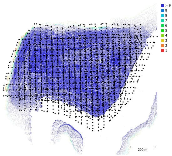
Figure 4.
Image acquisition locations and the number of image measurements per point.
To georeference the 3D model generated from the RPAS imagery and ensure absolute orientation in map coordinates, 7 GCPs measured using a Global Navigation Satellite System (GNSS) receiver via the Network RTK method were employed (Figure 5). The coordinate values of the GCPs were recorded in the Turkish National Reference Frame (TUREF)/Transvers Mercator Zone 36 (TM36) coordinate system (European Petroleum Survey Group Code: 5256). For image processing, Agisoft Metashape Professional, Agisoft LLC, St. Petersburg, Russia was used [35]. Out of seven, two GCPs were utilized as check points (CPs) to evaluate the model coordinate accuracy. The discrepancies between the ground coordinates measured with GNSS and those derived from the bundle block adjustment are presented in Table 2 for GCPs and Table 3 for CPs together with the root mean square error (RMSE) values obtained from them. Planimetric errors, computed in the pixel coordinate system, are also reported in both tables. As shown in Figure 5, the GCPs adequately cover the spatial extent of the site in both planimetry and height, while the two check points are located within the site at two distinct heights (near the upper and lower parts of the terrain).
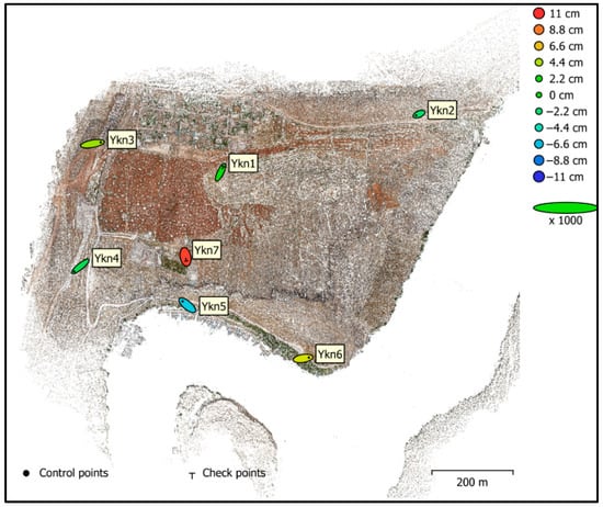
Figure 5.
The locations of the GCPs (Ykn 2–6) and CPs (Ykn1 and YKN7), and their point positioning accuracy after the bundle block adjustment.

Table 2.
The coordinate discrepancies and the RMSE values derived from the GCPs. GE: Error in Ground Coordinates; PE: Error in Pixel Coordinate System.

Table 3.
The coordinate discrepancies and the RMSE values derived from the CPs. GE: Error in Ground Coordinates; PE: Error in Pixel Coordinate System.
2.3. Rockfall Hazard Assessments
The mechanics of rockfall initiation are influenced by both geological structure and environmental factors. Discontinuities such as joints, bedding planes, and faults control the detachment of rock blocks, while triggers include seismic activity, weathering, freeze–thaw cycles, and subaerial processes. In the Rumkale region, the fractured and karstified Miocene-aged limestone, intersected by multiple joint sets, creates favorable conditions for various types of failures, including planar, wedge, and toppling mechanisms. Steep and weathered limestone slopes dominate the terrain and are visibly affected by surface deformation and past rockfall activity.
To characterize the rockfall risk at close vicinity of Rumkale, detailed engineering geological investigations were conducted. Discontinuity orientations were measured using compass and clinometer, and the orientations were analyzed through stereographic projection (Figure 6). Based on the classification by Palmström [36], joint volume measurements (Jv) were used to determine the typical block sizes in five surveyed locations (Table 4). Most areas consist of medium-sized blocks (Jv~3–5 joints/m3), with occasional large blocks in less fractured zones. Jv values were used to identify the discontinuity trends within the rock mass and to estimate typical block sizes. The locations where the field surveys were conducted are presented in Figure 7. The block sizes and associated discontinuity data used in the calculations were obtained directly from the digital twin model, where all geometries were determined at their actual scale.

Figure 6.
(a): typical rock joints with three discontinuity sets [37]; (b): rock joint curves in area; (c): Schmidt hammer used in the field studies.

Table 4.
Block size classes obtained from the line surveys based on the classification by [36].
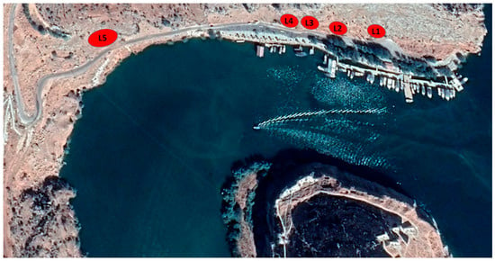
Figure 7.
Scan-line survey locations.
Shear strength parameters of the discontinuity surfaces were determined from the field survey data. Joint Roughness Coefficient (JRC) is a dimensionless parameter used to quantify the surface roughness of rock discontinuities. It typically ranges from 0 to 20, with higher values indicating greater surface roughness and interlocking potential. As the JRC increases, the shear resistance along the joint plane generally becomes more significant due to enhanced mechanical interlocking. Joint Wall Compressive Strength (JCS) represents the compressive strength of discontinuity surfaces, which play a primary role in controlling the strength and deformation characteristics of the rock mass. Since joint surfaces are typically weaker than the intact rock, accurate estimation of JCS is critical for reliable shear strength assessment. In this study, JCS values were determined using Schmidt hammer rebound measurements, based on the empirical correlation proposed by Deere and Miller [38]. Joint Roughness Coefficient (JRC) and Joint Wall Compressive Strength (JCS) values were incorporated into the empirical shear strength equation proposed by Barton [39]:
where τ is the shear strength, σₙ is the normal stress, and Φb is the basic friction angle, taken as 32° based on field conditions. JRC was assumed as 11, and JCS was estimated as 65 MPa (Megapascal). These parameters provided input for assessing failure potential at each site.
3. Results
Regarding the point positioning accuracy of the digital twin of the area, the average RMSE obtained from the check points was 8 cm. The digital twin model contains a total of 45,851,608 surfaces. As shown in Figure 8, the model is highly detailed, capturing both the top view and the vertical facades of the site comprehensively.
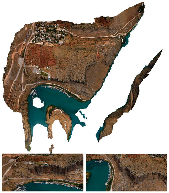
Figure 8.
Views from the digital twin model demonstrating its high density and completeness, including both top-down coverage and vertical facades of the site.
The high-resolution digital twin models generated from RPAS-based photogrammetry enabled 3D mapping of discontinuities and rockfall source areas. Using the digital geological model, the orientations of hazardous blocks were extracted and compared with field-based measurements to validate observed slope instability trends. In order to determine the geometry and spatial distribution of discontinuities, various analyses were conducted. As shown in Figure 9, individual rock blocks were color-coded based on their orientation, providing a clear visualization of both block-scale structure and discontinuity patterns on the mesh model. This representation supports the interpretation of spatial data and provide input for the kinematic analyses. In Figure 10, the potentially unstable rock masses are visualized on the RGB color-coded digital twin model, which contains over 45 million surfaces and enables spatially accurate analysis and visualization.

Figure 9.
A mesh representation of the digital twin model showing the orientation of individual rock blocks formed by discontinuities.
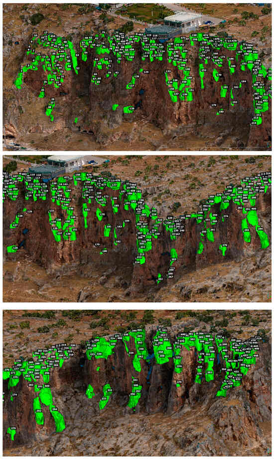
Figure 10.
Potentially unstable rock masses visualized on the RGB color-coded digital twin model.
Kinematic analyses conducted at the five representative locations (labeled in Figure 7) revealed the presence of all major rockfall mechanisms: planar sliding, wedge failure, and toppling. As an example, the kinematic analysis results for Location L1 are presented in Figure 11. Contour plots (dip/dip direction) derived from both field and model data confirmed the alignment of joint sets with slope faces, indicating high susceptibility. These findings support the observed deformation patterns and validate the need for continuous monitoring and hazard mitigation.
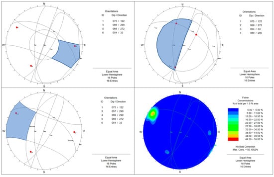
Figure 11.
Kinematic analysis results of the location L1 (see Figure 7 for this location).
The identification of hazardous rock blocks was carried out by combining field observations with kinematic analyses supported by digital twin modeling. Through this integrated approach, a total of 508 distinct rock masses were identified. These blocks vary in elevation and volume, and each exhibits at least one of the following failure mechanisms: planar sliding, wedge failure, or toppling. The topographic elevation of the site varies between 438 m and 540 m. Notably, 55% of the identified rockfall-prone blocks are located between elevations of 470 m and 498 m. Within this elevation range, the slope geometry is severely steep—in some areas nearly vertical, and in others even forming overhangs. Combined with the increased number of discontinuities observed at these levels, this makes the 470–498 m zone significantly more susceptible to rockfall activity compared to other elevations of the slope.
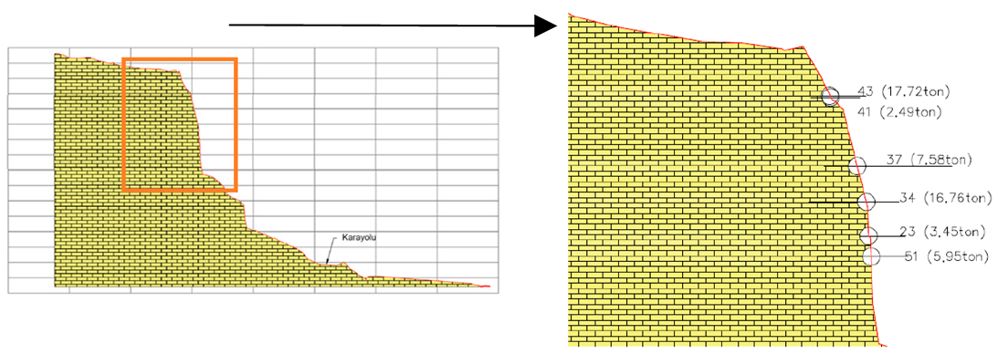
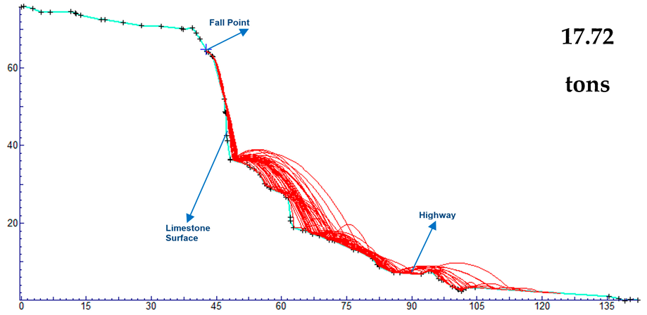
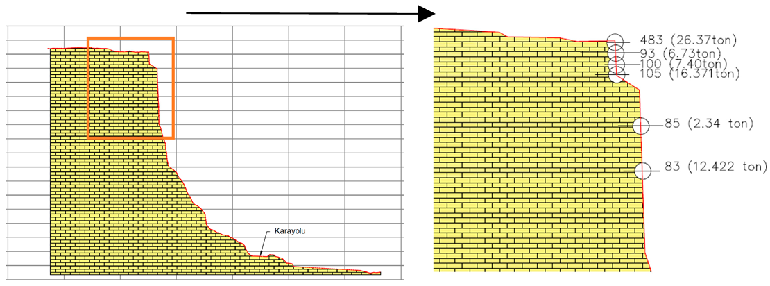
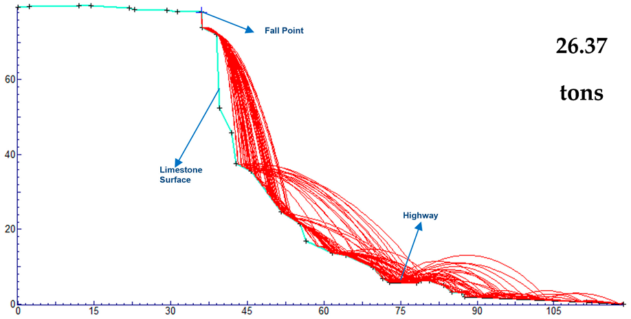
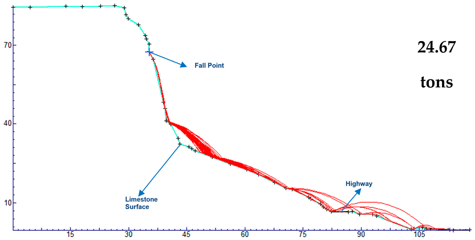
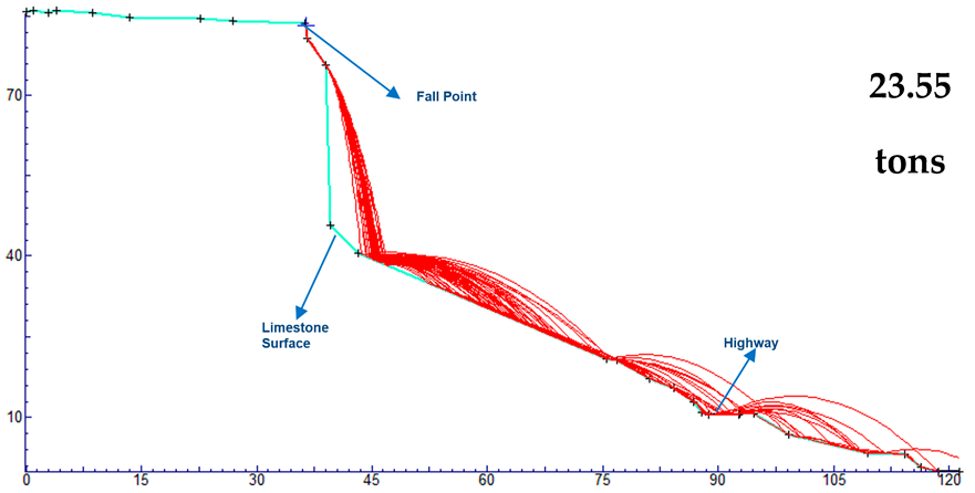
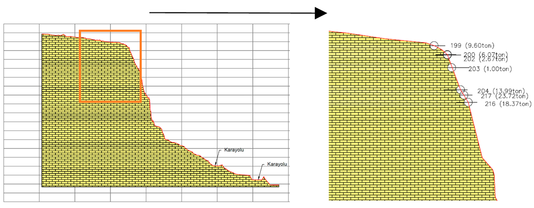
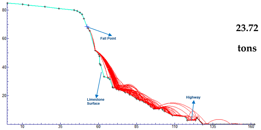
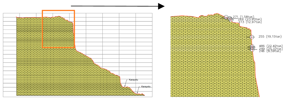
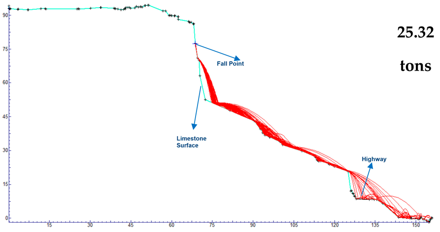
Following the identification of potentially unstable rock blocks, hazard scenarios were developed based on the existing site conditions. Accordingly, rockfall hazard was analyzed using two-dimensional analytical method. Once the geologically and topographically most critical rock masses were identified, their potential impact areas were assessed through these analyses. As a result, probable damage zones and high-risk areas that may be affected by potential rockfall events were determined. These assessments were based on key indicators such as the kinetic energy of the blocks, their runout distances (rock end points), and bounce heights.
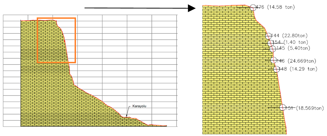
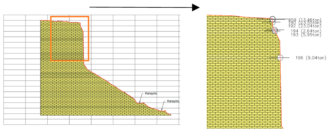
Rockfall analyses were carried out on seven representative cross-sections selected to reflect the overall conditions of the study area (Table 5). Layout of the analyzed cross-sections is presented in Figure 12. In total, 44 critical rock blocks were evaluated within these profiles. The resulting ranges of kinetic energy, rock end points, and bounce heights for each section, along with a summary of the two-dimensional analyses, are presented in Table 6. For each section, the minimum and maximum values of kinetic energy, runout distances (rock end points), and bounce heights are presented. In addition, the range of mass values identified in each section, along with their corresponding elevations, are also provided.

Table 5.
Rockfall analysis results for geological sections.
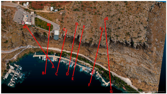
Figure 12.
Layout of the analyzed cross-sections given in Table 5.

Table 6.
Summary of 2D analyses with kinetic energy, rock end points, and bounce heights.
The cross-sections presented in Table 5 were generated for the areas identified as critical in terms of rockfall hazard. These sections were aligned to intersect both the highway and the rock discontinuities perpendicularly. Additionally, segments containing the largest potentially unstable blocks—identified through the digital twin model—were prioritized. Rockfall analyses were then performed along these sections using the determined limestone material properties.
To evaluate the motion of falling rock blocks, their interactions with the slope surface are characterized by normal and tangential restitution coefficients. Sliding behavior is governed by the friction coefficient and the friction angle [40].
In this study, the selected normal and tangential restitution coefficients for limestone are 0.315 and 0.712, respectively, as recommended in the literature and commonly used in rockfall analysis applications [41]. These values are based on field tests conducted in a limestone quarry, specifically on restoration-blasting slopes. The normal restitution coefficient was determined with a standard deviation of 0.064, while the tangential restitution coefficient had a standard deviation of 0.116. These restitution coefficients were derived from experiments performed on four distinct surface types: blast-generated rock fragments, partially vegetated scree on berms, uncovered blast piles, and vegetated quarry waste. The friction angle was selected as 30 degrees, based on the site-specific calculations. For each block on the cross-sections, initial detachment conditions were defined, and simulations were performed along 50 different potential fall trajectories per block.
As a result of the rockfall analyses, data on rock end points, bounce heights, and kinetic energy were obtained. The main parameters influencing these outcomes are the block’s initial height, mass, and failure mechanism. Kinetic energy is directly related to mass and indirectly related to height based on the principle of energy conservation. Bounce height tends to decrease with increasing block mass, while rock end points are largely governed by the initial height of the block. All these parameters act as dependent variables affecting the analysis results.
4. Discussions and Conclusions
In this study, we presented a multidisciplinary approach for assessing rockfall hazards at the close vicinity of the Rumkale Archaeological Site, a culturally significant and geologically vulnerable location in southeastern Türkiye. The study demonstrated the effectiveness of integrating digital twin technology with geotechnical analyses to assess rockfall hazards at the Rumkale Archaeological Site. The high-resolution digital twin was generated through RPAS-based photogrammetry with nadir and oblique imaging. The accuracy of the digital twin is of the order of a few centimeters, which is sufficient for the study purposes. Complemented by field-based measurements, the study enabled a comprehensive characterization of hazardous rock blocks and their failure mechanisms. The approach can easily be applied to the vicinity of Rumkale, where accessibility is highly constrained. Similar studies can be carried out in other cultural heritage sites vulnerable to rockfall hazard at these sites for assessment and monitoring. The key study outcomes and conclusions can be summarized as follows:
- The kinematic analyses performed in this study revealed a clear susceptibility to planar sliding, wedge failures, and toppling, consistent with the structural conditions of the Miocene limestone and environmental stressors such as seismic activity and water infiltration. These results showed the role of geological structure and seasonal factors in driving rockfall processes, similar to previous findings in such geohazard-prone settings.
- High-resolution RPAS-based imagery and ground control data were used to generate a detailed digital twin of the site. This model enabled precise mapping of rock discontinuities, characterization of hazardous blocks, and execution of kinematic and geomechanical analyses. Field-based measurements, including joint orientations, Schmidt hammer-derived strength parameters, and block size classifications, were aligned with digital observations to evaluate rockfall likelihood.
- The methodology presented here highlights the advantages of using a digital twin approach for site-specific hazard evaluation. It offers a non-invasive, repeatable, and spatially accurate means of monitoring and analyzing slope instabilities. Moreover, it supports proactive conservation planning by identifying critical zones that require immediate attention. For rockfall assessments, however, the use of timely and high-quality data can be essential. The cost-effective, RPAS-based approach adopted in this study allows for the regular acquisition of updated datasets to support ongoing assessments and monitoring. Since the study area is predominantly bare land, the impact of vegetation on digital twin generation was negligible. In contrast, for areas with dense vegetation cover, alternative sensor technologies such as LiDAR, along with post-processing techniques like point cloud filtering, may be required to accurately model the rock masses.
- The integration of digital twin technology with traditional geotechnical methods provided a robust framework for identifying, classifying, and evaluating hazardous rock blocks. This approach presented a replicable method for site-scale rockfall risk assessment at culturally and geologically sensitive locations. Beyond its application at Rumkale, the presented methodology contributes to the growing field of digital heritage and hazard-informed site management. It showed the value of integrating geomatics, geotechnical engineering, and digital modeling for the proactive protection of heritage landscapes facing natural threats. Future studies may expand this framework by incorporating incorporate multi-temporal monitoring, predictive simulations, and mitigation planning.
- The potential hazards from falling rock blocks under the defined analysis scenarios cannot be underestimated. Both the runout distances (rock end points) and the associated energy levels must be considered. The design and placement of protective structures should be based on estimated impact energy and expected block trajectories. In order to design protective structures, the critical zones requiring protection from potential rockfall impacts are first identified—in other words, the acceptable extent of the rockfall trajectory is clearly defined. Then, the kinetic energy of the falling blocks is translated into force-based engineering parameters, which serve as the basis for selecting appropriate protection measures, such as rockfall barriers, retaining walls and other engineering structures.
Author Contributions
Conceptualization, C.G.; methodology, U.M., A.O.U., Y.B., I.Y., S.K. and C.G.; software, U.M., I.Y. and Y.B.; validation, supervision, writing—review and editing, C.G. and S.K.; formal analysis, project administration, A.O.U.; investigation, data curation, visualization, U.M., Y.B. and I.Y.; resources, C.G. and A.O.U.; writing—original draft preparation, U.M., A.O.U. and S.K. All authors have read and agreed to the published version of the manuscript.
Funding
This research received no external funding.
Data Availability Statement
The data produced in the study can be made available by the authors upon reasonable request.
Conflicts of Interest
The authors have no conflict of interest to declare. Ugur Mursal, A. Onur Ustaoglu, Yasin Baskose are affiliated with Progeo Project Inc. and Sultan Kocaman is affiliated with GeoPlato Engineering Inc. The authors declare that the study was independently designed and analyzed by the academic team. The findings and conclusions presented in this paper are based solely on the analyzed data and do not reflect the interests of affiliated companies.
References
- Basgelen, N.; Ergec, R. Belkis/Zeugma, Halfeti, Rumkale—A Last Look at History; Archaeology and Art Publ.: Istanbul, Türkiye, 2000; ISBN 978-9756899700. [Google Scholar]
- Ballice, G. Halfeti–Rumkale. Natural Heritage from East to West: Case Studies from 6 EU Countries; Springer: Berlin/Heidelberg, Germany, 2009; pp. 321–331. [Google Scholar] [CrossRef]
- Stewart, A. Qalʿat al-Rūm/Hromgla/Rumkale and the Mamluk Siege of 691AH/1292 CE. In Muslim Military Architecture in Greater Syria; Brill: Leiden, The Netherlands, 2006; pp. 269–280. [Google Scholar] [CrossRef]
- UNESCO. UNESCO World Heritage Convention. Available online: https://whc.unesco.org/en/activities/784/ (accessed on 19 April 2025).
- Varnes, D.J. Landslide types and processes. Landslides Eng. Pract. 1978, 24, 20–47. [Google Scholar]
- Wyllie, D.C. Rock Fall Engineering; CRC Press: Boca Raton, FL, USA, 2014. [Google Scholar]
- Volkwein, A.; Schellenberg, K.; Labiouse, V.; Agliardi, F.; Berger, F.; Bourrier, F.; Dorren, L.K.A.; Gerber, W.; Jaboyedoff, M. Rockfall characterization and structural protection—A review. Nat. Hazards Earth Syst. Sci. 2011, 11, 2617–2651. [Google Scholar] [CrossRef]
- Gasc-Barbier, M.; Merrien-Soukatchoff, V.; Virely, D. The role of natural thermal cycles on a limestone cliff mechanical behaviour. Eng. Geol. 2021, 293, 106293. [Google Scholar] [CrossRef]
- Kocaman, S.; Cetinkaya, S.; Tunar Ozcan, N.; Karakas, G.; Karakas, V.E.; Gokceoglu, C. Landslides triggered by the 6 February 2023 Kahramanmaras earthquakes (Türkiye). Turk. J. Earth Sci. 2025, 34, 47–67. [Google Scholar] [CrossRef]
- Qiu, R.D.; Shi, Y.C.; Gang, L.I.; Chen, Y.M.; Sun, J.J.; Hu, M.Q.; Xu, S.H. Study on the Basic Characteristics of rockfall hazard Induced by Earthquake. J. Seismol. Res. 2009, 32, 198–203. [Google Scholar]
- Song, D.; Zhang, S.; Liu, C.; Nie, W. Cumulative damage evolution of jointed slopes subject to continuous earthquakes: Influence of joint type on dynamic amplification effect and failure mode of slopes. Comput. Geotech. 2024, 166, 106016. [Google Scholar] [CrossRef]
- Wang, X.; Frattini, P.; Stead, D.; Sun, J.; Liu, H.; Valagussa, A.; Li, L. Dynamic rockfall risk analysis. Eng. Geol. 2020, 272, 105622. [Google Scholar] [CrossRef]
- Vuoto, A.; Funari, M.F.; Lourenço, P.B. Shaping digital twin concept for built cultural heritage conservation: A systematic literature review. Int. J. Archit. Herit. 2024, 18, 1762–1795. [Google Scholar] [CrossRef]
- Menaguale, O. Digital Twin and Cultural Heritage–The Future of Society built on history and art. In The Digital Twin; Springer International Publishing: Cham, Switzerland, 2023; pp. 1081–1111. [Google Scholar]
- Robiati, C.; Mastrantoni, G.; Francioni, M.; Eyre, M.; Coggan, J.; Mazzanti, P. Contribution of High-Resolution Virtual Outcrop Models for the Definition of Rockfall Activity and Associated Hazard Modelling. Land 2023, 12, 191. [Google Scholar] [CrossRef]
- Hantz, D.; Vengeon, J.M.; Dussauge-Peisser, C. An historical, geomechanical and probabilistic approach to rock-fall hazard assessment. Nat. Hazards Earth Syst. Sci. 2003, 3, 693–701. [Google Scholar] [CrossRef][Green Version]
- Hoek, E. Analysis of rockfall hazards. In Practical Rock Engineering; Lecture Notes; University of Toronto: Toronto, ON, Canada, 2000; pp. 117–136. Available online: https://www.rocscience.com/assets/resources/learning/hoek/Practical-Rock-Engineering-Full-Text.pdf (accessed on 1 July 2025).
- Guzzetti, F.; Reichenbach, P. Rockfalls and their hazard. In Tree Rings and Natural Hazards: A State-of-the-Art. Advances in Global Change Research; Stoffel, M., Bollschweiler, M., Butler, D.R., Luckman, B.H., Eds.; Springer: Heidelberg, Germany, 2010; Volume 41, pp. 129–137. [Google Scholar] [CrossRef]
- Dorren, L.K.A. A review of rockfall mechanics and modelling approaches. Prog. Phys. Geogr. Earth Environ. 2003, 27, 69–87. [Google Scholar] [CrossRef]
- Wilson, H.; Krummenacher, R. Geology and Oil Prospects of the Gaziantep Region; Geology and oil prospects of the Gaziantep Region, Southeast Turkey (N. V. Turkse Shell Report) Report Number 839; Türkiye Petrolleri Anonim Ortaklığı: Ankara, Türkiye, 1957.
- AFAD. AFAD (Disaster and Emergency Management Presidency) Gaziantep İl Afet Risk Azaltma Planı. Available online: https://gaziantep.afad.gov.tr/kurumlar/gaziantep.afad/E-Kutuphane/Il-Planlari/Gaziantep-IRAP.pdf (accessed on 24 May 2025).
- De Righi, M.R.; Cortesini, A. Gravity tectonics in foothills structure belt of southeast Turkey. AAPG Bull. 1964, 48, 1911–1937. [Google Scholar]
- Saroglu, F. Doğu Anadolu’nun neotektonik dönemde jeolojik ve yapısal evrimi. Ph.D. Thesis, Istanbul University, Institute of Science, Istanbul, Turkey, 1985. [Google Scholar]
- Allen, B.D. Digital Twins and Living Models at NASA. In Proceedings of the ASME Digital Twin Summit, Online, 3–4 November 2021; Available online: https://ntrs.nasa.gov/api/citations/20210023699/downloads/ASME%20Digital%20Twin%20Summit%20Keynote_final.pdf (accessed on 1 July 2025).
- Tao, F.; Zhang, H.; Liu, A.; Nee, A.Y.C. Digital twin in industry: State-of-the-art. IEEE Trans. Ind. Inform. 2018, 15, 2405–2415. [Google Scholar] [CrossRef]
- Gartner. Gartner’s Top 10 Strategic Technology Trends for 2018. Available online: https://www.gartner.com/smarterwithgartner/gartner-top-10-strategic-technology-trends-for-2018 (accessed on 24 May 2025).
- Funari, M.F.; Hajjat, A.E.; Masciotta, M.G.; Oliveira, D.V.; Lourenço, P.B. A Parametric Scan-to-FEM Framework for the Digital Twin Generation of Historic Masonry Structures. Sustainability 2021, 13, 11088. [Google Scholar] [CrossRef]
- Kong, X.; Hucks, R.G. Preserving our heritage: A photogrammetry-based digital twin framework for monitoring deteriorations of historic structures. Autom. Constr. 2023, 152, 104928. [Google Scholar] [CrossRef]
- Rocca, I.; Berto, L.; D’Acunto, G.; Saetta, A. Seismic vulnerability assessment of Venetian façades and artistic assets: Historical Digital Twin approach. J. Build. Eng. 2024, 95, 109992. [Google Scholar] [CrossRef]
- Ozturk, H.S.; Kocaman, S.; Gokceoglu, C. A low-cost approach for determination of discontinuity orientation using smartphone images and application to a part of Ihlara Valley (Central Turkey). Eng. Geol. 2019, 254, 63–75. [Google Scholar] [CrossRef]
- Winkelmaier, G.; Battulwar, R.; Khoshdeli, M.; Valencia, J.; Sattarvand, J.; Bahram, P. Topographically guided UAV for identifying tension cracks using image-based analytics in open-pit mines. IEEE Trans. Ind. Electron. 2020, 68, 5415–5424. [Google Scholar] [CrossRef]
- Yalcin, I.; Can, R.; Gokceoglu, C.; Kocaman, S. A novel rock mass discontinuity detection approach with CNNs and multi-view image augmentation. ISPRS Int. J. Geo-Inf. 2024, 13, 185. [Google Scholar] [CrossRef]
- Phase One. iXM-100 Fact Sheet. Available online: https://www.phaseone.com/wp-content/uploads/2024/01/iXM-100-fact-sheet.pdf (accessed on 1 August 2024).
- DJI Matrice 300 RTK—Product Support. Available online: https://www.dji.com/support/product/matrice-300 (accessed on 1 July 2025).
- Agisoft. Agisoft Official Website. Available online: https://www.agisoft.com/ (accessed on 1 August 2024).
- Palmstrom, A. The volumetric joint count―A useful and simple measure of the degree of rock mass jointing. In Proceedings of the International Association of Engineering Geology, New Delhi, India, 10–15 December 1982; Volume 4, pp. 221–228. [Google Scholar]
- Ulusay, R. (Ed.) The ISRM Suggested Methods for Rock Characterization, Testing and Monitoring: 2007–2014; Springer: Cham, Switzerland, 2015; p. 293. [Google Scholar] [CrossRef]
- Deere, D.U.; Miller, R.P. Engineering Classification and Index Properties of Intact Rocks; Technical Report No. AFNL-TR-65-116; Air Force Weapons Laboratory: Albuquerque, NM, USA, 1966. [Google Scholar]
- Barton, N. The shear strength of rock and rock joints. Int. J. Rock Mech. Min. Sci. Geomech. Abstr. 1976, 13, 255–279. [Google Scholar] [CrossRef]
- Okura, Y.; Kitahara, H.; Sammori, T.; Kawanami, A. The effects of rockfall volume on runout distance. Eng. Geol. 2000, 58, 109–124. [Google Scholar] [CrossRef]
- Robotham, M.E.; Wang, H.; Walton, G. Assessment of risk from rockfall from active and abandoned quarry slopes. Int. J. Rock Mech. Min. Sci. Geomech. Abstr. 1995, 32, A237. [Google Scholar] [CrossRef]
Disclaimer/Publisher’s Note: The statements, opinions and data contained in all publications are solely those of the individual author(s) and contributor(s) and not of MDPI and/or the editor(s). MDPI and/or the editor(s) disclaim responsibility for any injury to people or property resulting from any ideas, methods, instructions or products referred to in the content. |
© 2025 by the authors. Licensee MDPI, Basel, Switzerland. This article is an open access article distributed under the terms and conditions of the Creative Commons Attribution (CC BY) license (https://creativecommons.org/licenses/by/4.0/).
