Review

Echoes of the Past: Drowned Forests and Indigenous Cultural Connections in Inundated Coastal Landscape

by
Ingrid Ward
1,
David R. Guilfoyle
2,* and
Doc (Ronald) Reynolds
2
1
Independent Researcher, Shenton Park, WA 6008, Australia
2
Esperance Tjaltjraak Native Title Aboriginal Corporation (ETNTAC), Esperance, WA 6450, Australia
*
Author to whom correspondence should be addressed.
Heritage 2025, 8(7), 256; https://doi.org/10.3390/heritage8070256
Submission received: 30 April 2025 / Revised: 14 June 2025 / Accepted: 24 June 2025 / Published: 28 June 2025

Abstract

Subfossil trees in growth position and their associated organic sediments serve as valuable archives of past ecologies, shedding light on coastal forest responses to post-Glacial sea-level rise. This paper offers an overview of the significance of drowned forests as both ecological and cultural records, with particular emphasis on Australian Indigenous connections to these landscapes. Indigenous use of and cultural connections to coastal trees and forests in Australian contexts are outlined, along with an overview of the formation and preservation processes of submerged forests and the methodological approaches used to study them. Case studies from across Australia illustrate the diversity of these records and their relevance to both science and heritage. The paper highlights the need for a regional database of subfossil trees and peats and underscores the importance of integrating Indigenous and scientific knowledge systems to deepen our understanding of environmental and cultural change.

1. Introduction

Submerged coastal forests around the world offer remarkable insights into past cultural activity and landscapes (e.g., [1,2]). These intertidal and sub-tidal remnants of once-thriving ecosystems act as both ecological and cultural archives, providing valuable data on environmental changes and a glimpse into ecosystems that were once central to human life. Whilst such remnant forests are relatively well documented around the coasts of England, Wales, France, Denmark and other parts of Europe (e.g., [3,4,5,6,7,8,9]), their occurrence in Australia is more exceptional [10].
In early 2021, Wudjari cultural rangers representing the Esperance Tjaltjraak Native Title Aboriginal Corporation (ETNTAC) documented exposed in situ tree stumps along the Esperance coastline in southern Western Australia. These stumps, radiocarbon dated to between 7400 and 7000 cal years BP, were found embedded in peat, which together offer evidence of how coastal environments have transformed following post-glacial sea-level rise [11]. As one Elder described:
This place makes me feel a deep sense of connection to my ancestors—we feel it, and now we also see it, as a glimpse into their world, when landscape were different here.” Aunty Donna ‘Ninnon’ Beach, Elder of the Bullen Family, Tjaltjraak Mooraak Custodian, Senior Cultural Heritage Advisor at ETNTAC.
Importantly, they also offer enduring cultural connections to now-drowned ancient coastal landscapes that are being explored through the Wudjari Ancient Coastlines (WAC) project (Wudjari Ancient Coastlines) (https://storymaps.arcgis.com/stories/ab5091cbb417419d87db8f9258719105), accessed on 30 April 2025)1. This discovery is by no means a first and has since prompted reports of other sub-fossil trees along other parts of the southwest coast and around Australia.
This paper delves into the broader significance of in situ drowned forests within mainly temperate Australian coastal settings, focusing particularly on their dual role as ecological and cultural archives. It emphasises the importance of understanding Indigenous connections to these landscapes and explores how rising seas following the last glacial period led to the submergence of forests that were integral to Indigenous cultural landscapes. These submerged forests not only mark environmental transformations but also underscore the importance of coastal wetlands in Indigenous cultural history, offering insights into the adaptive strategies and long-standing relationships between Indigenous communities and their dynamic coastal environments. Documenting and analysing these features offer a platform to create deep links between Western and cultural knowledge systems and emphasise how stories of creation are stories in formation, stories of change are stories of adaptation, and stories of place are entwined by a community connected to the past and present to guide their futures.
The paper begins with a brief discussion on Indigenous use and cultural connection with coastal trees and forests in Australian contexts. It then provides an overview of the formation and preservation processes of submerged forests, along with methodological approaches used to study drowned forests in non-Australian settings. This is followed by case studies from across Australia that illustrate key themes. The paper concludes by outlining the need for a coastal subfossil tree and peat database and by emphasising the value of integrating Indigenous and scientific knowledge systems to deepen our understanding of cultural and environmental heritage. Together, these insights can inform more effective conservation and management strategies for our dynamic and changing coastal landscapes.

2. Cultural Significance of Coastal Trees and Forests

Much of Australia’s coastline is shaped by dynamic dune systems that support a diversity of wetlands, including wet heaths, woodlands, sedge swamps, and shallow lakes, which typically develop in interdune swales. Peatlands dominated by tall shrubs or trees are commonly classified as closed shrublands or swamp forests and are often characterised by Myrtaceae species such as Leptospermum and Melaleuca [12]. Perched lakes are also found within extensive coastal dune systems, formed through deflation hollows or where dune slopes intersect, and are sustained by rainfall and seepage from local dune aquifers [13,14]. Organic matter can accumulate in these perched environments over tens of thousands of years; on Fraser Island, peat deposits have been dated to more than 100,000 years old [15]. Over millennia, these landscapes have experienced significant environmental changes, with vegetation communities responding to fluctuations in water tables, sea levels, and climate [16]. This long-term environmental dynamism has required continuous adaptation by both ecosystems and Indigenous Australian peoples, particularly as Post-glacial rising seas transformed inland systems into coastal ones.
Indigenous communities have long engaged with wetland vegetation both practically and symbolically. Swamp forests, dominated by species such as Melaleuca spp. and Eucalyptus spp., form integral parts of the cultural landscape. For instance, the healing lakes of Bundjalung Country, surrounded by Melaleuca alternifolia, are valued for their antiseptic properties and are considered sacred Women’s sites, deeply linked to health and spiritual well-being [17]. In the southwest of Western Australia, sedgelands and peat-based Melaleuca thickets form part of the broader coastal and riverine ecosystems [16]. The leaves of the Saltwater paperbark (Melaleuca cuicularis) and Stout paperpark (Melaleuca preissiana) were used to treat headaches and colds, while the bark of all Melaleuca species was commonly used as wound bandages [18]. Similarly, Xanthorrhoea spp. (grass tree), though not classified as a tree, holds medicinal value, with its resin used for glue, trade, and healing across Australia [18,19]. Not only the freshwater systems but also the hypersaline wetlands, such as the Kepwari wetland systems that fringe Kepa Kurl (Wudjari Country) in southwest Western Australia, hold deep cultural significance. Referred to as ‘our hospital’ in recognition of the healing powers of the hypersaline lakes, these wetlands are formed by the movement and actions of an Ancestral Being. Complex vegetation communities also form part of the heritage and identify for people, such as the Proteaceae-dominated Kwongkan shrubland: a nationally protected ecological community—and classified using a Wudjari word—kwongkan—that has associations to the fine-grained, hyper-polished (‘shiny)’ sediments of the Esperance region. Additionally, there are many examples of the complex associations between culturally structured settlement patterns and important cultural plants (e.g., [20].
She-oak (Allocasuarina/Casuarina spp.) occupy the drier fringes of swamp forests and are rarely flooded [16]. She-oak is dense and carries practical (e.g., crafting tools, fuel, food, bedding), social and spiritual significance [18]. In the Wyrie Swamp in Bunganditj (Boandik) country in South Australia, boomerangs made from She-oak (Casuarina stricta) have been dated at c. 10,000 years old [21]. The sounds of the wind blowing through She-oak foliage is believed to be the whispers of the spirits of the old people, offering a calming presence that helps soothe and induce sleep in babies placed under the trees [18]. The young cones of She-oak, ‘sheoak apples’, could also be eaten [18,22].
Although not the focus of this paper, coastal mangrove forests in the tide-dominated northern Australia, also offer rich nurseries for marine life and have been central to Indigenous subsistence [23,24]. Mangrove timber has traditionally been used to make canoes, paddles and weapons, and as documented by Ditchfield et al. [25] as a fuel source for fire at least as far back as 15,000 years ago.
This intricate connection between Indigenous cultures and their connection and use of trees highlights the importance of understanding coastal changes through both ecological and cultural lenses. Where they emerge, sub-fossil trees and their associated sedimentary archives are not merely physical remnants of the past; they serve as vital links to ancient coastal landscapes.

3. The Drowning of Forests

The drowning and preservation of ancient coastal forests can occur in response to both passive and active mechanisms, and here the focus is on the former. The primary passive mechanism of submergence is through relative sea-level rise by gradual land subsidence, uplift, or eustatic changes over centurial to millennial time scales (e.g., [26,27,28,29,30,31,32,33,34]). Active mechanisms can operate over much shorter periods, sometimes within hours, and include episodic events such as sudden crustal movements and storm surges from tropical or extra-tropical storms [35,36,37,38]. These mechanisms are not mutually exclusive, with episodic storms potentially exacerbating submergence by destabilising barrier ecosystems (e.g., [39]. Conversely, storms and coastal erosion are the main means of subsequent exhumation and discovery of buried forests and associated organic deposits [28,33,40] (Figure 1).
As rising water tables and saltwater intrusion kill trees, their preservation depends on complex taphonomic processes, sediment type and dynamics, and environmental factors, including wind, water erosion, or wave action. The intrinsic nature of the wood—such as whether it is hardwood, resinous, or otherwise—and even its root structure, can also influence preservation (e.g., [11,28]). In coastal swamp forests, peat may form contemporaneously with tree growth but cease as the environment changes. In other circumstances, swampy conditions—and associated peat formation—may develop later, for example, behind newly formed barrier beaches, encasing and preserving tree trunks and roots (e.g., [28,30]). In Australia, most peatlands are late Pleistocene or younger, with many forming in the mid-Holocene, following the stabilisation of modern sea levels around or just before 6000 years BP [14]. In coastal settings, peat can accumulate over millennia, encasing and preserving tree trunks and roots. Notably, on the coast of western Tasmania, stumps of Melaleuca spp. interspersed with sandy peat have been dated to 38,000 years old or older [10].
With continued sea-level rise and/or dune building and advancement, burial by coastal sediments further enhances preservation. However, the dynamics of sediment deposition during submergence is often complex (e.g., [30,41]). Since sea level reached its current position, many estuaries particularly on Australia’s east coast, continue to fill [16]. Ultimately it is the rapid burial, low oxygen levels, and stable hydrological conditions that support the long-term survival of these ancient forests, with hardwoods more resilient than softwoods [28]. Once exposed, however, the protection afforded by burial and anoxic conditions is lost, leading to the rapid decay of remnant forests and their associated organic deposits.

4. Methodological Approaches in Studying Drowned Forests

4.1. Marine Geoarchaeological Techniques

Documenting and sampling submerged forests requires a careful approach to record site details, ecological and geological data, and preserved organic materials accurately. For fully submerged sites, remote survey methods such as multibeam echosounders and side-scan sonar are effective for identifying and documenting exposed stumps, while sub-bottom profilers help locate buried or partially buried stumps (e.g., [2,39]). Coring (e.g., vibracoring), from a boat or raft, is desirable to groundtruth acoustic surveys and to assess and sample the depositional context in which the submerged stumps are embedded. Although no published studies have applied photogrammetry to exposed stumps under water, the technique holds clear potential for generating detailed 3D models and precisely documenting stump positioning. Where possible, direct visual assessments, via scuba or remotely operated vehicles (ROVs), can complement this by providing additional detail on tree species and preservation states and facilitating in situ sampling (e.g., [6,28]) (Figure 2).
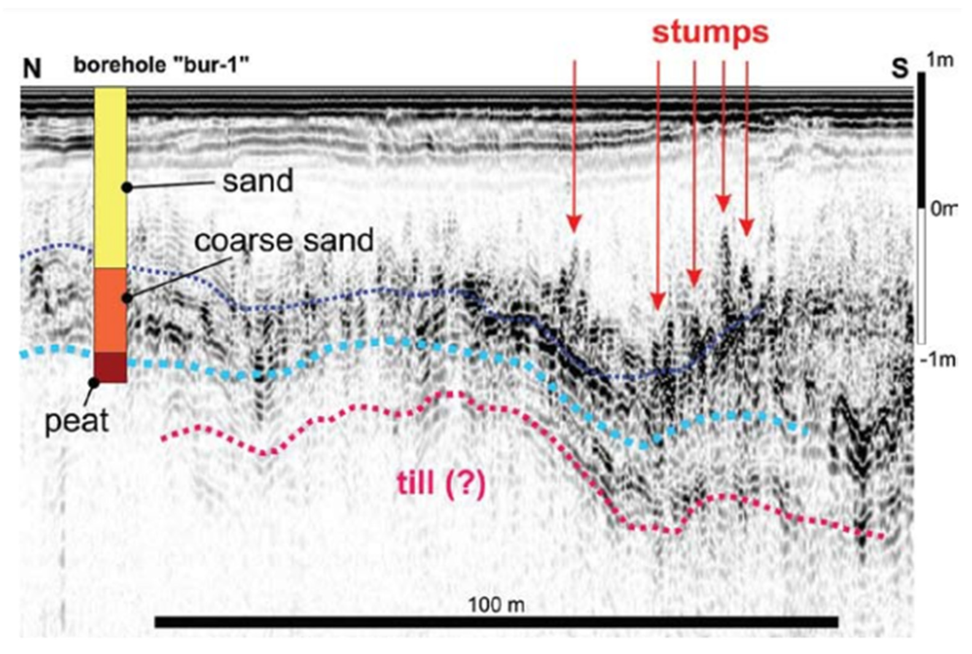
For nearshore and intertidal sites, documentation and sampling are often tide-dependent, and typically conducted at low tide for optimal exposure [42]. Techniques such as aerial LiDAR, drones, and high-resolution photogrammetry provide detailed elevation models, while pedestrian surveys allow for visual assessment and targeted sampling of partially exposed stumps, preservation conditions, and sediment features. To detect subsurface features, methods like ground-penetrating radar (GPR) (Figure 3), parametric echosounding, and terrestrial electric and electromagnetic induction (EMI) have been employed [43,44], though no single method serves as a universal solution [45].
Sub-fossil stumps and associated organic sediments present specific challenges due to their low acoustic impedance, which reduces reflection of low-frequency acoustic signals. Organic sediments often contain biogenic gases, such as methane, from decomposition processes, which disrupt and obscure acoustic signals [43]. Additionally, high porosity and water content can significantly attenuate high-frequency acoustic signals, reducing resolution and penetration depth. This moisture content also affects conductivity, impacting the efficacy of EMI and electrical resistivity methods [33]. Locations with high tidal variations enable marine (parametric) mapping techniques to be applied nearshore, while land-based EMI methods can extend further offshore [43].
Another essential factor is establishing tide datums to accurately assess stump elevations relative to contemporary and past sea-level data [5,39]. Harrison and Lyon [30] argue that while absolute elevations relative to mean tide level are useful, it is the relative differences in altitude between stumps at a given site that are more critical for determining rates of submergence. For accurate palaeogeographic modelling, employing a multi-method approach—including direct sampling through coring—can ground-truth geophysical data and improve interpretations of complex sedimentary environments [39]. Sediment core collection from areas surrounding and beneath submerged stumps is vital for understanding the environmental context, including chronology, depositional history, and paleoenvironmental conditions, although waterlogged sediments can be challenging.

4.2. Proxy Data for Landscape Reconstruction

Sediment cores, wood samples, and paleoecological proxies are essential in reconstructing the paleoenvironment of submerged forest sites. Analysis typically starts with wood species identification, as shifts in littoral tree species can indicate past climatic changes (e.g., [46]). Subfossil wood identification relies on physical characteristics and preservation, with specific wood types—such as cedar (Chamaecyparis spp., Juniperus spp.), pine (Pinus spp.), and Melaleuca (Callitris spp.)—benefiting from natural preservatives that enhance their longevity [39]. When preservation quality limits macroscopic wood identification, anthracological analysis—microscopic examination of charcoal—may be an alternative [47]. However, this approach depends on the availability of a comprehensive reference collection of regional wood anatomy (cf. [11]). Similarly, genomic analysis of wood requires a robust DNA reference database. To date, most efforts in wood DNA barcoding have focused on enforcing regulations against illegal logging [48,49], rather than on cultural heritage or archaeological research, although a recent case study highlights its potential for reconstructing forest ecosystem responses to past environmental change [50].
Chronology is obviously critical for determining timing of inundation and can sometimes be achieved through dendrochronology (e.g., [51] cf 11) or direct dating of the subfossil stumps (e.g., [6,39]). These species tend to respond to localised fluctuations in moisture availability rather than consistent annual climatic cycles, with variability evident even at sub-location or individual tree scales. As a result, they are generally unsuitable for precise calendar-year dating [52]. However, Rowell et al. [10] used ring-width measurements from 34 Melaleuca spp. stumps located along the shores of Macquarie Harbour, western Tasmania to estimate individual tree lifespans ranging from a few years to over a century. The age of the trees themselves were estimated from a radiocarbon age of 37.8 ± 0.75 ka obtained from a single stump. This result was interpreted as a minimum age, due to possible contamination from dissolved organic matter in the groundwater.
Chronology can also be obtained from radiocarbon dating of shell or peat in associated sediments and/or from Optically Stimulated Luminescence (OSL) dating of inorganic sediments (e.g., [11,34]). As Miao et al. [39] demonstrate, a range in age and elevation among samples does not always indicate relative sea-level rise (SLR), as trees may have died from other factors, such as storm-driven flooding or fire. However, for the most part submerged forests do provide valuable terrestrial markers of sea-level rise, recording the timing and extent of local marine transgression [5].
Where possible it is useful to situate local data within regional trends. For example, a compilation of terrestrial and marine in situ pine chronologies in northern central Europe by Kaiser et al. [6] revealed correlations between sedimentary environments and tree ages. Terrestrial samples generally clustered around the late Pleistocene (13,900–11,700 years BP), whilst trees buried in peat dated around 9000–8000 years BP, and those from the Baltic Sea and lakes mainly ranged from 8700 to 8200 years BP. Independent studies documented younger subfossil pines in peatlands that originated in the mid- and late Holocene [53]. These distributions reflect shifts in boreal forest ecosystems tied to late Quaternary climatic amelioration. However, ecosystem responses to climate forcing can exhibit temporal misalignments. For coastal forests, tree mortality and retreat may not occur in simple synchrony with rising sea levels, as multi-decadal lags can separate sea-level rise and coastal forest loss [54,55].
Proxy data from embedding sediments, particularly peat, is critical for characterizing and timing inundation events [56,57]. Marine microfossils (e.g., foraminifera, diatoms) and terrestrial microfossils (e.g., pollen, testate amoebae) are sensitive to salinity and other environmental changes, and hence can help document watertable fluctuations, sea-level rise and floodplain aggradation (e.g., [34,39,58]). However, as Rowell et al. [10] documented in Tasmania, the fossil pollen and macrofossil assemblages—interpreted as allochthonous—can differ significantly from the in situ Melaleuca fossil forest. By contrast, the pollen record from Esperance indicated a continuity of the (kwongan) ecology ([11], refer 5.3 below). This underscores the importance of differentiate between in situ and allochthonous assemblages to avoid misrepresenting past landscapes and ecological dynamics.
Additional proxies—such as terrestrial gastropods, insects, small vertebrates, and plant macrofossils—also serve as valuable palaeoenvironmental indicators. While these bioassemblages are more commonly associated with acidic peat deposits, they have also been recorded in calcareous soils linked to submerged forests in north Cornwall [58]. According to Howie and Gwynn [58], the preserved sediment assemblage likely reflects rapid dune encroachment over the forest site, before humification and the leaching of calcareous elements could occur.
The use of historical datasets and spontaneous observations from the public cannot be overlooked. Historical records of submerged forests, including early maps, sketches, and written accounts, offer baseline data on past coastal positions that provide a reference point for modern measurements and projections (e.g., [40,58]). They can also help identify specific events (e.g., storm surges or gradual shoreline retreat) responsible for submergence that help distinguishing between abrupt and gradual (eustatic) coastal changes (see above). Oral histories and cultural perspectives from ancient coastal communities also enhance the ecological and cultural context of findings and may offer insights into how human populations adapted to changing shorelines (e.g., [37,59,60].
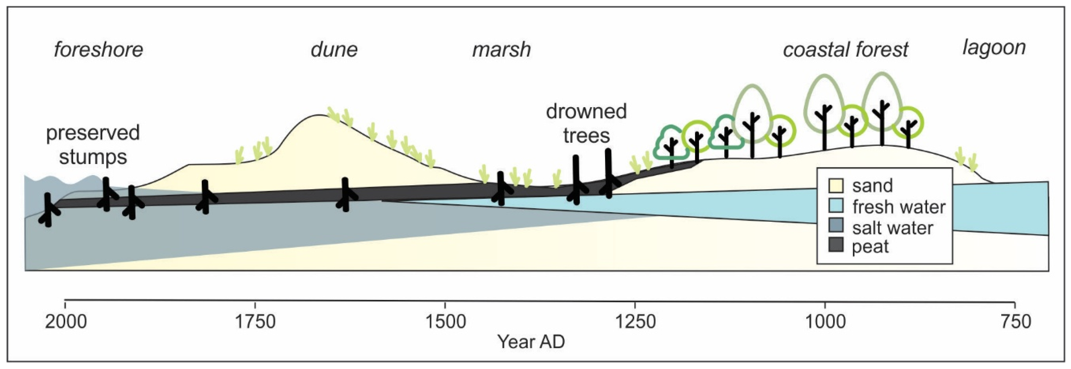
Generally, a multi-disciplinary approach is necessary for a holistic understanding of submerged trees and forests, from studying their past ecological conditions and hydrology, to how flooding affects their preservation. It is also crucial to integrate evidence from both sides of the waterline, especially given that the boundary between land and water has shifted over time—such as in response to eustatic sea-level rise—necessitating careful consideration of how these areas interact and influence one another [39,61,62]. The integration of geological, hydrological, ecological, and, in some cases, archaeological and ethnobotanical datasets within a GIS further enables assessment and understanding of coastal change and evolution of a palaeoforest site [39] (Figure 4). Chronological control from dating of in situ stumps and/or associated sediments is also vital to establish the timing of submergence and related landscape transitions.

5. Examples of Drowned Forests as Sites of Cultural Significance in Australia

5.1. Shea Creek

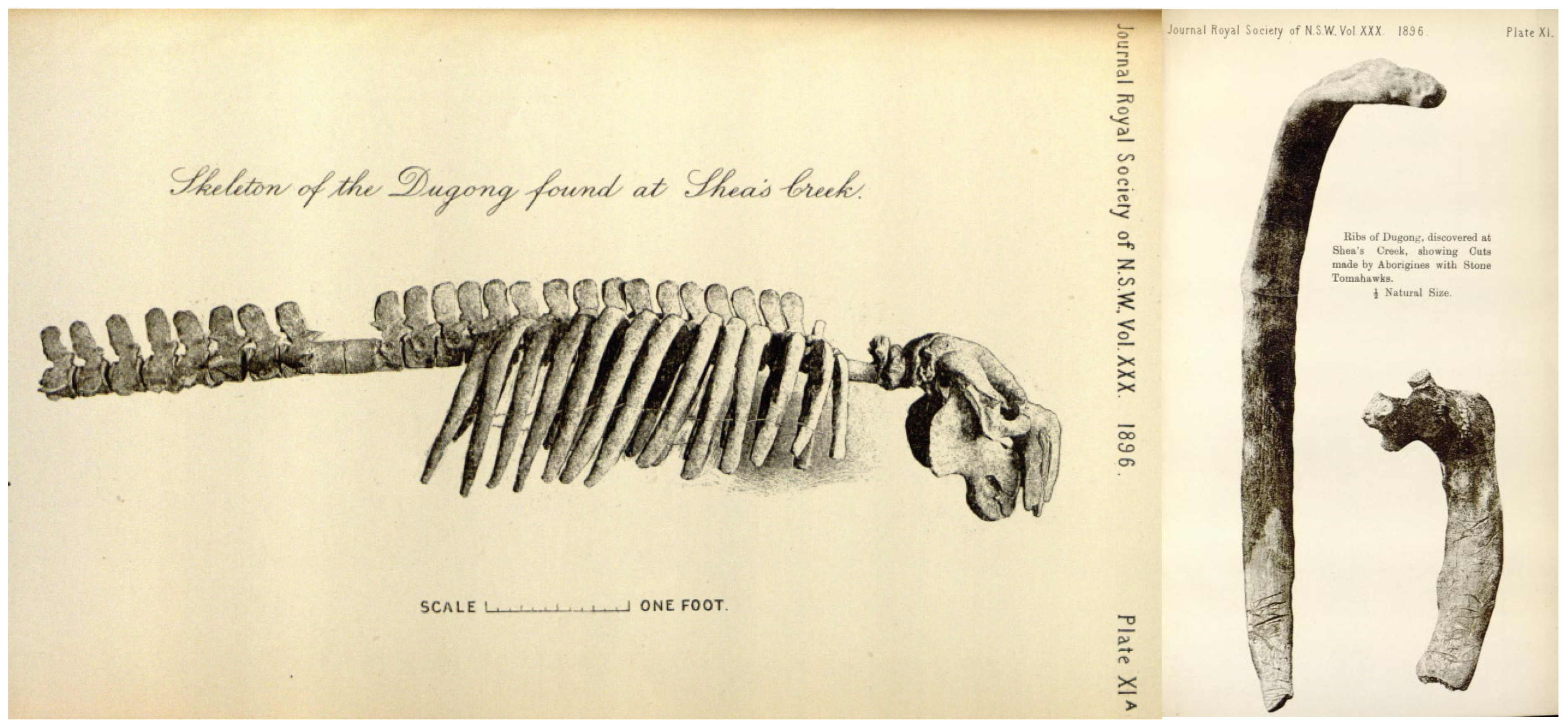
One of the more intriguing but possibly overlooked submerged forest sites is that of Shea Creek in New South Wales. In 1896, efforts began on the Alexandria Canal, linking Botany Bay to southern Sydney. The 5 m deep canal excavations not only unearthed sub-fossil trees within peat but also the bones of a dugong (Dugong dugong) set in a layer of shell-rich estuarine clay [63] (Figure 5). Remarkably, some of the bones showed marks of stone axe butchering and were scarred with ‘deep scratches and cuts, especially at their distal ends’ [24], p. 174. Stone axe heads (referred to by Etheridge et al. as tomahawks) were also found nearby, in deposits above and below the dugong skeleton indicating Aboriginal people inhabited the area of Shea’s Creek around this time.
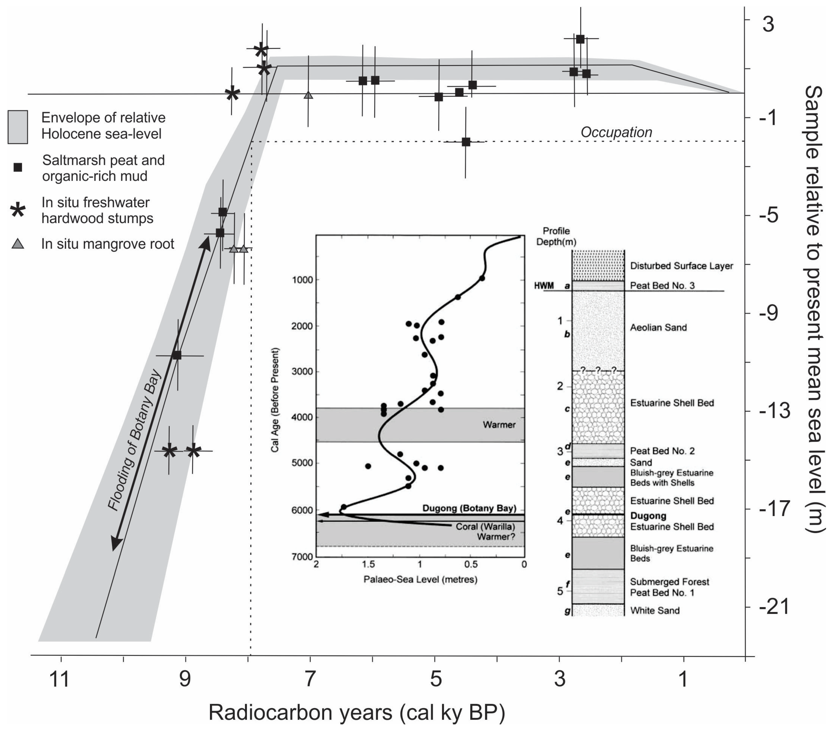
The profile as summarised by Haworth et al. [41] (see Figure 6) showed alternating layers of estuarine sand and shell, and peat full of terrestrial plant remains, indicating shifts between deeper tidal water and more exposed sub-aerial conditions. The base of the sedimentary sequence was a terrestrial unit containing stumps of swamp mahogany (Eucalyptus botryoides), some up to 75 cm in diameter, and a burnt Banksia (Banksia serrata). A higher, peaty, unit also included plant remains with in situ roots indicating a return to swamp conditions [41].
Although no absolute dates were obtained during the initial study, the authors write that, “…Neolithic man may have inhabited Botany Bay when the ocean level was about five feet [~150 cm] lower than present” or, if the stone axes were in situ, “… at perhaps even a more remote period” [24], p. 180. Comparison with the sea-level curve of Sloss et al. [40] puts this at around 8000 Cal ky BP ago (Figure 6). Subsequent radiocarbon dates of the dugong bones from this site provided age estimates of 6541–6145 Cal BP (adjusted for marine residence time) [41]. Ages of wood samples (Eucalyptus resinifera and Angophora costata) found under marine sediments within a few kilometres of the dugong site provided ages between 10,180 and 8457 Cal ky BP. Comparison of this older age estimate with the sea-level curve of Sloss et al. [40] indicates initial post-Glacial flooding of the Botany Bay with water levels around 19 m below present (Figure 6).
The findings not only provide evidence of human occupation and resource use but also of changing environmental conditions and sea levels along the NSW coast during the Holocene. The stratigraphy at the Alexandria canal site showed that sea level had risen originally over what had once been heavily forested land, after which there appeared to have been a complicated history of marine advance and retreat. The presence of dugong is indicative warmer waters, an interpretation supported by subsequent evidence of warmer climatic conditions in central New South Wales in the mid-Holocene [41,46,64,65].

5.2. Lake Jasper and Other South Coast Sites, Western Australia

Yoondaddup, or Lake Jasper, is not only recognised as one of the earliest studies of submerged landscapes in Australia, but is also deeply significant to the Wadandi people as a place of creation, marking the movement of ancestral people when seismic activity shook the Country [66]. The documentation by Davies et al. [66] describes how the old people left their camp at Yoondaddup during that time, and when they returned, they found the landscape transformed with hills pushed out of the ground. This is when people left the area and spread out across Country and sung the songs of their creation.
In 1988 severe drought conditions exposed evidence of some of the campsites. Subsequent diver surveys at Yoondaddup uncovered numerous submerged tree and Xanthorrhoea spp. stumps at depths of up to 3.9 m, along with several hundred stone (microlithic) artefacts found at depths reaching 10 m [67,68]. The lake’s hydrology is influenced by fluctuations in the regional water table, which are driven by both precipitation patterns and stream blockage caused by dune encroachment linked to eustatic sea-level rise. The subfossil trees, dated to approximately 4000–3400 years BP, mark a once-wooded shoreline or pre-lake surface that was inundated as the lake expanded under the influence of advancing coastal dunes. Potential exists for palaeoecological analysis of the stumps and associated sediments to reconstruct the late–mid Holocene palaeocultural landscape.
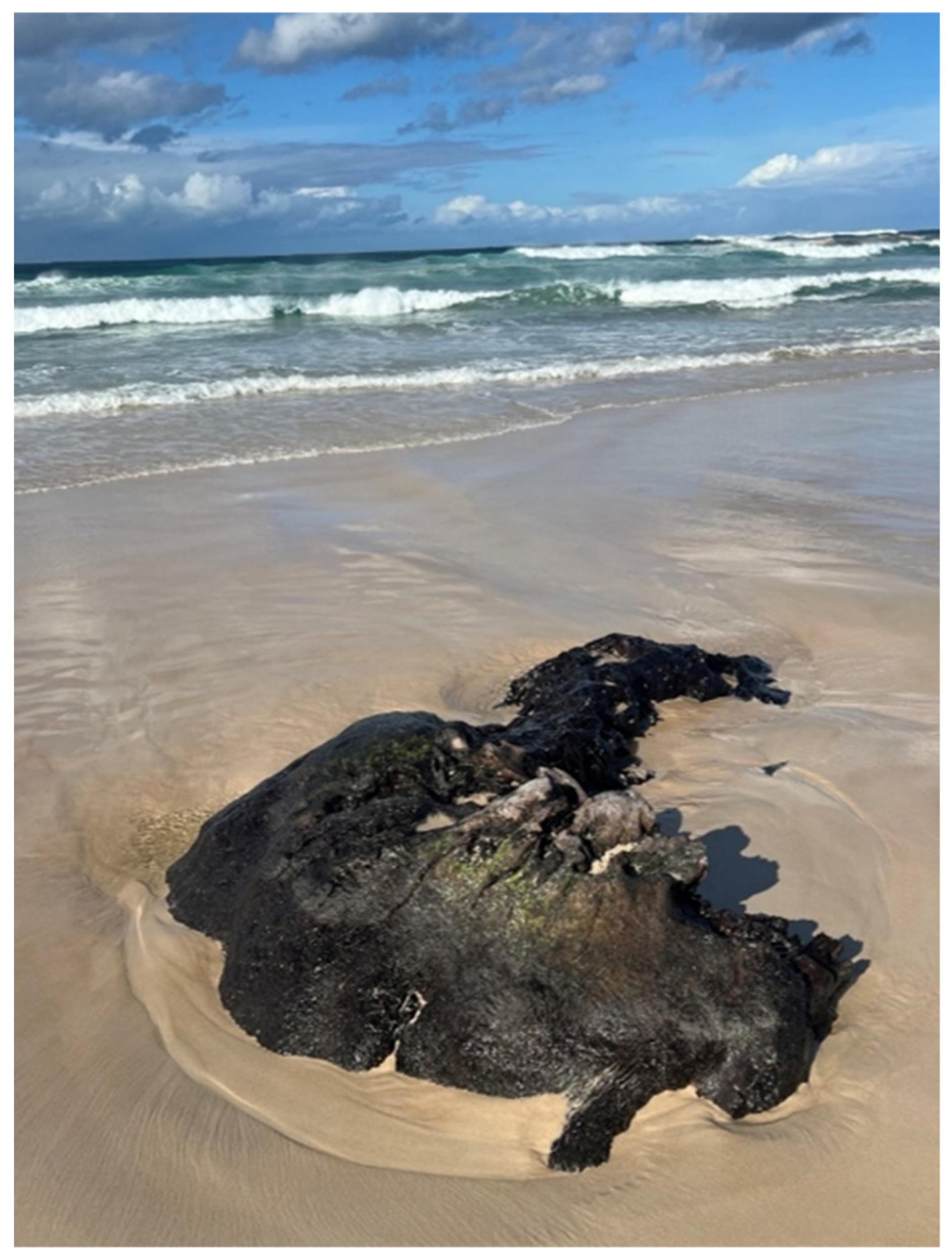
In a subsequent study, Dortch [69] reported intertidal or subtidal tree stumps from various localities along the southwest coast, including Broke Inlet (Eucalyptus marginata), Wilson Inlet (Melaleuca spp.), Stokes Inlet (M. cuticularis), and in the surf zone off Trigelow Beach, located 300 km west of Esperance. Age estimates for these stumps range from 7387 ± 74 cal BP (Wk3295) to 8091 ± 195 cal BP (WAIT43), suggesting a widespread event of forest inundation, likely linked to rising sea levels. More recent observations of subfossil trees along the southwest coast indicate the persistence of large tree forms, with some specimens potentially indicative of ‘tingle’ (Eucalyptus jacksonii) trees (Figure 7). However, Muir [70] identified the stumps at the mouth of the Warren River as Yate (Eucalyptus cornuta) – also known to Noongar peoples as Mo, Yandil, Yeit (see Yate (Walpole Wilderness Eucalypts) · iNaturalist, https://www.inaturalist.org/guide_taxa/2005645 accessed on 14 June 2025), which can grow up to 20 m tall and are endemic to the region. Muir [70] reported these stumps to be 8300 BP years old, and it is assumed this is a calibrated age, although no details are provided. Given the relatively steep shelf along this section of the coast, sea level at this time would have been within a kilometre of the modern shoreline. These findings provide compelling evidence for the ecological transformation of low-lying coastal landscapes during the mid-Holocene, as marine transgression inundated forested environments.
The studies of submerged forests in this region highlights the significance of such landscapes for Indigenous cultural connections, with Lake Jasper serving as an important case study within the broader context of submerged landscape research in Australia. By situating the area within a powerful Noongar creation story, Noongar Elders have prompted the incorporation of cultural protocols into all aspects of future research on drowned forests and sub-fossil trees in this region to generate a deeper understanding of both past environmental change and cultural significance of these ancestral landscapes.

5.3. Wharton Beach, Southern Coast of Western Australia

The intertidal forest site at Wharton Beach on the southern coast of Western Australia has been documented by Ward et al. [11], with details found therein. The study examined subfossil tree stumps preserved in situ within intertidal sands, employing a multidisciplinary approach that included radiocarbon dating, anthracology, and sediment analysis to reconstruct the forest’s ecological setting and the timing of inundation. The findings indicate that the trees thrived during a period of stable sea levels around 7400 years BP before being submerged due to post-glacial sea-level rise. A sampled stump was tentatively identified as Taxandria juniperina (commonly known as watti), largely based on the presence of spreading buttress roots. Watti is a native species with prop roots generally confined to freshwater swamps and watercourses, and now mainly found further west. Absolute identification was limited by poor preservation of the wood features and a limited regional anthracological database.
The identifiable pollen assemblage in the associated peats closely resembles the modern kwongan vegetation in the region, including Ericaceae (heath), Casuarinaceae (Allocasuarina/Casuarina), Proteaceae, and Myrtaceae—including Eucalyptus spp. and a wide diversity of Leptospermoid genera. This indicated relative ecological continuity over at least 7000 years, despite sea-level changes and climate variability [11]. This research underscores the value of submerged forests as records of environmental change and provides insights into the kinds of environments likely encountered—and possibly shaped—by Aboriginal people living along now-inundated coastlines during the Holocene.
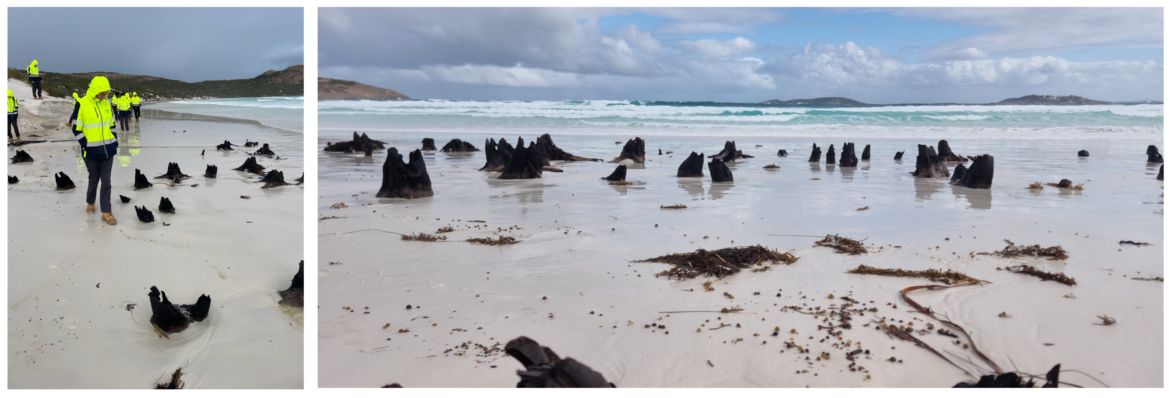
Since the publication of this study, additional subfossil trees and peat deposits have been uncovered along the Wudjari coastline through erosion of a metre of more of beach sand (Figure 8). While it remains uncertain whether these sporadic exposures indicate a long-term trend of coastal erosion, they at least allow for opportunistic recording and sampling by the Indigenous Rangers who regularly monitor the coastline.
Plans are in place to build on this initial work through targeted field and laboratory investigations, as outlined in Section 4, integrating Western scientific methods within a broader cultural framework informed by ancestral sea-country knowledge. Importantly, these features have created a valuable opportunity to engage with Wudjari communities in conversations about long-term environmental change and the enduring cultural connections across the Esperance region.
This research program, under cultural leadership, is multidisciplinary, and that means the integration of our knowledge in understanding place, landscape and change—this is our cultural discipline, and our way is mapping and managing our cultural corridors—that are linked together by special places—following the pathways of our Ancestors, including the now submerged places and pathways.
Dr. Ron “Doc” Reynolds, Wudjari Elder and Senior Cultural Advisor to ETNTAC.

5.4. Badger Beach, Narawntaup National Park, Tasmania

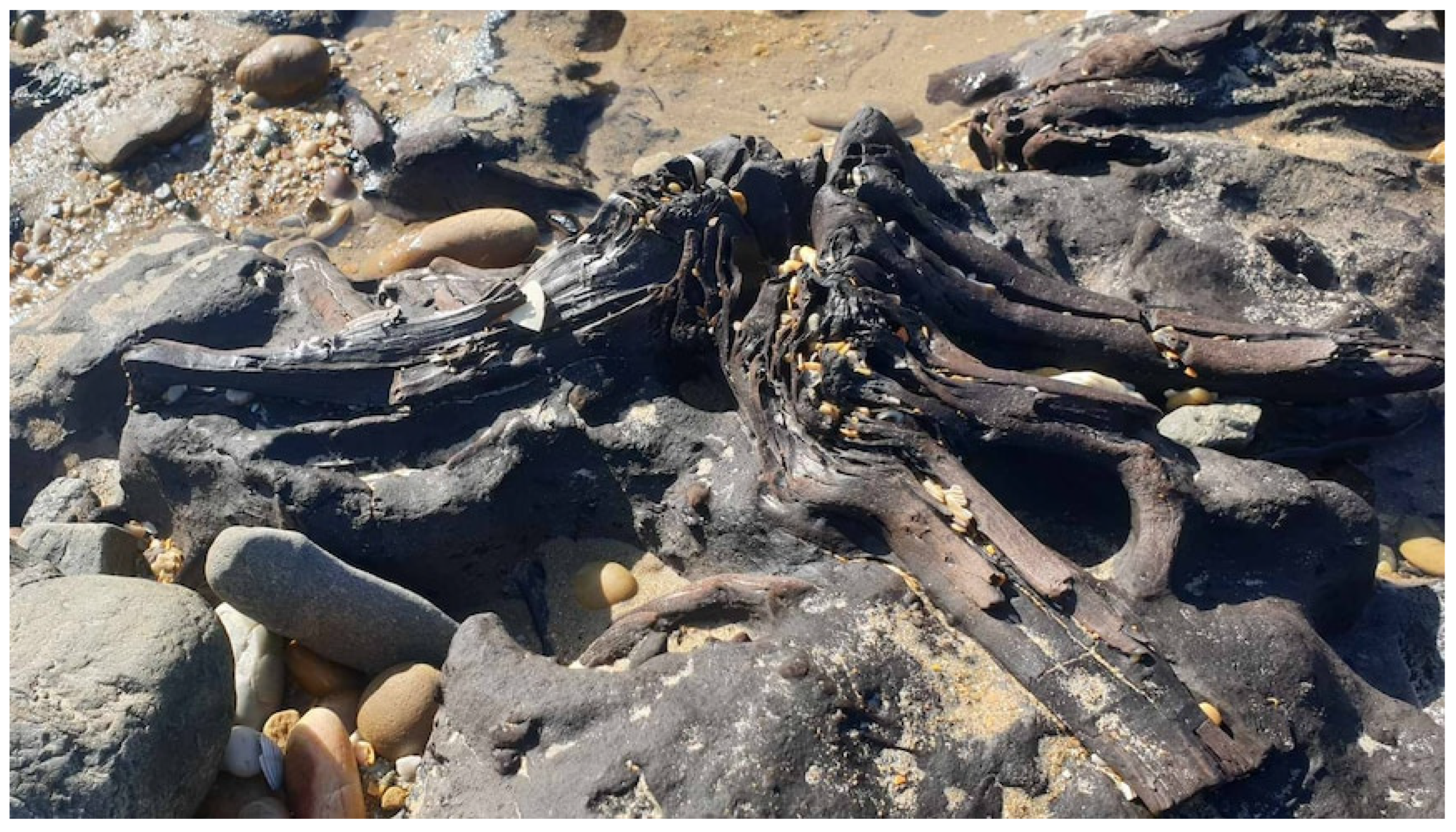
In October 2024, reports of another intertidal forest site, this one along Badger Beach in northern Tasmania, were highlighted in the news (Figure 9). According to the news reports, many of the trees were clumped together, resembling the trunk structures of Melaleuca spp. and were embedded in fine mud as “soft like plasticine” [71]. An aboriginal educator, a Palawa man, also indicated the trees were most likely an ancient Melaleuca spp. or tea tree forest and culturally significant. The trees provided support for all others to grow and are viewed as elders by the Palawa community [72].
The fossil forest site at Coal Head site in western Tasmania also comprised almost monospecific Melaleuca (probably M. ericifolia), with the age of the site estimated to be older than approximately 38,000 years [10]. Based on this, Rowell et al. [10] suggested the site may pre-date both the earliest confirmed human occupation of Tasmania [73] and earlier inferred dates (e.g., [74]), which range from 34,000 to 70,000 years ago. Further, the fossil forest here was interpreted as representative of pre-occupation fire regimes, because of the rarity today of coastal paperbark forests containing rainforest species from more frequent burning. Alternatively, early human–environment interactions may be too subtle to be detected in the palaeoecological record. Regardless, the Coal Head forest can be said to offer a rare window into Pleistocene vegetation structure and environmental context during the early period of human occupation in Tasmania.

5.5. Kurra Kurrin

In Fennel Bay, New South Wales, lies a much older submerged fossil forest site known as Kurra Kurrin, meaning “men turned into rock” [75]. This site holds deep cultural significance for the Awabakal people. According to records from Reverend Lancelot Threlkeld in the 1830s, it was believed to be a place where people were turned to stone as punishment for wrongdoing [75]. A pamphlet from the Lake Macquarie City Council [76] indicates the site comprises over 500 petrified trees—most ranging between 30 and 50 cm in diameter—belonging to an ancient Glossopteris spp. forest, thought to have been buried in volcanic ash. Although these trees fossilised long before human occupation, when the coastline was much farther east and Lake Macquarie was a vast forested peat swamp with rivers, floodplains, and small lakes, they have become deeply interwoven into Aboriginal mythology. Their enduring presence in oral traditions highlights how landscapes, even those geologically ancient or dramatically altered, continue to hold cultural meaning within Indigenous worldviews. Interestingly, the Kurra Kurrin site lies only 50 km from the more recently exposed subfossil trees at Munmorah National Park, shown in Figure 1, suggesting a broader regional resonance in how the latter may be understood and valued.

6. Overview and Conclusions

The case studies above highlight the significant cultural and ecological value of drowned forests in understanding past—including submerged—landscapes in Australia. While all documented sites to date have been located in intertidal to supratidal zones, evidence from international studies indicates potential for the existence of subtidal fossil forests, particularly where buried and protected below modern sediments. These preserved tree remains offer critical insights into past environmental conditions, regional sea-level changes, and long-term ecosystem dynamics. Through the analysis of sub-fossil wood and associated sediments, it is possible to track shifts in vegetation zones, hydrological regimes, and climate patterns, providing a deeper understanding of how ancient coastlines and their ecosystems transformed over time.
These natural archives also document climatic changes that Indigenous Australian communities have long adapted to, shaping their cultural landscapes and practices. Moreover, they hold cultural significance by providing a tangible link to ancient, occupied landscapes—including the very rare discovery of a processed dugong. These organic-based records complement and enhance more common archaeological records such as midden sites, intertidal fish traps and stone or shell tools that are used to infer patterns of coastal use. In some cases, the palaeoecology indicated by the sub-fossil trees themselves, or by proxy records—including charcoal—within associated peat or sediment deposits may also point to past human activities such as cultural burning or other forms of environmental stewardship, recorded in both sediment and story.
These overlaps underscore the value of integrating Indigenous and scientific knowledge systems in research on coastal and submerged environments. Western methods contribute tools for measuring and modelling long-term ecological change, while Indigenous perspectives provide a continuous cultural framework for interpreting the significance of these landscapes and their transformations. Co-designed approaches that bring these systems into dialogue offer a more holistic understanding of Australia’s dynamic coastal past (e.g., [11,77,78,79]).
Another possible area for development is the creation of a regional database for sub-fossil trees and for peats, such as that developed for the UK [80], which can feed into more global databases such as Jiren et al.’s [81] PEATMAP and the University of Leeds’ ‘PeatDataHub’ (https://peatdatahub.net/, accessed on 12 April 2025). Indeed, the broader need identified by Pemberton [13] for investigations into the spatial extent, condition, and management requirements of Australian peatlands arguably remains as relevant as ever. The UK’s inventory of intertidal, nearshore and offshore peat deposits and submerged forests around the English coast was driven by an enhanced interest in submerged landscapes and their nature. A similar enhanced interest in Australia’s submerged palaeolandscapes is being invigorated by contemporary discoveries of exposed sub-fossil trees. As one public member commented in regard to the exposed trees on the north coast of Tasmania, “They’re an extraordinary window into the past. They’re so real, it’s very easy to imagine what once stood there. Whereas some geological remains are a lot more cryptic, the stumps and roots of trees are very obvious and you start to wonder how, how the earth changed” [71].
While such databases can be valuable for identifying research gaps, informing management practices, and fostering collaboration, they must be developed with care. It is essential that access to information—particularly regarding culturally sensitive sites—does not result in exploitation or damage. Through genuine collaboration, applied science can be meaningfully integrated with cultural leadership models, supporting more effective and respectful management of heritage places and landscapes. In doing so, these efforts help illuminate the deep, layered, and enduring connections between people and place—connections that resonate across all communities and generations:
We want our grandchildren to see Country the way our Ancestors did, it is our way of life—healthy country means healthy mob”,
Jeremy Smith, ETNTAC Tjaltjraak Healthy Land and Sea Program.

Author Contributions

I.W.: Conceptualisation, Writing—Original draft, Review and Editing, Visualisation; D.R.G. Writing—Review and Editing; D.R. Writing—Review and Editing. All authors have read and agreed to the published version of the manuscript.

Funding

This paper was written in the authors’ own time and received no specific funding from any public, private, or not-for-profit agency.

Data Availability Statement

Not applicable.

Acknowledgments

We extend our gratitude to the First Nations individuals from Esperance Tjaltjraak Native Title Aboriginal Corporation who generously shared their perspectives in support of this work. Their contributions were provided freely through verbal informed consent, with an understanding that their insights may be incorporated into this publication. We acknowledge their intellectual and cultural property rights and remain committed to ethical and respectful engagement, in line with the AIATSIS Code of Ethics for Aboriginal and Torres Strait Islander Research. We also thank the reviewers for their helpful comments. We also thank Chris Morton (Amateur Geological Society of the Hunter Valley) and Oliver Berry (CSIRO, Australia) for providing the images of sub-fossil trees. Finally, we thank the reviewers for their helpful comments.

Conflicts of Interest

The authors declare no conflict of interest.

Note

1
See also Uncle Doc and Elders tell the story of Wudjari ancient coastlines|Indigenous. (https://www.indigenous.gov.au/stories/uncle-doc-and-elders-tell-story-wudjari-ancient-coastlines, accessed on 10 June 2025).

References

  1. Bailey, G.; Momber, G.; Bell, M.; Tizzard, L.; Hardy, K.; Bicket, A.; Tidbury, L.; Benjamin, J.; Hale, A. Great Britain: The Intertidal and Underwater Archaeology of Britain’s Submerged Landscapes. In The Archaeology of Europe’s Drowned Landscapes; Coastal Research Library; Bailey, G., Galanidou, N., Peeters, H., Jöns, H., Mennenga, M., Eds.; Springer: Cham, Switzerland, 2020; Volume 35. [Google Scholar]
  2. Fedje, D.W.; Heiner, J. Drowned forests and archaeology on the continental shelf of British Columbia. Geology 2000, 28, 99–102. [Google Scholar] [CrossRef]
  3. Campbell, J.A.; Baxter, M.S. Radiocarbon measurements on submerged forest floating chronologies. Nature 1979, 278, 409–413. [Google Scholar] [CrossRef]
  4. Godwin, H.; Newton, L. The Submerged Forest at Borth and Ynyslas, Cardiganshire. New Phytol. 1938, 37, 333–344. [Google Scholar] [CrossRef]
  5. Heyworth, A. Submerged forests as sea-level indicators. In Sea-Level Research: A Manual for the Collection and Evaluation of Data; van der Plassche, O., Ed.; Geo Books: Norwich, UK, 1986; pp. 401–411. [Google Scholar]
  6. Kaiser, K.; Oldorff, S.; Breitbach, C.; Kappler, C.; Theuerkauf, M.; Scharnweber, T.; Schult, M.; Küster, M.; Engelhardt, C.; Heirich, I.; et al. A submerged pine forest from the early Holocene in the Mecklenburg Lake District, Northern Germany. Boreas 2018, 47, 910–925. [Google Scholar] [CrossRef]
  7. Reid, C. Submerged Forests. The Cambridge Manuals of Science and Literature; Cambridge University Press: Cambridge, UK, 1913. [Google Scholar]
  8. Sergeev, A.; Sivkov, V.; Zhamoida, V.; Ryabchuk DBitinas, A.; Mažeika, J. Holocene organic-rich sediments within the Curonian Spit coast, the south-eastern Baltic Sea. Baltica 2017, 28, 41–50. [Google Scholar] [CrossRef]
  9. Williams, M.D.; Doyle, E. Dates from drowned mid-Holocene landscapes on the central western Irish seaboard. Ir. J. Earth Sci. 2014, 32, 23–27. [Google Scholar] [CrossRef]
  10. Rowell, M.V.; Jordan, G.J.; Barnes, R.W. An in situ, Late Pleistocene Melaleuca fossil forest at Coal Head, western Tasmania, Australia. Aust. J. Bot. 2001, 49, 235–244. [Google Scholar] [CrossRef]
  11. Ward, I.; Tjaltjraak Rangers Guilfoyle, D.; O’Donnell, A.; Byrne, C.; Macphail, M.; Hopper, S.D. Remnant peat deposit provide clues to the inundated cultural landscapes of Kepa Kurl, southwestern Australia. Holocene 2023, 33, 671–684. [Google Scholar] [CrossRef]
  12. Whinam, J.; Hope, G.; Clarkson, B. Mires Down Under—The Peatlands of Australasia. In Mires from Pole to Pole; The Finnish Environment; Lindholm, T., Heikkilä, R., Eds.; Finnish Environment Institute: Helsinki, Finland, 2012; Volume 38. [Google Scholar]
  13. Pemberton, M. Australian peatlands: A brief consideration of their origin, distribution, natural values and threats. J. R. Soc. West. Aust. 2005, 88, 81–89. [Google Scholar]
  14. Whinam, J.; Hope, G. The Peatlands of the Australasian Region. In Moore—Von Sibirien bis Feuerland (Mires—From Siberia to Tierra del Fueg); Steiner, G.M., Ed.; Biologiezentrum der Oberoesterreichischen Landesmussen: Linz, Austria, 2005; Volume 1, pp. 397–434. [Google Scholar]
  15. Longmore, M.E.; Heijnis, H. Aridity in Australia: Pleistocene records of Palaeohydrological and Palaeoecological change from the perched lake sediments of Fraser Island, Queensland, Australia. Quat. Int. 1999, 57–58, 35–47. [Google Scholar] [CrossRef]
  16. Adam, P.; Horwitz, P. Temperate coastal peatlands in Australia. Stapfia 2005, 85, 413–415. [Google Scholar]
  17. Butler, K.; McIllwraith, P. Garihma (to Care for): Examining recent media coverage of Bulam (tea tree) through a cultural lens. Wellbeing 2023, 26. [Google Scholar] [CrossRef]
  18. Hansen, V.; Horsfall, J. Noongar bush medicine. In Medicinal Plants of the South-West of Western Australia; UWA Press: Perth, Australia, 2020. [Google Scholar]
  19. Lassak, E.; McCarthy, T. Australian Medicinal Plants; New Holland: Sydney, Australia, 2001. [Google Scholar]
  20. Lullfitz, A.; Reynolds, R.; Dabb, A.; Knapp, L.; Pettersen, C.; Hopper, S. Contemporary distribution of Macrozamia dyeri (Zamiaceae) is correlated with patterns of Nyungar occupation in south-east coastal Western Australia. Austral Ecol. 2020, 45, 933–947. [Google Scholar] [CrossRef]
  21. Leubbers, R.A. Ancient boomeranges discovered in South Australia. Nature 1975, 253, 39. [Google Scholar] [CrossRef]
  22. Clarke, P.A. The Aboriginal ethnobotany of the South East of South Australia region. Part 2: Foods, medicines and narcotics. Trans. R. Soc. S. Aust. 2015, 139, 247–272. [Google Scholar] [CrossRef]
  23. Bandaranayake, W.M. Traditional and medicinal uses of mangroves. Mangroves Salt Marshes 1998, 2, 133–148. [Google Scholar] [CrossRef]
  24. Huxham, M.; Dencer-Brown, A.; Diele, K.; Kathiresan, K.; Nagelkerken, I.; Wanjiru, C. Mangroves and People: Local Ecosystem Services in a Changing Climate. In Mangrove Ecosystems: A Global Biogeographic Perspective: Structure, Function, and Services; Rivera-Monroy, V.H., Lee, S.Y., Kristensen, E., Twilley, R.R., Eds.; Springer International Publishing: Cham, Switzerland, 2017. [Google Scholar]
  25. Ditchfield, K.; Manne, T.; Hook, F.; Ward, I.; Veth, P. Coastal occupation before the big Swamp: Results from excavations at John Wayne Country rock shelter on Barrow island. Archaeol. Ocean. 2018, 53, 163–178. [Google Scholar] [CrossRef]
  26. Bloom, A.L. Late-Pleistocene fluctuations of sea level and post-glacial crustal rebound in coastal Maine. Am. J. Sci. 1963, 261, 862–879. [Google Scholar] [CrossRef]
  27. Frankel, L.; Crowl, G.H. Drowned Forests Along the Eastern Coast of Prince Edward Island, Canada. J. Geol. 1961, 69, 352–357. [Google Scholar] [CrossRef]
  28. Fujii, S.; Nasu, N.; Smith, A.J.; Fuji, N.; Mizutani, Y.; Shi makura, M.; Konishi, K.; Igarashi, C.; Muramoto, J.; Take mura, T.; et al. Submerged forest off Nyuzen, Kurobega alluvial fan, Toyama Bay, Central Japan. Boreas 1986, 15, 265–277. [Google Scholar] [CrossRef]
  29. Gontz, A.M.; Maio, C.V.; Rueda, L. The Duxbury sunken forest—Constraints for local, late Holocene environmental changes resulting from marine transgression, Duxbury Bay, Eastern Massachusetts, USA. J. Coast. Res. 2013, 29, 168–176. [Google Scholar] [CrossRef]
  30. Harrison, W.; Lyon, C.J. Sea-level and crustal movements along the New England–Acadian shore, 4500–3000 BP. J. Geol. 1963, 71, 96–108. [Google Scholar] [CrossRef]
  31. Lambeck, K.; Nakada, M. Late Pleistocene and Holocene sea-level change along the Australian coast. Glob. Planet. Chang. 1990, 3, 143–176. [Google Scholar] [CrossRef]
  32. Lyon, C.J.; Harrison, W. Rates of submergence of coastal New England and Acadia. Science 1960, 132, 295–296. [Google Scholar] [CrossRef]
  33. Ratcliffe, J.; Straker, V. The Early Environment of Scilly: Palaeoenvironmental Assessment of Cliff-Face and Intertidal Deposits; Cornwall Archaeological Unit Publication: Truro, UK, 1996. [Google Scholar]
  34. Reese, C.A.; Harley, G.L.; Delong, K.L.; Bentley Sr, S.J.; Xu, K.; Gonzalez, S.; Truong, J.T.; Obelcz, J.; Caporaso, A. Stratigraphic pollen analysis performed on a late Pleistocene cypress forest preserved on the northern Gulf of Mexico continental shelf. J. Quat. Sci. 2018, 33, 865–887. [Google Scholar] [CrossRef]
  35. Atwater, B.F.; Yamaguchi, D.K. Sudden, probably co-seismic submergence of Holocene trees and grass in coastal Washington State. Geology 1991, 19, 706–709. [Google Scholar] [CrossRef]
  36. Donnelly, J.P. Evidence of past intense tropical cyclones from back-barrier saltpond sediments: A case study from Islade Culebrita, Puerto Rico, USA. J. Coast. Res. 2005, 42, 201–210. [Google Scholar]
  37. Jengo, J.W. After the Deluge, Part II: Flood Basalts, Glacial Torrents, and Lewis and Clark’s “Swelling, boiling & whorling” River Route to the Pacific. We Proceeded 2015, 41, 8–23. [Google Scholar]
  38. Langridge, R.M.; Basili, R.; Basher, L.; Wells, A.P. Late Holocene landscape change history related to the Alpine Fault determined from drowned forests in Lake Poerua, Westland, New Zealand. Hazards Earth Syst. Sci. 2012, 12, 2051–2064. [Google Scholar] [CrossRef]
  39. Maio, C.V.; Gontz, A.M.; Weidman, C.R.; Donnelly, J.P. Late Holocene marine transgression and the drowning of a coastal forest: Lessons from the past, Cape Cod, Massachusetts, USA. Palaeogeogr. Palaeoclimatol. Palaeoecol. 2014, 393, 146–158. [Google Scholar] [CrossRef]
  40. Sloss, C.R.; Murray-Wallace, C.V.; Jones, B.G. Holocene sea-level change on the southeast coast of Australia: A review. Holocene 2007, 17, 999–1014. [Google Scholar] [CrossRef]
  41. Haworth, R.J.; Baker, R.G.V.; Flood, P.J. A 6000 year-old fossil dugong from Botany Bay: Inferences about changes in Sydney’s climate, sea levels and waterways. Aust. Geogr. Stud. 2004, 42, 46–59. [Google Scholar] [CrossRef]
  42. Bell, M. Chapter 27—Intertidal survey and excavation. In Oxford Handbook of Wetland Archaeology; Menotti, F., O’Sullivan, A., Eds.; Oxford University Press: Oxford, UK, 2013; pp. 466–481. [Google Scholar]
  43. Missiaen, T.; Evangelinos, D.; Claerhout, C.; De Clercq, M.; Pieters, M.; Demerre, I. Archaeological prospection of the nearshore and intertidal area using ultra-high resolution marine acoustic techniques: Results from a test study on the Belgian coast at Ostend-Raversijde. Geoarchaeology 2017, 33, 386–400. [Google Scholar] [CrossRef]
  44. Sherlock, S.J. A Submerged Forest on the Foreshore at Redcar, NZ 60302570. Yorks. Archaeol. J. 2019, 91, 162–166. [Google Scholar] [CrossRef]
  45. Bates, C.R.; Bates, M.R. Palaeogeographic Reconstruction in the Transition Zone: The Role of Geophysical Forward Modelling in Ground Investigation Surveys. Archaeol. Prospect. 2016, 23, 311–323. [Google Scholar] [CrossRef]
  46. Jones, R.L. Late Holocene vegetational changes on the Illawarra coastal plain, New South Wales, Australia. Rev. Palaeobot. Palynol. 1990, 65, 37–46. [Google Scholar] [CrossRef]
  47. Théry-Parisot, I.; Chabal, L.; Chrzavzez, J. Anthracology and taphonomy from wood gathering to charcoal analysis. A review of the taphonomic processes modifying charcoal assemblages, in archaeological contexts. Palaeogeogr. Palaeoclimatol. Palaeoecol. 2010, 291, 142–153. [Google Scholar] [CrossRef]
  48. Jiao, L.; Lu, Y.; He, T.; Guo, J.; Yin, Y. DNA barcoding for wood identification: Global review of the last decade and future perspective. IAWA J. 2020, 41, 620–643. [Google Scholar] [CrossRef]
  49. Low, M.C.; Schmitz, N.; Boeschoten, L.E.; Cabezas, J.A.; Cramm, M.; Haag, V.; Koch, G.; Meyer-Sand, B.R.V.; Paredes-Villanueva, K.; Price, E.; et al. Tracing the world’s timber: The status of scientific verification technologies for species and origin identification. IAWA J. 2022, 44, 63–84. [Google Scholar] [CrossRef]
  50. Wagner, S.; Seguin-Orlando, A.; Leplé, J.C.; Leroy, T.; Lalanne, C.; Labadie, K.; Aury, J.M.; Poirier, S.; Wincker, P.; Plomion, C.; et al. Tracking population structure and phenology through time using ancient genomes from waterlogged white oak wood. Mol. Ecol. 2024, 33, e16859. [Google Scholar] [CrossRef]
  51. Lyon, C.J.; Goldthwaith, J.W. An Attempt to Cross-Date Trees in Drowned Forests. Geogr. Rev. 1934, 24, 605–614. [Google Scholar] [CrossRef]
  52. Heinrich, I.; Allen, K. Current Issues and Recent Advances in Australian Dendrochronology: Where to Next? Geogr. Res. 2013, 51, 180–191. [Google Scholar] [CrossRef]
  53. Edvardsson, J.; Stoffel, M.; Corona, C.; Bragazza, L.; Leuschner, H.H.; Charman, D.J.; Helama, S. Subfossil peatland trees as proxies for Holocene palaeohydrology and palaeoclimate. Earth-Sci. Rev. 2016, 163, 118–140. [Google Scholar] [CrossRef]
  54. Chen, Y.; Kirwan, M.L. Upland forest retreat lags behind sea- level rise in the mid- Atlantic coast. Glob. Change Biol. 2023, 30, e17081. [Google Scholar] [CrossRef]
  55. Craft, C. Tidal freshwater forest accretion does not keep pace with sea level rise. Glob. Change Biol. 2012, 18, 3615–3623. [Google Scholar] [CrossRef]
  56. Amorosi, A.; Bruno, L.; Cacciari, M.; Campo, B.; Rossi, V. Tracing marine flooding surface equivalents across freshwater peats and other wetland deposits by integrated sedimentological and pollen data. Int. J. Coal Geol. 2021, 246, 103830. [Google Scholar] [CrossRef]
  57. Hunter, R.D.; Panyushkina, I.P.; Leavitt, S.W.; Wiedenhoeft, A.C.; Zawiskie, J. A multiproxy environmental investigation of Holocene wood from a submerged conifer forest in Lake Huron, USA. Quat. Res. 2006, 66, 67–77. [Google Scholar] [CrossRef]
  58. Howie, F.; Gwynn, A. The sub-fossil assemblage from a Holocene calcareous palaeosol in Daymer Bay, North Cornwall. Geosci. South-West Engl. 2013, 13, 191–201. [Google Scholar]
  59. Nunn, P.D.; Reid, N.J. Aboriginal Memories of Inundation of the Australian Coast Dating from More than 7000 Years Ago. Aust. Geogr. 2015, 47, 11–47. [Google Scholar] [CrossRef]
  60. Sanders, A. Oral Histories Documenting Changes in Wheatbelt Wetlands. Unpublished Report to Dept. Conservation and Land Management, Western Australia. 1991. Available online: https://library.dbca.wa.gov.au/static/Journals/080058/080058-91.02.a.pdf (accessed on 15 January 2024).
  61. Halligan, J.J. Crossing the waterline: Integrating terrestrial and submerged site investigations in the Aucilla River, Florida. J. Isl. Coast. Archaeol. 2021, 16, 46–63. [Google Scholar] [CrossRef]
  62. Puckett, N.N. Combining underwater and terrestrial research approaches in the Great Basin Desert, Walker Lake, Nevada. J. Isl. Coast. Archaeol. 2021, 16, 64–85. [Google Scholar] [CrossRef]
  63. Etheridge, R.; David, T.W.A.; Grimshaw, J.W. On the occurrence of a submerged forest, with remains of the dugong, at Shea Creek, near Sydney. J. Proc. R. Soc. N. S. Wales 1896, 30, 158–185. [Google Scholar]
  64. Baker, R.G.V.; Haworth, R.J.; Flood, P.G. Warmer or cooler late Holocene marine palaeoenvironments? Interpreting south-east Australian and Brazilian sea-level changes using variations in fixed biological indicators and their 18O composition. Palaeogeogr. Palaeoecol. Palaeoclimatol. 2001, 168, 249–272. [Google Scholar] [CrossRef]
  65. Young, R.W.; Bryant, E.A.; Price, D.M.; Wirth, L.M.; Pease, M. Theoretical constraints and chronological evidence of Holocene coastal development in central and southern New South Wales. Geomorphology 1993, 7, 317–329. [Google Scholar] [CrossRef]
  66. Davies, H.N.; Webb, W.; Webb, I.; Webb, T.; Guilfoyle, D.; Clohessy, S.; Griffin, K.; Langlois, T. The Cultural Seascape of Wadandi Boodja; Report to the National Environmental Science Program, Marine Biodiversity Hub; The University of Western Australia: Crawley, Australia, 2022. [Google Scholar]
  67. Dortch, C. Prehistory down under: Archaeological investigations of submerged Aboriginal sites at Lake Jasper, Western Australia. Antiquity 1997, 71, 116–123. [Google Scholar] [CrossRef]
  68. Dortch, C.; Godfrey, I.M. Aboriginal sites in a submerged landscape at Lake Jasper, southwestern Australia. Aust. Archaeol. 1990, 31, 28–33. [Google Scholar] [CrossRef]
  69. Dortch, C. Archaeological Investigations of Submerged Prehistoric Land Surfaces in South-Western Australia. Final Report on ARCHAEOLOGICAL Investigations at Lake Jasper and at Estuaries, Offshore Islands and Other Features on the Southern Ocean Coast, South-Western Western Australia, 1993–1995; Report to the Heritage Council of Western Australia; Anthropology Department, WA Museum: Perth, Australia, 1995. [Google Scholar]
  70. Muir, B.G. D’Entrecasteaux National Park Resource Study; National Parks Authority of Western Australia. 1981. Available online: https://library.dbca.wa.gov.au/FullTextFiles/923204.pdf (accessed on 14 June 2025).
  71. Dahlstrom, M. Ancient World Discovered on Remote AUSSIE Beach After Wild Storms: ‘Magnificent’. Yahoo News, 7 October 2024. Available online: https://au.news.yahoo.com/ancient-world-discovered-on-remote-aussie-beach-after-wild-storms-magnificent-070254553.html (accessed on 15 January 2024).
  72. Powell, S.; Barralough, A. School Holiday Makers Delight as an Ancient Forest of ’Elder Trees’ Emerges on a Tasmanian Beach. ABC News, 8 October 2024. Available online: https://www.abc.net.au/news/2024-10-08/tas-storm-surge-unearths-petrified-forest-on-tasmanian-beach/104440088 (accessed on 15 January 2024).
  73. Cosgrove, R. Late Pleistocene behavioural variation and time trends: The case from Tasmania. Archaeol. Ocean. 1995, 30, 83–104. [Google Scholar] [CrossRef]
  74. Jackson, W.D. The Tasmanian legacy of man and fire. Pap. Proc. R. Soc. Tasman. 1999, 133, 1–14. [Google Scholar] [CrossRef]
  75. Percival, I.G. The Geological Heritage of New South Wales; N.S.W. National Parks and Wildlife Service: Sydney, Australia, 1985; Volume 1. [Google Scholar]
  76. Lake Macquarie City Council. Kurra Kurrin Petrified Forest Community Resource Pamphlet. 2012. Available online: https://www.lakemac.com.au/files/assets/public/hptrim/community-services-planning-community-development-aboriginal-services/community-development-aboriginal-services-aboriginal-community-development-officer-documents-2011-onwards/kurra-kurrin-petrified-forest-community-pamphlet.pdf (accessed on 12 April 2025).
  77. Cole, L.E.S.; Willis, K.J.; Bhagwat, S.A. The future of Southeast Asia’s tropical peatlands: Local and global perspectives. Anthropocene 2021, 34, 100292. [Google Scholar] [CrossRef]
  78. Leonard, S.; Parsons, M.; Olawsky, K.; Kofod, F. The role of culture and traditional knowledge in climate change adaptation: Insights from East Kimberley, Australia. Glob. Environ. Change 2013, 23, 623–632. [Google Scholar] [CrossRef]
  79. Richer, S.; Gearey, B. The Medicine Tree: Unsettling palaeoecological perceptions of past environments and human activity. J. Soc. Archaeol. 2017, 17, 239–262. [Google Scholar] [CrossRef]
  80. Hazell, Z.J. Offshore and intertidal peat deposits, England—A resource assessment and development of a database. Environ. Archaeol. 2008, 13, 101–110. [Google Scholar] [CrossRef]
  81. Jiren, X.; Morris, P.J.; Junguo, L.; Holden, J. PEATMAP: Refining Estimates of Global Peatland Distribution Based on a Meta-Analysis; University of Leeds: Leeds, UK, 2017. [Google Scholar] [CrossRef]
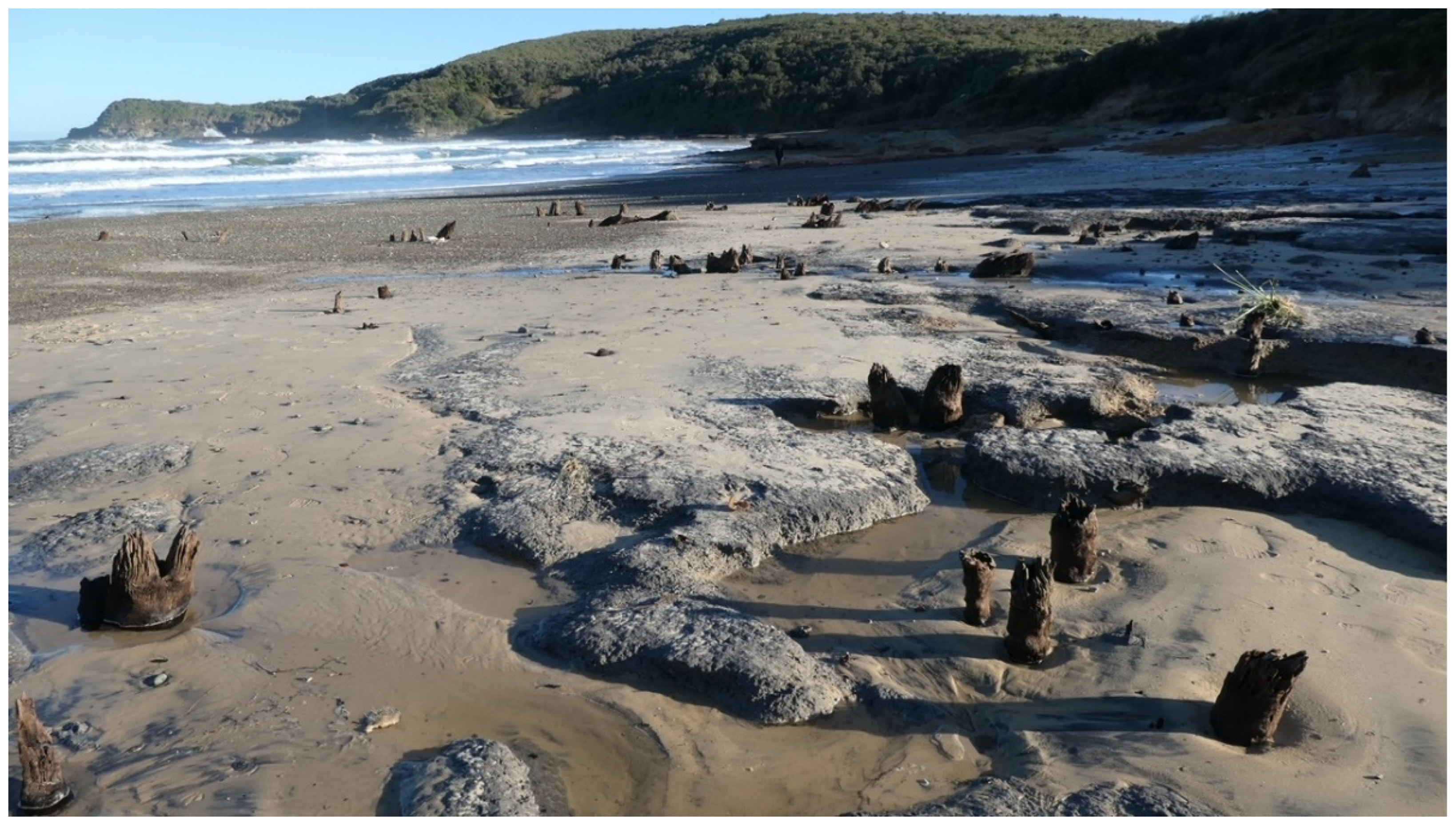
Figure 1. Unidentified remnant stumps at Frazer Beach within the Munmorah State Conservation Area in New South Wales, prior the sand returning to its natural state. This area is known for 250+ Ma fossil forest at Swansea Heads nearby (refer text for detail). Image supplied by Chris Morton (Vice President, Amateur Geological Society of the Hunter Valley).
Heritage 08 00256 g001
Figure 2. Conceptual model showing the record of submerged tree remains and their sedimentological-topographical traits as well as selected research devices for nearshore sampling (reproduced with permission from Kaiser et al. [6]; their Figure 7, CCC licence 1581826-1).
Heritage 08 00256 g002
Figure 3. GPR profile along the Baltic Sea beach in the village of Rybachy (reproduced with permission from Sergeev et al. [44]; their Figure 6). Coloured lines define inferred unit boundaries.
Heritage 08 00256 g003
Figure 4. Conceptual model of environmental evolution of palaeoforest site, including subfossil stumps along eroding shoreface, landward migrating barrier beach and dune system, stumps and preserved tree trunks in the high marsh environment and healthy forest along upper border (modified from Maio et al. [39]; their Figure 6).
Heritage 08 00256 g004
Figure 5. Skeleton of the dugong found at Shea Creek (left), and close up the ribs (right) showing cut marks (from Etheridge et al. [63]; their Plates XIa and XI, respectively).
Heritage 08 00256 g005
Figure 6. Holocene sea-level curve for SE coast of Australia, showing selected radiocarbon ages for peat and in situ wood samples (modified from Sloss et al. [40]; their Figure 5). Inset shows simplified diagram of the Etheridge sedimentary cross section with original defined strata (a–g), aligned against sea level (from Haworth et al. [41]; their Figure 5).
Heritage 08 00256 g006
Figure 7. Ancient tree stumps on the beach near the Warren river mouth (sourced from Oliver Berry, CSIRO). The large size of the stump suggests it may be a remnant of a tingle tree.
Heritage 08 00256 g007
Figure 8. New exposure of sub-fossil trees along Wharton Beach, June 2025, following erosion of a metre of more of sand.
Heritage 08 00256 g008
Figure 9. Photo of one of preserved tree stump exposed at Badger Beach (Image supplied to Australian Broadcasting Commission).
Heritage 08 00256 g009
Disclaimer/Publisher’s Note: The statements, opinions and data contained in all publications are solely those of the individual author(s) and contributor(s) and not of MDPI and/or the editor(s). MDPI and/or the editor(s) disclaim responsibility for any injury to people or property resulting from any ideas, methods, instructions or products referred to in the content.