Article

Triana: Unveiling Urban Identity and Dwelling Architecture in the Modern Era

by
Pilar Moya-Olmedo
1,* and
María Núñez-González
2
1
Graphic Expression Area, King Juan Carlos University, 28942 Madrid, Spain
2
Architectural Graphic Expression, University of Seville, 41004 Seville, Spain
*
Author to whom correspondence should be addressed.
Heritage 2025, 8(5), 182; https://doi.org/10.3390/heritage8050182
Submission received: 13 March 2025 / Revised: 25 April 2025 / Accepted: 9 May 2025 / Published: 20 May 2025
(This article belongs to the Section Architectural Heritage)

Abstract

:
During the Modern Age, Seville was known as the Port of the Indies due to its key role in transatlantic trade, although the actual port was located in Triana, a riverside quarter outside the city walls along the Guadalquivir River. This area was essential for maritime and commercial activities, shaping Seville’s economic and social development. This study analyses Triana’s urban layout, social composition, and architecture in the 16th century using historical sources and graphic representations. The quarter combined defensive structures, religious buildings, and residential complexes, reflecting both its strategic importance and distinct identity. Its streets and architecture supported defense, commerce, and daily life, while its diverse community (including sailors, merchants, craftsmen, and dockworkers) was central to its mercantile and manufacturing activity. Architecturally, Triana featured traditional dwellings, corrales de vecinos, mesones, and posadas, that facilitated trade and travel. Examining these elements reveals Triana’s adaptability to economic and social conditions, highlighting its resilience, diverse population, and rich architectural heritage within Seville’s historical context and Atlantic trade.

1. Introduction

1.1. About Seville

To understand urban planning on the Iberian Peninsula in the early Modern Age, it is essential to analyse two fundamental architectural and structural elements: the city walls and the church. These components, though inherited from medieval tradition, were integrated from the earliest phases of Christian repopulation and played a crucial role in the organisation of urban settlements. City walls not only provided protection but also structured the urban fabric, while churches acted as centres of social and territorial organisation. Together, they defined the growth of cities over time [1]. However, in a relatively short period, the consolidation of urban space led to the construction of buildings and the creation of new urban spaces. As these were integrated into an increasingly complex network, they became essential landmarks for the development of urban centres. This phenomenon of urban expansion and stratification occurred in many peninsular and American cities, contributing to their definitive transformation [2].
The city of Seville was certainly special, as it played a fundamental role in the urban and commercial context of the Iberian Peninsula. Its importance grew from 1503 onwards, with the establishment of the Casa de Contratación (House of Trade) which centralised trade and the administration of routes to the new overseas territories. This established Seville as the so-called Port of the Indies and the principal centre of trade with the Americas during the 16th and 17th centuries. Its strategic location on the banks of the navigable Guadalquivir River facilitated the arrival of ships from the Atlantic and enabled the distribution of goods to the interior of the peninsula. In addition, its position several kilometres inland offered protection from pirate attacks. These factors (combined with the expansion of port infrastructure and the establishment of the Casa de Contratación) made Seville the main centre for economic transactions between Spain and the Americas (Figure 1).
However, despite its growing importance in transatlantic trade, Seville maintained the same organisational structure that characterised most cities on the peninsula: an urban layout centred around its walls and religious temples. The urban morphology of the city was characterised by small buildings with narrow façades and notable depth, organised contiguously around major temples. This urban planning model favoured the creation of densely populated neighbourhoods within the walled enclosure. Meanwhile, peripheral areas and suburbs (though less compact) also underwent a process of densification, reproducing the centrality of religious temples, albeit with more marked differences and the incorporation of open spaces. It is also important to note that Seville’s historical evolution was strongly influenced by its Islamic heritage, which contributed to a more irregular and complex urban configuration compared to other cities that followed a more structured development model.

1.2. About Triana

Although Seville concentrated all the administrative functions of overseas trade, the real core of port activity was located in Triana. This quarter, whose occupation dates back to the Islamic period, was strategically located next to a fortress and one of the main access routes into the city. Over time, Triana evolved from a dispersed suburb into a consolidated neighbourhood with a well-defined identity. By the 15th century, Triana was already recognised as a puebla (a village) with its own church [4], and its population had grown significantly, encouraging the development of a more organised urban fabric. The district’s streets, originally laid out in a linear pattern parallel to the river, expanded progressively, giving rise to a dynamic urban nucleus with significant commercial activity. By the end of the 15th century, Triana had emerged as a key enclave within the city, formally designated as the collación (quarter) of Santa Ana de Triana [5] (Figure 2).
This study begins with an analysis of 16th-century Seville, drawing on historical sources to gain a deeper understanding of Triana (one of the richest and most populous neighbourhoods in the city). The aim is to answer key questions such as: what was the collación of Triana like, and who were its inhabitants? Ultimately, the goal is to define the characteristics of their dwellings.
The proposed work aims to offer a comprehensive view of the urban, social, and architectural development of Triana during the Modern Age, highlighting its role within the socio-economic structure of Seville and its relevance in Atlantic trade.

2. State of Art

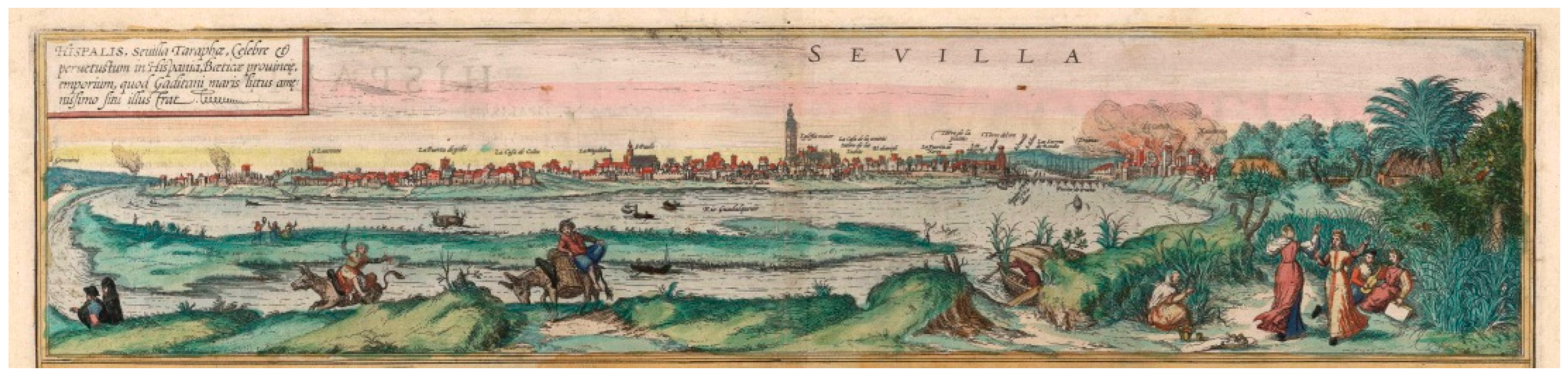
Regarding the images for the study of the urban planning of Seville and Triana in the 16th century, it is more than significant that from 1560 onwards, a production of graphic representations of the city began, mostly of a naturalistic nature, which marked a milestone in the history of Sevillian urban iconography. Except for the models of the main altarpiece of the cathedral, these representations are the first of their kind in the city and are fundamental visual documents for understanding the evolution of Seville’s urban landscape. Among the most outstanding works of this period are the panoramic views produced by artists such as Joris Hoefnagel (Figure 3) and Anton Van der Wyngaerde (Figure 4 and Figure 5), who captured the city in a precise manner, drawn from life. Another representative example of this graphic tradition is the print by Ambrosio Brambilla (Figure 6), produced in 1585, which presents a general panorama of Seville from the west, with Triana in the foreground. All these depictions not only offer a detailed view of the urban environment, but also give particular prominence to Triana, an aspect that is especially evident in one of Wyngaerde’s views. This is exceptional in that it shows Triana with a singular focus that underlines the importance of the neighbourhood in the context of the city.
These views are not only valuable as visual documents, but also as a means of exploring how artists of the time perceived and presented the urban development of Seville, with a particular focus on Triana. Their contribution to the study of the city in the 16th century is essential, as they offer a graphic perspective that complements other types of historical records and allows for a deeper understanding of the evolution of urban spaces, their organisation, and the relationship between the different neighbourhoods and the Guadalquivir River.
Also, among the main bibliographical sources for the study of urban representation in the 16th century, works such as La representación de la ciudad en el Renacimiento by Arévalo Rodríguez [11] or La imagen de la ciudad en la Edad Moderna edited by Cámara Muñoz and Gómez López [12] stand out. In addition, Ciudades del siglo de oro: Las vistas españolas de Anton van den Wyngaerde edited by Kagan [13], together with the facsimile editions of Civitates Orbis Terrarum by Max Schefold [14] and Skelton [15], are essential references. For the Sevillian context, the work of Díaz Zamudio and Gámiz Gordo on Sevilla [16] is fundamental and complements this perspective. Finally, Iconografía de Sevilla. 1400–1650 by Cabra Loredo and Santiago Páez [17], brings together many views of Seville.
The systematic analysis of Seville’s periphery was first addressed in Sevilla extramuros. La huella de la historia en el sector oriental de la ciudad, edited by Valor Piechotta and Romero Moragas [18]. Other relevant studies on 16th-century Seville include Historia de Sevilla. La ciudad del Quinientos by Morales Padrón [19] and El urbanismo de Sevilla durante el reinado de Felipe II by Albardonedo Freire [20]. Finally, the work by Gámiz Gordo and Barrero Ortega, Imágenes de un patrimonio desaparecido: la Puerta de Triana en Sevilla [21], is of particular relevance.
Likewise, the study of the city’s urban and rural infrastructures is complemented by works such as La obra hidráulica en la cuenca baja del Guadalquivir by Moral Ituarte [22]. Regarding fortifications, the Estudio histórico-arqueológico de las puertas medievales y postmedievales de las murallas de la ciudad de Sevilla by Jiménez Maqueda [23] provides a detailed analysis. In relation to the religious buildings found outside the city walls, Patrimonio y ciudad. El sistema de los conventos de clausura en el centro histórico de Sevilla by Pérez Cano [24] offers a complete perspective. On the other hand, Los hospitales de Sevilla by Chueca Goitia et al. [25] focuses on the hospital institutions of the 16th century. Finally, the study of the rural landscape of Seville is found in El paisaje rural sevillano en la Baja Edad Media by Montes Romero-Camacho [26].
For the analysis of the dwelling and urban structure of Seville and Triana, various documentary sources were consulted, including archives such as the Archivo de la Catedral de Sevilla Seville Cathedral Archive (ACS), the Archivo de la Diputación Provincial de Sevilla Provincial Council Archive of Seville (ADPSE), and the Archivo Histórico Provincial de Sevilla Protocolos Notariales Provincial Historical Archive of Seville Notarial Protocols (AHPSPN).
Particularly noteworthy are the surveys of houses, some of them with plans, which provide information on the tenants, trades, dimensions, and construction characteristics of the properties. More than a thousand surveys have been reviewed, including descriptions of houses belonging to the Cathedral and to the hospitals of Las Bubas, El Cardenal, and Las Cinco Llagas (16th-century surveys), as well as of the reduced hospitals (beginning of the 17th century, Amor de Dios and Espíritu Santo hospitals), many of which were illustrated by Vermondo Resta. In addition, other surveys of the hospital of Misericordia (17th century) have been included, allowing the identification of 44 properties in the collación quarter of Triana.
Apart from this documentation, chronicles and publications, such as Curiosidades antiguas sevillanas by Gestoso Pérez [27], Curiosidades sevillanas by Álvarez Benavides [28], Triana de puente a puente (1147–1853) by Acosta Domínguez [29], and Triana: el caserío. Calles, plazas, sitios y lugares by Macías Míguez [30], the latter based on the population lists of neighbours from the 15th century to the 19th century, have been reviewed.
Finally, the academic research of Díaz Garrido [31], whose thesis Triana y la orilla derecha del Guadalquivir was awarded the Focus-Abengoa prize in 2005, stands out. Her study on the residential typology of the corral de vecinos, a traditional Spanish communal house in Triana, and her coordination of the Aula Digital de la Ciudad have been fundamental to understanding the urban evolution of the neighbourhood [32].

3. Historical and Urban Context of Triana

The evolution of the urban form of Triana, when adjusted to the specific context of this article, can be divided into three stages. The first corresponds to the Islamic period, when the arrabal (a peripheral neighbourhood or suburb found outside the city walls) were typically inhabited by working-class residents, artisans, and marginalised communities. These districts often developed organically beyond the official urban limits and played a crucial role in the city’s economic and social life. This was followed by a late medieval stage, crucial for the consolidation of the historic arrabal, extending from the Christian conquest until the end of the 15th century. The third stage covers the 16th and 17th centuries, when the city, along with Triana, reached its peak—linked to the discovery of America—followed by a later period of economic decline. This chronological sequence is the relevant one for our analysis, leaving aside other traditional divisions of urban history.
In the first phase, the Islamic period, the foundations were laid for later growth, with Triana becoming a strategic and significant point in the urban development of the city of Seville. From this time onwards, Triana was intimately linked to the River Guadalquivir, the course of which defined its geographical importance and economic value. On the opposite bank to the Arenal, i.e., on the right bank of the river, the area most affected by the current, was the arrabal of Triana opposite the city. This urban proto-nucleus developed parallel to the riverbank, articulated by two main routes that were based on two different land roads: San Jacinto Street, as part of the road to San Juan de Aznalfarache, and Castilla Street, as an extension of the road to Castilleja de la Cuesta.
From this location, the territory of the arrabal extended northwards to the Monastery of Santa María de las Cuevas, westwards to Madre Vieja (the former course of the River Guadalquivir within the city), and southwards to the stretch of the river between Point of Los Remedios and Point of Tablada. This area, rich in fertile land and occupied by vegetable gardens and orchards, was known as the Vega de Triana. This flat landscape was crossed by paths that connected Seville, through Triana, with the nearby towns of the Aljarafe-Santiponce, Camas, Castilleja, Tomares, and San Juan (by a radial network of paths running north–south that crossed the river, and the plain in a transverse direction). This network was densified in the immediate surroundings of the arrabal by minor paths, used to access the many vegetable gardens.
To this geographical and urban description, we must add two fundamental elements in the original structure of the arrabal, which refer to its origin and its relationship with the location: the old Triana castle, next to the future bridge, today the Triana market; and the Cava, now Pagés del Corro Street, which corresponds to an Islamic moat that surrounded the suburb for defensive purposes. The presence of both castle and moat made the defence of Triana an exceptional case, since, although found in a suburb, they would have formed part of the defensive system of Seville.
As Valencia points out, until the 11th century, Triana must have been at most a small farm estate, beginning to grow from the time of the Taifas and reaching a greater extension in the Almohad period, when the capital overflowed the Almoravid enclosure and Triana was boosted by the boat bridge that extended in front of this neighbourhood, which made it an obligatory point of access from the Aljarafe [33].
From this time onwards, references to Triana as a village or recreational town began to appear in Muslim chronicles, and as an arrabal in Christian sources. A particularly relevant moment in this evolution was when Seville became the capital of the Almohad empire, and the construction of a pontoon bridge was ordered, inaugurated in 1171, a key element in the urban development of the suburb. There are also Arab references to the port of Seville, where constructions are described that extended along both banks of the Guadalquivir River, and, in terms of industry, it was when pottery activity in Triana began to be documented.
Although the arrabal had its origins in the Islamic period, it can be affirmed, e.g., by Díaz Garrido [31], that a second foundation of Triana took place during the late Middle Ages. The Christian conquest marked a new milestone in the town’s history with the construction of the church of Santa Ana and the creation of the town around it. This foundation must have responded, if not to a real need of the existing population, then to factors of a representative and defensive nature linked to the control of the port.
The late medieval period, from the Christian conquest of Seville in 1248 until the end of the 15th century, was crucial for the consolidation of the arrabal as a neighbourhood. At this time, Triana underwent a profound transformation. Its status as an arrabal was strengthened and it evolved into an urban centre with its own identity, even being recognised as a guarda y collación de Sevilla (guard post and quarter of Seville). The neighbourhood became important not only as a residential area but also as a commercial and productive enclave, acting as a strategic link between Seville and its immediate surroundings. In this context, Triana was a centre of craft, agricultural, and industrial activity, with a population whose economy was centred around the river, the cultivation of the land, and the dynamics of river trade.
After the conquest and the later process of repartimiento, Triana is often mentioned in historical sources. Its prominent role during the siege of Seville explains the frequent mention of the suburb in relation to two key elements in the defence of Seville: the castle and the bridge. Through the Libro del Repartimiento, and from the description of the vegetable gardens, the outline of the arrabal of Triana can be delineated, extending from the road to Sanlúcar in the north to the road to San Juan de Aznalfarache in the south. The Cava also appears in these descriptions, although without sufficient detail to characterise it. The last element mentioned in these sources is the almona (soap factory), the importance of which would later be consolidated.
Starting from the oldest and most structuring element of the arrabal, the current Castilla Street predates both the bridge and the castle. The plan of the new town must have been based on an elementary layout articulated around three main components: a street laid out along the main axis, a square, and a church, forming a longitudinal layout.
This new urban organisation was based on an unpopulated territory, although conditioned by the existence and limits of the Islamic arrabal. The main street, the axis of the settlement, was arranged tangentially to these limits, around the castle, but without showing direct continuity with the earlier routes. On both sides of the main axis, built-up strips of different widths were arranged, determined by the proximity of the river on one side and the presence of the church on the other. The planning of this built-up strip, characterised by a regular distribution of transversal streets and plots, could be interpreted as evidence of an interest in generating a continuous image of the front of the town that was visible from Seville.
In this sense, the construction of the church of Santa Ana and the shaping of the town around it are undoubtedly the most significant event in the urban development of this period. It is worth noting the fortified nature of the original church, of which traces remained until the 18th-century renovations, when the church lost its crenellated features [31].
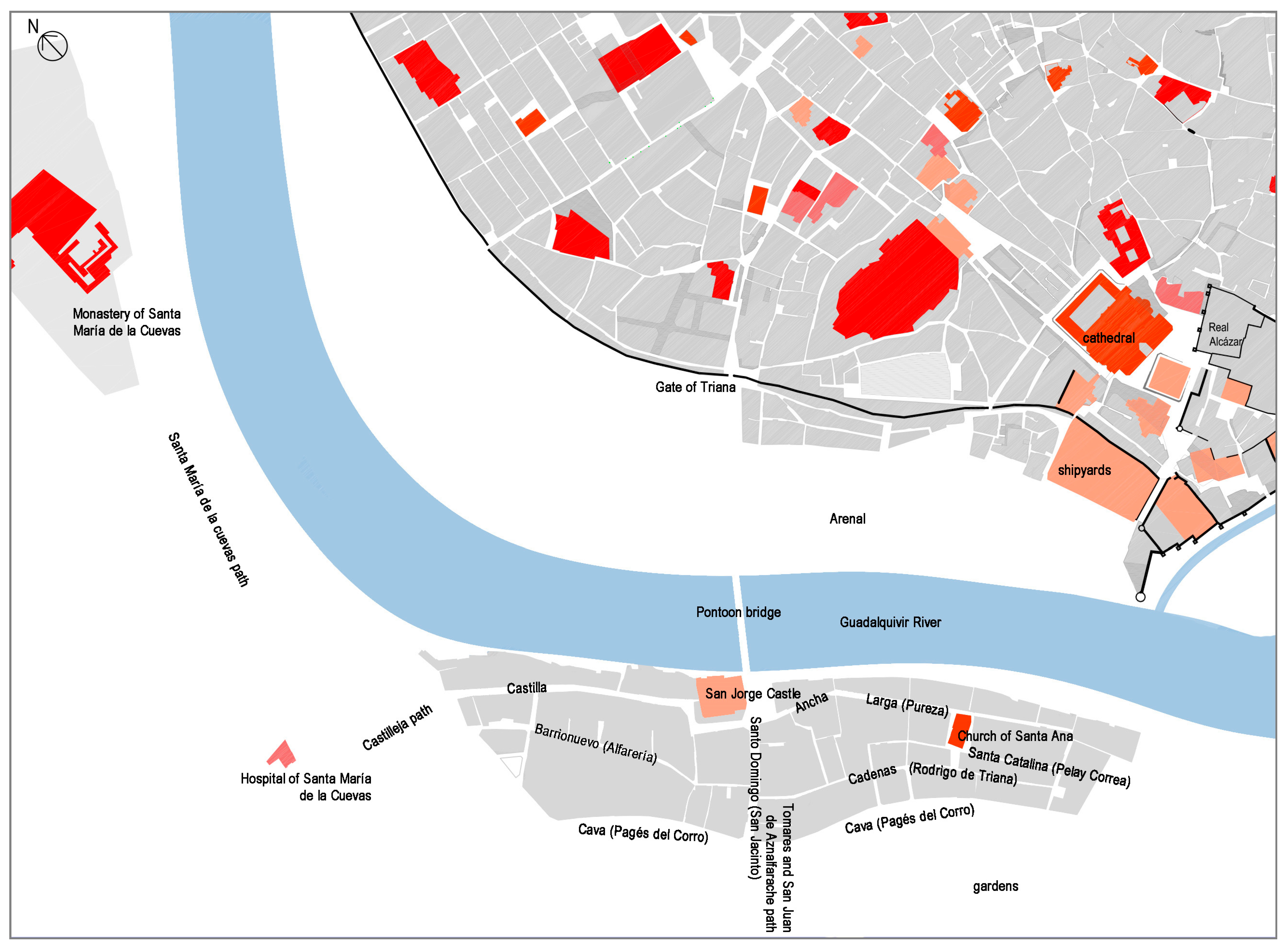
At the end of the 15th century, Triana experienced greater growth than the rest of the city, driven by its privileged location next to the port and by the boom in its industry, especially ceramics. In this context, a more spontaneous settlement appeared on the Cava, which acted as a structuring element. Two main sectors were formed on either side of San Jacinto Street which began to play a new role as an urban boundary. The church of Santa Ana and the associated village were consolidated as the nerve centre of the neighbourhood, around which later growth would be concentrated. This expansion tended towards the south, favoured both by the location of the different port docks and by the appearance of dwellings also on the other side of the Cava (Figure 7).
During the 16th and 17th centuries, Triana experienced a period of splendour, driven largely by the discovery of America and the subsequent boom in trade with the Indies. As Morgado points out, by the end of the 16th century, Triana had become a key warehouse for goods such as tar, nails, oars, and various equipment for navigation [34]. This underscores not only Triana’s significance in maritime and commercial activities, but also the growing prominence of sailors, captains, and shipmasters who settled in the area, drawn by the economic opportunities stemming from the port’s dynamic role. This connection to the maritime world was further reflected in local industries producing goods essential for navigation, such as gunpowder, biscuit (a staple food for crews), and ceramics, much of which was destined for transatlantic trade [35].
The fluid connection between Seville and Triana through the Pontoon bridge was essential for the exchange of goods and people, complemented by a road network linking the neighbourhood to surrounding territories on the Iberian Peninsula [36]. Industry and commerce played crucial roles in Triana’s growth, consolidating the neighbourhood as both a production hub and a strategic point for trade routes extending both across the peninsula and to the Americas.
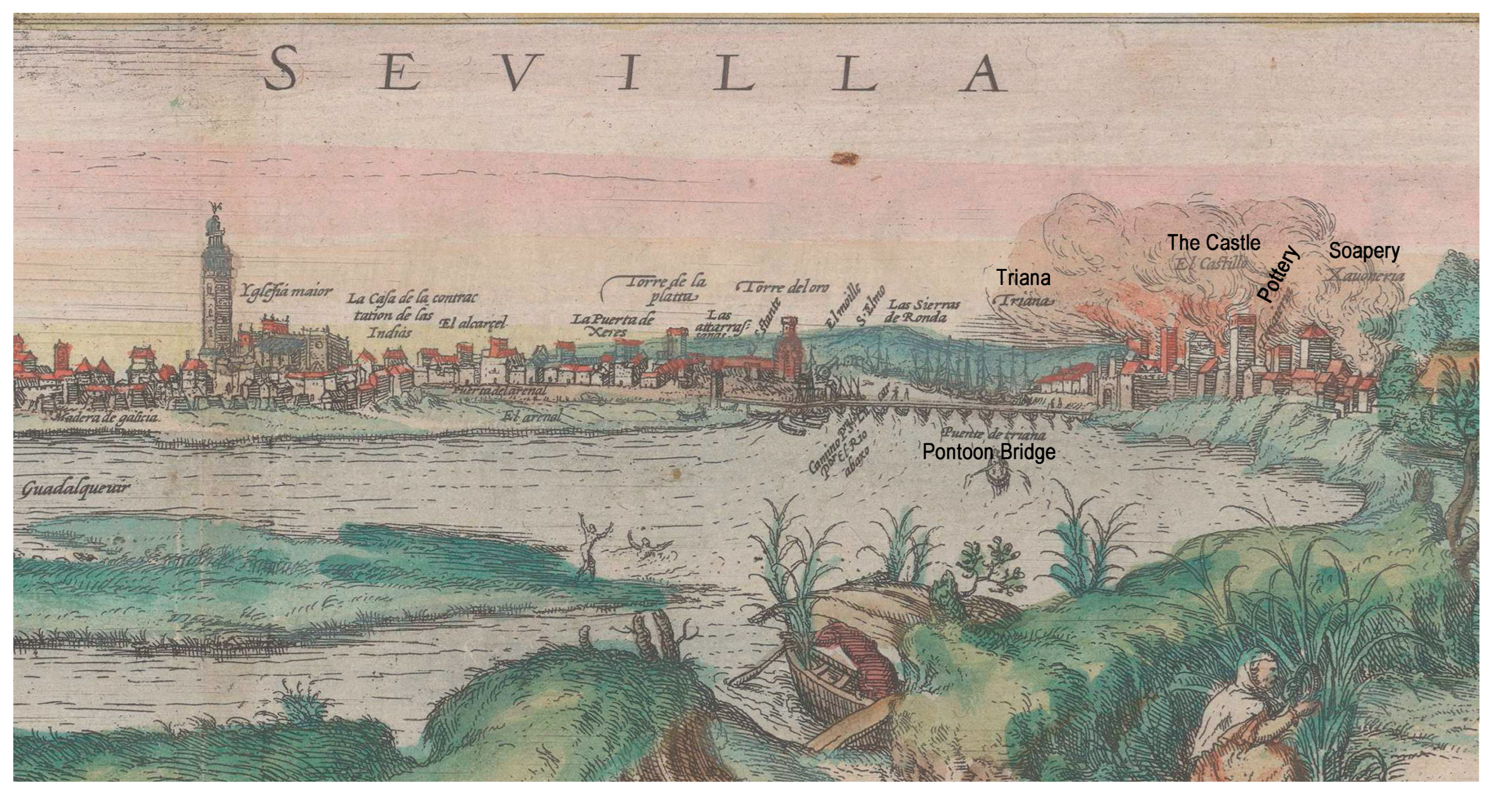
Fully integrated into the urban life of Seville, Triana gradually developed a reputation as a populous, industrial suburb, known for its potters and sailors. Its privileged location by the river enabled the development of infrastructure and industries typically not found in the city’s interior, such as secondary docks, shipyards, and factories. Notably, the neighbourhood became home to traditional industries like soap-making and pottery, as well as newer ones, including gunpowder mills for the Navy. The location of these mills near the port was strategic, although they had to be relocated several times due to explosions (Figure 8).
In addition to its port and industrial function, Triana was home to other important institutions. One of the most outstanding was the seat of the Tribunal of the Holy Office, installed by the Catholic Monarchs in the castle of Triana from 1481 onwards. In 1569, the Universidad de Mareantes (University of the Men of the Sea), heir to the medieval Colegio de los Comitres (School of the Shipmen), was founded as a reference point for seafaring professionals. This university brought together the sailors, masters, and pilots who formed part of the structure of the maritime trade to the Indies. The university was present in Triana until the end of the 17th century, in the building where the Casa de las Columnas (House of Columns) stands today.
Economic growth brought with it a considerable demographic increase. At the end of the 16th century, Triana had an estimated population of 4000 inhabitants, a figure that, according to estimates, would be equivalent to around 20,000 today. In this context, more than 2500 houses were built in Seville, of which more than 900 were in Triana [38]. This dynamism was also reflected in the religious and welfare sphere, with the founding of many convents and hospitals motivated by the populous nature of the neighbourhood. In the 16th century, the convents of Santa María de la Victoria, Espíritu Santo, Nuestra Señora de la Consolación, and Nuestra Señora de los Remedios were founded, and in the 17th century, the Convent of San Jacinto. Except for the Espíritu Santo, all of them were outside the limits on the other side of the Cava. There was also a proliferation of hermitages and chapels, such as those of San Sebastián, Los Mártires, La Encarnación, and La Candelaria, and small-scale hospitals associated with them, the most important of which were the hospitals of Santa Ana and Santa Catalina (Figure 9).
Triana was in constant interaction with other communities, especially with the Portuguese. According to Morales Padrón [19], the Portuguese presence was notable, and the cooperation between Castilian and Portuguese sailors played an essential role in Atlantic expansion. This alliance favoured commercial exchanges and consolidated Triana as one of the most important seafaring districts on the peninsula. Urban expansion was also influenced by the arrival of new settlers, such as the Moors expelled from Granada by Philip II. At the end of the 16th century, it is estimated that the Moorish population in Seville reached 7000 people, many of whom settled in Triana, significantly influencing its social and cultural composition.
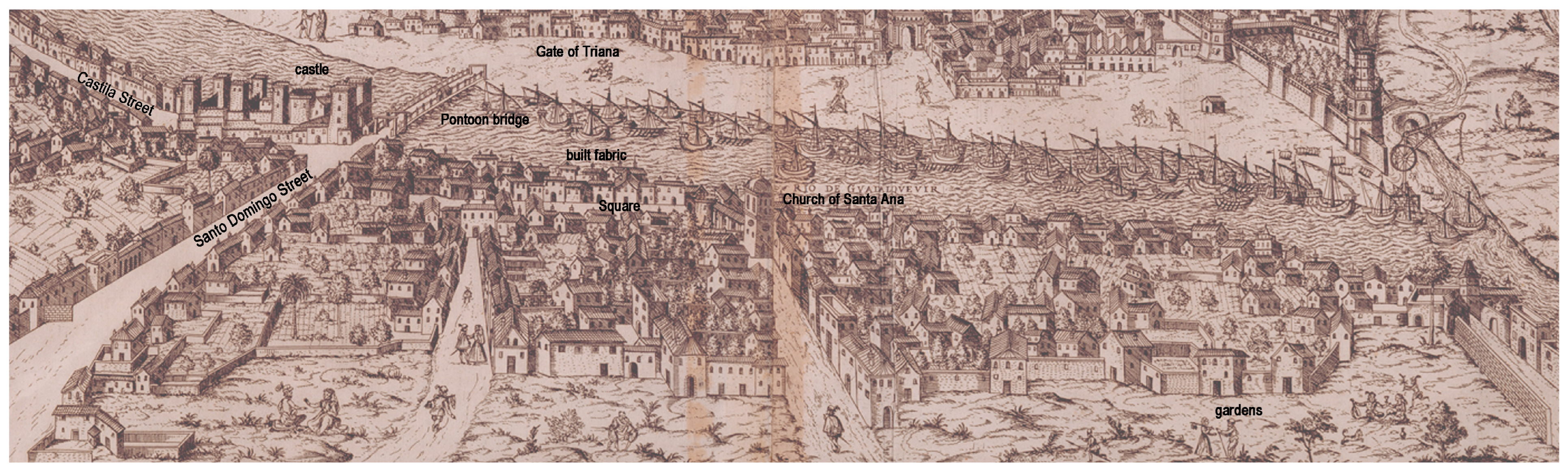
This notable urban and functional growth led to a profound transformation of Triana, although no specific records of planning initiatives have been preserved, as is the case with Seville. The only documented interventions correspond to the attempt to replace the Pontoon Bridge (Figure 10) and the proposal by the Count of Salvatierra in 1615 to provide Triana’s dwellings with marble arcades [31]. The urban morphology of Triana would be characterised from this time onwards by a complex grid made up of houses, corrals, shops, and inns, especially concentrated from this time onwards in Altozano or Santo Domingo Street, the names given to what is now San Jacinto Street from the Pontoon Bridge to the Cava until the 19th century. Commercial and industrial activities also took place in the neighbourhood [30,37].
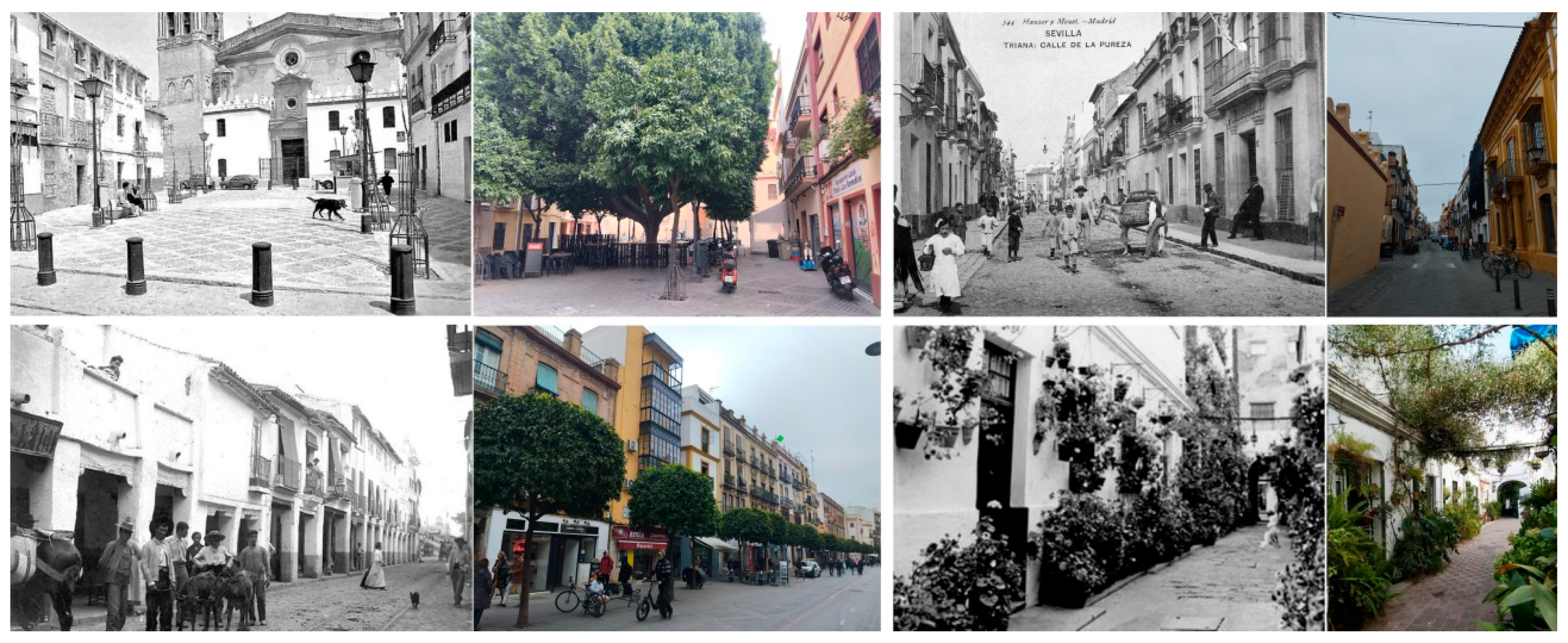
There was also an expansion towards the area of the orchards, with new streets appearing from old paths, as well as the extension of Castilla Street beyond the Cava Vieja. Ultimately, this urban and social landscape of Triana, shaped by its ties to commerce, industry, the sea, and the routes to the Americas, reflected an interdependence of elements that contributed to its consolidation as a key neighbourhood in the history of early modern Seville.

4. Neighbours: Occupations and Backgrounds

As has been observed since the late medieval period, the population of Triana had been distinguished by its notable diversity of trades, a reflection of the economic and social structure of the neighbourhood. According to historians, Trianeros were engaged in activities linked to the sea, agriculture, and industry. Among the most widespread traders were sailors, who played a fundamental role in maritime traffic to the Indies, as well as builders and craftsmen, who were essential to producing elements necessary for navigation and daily life. In fact, Triana was a centre for the manufacture of items such as pottery, soap, gunpowder, and biscuit, products that were closely related to the expeditions and trade to America. In addition, the area surrounding the neighbourhood, rich in vegetable gardens, allowed agriculture to flourish, with the production of oil and wine, activities that were fundamental for the supply of the city and foreign trade [40].
Along with these trades, the population of Triana was also made up of potters and other craftsmen who carried out work related to local production and trade. These trades were essential for the supply of basic products and the creation of utensils used in everyday life. In addition to these workers, Triana also housed servants, people dedicated to various domestic and support tasks, as well as professionals from different fields, such as doctors, apothecaries, and clergymen [19]. The latter constituted an important part of the community, as they played significant roles in both the religious life and public health of the neighbourhood (Figure 11).
An analysis of the documents of the surveys studied, which describe the properties and the conditions of the tenants, confirmed the variety of professions in the neighbourhood. In these texts, the occupation or social status of residents is often mentioned, allowing us to see a wide range of trades, from the humblest to the most prestigious. Among the tenants recorded are potters, labourers, sailors, and merchants, highlighting the economic versatility and the importance of manual and commercial work in the development of the neighbourhood. Married couples, widows, and a considerable number of married women, who were an active part of the community, also stand out. It is interesting to note the presence of Portuguese among the residents, which is consistent with the research of Quiles García et al. [40], who underlined the significant Portuguese influence in Triana during the 16th century, especially in the maritime sphere.
The surveys also mention other professions that formed part of everyday life in Triana. Among them, the following trades are documented: atahonero (flour mill worker), apothecary, ship captain, clergyman, doctor, farrier, ship master, pilot, merchant, and oil merchant, which once again shows the diversity of economic activities and the social plurality that existed in the neighbourhood. This professional diversity and the presence of people of different origins and social status constitute one of the most defining characteristics of Triana currently, reflecting its complexity as a meeting place for diverse social, ethnic, and economic groups (Figure 12).
This panorama of diversity in the social composition of Triana highlights how the neighbourhood was not only a hub of economic activity, but also a space where diverse cultures and social groups coexisted. The coexistence of sailors, artisans, merchants, and workers of different trades, together with the influence of foreign populations, contributed to giving Triana its unique character within 16th-century Seville. This complex social structure allowed the neighbourhood to become a vibrant centre of production, trade, and culture, comprising a fundamental pillar of the city in the context of the economic boom linked to trade with the Indies.

5. The Houses of Triana: Structure, Uses, and Distribution

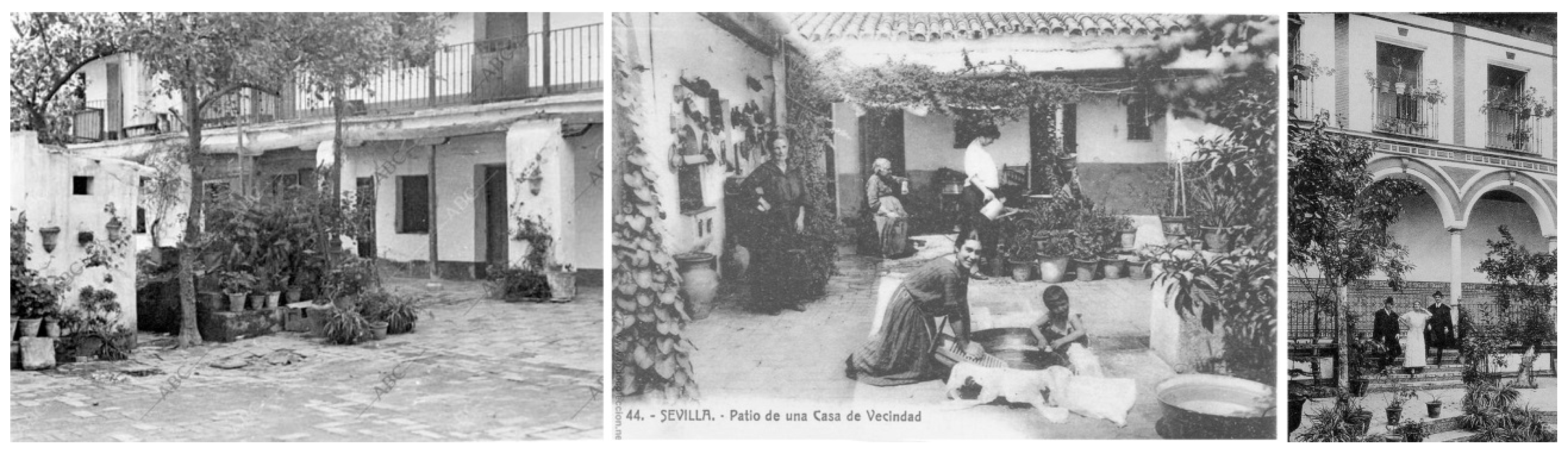
Study of the dwellings of Triana, based on 44 analysed surveys, showed a notable variety in the types of constructions that predominated in this Sevillian neighbourhood. Most of the buildings were residential in character, although some other uses were documented, such as a corral that served as an orchard, a corral de vecinos, and a shop. To better understand these spaces, we integrated data from other publications and chronicles that show tenement houses and corrales de vecinos as the most common architectural typologies in Triana. These corrals and dwellings were not only residential, but also an integral part of a way of life that, due to their proximity to the city, was linked to commercial and service activities. In addition, the presence of inns suggests that Triana, being a neighbourhood outside the city walls and at the confluence of several roads, was a place of transit and rest, which favoured the formation of this type of establishment (Figure 13).
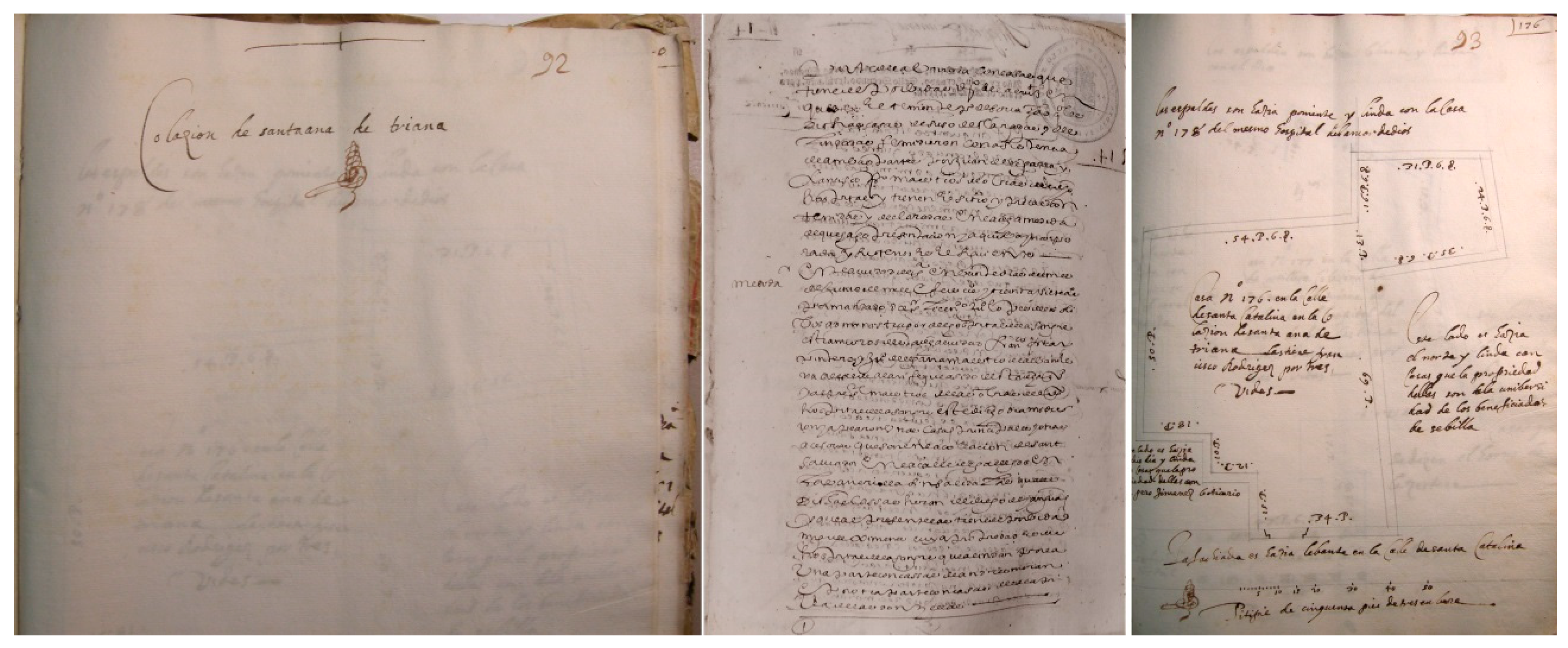
Our analysis of the Triana dwellings was based on 33 literary and 11 graphic surveys, which offer a detailed view of the surface area and distribution of the houses (Figure 14). The literary surveys use Castilian yards (0.8359 m) to measure the width and length of the spaces, allowing the surface area of each room on the ground floor to be calculated. Once these measurements had been obtained, the occupied area of the plots was estimated by adding 10% to the total surface area of the dwellings to provide a more accurate approximation. The graphic surveys also provided a visual scale, which allowed the exact conversion of the measurements to square metres using a CAD programme (AutoCAD 2026).
Considering the aims of this research, several features of the survey texts and drawings can be identified. These documents serve as valuable sources for graphic representation due to their descriptive richness; they provide relevant data for urban studies by offering information on streets, neighbourhoods, and specific locations; they allow for the analysis of building uses, often including detailed descriptions; and they also contribute to the enrichment of technical and architectural vocabulary.

Architectural Drawing and Analysis

Over the course of our research, we developed a method aimed at incorporating a historical–archaeological perspective into the study of architecture. This approach relied not only on the analysis of abundant written sources and the more limited graphic documentation available, but also (when accessible) on the study of material and archaeological evidence. From an architectural standpoint, historical and archaeological knowledge has always been considered essential to fully understand and contextualise built forms.
Applying this method, 18 of the 19 dwellings analysed were graphically documented. These graphic surveys made it possible to delve into the study of domestic typologies in the Triana neighbourhood during the 16th and 17th centuries.
The procedure used to represent these buildings was based on the formulation of hypotheses regarding their floor plans, elevations, sections, and volumes. This hypothetical reconstruction provided a better understanding and allowed us to undertake an architectural analysis of the structures through a process that could be defined as a ‘translation from the literary and graphic into the digital’.
The work was carried out in several phases. The first stage involved locating, selecting, and then transcribing the documentary sources that would form the basis of the study. Once the archival work was completed, the second stage consisted of inputting the data into digital software to allow for further analysis, graphic reconstruction, and the cataloguing of the dwellings.
More specifically, the methodological process of digitising and analysing the constructions described in the surveys included the following steps:
  • Search, identification, and selection of the surveys and other documentary sources relevant to the study of Triana’s dwellings.
  • Study and classification of these sources to determine their reliability and usefulness.
  • Transcription of the survey texts in detail.
  • Digital processing of the data, entering the information into specialised software to organise the general data and select only what was necessary for understanding the architecture, construction, and formulation of drawing hypotheses.
  • Digital drawing of the buildings based on the survey descriptions.
  • Architectural and graphic analysis of the resulting representations, including both plan and volumetric aspects.
After the analysis, conclusions were drawn that covered the most frequent volumes and the relationship of the buildings with the street, such as the distributions, the uses of the spaces and their surfaces, as well as the most recurrent types of construction and the installations inside them.
Our analysis of the data from these surveys revealed that the average surface area of housing plots in Triana was around 200 square metres, which is higher than the average for Seville, which was approximately 160 square metres [37]. This suggests that, compared to other areas of the city, Triana offered more spacious dwellings, which is consistent with the demand and commercial character of the neighbourhood.
In terms of the number of floors, most of the houses in Triana were not very tall. Single-floor dwellings predominated, although some exceptions were documented in the areas near the Altozano or Ancha Streets, which were areas with greater commercial activity. Some dwellings of greater surface area and construction quality were also found, which had more than one floor. In all cases, with one exception, the dwellings had a courtyard or a corral, or even both. These open-air spaces were essential for Triana dwellings and represented a characteristic element of the architecture of the neighbourhood.
Among the most common elements in Triana dwellings were casapuerta (vestibule), doorways, kitchens, and courtyards. Compared to the Seville average, Triana had a greater number of doorways, suggesting that the dwellings had multiple passageways that could have other uses. A kitchen, on the other hand, was present in almost 40% of Triana dwellings, compared to 25% in the rest of the city, which could show a difference in the habits and needs of the neighbourhood’s population. In many cases, the houses that did not have a proper kitchen had a space in the casapuerta, the doorway or the courtyard, where a fireplace was situated, or a cooker was installed for the preparation of food.
The living spaces in Triana’s houses were the so-called ‘palaces’, or living and sleeping quarters. The average number of these spaces was two per dwelling, which coincided with the general pattern in the city. However, given that many of the houses did not have soberados (extra spaces on the upper floor), it is possible that the Triana dwellings had a smaller area devoted to rooms compared to the rest of Seville. It is important to note, however, that the courtyards and corrals were fundamental elements in the structure of Triana’s dwellings. In fact, corrals, with larger surfaces than courtyards were more common than in other areas of the city [42] (Figure 15).
In terms of facilities, dwellings in Triana did not always have a well, unlike in other parts of Seville, where this resource was more common. Only 70% of the dwellings analysed had one, which could be due to the proximity to the Guadalquivir River or to an alternative supply system not yet detailed in the documents. For water drainage, some dwellings were equipped with drains, and for sanitation, latrines were used.
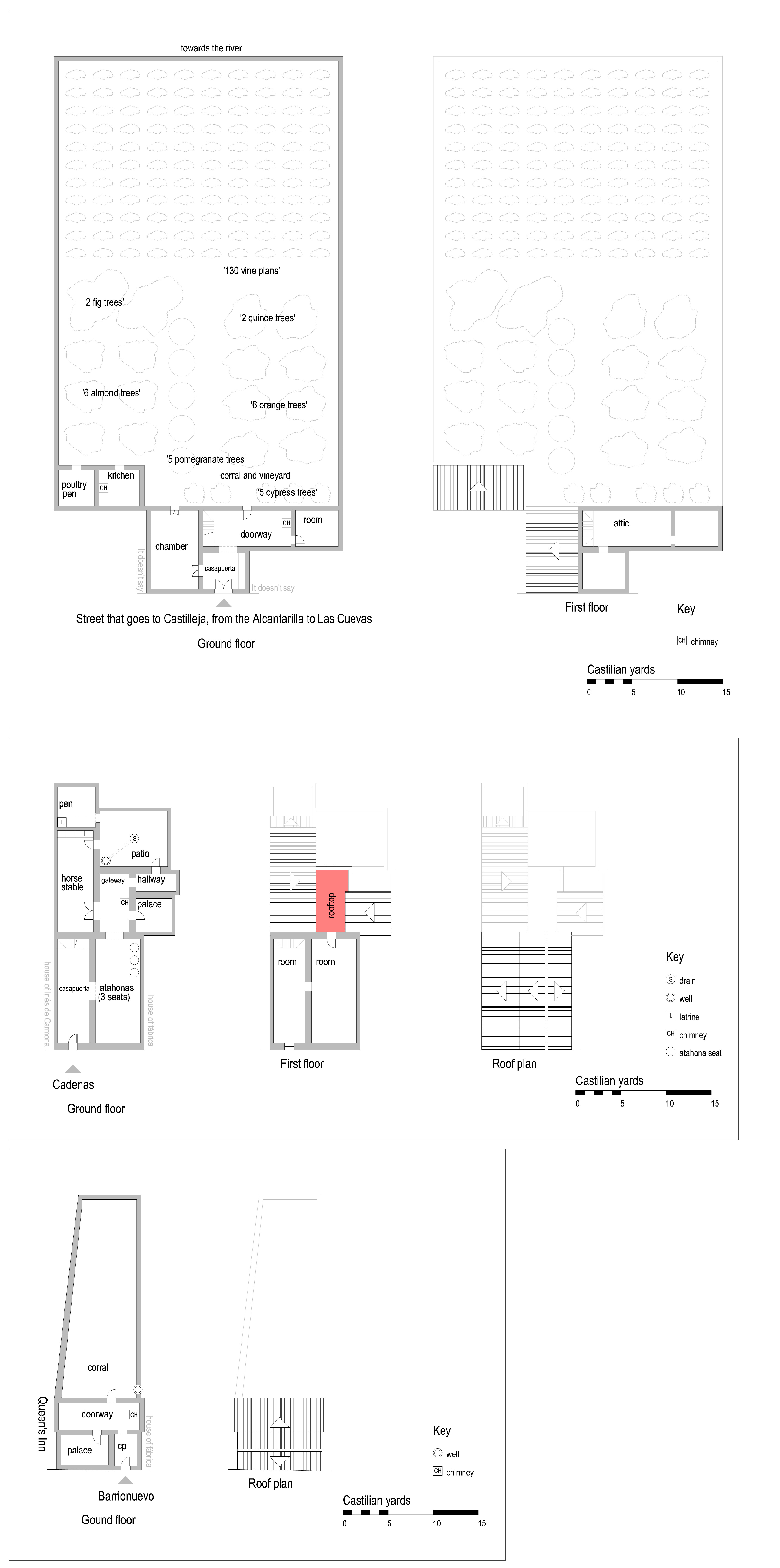
To better illustrate the diversity of typologies and uses, three representative dwellings were selected: a house with a large orchard and vineyards, a house with three atahonas (stone mill seats), and the house of a widow (a cook in a nearby inn). This variety of uses and configurations proves how, in Triana, the dwellings and especially the neighbourhood corrals not only fulfilled residential functions but also commercial and service functions. This trend continued even into the 20th century, when the corrales de vecinos continued to share spaces with industrial and commercial activities [43] (Figure 16).

6. Other Forms of Inhabitation: Corrales de Vecinos, Mesones, and Posadas

6.1. Corrales de Vecinos

The corrales de vecinos were a residential typology characterised by the construction of dwellings on interior plots, which were often occupied vegetable gardens or courtyards (called compases in Seville). In most cases, these dwellings were organised with a corridor of rooms attached to the boundaries of the plot. This type of dwelling was extensively documented for the whole of Seville in the 16th century, with 27 corrales de vecinos in total, of which two were in Triana [32]. However, for this study, the period of research was extended, using various documentary sources and notarial protocols that allowed the discovery of two more corrales in the 17th century.
During the 18th century, the proliferation of corrales de vecinos was remarkable, and their study has become a field of interest for many historians, among whom Macías Míguez [30] and Morales Padrón [19] stand out. The latter focused his attention on the gradual disappearance of the corrales in the 20th century, a phenomenon that had already been pointed out by other authors. In addition, the research by Fernández Salinas [43] on the historical heritage of Seville and the work carried out by Díaz Garrido and her team at the Aula Digital de la Ciudad [32] have contributed significantly to the knowledge of this typology. In their research, they documented 30 corrales that were still preserved in 2010 in various streets of Triana, such as Alfarería, Arcilla, Bernardo Guerra, Betis, Castilla, Covadonga, Pagés del Corro, Pureza, Salado, San Jacinto, and San Jorge.
An analysis of the corrales in the 16th and 17th centuries revealed a diverse distribution in their location. However, no clear conclusion can be drawn about the most common locations of corrales, because they were not a widespread residential typology at the time. The available data suggest that the corrales were concentrated in the Castilla, Santo Domingo streets (now San Jacinto), and the Cava (now Pagés del Corro). Among these, the Corral de La Parra, found in Santo Domingo, stands out especially, as it stayed in operation until 1880, having been founded in the 16th century.
The corrales were built around a central courtyard. In general, the men worked outside the dwelling, while the women and children remained in the courtyard. They usually had a kitchen equipped with a fireplace, a water well (later replaced by a tap), a washing area (with a basin), and a latrine. This living configuration remained unchanged until well into the 20th century, with the gradual incorporation of more modern technologies, but without significantly altering the spatial and constructional structure.
During the 18th century, the corrales and the casas de vecindad underwent significant expansion. Some of the areas that were most densely occupied by these housing spaces were the streets the Cava (Pagés del Corro), Barrionuevo (Alfarería), Castilla, Santa Catalina (Pelay Correa), Cadenas (Rodrigo de Triana), Santo Domingo (San Jacinto), and Larga (Pureza). Of all of these, Cava Street was notable for its large concentration of corrales de vecinos, especially during the height of gypsy trade in the 18th century. This boom made the street one of the most overcrowded, reaching its peak of population around 1950. Among the known corrales in the Cava Vieja were de Judíos, de Esparto, de Navarra, de Juan Ruiz, and de Platero, all of which are documented from 1706 in the population registers. In the Cava Nueva, other corrales were found, such as those of de Aromo and de Encarnación, referenced between 1705 and 1706 [30].
Other streets that housed many corrales were Barrionuevo, Castilla, and Santa Catalina. In Barrionuevo Street, there were outstanding corrales such as La Bomba (also known as La Casa Grande), del Túnel, where tiles, and flowerpots were made, and Largo, among others. Castilla Street, on the other hand, was famous for having several corrales and pottery kilns, such as the Corral Verde, el Hondo, del Facundo, del Padre Santo, de la Cruz, and de Mateos, among others, according to records from 1705. In Santa Catalina, known for its high concentration of corrales and industries, de Doña Mensía, del Moral, and del Parra were documented.
In other areas, such as Cadenas, important corrales were documented, such as those of de Penitencia, Los Palos, and Casa de las Atarazanas. San Jacinto, despite being an eminently commercial area, also housed several corrales, including de la Piedad (1705), del Parra (disappeared in 1880), and de Escalante. Finally, in Ancha and Larga streets, some corrales de vecinos were found, such as the Casa-horno de la Secretaría and el Haza de Sra. Santa Ana [30].

6.2. Mesones and Posadas

One of the most prominent residential forms in Triana, especially for those who passed through the city or stayed temporarily, were the mesones and posadas. In 16th century Seville, a clear architectural and functional distinction existed between these, while in English, the term “inn” encompassed both concepts. Mesones provided both food and lodging, often catering to transient travellers and merchants. These establishments were typically organised around a central courtyard, where stables and storage spaces accommodated guests travelling with goods or animals. In contrast, posadas offered more stable lodging for long-term residents or regular visitors, with a greater emphasis on private rooms and communal areas. This differentiation reflects not only variations in urban hospitality services but also distinct architectural layouts within the city’s built environment. The English term “inn” does not capture these nuances, as it historically referred to establishments offering both lodging and meals without necessarily distinguishing between their architectural structures or primary clientele.
The number of these establishments was significant in the 16th century, with around 70 inns registered throughout Seville, of which four were in Triana [44]. These inns were concentrated in the access areas to the city, particularly in the streets near the entrances to the roads that connected Triana with other towns. In particular, the most commercial streets of Triana, such as Castilla, Santo Domingo, and Barrionuevo, were the main locations of these establishments.
Macías Míguez’s exhaustive study of the streets of Triana also documented several inns on these same streets. In Barrionuevo Street, the Mesón de los Amoladores, which was in operation until 1900, stands out. In Castilla, there were the inns de Las Cuevas, de Las Bocas, de La Concepción, and the Posada Nueva or Posada de Don Juan y del Duque. In Santo Domingo, the inns de Cotarros, de la Gallega, and de Las Ánimas were recorded, which continued to operate until 1940 [30]. These places not only provided accommodation but also served as meeting places, particularly in the context of the commercial and transit flows of the time.
One of the most important inns, according to documentary sources, was the Mesón de la Reina, found in Barrionuevo Street. This inn was located next to a house rented by a widowed woman, which belonged to Seville Cathedral. Curiously, municipal ordinances prohibited the sale of food in the inns, so it was often the women who oversaw cooking for the inn’s customers. This type of activity was not exceptional, and it is highly likely that this was the case with Juana Fernández, who oversaw the preparation of meals in this establishment.
Despite the wealth of documentation on the inns in Triana, no specific survey plans have been found for them, which prevented us from creating a detailed graphic reconstruction of their structures. However, their organisation can be inferred from the common characteristics of the inns in Seville [45]. These spaces were made up of a large gatehouse that gave access to the dwelling, stables that occupied a third of the total surface area, and a courtyard or corral that accounted for another third of the space. In addition, the inns had rooms and guest quarters and sometimes included wells, water basins, and latrines. For the accommodation of horses, suitable stables were provided. This architectural model reflected a functionality oriented towards both lodging and added services, such as animal care and the provision of food and drink for travellers, and constituted a key element in the urban life of Triana during this period.
The prevalence of inns in Triana, as in other areas outside the city walls, underlines the importance of the area as a meeting point for travellers, traders, and temporary residents, which eased not only economic exchange but also the integration of different urban activities in a context of great social dynamism.

7. Current State of the Houses in Triana

Images and survey documents constitute a fundamental source for the study of Triana’s modern history, both for their descriptive richness and for the level of detail with which the masters depicted the buildings in their drawings and writings. In the specific case of the surveys, these documents not only provide a quantitative view of the buildings but also allow for their classification, offering a deeper understanding of their architectural characteristics and historical context. For this reason, the texts and drawings within the survey documents (when preserved) serve as authentic repositories of information, containing valuable data on the life cycle of the buildings and the people who inhabited them over time (Figure 17).
The architecture reflected in these documents holds significant heritage value and should have received appropriate protection. However, the persistent difficulty in locating, identifying, and preserving these buildings has posed a major obstacle to their safeguarding. Today, new research tools and methodologies offer the potential for a more comprehensive understanding of these architectural assets, which can significantly contribute to their conservation, restoration, or at the very least, accurate documentation. Nevertheless, any such effort must be grounded in precise knowledge derived from documentary sources that encompass not only graphic and textual evidence but also historiographical analysis.
The principal aim of this research was to provide fresh insights into the historical and architectural context of the Triana district at a key moment in its development, while also contributing to the wider field of architectural studies, particularly concerning 16th-century domestic architecture. Reconstructing this architectural past through historical documents presents a considerable challenge, given that the majority of the buildings recorded have since disappeared (Figure 18).
Nevertheless, wherever possible, efforts have been made to locate the original sites of these buildings and to analyse any surviving remains. In many cases, the absence of physical structures only reinforces the importance of preserving the available documentation, which stands as the primary testimony to a lost architectural heritage and serves as a vital key to understanding its role in the urban history of the city (Figure 19).
This article has presented a systematic compilation of the sources of information employed, along with a methodological approach developed over years of dedicated research. This framework has helped to overcome many of the inherent challenges in reconstructing Triana’s historic architecture, offering a solid foundation for future investigations and actions aimed at conserving architectural heritage.

8. Conclusions

Living in Triana fostered a profound sense of belonging among its residents. The inhabitants, known as trianeros, saw themselves as a distinct community, clearly differentiated from the sevillanos and people from other regions. This strong local identity was deeply rooted in the rich diversity of trades that thrived in the neighbourhood during the 16th and 17th centuries, shaping Triana’s unique character. Among its residents were sailors of various ranks and social backgrounds, potters, builders, farmers, livestock breeders, and workers involved in industries such as ceramics, soap-making, and gunpowder production. The social fabric of the area also included servants (especially in wealthier households) and Moors, both of whom played an integral role in daily life (Figure 20).
From an urban planning perspective, Triana was characterised by a dispersed settlement pattern, with modest houses scattered across the neighbourhood. Larger plots were found on the outskirts, while the central core, particularly along major streets such as Altozano, San Jacinto, Pureza, and Castilla, had smaller plots. The residential typology in Triana predominantly consisted of single-family homes, although a considerable number of tenement houses began to appear, particularly in the 18th century. Despite the historical presence of inns, they were not common dwellings for trianeros, who typically lived around these establishments, often managed by innkeepers (Figure 21).
Architecturally, Triana’s buildings resembled those of Seville in many ways, yet several distinguishing features set them apart. Notably, the buildings in Triana were lower in height, with single-storey homes being the most prevalent. Additionally, the plots in Triana were generally larger compared to those in Seville. Some, but not all, dwellings had wells, and the layout of outdoor spaces was markedly different, with corrales de vecinos often occupying more space than the dwellings’ courtyards. This reflects the importance of outdoor common areas in everyday life in the neighbourhood (Figure 22).
Triana’s resilience (as defined by the Royal Spanish Academy, i.e., ‘the ability of a living being to adapt to a disturbing agent or an adverse state or situation’) was clearly visible in its evolution. The neighbourhood adapted over time to the changing needs and challenges of its inhabitants while keeping its sense of identity. This resilience manifested not only in its social and professional diversity but also in its unique urban and architectural layout. While it shared common traits with Seville, Triana’s distinct characteristics solidified its identity as a place where community spirit thrived, shaped by its history, traditions, and ongoing adaptation to its residents’ needs (Figure 23).

9. Triana Empty of Trianeros… the Future

The Triana neighbourhood, an emblem of Sevillian identity, is facing a transformation that threatens its essence: there are more tourists and fewer trianeros. The rise of holiday rentals and property speculation has pushed up house prices, making it difficult for the families who have always lived in the neighbourhood to continue living there (Figure 24).
Many houses, once full of life and tradition, now remain closed or are temporarily occupied by visitors. Tourist overcrowding, although beneficial for the local economy, is blurring the everyday life of the neighbourhood, turning it into a showcase rather than a home. Triana is being emptied of trianeros, and as such, its customs, its neighbourhood atmosphere, its soul, and its history are being lost.

Author Contributions

Conceptualisation, P.M.-O. and M.N.-G.; investigation, P.M.-O. and M.N.-G.; resources, M.N.-G.; writing, original draft preparation, P.M.-O. and M.N.-G.; writing-review and editing, P.M.-O. and M.N.-G. All authors have read and agreed to the published version of the manuscript.

Funding

This research is the result of the of the proyect I+D+i Calling a spade a spade: (Re)constructing fifteenth and sixteenth-century housing with words and images. PID2022-136565NB-I00. PI: Maria Elena Diez Jorge; co-PI: Ana Aranda Bernal. Funded by MCIU/AEI/10.13039/501100011033 and by ERDF, EU.

Data Availability Statement

The original contributions presented in this study are included in the article. Further inquiries can be directed to the corresponding authors.

Acknowledgments

The authors are members of the research group Expregrafica. Lugar, Arquitectura y Dibujo (PAIDI-HUM-976).

Conflicts of Interest

The authors declare no conflict of interest.

Abbreviations

The following abbreviations are used in this manuscript:
ACSArchivo de la Catedral de Sevilla (Seville Cathedral Archive)
ADPSEArchivo de la Diputación Provincial de Sevilla (Provincial Council Archive of Seville)
AHPSPNArchivo Histórico Provincial de Sevilla Protocolos Notariales (Provincial Historical Archive of Seville Notarial Protocols)
AMSArchivo Municipal de Sevilla (Municipal Archive of Seville)

References

  1. Gutiérrez Millán, M.E. El espacio urbano en la ciudad de Salamanca, escenario físico de un equilibrio de poderes. Rev. Estud. Extrem. 2001, 1, 181–198. [Google Scholar]
  2. Moya-Olmedo, M.P.; Núñez-González, M. De ciudades y de hombres: Primer urbanismo americano del siglo XVI. Quiroga Rev. Patrim. Iberoam. 2023, 22, 126–143. [Google Scholar] [CrossRef]
  3. Cuelbis, D. Chorographia de las Espannas; British Library: London, UK, 1599. [Google Scholar]
  4. González Jiménez, J. Repartimiento de Sevilla; Ayuntamiento de Sevilla: Seville, Spain, 1988; Volume 1.
  5. Carriazo y Arroquia, J.d.M. Anecdotario sevillano; Imprenta Municipal: Seville, Spain, 1988.
  6. Braun, G.; Hogenberg, F. Cologne and Antwerp, Germany and Belgium. In Civitates Orbis Terrarum; Biblioteca Nacional de España: Madrid, Spain, 1572; Volume 1. [Google Scholar]
  7. van den Wyngaerde, A. View of Seville [Drawing]; Österreichische Nationalbibliothek: Vienna, Austria, 1567.
  8. van den Wyngaerde, A. View of Triana [Drawing]; Österreichische Nationalbibliothek: Vienna, Austria, 1567.
  9. van den Wyngaerde, A. Panoramic View of Seville and Triana [Drawing]; Victoria and Albert Museum: London, UK, 1567. [Google Scholar]
  10. Brambilla, A. View of Seville [Engraving]; Biblioteca Nacional de España: Madrid, Spain, 1585.
  11. Arevalo Rodríguez, F. La Representación de la Ciudad en el Renacimiento. Levantamiento Urbano y Territorial; Caja de Arquitectos: Barcelona, Spain, 2003. [Google Scholar]
  12. Cámara Muñoz, A.; Gómez López, C. (Eds.) La Imagen de la Ciudad en la Edad Moderna; Editorial Universitaria Ramón Aceres: Madrid, Spain, 2011. [Google Scholar]
  13. Kagan, R.L. (Ed.) Ciudades del Siglo de Oro: Las Vistas Españolas de Anton van den Wyngaerde; El Viso: Madrid, Spain, 1986. [Google Scholar]
  14. Schefold, M. Georg Braun and Franz Hogenberg: Beschreibung und Contrafactur der Vornembster Stät der Welt 1574–1618; Simbach am Inn, Müller und Schindler: Stuttgart, Germany, 1965; Volumes 1–6 [Facsimile]. [Google Scholar]
  15. Skelton, R.S.; Braun, G.; Hogenberg, F. Civitates Orbis Terrarum [Facsimile]; Theatrum Orbis Terrarum Ltd.: Amsterdam, The Netherlands, 1965. [Google Scholar]
  16. Diaz Zamudio, T.; Gámiz Gordo, A. Views of Seville environs until 1800. In Graphic Imprints; Springer: Cham, Switzerland, 2018; pp. 1177–1188. [Google Scholar] [CrossRef]
  17. Cabra Loredo, M.D.; Santiago Paez, E. Iconografía de Sevilla: 1400–1650; Fundación Focus-El Viso: Madrid, Spain, 1988. [Google Scholar]
  18. Valor Piechotta, M.; Romero Moragas, C. (Eds.) Sevilla Extramuros. La Huella de la Historia en el Sector Oriental de la Ciudad; Universidad de Sevilla: Seville, Spain, 1998. [Google Scholar]
  19. Morales Padrón, F. Historia de Sevilla. La Ciudad del Quinientos; Universidad de Sevilla: Seville, Spain, 1977. [Google Scholar]
  20. Albardonedo Freire, A. El Urbanismo de Sevilla Durante el Reinado de Felipe II; Ediciones Guadalquivir: Seville, Spain, 2002. [Google Scholar]
  21. Gámiz Gordo, A.; Barrero Ortega, P. Imágenes de un patrimonio desaparecido: La Puerta de Triana en Sevilla. EGA Expr. Gráf. Arquit. 2019, 24, 80–91. [Google Scholar] [CrossRef]
  22. del Moral Ituarte, L. La obra Hidráulica en la Cuenca baja del Guadalquivir (Siglos XVIII–XX): Gestión del Agua y Organización del Territorio; Universidad de Sevilla: Seville, Spain, 1991. [Google Scholar]
  23. Jiménez Maqueda, D. Estudio Histórico-Arqueológico de las Puertas Medievales y Postmedievales de las Murallas de la Ciudad de Sevilla; Fundación Aparejadores y Ediciones Guadalquivir: Seville, Spain, 1999. [Google Scholar]
  24. Pérez Cano, M.T. Patrimonio y Ciudad. El sistema de los Conventos de Clausura en el Centro Histórico de Sevilla: Génesis, Diagnósticos y Propuesta de Intervención para su Recuperación Urbanística; Universidad de Sevilla, Fundación Focus: Seville, Spain, 1996. [Google Scholar]
  25. Chueca Goitia, F.; Domínguez Ortiz, A.; Hermosilla Molina, A. Los Hospitales de Sevilla; Real Academia Sevillana de Buenas Letras: Seville, Spain, 1989. [Google Scholar]
  26. Montes Romero-Camacho, I. El Paisaje Rural Sevillano en la Baja Edad Media: Aproximación a su Estudio a Través de las Propiedades del Cabildo-Catedral de Sevilla; Diputación de Sevilla: Seville, Spain, 1989.
  27. Gestoso Pérez, J. Curiosidades Antiguas Sevillanas. 1910; Grosso Galván, M., Ed.; Ayuntamiento de Sevilla: Seville, Spain, 1993.
  28. Álvarez-Benavides, A. Curiosidades Sevillanas. 1898–1899; Castillo Martos, M., Ed.; Universidad de Sevilla: Seville, Spain, 2021. [Google Scholar]
  29. Acosta Dominguez, V. Triana. De Puente a Puente (1147–1853); El Monte de Piedad y Caja de Ahorros: Seville, Spain, 1979. [Google Scholar]
  30. Macías Miguez, M. Triana: El Caserío: Calles, Plazas, Sitios y Lugares; Ayuntamiento de Sevilla; Tenencia de Alcaldía de Triana: Seville, Spain, 1982.
  31. Díaz Garrido, M. Triana y la Orilla Derecha del Guadalquivir: Evolución de una Forma Urbana Desde sus Orígenes Hasta Mediados del Siglo XX; Universidad de Sevilla: Seville, Spain, 2010. [Google Scholar]
  32. Díaz Garrido, M.; Bravo Bernal, A.M.; Castellano Roman, M. Corrales de Vecinos en Triana; Universidad de Sevilla: Seville, Spain, 2010. [Google Scholar]
  33. Valencia Rodriguez, R. Sevilla Musulmana Hasta la Caída de su Calfato: Contribución a su Estudio. Ph.D. Thesis, Universidad Complutense de Madrid, Madrid, Spain, 1986. [Google Scholar]
  34. De Morgado, A. Historia de Sevilla; Ayuntamiento de Sevilla, Instituto de la Cultura y las Artes: Seville, Spain, 2017.
  35. González Moreno, J. Descubrimiento en Triana: Las Cuevas del Jabón; RC Editor: Seville, Spain, 1989. [Google Scholar]
  36. Collantes de Terán Sánchez, A. Sevilla en la Baja Edad Media: La Ciudad y sus Hombres; Sección de Publicaciones del Excmo. Ayuntamiento: Sevilla, Spain, 1977.
  37. Núñez-González, M. Arquitectura, Dibujo y Léxico de Alarifes en la Sevilla del Siglo XVI. Casas, Corrales, Mesones y Tiendas; Universidad de Sevilla, Fundación Focus: Seville, Spain, 2021. [Google Scholar]
  38. Rodriguez Vicente, M.E. Trianeros en Indias en el siglo XVI. In Andalucía y America en el Siglo XVI: Actas de las II Jornadas de Andalucía y América; Torres Ramírez, B., Hernández Palomo, J.J., Eds.; Consejo Superior de Investigaciones Científicas: Madrid, Spain, 1983; Volume 1, pp. 135–146. [Google Scholar]
  39. Popma, A. Bridge Project Between Seville and Triana [Drawing]; XI-38 (Fol.)-14, fol. 37 c.; Archivo Municipal de Sevilla: Sevilla, Spain, 1630.
  40. Quiles García, F.; Fernández Chaves, M.F.; Fialho Conde, A. (Eds.) La Sevilla Lusa la Presencia Portuguesa en el Reino de Sevilla Durante el Barroco; Enredars: Seville, Spain, 2018. [Google Scholar]
  41. Resta, V. File 8-Bis, Protocol 180; Archivo Diputación Provincial Sevilla: Seville, Spain, 1627.
  42. Fernández Salinas, V. La vivienda modesta y patrimonio cultural: Los corrales y patios de vecindad en el conjunto histórico de Sevilla. Scr. Nova 2003, 7, 146(070). [Google Scholar] [CrossRef]
  43. Núñez-González, M. Los corrales de vecinos en la Sevilla del Siglo de Oro. Lab. Arte 2019, 31, 229–246. [Google Scholar]
  44. Núñez-González, M. Vocabulario Arquitectónico Ilustrado. La Casa Sevillana del Siglo XVI; Universidad de Granada: Granada, Spain, 2022. [Google Scholar]
  45. Núñez-González, M.; Moya-Olmedo, P. Trazas del arquitecto sevillano Pedro Sánchez Falconete entre 1603 y 1628. EGA Expresión Gráfica Arquitectónica 2024, 29, 56–69. [Google Scholar] [CrossRef]
  46. Palomo, F.d.B. Historia Crítica de las Riadas o Grandes Avenidas del Guadalquivir en Sevilla Desde su Reconquista Hasta Nuestros Días; Biblioteca Virtual de Andalucía: Granada, Spain, 1878.
Figure 1. A map depicting the area from the mouth of the Guadalquivir River to Seville, highlighting the importance of the city of Seville, the Guadalquivir River, the bridge, and Triana in the 16th century [3].
Heritage 08 00182 g001
Figure 2. Collaciones in 16th-century Seville. The territorial scale plan includes territorial elements referring to the location and large-scale urban elements (some singular constructions are included; for Triana, the Church of Santa Ana de Triana, the origin of the collación, and the Castle of San Jorge, the seat of the Inquisition). A hypothetical representation of the urban structure in the 16th century, this plan is a graphic restitution and description of the city based on the earliest historical plans. As a starting point for the historical analysis of the city, we take the image of the city reflected in the first maps on a territorial scale. Representing the city in the 19th century, this image depicts a state of development that we can consider to have been consolidated for centuries and which precedes the significant transformations experienced subsequently. Source: the authors.
Heritage 08 00182 g002
Figure 3. View of Seville, Triana appears on the right [6].
Heritage 08 00182 g003
Figure 4. A view of Seville, Triana next to the nearest bank of the river, and a view of Triana from Seville [7,8].
Heritage 08 00182 g004
Figure 5. Detail of another view of Triana from Seville. In addition to the built fabric, religious buildings, other notable buildings, and the Pontoon Bridge can be seen [9].
Heritage 08 00182 g005
Figure 6. View of Seville, Triana in the foreground below [10].
Heritage 08 00182 g006
Figure 7. Historical analysis of Triana’s urban form in the Islamic period (left) and the late medieval stage (right). We begin with current maps of the city, which allow us to verify that, despite the transformations experienced in recent centuries, a deeply consolidated urban structure persisted. (left) During the Islamic period, the castle appears as the central element in the establishment of the arrabal, together with the bridge, which was the only connection between Seville and Triana, while the Cava marks its boundary. (right) In the late medieval stage, Triana was characterised by structured growth around the church of Santa Ana, with the creation of a new town and a longitudinal organisation defined by a main street and the church. By the end of the 15th century, the Cava had become a structuring axis, with two sectors organised on either side of San Jacinto Street, serving as an urban boundary. The drawing of these elements should always be considered hypothetical, representing a graphic interpretation of the urban development. Source: the authors.
Heritage 08 00182 g007
Figure 8. Triana, the Guadalquivir River, and the East of Seville. Urban scale plan providing a higher level of detail. The reconstruction of Triana’s layout was carried out in two distinct phases: first, the restitution of large-scale elements (corresponding to the broader territorial context) and second, the restitution of the suburb itself, along with its immediate surroundings. The plan is based on the city hypothesis of Núñez-González [37]. Source: the authors.
Heritage 08 00182 g008
Figure 9. Detailed views of Triana from Seville. In addition to the built fabric, villages in the Aljarafe area such as San Juan de Aznalfarache and Castilleja de la Cuesta, religious buildings such as Santa Ana de Triana, Nuestra Señora de la Victoria, Nuestra Señora de los Remedios, and Espíritu Santo, other notable buildings such as the castle of the Holy Inquisition, the Casa de las Columnas, and the hospital of Santa Catalina, and the Pontoon Bridge can be seen [8,9].
Heritage 08 00182 g009
Figure 10. View of Triana and the project for the bridge between Seville and Triana (Detail) [39].
Heritage 08 00182 g010
Figure 11. Triana appears on the right. From left to right, the main elements depicted are the Pontoon bridge, the Castle of San Jorge (also known as the Castle of the Holy Inquisition) with its tall towers, the word terrairería (pottery), alluding to the pottery kilns that once existed in Triana, and the almona or xavoneria (soapery), where soap was made. Triana appears engulfed in flames, perhaps due to the great explosion at the Triana gunpowder mills that occurred around that time. (Detail) [6].
Heritage 08 00182 g011
Figure 12. From left to right, the main elements depicted are Castilla Street, the Castle of the Holy Inquisition, the Pontoon bridge, Santo Domingo Street, the Gate of Triana, a square, and the Church of Santa Ana. In many cases, the built fabric is arranged neatly along the roads but does not occupy the rest of the space, which is instead occupied by vegetable gardens. The Cava does not appear (Detail) [10].
Heritage 08 00182 g012
Figure 13. Surveys (cover, literary pages, and graphic pages) [41].
Heritage 08 00182 g013
Figure 14. Location of the houses (red, literary surveys; purple, graphic surveys). Hypothesis of the land division: in this case, in addition to the restitution of the image of the suburb as reflected in historical maps, we add the development of a hypothesis of the land division. This latter aspect responds to the need to define the plots to reconstruct the studied houses based on the surveys, as part of the reconstruction of the formation process of the suburb, grounded in morphological analysis. Source: the authors.
Heritage 08 00182 g014
Figure 15. Functional graphic analysis of some dwellings. Source: the authors.
Heritage 08 00182 g015
Figure 16. House, orchard, and vineyards of Rodrigo de Chaves, neighbour of Seville; house and atahonas of Alonso Romí; house of Juana Fernández, widow (drawings according to the surveys). Source: the authors.
Heritage 08 00182 g016
Figure 17. Then and Now: Santa Ana Square, Pureza Street, San Jacinto Street, and Betis Street. Source: AMS and the authors.
Heritage 08 00182 g017
Figure 18. Corral de las flores and Casa Quemada. Source: AMS.
Heritage 08 00182 g018
Figure 19. Pagés del Corro Street, corral de vecinos, San Jacinto Street, Corral de la Parra, and two houses in Betis Street. Source: the authors.
Heritage 08 00182 g019
Figure 20. The sense of belonging to Triana is reflected in many commemorative plaques honouring artists, politicians, and ordinary residents whom the neighbourhood either once housed or now proudly recognises as trianeros. Source: the authors.
Heritage 08 00182 g020
Figure 21. View of Triana from Seville in the 16th century as it was thought to be at the end of the 19th century [Lithograph]; attributed to Bartolomé Tovar [46].
Heritage 08 00182 g021
Figure 22. Top: View of Triana according to Anton van den Wyngaerde (Detail) [8]. Bottom: View of Triana from La Giralda. Source: AMS.
Heritage 08 00182 g022
Figure 23. Yo si soy nacío en Triana (I was indeed born in Triana) is displayed on a plaque on the façade of a house, as a symbol of the feeling and pride of being from Triana. Source: the authors.
Heritage 08 00182 g023
Figure 24. The Triana Hotel, once a corral de vecinos full of vecinos, is now a space empty of vecinos but full of cars. Source: AMS and the authors.
Heritage 08 00182 g024
Disclaimer/Publisher’s Note: The statements, opinions and data contained in all publications are solely those of the individual author(s) and contributor(s) and not of MDPI and/or the editor(s). MDPI and/or the editor(s) disclaim responsibility for any injury to people or property resulting from any ideas, methods, instructions or products referred to in the content.

