
Geomorphological Analysis and Heritage Value of Dobreștilor–Brusturet Cave: A Significant Geomorphosite in the Bran–Dragoslavele Corridor, Romania

 ,
,  ,
,  ,
,  , ,
, ,
Abstract
1. Introduction
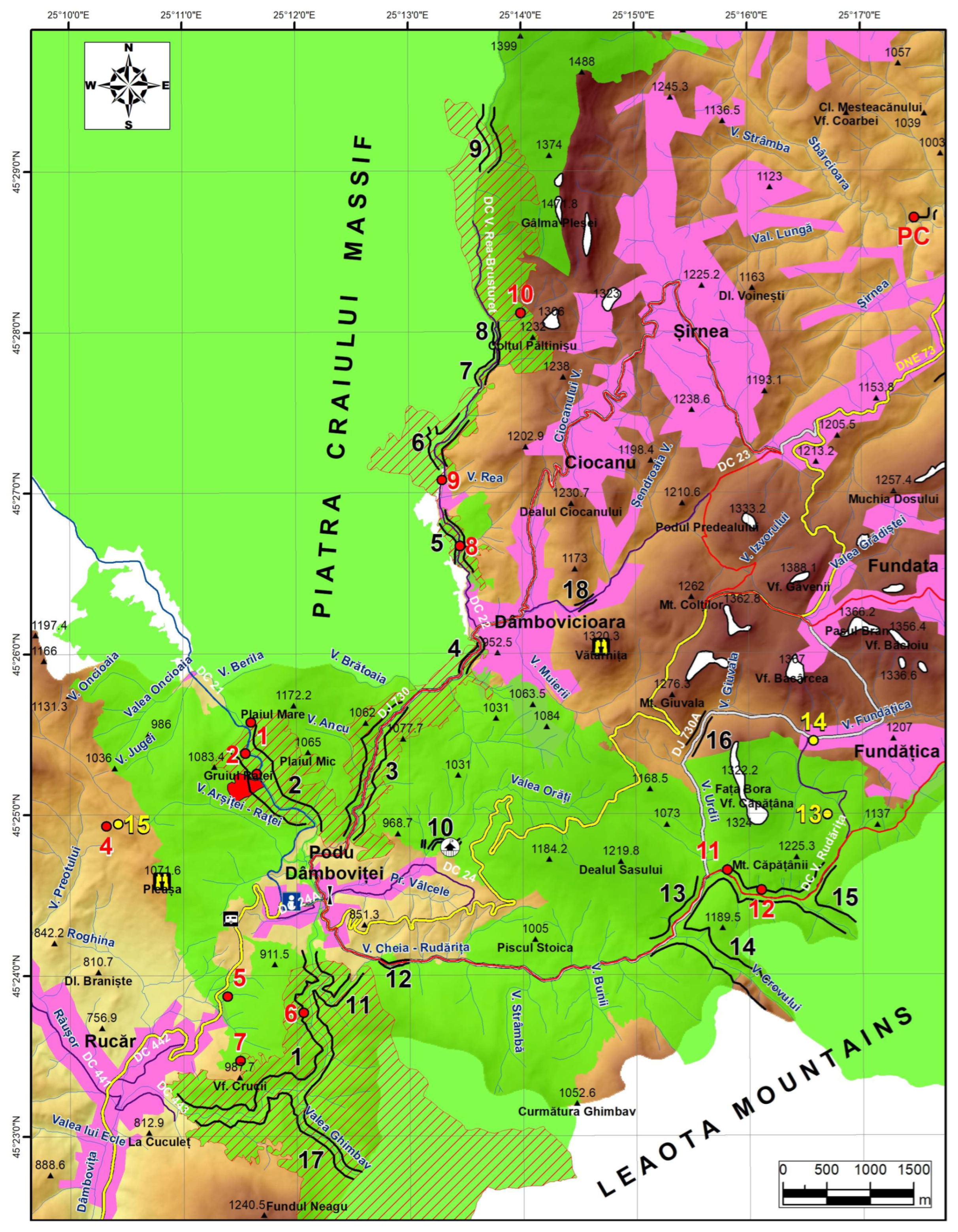
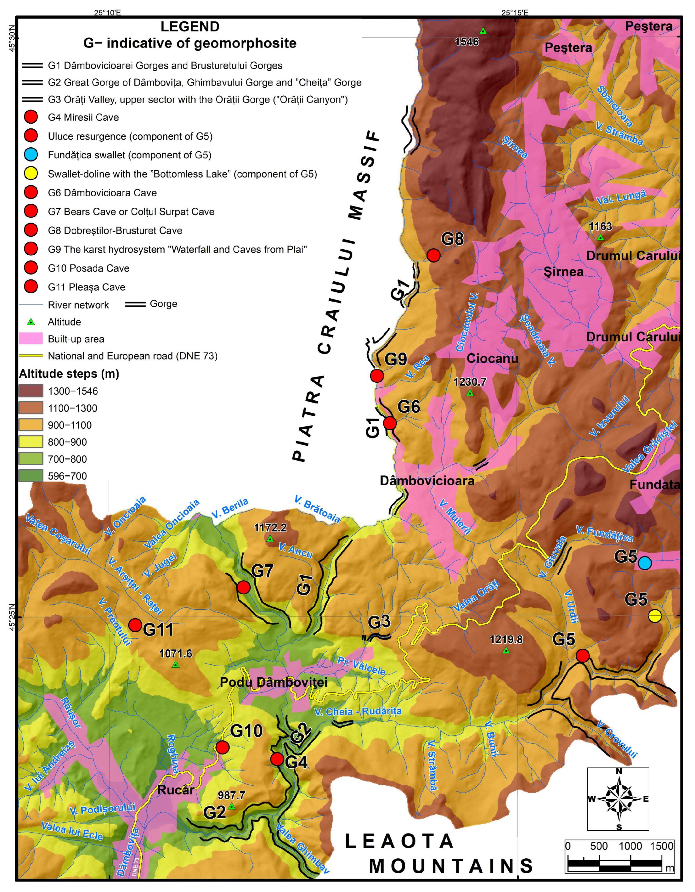
2. Study Area
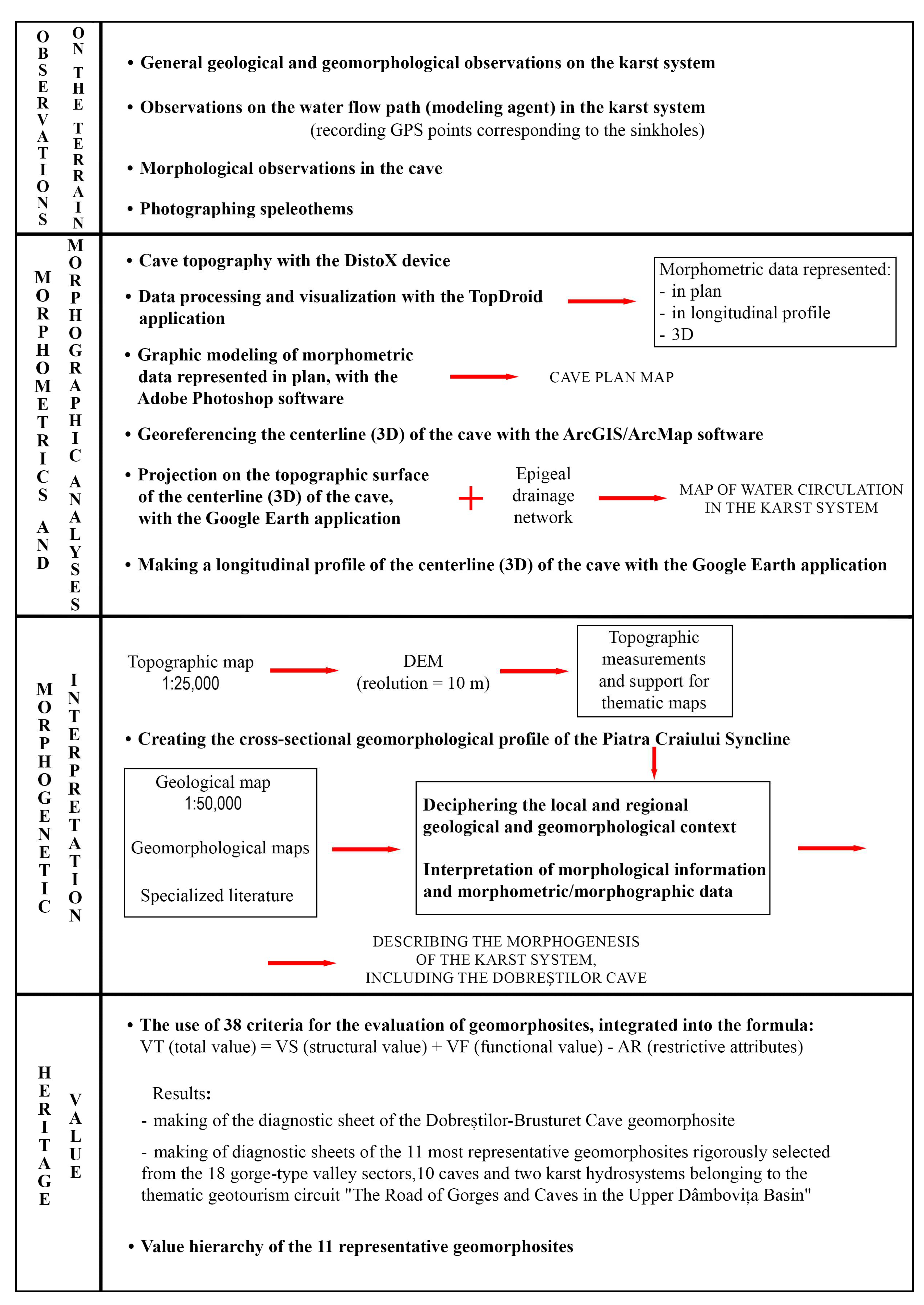
3. Materials and Methods
4. Results
4.1. Geological Features
4.2. Geomorphology
5. Discussion
5.1. Geomorphologic Features of the Dobreștilor–Brusturet Cave
5.2. The Heritage Value of the Dobreștilor–Brusturet Cave Within the Thematic Geotourism Circuit “The Road of Gorges and Caves in the Upper Dâmbovița Basin”
5.3. Ecological and Zoospeological Value of Dobreștilor–Brusturet Cave
6. Conclusions
Author Contributions
Funding
Data Availability Statement
Acknowledgments
Conflicts of Interest
References
- Joice, E.B. Geological Heritage of Australia: Selecting the Best for Geosites and World Heritage, and Telling the Story for Geotourism and Geoparks; Extended Abstract; AESC: Melbourne, Australia, 2006. [Google Scholar]
- Dowling, R.; Newsome, D. Geotourism; Elsevier: Oxford, UK, 2018. [Google Scholar]
- Cocean, G. Trascău Mountains. Relief, Geomorphosituri, Turism; Presa Universitară Clujeană Publishing House: Cluj-Napoca, Romania, 2011; 269p. [Google Scholar]
- Coratza, P.; Giusti, C. Methodological Proposal for the Assessment of the Scientific Quality of Geomorphosites. Alp. Mediterr. Quat. 2005, 18, 307–314. [Google Scholar]
- Panizza, M. The geomorphodiversity ofthe Dolomites (ltaly): A key of geoheritage assessment. Geoheritage 2009, 1, 33–42. [Google Scholar] [CrossRef]
- Reynard, E. The Assessment of Geomorphosites. In Geomorphosites; Reynard, E., Coratza, P., Regolini-Bissig, G., Eds.; Verlag Dr. Friedrich Pfeil: Munchen, Germany, 2009; pp. 63–71. [Google Scholar]
- Serrano, E.; Gonzalez Trueba, J.J. Assessment of Geomorphosites in Natural Protected Areas: The Picos de Europa National Park (Spain). Géomorphologie Relief Process. Environ. 2005, 11, 197–208. [Google Scholar] [CrossRef]
- Bruschi, V.M.; Cendrero, A. Geosite Evaluation: Can We Measure Intangible Values? Alp. Mediterr. Quat. 2005, 18, 293–306. [Google Scholar]
- Pereira, P.; Pereira, D.; Caetano Alves, M.I. Geomorphosites Assessment in Montesinho Natural Park (Portugal). Geogr. Helv. 2007, 62, 159–168. [Google Scholar] [CrossRef]
- Pralong, J.P. A Method for Assessing the Tourist Potential and Use of Geomorphological Sites. Geomorphol. Relief Process. Environ. 2005, 3, 189–196. [Google Scholar] [CrossRef]
- Ilieş, D.; Josan, N. Geomorfosituri și Geopeisaje; Editura Universității din Oradea: Oradea, Romania, 2009. [Google Scholar]
- Artugyan, L. Geomorphosites assessment in karst terrains: Anina karst region (Banat Mountains, Romania). Geoheritage 2017, 9, 153–162. [Google Scholar] [CrossRef]
- Cocean, G.; Surdeanu, V.I. The Assessment of Geomorphosites of Touristic Interest in the Trascău Mountains. Stud. Univ. Babeș-Bolyai Geogr. 2011, 56, 67–81. [Google Scholar]
- Cocean, G. The inventory and hierarchy of geomorphosites in the Vlădeasa Massif. Rom. Journ. Geogr. 2012, 56, 175–181. [Google Scholar]
- Cocean, G.; Cocean, P. An Assessment of Gorges for Purposes of Identifying Geomorphosites of Geotourism Value in the Apuseni Mountains (Romania). Geoheritage 2017, 9, 71–81. [Google Scholar] [CrossRef]
- Munteanu, G. Nature-based tourism in the karst gorges of the Southern Carpathians. Rom. Journ. Geogr. 2021, 65, 159–169. [Google Scholar]
- Comănescu, L.; Nedelea, A.; Dobre, R. Inventoring and evaluation of geomorphosites in the Bucegi Mountains. In Forum Geografic, Studii și Cercetări de Geografie și Protecția Mediului; Editura Universității din Craiova: Craiova, Romania, 2009; pp. 38–43. [Google Scholar]
- Comănescu, L.; Ielenicz, M.; Nedelea, A. Relieful și Valorificarea lui în Turism; Editura Ars Docendi: Bucharest, Romania, 2010. [Google Scholar]
- Comănescu, L.; Nedelea, A.; Dobre, R. The Evaluation of Geomorphosites from the Ponoare Protected Area, Forum geografic. Stud. Cercet. Geogr. Protecția Mediu. 2012, XI, 54–61. [Google Scholar] [CrossRef]
- Nae, A.; Vlaicu, M.; Popa, I.; Vasilica, I.; Constantinescu, T.; Nitzu, E. First Note on the Invertebrate Fauna of Caves from the Piatra Craiului National Park; Travaux l’Institut Spéologie “Emile Racovitza”: Bucharest, Romania, 2004; Volume 43, pp. 133–164. [Google Scholar]
- Popescu-Argeșel, I. Valea Dâmboviței; Sport-Turism Publishing House: Bucharest, Romania, 1986. [Google Scholar]
- Constantinescu, T.; Dobrescu, I. The Caves Catalogue of Piatra Craiului National Park Research in Piatra Craiului National Park; Editura Universității Transilvania: Brasov, Romania, 2006; Volume III, pp. 10–30. [Google Scholar]
- Constantinescu, T. Piatra Craiului Massif. Geomorphologic Study; Editura Universitară: Bucharest, Romania, 2009; 164p. [Google Scholar]
- Bârnoaia Pothole (Bârnoaiei Hole). Available online: https://www.speologie.org/avenul-barnoaia-gaura-barnoaiei (accessed on 25 October 2024).
- Bilașco, Ș.; Trif, S.; Petrea, D.; Cocean, P.; Fodorean, I.; Roșca, S.; Vescan, I. Contributions to the Morphogenesis, Inventory, and Valorization of a Unique Speleological Geomorphosite from Miresii Cave-The Large Key of Dâmbovița, the Corridor Bran-Dragoslave (Romania). Heritage 2024, 7, 5814–5838. [Google Scholar] [CrossRef]
- Lazăr, I.; Grădinaru, M.; Andrășanu, A.; Bucur, I.I.; Săsăran, E.; Stoica, M. Jurassic to Cretaceaous Evolution of the Estern Getic Domain—Rucăr—Bran Zone; Field Trip Guide Book; Editura Universității din București: Bucharest, Bucharest, 2017. [Google Scholar]
- Constantinescu, T. The Karst of Piatra Craiului (2). L’Exokarst; Travaux l’Institut Spéologie “Emile Racovitza”: Bucharest, Romania, 1997. [Google Scholar]
- Trif, S. Paleontological Sites (Marine Invertebrates) and Paleolithic Archaeosites in the Transcarpathian Corridor Bran—Rucar—Dragoslavele, Landmarks of a Geoturism with Didactic and Scientific Purpose. In Proceedings of the National Conference Tourist Resources, Leisure and Sports Tourism, Factors of Community Progress, Bistrița, Romania, 7–9 December 2019. [Google Scholar]
- Cârciumaru, M.; Nițu, E.-C.; Dobrescu, R.; Ștefănescu, R. Paleolithic in Brasov County; Valahia University Press: Targoviste, Romania, 2010. [Google Scholar]
- GEO No. 57 of June 20, 2007 on the Regime of Protected Natural Areas, Conservation of Natural Habitats, Wild Flora and Fauna. Available online: http://legislatie.just.ro/Public/DetaliiDocument/83289 (accessed on 10 April 2022).
- Law No. 49 of April 7, 2011 for the Approval of the Government Emergency Ordinance No. 57/2007 on the Regime of Protected Natural Areas, Conservation of Natural Habitats, Wild Flora and Fauna. Available online: https://legislatie.just.ro/Public/DetaliiDocumentAfis/127715 (accessed on 10 April 2022).
- Summermatter, N. Quelques Reflexions Sur Les Techniques Scripto-Illustratives Utilizeseseseses Dans Les Brouchures Relatives Aux Itineraires Didactiques. In Geomorphologie et Tourisme; Reynard, E., Holzmann, C., Guex, D., Summermatter, N., Eds.; Travaux et recherches n. Solon Editorial House: Bistrita, Romania, 2003. [Google Scholar]
- Dobrescu, I.; Everac, P. Resurse și Ispite în Țara Muscelului; Semne Publishing House: Bucharest, Romania, 2003; 182p. [Google Scholar]
- Badea, L.; Niculescu, G.; Roată, S.; Buza, M.; Sandu, M. Unitățile de relief ale României, Carpații Meridionali și Munții Banatului; Ars Docendi Publishing House: Bucharest, Romania, 2001. [Google Scholar]
- Law No. 4/1972 on the Management of Forests under the Direct Administration of Municipalities. Available online: https://lege5.ro/gratuit/gyydsobv/legea-nr-4-1972-privind-gospodarirea-padurilor-aflate-in-administrarea-directa-a-comunelor (accessed on 5 April 2022).
- Law No. 5/2000 on the Approval of the National Spatial Plan-Section III-Protected Areas. Available online: https://lege5.ro/Gratuit/gi3donbu/legea-nr-5-2000-privind-aprobarea-planului-de-amenajare-a-teritoriului-national-sectiuneaa-iii-a-zone-protejate (accessed on 5 April 2022).
- Order No. 1964 of December 13, 2007 on the Establishment of the Protected Natural Area Regime of Sites of Community Importance as Part of the Natura 2000 European Ecological Network in Romania. Available online: https://legislatie.just.ro/Public/DetaliiDocument/89382 (accessed on 5 April 2022).
- Pop, O.G.; Murariu, D.; Ionescu, D.T.; Indreica, A.V.; Gurean, D.M.; Vezeanu, C.; Minodora, M.; Bordea, I. Piatra Craiului National Park-Ghidul Specieilor și Habitatelor de Interesse Comunitar și National; Editura Ars Docendi; University of Bucharest: Bucharest, Romania, 2015; 288p. [Google Scholar]
- Management Plan from February 21, 2020, of the National Park and the Natura 2000 Site ROSCI0194 Piatra Craiului. Available online: http://legislatie.just.ro/Public/DetaliiDocument/225024 (accessed on 14 April 2022).
- Natura 2000 site, code ROSCI 0194 Piatra Craiului, European Environment Agency. Available online: https://eunis.eea.europa.eu/sites/ROSCI0194 (accessed on 9 September 2023).
- Ministry of National Defense, Military Topographic Directorate, Bucharest, Topographic Maps 1:25000 (1974–1986), Accessed from the Secret Documents Office of the Faculty of Geography of “Babes-Bolyai” Cluj-Napoca University. Available online: https://www.annalsreview.geo.unibuc.ro/ (accessed on 3 February 2024).
- Hutchinson, M.F.; Xu, T.; Stein, J.A. Recent Progress in the ANUDEM Elevation Gridding Procedure. In Geomorphometry 2011; Hengel, T., Evans, I.S., Wilson, J.P., Gould, M., Eds.; Esri Press: Redlands, CA, USA, 2011; pp. 19–22. [Google Scholar]
- Patrulius, D.; Dimitrescu, R.; Gherasi, N.; Manilici, V.; Popescu, I. Geological Map of R. S. Romania, Scale: 1:50,000, Map Sheet 110 c Rucar L-35-87-C.; Romanian National Institute of Geology: Bucharest, Romania, 1971. [Google Scholar]
- Cohen, K.M.; Finney, S.C.; Gibbard, P.L.; Fan, J.-X. The ICS International Chronostratigraphic Chart. Epis. J. Int. Geosci. 2013, 36, 199–204. Available online: https://stratigraphy.org/chart (accessed on 14 August 2023). [CrossRef] [PubMed]
- Patrulius, D.; Antonescu, E.; Avram, E.; Baltres, A.; Dumitrică, P.; Iordan, M.; Iva, M.; Morariu, A.; Pop, G.; Popa, E.; et al. The Complex Petrologic and Biostratigraphic Study of the Jurassic and Neocomian Formations from the Romanian Carpathians and Dobrogea in View to Evaluate the Ore-Deposit Potential. The Leaota-Brașov-Perșani Mountains Area; Unpublished Scientific Report; Institute of Geology and Geophysics: Bucharest, Romania, 1980; 142p. [Google Scholar]
- Patrulius, D. Upper Jurassic—Lower Cretaceous carbonate rocks in the eastern part of the Getic carbonate platform and the adjacent flysch troughs. In Carbonate Rocks and Evaporates—Guidebook; Patrulius, D., Drăgănescu, A., Baltres, A., Popescu, B., Rădan, S., Eds.; Guidebook Series 15; Institute of Geology and Geophysics: Bucharest, Romania, 1976; pp. 71–82. [Google Scholar]
- Patrulius, D.; Avram, E. Stratigraphie et correlation des terrains néocomiens et barrémo-bédouliens du Couloir de Dâmbovicioara (Carpathes Orientales). Meet. Rep. 1976, 62, 135–160. [Google Scholar]
- Patrulius, D. Geology of the Bucegi Massif and the Dâmbovicioara Corridor; Editura Academiei R.S.R.: Bucharest, Romania, 1969; 321p. [Google Scholar]
- World Imagery. Satellite Imagery from Dates 02/23/2016, Google Earth Pro. Available online: https://www.google.com/intl/ro/earth/versions/#earth-pro (accessed on 23 April 2024).
- Mutihac, V.; Stratulat, M.I.; Fechet, R.M. Geologia României; Editura Didactică și Pedagogică, R.A.: Bucharest, Romania, 2004. [Google Scholar]
- Țicleanu, N.; Pauliuc, S. General Geology; Editura Universitară: Bucharest, Romania, 2003. [Google Scholar]
- Giurgiu, I.V.; Vlădulescu, M. Uluce Cave, Rucar–Bran Corridor, Map, Description, România-Natura. Available online: https://sites.google.com/site/romanianatura17/home/carpatii-meridionali/culoarul-rucar---bran/pestera-uluce (accessed on 10 September 2023).
- Giurgiu, I.V. Posada Cave, Under the Rucar–Brasov Highway, Romania-Natura. Available online: https://sites.google.com/site/romanianatura49/home/carpatii-meridionali/culoarul-rucar-bran-intre-bucegi-si-piatra-craiului/pestera-posada-sub-soseaua-rucar---brasov (accessed on 10 September 2023).
- Bleahu, M.; Decu, V.; Negrea, Ș.; Pleșa, C.; Povară, I.; Viehmann, I. Caves in Romania; Editura Științifică și Enciclopedică: Bucharest, Romania, 1976; 415p. [Google Scholar]
- Cocean, P. Munții Apuseni. Processes and Karst Forms; Editura Academiei Române: Bucharest, Romania, 2000. [Google Scholar]
- Mac, I. Geomorphosphere and Geomorphosystems; Presa Universitară Clujeană Publishing House: Cluj-Napoca, Romania, 1996. [Google Scholar]
- Bleahu, M. Morfologia Carstica; Editura Științifică: Bucharest, Romania, 1974; 590p. [Google Scholar]
- Nitzu, E. The Cholevinae of Romania (exclusive of Leptodirini) (Coleoptera, Leiodidae) with special reference to the hypogeal records. Zootaxa 2013, 3620, 351–378. [Google Scholar] [CrossRef] [PubMed]
- Coleoptera Europaea, Leiodidae Catops fuscus (Panzer, 1794a). Available online: https://coleonet.de/coleo/texte/catops.htm#fuscus (accessed on 23 September 2024).

| Crt. No. | Geomorphosite (G—Indicative) | Structural Value | Functional Value | Restrictive attribute | Total | ||||
|---|---|---|---|---|---|---|---|---|---|
| VS1 | VS2 | VS3 | VF1 | VF2 | VF3 | ||||
| 1 | G1 Dâmbovicioarei Gorges and Brusturetului Gorges | 5.00 | 3.25 | 3.00 | 2.75 | 5.00 | 8.25 | 0.75 | 26.50 |
| 2 | G2 Great Gorge of Dâmbovița, Ghimbavului Gorge, and “Cheița” Gorge | 5.00 | 3.25 | 3.00 | 1.25 | 4.75 | 5.75 | 0.50 | 22.50 |
| 3 | G3 Orăți Valley, upper sector with Orății Gorge (“Orății Canyon”) | 4.25 | 2.50 | 2.00 | 2.50 | 4.00 | 5.75 | 1.25 | 19.75 |
| 4 | G4 Miresii Cave | 5.25 | 2.50 | 2.25 | 1.25 | 4.00 | 4.50 | 0.25 | 19.50 |
| 5 | G5 The karst hydro system “Fundățica swallet and Rudărița Valley–Uluce resurgence” | 5.50 | 1.75 | 2.00 | 1.25 | 3.50 | 5.50 | 1.50 | 18.00 |
| 6 | G6 Dâmbovicioara Cave | 3.00 | 1.50 | 1.75 | 1.75 | 3.25 | 7.25 | 1.25 | 17.25 |
| 7 | G7 Bears Cave or Colțul Surpat Cave | 3.75 | 1.75 | 2.00 | 2.00 | 3.50 | 5.25 | 1.25 | 17.00 |
| 8 | G8 Dobreștilor–Brusturet Cave | 4.75 | 2.00 | 2.00 | 0.75 | 3.25 | 3.75 | 1.00 | 15.50 |
| 9 | G9 The karst hydro system “Waterfall and Caves from Plai” | 3.50 | 1.75 | 1.50 | 0.25 | 3.25 | 5.50 | 1.25 | 14.50 |
| 10 | G10 Posada Cave | 4.00 | 1.50 | 1.50 | 1.25 | 2.50 | 5.00 | 1.50 | 14.25 |
| 11 | G11 Pleașa Cave | 4.00 | 1.50 | 0.25 | 0.25 | 1.50 | 4.50 | 0.75 | 11.25 |
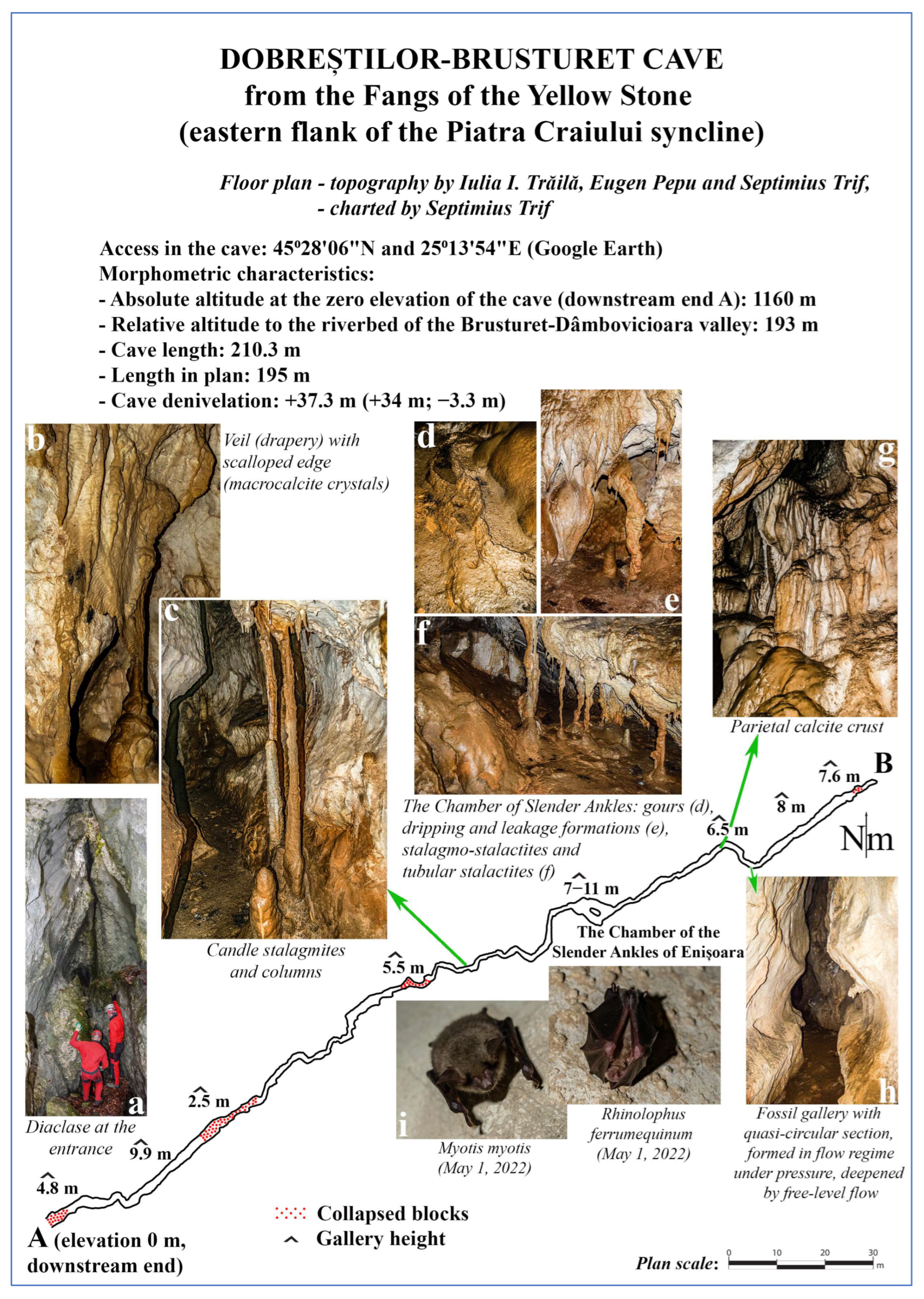
| Name | DOBREȘTILOR–BRUSTURET CAVE | |
|---|---|---|
| Call sign | G8 | |
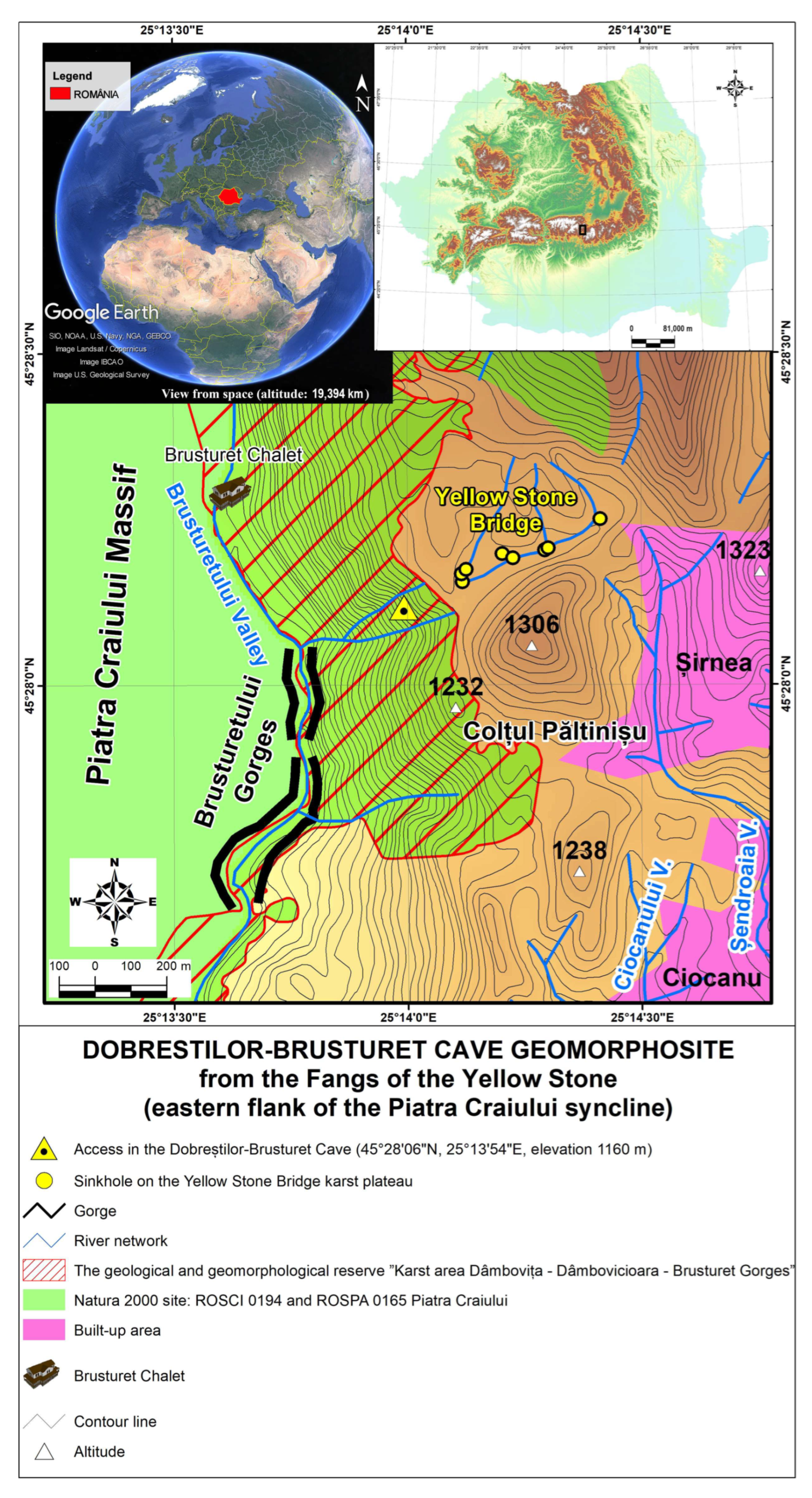
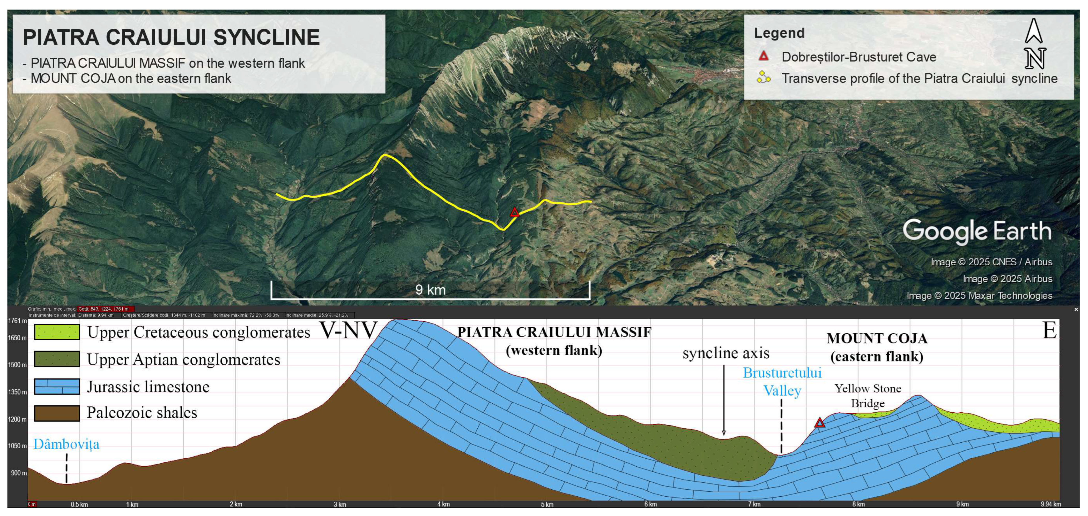
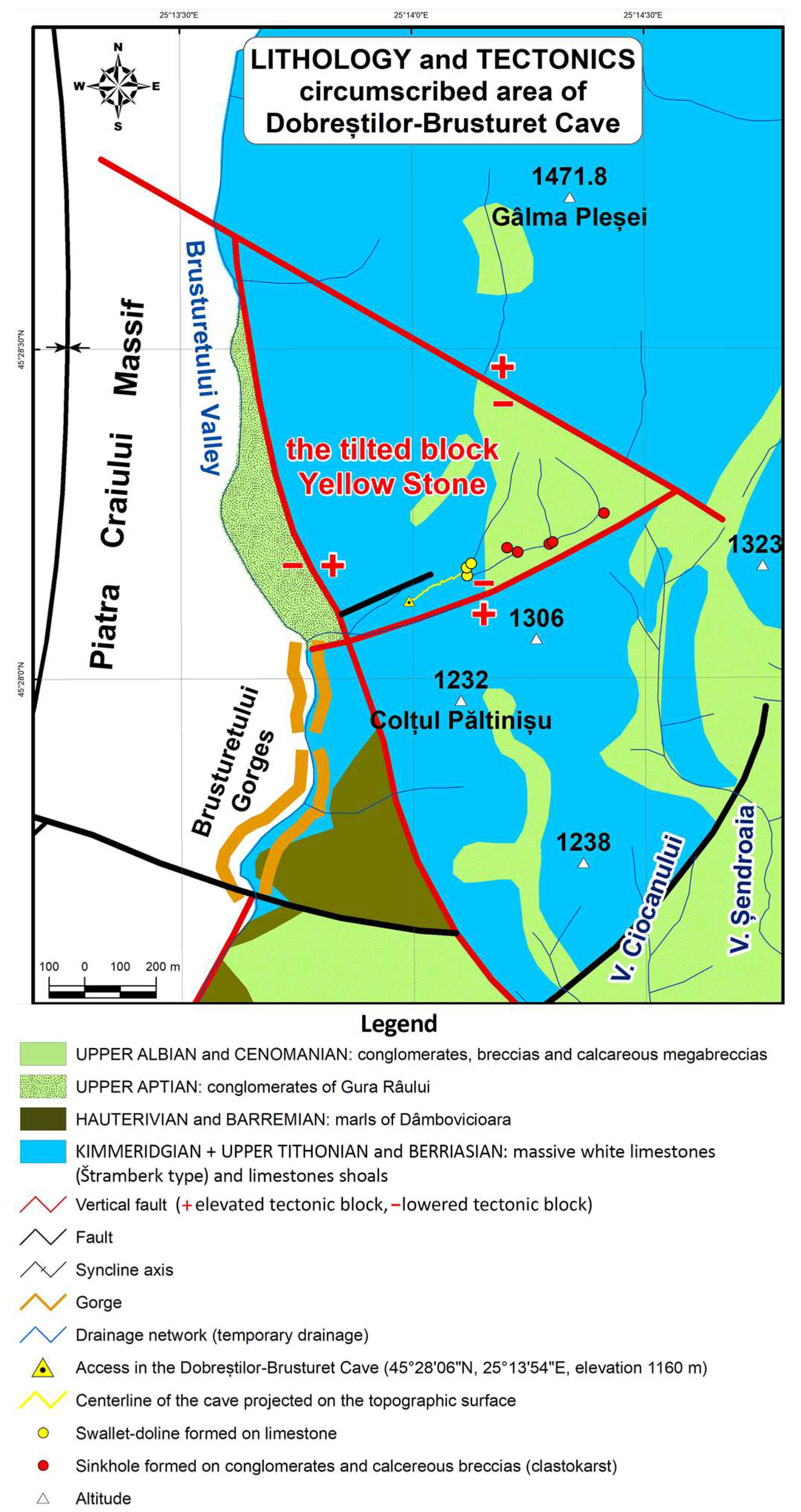
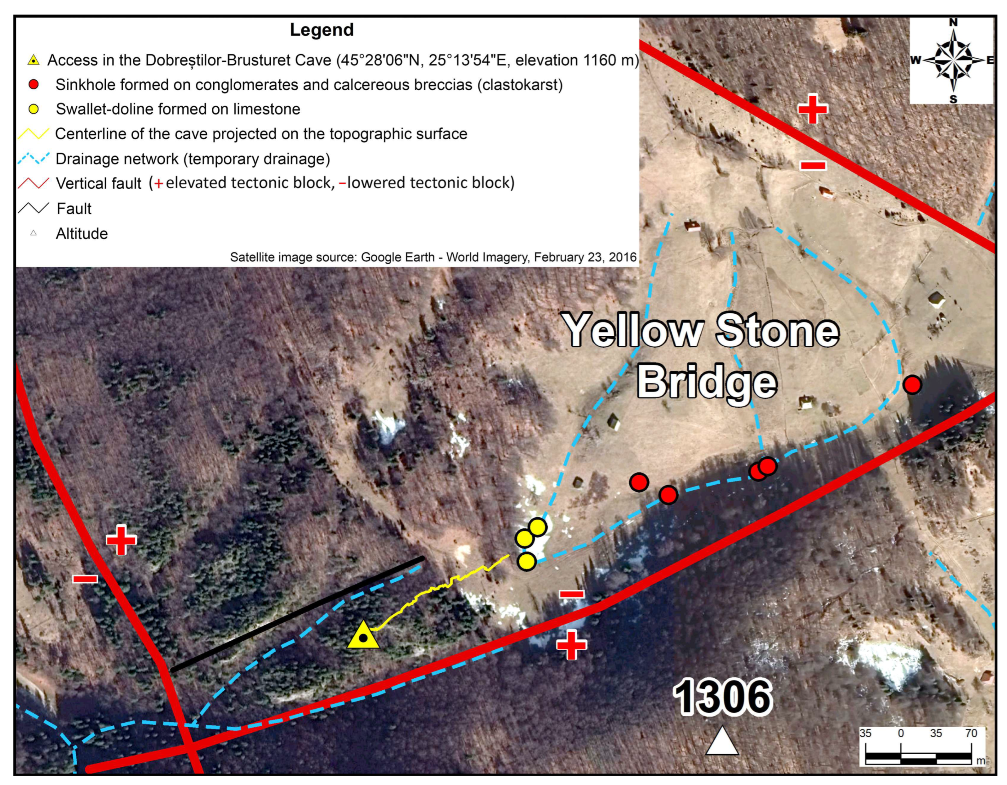
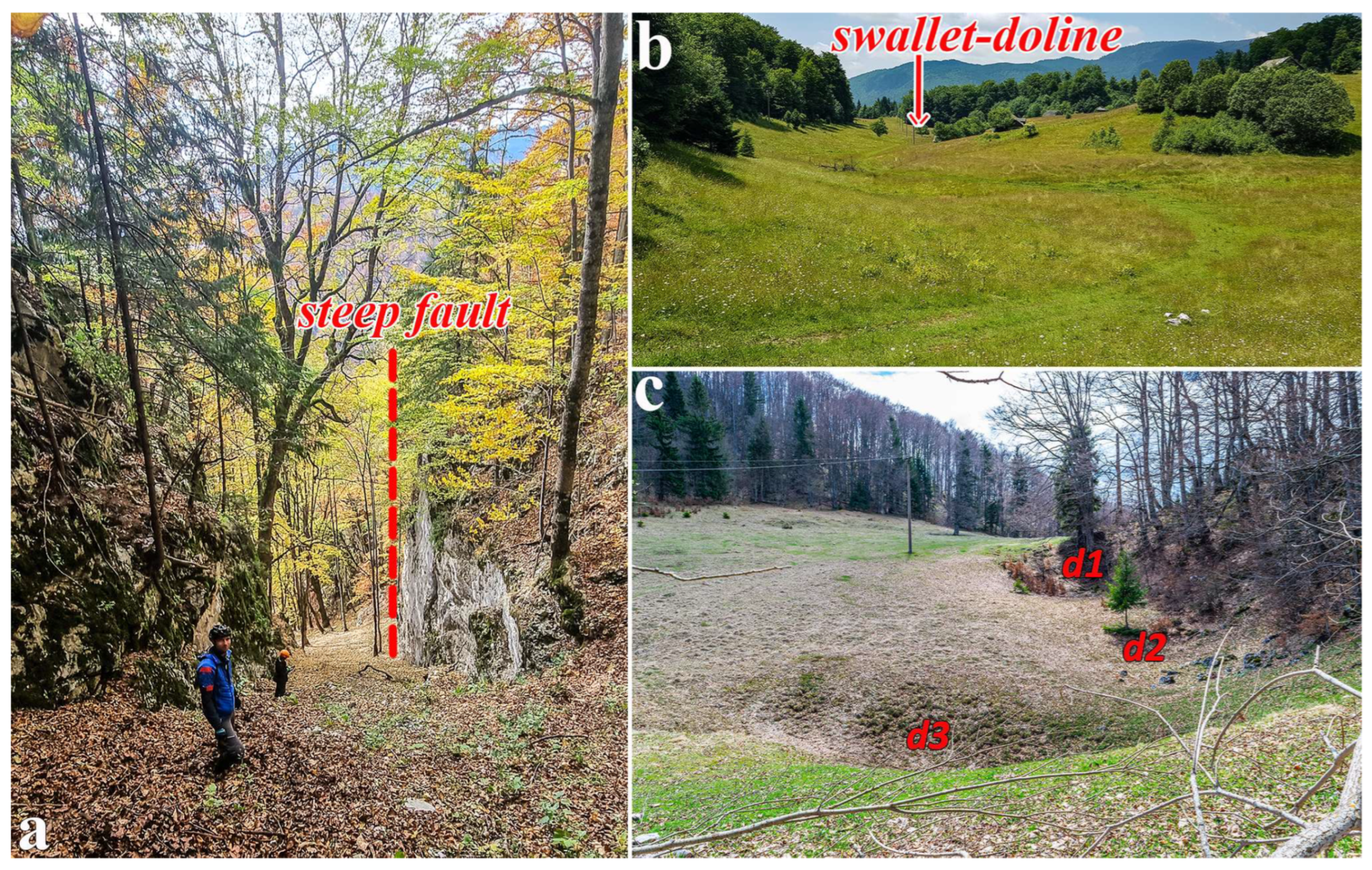
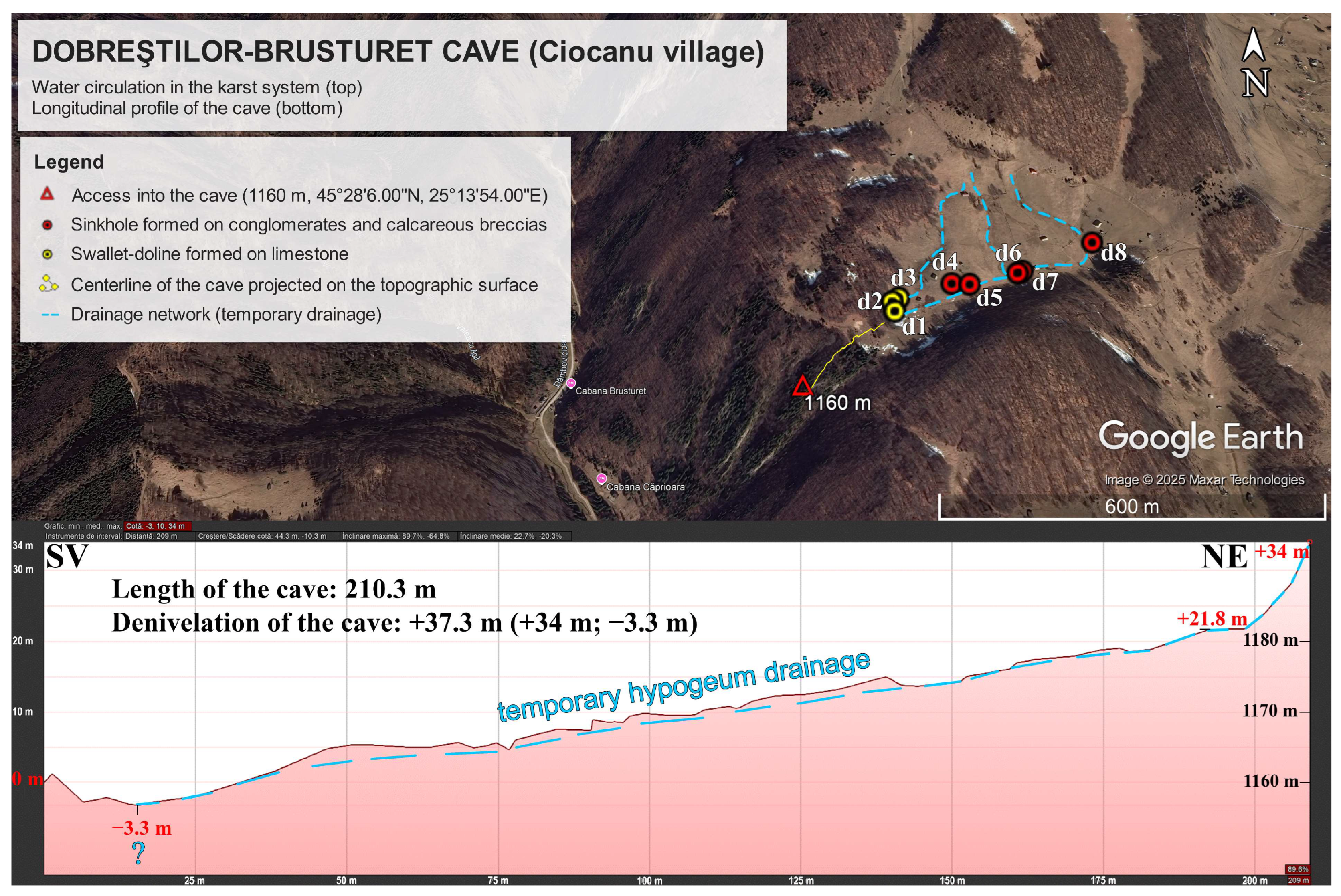
| Geographical location access (elevation 0 m) | In the calcareous marker Colții Pietrei Galbene on the left slope of the upper Brusturetului Gorge (Cheia Strâmtă), at the absolute altitude of 1160 m | |
| Administrative territorial unit | Ciocanu village (Dâmbovicioara commune) | |
| Types | Speleological geomorphosite | |
| Extension | Linear | |
| Total value | 15.50 p | |
| Structural value | 8.75 p | |
| Functional value | 7.75 p | |
| Restrictive attribute | 1.00 p | |
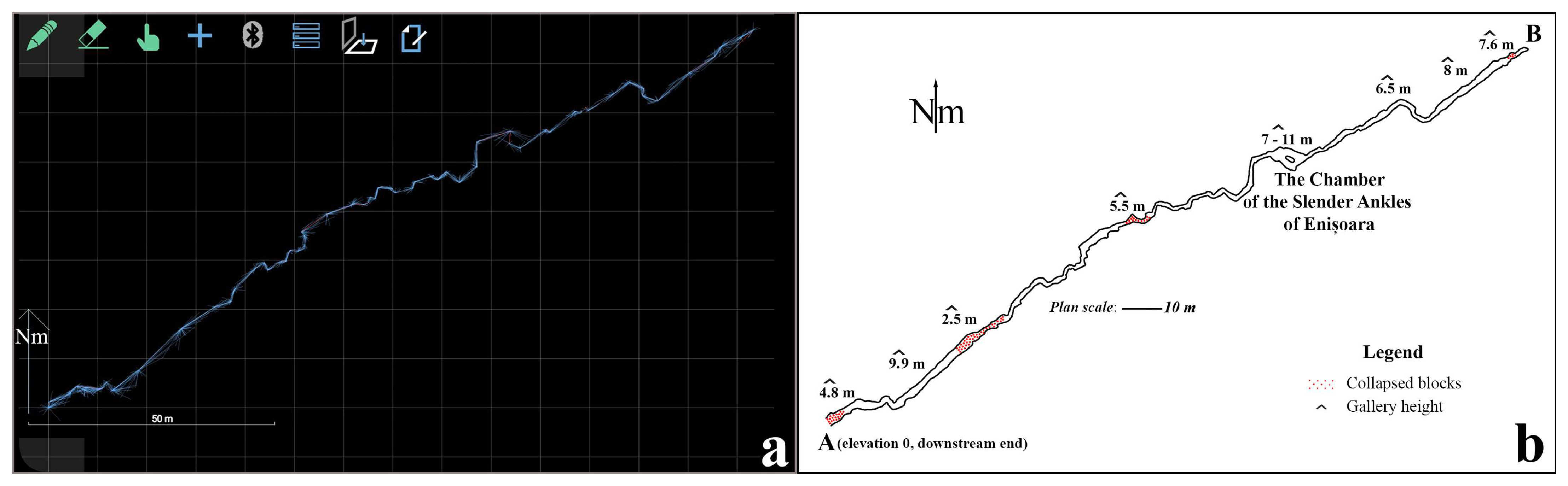
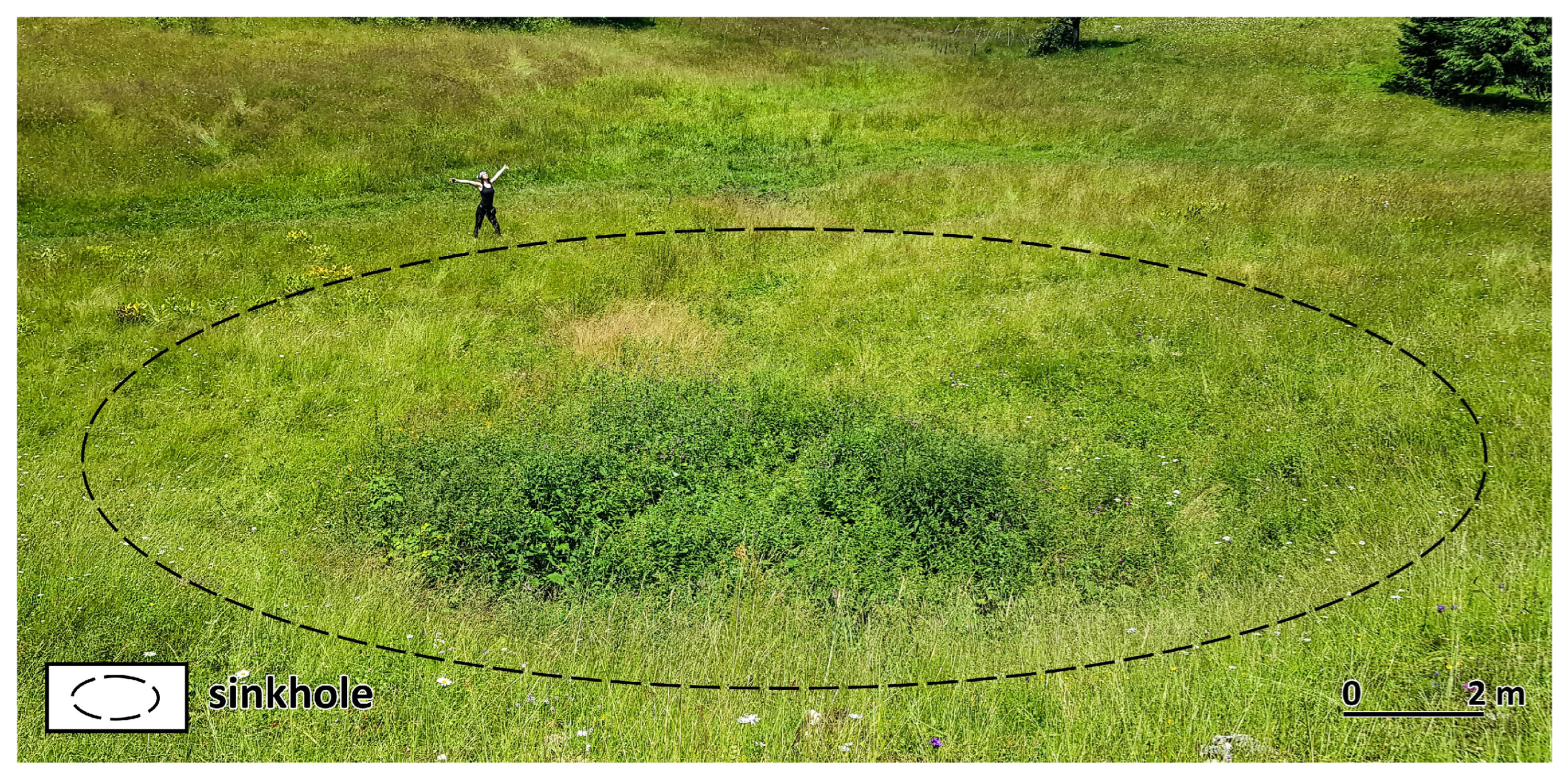
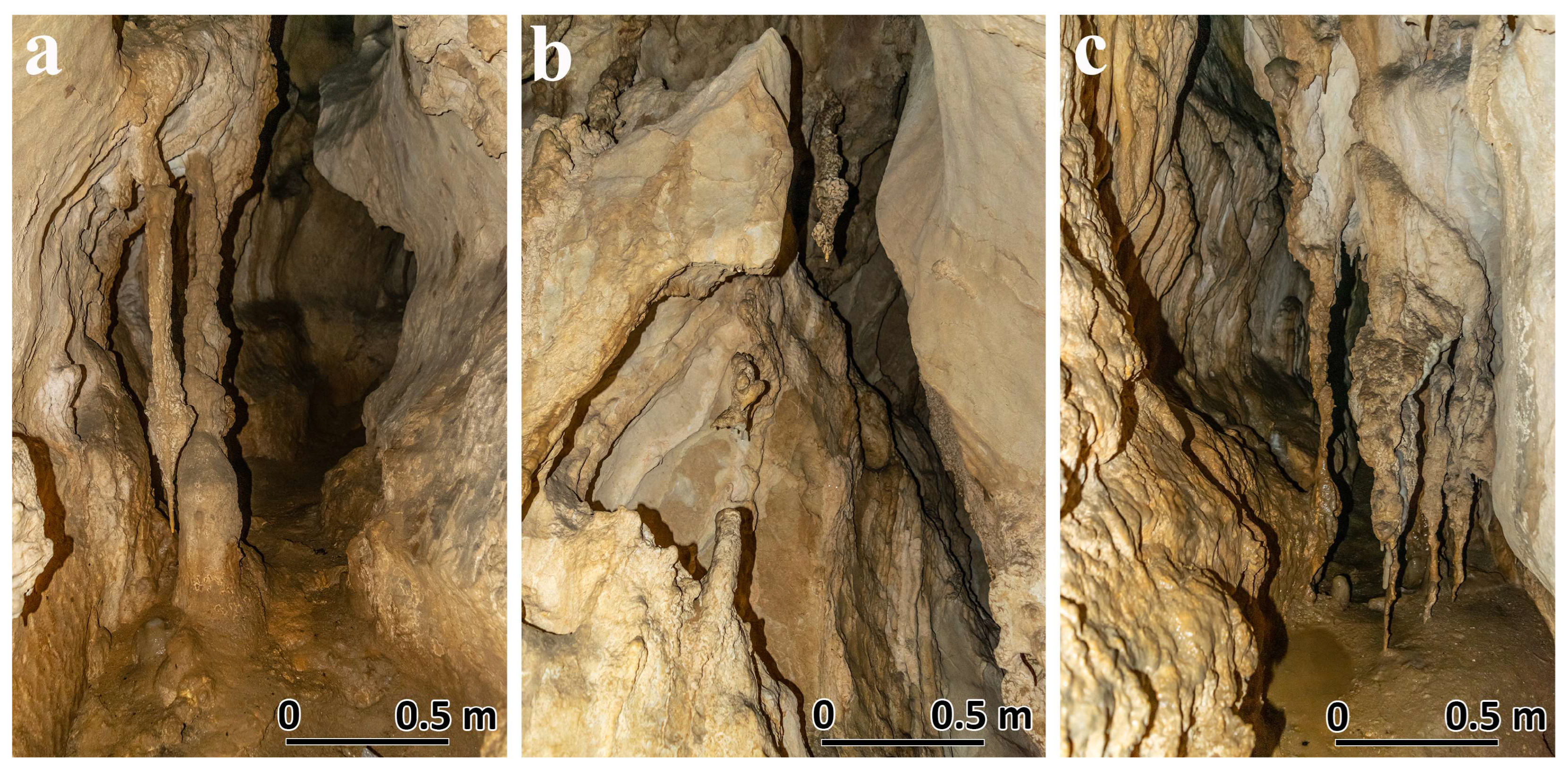
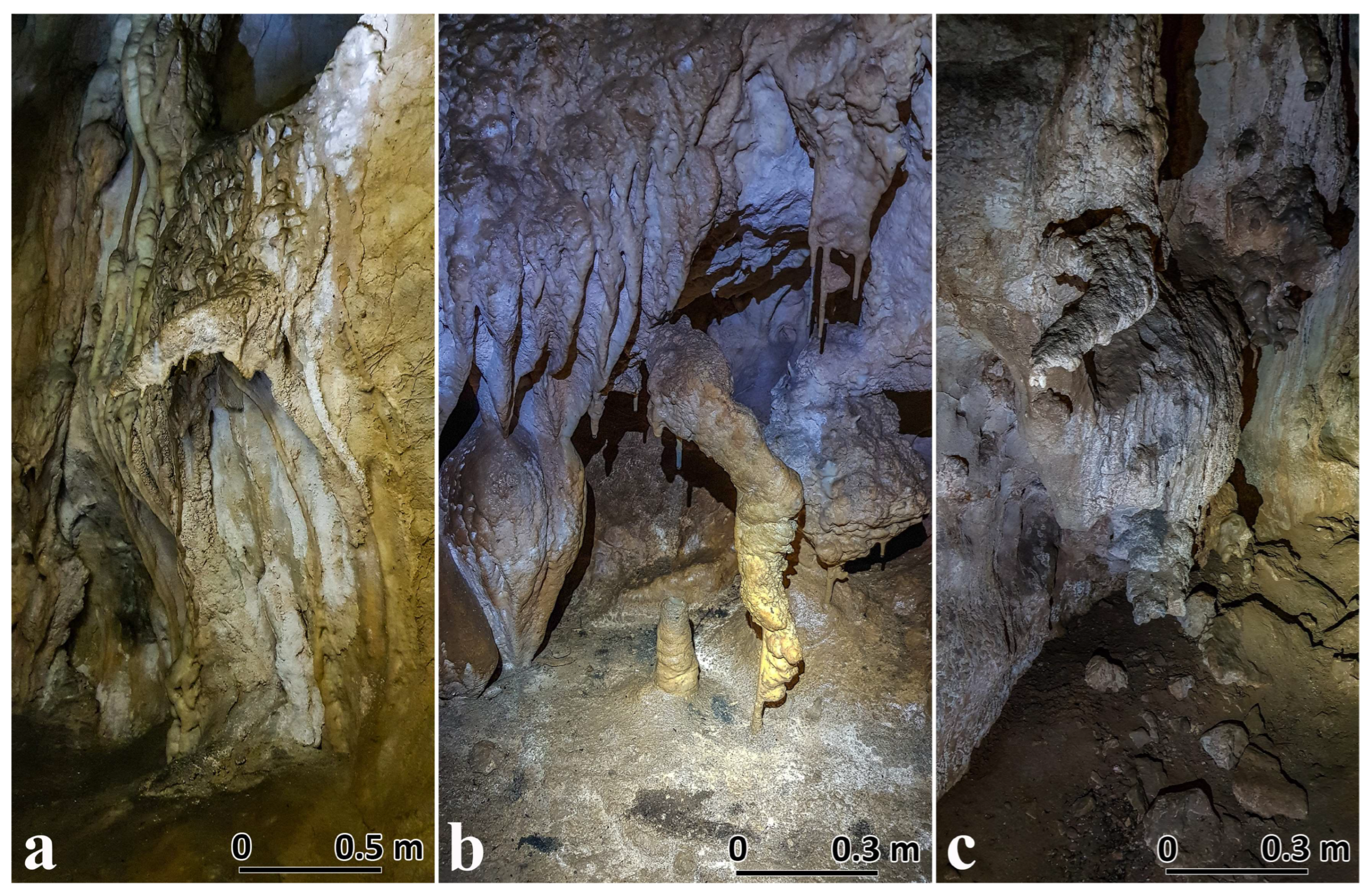
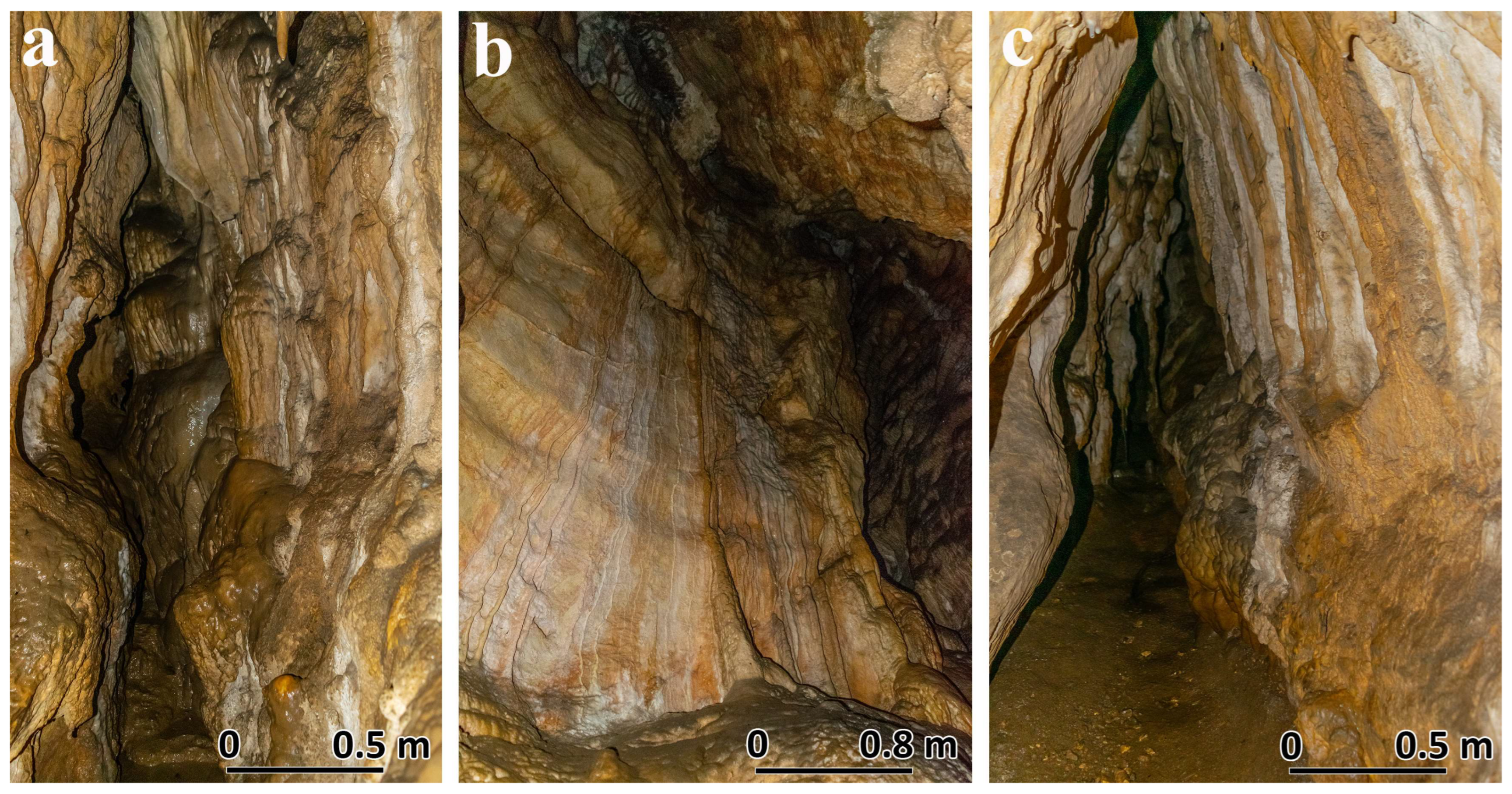
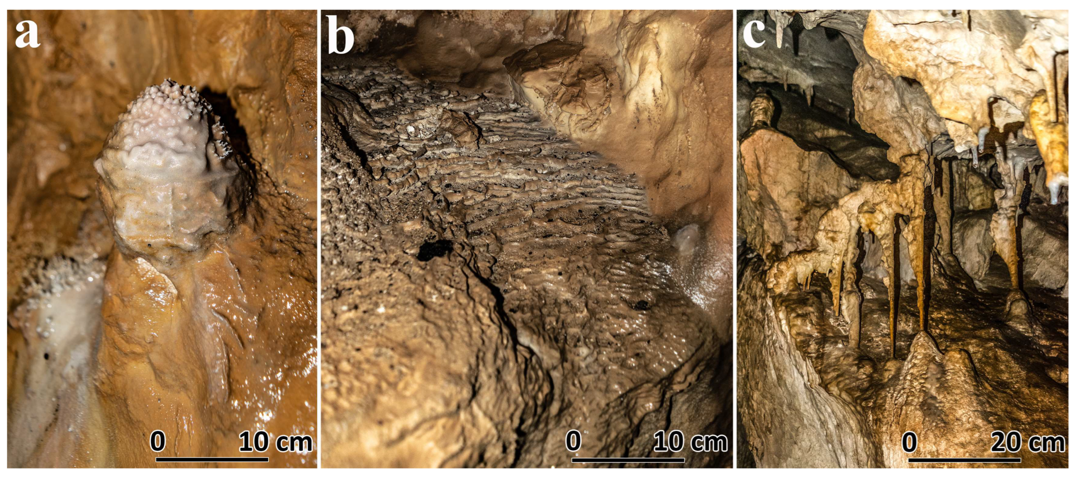
| Geomorphologic Value (VS1) | 4.75 p | - Genesis (SV 1a): complex speogenesis, involving four morphogenetic factors: tectono-gravitational processes (tectonic tensile diaclase, deposits, and incision forms), chemical corrosion (in some sections), torrential erosion, and chemical precipitation (gravitational dripping and prelingering forms) (1.00 p). - Dynamics (VS 1b): landforms with slow, inferred dynamics (0.50 p). - Complexity (VS 1c): Five elements of geomorphological interest—fossiliferous gallery sections with a quasi-circular cross-section (pressure flow), diversified drip forms (including anemolites), gravity seepage forms, calcitic eccentrites, stalagmitic basement floors (gours), and microgours on gently sloping surfaces of limestone sidewalls (1.00 p). - Integrity or conservation status (VS 1d): geomorphosite slightly affected (0.75 p). - Rarity (VS 1e): regionally unique speleological geomorphosite (Bucegi Mountains–Leaota) due to the diversity and richness of the drip forms (including anemolites), gravitational prelingering and microforms resulting from capillary prelingering (calcitic eccentrites) (0.50 p). - Geological structure (VS 1f): the cave was formed along a tectonic diaclase (developed quasi-parallel to the vertical fault to the south), open in massive carbonate deposits (with fine stratification), monoclinically arranged within the tilted block of Piatra Galbenă (0.75 p). - Cave development (VS 1g): total cave length is 210.3 m (0.25 p). |
| Aesthetic Value (AV2) | 2.00 p | - Physiognomy or physiognomy (VS 2a): geomorphosite with a unique physiognomy due to the diversity and richness of speleothems (0.75 p). - Chromaticity (VS 2b): chromatic gradation characteristic of karst voids (0.25 p). - Maximum exposure (VS 2c): selectively received speleological geomorphosite from observation points on the trail (0.50 p). - Landscape Attractiveness (VS 2d): the geomorphosite (with the embedded portal of the Yellow Stone Hills on the left slope of the Narrow Brusturet Gorge) is a component with local landscape attractiveness, but is also protected due to its landscape content. It belongs to RNGG1 (IUCN category IV) and is a nature monument (IUCN category III) included in the SPA (IUCN category Ib) of the PNPC (0.50 p). |
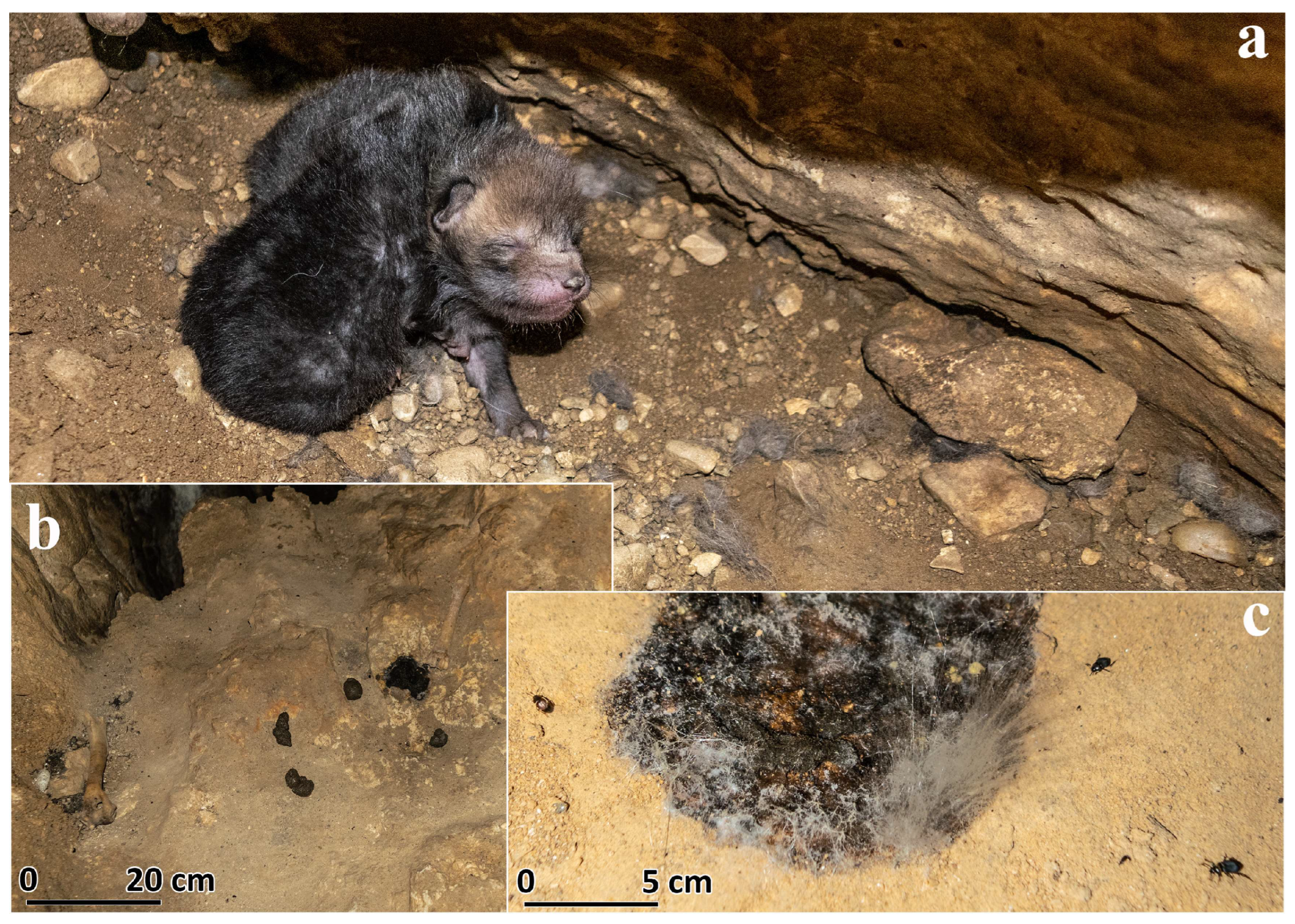
| Ecological Value (EV3) | 2.00 p | - Vegetation (SV 3a): bare biotope. - Fauna (VS 3b): 28 invertebrate species were inventoried, including the coleoptera Duvalius duebelianus (local endemic, rare troglobiont/edaphobiont) and Dermestes latissima (endemic to the Southern Carpathians). Chiroptera Myotis myotis and Rhinolophus ferrumequinum were identified (1.00 p). - Degree of protection as part of a protected natural area (SV 3c): fully protected geomorphosite, declared as a natural monument (IUCN category III) (1.00 p). |
| FUNCTIONAL VALUE (VF) = VF1 + VF2 + VF3 | ||
| TYPE | SCORE | JUSTIFICATION |
| Cultural (VF1) | 0.75 p | - Symbolism (VF 1a): the name “Dobreștilor” attributed to the cave is due to its discoverer, Ioan Dobrescu, who named it after his family name [1], an aspect with symbolic significance, in discrete association with geomorphosite (0.50 p). - Artistic and as graphic, cartographic, and photographic representations (VF 1b): the cave has less than 10 graphic representations (sketch—longitudinal profile, map) and photographs in tourist information/popularization works and one scientific paper (0.25 p). |
| Scientific (VF2) | 3.25 p | - Scientific references in publications (VF 2a): scientific references in occasional publications, scientific articles in national and one international journal (1.00 p). - Formative scientific resource/economic resource (tourism, etc.) (VF 2b): scientific resource with medium addressability, due to the interest in caving: physical caving and zoospeology—invertebrates (28 species) and chiroptera (0.50 p). - Function as a didactic model of morphogenetic and evolutionary landforms and/or geomorphologic processes (VF 2c): model with illustrative value (0.75 p). - Scientific representativity (relevance) (VF 2d): speleological geomorphosite with regional representativity (0.50 p). - Paleogeographic interest (VF 2e): geomorphosite of moderate paleogeographic interest, useful for deciphering the genesis and evolution of the cave in local and regional contexts (0.50 p). |
| Economic (VF3) | 3.75 p | - Number of possible activities (VF 3a): activities related to scientific research (mainly zoospeological), and geotourism may be practiced only on the basis of a permit issued by the PNPC administration (0.50 p). - Tourism potential (VF 3b): geomorphosite that does not arouse interest in tourism as the cavity is fully protected and is intended for scientific research (0 p). - Accessibility (VF 3c): car access up to 500 m from the geomorphosite, from DC 22 (0.75 p). - Related tourist infrastructure (VF 3d): Brusturet chalet (village Dâmbovicioara) about 1 km away (0.75 p). - Facilities and services (VF 3e): shared accommodation and catering services at the Brusturet Hut (0.25 p). - Distance to nearby localities with complex services (VF 3f): the distance to Rucăr and Zărnești is between 10 and 15 km (0.50 p). - Urban centers in the neighboring region (VF 3g): the nearest urban centers are the cities of Câmpulung (27,574 inhabitants/2021), 35 km away; and Zărnești (21,624 inhabitants/2021), 36 km away (0.50 p). - Tourism exploitation during the year (VF 3h): simple, occasional exploitation (0 p). - Tourism promotion of geomorphosite (VF 3i): brief, incomplete, unprofessional tourism promotion (under the name “Cave of the Foxes”) on a single website page, very rarely accessed. The targeting of the promotion reaches a regional level, at most (0.50 p). |
| RESTRICTIVE ATTRIBUTE (AR) = AR1 + AR2 + AR3 | ||
| SCORE | JUSTIFICATION | |
| 1.00 p | - Vulnerability to natural phenomena and processes (AR1): this speleological geomorphosite may be affected due to its vulnerability to seismic movements and other processes that may generate landslides (incachogenic deposits), but not affected as a whole (0.25 p). - Presence of economic activities with negative impacts or that could affect tourism and/or the geomorphosite (AR2): irrational pastoral activities in the area of drainage and water infiltration on the surface of the Piatra Galbenă karst plateau could affect the habitat of the speleological geomorphosite (0.50 p). - Unsightly elements (AR3): the iron fittings of a former metal grating that closed the upstream access about 90 m from the entrance (0.25 p) are visible. | |
Disclaimer/Publisher’s Note: The statements, opinions and data contained in all publications are solely those of the individual author(s) and contributor(s) and not of MDPI and/or the editor(s). MDPI and/or the editor(s) disclaim responsibility for any injury to people or property resulting from any ideas, methods, instructions or products referred to in the content. |
© 2025 by the authors. Licensee MDPI, Basel, Switzerland. This article is an open access article distributed under the terms and conditions of the Creative Commons Attribution (CC BY) license (https://creativecommons.org/licenses/by/4.0/).
Share and Cite
Trif, S.; Bilașco, Ș.; Sanda, R.; Ioan, F.; Vescan, I.; Barta, A.-I.; Irina, R. Geomorphological Analysis and Heritage Value of Dobreștilor–Brusturet Cave: A Significant Geomorphosite in the Bran–Dragoslavele Corridor, Romania. Heritage 2025, 8, 183. https://doi.org/10.3390/heritage8050183
Trif S, Bilașco Ș, Sanda R, Ioan F, Vescan I, Barta A-I, Irina R. Geomorphological Analysis and Heritage Value of Dobreștilor–Brusturet Cave: A Significant Geomorphosite in the Bran–Dragoslavele Corridor, Romania. Heritage. 2025; 8(5):183. https://doi.org/10.3390/heritage8050183
Chicago/Turabian StyleTrif, Septimius, Ștefan Bilașco, Roșca Sanda, Fodorean Ioan, Iuliu Vescan, András-István Barta, and Raboșapca Irina. 2025. "Geomorphological Analysis and Heritage Value of Dobreștilor–Brusturet Cave: A Significant Geomorphosite in the Bran–Dragoslavele Corridor, Romania" Heritage 8, no. 5: 183. https://doi.org/10.3390/heritage8050183
APA StyleTrif, S., Bilașco, Ș., Sanda, R., Ioan, F., Vescan, I., Barta, A.-I., & Irina, R. (2025). Geomorphological Analysis and Heritage Value of Dobreștilor–Brusturet Cave: A Significant Geomorphosite in the Bran–Dragoslavele Corridor, Romania. Heritage, 8(5), 183. https://doi.org/10.3390/heritage8050183