Article

A Roman Fortlet and Medieval Lowland Castle in the Upper Rhine Graben (Germany): Archaeological and Geoarchaeological Research on the Zullestein Site and the Fluvioscape of Lorsch Abbey

1
Hessen State Office for Monument Preservation, Archaeological Unit (HessenARCHÄOLOGIE), Field Office Darmstadt, 64295 Darmstadt, Germany
2
Heidelberg Center for Cultural Heritage, Universität Heidelberg, 69120 Heidelberg, Germany
3
Institute of Geography, Johannes Gutenberg-Universität Mainz, 55099 Mainz, Germany
4
Institute of Geography, Universität Heidelberg, 69120 Heidelberg, Germany
*
Authors to whom correspondence should be addressed.
Heritage 2025, 8(5), 180; https://doi.org/10.3390/heritage8050180
Submission received: 10 April 2025 / Revised: 13 May 2025 / Accepted: 15 May 2025 / Published: 19 May 2025

Abstract

This study examines the Roman burgus and medieval lowland castle ‘Zullestein’ near Biblis (Bergstraße district/Hessen/Germany) and its surrounding fluvio-scape. The aim of the study is to reassess the appearance of the fortifications and the surrounding area at the confluence of the River Weschnitz and the River Rhine based on the excavation results from the 1970s and current geoarchaeological research on site. Our approach encompasses electrical resistivity tomography, direct push sensing, sediment coring and the use of a high-resolution digital elevation model in combination with historical depictions of the Zullestein site from the 17th century AD. The findings of this integrative approach indicate that the Roman fort was likely located at a secondary channel of the River Rhine. With the renewed occupation of the Zullestein site by Lorsch Abbey during Carolingian times and the expansion into a lowland castle in the 11th century, the site was now located at the Weschnitz mouth into the Rhine, likely as part of anthropogenic interventions related to the Weschnitz fluvioscape. Traces of the final phase of the castle at the time of the Thirty Years’ War can still be seen in the terrain today and their attribution to individual elements of the historical account can be confirmed by the geoarchaeological results. The combination of methods presented in this study is a suitable option if excavations are not possible.

1. Introduction

The archaeological site of Zullestein is located north-northwest of the districts of Wattenheim and Nordheim in the municipality of Biblis (Bergstraße district, Hessen, Germany) at the mouth of the River Weschnitz into the River Rhine. The appearance of this river mouth constellation today is strongly characterised by the Rhine correction in the second half of the 19th century and flood protection measures of the 20th century. The embankments following the course of the Weschnitz upstream were presumably built in the 19th century. Two contemporary maps [1,2] show a building footprint or ‘ruin’ in the corner west of the course of the Weschnitz and south of the Rhine. The site has only been archaeologically investigated since the second half of the 20th century because of a lack of research interest—the site was primarily associated with a medieval castle (Castle Stein, ‘Schlossbuckel’ and ‘Steiner Wald’) documented in written sources and local field names.
In 1957, oil prospecting drilling on the site brought to light rubble and debris of stone walls that were again associated with the demolished castle from the High Middle Ages [3]. At this time, a discussion on whether the site of Castle Stein might also be the location of the villa denominata Zullestein, a possible Carolingian royal estate mentioned in the Codex Laureshamensis for 806 AD, initiated archaeological investigation of the mound. The opportunity arose when the planning for the construction of the Biblis nuclear power plant started. Although it was expected that archaeological remains of the estate on the construction site would be found, no traces of Carolingian buildings were unearthed. Instead, at Castle Stein, extensive investigations were carried out in the summer and autumn months of 1970, 1971 and 1972, which yielded surprising results regarding the pre-medieval phases of the site. Additional to Carolingian and Ottonian building phases, the well-preserved remains of a late Roman burgus were found. The excavation results were published in few preliminary reports, while a monograph on the subject by the excavator Werner Jorns was announced in 1979 [3,4,5,6,7]. But shortly after the end of the excavations in September 1974, Jorns retired and the plan to publish the excavations was never realised. Nevertheless, individual aspects such as the anthropological examination of several skeletons recovered during the excavations were initiated and presented in a report [8,9]. Following the excavations, parts of the excavated stone walls were conserved, so that the site is still visible to visitors today within the ‘Steiner Wald’ nature reserve. The site is owned by the state of Hessen, represented by the HessenForst state forestry organisation and currently assigned to the Lampertheim forestry office. A guide booklet was published in the 1980s by the Hessen State Office for the Preservation of Monuments, which summarised the current state of knowledge [10].
After the turn of the millennium, research on the site was revitalised through two dissertation projects at the University of Mainz, aiming to investigate its Roman and medieval periods. These studies focused primarily on the find material, while the associated features were mainly discussed on the basis of the preliminary reports by Jorns [11,12,13,14]. From a chronological perspective, they concluded that the occupation of the late Roman burgus began in the 360s AD and continued until the beginning of the 5th century. After a hiatus, it was reoccupied from the 8th century onwards and successively extended and remodelled until its abandonment after destruction in the Thirty Years’ War and the final demolition of the castle by the end of the 17th century. Lothar Bakker published the archaeological material from the Roman occupation phase in 2014 [15], with particular regard to the dating of the rouletted or stamped decoration on the East Gaulish Samian ware. He concludes that the site was used until around 450/460 AD.
In 2019, a pilot research project at the Heidelberg Center for Cultural Heritage (HCCH) funded by Heidelberg University’s Excellence Initiative provided the opportunity to present an up-to-date digital reconstruction of the site through geoarchaeological field work and a first re-examination of the Roman building phases at the Zullestein site [16]. This project was partly triggered by the results of another re-examination of a late Roman burgus in the Upper Rhine Valley at Ladenburg [17]. The cooperation within the pilot project also formed the basis of the application for the interdisciplinary sub-project ‘The River WESCHNITZ FLUVIOSCAPE and its Interaction with the Lorsch Abbey’ as part of the Priority Programme (SPP) 2361 ‘On the Way to the Fluvial Anthroposphere’ funded by the German Research Foundation [18,19]. One of the sub-project’s areas of work is the comprehensive investigation of the site at the mouth of the Weschnitz into the Rhine from an archaeological and geoarchaeological perspective.

2. Re-Evaluation of Materials

The Roman Zullestein burgus was categorised as a Schiffsländeburgus (small fortress with a river landing). Traditionally, the architecture of this type of fortification consists of a rectangular storage building within a U-shaped fortress wall with small turrets that was open towards a river course. Burgi of this type are known from Roman frontiers in the Middle and Upper Rhine Valley (Germany) and the Danube bend north of Budapest in the late Roman province of Valeria (Hungary), dating to the second half of the 4th century AD, more precisely to the time of the rule of Emperor Valentinian I (364–375). Contemporary texts written by authors like Ammianus Marcellinus (c. 330–c. 395) [20] and Quintus Aurelius Symmachus (c. 345–402) [21] mention a fortification construction programme initiated by Valentinian along the Rhine and Danube frontier, and most scholars from Roman archaeology have argued that the Schiffsländeburgi were a central part of this programme [22]. Visual reconstructions of these small fortresses go back to the 1940s and usually build on each other. They were also strongly influenced by Symmachus’ description of the physical appearance of a fortification constructed by order of Emperor Valentinian. Together with the archaeological evidence of late Roman patrol vessels on the Rhine excavated in Mainz, the burgi featured as important elements of late Roman tactics for the control and defence of the river frontier. According to the traditional interpretation, the Schiffsländeburgi served as safe harbour spaces on the left bank of the Rhine for Roman patrol vessels [23].
The re-examination of the archaeological material of the Zullestein site confirms the building of the fortlet in the second half of the 4th century AD, but few finds hint at a much older Roman presence at the site. Lothar Bakker has already presented four pottery fragments from the 1st to 3rd century AD [15]. These include two Early Samian ware fragments dating back to the middle of the 1st century AD and, thus, well before the systematic civil settlement of the right bank of the Rhine from the Flavian period onwards. This is a striking parallel to the late Roman burgus at Trebur-Astheim, where an early Roman military presence is attested for the same period, which can certainly be explained by the location of this site on a navigable waterway [24,25,26]. Consequently, such an early presence might also be assumed for the Zullestein area.
The first visualisation of the Roman burgus Zullestein by Jörns [4] fits well within the archetypal architecture of a Schiffsländeburgus with a central burgus building, two wing walls reaching into the river and a surrounding ditch (Figure 1). However, a re-evaluation of the Schiffsländeburgus at Dunakeszi on the Danube showed that the fortress wall of this particular burgus was closed and not open towards the river front [27]. Its reconstruction shows a landing stage in front of the fort and not a fortified harbour site and, thus, also calls into question the visualisations of the small fortresses along the Rhine. While in Ladenburg, the archaeological evidence does not support the existence of a burgus with a fortified landing stage, the plausibility of the reconstruction of the Roman Zullestein remained questionable [17]. Jorns pointed out that he found no fortress walls leading into the water, because these structures were presumably destroyed by erosion caused by the River Rhine. This led to another research question about the exact position of Zullestein either on the bank of the Rivers Rhine or Weschnitz. Since excavations on site are difficult to conduct because today’s site is located within a nature reserve, answers were given by geoarchaeological investigations.
The re-evaluation of the 1970–1972 excavation and its medieval materials is still ongoing. A first analysis of the medieval architecture suggests that the stone building phase that follows the Roman one might not belong to the Carolingian era as Jorns has argued [3] (p. 120), but to the High Middle Ages (11th/12th century). While Siemers [11] stated that there are no archaeological finds from the time between the end of the Roman occupation and the early Carolingian era, a preliminary sighting of the ceramics shows the presence of late 6th and 7th century material.

3. Materials and Methods
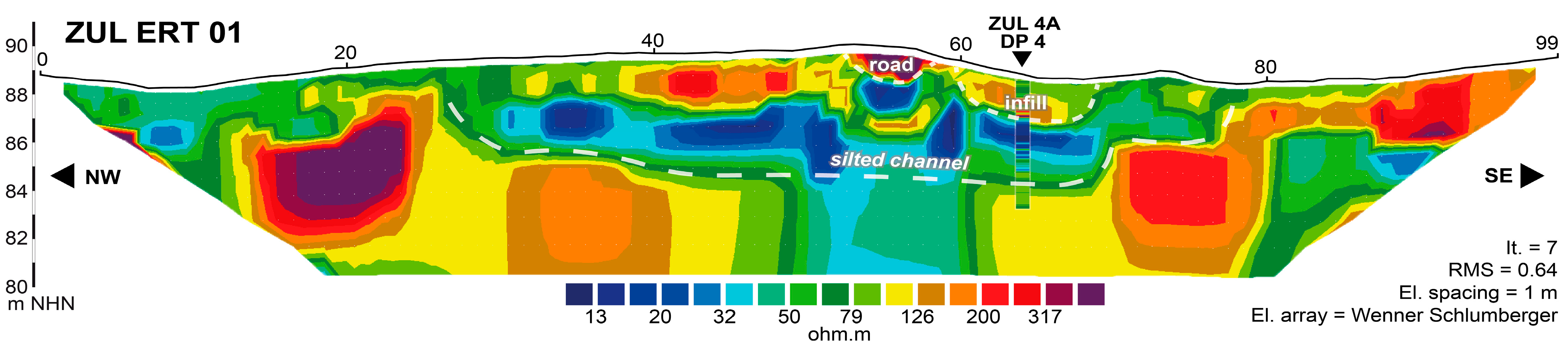
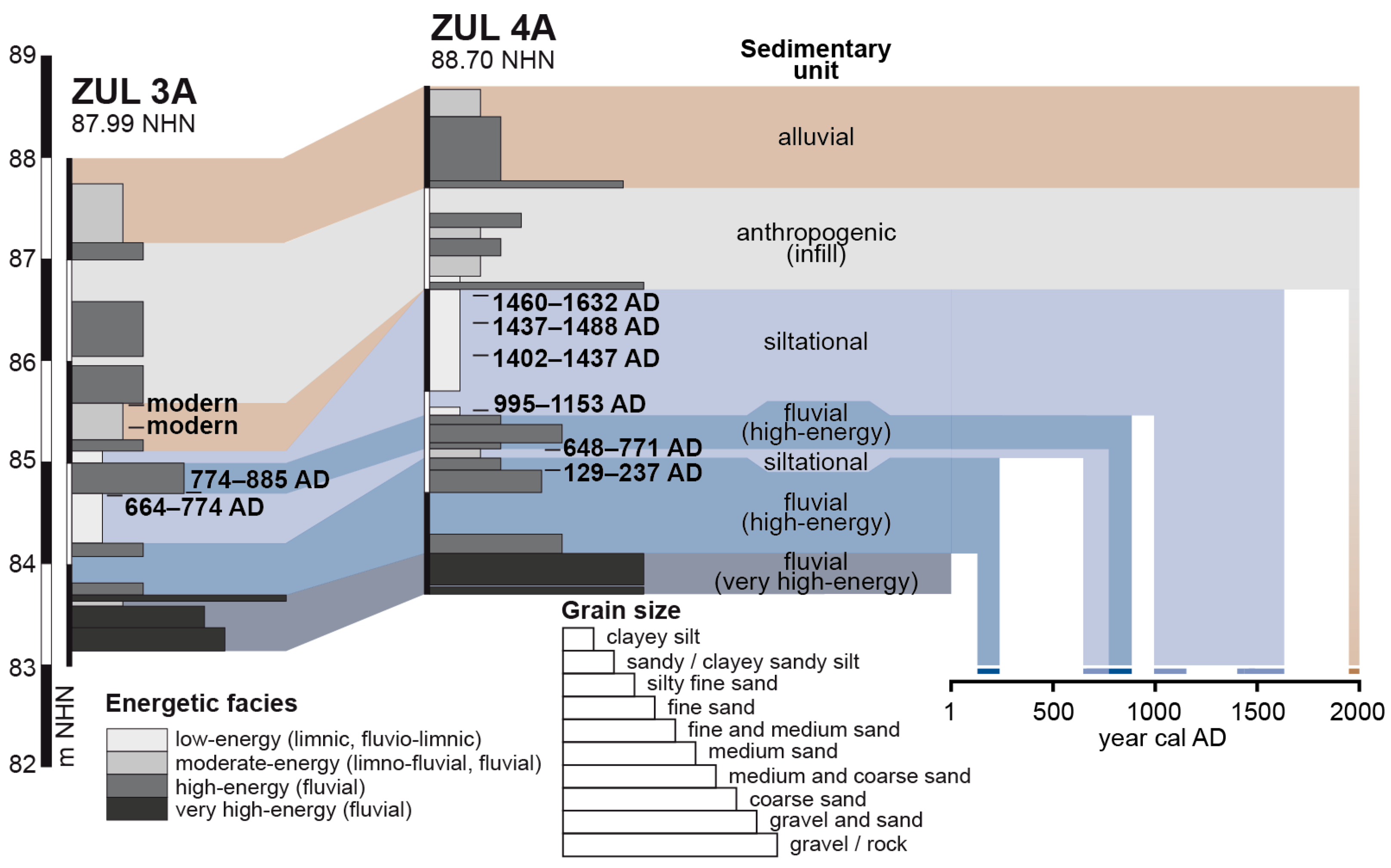
Remote sensing analyses were carried out using the digital elevation model (DEM) provided by the Hessische Verwaltung für Bodenmanagement und Geoinformation [28] derived from light detection and ranging (LiDAR) data. The DEM has a 1 m grid with a precision of 0.3 m. Concerning the georeferenced elevation, the accuracy of the raster element positioning is ± 0.15 m for vegetation-free and ± 0.3 m for wooded areas. The use of old maps and other historical depictions proved to be a valuable resource for the detection of changes in the fluviosphere.
Our geoarchaeological approach is based on geophysical prospection followed by direct push (DP) sensing and sediment coring at the most suitable sites. Posselt & Zickgraf Prospektionen GbR (Marburg), commissioned by the Hessen State Office for Monument Preservation, already conducted geomagnetic prospection in 2017, which, however, did not yield interpretable results. We therefore conducted geophysical prospection using two-dimensional electrical resistivity tomography (ERT) measurements by means of the multi-electrode device GeoTom MK1E100 with 100 electrodes in a Schlumberger configuration and an electrode spacing of 1 m. ERT data were inverted with the Res2DInv software version 3.58.20. Along the ERT transect, direct push in situ logging was conducted using the HPT K6050 hydraulic profiling tool (HPT, Geoprobe) in combination with a 540MT system (Geoprobe) mounted on an automotive drill rig type RS 0/2.3 (Nordmeyer). HPT sensing included electrical conductivity, which was measured at a vertical resolution of 2 cm using four electrodes in a Wenner configuration. To ensure the direct comparability of DP electrical conductivity values (mS/m) with ERT data (Ωm), the DP electrical conductivity data were converted into electrical resistivity values (Ωm). Additionally, two sediment cores were retrieved using the RS 0/2.3 drill rig (Nordmeyer) and a closed auger head with plastic inliners (5 cm in diameter). Sediment cores were opened in the laboratory, where parameters such as grain size, colour and carbonate content were analysed systematically [29,30]. A total of 10 plant fragment samples were collected from both sediment cores for accelerator mass spectrometry (AMS) radiocarbon dating, which was carried out at the Curt-Engelhorn-Zentrum Archäometrie gGmbH Mannheim (lab code: MAMS). Radiocarbon ages were calibrated using the CALIB software version 8.20 in combination with the IntCal20 calibration curve [31,32].

4. Results

The DEM shows a broad range of archaeological structures and channels (Figure 2) which, so far, can only be dated by comparing them to the oldest illustrations of the Zullestein site going back to the 17th century [33,34].
Geoarchaeological investigations were carried out in the immediate surroundings of the Zullestein. The ERT transect ZUL ERT 01 was measured in a NW-SE direction west of the site (Figure 2). The depth section exhibited comparatively high electrical resistivity values (>79 Ωm) at its base. Between 28 m and 87 m, low resistivity values (<40 ohm.m) emerged above ca. 69 m NHN. Above ca. 87 m NHN towards the surface, maximum resistivity values were measured between 32 m and 67 m and between 77 m and 97 m. At the greatest distance from the Zullestein, relatively low resistivity values (<50 ohm.m) appeared. High-resolution DP measurements at the ZUL DP 4 site corroborate the general picture drawn by ERT data (Figure 3).
The sediment core ZUL 3A was drilled to a depth of 5 m below ground surface (m b.s.), the coring site being located 40 m north of the Zullestein main building and 40 m southwest of the present course of the River Weschnitz (Figure 2 and Figure 4). From the base of the sediment core to 4.30 m b.s., pieces of gravel up to 5 cm in diameter were found embedded in grey sand. This layer was covered by a well-sorted grey silty sand, which merged into a grey clayey silt with fine sandy and organic laminae above 3.79 m b.s. A distinct transition to rusty grey, well-sorted medium sand was found at 3.30 m b.s. At the base of the third metre, we found a thin layer of brown to grey clayey silt followed by thick layers of poorly sorted material between 2.99 m b.s. and the surface. From 2.88 b.s. to 2.41 b.s., this material had a brown colour and contained some pieces of charcoal, wood and rock. Up to 1.88 m b.s., it contained numerous pieces of gravel, rock and wood remains with a diameter up to 3 cm. The subsequent light beige section between 1.88 m and 0.83 m b.s. showed a significantly reduced skeleton fraction. In the uppermost layer, rock fragments, gravels and ceramic shards were embedded in a brown-coloured silt-dominated matrix.
The sediment core ZUL 4A was drilled 50 m northwest of the Zullestein main building at profile metre 64 of ERT transect ZUL ERT 01 (Figure 2, Figure 3 and Figure 4). From its base at 5.00 m b.s. to 4.60 m b.s., the sediment core consisted predominantly of gravel. Up to 3.66 m b.s., we found well-sorted grey sand with numerous plant and wood fragments and a ceramic shard at 3.77 m b.s. This layer was overlain by grey silty clay up to 3.57 m b.s., where a distinct transition to rust-coloured medium to coarse sand with an elevated skeleton fraction was encountered. Further up-core, we found well-sorted clayey silt from 3.24 m b.s. The lower half of this silty section was grey and contained wood remains, mollusc fragments and plant remains around 2.66 m b.s., while the upper half was rust-coloured due to iron stains and nodules. The uppermost 2 m of the sediment core exhibited poorly sorted sandy silts with an elevated content of embedded rock fragments, pieces of charcoal and ceramic fragments.
The results of AMS radiocarbon dating of ten samples are provided in Table 1.

5. Discussion

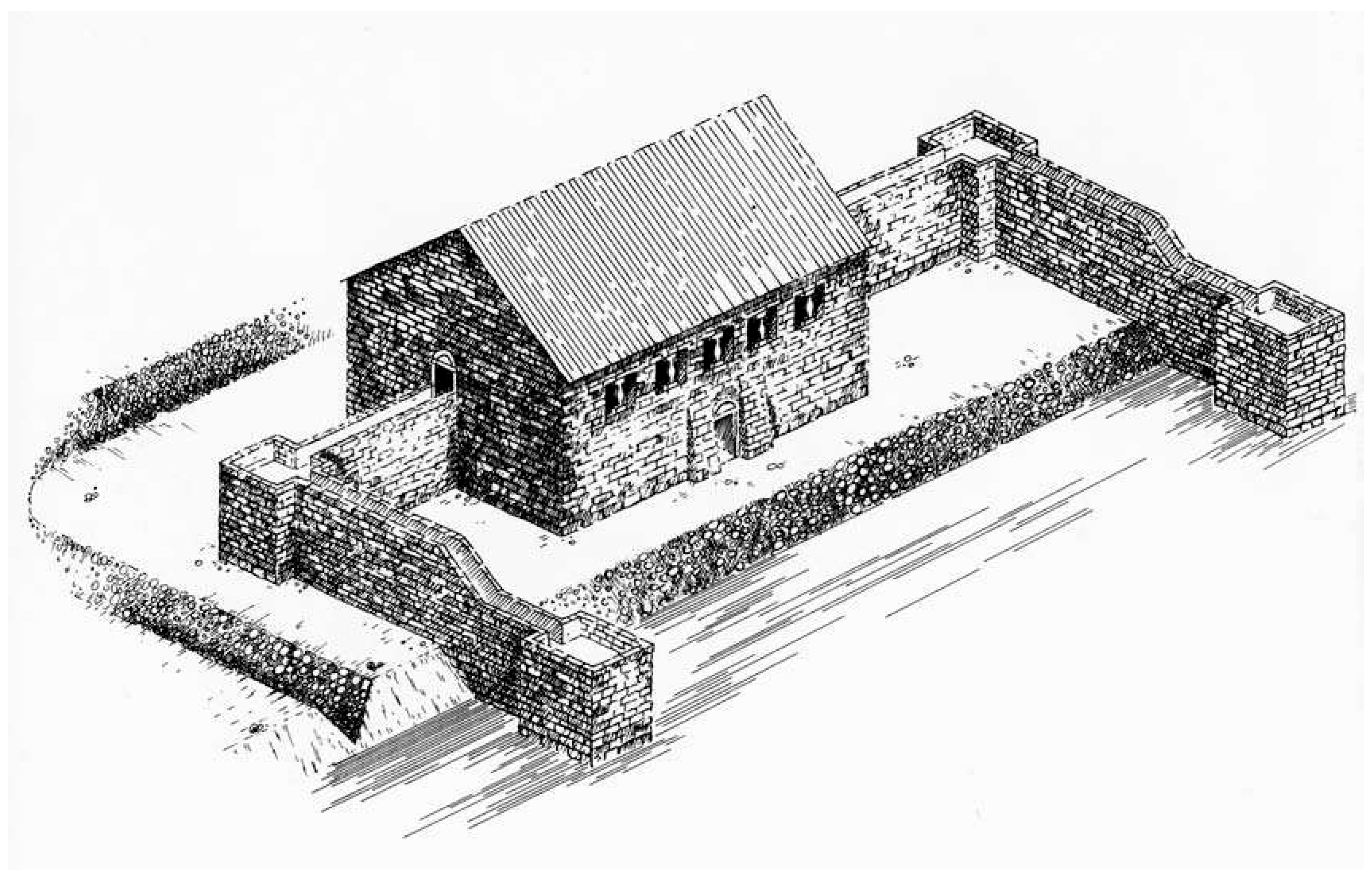
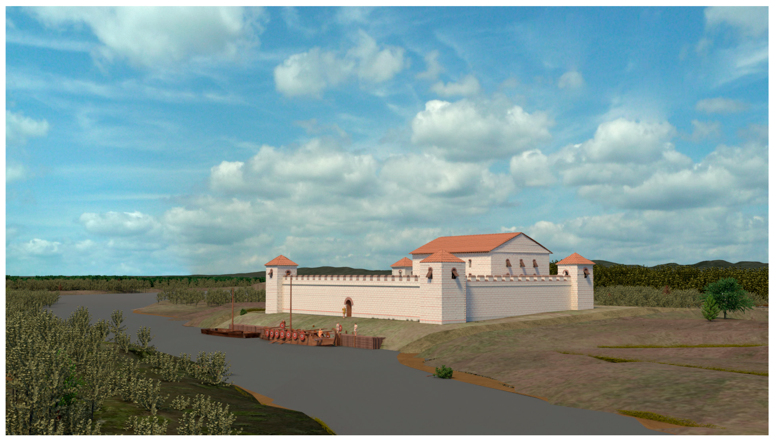
5.1. Geoarchaeological Reconstruction of the Zullestein Surroundings

Given the orientation of the Zullestein burgus and its function as a Roman fortification and landing place, the site must have been originally located at a SW-NE running water course. In fact, the ERT transect ZUL ERT 01 reveals a flat-bottomed, approximately 40 m wide U-shaped zone of low resistivity values (Figure 3), which in the Hessische Ried is typically associated with the siltation facies of a fluvial channel [35]. Both sediment cores ZUL 3A and ZUL 4A were drilled within this channel structure and documented three phases of fluvial activity and two phases of subsequent siltation (Figure 3 and Figure 4). Gravel-dominated sediments found at the base of both sediment cores were interpreted as a (very) high-energy fluvial phase based on the very coarse grain size. The presence of large, well-rounded gravel suggests that the sediment was deposited by a river with a higher discharge than the River Weschnitz, which has a median discharge of only 2.4 m3/s [36] and whose coarse sediments are concentrated at the Weinheim alluvial fan where the river leaves the Odenwald mountains, entering the flat Upper Rhine Graben. Moreover, the approximately 40 m wide channel structure observed in the ERT transect ZUL ERT 01 is much wider than the River Weschnitz, which presently has a maximum width of approximately 15 m. As the River Rhine consisted of multiple, comparatively shallow channels prior to the modern era and lacked the single-terrace pattern it exhibits today [37,38,39], it is highly probable that the channel structure visible in the ERT transect ZUL ERT 01, as well as the gravel at the base of both sediment cores, is associated with a silted-up branch of the River Rhine.
The subsequent layer of fluvial sand, which is characterised by a finer grain size and much better sorting, is dated to the 2nd/3rd century cal AD (Figure 5), which is at least 150 years before the construction of the burgus. We suggest that the sediment was deposited by a secondary river channel of the River Rhine. This assumption is supported by the fact that there is no erosional unconformity between basal gravel and subsequent sandy sections found in the two sediment cores. It may be assumed that even this early phase of fluvial activity is due to man-made manipulations of the fluvioscape, most probably to a diversion or re-activation of a (truncated?) Rhine channel. This seems probable in the light of early Roman findings from the 1st century AD that predate the construction of the burgus itself. Taking into account observations from early excavations, where the fortress walls leading into the water could not be verified, we were able to produce a new visualisation. According to the known archaeological features and by comparison with similar fortifications on the Danube River, it shows a waterfront with a closed fortress wall and a landing stage in front (Figure 6).
Silt-dominated sediments found in the fourth metre b.s. at each coring site indicate a subsequent siltation phase in the 7th/8th century AD. Fluvial activity in front of the Roman burgus must have stopped beforehand, which could be explained by the end of the Roman presence resulting in a water management hiatus. At the coring site ZUL 3A, there appears to have been temporary and weak water inflow at times, as evidenced by thin layers of embedded fine sand (Figure 5).
Rust-coloured sands in the fourth metre b.s. found at both coring sites document the subsequent and final phase of fluvial activity in the immediate forefront of the Zullestein building. This phase began in the 8th/9th century cal AD (Figure 5), coinciding with Lorsch Abbey coming into possession of the villa Zullestein in 846 AD (Codex Laureshamensis, Urkunde 27, Reg. 3327) [40]. Especially at coring site ZUL 4A, the fluvial phase comes along with an increased amount of fine gravel, which reflects an increased flow velocity. In contrast to the basal gravels and sands which we attribute to the River Rhine, we suggest that the rust-coloured sands were deposited by the River Weschnitz. It seems as if the river course was manipulated towards the front of the Zullestein building as the sediments there represent partly eroded soil material from the nearby middle section of the Weschnitz catchment.
The medieval phase of fluvial activity stops by the 10th/12th century cal AD, marking the onset of the final siltation phase. Calibrated radiocarbon dates reveal that this siltation phase took place between the 10th/12th and 15th/17th centuries cal AD (Figure 5). This coincides with the time of use of the historically documented Burg Stein phase between 1086 AD and 1657 AD [7,11,41]. We further assume that the thick layers of silt represent sediment from the surrounding ditches depicted in both 17th-century illustrations of Burg Stein before its destruction [33,34]. It seems likely that the ditches were dredged to prevent siltation and maintain sufficient water depth, as indicated by the rise in sedimentation rate from the 15th century cal AD onwards. The colour changes in the upper section of the siltation phase are possibly due to post-sedimentary oxidation processes resulting from groundwater level fluctuations. Assuming that the upper edge of the siltation unit at coring site ZUL 4A marks the minimum water surface for the final siltation phase, a minimum water depth of 1.2 m for the 10th/12th centuries cal AD can be assessed.
The upper sections of both sediment cores represent disturbed layers comprising building rubble and other anthropogenic markers such as medieval to modern-era ceramic shards and glass mixed with alluvial sediment. Radiocarbon ages from this anthropogenic layer indicate that the infill took place after 1950 (Figure 5), most probably in conjunction with archaeological excavations conducted between 1970 and1972.

5.2. DEM and Historical Data Analyses

Although the topography of the Zullestein site has been extensively altered during and since its final destruction in the 17th century, the comparison of contemporary illustrations [33,34] with the modern-day DEM [28] reveals notable similarities, enabling the georeferencing of some architectural and fluvial structures from this period. The Vauban-style verschanzte Linie [42] (earthworks) is easily identifiable as a positive landform in the DEM (red colouring in Figure 7). An Außengraben (outer ditch) accompanies the verschanzte Linie on its southwest-facing side (green colouring in Figure 7), which is typical of this type of defensive structure [42]. While the depiction of this ditch varies between different sketches, they convey a convex form in the southeast, which can be detected in the DEM. Further ditches are shown surrounding the Zullestein (yellow and purple colouring in Figure 7). The illustrations corroborate the timeline of our geoarchaeological investigations for the sediment cores ZUL 3A (inner surrounding ditch) and ZUL 4A (outer surrounding ditch) (Figure 6). The right bank of the River Rhine has apparently shifted approximately 500 m towards the northwest between the 17th century and today (blue dotted line in Figure 7). By combining the geoarchaeological results from the ERT transect ZUL ERT 01 (Figure 4) with the geochronostratigraphy derived from sediment cores ZUL 3A and ZUL 4A (Figure 6), we further suggest that the right bank of the River Rhine shifted approximately 100 m towards the northwest between the burgus phase in the 4th century and the final phase of the lowland castle in the 17th century (blue dotted line in Figure 7). Merian’s [34] illustration of the River Weschnitz accurately reflects the current river course (blue colouring in Figure 7), thus showcasing that the Weschnitz was at least partially rectified by the middle of the 17th century and that this river section likely has not changed its course for over 350 years. Merely the mouth itself is not at the same location because the right bank of the River Rhine has shifted toward the northwest.
Furthermore, the DEM shows linear depressions to the south of Zullestein, revealing River Weschnitz palaeochannel structures. Where the modern Weschnitz makes an almost right-angled bend from a western to a northern direction, a palaeochannel continues in a western direction and then takes a right-hand bend towards the Zullestein site in a wide radius (black dotted line in Figure 7). Here, it abruptly changes direction and, instead of passing the forefront of the Zullestein site, flows counterclockwise around the southern edges (green colouring in Figure 7). Based on our geoarchaeological investigations, we suggest that this last section (green colouring in Figure 7) did not exist before the 10th/12th centuries cal AD. Rather, the Weschnitz would have continued towards the northeast in a straight path, flowing past the forefront of the Zullestein between the 8th/9th and 10th/12th centuries cal AD, depositing fluvial sand (Figure 4 and Figure 5).
Due to their unnatural angles, the Weschnitz palaeochannels generally appear to be man-made, but with one exception; a seemingly more naturally meandering depression can be found parallel to the rather straight palaeochannel in the south (black dotted line in Figure 7). Interestingly, this meandering palaeochannel is accompanied by an elder dyke, today out of use, which is only 1 m high. Also, the main dyke which has a height of over 4 m and is still in use today partly follows the shapes of the man-made palaeochannels. We, therefore, conclude that the existence of both the natural and the man-made river channels constitutes a terminus post quem for dyke construction. The construction or expansion of the Weschnitz and Rhine dykes, as they appeared before modern renovation or raising in the early 21st century, is dated by historical records to the early 19th century and, thus, to the context of the Rhine correction. Archaeologically, this expansion process can be identified at two points, as the wooden substructures of the culverts can be dated dendrochronologically. Northwest of the Zullestein on the Rhine dyke, the timbers of the substructure were felled in 1824 [43], while the construction of the culvert through the eastern Weschnitz dyke north of Biblis yielded dendrochronological data from after 1810 to 1835 [44] (brown tree discs in Figure 7).

6. Conclusions

The re-evaluation of the results of archaeological excavations from the 1970s led to a revised reconstruction of the appearance of the late Roman fort, which is visualised in Figure 6. A medieval re-occupation of the site can be dated back to the 7th or 8th century on the basis of the ceramic finds. In the medieval period, the role of the site changed from a trading port for the Lorsch Abbey at the mouth of the Weschnitz to a lowland castle of the Bishops of Worms on the right bank of the Rhine.
Geoarchaeological studies in the vicinity of the Zullestein site revealed three distinct phases of fluvial activity. While the oldest remains undated, the second can be dated to the Roman period and possibly goes back to old river manipulation measures. Both phases are most likely associated with the River Rhine. The last phase of fluvial activity can be dated to the Early Middle Ages and appears to be related to the River Weschnitz as part of the formation of the human-made Weschnitz fluvioscape under the reign of the Carolingian Lorsch Abbey. Moreover, we found sedimentary evidence of a water-filled ditch between the 10th/12th and 15th/17th centuries AD when the Burg Stein was still in use at the same site. Subrecent-to-modern alterations of the subsurface conditions have occurred, for example by construction measures and archaeological excavations, obstructing the geomorphological and geoarchaeological reconstruction of the immediate surroundings of the Zullestein site. However, some traces of the 17th century Zullestein landscape can still be found in the modern topography. Based on DEM data, we were able to localise several architectural and fluvial structures depicted in contemporary sketches while corroborating geoarchaeological results. Evidently, the artificially straightened course of the River Weschnitz already existed in the 17th century, revealing early, possibly even ancient river regulation measures.
The combination of geoarchaeological investigations, re-evaluations of archaeological excavations and remote sensing in connection with contemporary sketches provides a valuable alternative for archaeological investigation if further excavations are not possible, e.g., due to nature conservation measures or high groundwater level.

Supplementary Materials

The following supporting information can be downloaded at: https://www.mdpi.com/article/10.3390/heritage8050180/s1.

Author Contributions

Conceptualization, R.P., E.A., T.B. and A.V.; methodology, O.B., B.M., E.A. and A.V.; investigation, B.M., P.F., T.W. and A.V.; data curation, B.M., P.F., T.W. and A.V.; writing—original draft preparation, R.P., E.A., T.B. and A.V.; writing—review and editing, R.P., E.A., T.B., B.M., O.B., P.F., T.W. and A.V.; visualisation, E.A.; supervision, A.V.; project administration, R.P., T.B. and A.V.; funding acquisition, R.P., T.B., O.B., B.M. and A.V. All authors have read and agreed to the published version of the manuscript.

Funding

Geoarchaeological research was part of the project entitled “Die Flusslandschaft der Weschnitz und ihre Wechselwirkung mit dem Kloster Lorsch” (project number 509913470) as part of the “SPP 2361: Auf dem Weg zur Fluvialen Anthroposphäre” (project number 460849764) funded by the German Research Foundation (Deutsche Forschungsgemeinschaft, DFG). The pilot research “Verborgenes Kulturerbe Zullestein” (project number ZUK49/Ü3.1.45) was funded by the Heidelberg University’s Excellence Initiative.

Data Availability Statement

The original contributions presented in this study are included in the article. Further inquiries can be directed to the corresponding authors.

Acknowledgments

We thank Lea Obrocki for her participation in field work and discussion. Many thanks to Peter Steffens for discussion and permissions. We are grateful for the authorisation by the Higher Nature Conservation Authority at the Darmstadt Regional Council (Obere Naturschutzbehörde, Regierungspräsidium Darmstadt) to carry out the survey in the Steiner Wald nature reserve.

Conflicts of Interest

The authors declare no conflicts of interest.

Abbreviations

The following abbreviations are used in this manuscript:
ADAnno Domini
b.s.Below surface
calCalibrated
DEMDigital elevation model
DPDirect push
ERTElectrical resistivity tomography
HPTHydraulic profiling tool
NHNNormalhöhennull (elevation above the German vertical datum)

References

  1. Haass, J.H. I. Bogen Der Angekündigten Situations-Charte, Aufgenommen Und Gezeichnet Durch Haass, Artillerie-Lieutenant Zu Darmstadt (Kartenwerk Zum 1. Koalitionskrieg). Blatt 7: Westhofen, Worms Und Wachenheim 1795. Available online: http://www.landesarchiv-bw.de/plink/?f=1-1297816 (accessed on 14 May 2025).
  2. Eckhardt, C.L.P.; Hirsch, A. Nördliche Fortsetzung Der Topographischen Charte von Schwaben. Blatt Mannheim 1833. Available online: https://arcinsys.hessen.de/arcinsys/digitalMediaViewer.action?archivalDescriptionId=3466536&selectId=3902839 (accessed on 14 May 2025).
  3. Jorns, W. Zullenstein: Ein Beitrag zur Kontinuität von Bauwerken. In Deutsche Königspfalzen. Beiträge zu Ihrer Historischen und Archäologischen Erforschung; Fleckenstein, J., Ed.; Veröffentlichungen des Max-Planck-Instituts für Geschichte; Vandenhoeck & Ruprecht: Göttingen, Germany, 1979; Volume 3, pp. 111–135. [Google Scholar]
  4. Jorns, W. Der spätrömische Burgus mit Schiffslände und die karolingische Villa Zullestein. Archäologisches Korresp. 1973, 3, 75–80. [Google Scholar]
  5. Jorns, W. Der Spätrömische Burgus Zullestein Mit Schiffslände, Nördlich von Worms. In Actes du IXe Congrès International d’Études sur les Frontières Romaines; Pippidi, D.M., Ed.; Editura Academiei: Bucuresti, Romania, 1974; pp. 427–432. [Google Scholar]
  6. Jorns, W. Die Burg Stein: Bericht über die Archäologischen Untersuchungen 1971-73. Geschichtsblätter Kreis Bergstraße 1978, 11, 35–72. [Google Scholar]
  7. Kunz, R.; Jorns, W.; von Brockhusen, H.J. Die Burg Stein; Veröffentlichungen des Amts für Bodendenkmalpflege Darmstadt; Selbstverlag: Darmstadt, Germany, 1971. [Google Scholar]
  8. Kunter, M. Frühkarolingische Skelettreste vom Zullestein, Gem. Nordheim, Lkr. Bergstraße. Z. Für Morphol. Und Anthropol. 1974, 65, 305–323. [Google Scholar] [CrossRef]
  9. Kunter, M. Frühkarolingische Skelettreste vom Zullestein, Gem. Nordheim, Lkr. Bergstraße. Ver. Für Heimatgeschichte Nord. 2006, 20, 360–364. [Google Scholar]
  10. Herrmann, F.-R. Der Zullenstein an Der Weschnitzmündung: Führungsblatt Zu Dem Spätrömischen Burgus, Dem Karolingischen Königshof Und Der Veste Stein Bei Biblis-Nordheim, Kreis Bergstraße; Archäologische Denkmäler in Hessen; Archäologische Denkmalpflege im Landesamt für Denkmalpflege in Hessen: Wiesbaden, Germany, 1989; Volume 82. [Google Scholar]
  11. Siemers, S.-H. Von der karolingischen Handelssiedlung “Zullestein” zur Festung “Zum Stein” bei Biblis-Nordheim, Kreis Bergstrasse. Eine Auswertung der Funde der Ausgrabung “Schloßbuckel”. Ph.D. Thesis, Johannes Gutenberg-Universität Mainz, Mainz, Germany, 2001. [Google Scholar]
  12. Siemers, S.-H. Von Der Karolingischen Handelssiedlung “Zullestein” Zur Festung “Zum Stein” Bei Biblis-Nordheim, Kr. Bergstrasse. Archäologisches Nachrichtenblatt 2002, 7, 336–339. [Google Scholar]
  13. Siemers, S.-H. Gelbes Blei aus dem Oberrheingraben. Ein Aussergewöhnlicher Glasbecher aus der Burg Stein (Gem. Biblis-Nordheim/ Kr. Bergstraße). 2007. Available online: https://www.academia.edu/5953650/Gelbes_Blei_aus_dem_Oberrheingraben (accessed on 14 May 2025).
  14. Schwarz, K. Die römische Schiffslände Zullestein. Aspekte zur spätrömischen Grenzverteidigung in den Nordwestprovinzen unter besonderer Berücksichtigung der Ländeburgi. Ph.D. Thesis, Johannes Gutenberg-Universität Mainz, Mainz, Germany, 2009. [Google Scholar]
  15. Bakker, L. Die Spätrömische Schiffsländen Am Rhein. Die Burgi von Niederlahnstein Und Biblis-”Zullestein”. In Berichte zur Archäologie an Mittelrhein und Mosel; Wegner, H.-H., Ed.; Gesellschaft für Archäologie an Mittelrhein und Mosel e.V.: Koblenz, Germany, 2014; Volume 20, pp. 33–155. ISBN 978-3-9811687-9-2. [Google Scholar]
  16. Becker, T.; Janotka, N.; Mächtle, B.; Obrocki, L.; Prien, R.; Vött, A. Das neue Bild vom alten Burgus. Neue Forschungen zum “Zullestein” bei Biblis (Lkr. Bergstraße) und zu dessen Umfeld. In hessenARCHÄOLOGIE 2019; hessenARCHÄOLOGIE, Ed.; Jahrbuch für Archäologie und Paläontologie in Hessen; wbg Theiss: Darmstadt, Germany, 2020; pp. 133–137. ISBN 978-3-8062-4224-9. [Google Scholar]
  17. Prien, R. Der spätantike burgus von Ladenburg-eine Neubewertung. In LOPODUNUM VII: Ladenburg und der Lobdengau zwischen ‚Limesfall‘ und den Karolingern; Prien, R., Witschel, C., Eds.; Forschungen und Berichte zur Archäologie in Baden-Württemberg; Reichert Verlag: Wiesbaden, Germany, 2020; Volume 17, pp. 121–146. ISBN 978-3-95490-707-6. [Google Scholar]
  18. Becker, T. Historische Gewässernutzung in Südhessen. Das Landgraben- Und Das Weschnitz-Projekt. Denkmal Hess. 2023, 2, 46–49. [Google Scholar] [CrossRef]
  19. Henselowsky, F.; Becker, T.; Bubenzer, O.; Mächtle, B.; Schenk, G.J.; Vött, A. Wechselbeziehungen Zwischen Der Flusslandschaft Der Weschnitz Und Dem Kloster Lorsch. Interdisziplinäres Forschungsprojekt „Auf Dem Weg Zur Fluvialen Anthroposphäre“ Im Landkreis Bergstraße. In HessenARCHÄOLOGIE 2023; Jahrbuch für Archäologie und Paläontologie in Hessen; wbg Theiss: Darmstadt, Germany, 2024; pp. 294–299. ISBN 978-3-89822-354-6. [Google Scholar]
  20. Rolfe, J.C. Ammianus Marcellinus: History. Books 27–31. Excerpta Valesiana; Loeb Classical Library; Harvard University Press: Cambridge, MA, USA, 1939; Volume 331. [Google Scholar]
  21. Saylor Rodgers, B. Symmachus. Oration II. To Valentinian. 1 January 370 2015. Available online: https://www.uvm.edu/~bsaylor/ (accessed on 14 May 2025).
  22. Prien, R.; Witschel, C. Zwischen Backofen und Burgus. Überlegungen zur Rolle von Lopodunum im Gefüge des spätantiken Grenzraums am Unteren Neckar. In Von Hammaburg nach Herimundesheim. Festschrift für Ursula Koch; Wieczorek, A., Wirth, K., Eds.; Mannheimer Geschichtsblätter: Sonderveröffentlichung; Verlag Regionalkultur: Ubstadt-Weiher, Germany, 2018; Volume 11, pp. 67–76. ISBN 978-3-95505-106-8. [Google Scholar]
  23. Bockius, R. Die Spätrömischen Schiffswracks Aus Mainz: Schiffsarchäologisch-Technikgeschichtliche Untersuchung Spätantiker Schiffsfunde Vom Nördlichen Oberrhein; Monographien des RGZM.; Verlag des Römisch-Germanischen Zentralmuseums: Mainz, Germany, 2006; ISBN 978-3-96929-356-0. [Google Scholar]
  24. Appel, E.; Becker, T.; Wilken, D.; Obrocki, L.; Fischer, P.; Willershäuser, T.; Henselowsky, F.; Vött, A. The Roman Burgus at Trebur-Astheim and Its Relation to the Schwarzbach/Landgraben Watercourse (Hessisches Ried, Germany) Based on Geophysical and Geoarchaeological Investigations. Z. Für Geomorphol. 2024. preprint. [Google Scholar] [CrossRef]
  25. Appel, E.; Becker, T.; Schäfer, H.; Scholz, M.; Vött, A.; Wilken, D. Ergebnisse aus dem DFG-Projekt “Landgraben”. Neue Untersuchungen im Umfeld des römerzeitlichen Schiffsländeburgus von Trebur-Astheim. In hessenARCHÄOLOGIE 2024; Jahrbuch für Archäologie und Paläontologie in Hessen; wbg Theiss: Darmstadt, Germany, 2025; in print. [Google Scholar]
  26. Heising, A. Der Schiffslände-Burgus von Trebur-Astheim: Schicksal einer Kleinfestung in Spätantike und frühem Mittelalter. In Das Gebaute und das Gedachte: Siedlungsform, Architektur und Gesellschaft in Prähistorischen und Antiken Kulturen; Raeck, W., Steuernagel, D., Eds.; Frankfurter archäologische Schriften; Verlag Dr. Rudolf Habelt: Bonn, Germany, 2012; pp. 151–166. ISBN 978-3-7749-3816-8. [Google Scholar]
  27. Mráv, Z. Dunakeszi-Late Roman Fortlet Along the Danube. In Guide to Hungarian Sites of the Roman Limes that Are Nominated for World Heritage Status; National Office of Cultural Heritage: Budapest, Hungary, 2011; Volume 1, ISBN 978-963-08-0841-5. [Google Scholar]
  28. Hessische Verwaltung für Bodenmanagement und Geoinformation Digitales Geländemodell (DGM1) 2023. Available online: https://gds.hessen.de/INTERSHOP/web/WFS/HLBG-Geodaten-Site/de_DE/-/EUR/ViewDownloadcenter-Start?path=3D-Daten/Digitales%20Gel%C3%A4ndemodell%20(DGM1) (accessed on 14 May 2025).
  29. Ad-hoc-Arbeitsgruppe Boden. Bodenkundliche Kartieranleitung, 5th ed.; Schweizerbart’sche Verlagsbuchhandlung: Hannover, Germany, 2005; ISBN 978-3-510-95920-4. [Google Scholar]
  30. Amelung, W.; Blume, H.-P.; Fleige, H.; Horn, R.; Kandeler, E.; Kögel-Knabner, I.; Kretzschmar, R.; Stahr, K.; Wilke, B.-M. Scheffer/Schachtschabel Lehrbuch der Bodenkunde; Springer: Berlin/Heidelberg, Germany, 2018; ISBN 978-3-662-55870-6. [Google Scholar]
  31. Reimer, P.J.; Austin, W.E.N.; Bard, E.; Bayliss, A.; Blackwell, P.G.; Bronk Ramsey, C.; Butzin, M.; Cheng, H.; Edwards, R.L.; Friedrich, M.; et al. The IntCal20 Northern Hemisphere Radiocarbon Age Calibration Curve (0–55 Cal kBP). Radiocarbon 2020, 62, 725–757. [Google Scholar] [CrossRef]
  32. Stuiver, M.; Reimer, P.J. Extended 14C Data Base and Revised CALIB 3.0 14C Age Calibration Program. Radiocarbon 1993, 35, 215–230. [Google Scholar] [CrossRef]
  33. Anonymous Wahre Abbildung deß Vesten Orthß Stein so den 21. Augusti Anno 1621. von den Spanischen Erobert, Sambt Denselben Schantzen und Schiffbrucken Daselbsten; 1621. Available online: https://nat.museum-digital.de/object/1239414 (accessed on 14 May 2025).
  34. Merian, M.; Zeiller, M. (Eds.) Topographia Palatinatus Rheni et Vicinarum Regionum; Mattheum Merian: Frankfurt am Main, Germany, 1645. [Google Scholar] [CrossRef]
  35. Appel, E.; Becker, T.; Wilken, D.; Fischer, P.; Willershäuser, T.; Obrocki, L.; Schäfer, H.; Scholz, M.; Bubenzer, O.; Mächtle, B.; et al. The Holocene Evolution of the Fluvial System of the Southern Hessische Ried (Upper Rhine Graben, Germany) and Its Role for the Use of the River Landgraben as a Waterway during Roman Times. EG Quat. Sci. J. 2024, 73, 179–202. [Google Scholar] [CrossRef]
  36. Hessisches Landesamt für Naturschutz, Umwelt und Geologie Lorsch Weschnitz Gewässerdurchfluss Tagesmittelwerte. Messstellennummer 23942300. 2025. Available online: https://www.hlnug.de/static/pegel/wiskiweb3/webpublic/#/overview/Wasserstand/station/41276/Lorsch/download (accessed on 14 May 2025).
  37. Gerlach, R.; Meurers-Balke, J.; Kalis, A.J. The Lower Rhine (Germany) in Late Antiquity: A Time of Dissolving Structures. Neth. J. Geosci. 2022, 101, e14. [Google Scholar] [CrossRef]
  38. Roggenkamp, T.; Herget, J. Middle and Lower Rhine in Roman Times: A Reconstruction of Hydrological Data Based on Historical Sources. Environ. Earth Sci. 2016, 75, 1100. [Google Scholar] [CrossRef]
  39. Schirmer, W.; Bos, J.A.A.; Dambeck, R.; Hinderer, M.; Preston, N.; Schulte, A.; Schwalb, A.; Wessels, M. Holocene Fluviatile Processes and Valley History in the River Rhine Catchment. Erdkd. Arch. Sci. Geogr. 2005, 59, 199–215. [Google Scholar] [CrossRef]
  40. Minst, K.J. Lorscher Codex: Deutsch; Urkundenbuch Der Ehemaligen Fürstabtei Lorsch; Lorscher Codex; Verlag Laurissa: Lorsch, Germany, 1966; Volume 1. [Google Scholar] [CrossRef]
  41. Landesgeschichtliches Informationssystem Hessen Burg Zullenstein, Landkreis Bergstraße. Historisches Ortslexikon 2024. Available online: https://www.lagis-hessen.de/de/subjects/idrec/sn/ol/id/13205 (accessed on 14 May 2025).
  42. Rüstow, W. Militärisches Hand-Wörterbuch. Nach Dem Standpunkte Der Neuesten Litteratur Und Mit Unterstützung von Fachmännern. M Bis Z.; Friedrich Schultheß: Zürich, Switzerland, 1859; Volume 2. [Google Scholar]
  43. Landesamt für Denkmalpflege Hessen. Archive: Außenstelle Darmstadt Nordheim 050. EV DA 2019: 0027 2019.
  44. Landesamt für Denkmalpflege Hessen. Archive: Außenstelle Darmstadt Biblis 054. EV DA 2014: 0132 2014.
Figure 1. Visualisation of the late Roman burgus at the Zullestein according to Jorns [4].
Heritage 08 00180 g001
Figure 2. The Zullestein Roman fortlet and lowland castle at the present mouth of the River Weschnitz into the River Rhine. The DEM depicts the locations of ERT transect, DP and coring sites. The structure of the exposed architectural remains can be seen in the centre.
Heritage 08 00180 g002
Figure 3. Depth section for ERT transect ZUL ERT 01 combined with results of DP EC measurements at ZUL DP 4 site.
Heritage 08 00180 g003
Figure 4. Photographs of sediment cores ZUL 3A and 4A showing sedimentary units and calibrated radiocarbon ages (2σ-intervals; see Table 1). Sedimentary units are further described in the text and classified in Figure 5.
Heritage 08 00180 g004
Figure 5. Stratigraphic transect of sediment cores ZUL 3A and ZUL 4A drilled on the river front of the Zullestein including calibrated radiocarbon ages (2σ-intervals) and sedimentary units. The timeline at the lower right depicts the ranges of calibrated radiocarbon ages (2σ) for the corresponding sedimentary units.
Heritage 08 00180 g005
Figure 6. Revised visualisation of the late Roman fortlet Zullestein (Visualisation: Roland Prien and Jürgen Süß).
Heritage 08 00180 g006
Figure 7. Comparison of building structures deduced from modern-day DEM and contemporary illustrations of the Zullestein from the late 17th century (red = verschanzte Linie (earthworks); green = Außengraben (outer ditch); yellow = outer surrounding ditch; purple = inner surrounding ditch; blue = River Weschnitz; blue dotted line = right River Rhine bank; black dotted line = old Weschnitz palaeochannels; black dots = sediment cores ZUL 3A and 4A; brown tree disc = dendrochronologically dated timber). (a) DEM [28] of the wider Zullestein study area with the Roman burgus Zullestein being located at the mouth of the River Weschnitz into the River Rhine. (b) Contemporary sketch of the Zullestein area [33]. (c) Contemporary sketch of the Zullestein area by Merian [34]. For original data, see supplementary files S1–S3. Please note that the old Weschnitz approached the Zullestein from the southwest and flowed along the northwestern face of the burgus.
Heritage 08 00180 g007
Table 1. Results of AMS radiocarbon analyses of selected samples retrieved from sediment cores ZUL 3A and ZUL 4A with 1σ- and 2σ-intervals for calibrated ages.
SampleLab. No. MAMSDepth (m b.s.)Depth
(m NHN)
Materialδ13C14C Age (BP)+/−1 σ Max-Min (cal AD)2 σ Max-Min (cal AD)
Zul 3A/17 HR 2.43427632.4385.56wood−27.7−334817modernmodern
Zul 3A/19 HR 2.65427642.6585.34wood−27.8−116818modernmodern
Zul 3A/26 HR 3.29427653.2984.7wood−30.4119920775–880774–885
Zul 3A/27 PR 3.32427663.3284.67plant fragment−28.8129421674–773664–774
Zul 4A/18 HK 2.06427672.0686.64charcoal−25.1356191478–16211460–1632
Zul 4A/20 PR/HR 2.33427682.3386.37plant fragment−26.4419191445–14691437–1488
Zul 4A/24 HR 2.65427692.6586.05wood−31.9517201409–14261402–1437
Zul 4A/28 HR 3.19427703.1985.51wood−27.4988221022–1123995–1153
Zul 4A/33 PR 3.58427713.5885.12plant fragment−28.6134920653–671648–771
Zul 4A/35 HR2 3.78427723.7884.92wood−28.6185021132–235129–237
Disclaimer/Publisher’s Note: The statements, opinions and data contained in all publications are solely those of the individual author(s) and contributor(s) and not of MDPI and/or the editor(s). MDPI and/or the editor(s) disclaim responsibility for any injury to people or property resulting from any ideas, methods, instructions or products referred to in the content.

