Article

Using Ground Penetrating Radar (GPR) to Locate the Remains of the Jaundole (New Dahlen) Castle Near Riga, Latvia

1
Department of Environmental and Energy Engineering, Duquesne University, Pittsburgh, PA 15282, USA
2
Department of Geography and Anthropology, University of Wisconsin-Eau Claire, Eau Claire, WI 54701, USA
*
Author to whom correspondence should be addressed.
Heritage 2025, 8(5), 161; https://doi.org/10.3390/heritage8050161
Submission received: 24 March 2025 / Revised: 22 April 2025 / Accepted: 24 April 2025 / Published: 5 May 2025
(This article belongs to the Special Issue Unveiling the Past: Multidisciplinary Investigations in Archaeology)

Abstract

This study investigates the subsurface remains of Jaundole Castle, a 14th-century medieval fortress located on Dole Island near Riga, Latvia. The castle, which has left no visible surface ruins, is known only from historical documents and maps. To assess whether its buried remains could be detected, a non-invasive ground penetrating radar (GPR) survey was carried out across five targeted grids. The results revealed multiple linear and circular anomalies consistent with historical records of the castle’s layout, including possible foundations of walls and towers. These findings demonstrate that GPR, when combined with historical map and image analysis, can effectively locate, and delineate lost architectural features. The integration of historical sources and geophysical data provides a replicable model for the investigation of other completely buried archaeological sites. This work contributes to the development of non-destructive prospection strategies and supports the planning of future archaeological excavations and conservation actions.

1. Introduction

The historical landscape of Dole Island, located along the Daugava River southeast of Riga, Latvia (Figure 1 and Figure 2), hosts the remains of two medieval castles: Vecdole and Jaundole. From 1184 to 1562, German feudal lords built approximately 150 castles in present-day Latvia, with 62 castles built by the Bishop or Archbishop of Riga. The exact number of castles is unknown because many collapsed or were destroyed during the Livonian and Northern Crusades, and their ruins are now completely buried [1]. Current information available on the Medieval Castles of Latvia website [2] indicates that of the 62 castles built by the Bishops or Archbishops of Riga, 34 are no longer visible on the contemporary land surface. Jaundole Castle (also known as New Dahlen) is one of these 34 [1]. See Figures S1–S5 in the supplemental materials for additional satellite, map, and drone images of the study area.
Based on historic documents, maps, and images, the general nature and location of Jaundole Castle is known. Locating the remains of any of the 34 castles that possess no surface ruins is archaeologically significant because it will add valuable architectural, structural, and, if excavated, artifactual information to the Medieval Castles of Latvia archaeological record and to the historical records of Dole Island and the Riga region. Further, this information will be an important component of future site preservation, planning, stewardship, and management after the proposed archaeological excavation is completed. This excavation will be guided by the ground penetrating radar (GPR) data generated via this research. The systematic collection, analysis, and interpretation of reflection pattern data in the presumed location of the castle will indicate locations that have a definite probability of intersecting high-value archeological excavation targets.
This study aims to (1) identify the likely location, layout, and function of Jaundole Castle through historical sources; (2) evaluate the effectiveness of ground penetrating radar (GPR) for detecting its buried remains; and (3) determine whether structural elements can be interpreted from GPR data to support future archaeological excavations. What follows is (1) a review of the historical background of the Riga region and Dole Island; (2) a timeline and iconographic descriptions of drawings, maps, and a painting related to Dole Island and Jaundole Castle; (3) the GPR methodology and results; (4) a discussion of the results; and (5) the conclusions.

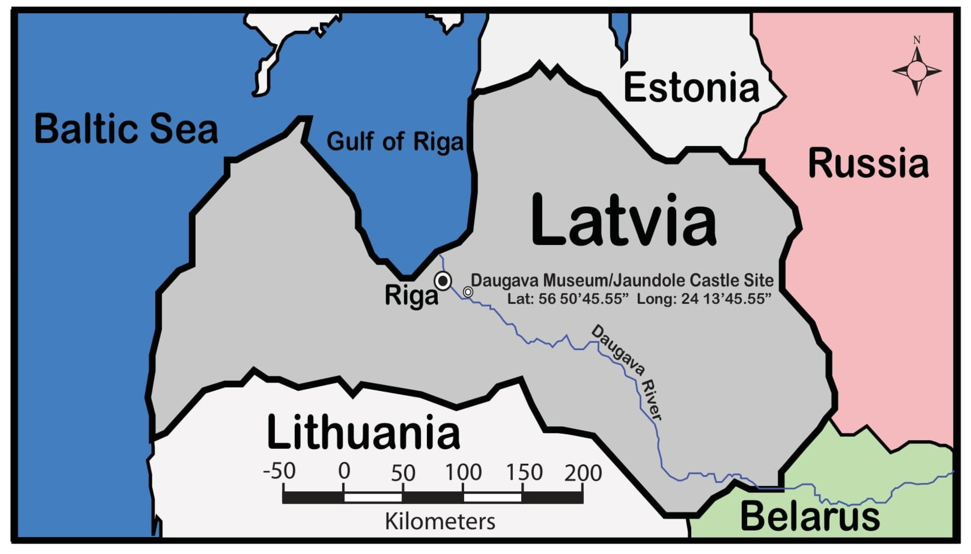
1.1. Medieval Historical Background of the Riga Region

The Medieval history of the region is first presented in the Chronicle of Henry, a narrative written in Latin by the priest Henricus Lettus in 1229. Therein, he reports events in Livonia (which roughly corresponds with the nations of Estonia and Latvia today) from the years 1180 to 1227 [3]. The Livonians are first mentioned in historical records at the beginning of the 12th century in Nestor’s Tale of Past Years, also called the Primary Chronicle. By the end of the 12th century, based on archaeological and written sources, five large regions inhabited by the Livonians existed in Latvia, which included Northern Kurzeme, Lower Daugava, Lower Gauja, Metsepole, and Idumeja [4]. The Lower Daugava Region included Riga, which was established as the center of Christian activities by St. Bishop Albert in 1201 [5]. In 1202, Bishop Albert founded the military order of the Livonian Brothers of the Sword, whose creation was sanctioned by Pope Innocent III in 1204. The members of this order were essentially warrior monks who, in 1236, merged with the Teutonic Order as an autonomous branch known as the Livonian Order [6,7]. By the end of the 13th century, the Livonian Order had conquered the region as part of the Livonian Crusade, which lasted from 1193 to 1290. This Crusade consisted of various military Christianization campaigns as part of the Papal-sanctioned Northern Crusades of the 12th and 13th centuries [8].

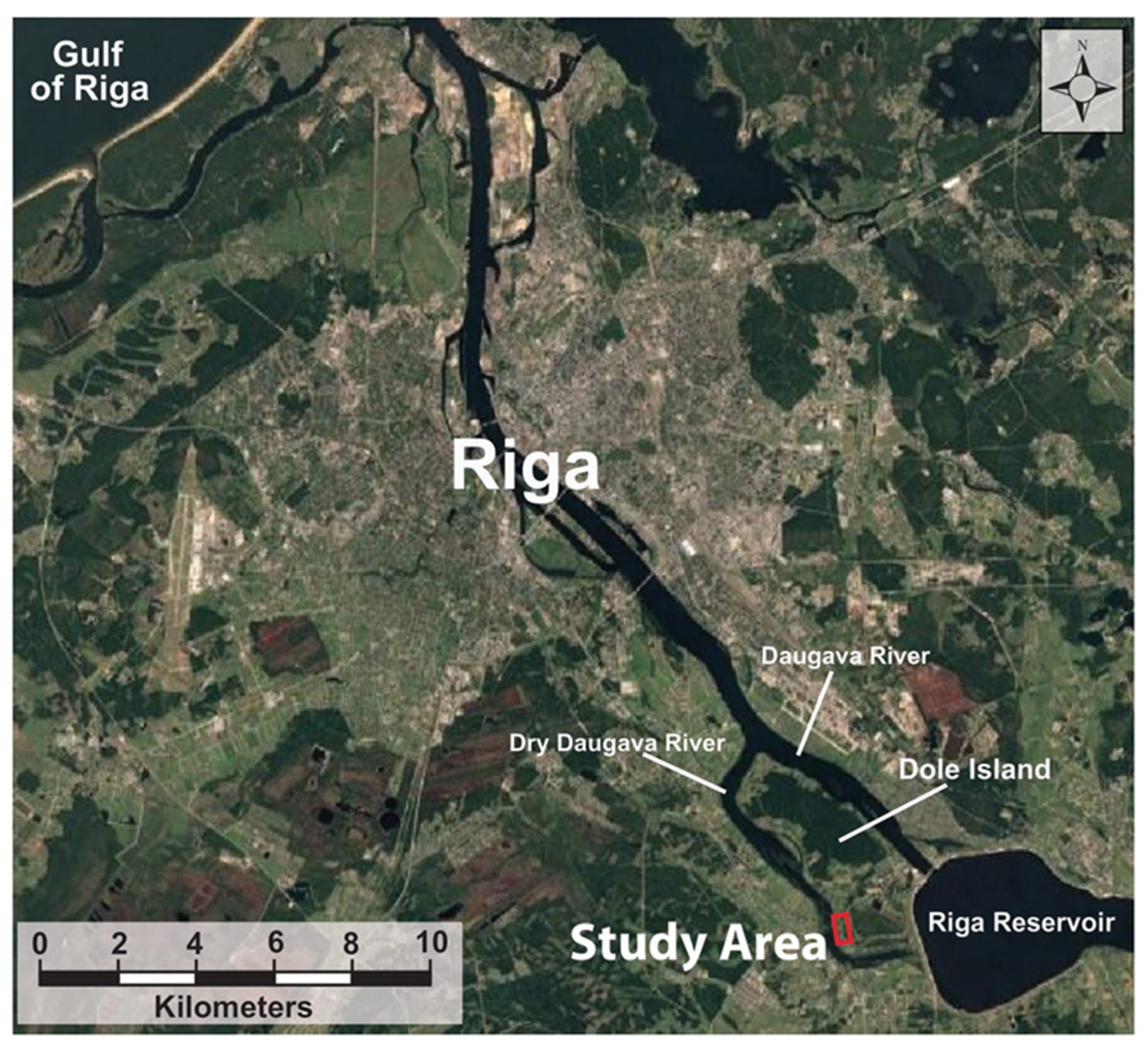
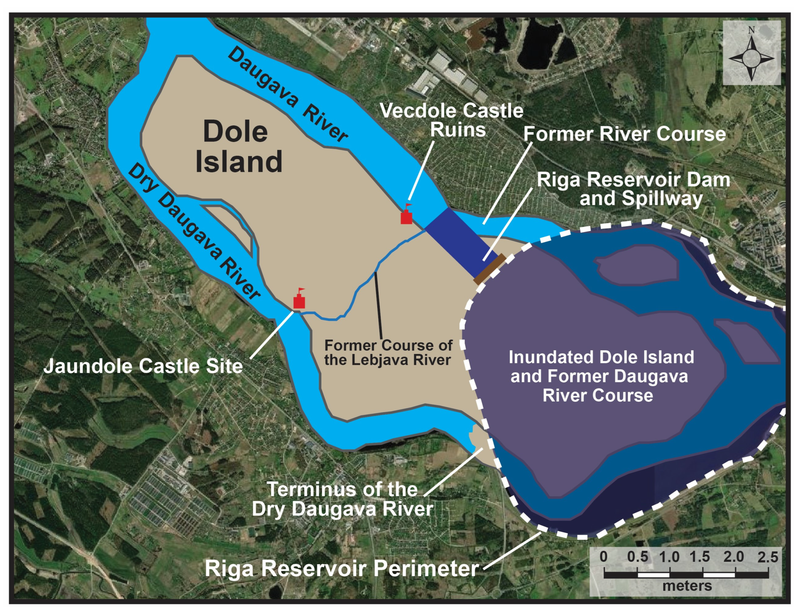
1.2. Dole Island, the Dry Daugava and Daugava Rivers, and Riga Reservoir

Dole Island was once the largest island on the Daugava River until the Riga Reservoir was created in 1974, which inundated the southeast portion of the island [9] (Figure 2 and Figure 3). Dole Island exists because two channels of the Daugava River are present on the northeast and southwest sides of the island. The northeast channel, which flows from southeast to northwest, is the main active channel, and the southwest channel, along which the study area is located, is referred to as the Dry Daugava River because, in the contemporary landscape, it does not reconnect with the main Daugava River channel or, since 1974, the Riga Reservoir. The formation of the Dry Daugava channel is most likely related to ice dams that formed during the final melting phases of the Weichselian event at the transition between the Pleistocene–Holocene glacial transition about 11,000 years ago. These events caused all or part of the river channel to change course and form an alternate channel that bypassed the ice jams on the main channel [10].
The creation of the Riga Reservoir and the inundation of the southeast portion of Dole Island decreased the exposed length of the island by approximately 40%, from 9 km to 5.2 km (Figure 3). The grounds on which the Daugava Museum was established in 1977 and where Jaundole Castle was once located were not affected by this flooding, nor was the former course of the now-dry Lebjava River (Figure 3). The creation of the Riga Reservoir also did not affect the site where the Vecdole Castle once stood on the opposite side of the island.
The Daugava and Dry Daugava River channels merge at the north end of Dole Island. The inundation of the main channel brought about by the construction of the Riga Reservoir dam submerged two smaller islands (compared to Dole Island) under the waters of the reservoir at the northeast edge of the island and cut off the connection between the Dry Daugava channel and the now submerged main channel three km east of the western edge of the Daugava Reservoir (Figure 3).

2. Historical and Iconographic Description

Dole Island has had a long and diverse cultural history. The lower reaches of the Daugava River in the Mesolithic and Neolithic periods were sparsely populated until the second half of the Early Bronze Age (1800–1100 BC). By the Late Bronze Age (1100–500 BC), local communities reached their highest level of development, having switched completely to animal husbandry and agriculture, which continued, albeit with a downward trend, into the Early Iron Age (500–1 BC) [11]. From 0–400 A.D., the so-called Roman Iron Age, the peasant population of the region made remarkable progress, establishing trade routes between Baltic centers and centers of the Roman Empire [12]. This period was followed by the so-called Era of the Barbarian Invasion (400—800 A.D.), when the Slavs began to move northwards from the steppes of Southern Russia. Next was the Viking Age (800—1150 A.D.), which was marked by Scandinavian expansion into the Eastern Baltics [12]. The end of the Viking Age gave way to the Livonian Crusade at the end of the 12th century, when the papacy used this crusade as a foreign policy that included military expeditions to Christianize the Livonians by papal proclamations in 1195 and 1197 or 1198 [3,13].
On Dole Island in the late 12th and early 13th centuries, the Rauši settlement and cemetery existed on the southeast end of the island [14], which is now under the waters of the Riga Reservoir. Land for the construction of a castle on Dole Island in the first quarter of the XIII century was given by the Archbishop of Riga on behalf of his advisors, the Dome Chapter, to his vassal Johann Dolen, who is the likely namesake for Dole (n) Island. Dolen Castle (also called Vecdole or Alt Dahlen) (see Figure 3) was first mentioned on 15 May 1226, in a document of the Daugavgrīva Monastery, wherein it was stated that the legate of Pope William of Modena took the castle and other property away from the “twice cursed knight” Johannes Dolen for organizing “robber” military campaigns. Vecdole Castle was destroyed in 1298 by the Livonian Order and was never rebuilt [15]. Although Vecdole Castle was not rebuilt, in the XIV century, on the left (southwest) side of Dole Island, the Dome Chapter began the construction of a second stone castle, which they called Jaundole Castle (Dahlen). This castle was first mentioned in documents in 1359 and was primarily functional until the XVII century. In case of war, the castles of the Dome Chapter were used as military strongholds, but their main functions were economic [16].
Jaundole Castle shares an interconnected history with the Dole Manor Estate [17] and the Daugava Museum [18]. The original manor house for Dole Manor was built in 1631, and over time, the manor grew more prominent and changed owners numerous times. The manor house, which now houses the Daugava Museum, was built in 1898. See Figures S6–S11 in the supplemental materials for a sampling of historical maps related to Dole Island that cover the years 1866 to 1986.

2.1. Historical Context for Vecdole Castle

The histories of Dole Island, the Bishops and Archbishops of Riga, the Vecdole and Jauodole Castles, the Dole Manor Estate, and the Daugava Museum are all intertwined [1,2,3,4,5,6,7,8]. As presented in this article’s Introduction section, objective #1 uses historical documents from this period to clarify events, timelines, and details associated with the castles (Vecdole and Jaundole) on Dole Island [15,16,17]. These interconnected histories begin with establishing Vecdole Castle on the island’s north side in the early part of the 13th century, no later than 1226. What follows is a summary of the known history of Vecdole Castle [15], which culminates with the creation of Jaundole Castle.

2.1.1. Historical Timeline and Related Events for Vecdole Castle (1226 to 1355) [15]

  • Castle first mentioned in documents on 15 May 1226.
  • On 31 March 1255, Pope Alexander IV confirmed to the Archbishop of Riga, Albert II, in documents held by the Vatican, that the Archbishop had the right to Vecdole Castle on Dole Island.
  • Despite the Pope’s decision to award the castle and Dole Island to the Archbishop of Riga, the Dolens unofficially held the castle until 1276.
  • In 1276, Archbishop Johann I “officially” returned the castle to the Dolen family; however, Archbishop Johann II in 1288 again took the castle and the island away from the Dolen family and presented ownership to the Dome Chapter.
  • In 1297, a war broke out between the Archbishop of Riga, the people of Riga, and the Livonian Order, which led to the eventual destruction of Vecdole Castle, probably in 1298.
  • By all accounts, the castle was not rebuilt, and it is last mentioned in documents in 1348 and 1355, when the Archbishop confirmed the rights of possession for Dole Island and the most likely ruined Vecdole Castle to the Dome Chapter, which had taken control in 1288.
  • In these 1348 and 1355 documents, the castle is referred to as the first Dole Castle, which indicates that there was already a second Dole Castle on the island.

2.1.2. Historical Interpretations

Why Vecdole Castle was not restored/rebuilt and was instead, in a sense, moved to the opposite side of the island may be related to the fact that in these times, the Dry Daugava River on the south side of the island was more easily navigated. The riverbank was much more stable and less likely to erode, especially during spring floods. Additionally, opposite Vecdole Castle, the land was sandy, less suitable for agriculture, and swampy inland. Hence, the area was less populated than the area across from the new Jaundole Castle, which was covered with fertile lands up to the riverside settlements of Ķekava and Daugmale, which provided a strong agricultural and, hence, economic base for the new castle [16,19].

2.2. Historical Context for Jaundole Castle

In the middle of the XIV century, the new Dole Castle (Jaundole) was built on the south side of Dole Island, where the Lebjava River joined the Dry Daugava River. What follows is a summary of the known history of the new Dole Castle (Jaundole) [16], which culminates with the collection of GPR data at the site in 2024 to locate the buried remains of the castle.

2.2.1. Historical Timeline and Related Events for Jaundole Castle (1359 to 1628) [16]

  • The Dome Chapter built a second Dole Castle, which was first mentioned in historical documents in 1359.
  • The new Dole Castle was noted to be minor, with its size estimated to be between 35 × 35 m and 45 × 45 m. On the ground floor was a warehouse for old weapons, a kitchen, and stairs to the second floor, which housed a hall, a small room, and seven rooms for guests. The castle also had a bakery, a brewery, five cellars, a granary, and a small church.
  • In 1416, the Dome Chapter gave the castle to the Livonian Order, but in 1449, the Order returned it to the Chapter.
  • In 1522, the Archbishop of Riga, Jasper Linde, gave the Dole (Jaundole) Castle to the Provost of the Riga Cathedral Chapter, and in the mid-16th century, the castle served as a refuge for the Archbishop’s servants.
  • In 1561, the Livonian states ceased to exist, and in 1566, the control of Dole Island and, hence, Jaundole Castle passed to Poland, becoming a crown estate.
  • In 1597, the famous Danish astronomer Tycho Brahe wanted to build an observatory on the island to observe the stars, but he did not receive permission.
  • During the Polish–Swedish War in 1621, the Swedes captured the castle and quickly restored and modernized its fortifications.
  • In 1627, the Poles captured the castle, and while retreating in 1628, they blew it up so that it would not fall back into the hands of the Swedes [16].

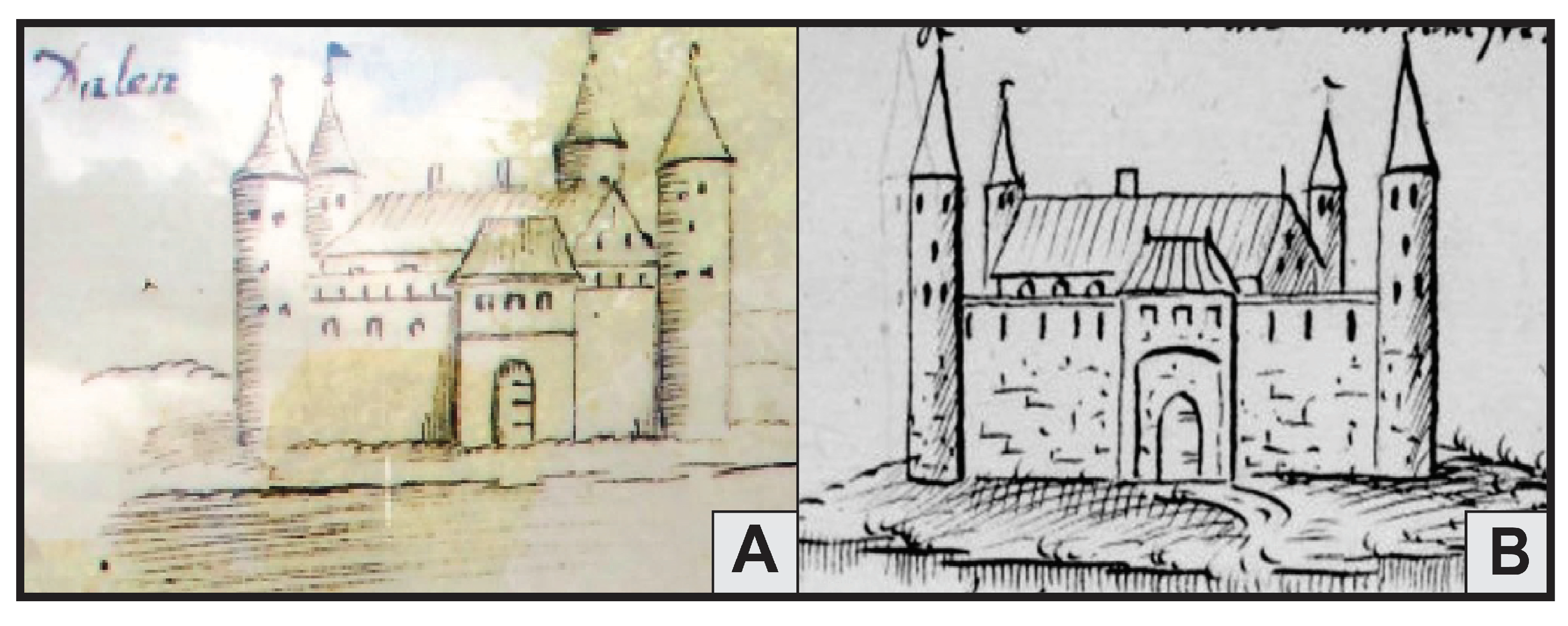
2.2.2. Iconographic Depictions Related to Jaundole Castle (1359 to 1628)

Two drawings of Jaundole Castle were created prior to its destruction or, in retrospect, after its destruction (Figure 4). Drawing A is credited to Johann Christoph Brotze (Broce) [20]. It was created between 1776, eight years after he arrived in Riga, and 1818, five years before he died. Brotze’s life work is contained in ten leather-bound volumes titled “Sammlung verschiedener Liefländischer Monumente, Prospect, Wapen, etc. 1776–1818” (Collection of various monuments, sights, coins, coats of arms, etc., 1776–1818) [20]. The drawing of Jaundole Castle as it looked in 1612 [16] is from this collection, part of which is housed at the Academic Library at the University of Latvia. Brotze was a teacher and collector known to collect various historical materials and draw everything that seemed significant to him, including people, buildings, coins, coats of arms, urban plans, and technical innovations [21]. Drawing B was created by Jürgen Helms as part of his “Livonian Chronicle”, which was compiled from 1628 to 1643 and destroyed in a fire at the Loddiger Pastorate in Riga in 1797. Several copies of the original still exist [22], and the Medieval Castles of Latvia website indicates that his drawing represents the castle in 1628, before its destruction [16].
Both castle drawings similarly depict the castle as essentially square in shape and possessing four towers, one at each corner of the square. Within each drawing, the towers are depicted as round, topped with a spire, and similar in circumference and height. The castle’s main gate is visible in both drawings.
A map that depicts the north portion of Dole Island can be found on the Castles of Latvia (Jaundole Castle) website [16]. It is the first image in the “old images” section of the image gallery along the right side of the screen. This map from 1627 shows the location of the castle and contains an inscription, that when tanslated reads “has been blown up, but the fortifications are still there”, indicating that the map was created, or modified, after 1628, when the retreating Poles destroyed the castle. Also, of note is that the Lebjava River transects the entire island, flowing from the Daugava River side (east) to the Dry Davgava River side of the island. Eventually, most likely because of the expansion of agricultural lands near Dole Island, geomorphic conditions associated with the rivers changed. Increased sediment loads in the Daugava River because of these land use changes caused the aggradation of the river channel, which increased sediment loads and deposition, which eventually cut off flow from the Daugava River into the Lebjava River.
Johann Christoph Brotze, in 1777 created a map that depicts Dole Island, which includes the location of Jaundole (Dahlen) Castle, as part of his ten volume set “Sammlung verschiedener Liefländischer Monumente, Prospect, Wapen, etc. 1776–1818” [20] (Figure 5). The Lebjava River is drawn on the map as not traversing the entire width of the island from the Daugava to the Dry Daugava River. Because the location of Jaundole (Dahlen) Castle is plotted on the map, the ruins of the castle were probably still visible on the land surface in 1777.

2.2.3. Historical Timeline and Related Events for Jaundole Castle (1628 to 1839) [16]

  • After its destruction in 1627, the castle was no longer used as a military fortification, and over the years, the ruins were eventually covered with earth and practically disappeared.
  • In 1631, the first manor estate, whose owner was a Swedish army officer, was established on Dole Island within two km of the Jaundole and Vecdole Castle sites.
  • After the Great Northern War, which ended in 1721, possession of the manor estate changed hands many times.
  • Already in the 18th century, almost nothing remained of the castle walls.
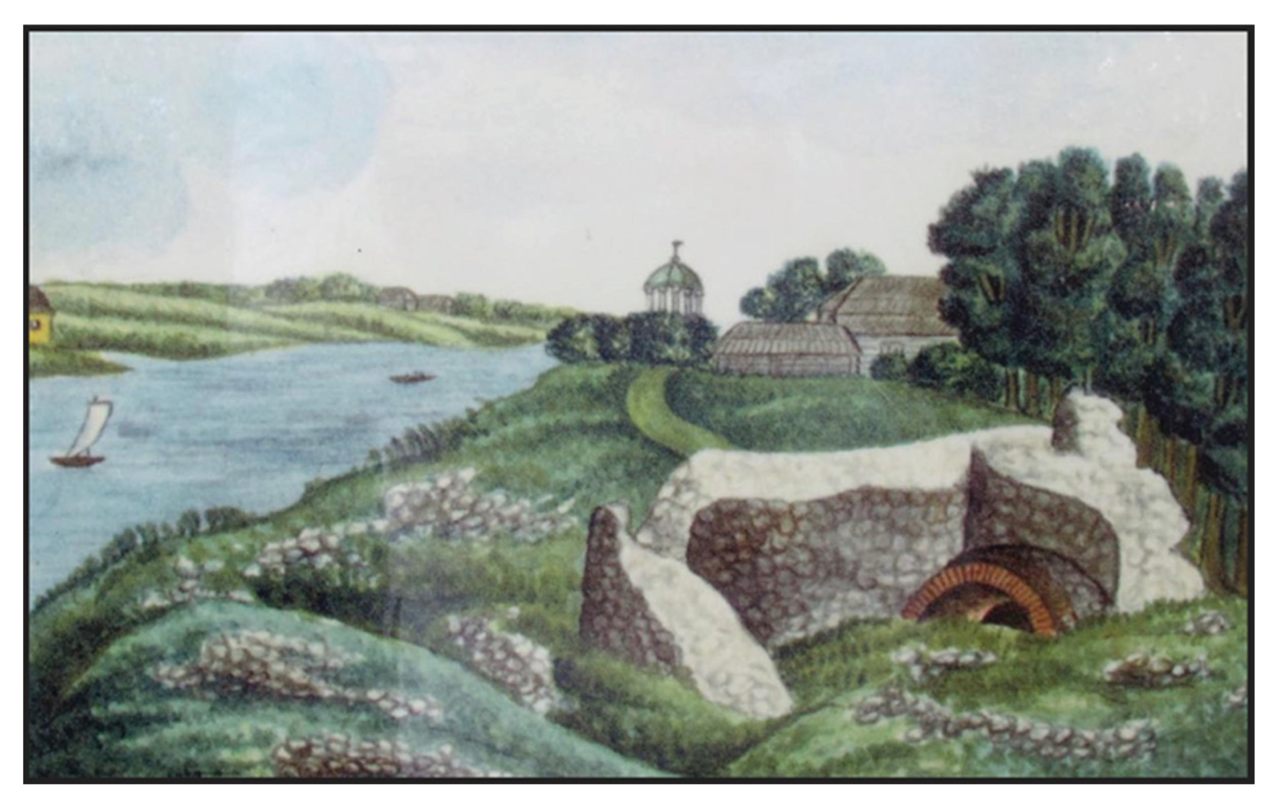
  • In the 19th century, as depicted in an 1830 painting, the remains of Jaundole Castle were still visible on the land surface (Figure 6).
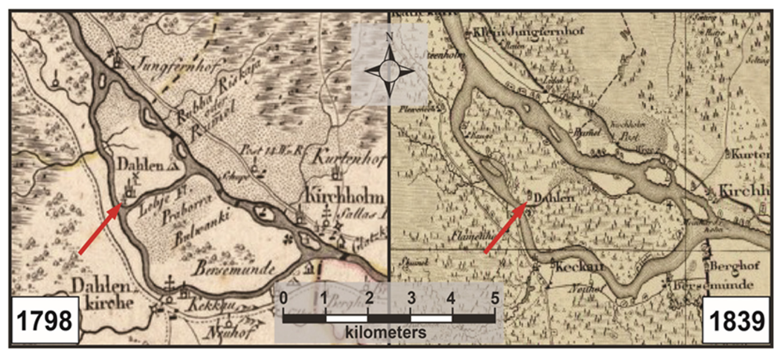
  • In 1839, the Livonian Charitable and Economic Society published a map of Dole Island (Figure 7).

2.2.4. Iconographic Depictions Related to Jaundole Castle (1628 to 1839)

The painting presented in Figure 6 depicts the west side of Dole Island in 1830, with the ruins of the Jaundole Castle visible in the foreground and buildings associated with the Dole Manor Estate in the background [17,18]. A. Merkela is noted as the artist, but no other information about the painting or the painter is provided. A thorough search for more information yielded no new results. The perspective of the painting looks to the northwest from just south of the castle ruins. The ruins and estate buildings are perched on high ground atop a dolomite bluff along the Dry Daugava River’s right side (east). Across the river, on the channel’s left (west) side, the land gently slopes down to the river and is covered by agricultural fields. As previously noted, the castle was moved from the east side of Dole Island, when it was called Vecdole, to the west side of the island, where it was called Jaundole because of the stability of the riverbank and the proximity to fertile, productive agricultural lands [16].
Maps from the mid-18th and 19th centuries depict the location of Jaundole (New Dahlen) Castle, which would have been in ruins (Figure 7). The map labeled 1798 in Figure 7 is from the map series Atlas von Liefland, oder von den Heyden Gouvernementern u. Herzogthümern Lief- und Ehstland, und der Provinz Oesel in 1798 (Atlas of Livonia, or of the two governorates and duchies of Livonia and Estonia, and the province of Oesel in 1798). This map series comprises a general map and fourteen district maps [23]. The map in Figure 7 is an excerpt from the Riga District map in this series. The series was created by cartographer Count Ludwig August Mellin [24] and published by noted Riga book trader and publisher Johann Friedrich Hartknoch [25]. The 1839 map, Specialcharte von Livland (Special Charter of Livonia), was published by the Livonian Charitable and Economic Society (Livländische Gemeinnützige und Ökonomische Sozietät), whose first Secretary, Georg Friedrich Parrot, was responsible for the creation and publication of the map [26].
The 1798 map indicates the presence of Jaundole (Dahlen) Castle, which was in ruins at this point after its destruction in 1628 (Figure 7). The Lebjava River still transected Dole Island, as it did in the 1627 map that can be found on the Castles of Latvia (Jaundole) website [16]. The castle ruins were also included on the 1839 Livonian Charitable and Economic Society map, but the Lebjava River no longer transects the island (Figure 7). Interestingly, the Johann Christoph Brotze map from 1777 indicates that the Lebjava River did not transect the island (see Figure 5). This discrepancy between the 1777 and 1798 maps is either a cartographic error, or indicates that the presence/absence of the Lebjava River was cyclical within this time frame.

2.2.5. Historical Timeline and Related Events for Jaundole Castle (1898 to 2024)

  • In 1898, a new manor house was constructed on a bluff above the Dry Daugava River near where it intersects with the by then defunct Lebajva River and, hence, near the former site of Jaundole Castle [17,18].
  • In 1957, Latvian archaeologist Andris Caune drew a plan of the remains of the walls of Jaundole Castle.
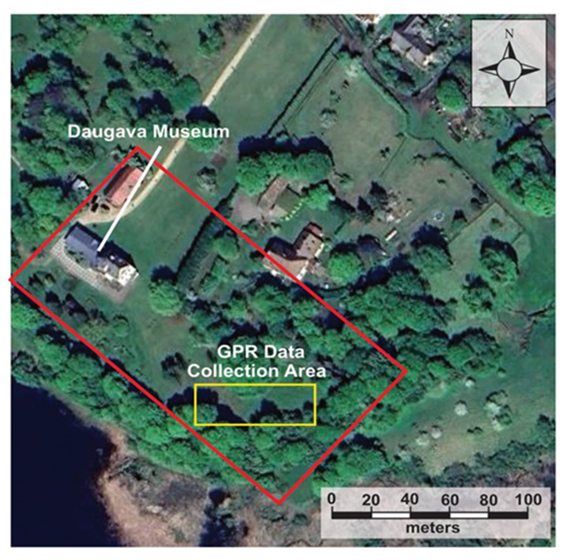
  • In 1977, the Daugava Museum, which is located in the 1898 Dole Manor House, opened to the public [18].
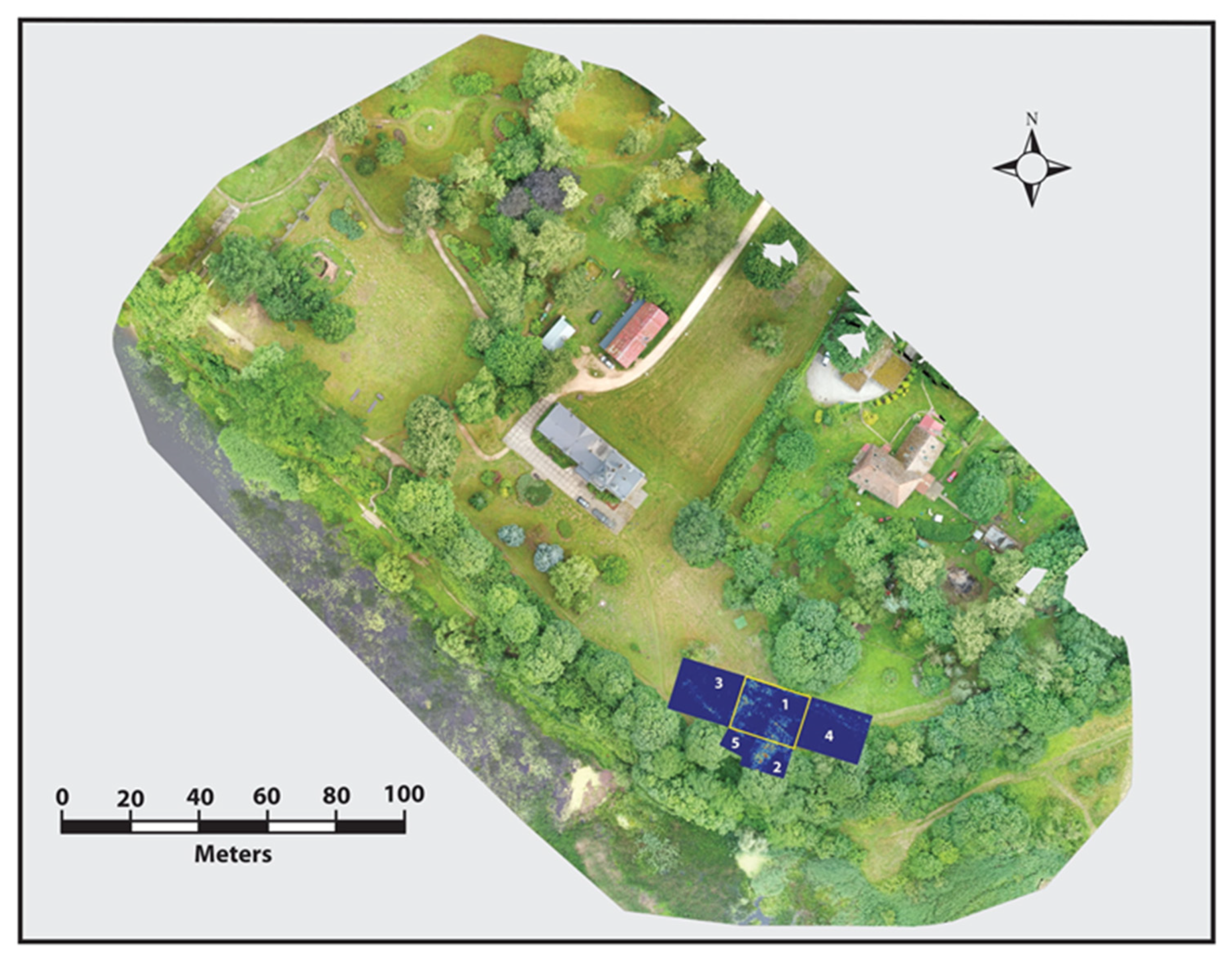
  • In 2024, a research team from Duquesne University and the University of Wisconsin-Eau Claire completed data collection using GPR to find the location of the buried remains of Jaundole Castle.

2.2.6. Historical Interpretations (1631 to 2024)

In 1631, Dole Manor Estate belonged to Colonel N. Sperreitern and later, to Count G. Gustavson. After the Great Northern War ended in 1721, Field Marshal P. de Lacy became the owner. Major General Baron von Boie then owned the manor, and around 1756, the manor was mortgaged to Baron O.H. von Fitinghoff, who sold it, and it eventually came into the possession of W. von Lévis of Menard, who had the neo-Romanesque-style manor house built in 1898. The Menard family owned the manor until 1921. At the beginning of the 20th century, it housed an elementary school, a fishermen’s collective farm club in Soviet times, and, since 1977, the Daugava Museum [17,18].
Andris Caune, an archaeologist from the Institute of the History of Latvia, which is affiliated with the University of Latvia, visited the Jaundole Castle site in 1957. Using his expertise in archaeological drafting, he completed a plan that depicted the remaining walls and placed them within the context of the former castle’s footprint [16]. In his plan, Caune referred to features he mapped as Dole Castle foundations. Caune mapped approximately 25 m of exposed foundation and a small section of perpendicular wall at the top of the 12 m high dolomite bluff along the Dry Daugava River at the mouth of the former Lebjava River (Figure 8). Based on Caune’s plan in 1957, approximately 20% of the castle foundation (walls) were still visible on the land surface at that time [16]. See Figures S12–S20 in the supplemental materials for additional maps, diagrams, and information related to the Jaundole Castle study site.

3. Materials and Methods

3.1. Methodological Background

Although complementary geophysical methods such as electromagnetic induction or resistivity tomography can provide valuable information, the present study focused on using GPR due to its availability, high resolution, and proven effectiveness in this type of archaeological research. In the study area, an approximately 20 × 60 m area on the bluff above the Dry Daugava/Lebjava River confluence was designated as the area of interest for locating the buried remains of Jaundole Castle (Figure 9). Permission to complete this non-invasive survey was obtained from the Daugava Museum’s director.
Five grids of varying sizes were established within the 20 × 60 m area to facilitate the collection of GPR data. Grid 1 was 20 × 16 m in size; grid 2 was 10 × 14 m; grid 3 was 20 × 16 m; grid 4 was 20 × 15 m; and grid 5 was 10 × 8 m. Figure 10 shows the location of the five GPR grids within the study area. In the results section, a composite of all five grids is presented. Further, specific interpretation of the GPR data in the results section is focused on GPR grid 1, which contains multiple data anomalies (reflections) at different depths below the land surface, which possess a distinct possibility of being related to the remains of Jaundole Castle.

3.2. GPR Methodology

The GPR technique used in this study is based on the propagation and reflection of pulsed high-frequency electromagnetic (EM) energy [27,28]. This field technique, which provides near-surface, high-resolution, near-continuous profiles for the investigation of shallow subsurface features, is used more frequently at archaeological sites because of the availability of portable, robust digital GPR systems [29,30,31]. Publications from past investigations by the researchers involved in this project and others have shown that GPR is a valuable, efficient, and practical research methodology [32,33,34,35,36,37,38,39]. The GPR acquisition system used for this project is a Sensors and Software pulseEKKO™ Pro [40]. GPR profiles were collected with 500 MHz antennae using a 100 ns time window, based on needs assessment discussions with local archaeologists. The antenna separation was 0.23 m, and to provide good horizontal resolution, the step size was 0.02 m, triggered by a wheeled odometer. A DVL carrier transport system was used to aid in data collection time so that the system could be easily pulled across the land surface (Figure 11). A minimum trace stacking of 4 was used during data collection, with a time sampling interval for each trace of 200. Within the grids, individual lines were collected 0.25 m apart and parallel to the previous line. The digital profiles were downloaded from the DVL using a USB drive, saved to an external hard drive, and processed with the Ekko Project v.6 software package [41]. Basic processing and visualization routines included dewow/signal saturation correction, envelope/migration, bandpass filtering, background subtraction, and a spreading exponential calibrated compensation (SEC) gain. The near-surface velocity of 0.10 m/ns was measured from the hyperbolic velocity calibration tool [40]. The profiles were geometrically corrected for topography using a Topcon self-leveling laser RL-H4C. The application of radar stratigraphic analysis (distinct signature patterns) on the collected data provided the framework to investigate lateral and vertical geometry and the stratification of archaeological features [42,43].

4. GPR Results and Data Interpretation

GPR reflection patterns in the data are concentrated in grid 1, although they extend somewhat into grids 2, 3, and 5 (Figure 12). Because the main concentration of reflection patterns is present in grid 1, this grid is discussed in detail. Data for GPR grid 1 are presented as time slices at four progressively deeper depths (0.60 to 0.65 m; 0.90 to 0.95 m; 1.80 to 1.85 m; and 1.90 to 1.95 m) below grid line 26 and in cross-section with the same four depths delineated. The software associated with the GPR data acquisition system [41] allows the data to be sliced in 10 cm intervals, wherein precise layers of data can be viewed at selected depths beneath the grid’s surface [44,45]. This software also displays the data in cross-section (looking from the side) for the same line within the GPR grid.
The mosaic of time slices presented in Figure 12 is from 1.45 to 1.50 m beneath the land surface. The location of the grids on the contemporary landscape is presented in Figure 10. The area covered by the five grids is approximately 1200 m2. Numerous linear reflective patterns are present within these time slices, with right-angle bends associated with some of the reflections. Geologic and geomorphic processes can create linear features in near-surface earth materials, but right-angle bends are often associated with anthropogenic activity [32,46,47].
The five grids in Figure 12 are oriented in a southeast-to-northwest direction. The white line on Figure 12 indicates where the edge of the grid abuts a wooded strip of land at the top of the bluff above the Dry Daugava River. It was not possible to collect GPR data at these locations because of the presence of trees and undergrowth. The break in the white lines between grids 5 and 2 is where a gap in the wooded strip leads to a path that goes down to the Dry Daugava River. The solid blue zones to the left of the white lines are areas where data were not collected because of the trees and undergrowth. The gray lines in Figure 12 outline areas where buried structural features exist based on the interpretation of the GPR time slice data. Letter A indicates locations where linear reflection patterns exist that were interpreted to be the remains of ruined castle walls. Letter B indicates an area where the reflection pattern was rounded, possibly indicating the location of one of the castle towers. Letter C indicates a possible interior room in the castle, and letter D is a yet-defined linear reflection pattern. The five time slices used to create the mosaic in Figure 12 are available in the supplemental materials still overlaid, but without any markup (Figure S21) and individually (Figures S22–S26). Figure 13 contains photographs of the GPR data collection process in the general area of the grids (Figure 13A), along the edge of the wooded area (B), and in the area where the path leads down to the river (C).
Figure 14 depicts GPR time slice data for grid 1 from 0.60 to 0.65 m below the surface. Grid 1 was 20 × 16 m in size and was placed in an open area between the narrow-wooded strip above the bluff and another wooded area to the east (see Figure 10). A prominent linear reflection pattern is bracketed by the dashed orange line marked on this time slice. This reflection pattern, which is interpreted to be the remains of a significant structural feature (possibly a wall), extends for approximately 7 m before making a 90-degree bend and then extending for an additional 11 m.
At this depth, two other distinctive reflection patterns are present on the time slice along GPR grid line 26, which is located 6.5 m from the zero point along the x-axis of the grid (Figure 14). These reflection patterns are delineated by red and yellow boxes, with the yellow box interpreted to be a section of a wall, and the red box an isolated structural feature like the base of a column or a rubble layer. An additional reflection pattern not located along grid line 26 is delineated by the light blue box in Figure 14, which is also interpreted to be the base of a column or a rubble layer.
The reflection patterns that are crossed by GPR line 26 are delineated in the cross-section (Figure 15) for the 0.60 to 0.65 m time slice, as well as the time slices for the three other depths. As discussed below, the cross-section contains hyperbolas and disrupted layers that coincide with reflection patterns contained in the four time slices. Hyperbolas are inverted U- or V-shaped reflection patterns created when the radar wave bounces off point objects buried beneath the land surface [48,49]. In the context of this research, these point objects, in our opinion, are the remains of buried walls or rubble from the destruction of the castle.
In Figure 15, the red box at a depth of 0.6 to 0.65 m coincides with the location of the red box in the time slice (Figure 14). The hyperbola within the red box marks, in our opinion, the location of buried rubble associated with the castle’s destruction. It may also represent a single object, like a boulder, associated with the destruction. The yellow box in the time slice delineates a section of castle wall that is indicated in the cross-section by the yellow line that originates at this depth and extends through the other time slice depths to the maximum depth of GPR signal penetration (approximately 2.0 m). Based solely on the GPR time slice and cross-section data, it is not possible to determine the specific characteristics of the buried feature in terms of whether it is intact, partially intact, or rubble. The interpretation of the GPR data indicates that this area is anomalous compared to surrounding areas, but only archaeological excavation will reveal the true nature of the buried object(s). Additionally, time slices without any markup for the depths 0.6 to 0.65 m, 0.9 to 0.95 m, 1.80 to 1.85 m, and 1.90 to 1.95 m, and accompanying cross sections from GPR data line zero, are available in the supplemental materials in Figures S27–S30.
Figure 16 presents time slice data for GPR grid 1 from 0.90 to 0.95 m below the surface. The linear reflection pattern, again bracketed by orange dashed lines similar to Figure 14, is again interpreted to be the remains of a wall, which, at this depth, is not as distinct as the same feature at 0.60 to 0.65 m below the surface. This is especially true in the section after the right-angle bend, which likely indicates that the reflection pattern present in Figure 14 does not extend to or is less defined at this depth. The remains of the wall within the yellow box in Figure 14 are even more distinct at this depth in Figure 16. The fact that this feature extends to this depth justifies the extension of the yellow line in the cross-section from 0.60 to 0.95 m below the surface (see Figure 15).
Figure 17 is a GPR time slice from a depth of 1.80 to 1.85 m below the surface. The reflection pattern interpreted as the remains of a wall bracketed by the orange dashed lines in Figure 14 and Figure 16 is still present at this depth, as indicated by the same yellow box in Figure 17. The fact that this feature is still present at 1.80 m below the surface justifies further extension of the yellow line from 0.95 to 1.85 m below the surface in the cross-section (Figure 15). Some semblance of the right-angle bend in Figure 14 and Figure 16 is still present at this depth, as indicated by the dashed orange line in Figure 17. Adjacent to the orange dashed line, between that line and the yellow box, is a circular reflection pattern that may indicate the location of rubble or structural elements associated with one of the castle’s towers. At this depth in the time slice, four other distinct reflection patterns are present and are indicated by the red, brown, blue, and white boxes in Figure 17. The reflection pattern in the blue box is located along grid line 26 and is, therefore, also visible in the cross-section in Figure 15. The reflection patterns in the white and brown boxes are not found along GPR line 26 and are, therefore, not part of the cross-section. The reflection patterns in the white and brown boxes are visually similar to each other and are interpreted to be either concentrations of rubble or the base of a structural feature associated with the castle. The reflection pattern within the red box is equally distinct but is more linear and is interpreted to be rubble or a structural element (like a wall).
Figure 18 is time slice data from a depth of 1.90 to 1.95 m beneath the surface. Although these data are only 5 cm deeper than the data presented in Figure 17, the reflection patterns are somewhat different. Contrasting Figure 17 and Figure 18, the pattern within the red box is less defined in Figure 18. The reflection pattern within the brown square is more compact and slightly less defined, and the reflection patterns in the blue and white boxes in Figure 17 have coalesced into what is interpreted as a single feature in Figure 18, as marked by the white box. Because grid line 26 partially passes through the white box in Figure 18, it is included in the cross-section as a white box that surrounds the blue box that represents the data anomaly from 1.80 to 1.85 m. The reflection pattern associated with the yellow box that is present in all four time slices justifies extending the yellow line in Figure 15 down to a depth of 1.95 m.
The time slice data from GPR grid line 26 varies with depth, and the changes over the 5 cm distance between 1.85 and 1.90 m can be interpreted in two ways. The reflection patterns are less distinct at this depth because these data are from a zone approaching the base of the structural features, or the GPR signal at this depth is being attenuated and is not returning a strong signal to the receiver within the GPR system.

5. Discussion

Using GPR time slice and cross-section analysis as part of archaeological studies has successfully mapped structural features in the subsurface [50]. Archaeological prospection and excavation share similar objectives in that they both seek to study the material culture of humans. Archaeological excavation can be guided by non-invasive technology, like GPR, to determine locations where the highest probability exists to uncover artifacts and structural remains. The interpretation of GPR data allows preliminary assessments to be completed that involve identifying, classifying, and determining spatial relationships within the collected data. Accurate archaeological models can be developed based on these interpretations, which can be used to target excavations [51].
The GPR data collected in 2024 was intended to be an initial step, along with gathering historical data and iconographic materials, in developing a preliminary plan to place several archaeological excavation test pits at locations where GPR indicated a high probability of encountering buried remains associated with Jaundole Castle. Archaeological materials discovered within the proposed test pits can then serve as the impetus for additional geophysical investigations, followed by eventual full-scale archaeological excavation.
The compilation of historical and iconographic information confirmed that Jaundole Castle, which was destroyed in 1628 by the Poles, who occupied the castle from 1626 to 1628 during the fourth stage of the Polish–Swedish War [52], once stood at the confluence of the Lebjava and Dry Daugava Rivers. The interpretation of GPR time slice data and related cross-sections confirmed that distinct linear and, in some cases, circular reflection patterns exist at this location, which, in our opinion, correlate with ruined walls or piles of rubble associated with parts of the castle [31,53]. Additionally, based on the location, size, and shape of reflection patterns found in the GPR data, some of these patterns may be associated with the main gate into the castle (see Figure 4). However, additional GPR data collection in concert with archaeological excavation is required to further explore this and other archaeological possibilities.
The data generated via the multidisciplinary research approaches utilized for this project added new information to the existing knowledge base about the history of Dole Island and the Vecdole and Jaundole Castles. Additionally, data compiled using GPR indicated locations where buried structural elements of Jaundole Castle exist on the property of the Daugava Museum. Through the combined approach of melding historical and iconographic information with scientific data generated using GPR, the hidden history of Jaundole Castle is being uncovered [54].

6. Summary and Conclusions

Three overarching research objectives were posed for this research. They are restated below, and specific conclusions for each objective are listed.
(1)
Identify the likely location, layout, and function of Jaundole Castle through historical sources.
  • Two drawings of Jaundole Castle were found that indicate that the castle’s shape was square, with towers at each corner topped by a spire.
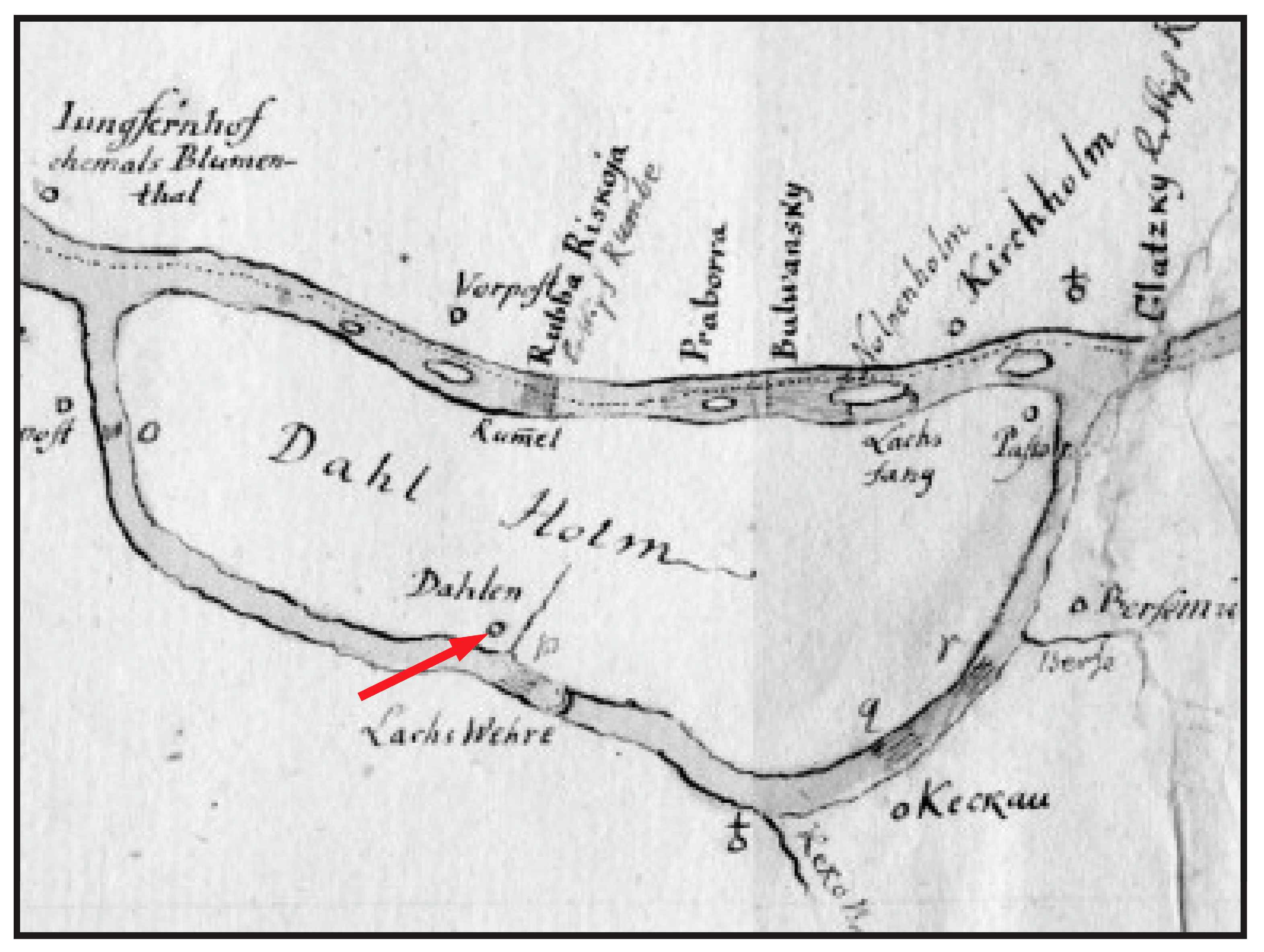
  • A 1627 map exists on the Castles of Latvia (Jaundole Castle) website [16] that depicts the northern portion of Dole (Dahlen) Island and shows that Jaundole Castle was located at the confluence of the Lebjava and Dry Daugava Rivers. This map contains the inscription “has been blown up, but the fortifications are still there”, indicating that it was destroyed in 1627 or before.
  • In a painting by A. Merkela from 1830 (see Figure 6), the ruins of Jaundole Castle can still be seen, with fertile farmland, associated with the main economic function of the castle, depicted across the Dry Daugava River.
  • A small area containing the ruins of the castle could still be seen on the land surface in 1957.
(2)
Evaluate the effectiveness of ground-penetrating radar (GPR) for detecting its buried remains.
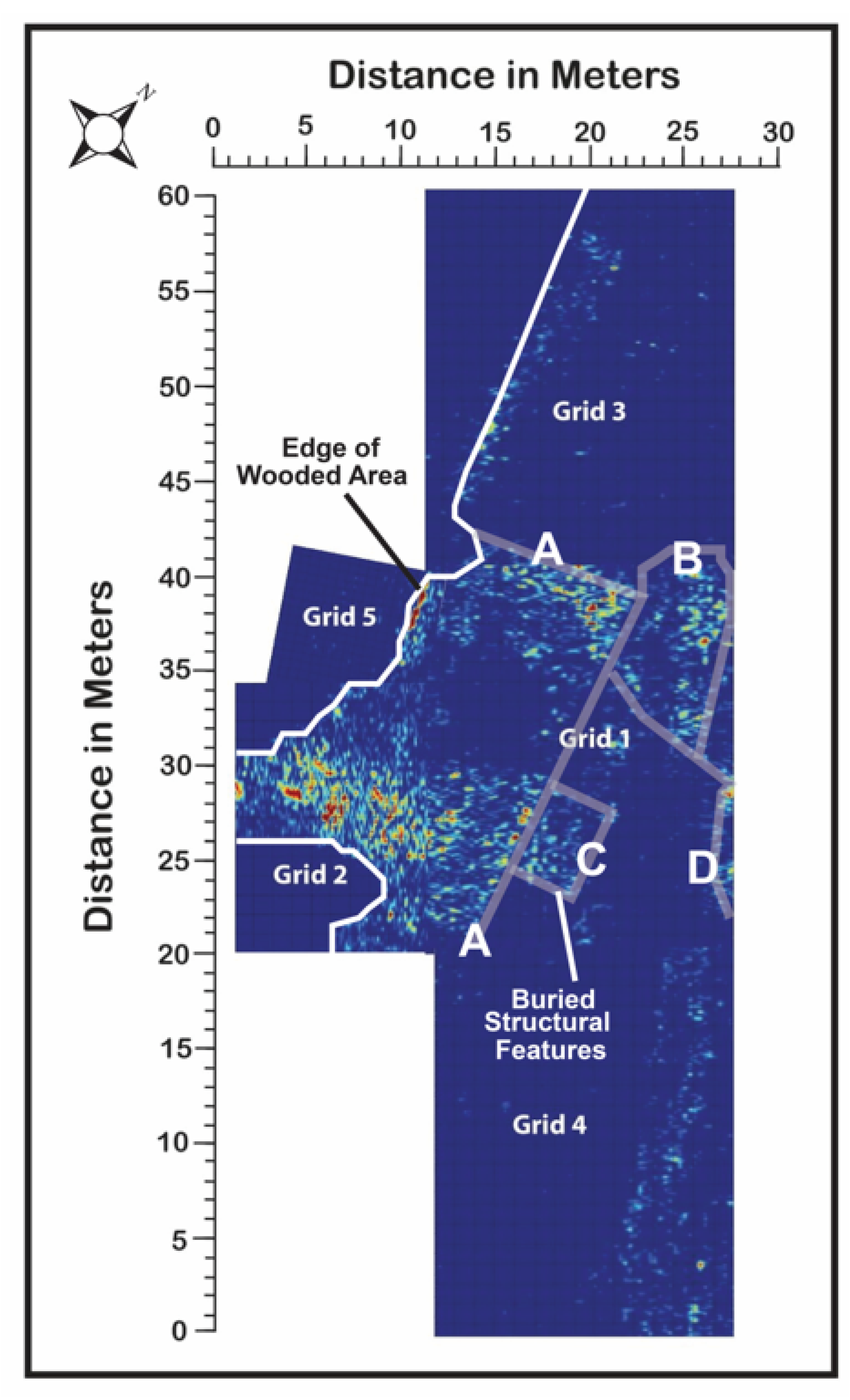
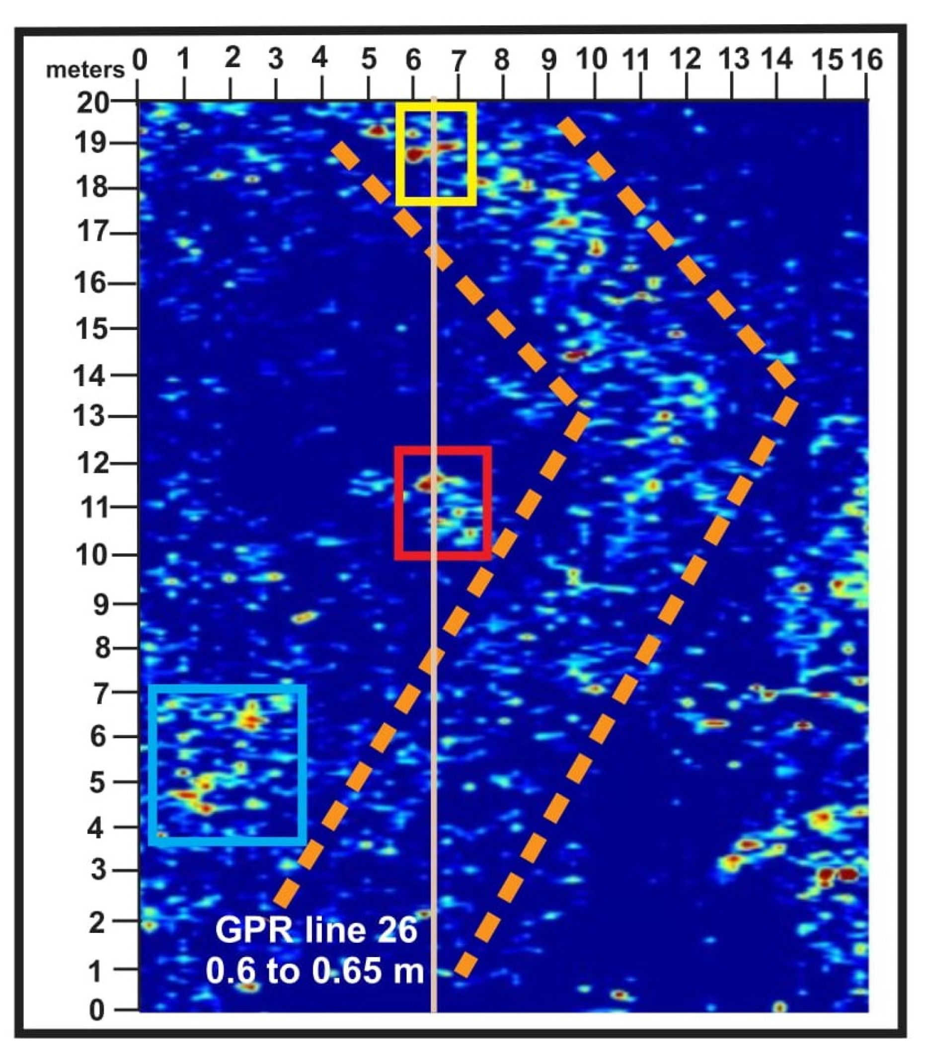
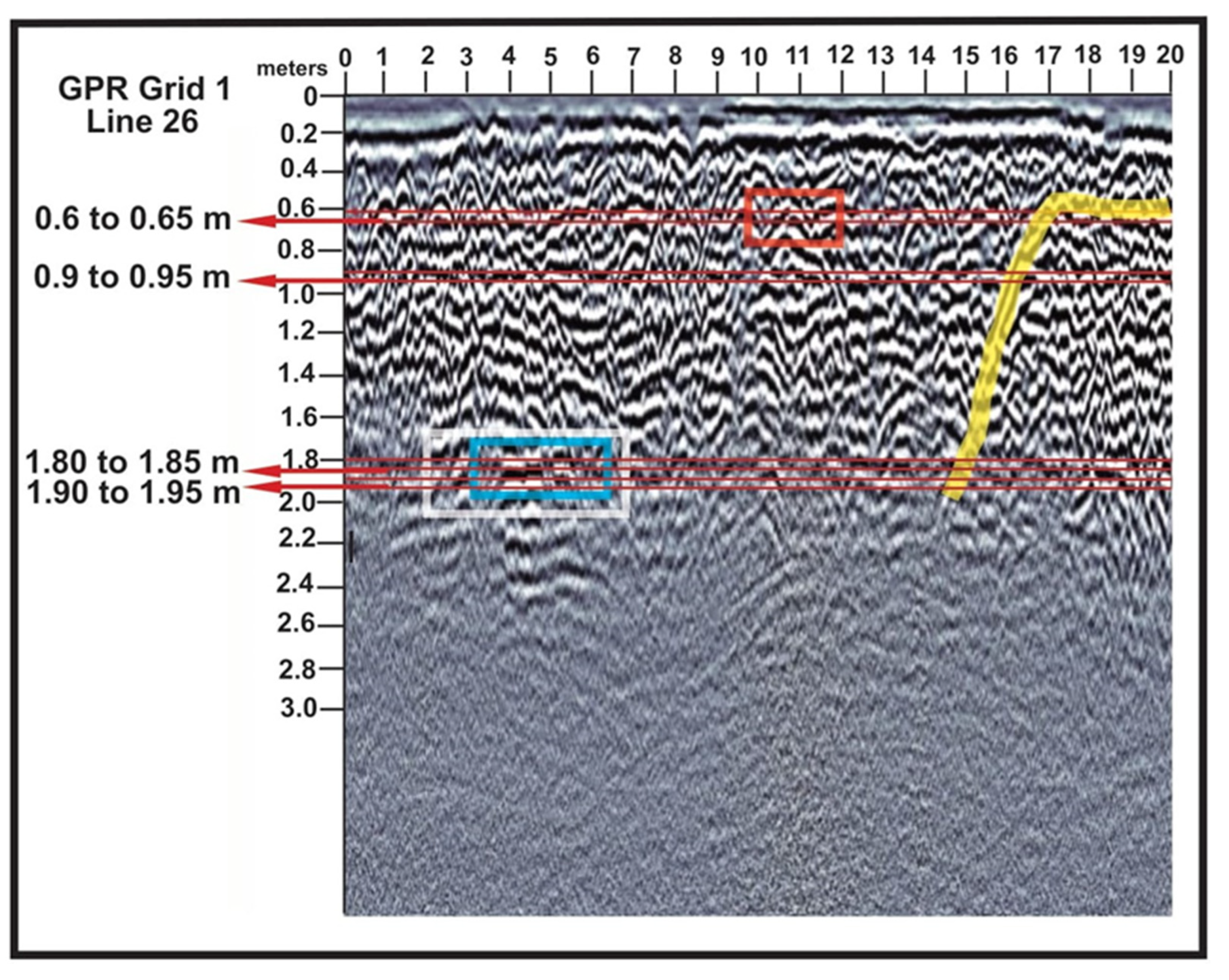
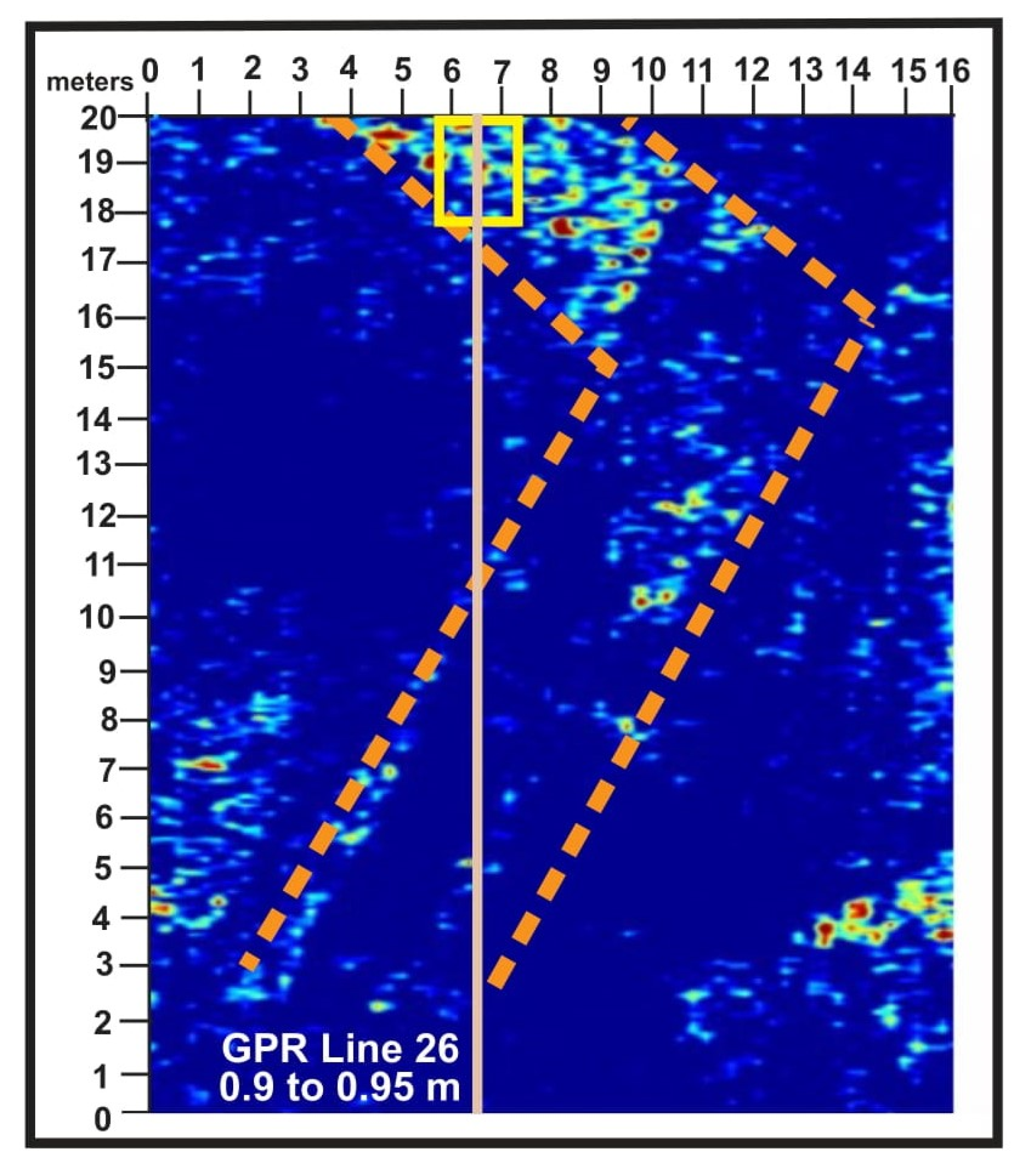
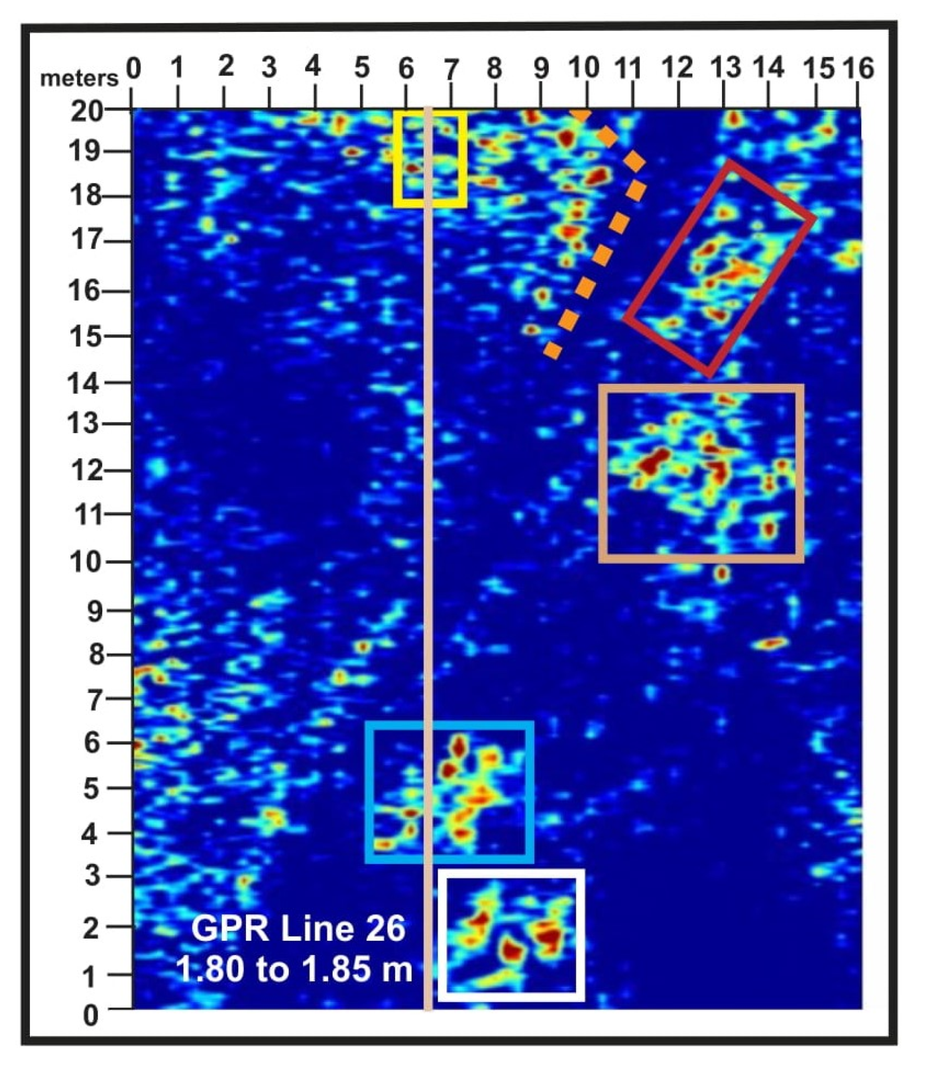
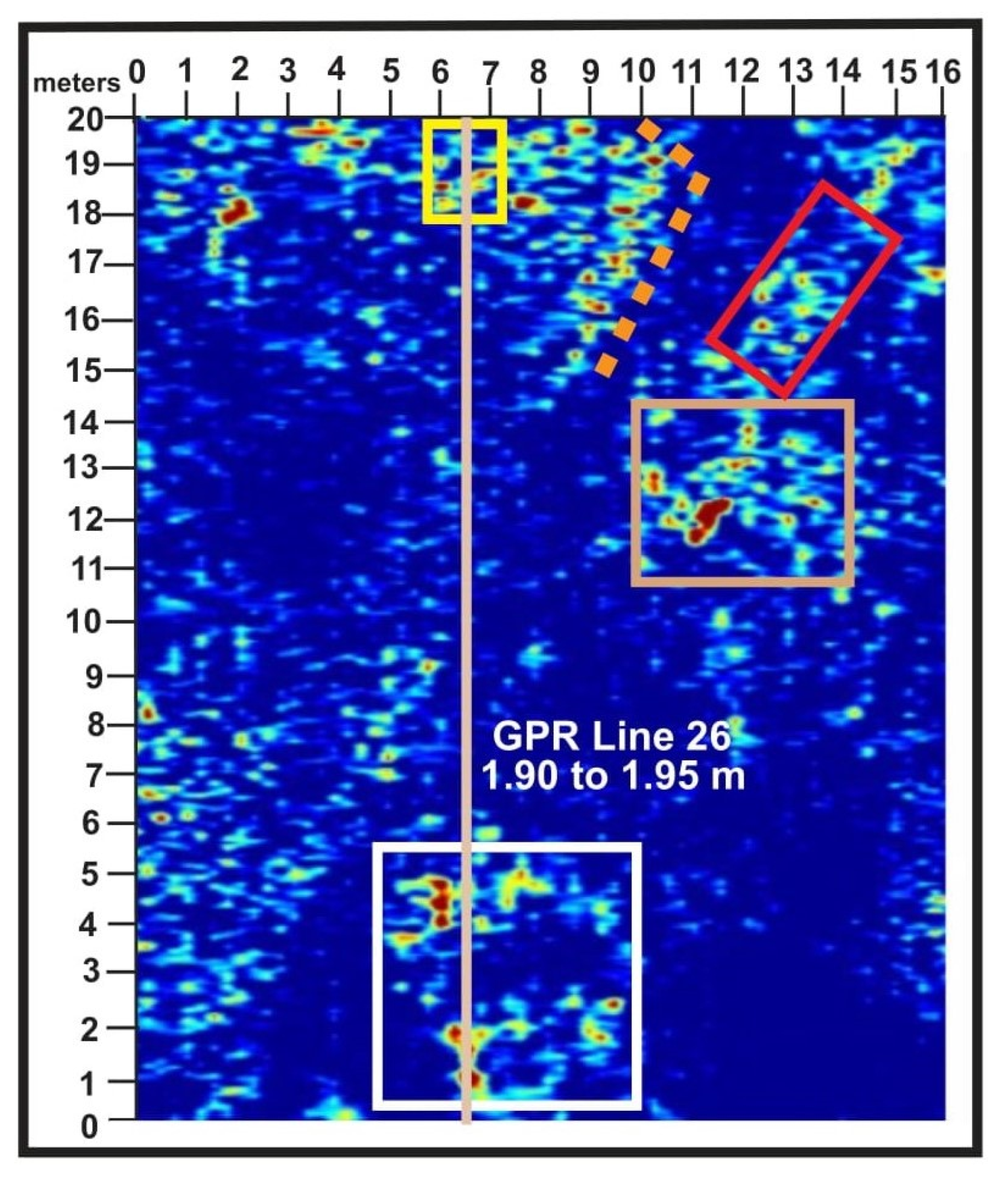
  • GPR detected numerous reflection patterns in the subsurface within the five grids (see Figure 12), with the greatest concentration in grid 1.
  • On average, the penetration depth in the five grids analyzed in 2024 was 2.5 m, with structural features related to the castle that are buried beneath the contemporary landscape detectable down to depths of at least 2 m.
(3)
Determine whether structural elements can be interpreted from GPR data to support future archaeological excavations.
  • The reflection patterns present within the GPR grids, with grid 1 containing the most reflections, are linear, probably indicating buried Jaundole Castle wall locations, and, to varying degrees, circular, indicating rubble piles or other human-constructed features.
  • Based on these discoveries, possible test excavation locations were provided to the director of the Daugava Museum and the stewards of the property, and it is probable that test excavations will verify that the GPR data reflection patterns and associated features in the cross-sections are associated with the remains of Jaundole Castle.
  • In that case, additional GPR data will be collected to assist with the development of full-scale excavation targets, but no timeline has yet been developed for these excavations.

Supplementary Materials

The following supporting information can be downloaded at: https://www.mdpi.com/article/10.3390/heritage8050161/s1, Figure S1: Base satellite image from https://vesture.dodies.lv/: National Archives of Latvia; Figure S2: Closer view of Dole Island with study area location indicated; Figure S3: Google Earth image of the study area where the five GPR grids were placed; Figure S4: Composite figure containing maps and images; Figure S5: Drone image of the study area with no markup; Figure S6: 1866 map from https://vesture.dodies.lv/: (27 April 2025). National Archives of Latvia); Figure S7: 1884 map from https://vesture.dodies.lv/: (27 April 2025). National Archives of Latvia); Figure S8: 1920 map from https://vesture.dodies.lv/: (27 April 2025). National Archives of Latvia); Figure S9: 1942 map from https://vesture.dodies.lv/: (27 April 2025). National Archives of Latvia); Figure S10: 1963 map from https://vesture.dodies.lv/: (27 April 2025). National Archives of Latvia); Figure S11: 1986 map from https://vesture.dodies.lv/: (27 April 2025). National Archives of Latvia); Figure S12: Andris Caune map of Jaundole ruins in 1957 from an interpretive sign at the Daugava Museum; Figure S13: Translation from interpretive sign at the Daugava Museum; Figure S14: Information provided by the University of Latvia about archaeologist Andris Caune; Figure S15: Translation from interpretive sign at the Daugava Museum; Figure S16: Translation from interpretive sign at the Daugava Museum; Figure S17: Translation from interpretive sign at the Daugava Museum; Figure S18: Translation from interpretive sign at the Daugava Museum; Figure S19: Area map with an image of Jaundole Castle from an interpretive sign at the Daugava Museum; Figure S20: Close up of an area map with an image of Jaundole Castle from an interpretive sign at the Daugava Museum; Figure S21: Castle time slice mosaic without data markup (Figure 12 in article); Figure S22: GPR grid1 at 1.45 m below the surface; Figure S23: GPR grid 2 at 1.45 m below the surface; Figure S24: GPR grid 3 at 1.45 m below the surface; Figure S25: GPR grid 4 at 1.45 m below the surface; Figure S26: GPR grid 5 at 1.45 m below the surface; Figure S27: Data at 0.65 to 0.70 m at GPR Line 0; Figure S28: Data from 0.90 to 0.95 m at GPR Line 0; Figure S29: Data from 1.80 to 1.85 m at GPR Line 0; Figure S30: Data from 1.90 to 1.95 m at GPR Line 0.

Author Contributions

Conceptualization, P.R. and H.J.; methodology, P.R. and H.J.; software, H.J.; validation, P.R. and H.J.; formal analysis, P.R. and H.J.; investigation, P.R. and H.J.; resources, P.R. and H.J.; data curation, P.R. and H.J.; writing—original draft preparation, P.R.; writing—review and editing, P.R. and H.J.; visualization, P.R. and H.J.; supervision, P.R. and H.J.; project administration, P.R. and H.J.; funding acquisition, P.R. and H.J. All authors have read and agreed to the published version of the manuscript.

Funding

This research was funded by a grant from the School of Science and Engineering at Duquesne University and the International Fellows Program, L.E. Phillips Family Foundation, Jeff Liddicoat, Office of Research and Sponsored Program—Student/Faculty Collaboration/Summer Research Experience for Undergraduate Grants from the University of Wisconsin-Eau Claire.

Informed Consent Statement

Not Applicable.

Data Availability Statement

The data sets used in this research are available upon request from the corresponding author. P.R. can be contacted at the following email address: reederp@duq.edu.

Acknowledgments

The research team consisted of Harry Jol (co-project director) from the Department of Geography and Anthropology at the University of Wisconsin (UWEC) and Martin Goettl, a Geospatial Technology Facilitator from UWEC. The following undergraduate students from UWEC were also members of the research team: Dana Anderson, Faith Fogarty, Ellen Heunisch, Jaden Olski, Tylor Rocha, and Reed Ziemer. Philip Reeder (co-project director) from the Department of Environmental and Energy Engineering at Duquesne University and Joseph Reeder, an undergraduate student in that program, were also members of the research team.

Conflicts of Interest

The authors declare no conflicts of interest.

References

  1. Medieval Castles of Latvia. Castles of Riga’s Bishop and Capital of Dome. 2025. Available online: https://www.castle.lv/castles4/episkop-eng.html (accessed on 3 March 2025).
  2. Medieval Castles of Latvia. Information About Castles of Different Countries, History, Architecture of Different Eras, etc. 2025. Available online: https://www.castle.lv/lv-title.html (accessed on 3 March 2025).
  3. Lettus, H. The Chronicle of Henry of Livonia, Trans. with New Introduction; Brundage, J.A., Ed.; Columbia University Press: New York, NY, USA, 2003; p. 262. [Google Scholar]
  4. Livonas.net. The Livonians in Ancient Times. UL Livonian Institute. 2025. Available online: http://www.livones.net/en/vesture/the-livonians-in-ancient-times (accessed on 2 March 2025).
  5. Mihm, R. The Livonia Crusade Told Through Henry of Livonia’s Chronical. 2024. Available online: https://storymaps.arcgis.com/stories/0856849a87214481b8e7976f552dc399 (accessed on 18 February 2025).
  6. Membership of the Teutonic Order. The Order of the Teutonic Knights of St. Mary’s Hospital in Jerusalem–1190. 2025. Available online: https://www.imperialteutonicorder.com/id62.html (accessed on 1 March 2025).
  7. Arnold, U. Eight Hundred Years of the Teutonic Order. In The Military Orders Volume I, 1st ed.; Barber, M., Ed.; Routledge: London, UK, 1994; p. 432. [Google Scholar] [CrossRef]
  8. The Postgrad Chronicles. European Medieval History from the Viking Age to the Hundred Years’ War. Crusaders on the Baltic Shore–The Livonian & Estonian Crusades (c. 1198–1290). 2025. Available online: https://thepostgradchronicles.org/2017/08/03/crusaders-on-the-baltic-shore-the-livonian-estonian-crusades-c-1198-1290/ (accessed on 2 March 2025).
  9. Sandomirskii, G.V. Construction of the Riga hydroelectric station. Hydrotech. Constr. 1974, 8, 594–599. [Google Scholar] [CrossRef]
  10. Vitalija, Z.; Markots, A. Deglaciation History of Latvia; Developments in Quaternary Science: Riga, Latvia, 2004; Volume 2, pp. 225–243. [Google Scholar] [CrossRef]
  11. Vasks, A. The Lower Reaches of the Daugava River in the Bronze Age, and the Earliest Iron Age (1800–500 to the 1st Century BC). Archaeol. Balt. 2021, 28, 132–148. [Google Scholar] [CrossRef]
  12. Svabe, A. The Story of Latvia—A Historical Survey; Latvian National Foundation: Stockholm, Sweden, 1949; Available online: https://latvians.com/index.php?en/CFBH/TheStoryOfLatvia/SoLatvia-01-chap.ssi (accessed on 4 March 2025).
  13. Brundage, J. The Thirteenth-Century Livonian Crusade: Henricus de Lettus and the First Legatine Mission of Bishop William of Modena. Jahrbücher Für Gesch. Osteur. 1972, 20, 1–9. [Google Scholar]
  14. Gummarssone, A.; Oras, E.; Talbot, H.; Ilves, K.; Legzdins, D. Cooking for the Living, and the Dead: Lipid analyses of Rauši Settlement and Cemetery Pottery from the 11th-12th Century. Est. J. Archaeol. 2020, 24, 45–69. [Google Scholar] [CrossRef]
  15. Medieval Castles of Latvia. Dole or Vecdole Castle (Alt-Dahlen). 2025. Available online: https://www.castle.lv/latvija/vecdole.html (accessed on 2 March 2025).
  16. Medieval Castles of Latvia. Dole or Jaundole Castle (Dahlen). 2025. Available online: https://www.castle.lv/latvija/jaundole.html (accessed on 4 March 2025).
  17. Zarāns, A. Latvijas pilis un muižas. In Castles and Manors of Latvia; Zarāns, A., Ed.; Latvia, 2006; p. 319. [Google Scholar]
  18. Daugava Museum. 2025. Available online: https://www.daugavasmuzejs.lv/en/par-muzeju-en (accessed on 5 March 2025).
  19. Sterns, I. Latvijas vēsture 1290-1500; Daugava: Riga, Latvia, 1997; p. 740. [Google Scholar]
  20. University of Latvia. Collection of Johann Christoph Brotze, Johana Kristofa Broces kolekcija/Collection of Johann Christoph Brotze. Sammlung Verschiedener Liefländischer Monumente, Prospect, Wapen, etc. 1776–1818; University of Latvia Academic Library: Riga, Latvia, 2025. [Google Scholar]
  21. Taimina, A. 500 Years of Latvian Books: Johann Christoph Brotze and His Meticulous Book Collection. LSM+. 2024. Available online: https://eng.lsm.lv/article/culture/literature/18.06.2024-500-years-of-latvian-books-johann-christoph-brotze-and-his-meticulous-book-collection.a558447/ (accessed on 10 March 2025).
  22. Helms, J. Alvin: Platform for Digital Collections and Digitized Cultural Heritage. Appendix. 2025. Available online: https://www.alvin-portal.org/alvin/attachment/document/alvin-record:12516/ATTACHMENT-0001.pdf (accessed on 11 March 2025).
  23. Library of Congress, Atlas of Liefland. 2025. Available online: https://www.loc.gov/item/75572471/ (accessed on 14 March 2025).
  24. Jürjo, I. Ludwig August krahv Mellin kui talurahva sõber ja estofiil. Dokument Ja Kommentaar. Tuna 2003. Available online: https://www.ra.ee/wp-content/uploads/2017/03/JyrjoIndrek_Ludwig_August_TUNA2003_4-1.pdf (accessed on 14 March 2025).
  25. Taimina, A. 500 Years of Latvian Books: The Hartknochs, Father-and-Son Enlightenment Publishers, LSM+. 2024. Available online: https://eng.lsm.lv/article/culture/literature/09.06.2024-500-years-of-latvian-books-the-hartknochs-father-and-son-enlightenment-publishers.a556570/ (accessed on 14 March 2025).
  26. Jeske, M. The map Specialcharte von Livland: Georg Friedrich Parrot’s agenda or a new perspective on Livland. Acta Balt. Hist. Et Philos. Sci. 2018, 6, 127–137. [Google Scholar] [CrossRef]
  27. Lombardi, F.; Podd, F.; Solla, M. From Its Core to the Niche: Insights from GPR Applications. Remote Sens. 2022, 14, 3033. [Google Scholar] [CrossRef]
  28. Luo, T.; Lai, W.; Chang, R.; Goodman, D. GPR imaging criteria. J. Appl. Geophys. 2019, 165, 37–48. [Google Scholar] [CrossRef]
  29. Conyers, L. Analysis, and interpretation of GPR datasets for integrated archaeological mapping. Near Surf. Geophys. 2015, 13, 645–651. [Google Scholar] [CrossRef]
  30. Zhao, W.; Forte, E.; Pipan, M.; Tian, G. Ground Penetrating Radar (GPR) attribute analysis for archaeological prospection. J. Appl. Geophys. 2013, 97, 107–117. [Google Scholar] [CrossRef]
  31. Manataki, M.; Vafidis, A.; Sarris, A. GPR Data Interpretation Approaches in Archaeological Prospection. Appl. Sci. 2021, 11, 7531. [Google Scholar] [CrossRef]
  32. Jol, H.; Bristow, C. An Introduction to Ground Penetrating Radar (GPR) in Sediments; Geological Society: Special Publications, London, 2003; Volume 211, p. 1. [Google Scholar] [CrossRef]
  33. Jol, C.; Jol, H.; Dettinger, M.; Singleton, K.; Freund, R.; Reeder, P.; Miazga, C.; Bauman, P.; Wiley, P.; Lensky, I.; et al. Subsurface Imaging of a Holocaust Mass Burial Site: Jungfernhof Concentration Camp, Riga, Latvia. In Proceedings of the 19th International Conference on Ground Penetrating Radar, Golden, CO, USA, 12–17 June 2022. [Google Scholar]
  34. Jol, H.M. Ground penetrating radar antennae frequencies and transmitter powers compared for penetration depth, resolution, and reflection continuity. Geophys. Prospecting. 1995, 43, 693–709. [Google Scholar] [CrossRef]
  35. Ground Penetrating Radar (GPR) Theory and Applications; Jol, H.M., Ed.; Elsevier: Amsterdam, The Netherlands, 2009; 524p. [Google Scholar] [CrossRef]
  36. Fischer, A.; Jol, H.; Uchyti1, G.; Hall, N.; Freund, R.; Bauman, P.; McClymont, A.; Miazga, C.; Reeder, P.; Konik, J.; et al. Searching for The Ringleblum Archives: Documentation of Life During the Holocaust-A Ground Penetrating Radar Investigation of Krasinskich Park, Warsaw, Poland. In Proceedings of the 19th International Conference on Ground Penetrating Radar, Golden CO, USA, 12–17 June 2022. [Google Scholar]
  37. Hall, N.; Jol, H.; Fischer, A.; Uchytil1, G.; Freund, R.; Bauman, P.; McClymont, A.; Miazga, C.; Reeder, P.; Konik, J.; et al. Holocaust Archaeology: GPR Subsurface Imaging of the Mila 18 Memorial in Warsaw, Poland. In Proceedings of the 19th International Conference on Ground Penetrating Radar, Golden, CO, USA, 12–17 June 2022. [Google Scholar] [CrossRef]
  38. Uchytil, G.; Jol, H.; Fischer, A.; Hall, N.; Freund, R.; Bauman, P.; McClymont, A.; Miazga, C.; Reeder, P.; Konik, J.; et al. Archaeological GPR investigation of the Bersohn and Bauman Jewish Children’s Hospital in Warsaw, Poland: Locating potential Holocaust artifacts. In Proceedings of the 19th International Conference on Ground Penetrating Radar, Golden, CO, USA, 12–17 June 2022. [Google Scholar] [CrossRef]
  39. Smith, D.; Jol, H.M. Ground penetrating radar: Antenna frequencies and maximum probable depths of penetration in Quaternary sediments. J. Appl. Geophysics. 1995, 33, 93–100. [Google Scholar] [CrossRef]
  40. Sensors and Software, Ground Penetrating Radar (GPR) Solutions. 2025. Available online: https://www.sensoft.ca/ (accessed on 14 January 2025).
  41. EKKO_Project™ GPR Software; Sensors and Software: Mississauga, ON, Canada, 2025. Available online: https://www.sensoft.ca/products/ekko-project/overview/ (accessed on 1 February 2025).
  42. Economou, N.; Bano, M.; Ortega-Ramirez, J. Delineation of Fractures Using a 2D GPR Processing Strategy for 3D Imaging: Weak Zones within Carbonates at the Archaeological Site of Xochicalco in Mexico. Appl. Sci. 2021, 11, 5893. [Google Scholar] [CrossRef]
  43. Lanzarone, P.; Bigman, D. Processing considerations and improved interpretation for ground-penetrating radar imaging of a relict archaeological excavation unit. Near Surf. Geophys. 2018, 16, 463–475. [Google Scholar] [CrossRef]
  44. De Angeli, S.; Serpetti, M.; Battistin, F. A Newly Developed Tool for the Post-Processing of GPR Time-Slices in A GIS Environment. Remote Sens. 2022, 14, 3459. [Google Scholar] [CrossRef]
  45. Böniger, U.; Tronicke, J. Improving the interpretability of 3D GPR data using target–specific attributes: Application to tomb detection. J. Archaeol. Sci. 2010, 37, 360–367. [Google Scholar] [CrossRef]
  46. Neal, A. Ground-penetrating radar, and its use in sedimentology: Principles, problems, and progress. Earth-Sci. Rev. 2004, 66, 261–330. [Google Scholar] [CrossRef]
  47. Neal, A.; Roberts, C. Applications of Ground-Penetrating Radar (GPR) to Sedimentological, Geomorphological and Geoarchaeological Studies in Coastal Environments; Geological Society of London, Special Publications; Pye, K., Allen, J., Eds.; Coastal and Estuarine Environments: Sedimentology, Geomorphology and Geoarchaeology: London, UK, 2000; Volume 175. [Google Scholar] [CrossRef]
  48. He, W.; Wai-Lok Lai, W. Unified optimization-based analysis of GPR hyperbolic fitting models. Tunn. Undergr. Space Technol. 2024, 146, 105633. [Google Scholar] [CrossRef]
  49. Dou, Q.; Wei, L.; Magee, D.; Cohn, A. Real-Time Hyperbola Recognition and Fitting in GPR Data. IEEE Trans. Geosci. Remote Sens. 2017, 55, 51–62. [Google Scholar] [CrossRef]
  50. Goodman, D. GPR Methods for Archaeology. Seeing the Unseen: Geophysics and Landscape Archaeology, 1st ed.; Campana, S., Piro, S., Eds.; CRC Press: Boca Raton, FL, USA, 2006; p. 16. [Google Scholar] [CrossRef]
  51. Neubauer, W. GIS in Archaeology—The Interface Between Prospection and Excavation. In Archaeological Prospection; Wiley: Hoboken, NJ, USA, 2004. [Google Scholar] [CrossRef]
  52. Oakley, S. War and Peace in the Baltic, 1560-1790; Routledge: London, UK, 1992; p. 240. [Google Scholar] [CrossRef]
  53. Maldagodi, S.; Orlando, S.; Piro, S.; Rosso, F. Location of Archaeological Structures using GPR Method: Three-dimensional Data Acquisition and Radar Signal Processing. Archaeol. Prospect. 1996, 3, 13–23. [Google Scholar] [CrossRef]
  54. Capstick, L. TEDx Mile High, Individually Devised Ted Event. Hidden History: Three People Who Rose in the Past. 2020. Available online: https://www.tedxmilehigh.com/hidden-history/ (accessed on 23 March 2024).
Figure 1. The location of Jaundole Castle.
Heritage 08 00161 g001
Figure 2. The geographic setting of the study area, Riga, Dole Island, the Dry Daugava and Daugava Rivers, and the Riga Reservoir. (Satellite image from https://vesture.dodies.lv/: (accessed on 12 March 2025). National Archives of Latvia).
Heritage 08 00161 g002
Figure 3. The location of the Vecdole and Jaundole Castles, the former course of the now defunct Lebjava River, the Daugava and Dry Daugava Rivers, the terminus of the Dry Daugava, and the portion of Dole Island and the former river courses that were inundated by the creation of the Riga Reservoir. (Satellite image from https://vesture.dodies.lv/: (14 March 2025). National Archives of Latvia).
Heritage 08 00161 g003
Figure 4. Depictions of Jaundole Castle from 1612 (A) [20] and from 1628 from the chronicle Jürgen Helms (B) [22].
Heritage 08 00161 g004
Figure 5. Johann Christoph Brotze’s 1777 map of Dole Island, with the location of Jaundole (Dahlen) Castle indicated by the red arrow [20].
Heritage 08 00161 g005
Figure 6. Painting from 1830 by A. Merkela of the ruins of Jaundole Castle, with the Dole Manor Estate in the background. (Image from https://itoldya420.getarchive.net/amp/topics/vecdole+castle: (27 April 2025). PICRYL - Public Domain Media Search Engine of the US Library of Congress).
Heritage 08 00161 g006
Figure 7. Historic maps from 1798 and 1839 that depict Dole (Dahlen) Island and the location of Jaundole (Dahlen) Castle. (Maps from https://vesture.dodies.lv/: (27 April 2025). National Archives of Latvia).
Heritage 08 00161 g007
Figure 8. Sediment deposits at the mouth of the Lebjava River where it enters the Dry Daugava River. (Satellite image from https://vesture.dodies.lv/: (27 March 2025). National Archives of Latvia).
Heritage 08 00161 g008
Figure 9. The study area with the location of the Daugava Museum and GPR data collection locations highlighted. (Satellite image from https://vesture.dodies.lv/: (21 March 2025). National Archives of Latvia).
Heritage 08 00161 g009
Figure 10. Drone image depicting the location of the five GPR grids within the study area. (Drone image by Martin Goettl).
Heritage 08 00161 g010
Figure 11. The GPR system used for data collection for this research. (Photo by Philip Reeder).
Heritage 08 00161 g011
Figure 12. Time slice data from 1.45 to 1.50 m beneath the surface for GPR grids 1 to 5, with the GPR reflection patterns, the edge of the wooded area adjacent to the grids, and the suspected location of buried structural features indicated. Details related to the delineations A, B, C and D are explained in the text below.
Heritage 08 00161 g012
Figure 13. Collecting GPR and elevation data on the grounds of the Daugava Museum (A), at the edge of the wooded area adjacent to grid 1 (B), and at a break in the wooded area (C). (Photos by Philip Reeder).
Heritage 08 00161 g013
Figure 14. Time slice from 0.60 to 0.65 m beneath the surface from GPR grid 1, with reflection patterns related to buried structural elements delineated.
Heritage 08 00161 g014
Figure 15. Cross-section from GPR line 26, with structural features delineated that are related to reflection patterns from four GPR time slices.
Heritage 08 00161 g015
Figure 16. Time slice from 0.90 to 0.95 m beneath the surface from GPR grid 1, with reflection patterns related to buried structural elements delineated.
Heritage 08 00161 g016
Figure 17. Time slice from 1.80 to 1.85 m beneath the surface from GPR grid 1 with reflection patterns related to buried structural elements delineated.
Heritage 08 00161 g017
Figure 18. Time slice from 1.90 to 1.95 m beneath the surface from GPR grid 1 with reflection patterns related to buried structural elements delineated.
Heritage 08 00161 g018
Disclaimer/Publisher’s Note: The statements, opinions and data contained in all publications are solely those of the individual author(s) and contributor(s) and not of MDPI and/or the editor(s). MDPI and/or the editor(s) disclaim responsibility for any injury to people or property resulting from any ideas, methods, instructions or products referred to in the content.

