Abstract
In recent scholarship, the impact of palaeoclimate change is often understood as a main factor contributing to the fragmentation and “fall” of Rome’s empire. The various attempts at postulating disastrous effects of temperature shifts in the fifth to sixth centuries—cooling caused harvest failures, famine, political and social unrest, and disruptions in food supply—have been criticized for a good reason: compelling causal links between cooler weather conditions and decreasing agricultural productivity are missing. The socio-economic and political impact of a prolonged climate-related Late Roman drought (ca. 360–440 CE), however, has been widely overlooked. This paper aims to compare palaeoecological data from cave speleothems and lake sediments that indicate palaeoclimate and environmental change through precipitation shifts in the southern Black Sea region with the archaeological data of the urban granary in Pompeiopolis. Combining these data offers fresh insights into Roman environmental imperialism, command ecologies and economies, and the impact of climate change on Rome’s tax system that kept the network of redistributive food supply running. This archaeo-environmental approach sheds light on the ecological vulnerability of integrated economies, failures of the dysfunctional metabolic regimes of ›polis command economies‹, and the chain of cause-and-effect provoking the “fall” of Rome.
1. Introduction—Palaeoclimate Change as Main Factor Triggering the Fragmentation and “Fall” of Rome’s Empire?
Palaeoclimate change and pandemic disease were recently placed as the foreground explanations for the fragmentation and collapse of the Roman Empire from an environmental determinist perspective that postulated disastrous effects of temperature shifts on the food supply [1], following [2] already exploring the climatic impact on the rise and “fall” of Rome’s empire. Harper’s powerful narrative shared in his popular book The Fate of Rome—Climate, Disease, and the End of an Empire presents climate as the main driver of historical change through a consideration of the impact of palaeoclimate change on arable farming. In short, Harper argues that the warming of the climate increased the amount of arable land and thus the capacity for intensified agricultural production during the formative period of the Early Roman state, while droughts and food shortages led to the “first fall” of the Roman Empire that nonetheless survived through the age of restoration (fourth century). According to Harper, another climate-induced food crisis struck central Anatolia in the 380s that may have coincided with a short-term climate crisis even on a larger scale and was followed by a period of epochal cooling that impaired the Late Roman agrarian regime and caused the “final fall” of Rome’s empire. These palaeoenvironmental and economic developments were integrated into a model of three macroclimatic phases including:
(1) a “Roman Climate Optimum” spanning from ca. 200 BCE to 150 CE marked by warmth and precipitation that provided hospitable environmental conditions for Mediterranean wheat farming and amplified the productivity of land [1] (pp. 39–54); see also [3,4].
(2) a “Roman Transitional Period” stretching from ca. 150 to 450 CE with fluctuations in solar radiation as a main forcing mechanism that “pressed on the empire’s reserves of strength” and a drought in the 240s striking the Levant and North Africa contributing to the “first fall” of Rome’s empire. This empire entirely survived through the fourth century, which was marked by warming and dry, mostly favorable climate conditions, except for an acute interregional climate-induced food crisis in the 380s in central Anatolia that may have coincided with a climate crisis on a larger scale [1] (pp. 122–136, 162–172); see also [3,4] since the Eurasian steppe experienced a megadrought spanning two decades from ca. 350 to 370 CE: “the worst multidecadal drought event of the last two millennia” that even made the Huns into “armed climate refugees on horseback” [1] (p. 192) and showed “signs of sharp drying in (…) a belt of aridity running from Spain to central Asia” [1] (p. 250).
(3) the so-called “Late Antique Little Ice Age” (LALIA) spanning from ca. 450 to 700 CE with diminishing solar irradiance and a cluster of volcanic eruptions in the 530s and 540s that caused an episode of epochal cooling and climate deterioration that “overwhelmed what was left of the Roman state” [1] (pp. 15, 249–259); [4]. In the sixth century “the symbiotic town-hinterland systems went into simultaneous decline” [1] (p. 265), the cooling reduced land suitable for arable farming [1] (p. 266), and the ultimate failure of Rome’s eastern empire around the mid-seventh century was already decided by the arrival of this cooler climatic regime [1] (pp. 245, 248, 275).
In his argument, Harper follows the group of scholars who identified the LALIA and considered the solar minimum and the cooling interval as a driving force for crop failure, food shortages, and famine that possibly triggered political, societal, and economic turmoil and thus contributed to the transformation of the Eastern Roman state and the collapse of the Sasanian Empire [5]. This proposed causal link between long-term cooling and the “fall” of Rome’s agrarian empire in the east was questioned by another group of scholars including Greg Woolf, who pointed out that, “it is certainly possible to hypothesize scenarios in which global cooling (…) undermined the economic and demographic regimes on which ancient cities depended with long-term consequences for the network as a whole, but at the moment there remains room for doubt or at least alternative reconstructions” [6] (p. 413).
Before the cooling event of 536 CE was identified as a crucial moment in the history of the Roman Empire, Michael McCormick and his team had also drawn attention to the fourth century drought, which attracted only very minor scholarly interest [2]. Today this situation has not changed much, although the profoundly changing precipitation regimes were recommended as a promising future direction that “will need to be evaluated, alongside evolving patterns of urban demand, for their effect on production in some of the choicest agrarian areas of the later Roman Empire” [2] (p. 207). As emphasized in this early study of Roman-era palaeoclimate change, “the unquestionable sensitivity of the Roman economy’s agrarian base to climatic factors provides an important potential link between historical and environmental change” [2] (p. 173). Instead of focusing primarily on centennial temperature shifts causing cool intervals, it was recently restated that we need to focus on climate dynamics that cause variations in precipitation and drought [7].
In contrast to Harper’s narrative, the impact of palaeoclimate change on past vegetation and land use was seen as rather limited, particularly in the face of the given chronological gap between the end of LALIA in the seventh century and the much earlier climatic shifts [8,9,10,11,12]. Instead of climate-driven collapse, a period of political crisis and the effects of warfare upon a fragile economy during the Sasanian and Arab incursions into Anatolia such as the devastation of vast tracts of land are the most likely explanations for the decline in crop cultivation, the rapid regeneration and expansion of pine forests, the spread of nomadic pastoralism, and the collapse of the agrarian regime in Anatolia around the middle of the seventh century [9,11,12,13,14,15,16,17,18,19,20,21].
In northern Anatolia—much more so than in many other regions of the Anatolian Peninsula—the continuity of palaeoecological environments, settlement patterns, and the maintenance of agricultural productivity levels between Late Antiquity and the Early Byzantine period, has been considered to have largely contributed to the socioeconomic and political stability of the Eastern Roman Empire. Persisting “Roman” landscapes from Late Antique to Medieval times are proposed to support this stability [22] (pp. 205, 220–221); [23]; on the longstanding discussion about the trajectory of Late Roman urbanism between “continuists” and “catastrophists” see [24]. In general, the Late Antique rural economy is proposed to have flourished, perhaps until the seventh century [22] (p. 205), and the Late Roman state is thought to have survived without any major breaks [19] (pp. 154–155). In line with this “continuist” reading of palynological data, the negative effects of palaeoclimate change on the agricultural production and the rural economy in Late Roman and Early Byzantine Anatolia has been denied [19] (p. 149) and the “fall” of Rome’s eastern empire is proposed to have started with the Arab raids in the seventh century and to have ended only with the coming of the Seljuk Turks in the 11th century [23].
As pointed out by Haldon, however, the regression of established agrarian regimes leading to reduced agrarian output did not coincide with the impact of warfare in seventh century Anatolia, but the regressive regime intensified during this period of intense political and socioeconomic pressure [8]. Although Roman political and economic institutions were previously accredited with outstanding resilience on the state level to environmental stress and profound climatic change in the sixth century [25] (p. 293), it seems indeed “paradox that the shifting environmental conditions that are generally seen as playing a contributory role in the processes that led to the breakdown and disappearance of Roman imperial power in Central and Western Europe (…) were the very changes that made possible the continued survival of the Eastern Roman Empire” [16] (p. 119).
In this paper, not only do I argue for societal resiliency during times of palaeoclimate change, but also for systemic change, socioeconomic crisis, and the fragmentation of Rome’s empire caused by changing climatic conditions, which unleashed a major drought and famine that disrupted the redistributive political economy of Rome’s empire and its supply lines. This approach is in line with recent research arguing that major disruptions in the archaeological record can indeed be linked to events of abrupt palaeoclimate change followed by megadroughts that spanned broad geographical areas, extended over a period of multiple decades, and thus are most likely to have had a huge impact on the palaeoecological system [26]. In consequence, such major drought events may have led to the fragmentation and collapse of the socioeconomic and political systems of predatory states with command economies extensively exploiting natural resources [26]. Understanding these periods of climate change and collapse is most critical if we wish to study the driving forces for system change in the Roman world [27].
By summarizing the current state of research and the contrasting positions, this first section aims at highlighting that we do “need to acknowledge that our efforts for mapping ancient climate and connecting it to historical events is still in its infancy, and as yet no consensus has been reached” [6] (p. 375); similarly [28] (p. 34). As Woolf and others put it recently, “the relationships between temperature, rainfall, demography, and economics need to be worked out on a regional scale” [29] (p. 56) before we can integrate in-depth microregional studies into macroeconomic perspectives to better understand the impact of climate fluctuations on premodern societies and economies [28,30] (pp. 149, 172). Administrative and economic developments need to be integrated into our historical analyses more centrally in order to trace causal relationships of socioeconomic processes [30,31,32]. This is absolutely crucial since “the relationship between resources extracted by the state and agricultural productivity is (…) neglected but is significant when states tax landholdings or heads rather than productivity” [32] (p. 5). Additionally, societal responses of local communities need to be factored into palaeoecological change [32,33] and climate-induced changes in agricultural production.
Before LALIA, no significant climate-induced shifts in agricultural production are thought to have occurred in the fourth or fifth centuries because it is assumed that “temperature shifts remained well within the tolerance range of grains and other staple crops” [31] (pp. 435–436). The recession of established agrarian regimes in Anatolia, which seems to have started from about the mid-fifth century onwards as indicated by pollen data, does not offer any causal link to climatic shifts [8,34], nor does the presumed continuity of settlements in southwest Anatolia into the Early Byzantine period [35]. In sum, shifts in climatic conditions did not seem to coincide with changes in political regimes, regional settlement nor economic patterns, and little evidence has been found for the damaging impact of the extended fourth to fifth-century drought in Anatolia and the Levant [36]. It was therefore concluded that “there is no clear evidence that indicates a catastrophic impact of precipitation shifts on Mediterranean rain-fed agriculture” [31] (p. 436) and simplifying models of climate-related collapse primarily based on mono-causal explanations drawing on chronological correlations between dry climatic and negative socio-economic conditions were criticized [35,36].
That picture of a thriving Roman agroeconomy unaffected by palaeoclimate change is now challenged by stalagmite records from Kocain cave in southwestern Anatolia, showing that a decline in highland settlement numbers and the construction of water storage facilities likely reflects regional responses to drier climatic conditions from 460 CE onwards, with clear indications of less potential for local economic prosperity [37] (pp. 94–95, 104, 187, 190). The disappearance of fluvial systems from the fourth to the seventh centuries in the same region resulting from drastic decrease in rainfall also attests to this lessened potential [38]. The drier period is likewise present in a high-resolution lake oxygen isotope record from Lake Nar in Cappadocia that indicates major shifts in precipitation and evaporation between 300 and 530 CE [39,40]. Such abrupt changes in the hydrology (indicated by calcium carbonate mineralogy changes in aragonite depositions, typical of evaporated systems in the varved lake sediment sequence), were seen as a forcing mechanism for increased summer drought intensity and decreased winter rainfall in central Anatolia almost two decades ago [40]. More recent studies based on speleothem records evidence this long interval of dry weather causing arid climate conditions and drought even throughout the eastern Mediterranean as far as to the Italian Peninsula from the mid-fourth to the late fifth century [41].
Instead of focusing rather exclusively on the LALIA when it comes to the fading power of Rome’s empire, it stands to reason to ask what role climatic variability might have played in the history of the Roman Empire from the middle of the fourth century onwards [41] (p. 541), especially since “drought events are more consequential than temperature anomalies” [1] (p. 254). By reducing the productivity of cereal agriculture, a decrease in precipitation could amount to serious environmental stress for ecologies and ›polis command economies‹ (see [24] on this model) fully integrated into the Roman redistributive political agroeconomy with drastic consequences, e.g., for the food supplies of Roman military sites.
Yet, it is still “difficult to correlate variations in hydrological changes with regional to basin-wide socioeconomic transformations” [7] (p. 365); similarly [42]. Nonetheless, the impact of the decrease in rainfall “on dry-farmed cereal crop yields (…) must have been especially consequential during the period of dry climate during the fourth and fifth centuries” [16]. In this drier period—and the following centuries—“there was a general reduction in the scale of cereal-based agriculture (…) particularly in Anatolia” [10] (p. 240) that indicates changes in past land use from the fifth to eighth centuries. At this point, it certainly stands to reason to explain “how (…) we relate this data to questions of state and farmer resilience, and to climate change” [10] (p. 240).
In the following, I discuss the impact of palaeoclimate change on the fate of Rome’s empire and its command ecology—an ecosystem manipulated through human agency working on intensifying agrarian production in order to meet the demand of a redistributive imperial regime—through a presentation of the currently available environmental data derived from climate-sensitive stalagmites and lake sediments in the Roman Black Sea region and the results of our stratigraphic excavation of the urban granary located in the city center of the Roman metropolis Pompeiopolis in the Amnias River Valley. By doing so, this paper puts climate-related megadroughts, changing modes of agricultural production, multiple scales of exploitation of natural resources, societal agency, and socioeconomic policies of a tributary state back on center stage to reveal substantial disturbances that altered the fate of Rome’s empire. Integrating these two data sets into the broader history of the Eastern Roman Empire will allow us to reevaluate significant shifts in climatic conditions that were seen as a causal factor of the collapse and “fall” of Rome’s empire, but synchronously point to a much earlier moment in Late Roman history for systemic collapse around the middle of the fourth century.
2. Research Methods and Palaeoecological Proxy Data—Tracing Palaeoclimatic Dynamics and Changing Agrarian Regimes in the Roman Black Sea Region
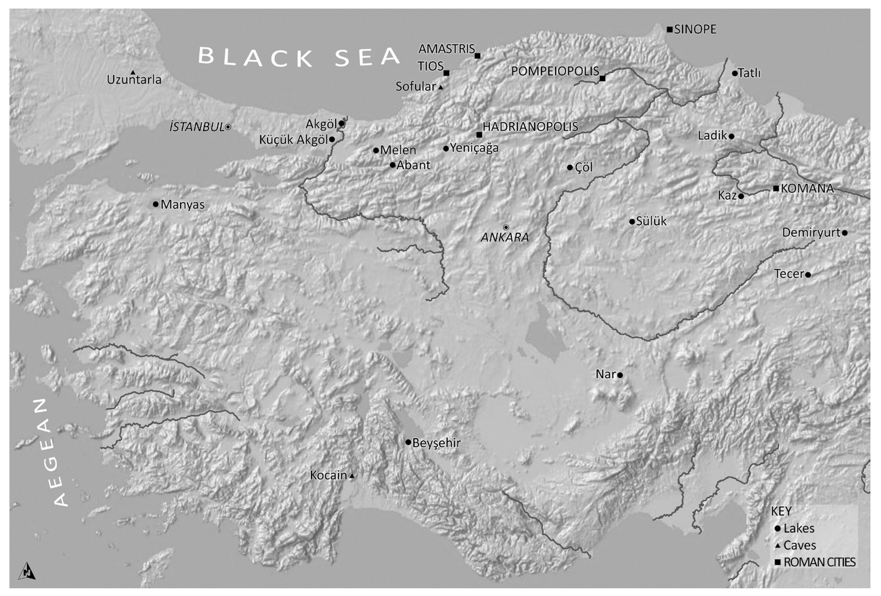
Exploring past climatic changes in the Roman Black Sea region is methodologically challenging, and palaeoenvironmental research is still in its infancy, although remarkable progress has been made through the availability of reliable hydrological records of high temporal resolution. These have provided palaeoclimate proxies sensitive to multiple climate signals (temperature, precipitation, and evaporation) from the southern Black Sea region. Geological archives allow regional palaeoclimate reconstructions through geochemical analysis of moisture-sensitive speleothem records derived from stalagmites in the Uzuntarla Cave in the southwestern Black Sea region in Turkish Thrace and the Sofular Cave located ca. 27 km southwest of the Roman seaport Tios (Figure 1). They show long-term and decadal to multi-decadal variations in humidity.

Figure 1.
Map of the southern Black Sea region: Roman cities and coring sites for lacustrine sediments and cave speleothems ©P. Johnson, using Esri World Shaded Relief and Hillshade basemaps.
The more widely deposited lacustrine sediments of lower temporal resolution available in the southwestern Black Sea region from Lakes Küçük Akgöl and Akgöl in the Sangarios River Valley in Sakarya Province, Lake Melen in Düzce Province, Lakes Abant and Yeniçağa in Bolu Province, Lake Ҫöl ca. 12 km east of Ҫankırı as well as in the central Black Sea region from Lake Tatlı in the Bafra plain, Lake Ladik northeast of Amasya, Lake Kaz southeast of Amasya, Lake Sülük east of Boğazköy and Lakes Demiryurt and Tecer in the Sivas region (Figure 1) can support palaeoclimate reconstructions through the analysis of morphological variation in their geochemical composition. This variation points to landscape changes possibly triggered by moisture stress from high levels of evaporation. Additionally, these lake sediments provide insights into changing vegetation and land use through variabilities in the pollen record that are, however, related to palaeoclimate change or changing economic systems and modes of agrarian production.
Let us start our survey with previous palaeoenvironmental research on the hinterland of the Pontic harbor city of Sinope. An intense expansion of rural settlements or large farmsteads, and possibly church-owned estates furnished with agricultural production facilities, can be observed from the fourth century onwards. This expansion is convincingly linked to an increase in the cultivation and processing of olives, which the pollen record indicates with a spike in olive pollen and a kiln site of centralized Late Roman amphora production in the Sinopean hinterland, probably connected to a villa estate or church property [43,44,45]. According to Izdebski, this intense agricultural exploitation of Sinopean land “was certainly due to the position of Sinop in the Roman commercial networks” [22] (p. 16); similarly [46] (pp. 93, 117); [43,44] and its engagement with long-distance Mediterranean trade. In contrast, the provisioning of the Eastern Roman capital, Constantinople, or the Roman army through the annona system, is thought not to have dominated economic transactions [47]. The abandonment of these rural settlements and farmsteads is considered to have been a direct consequence of either political turmoil during the Arab incursions [46] (pp. 117, 157) or palaeoclimate change and thus unfavorable climate conditions for oleoculture in the southern Black Sea region [44]. Both are proposed to have led to a sudden collapse of the local monocrop-oriented economy and the rural settlement system, but the timing of this change remains unclear and several dates have been suggested: the seventh century [43,44], agreed with by [48,49]; with doubts on the Late Roman settlement collapse: [22] (p. 36); the eighth century [46] (pp. 151, 156–157); [43,50] following a period of major infrastructural and agricultural investment and agro-economic intensification in the fourth century [43], similarly [18] or the fifth and sixth centuries [44]. While neither the dating of the archaeological survey material nor the pollen data derived from Lakes Ladik, Demiryurt and Kaz in the early 1990s with a dating precision that is no better than ±200 years due to lack of a chronostratigraphy based on AMS radiocarbon dating [18] allow a precise correlation of agrarian and settlement development, it is worth emphasizing that the abandonment of the intensively cultivated Sinopean lands may chronologically correspond with the recession in established agrarian regimes in northern Anatolia. This process has been roughly dated by pollen records around the middle of the fifth century [8,49], while some parts of northwest Anatolia experienced clear and abrupt changes in land use from intensive crop cultivation to (agro)pastoralism as early as from ca. 400 CE [51] or the fourth century onwards [12,21].
This remarkable decline in viti- and oleoculture and the cultivation of cereals, as well as a major increase in grazing weeds points to steppe vegetation and (agro)pastoral activities with low intensity cereal cropping typical of subsistence peasant farming, which generates agricultural products and raises livestock for a self-sufficient food supply. In northern Anatolia, this changing mode in land use and agroeconomic production was set into operation perhaps in the mid-fourth century, if we consider the chronological imprecision of the pollen data and the available information of the exceptionally well-dated palaeoclimatic record from Sofular Cave.
Located in the northern foothills of the Akçakoca Mountain range, the stalagmite stable-isotope record from Sofular Cave shows long-term and decadal to multi-decadal variations in effective moisture (Figure 1 and Figure 2). The stalagmite values analyzed through stable isotope ratios of carbon and oxygen are the most sensitive proxies for climate-driven changes in the local ecosystem [52]. Therefore, the Sofular speleothem “shows, for the first time, unequivocal evidence for a rapid and sensitive climate and ecosystem response in the eastern Mediterranean to GI [Greenland Interstadials]” which bears highly resolved and thus the most significant palaeoclimatic information for the Turkish Black Sea region [52] (p. 4).
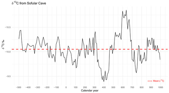
Figure 2.
High-resolution stable-isotope speleothem record from Sofular Cave, Prov. Zonguldak, indicating climate moisture conditions ©R. Busch, using the speleothem data available open access from https://www.ncei.noaa.gov/pub/data/paleo/speleothem/asia/turkey/sofular2009-noaa.txt (accessed on 13 February 2025).
Most interestingly, the high-resolution palaeohydrological proxy record shows relatively high precipitation until ca. 340 CE when the climate sharply turned towards enhanced aridity from ca. 360 to 440 CE, with a dry peak around 400 CE (Figure 2). This is the most significant hydroclimatic shift during the first millennium, and similarly, the oxygen isotope record from Lake Nar in central Anatolia attests to it, likewise well-dated by varves with annual to decadal precision in precipitation fluctuations [41]. According to Fleitmann and his team, who published the Sofular speleothem, this arid period is precisely dated by the stable-isotope record and strikingly coincides with pollen data that indicate steppe vegetation in the central and eastern Mediterranean [52]. As pointed out by Xoplaki, this extended dry weather condition caused a Late Roman megadrought, creating a large climate forcing covering not only the Black Sea area and the Anatolian Peninsula, but also the eastern Mediterranean [41]. Chronologically, this major drought corresponds to a decline in solar activity (ca. 370–435 CE)—the first phase of a prolonged period of significantly reduced solar radiation [53].
Historical sources provide causal links for the events and effects of these extreme dry weather conditions, such as a drought that caused famine between 451 and 454 CE in central and southeastern Anatolia and Palestine [18] (p. 126). Climate-related droughts are reported in the 360 s and 370 s during the much drier climatic phase from 340 CE onwards in different parts of Anatolia. Famine follows these in the early fifth century (ca. 400–435 CE), including a famine in Pontus and Paphlagonia (422 CE) and a grain shortage that struck Amaseia in the central Black Sea region (448–450 CE) [18]. A further shift towards more humid conditions in the eastern Mediterranean hydroclimate regime corresponds with the stalagmite record from the Uzuntarla Cave with its moisture proxies attesting to increased precipitation again only in the sixth century [41].
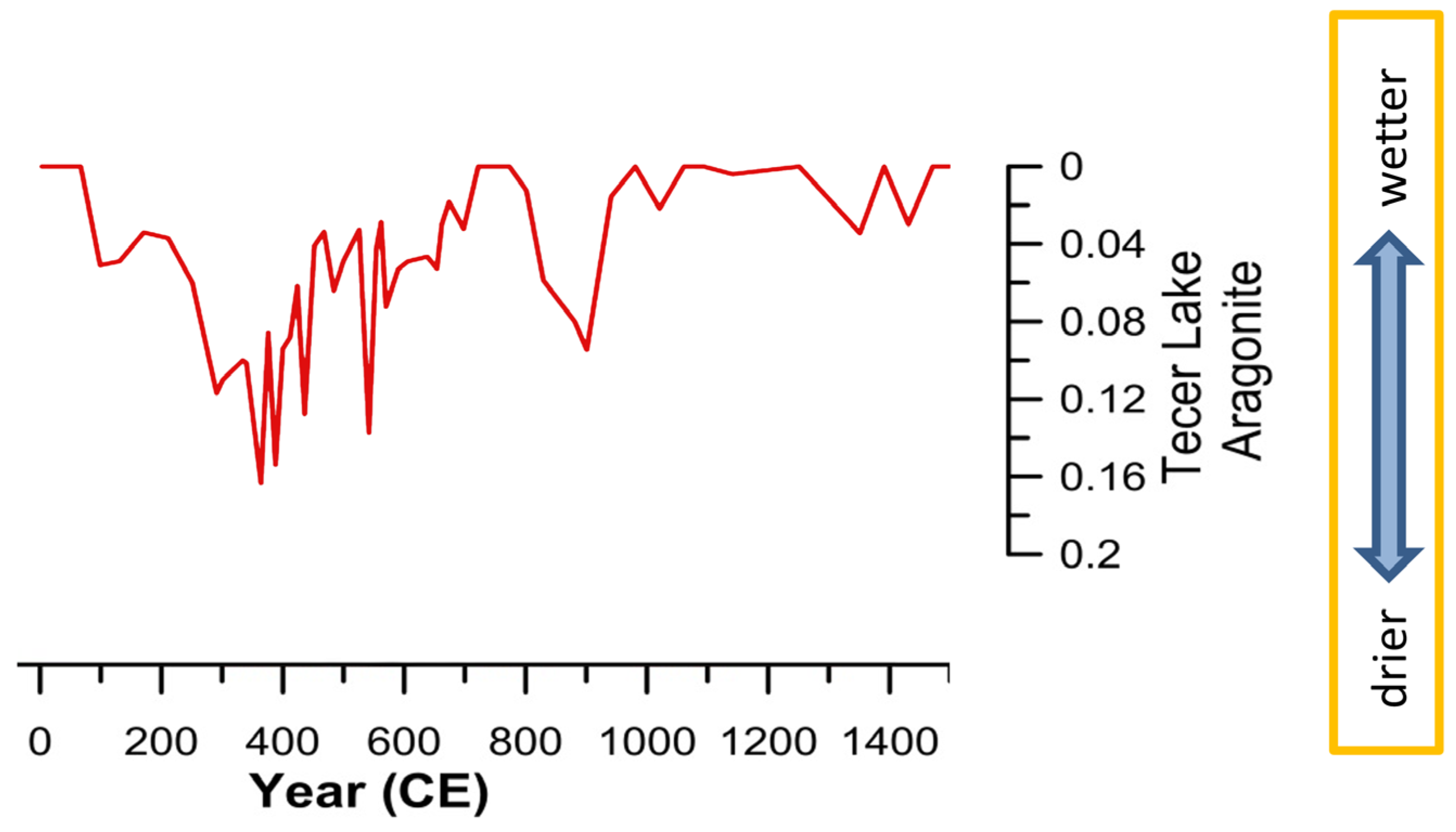
In the wider Pontic region, this Late Roman megadrought is attested and well-dated not only by the speleothem from Sofular Cave but also by the proxy data from Lake Tecer that points to moisture stress between ca. 360 and 440 CE (Figure 3) [54]. Another core sediment from Lake Çöl points towards a fifth-century drought [22] (p. 134) and an abrupt change indicated by salt inundation in the lacustrine sediment of Lake Manyas located south of the Marmara Sea points again to this palaeoecological change, roughly between 218 and 440 CE (according to recalibrated C14 data: [55]).
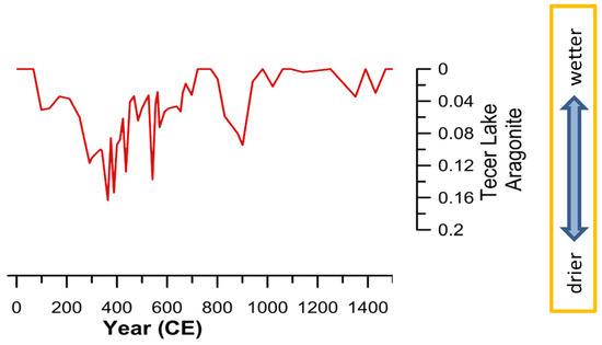
Figure 3.
Aragonite values of the lacustrine sediment sequence from Lake Tecer, Prov. Sivas, indicating evaporative conditions in the hydrological system © [18] (p. 124 Figure 1 modified by J. M. Koch).
Based on the sediment records from the Lakes Tecer, Nar and Çöl, Izdebski suggested that central Anatolia “suffered from a relatively strong drought around the fifth century” [22] (p. 135). The “fifth century Cappadocian drought” was seen as not to have caused any major changes in the vegetation pattern around Lake Nar [22] (p. 141), although a peak in steppe indicators dated ca. 560 CE points to a collapse of the agricultural regime around Lake Demiryurt [22] (p. 196). In the region of Lake Küçük Akgöl, a decrease in cereals points to a major decline of agriculture and an abandonment of farmland roughly around the late fifth century that enabled the regeneration of nature [22] (pp. 183, 186). This sequence is likewise attested in the increase in pine pollen at Lake Sülük, suggesting an expansion of pine forests between 400 and 650 CE [56].
Even though the timespan of the drought has more recently been adjusted towards the prolonged period 350–470 CE and is now considered to have caused socioeconomic difficulties and subsistence crises in Anatolia, it is still supposed to have brought about neither major societal changes nor a crisis in the socioeconomic system [19] (pp. 142–143); [20]. By contrast, it is proposed that “the abandoning of a complex agriculture involving a variety of cultivars and practices (…) was not a decision forced on it by external constraints, but rather a development towards economic specialisation making the best possible use of the location and environmental resources of the area” [47] (p. 358) with the result that “we can have no doubt that there existed various local centres of production and demand which were able to maintain this ancient system well into the Middle Ages” [47] (pp. 358–359).
In previous studies that suggest systemic continuity and an enduring Late Roman Beyşehir-Occupation-Phase-type vegetation in the Early Byzantine lands, the pollen stratigraphy was usually integrated into historical analyses as one coherent set of data. There is, however, a distinct change within this time period that can be traced in pollen deposits in Nar Lake with much more chronological accuracy than in lake sediments in the Black Sea region. Two phases that provide inferences on divergent types and intensities of agrarian land use can be clearly separated and well dated here: in the Late Roman period (300–450 CE) vine pollen are present, whereas in the Early Byzantine period (450–670 CE) vine is completely absent and grass pollen have an increase that attests to a grass-herb dominated steppe [13,14]. Similarly, the palynostratigraphy of an AMS-dated high-resolution pollen record from the Bereket Basin in the Western Taurus Mountains points to intensive crop cultivation until ca. 350 CE, with pastoral and minor cultivation activities setting in afterwards [57]. It is around 350 CE that “the driest episode during Roman times recorded at Bereket (…) had a major impact on soil dynamics and on the environment” [57] (p. 2212). This intense dry period of megadrought lasted from ca. 360 to 440 CE according to the recalibrated data [58]. Although the Bereket region never recovered from this breakdown of the agricultural system around the middle of the fourth century, which caused a shift away from the previous intensive crop cultivation, the sharp drop in land use was not seen as a contributing factor in the declining power of Rome nor in the large-scale changes in agricultural practices and modes of production [59] and the nearby city of Sagalassos did “not seem to have suffered very much from its effects” [58] (p. 264).
In the Black Sea region and beyond, dry climatic conditions prevailed between ca. 360–440 CE, and the changing palaeoclimate does appear to have had a lasting impact on the agricultural regime and the socio-economic system. Here, as pointed out by Neil Roberts, palaeoclimate change and environmental crisis were “acting not only as a stressor, but also as a stimulus to social evolution” [60] (p. 25). Changing modes of production from intensified agriculture to peasant economy triggered societal innovation and institutional change. Instead of focusing on temperature shifts and cooling intervals and tracing the impact of climate change mainly in the sixth and seventh centuries as a result of the LALIA, a more promising way forward may be to search for changing precipitation patterns, political ecologies, and ecosystems, and modifications to the tax system around the middle of the fourth century in order to elucidate the impact of a megadrought in Late Roman Anatolia and the Eastern Roman Empire. It thus stands to reason to consider the impact of palaeoclimate change on the fate of Rome’s political power in West Asia much earlier than in the seventh century and to reveal not only changing settlement patterns and modes of land use in the Roman Black Sea region, but also the trajectories of the political economy in the imperial landscapes. To establish firm links between the hydrological change of the Roman-era palaeoclimate and the changing agrarian regimes, we now turn to the urban granary in Pompeiopolis, partially unearthed through stratigraphic excavation between 2013 and 2016.
3. Granaries as Palaeoclimatic Proxy Data for Drought and Failures of Political Agroeconomies in the Roman Black Sea Region—Evidence from the Urban Granary in Pompeiopolis
During Augustus’ provincial reorganization of the Anatolian Peninsula, the territory of Pompeiopolis was annexed to the province of Galatia in 6/5 BCE. Additionally, the Roman in-kind tax system, which demanded intensified cereal agriculture to feed the Roman army stationed along the Pontic limes, had most probably been implemented concurrently with the basic imperial infrastructure only a few decades after the military submission of the region to Pompey. Serving the needs of Roman imperial urbanism (on this model see [24]) and demanding the urbanization of the former realm of the Pontic kings in inland Paphlagonia for the first time, this infrastructure left its archaeological footprint in the city’s center (Figure 4).

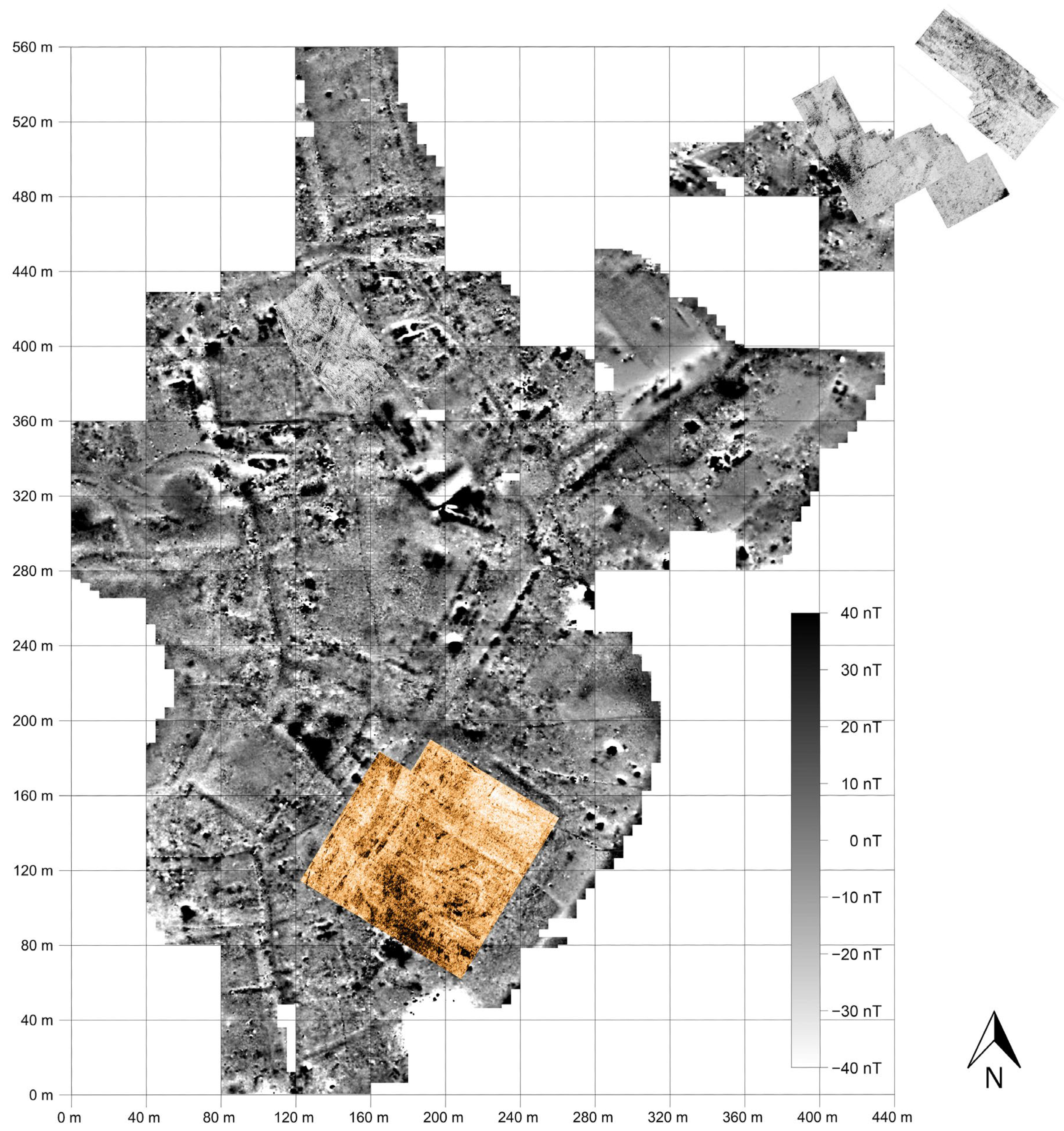
Figure 4.
Magnetogram of the city center of Pompeiopolis on Zımbıllı Tepe; on the southern terrace, the area of the courtyard granary investigated through ground-penetrating radar ©Pompeiopolis Excavation Archive.
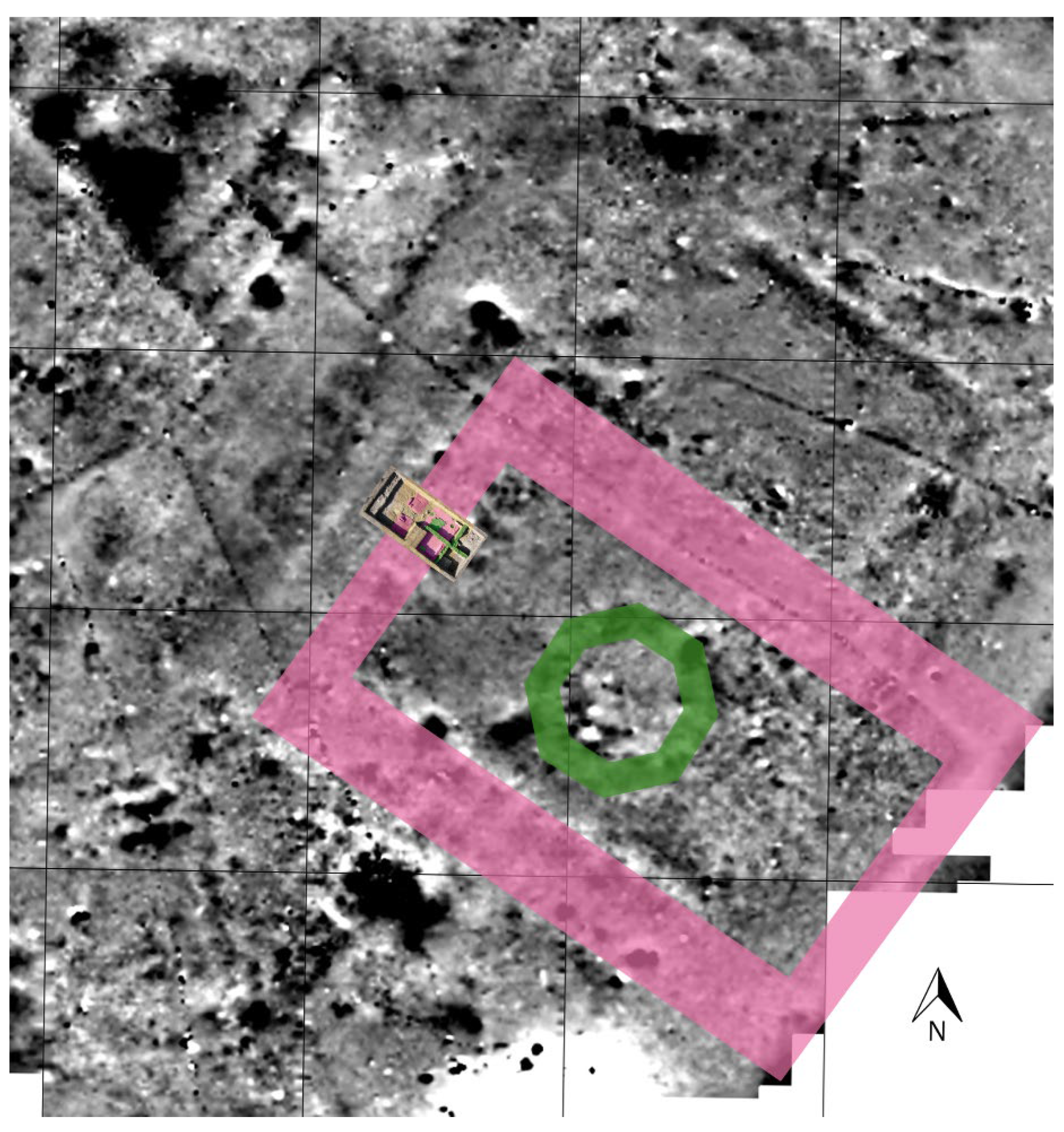
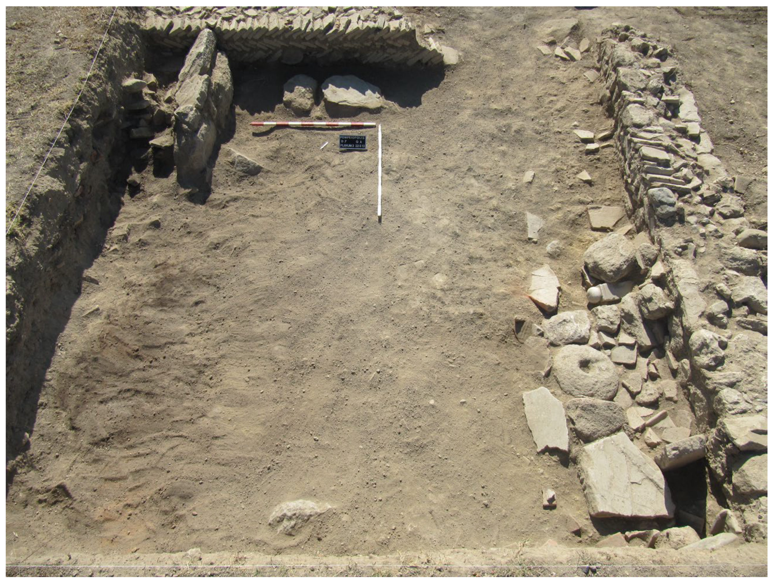
Above the banks of the Amnias River on the southern terrace of Zımbıllı Tepe and along the city’s main street close to the agora, one monumental building measuring ca. 68 × 98 m was identified as a peristyle courtyard granary serving for the large-scale storage of grain taxes due to its size, building typology (Figure 5), construction technique (Figure 6), and the empire’s general demand to set up and run central collection points for the imperial annona throughout its provinces.
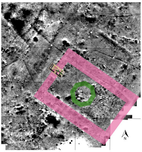
Figure 5.
The courtyard granary in Pompeiopolis. In the northwestern wing, the excavation trench. Two building phases are presented on the magnetogram: the mid-Augustan courtyard granary (colored in violet) and its partial rebuilding with the construction of an octagonal martyrion church in the open court in the early fourth century (colored in green) ©J. M. Koch.
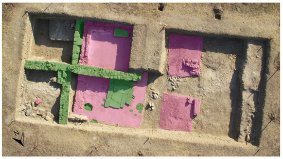
Figure 6.
Excavation trench in the northwestern wing showing the Early Roman architecture (colored in violet) and the Late Roman partial (re)construction with architectural modifications (colored in green) ©J. M. Koch.
A sophisticated imperial redistribution system based on a network of urban granaries is anticipated in Roman borderlands such as the mostly rockbound coast of the limes Ponticus around Sinope and Amastris (Figure 1), which provided only very limited fertile land in order to secure military supply lines. While it is not possible to determine the function of urban granaries as centralized tax collection and redistribution points simply from their architectural design and spatial layout, their significance for annona transactions underlies an exceptional inscription from Larisa that reports the shipment of Thessalian grain to Rome from the Thessalian inland poleis via harbor cities [61].
Distinctive architectural features of the urban granary at Pompeiopolis, such as the colonnaded porch paved with travertine, gutters for draining rainwater into sewage systems, storerooms with buttressed walls, walls built of opus quadratum and waterproof floors built of opus signinum (Figure 6) closely resemble the courtyard granaries in Augustan Rome and Ostia, e.g., the Augustan Horrea Agrippiana below the Palatine next to the Forum Romanum, the Horrea Lolliana and the Horrea Galbana on the banks of the Tiber River, and the Iulio-Claudian Horrea of Hortensius located at the mouth of the Tiber at Rome’s port at Ostia. The last had a working space of ca. 6000 m2 available, which comes closest to the ca. 6664 m2 of working space of the rectangular court at Pompeiopolis (see [24] for details of the architectural features and archaeological finds described in this section). Whereas the Storehouse of Hortensius was lately considered as an example of privately owned horrea [62] similar to the Republican storehouses in Rome associated with aristocratic families [63] (p. 188), large-size urban granaries located in public spaces are likely state or publicly owned storehouses administered by (and named after) members of the local elite commissioned by a city’s authorities.
Urban granaries in Hispania, which are supposed to have supplied Roman towns by satisfying their territory’s commercial needs and guaranteeing the local population’s food supply, were regularly constructed during Rome’s expansion and subsequent consolidation of power on the Iberian Peninsula [63] (p. 188). According to the Asian customs law referring to an export of tax-grain in 62 CE [64] (p. 219), »a tithe of the crops produced by the plough or a fifth of the wine or the oil« had to be handed over to the publicani who were in charge of extracting the taxes in kind on the Anatolian Peninsula [65] (p. 55); [66] (p. 218). In the early second century, Dion of Prusa in his speech addressed to the citizens of Nikomedeia explicitly mentions the tax in kind (tithe) of the Bithynians [66] (p. 218). Therefore, public storage facilities were needed for the stockpiling of taxed staple goods in northern Anatolia (and beyond) and the courtyard granary at Pompeiopolis was certainly well equipped to serve as a publicly owned fiscal storehouse for the centralized storage of grain taxes before their further shipment by the Amnias River towards the Halys and the Black Sea (Figure 1).
This reading of the urban granary at Pompeiopolis is in line with the previously reconstructed function of the courtyard granaries in Rome and Ostia as state or publicly owned storehouses for the city’s corn supply as suggested by Geoffrey Rickman in his seminal study on Roman Granaries and Store Buildings [67] (pp. 53, 69, 174). Similarly, in Roman Gaul, an urban courtyard granary echoing its Italian predecessors has been associated with imperially administered grain storage and the food supply of the Roman army stationed along the northern frontier [68] (pp. 83–84). Imperial administration of peristyle courtyard granaries built in the first century becomes even more clear at Roman military sites, for example, on the Lower Rhine limes at the legionary fortress of Novaesium [67] (pp. 255–257); [69] (pp. 186–188 pl. 16 buildings no. 21–22), and already Caesar during his civil war against Pompey relied on grain supplies sent to military camps from urban granaries [70] (p. 587). In Pompeiopolis, this redistributive, institutionalized system of Roman taxation in kind newly comes to the fore in the city’s management of large-scale grain storage.
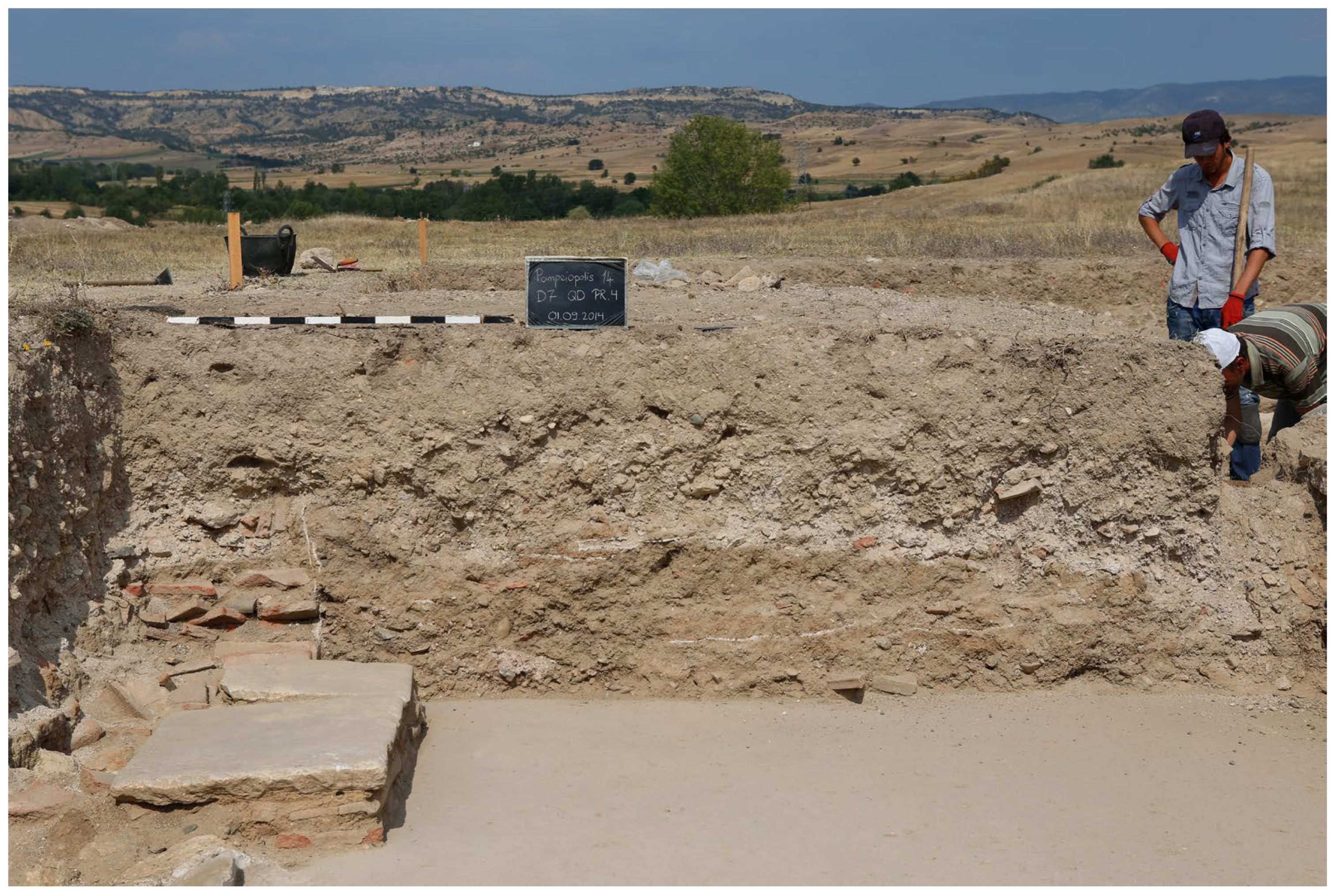
Surprisingly, this most probably mid-Augustan urban granary, which incorporated a double-spaced northwestern wing with two-fold cellular storage units measuring 6.7 m in width and 4.4 m in depth (front rooms) and 2.4 m in depth (rear rooms, about half size in width) (Figure 5 and Figure 6), was destroyed by fire in the late second or early third century (at the latest). This is according to the most recent finds of Pontic Sigillata, Early Roman coarse ware, and a fragment of a late secondcentury inscription within the building debris covering the rear rooms.
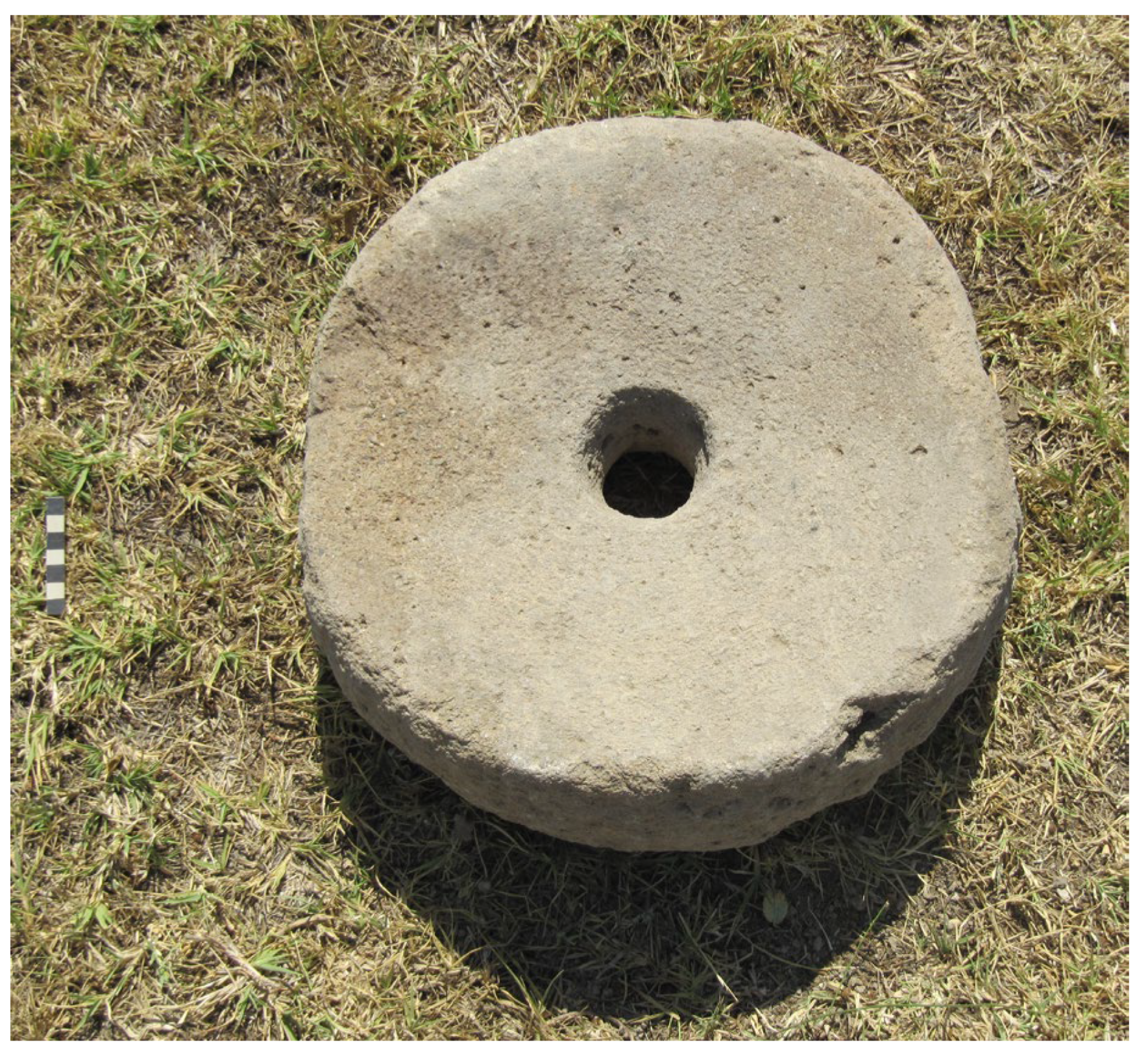
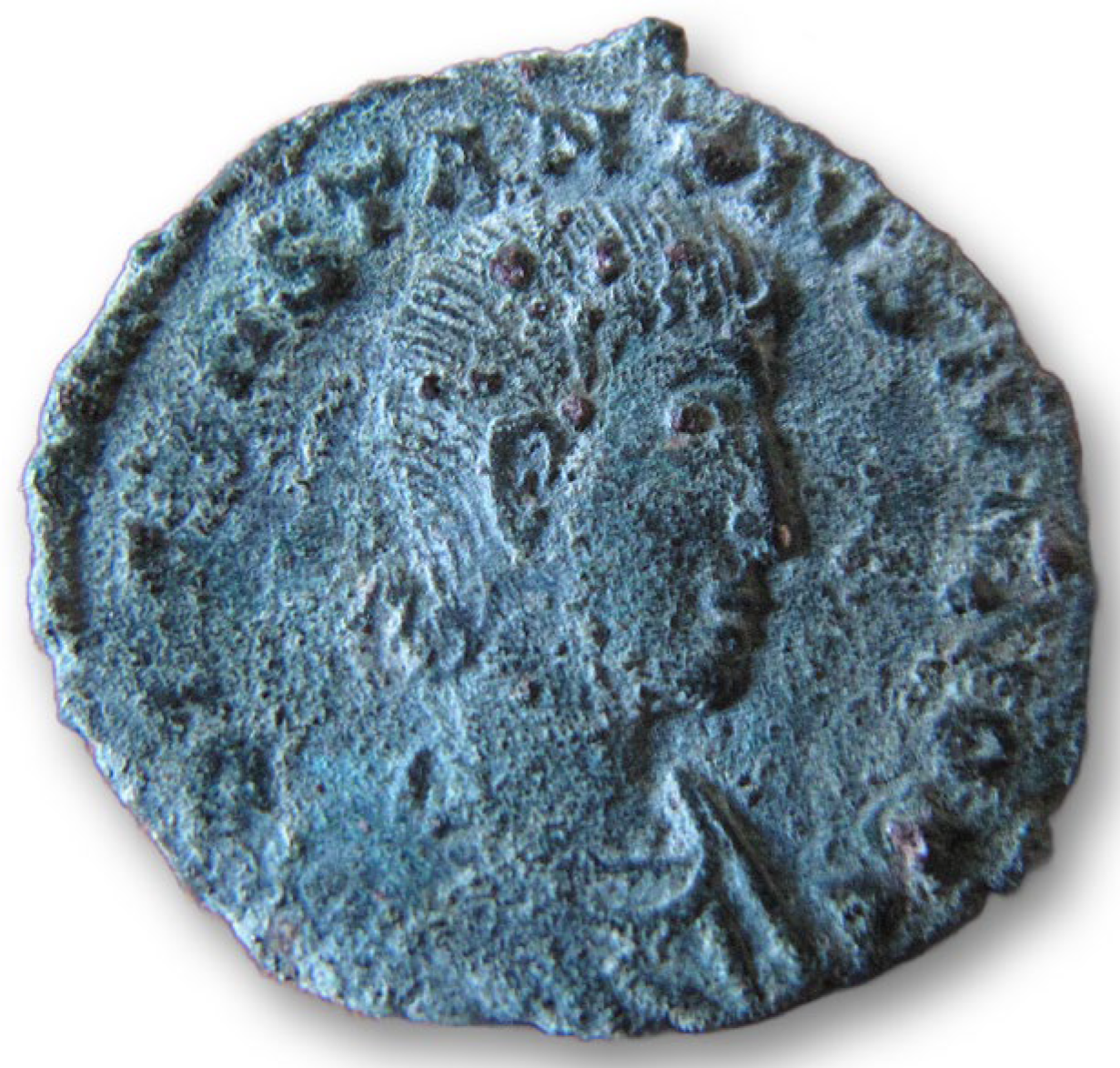
The wing was left derelict for decades before it was partially rebuilt in the early fourth century as a churchyard granary that centered on an octagonal martyrion (Figure 5 and Figure 6). Already around the middle of the fourth century, the rebuilt grain storage and processing facility newly furnished with sunken pithoi—similar to the Late Roman pithoi found in situ east of the churchyard granary—and grinding stones anchored in the circular holes of the cemented floor (Figure 6, Figure 7, Figure 8 and Figure 9) fell out of use again during the reign of Constantius II between 351 and 355 CE, according to a coin that was recovered directly atop the floor underneath the collapsed wall of the anterior room of the northwestern wing (Figure 10 and Figure 11). After the collapse of the reused Early Roman walls, the Late Roman churchyard granary was never rebuilt, and the absence of occupational layers dating to the later fourth, fifth, and sixth centuries clearly reflects the abandonment of the urban settlement on the southern plateau of Zımbıllı Tepe.

Figure 7.
Grinding stone found in the northwestern wing of the courtyard granary ©J. M. Koch.
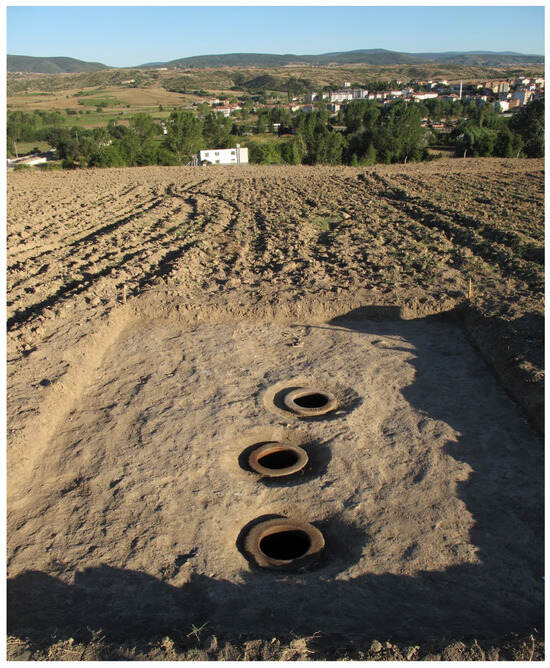
Figure 8.
Storage facility on the southeastern terrace of Zımbıllı Tepe, including three Late Roman pithoi for the storage of grain excavated during a rescue excavation in 2015 ©J. M. Koch.
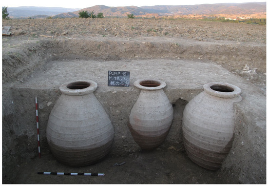
Figure 9.
Late Roman pithoi excavated in the storage facility in the city center of Pompeiopolis, east of the courtyard granary ©J. M. Koch.
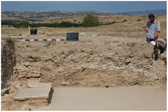
Figure 10.
Collapsed pisé wall of the excavated room adjoining the court in the northwestern wing of the mid-Augustan courtyard granary. Underneath this collapsed wall, directly atop the cemented floor, the bronze coin minted during the reign of Constantius II was found ©J. M. Koch.
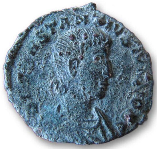
Figure 11.
Bronze coin minted during the reign of Constantius II (351–355 CE) found beneath the collapsed wall of the courtyard granary ©J. M. Koch.
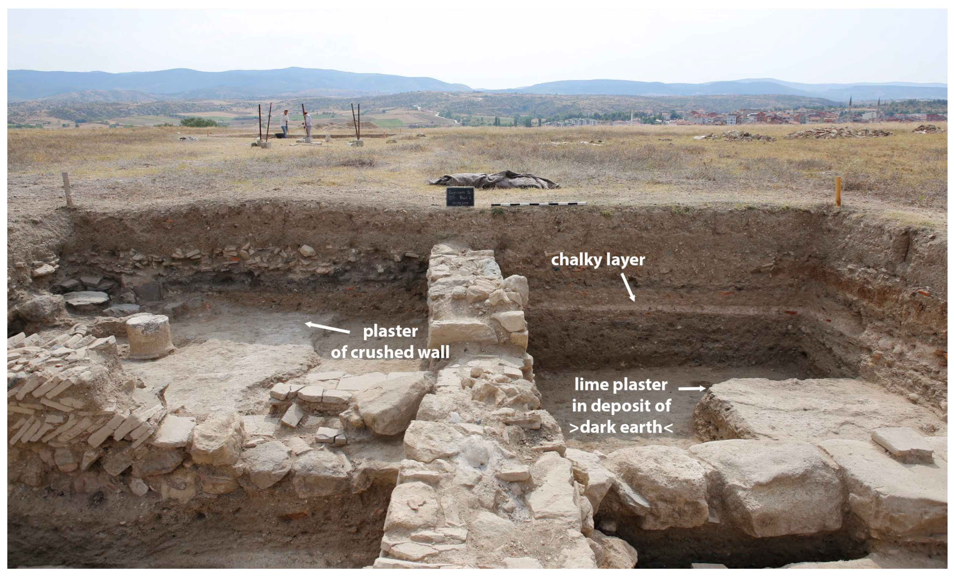
In the late fourth century, the martyrion was transformed into a cemetery church and the court of the granary was filled with earthen debris: large-scale dumping activities that raised the ground level to create a new burial ground ad sanctos (centering on the cemetery church) that extended further towards the derelict peristyle wings until the early seventh century. In the area of the derelict northwestern wing and its porch, chalky layers and residues of lime plaster were observed in the earthen debris filling of “dark earth” (Figure 12). These residues of lime plaster and the chalky deposit point to the preparation of plaster burials and chalk-packed burials after 631/2 CE but prior to 656 CE that met the increased hygiene and thus public security measures in the aftermath of the devastating Iustinianic Plague, which started to spread throughout Anatolia in 541/2 CE.
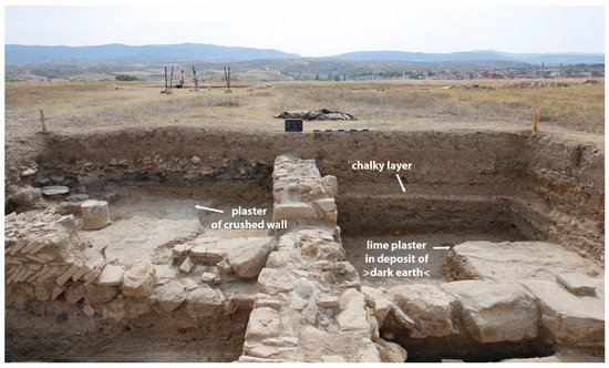
Figure 12.
Residues for the preparation of plaster burials at the burial ground at sanctos in the derelict porch of the abandoned granary ©J. M. Koch.
Instead of the centralized storage of grain, subsequent efforts at the centralized storage of raw materials ready to be fed to lime kilns are indicated by the building of a humble storage facility built of pine wood at the derelict site of the churchyard granary around 656 CE (Figure 13). The reactivation of the “City of Pompey” as a central place during the reign of Constans II (641–668 CE) may reflect another imperial attempt to rebuild the city in order to sustain the Eastern Roman Empire against all odds—or may simply point to the reuse of the communal cemetery and the need for lime for plaster burials instead of any attempt at urban restoration.

Figure 13.
Raw material storage for lime production in the Early Byzantine humble building (ca. 656 CE) reusing the partly preserved Late Roman architecture of the granary ©J. M. Koch.
The final abandonment of Zımbıllı Tepe and its humble storage facility came after another destructive fire event shortly after the middle of the seventh century, around 656/7 CE, during the period of the Arab raids (Figure 14). In any case, the Late Roman “City of Pompey” with its economic polis administration for collecting taxes in kind from the city’s fertile territory had vanished already centuries earlier, around the middle of the fourth century, when the city center of Pompeiopolis was turned into a “city of the dead”.
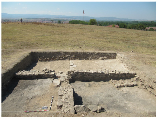
Figure 14.
Ashy layer of pine wood of the humble Early Byzantine storage building burnt down shortly after the mid-seventh century before the final abandonment of the cemetery ©J. M. Koch.
According to our excavation results, the ›polis command economy‹ that contributed to a redistributive and integrated political economy of the tributary Roman state and exploited cellular microregional command ecologies through large-scale storage of taxed agrarian resources—first, in the Early Roman courtyard granary and subsequently in the Late Roman churchyard granary—had thus failed repeatedly (at least twice) in the Black Sea region.
4. Conclusions—Reassessing the Fragmentation and “Fall” of Rome’s Empire: The Impact of Climate Change on Ecologies and Command Economies
Harper’s assumption that droughts and food shortages, and the Antonine Plague led to the “first fall” of Rome’s early empire has not been discussed in this short article, although a dry period during the reign of Trajan—as indicated in the Sofular speleothem (Figure 2)—may have triggered a disintegrated economic system in this region already during the first two decades of the second century, see [24]. In the past, “historians took the stability of the early imperial system for granted”, while nowadays, the Roman imperial economy and “the urban system as a whole looks less stable” [6] (p. 411). At Pompeiopolis, the abandoned granary was left derelict in the late second or early third century, and its rebuilding in the early fourth century attests to a period of systemic crisis during the third century in the Black Sea region. This crisis, evident in many regions of the Anatolian Peninsula and beyond, see [24], thus offers some support to Harper’s thesis of the “first fall” of Rome’s empire. Again, around 360 CE, instead of severe temperature shifts and epochal cooling, the Roman Empire was struck by a centennial megadrought, triggering systemic collapse. In the southern Black Sea region, we are able to initially establish firm causal links between severe drought, harvest failures, and the collapse of the imperial agroeconomy. As indicated by the abandoned granary, the Late Roman megadrought (ca. 360–440 CE) caused major disturbances within the ecosystem and the agrarian command economy. Paphlagonian societies adapted to these conditions from the middle of the fourth century by changing modes of agricultural production and scales of agroeconomic performance. The pollen data provide the evidence for changing land use, from intensified agriculture towards (agro)pastoralism. These climate-related changes in land use imply systemic change, from the redistributive ›polis command economy‹ that secured the vulnerable supply lines of Roman military sites to peasant-based agrarian management. In consequence, this significant shift in land use and the agrarian regimes, from intensified cereal-based agriculture and both oleo- and viticulture to a less labor-intensive agropastoral economy shortly after the middle of the fourth century is most likely to have acted as a causal force in the collapse not only of Rome’s political economy, but also the imperial regime. In Pompeiopolis, we were able to trace poleis turned into necropoleis, disintegrated agroeconomies on a microregional scale, and the dysfunctional fiscal system on the macroeconomic level.
Our detailed multi-disciplinary study in the Roman Black Sea region—by integrating the available archaeological, palaeoclimatic, and palaeoecological data into historical research—points towards palaeoclimate change as a forcing mechanism in the systemic collapse of Rome’s redistributive ›polis command economy‹ that triggered the failure of Rome’s imperial regime and thus the fragmentation of Rome’s empire in the East from as early as around 360 CE. Integrating the palaeoclimatic data into the history of the city granary in Pompeiopolis challenges the traditional view of the turning points in the history of the Eastern Roman Empire and prompts closer looks at northern Anatolian cities in the middle or later fourth century. As a consequence of the breakdown of imperial urbanism, institutional arrangements, and the political command economy of the Early and Late Roman state, the first excavation of a courtyard granary in Anatolia may be a promising way ahead to search for modes and moments of institutional change, more specific strategies for state and societal resilience in times of palaeoclimate change, and the impact of state taxation in the Roman world.
By associating the abandonment of the urban granary at Pompeiopolis with palaeoclimate change, it is also hoped to promote further in-depth studies on public granaries as a source of proxy data for failures of grain harvests because of extreme weather conditions and climatological research in general, as recently suggested [71]. Therefore, as archaeologists, we need to focus on the archaeology of taxation and urban economic architecture besides agorai and their supposed commercial markets, and we also need to supplement the fine-grained excavation of urban sites with rural lands and farmsteads.
Funding
The APC was funded by Princeton University’s Climate Change and History Research Initiative.
Data Availability Statement
The data that support the findings at the granary in Pompeiopolis will be available soon in [24].
Acknowledgments
This paper greatly benefitted from the exchange of ideas during several meetings of the 7th Research Network organized by the Istanbul Department of the German Archaeological Institute in collaboration with Koç University’s Research Center for Anatolian Civilizations and Princeton University’s Climate Change and History Research Initiative for exploring Socio-Ecological Approaches to the History and Archaeology of Anatolia (2023–2025) and I thank all the participants of this DAI research network for very much inspiring discussions opening up new perspectives on palaeoenvironmental research and the archaeology of climate change. Especially, I wish to express my gratitude to R. Busch (FU Berlin) for providing me with support in newly plotting the data from the Sofular Cave speleothem and P. Johnson (University of Illinois, Chicago) for mapping all the coring sites discussed in this paper. I also thank S. Steadman (State University of New York) and J. F. Haldon (Princeton University) for their invitation to contribute to this Special Issue of the Heritage Journal on The Archaeology of Climate Change, the German Archaeological Institute for granting me a DAI Research Fellowship dedicated to the spatial exploration of conflict landscapes in the Post-Satrapal and Roman Black Sea region, and especially F. Pirson (German Archaeological Institute, Istanbul Department) for supporting my studies in Anatolian palaeoenvironmental archaeology. F. Pirson, R. Busch, P. Johnson, L. Summerer, and both Sharon and John as co-editors of the Heritage Journal SI sparked my interest in integrating palaeoclimate and palynological data into my archaeological research. I thank them and the two external reviewers for their helpful comments on an earlier draft of this paper, and I am grateful to Princeton University’s Climate Change and History Research Initiative for granting me a generous publication fund. I dedicate this essay to J. Diehl, J. Pfalz, C. Sauvin, and my Turkish–German student team in Hadrianopolis, who is eager to shape the future of archaeo-environmental research in the Roman Black Sea region, and to Benjamin whose sensitivity for ecological change and curiosity about cosmic activities is simply astonishing and very much inspiring.
Conflicts of Interest
The author declares no conflict of interest.
References
- Harper, K. The Fate of Rome—Climate, Disease, and the End of an Empire; Princeton University Press: Princeton, NJ, USA, 2017. [Google Scholar]
- McCormick, M.; Büntgen, U.; Cane, M.A.; Cook, E.R.; Harper, K.; Huybers, P.; Litt, T.; Manning, S.W.; Mayewski, P.A.; More, A.F.M.; et al. Climate Change during and after the Roman Empire: Reconstructing the Past from Scientific and Historical Evidence. J. Interdiscip. Hist. 2012, 43, 169–220. [Google Scholar] [CrossRef]
- Harper, K. Contours of Environmental Change and Human Response in Late Antiquity. In Environment and Society in the Long Late Antiquity; Izdebski, A., Mulryan, M., Eds.; Brill: Leiden, The Netherlands, 2019; pp. 355–360. [Google Scholar]
- Harper, K.; McCormick, M. Reconstructing the Roman Climate. In The Science of Roman History—Biology, Climate, and the Future of the Past; Scheidel, W., Ed.; Princeton University Press: Princeton, NJ, USA, 2018; pp. 11–52. [Google Scholar]
- Büntgen, U.; Myglan, V.S.; Ljungqvist, F.C.; McCormick, M.; Di Cosmo, N.; Sigl, M.; Jungclaus, J.; Wagner, S.; Krusic, P.J.; Esper, J.; et al. Cooling and Societal Change during the Late Antique Little Ice Age from 536 to around 660 AD. Nat. Geosci. 2016, 9, 231–236. [Google Scholar] [CrossRef]
- Woolf, G. The Life and Death of Ancient Cities—A Natural History; Oxford University Press: Oxford, UK, 2020. [Google Scholar]
- Xoplaki, E.; Luterbacher, J.; Wagner, S.; Zorita, E.; Fleitmann, D.; Preiser-Kapeller, J.; Sargent, A.M.; White, S.; Toreti, A.; Haldon, J.F.; et al. Modelling Climate and Societal Resilience in the Eastern Mediterranean in the Last Millennium. Hum. Ecol. 2018, 46, 363–379. [Google Scholar] [CrossRef]
- Haldon, J. Euchaïta: From Late Roman and Byzantine Town to Ottoman Village. In Archaeology and Urban Settlement in Late Roman and Byzantine Anatolia—Euchaïta-Avkat-Beyözü and Its Environment; Haldon, J., Elton, H., Newhard, J., Eds.; Cambridge University Press: Cambridge, UK, 2018; pp. 210–254. [Google Scholar]
- Haldon, J. Some Thoughts on Climate Change, Local Environment, and Grain Production in Byzantine Northern Anatolia. In Environment and Society in the Long Late Antiquity; Izdebski, A., Mulryan, M., Eds.; Brill: Leiden, The Netherlands, 2019; pp. 200–206. [Google Scholar]
- Haldon, J.; Elton, H.; Izdebski, A. Managing the Roman Empire for the Long Term: Risk Assessment and Management Policy in the Fifth to Seventh Centuries. In Perspectives on Public Policy in Societal-Environmental Crises—What the Future Needs from History; Izdebski, A., Haldon, J., Filipkowski, P., Eds.; Springer Nature Switzerland AG: Cham, Switzerland, 2022; pp. 237–246. [Google Scholar]
- Izdebski, A. Catastrophes Aside: Environment and the End of Antiquity. In Environment and Society in the Long Late Antiquity; Izdebski, A., Mulryan, M., Eds.; Brill: Leiden, The Netherlands, 2019; pp. 367–370. [Google Scholar]
- Roberts, N. Revisiting the Beyşehir Occupation Phase: Land-Cover Change and the Rural Economy in the Eastern Mediterranean during the First Millenium AD. In Environment and Society in the Long Late Antiquity; Izdebski, A., Mulryan, M., Eds.; Brill: Leiden, The Netherlands, 2019; pp. 53–68. [Google Scholar]
- Eastwood, W.J.; Gümüşçü, O.; Yiğitbaşıoğlu, H.; Haldon, J.F.; England, A. Integrating Palaeoecological and Archaeo-Historical Records: Land Use and Landscape Change in Cappadocia (Central Turkey) since Late Antiquity. In Archaeology of the Countryside in Medieval Anatolia; Vorderstrasse, T., Roodenberg, J., Eds.; Nederlands Instituut voor het Nabije Oosten: Leiden, The Netherlands, 2009; pp. 45–69. [Google Scholar]
- England, A.; Eastwood, W.J.; Roberts, C.N.; Turner, R.; Haldon, J.F. Historical Landscape Change in Cappadocia (Central Turkey): A Palaeoecological Investigation of Annually Laminated Sediments from Nar Lake. Holocene 2008, 18, 1229–1245. [Google Scholar] [CrossRef]
- Haldon, J. ”Cappadocia will be Given Over to Ruin and Become a Desert”—Environmental Evidence for Historically-Attested Events in the 7th–10th Centuries. In Byzantina Mediterranea—Festschrift für Johannes Koder zum 65. Geburtstag; Belke, K., Kislinger, E., Külzer, A., Stassinopoulou, M.A., Eds.; Böhlau: Vienna, Austria, 2007; pp. 215–230. [Google Scholar]
- Haldon, J. Historicizing Resilience: The Paradox of the Medieval East Roman State—Collapse, Adaptation, and Survival. In Empires and Communities in the Post-Roman and Islamic World; Pohl, W., Kramer, R., Eds.; Oxford University Press: Oxford, UK, 2021; pp. 89–120. [Google Scholar]
- Haldon, J. Remarks on History, Environment, and Climate in Byzantine Anatolia: Comments on a Complex Landscape. In Space and Communities in Byzantine Anatolia—Papers from the Fifth International Sevgi Gönül Byzantine Studies Symposium; Kontogiannis, N.D., Uyar, T.B., Eds.; Koç University Press: Istanbul, Turkey, 2021; pp. 3–17. [Google Scholar]
- Haldon, J.; Roberts, N.; Izdebski, A.; Fleitmann, D.; McCormick, M.; Cassis, M.; Doonan, O.; Eastwood, W.; Elton, H.; Ladstätter, S.; et al. The Climate and Environment of Byzantine Anatolia: Integrating Science, History, and Archaeology. J. Interdiscip. Hist. 2014, 45, 113–161. [Google Scholar] [CrossRef]
- Izdebski, A. Ein Vormoderner Staat als Sozioökologisches System—Das Oströmische Reich 300—1300 n. Chr.; Sandstein: Dresden, Germany, 2021. [Google Scholar]
- Izdebski, A.; Pickett, J.; Roberts, N.; Waliszewski, T. The Environmental, Archaeological and Historical Evidence for Regional Climatic Changes and Their Societal Impacts in the Eastern Mediterranean in Late Antiquity. Quat. Sci. Rev. 2016, 136, 189–208. [Google Scholar] [CrossRef]
- Roberts, N.; Cassis, M.; Doonan, O.; Eastwood, W.; Elton, H.; Haldon, J.; Izdebski, A.; Newhard, J. Not the End of the World? Post-Classical Decline and Recovery in Rural Anatolia. Hum. Ecol. 2018, 46, 305–322. [Google Scholar] [CrossRef]
- Izdebski, A. A Rural Economy in Transition: Asia Minor from Late Antiquity into the Early Middle Ages; Rafała Taubenschlaga: Warsaw, Poland, 2013. [Google Scholar]
- Izdebski, A. The Environmental Consequences of the Coming of the Turks to Anatolia. In Winds of Change—Environment and Society in Anatolia; Roosevelt, C.H., Haldon, J.F., Eds.; Koç University Press: Istanbul, Turkey, 2021; pp. 229–249. [Google Scholar]
- Koch, J.M. Imperial Urbanism and Staple Economies in the Early and Late Roman Cityscape—Spatial Transformations of the Courtyard Granary at Pompeiopolis (1st cent. BCE—7th cent. CE). In Contextualizing Pompeiopolis—Urban Development in Roman Anatolia from a Comparative Perspective; Summerer, L., Johnson, P., Koch, J.M., Eds.; De Gruyter: Berlin, Germany, 2025; forthcoming. [Google Scholar]
- Izdebski, A.; Mordechai, L.; White, S. The Social Burden of Resilience: A Historical Perspective. Hum. Ecol. 2018, 46, 291–303. [Google Scholar] [CrossRef]
- Weiss, H. (Ed.) Megadrought and Collapse: From Early Agriculture to Angkor; Oxford University Press: Oxford, UK, 2017. [Google Scholar]
- Chew, S.C. The Recurring Dark Ages—Ecological Stress, Climate Changes and System Transformation; AltaMira Press: Lanham, MD, USA, 2007. [Google Scholar]
- Manning, J.G. The Open Sea—The Economic Life of the Ancient Mediterranean World from the Iron Age to the Rise of Rome; Princeton University Press: Princeton, NJ, USA, 2018. [Google Scholar]
- Woolf, G. Rome—An Empire’s Story; Oxford University Press: Oxford, UK, 2022. [Google Scholar]
- Haldon, J.; Elton, H.; Huebner, S.R.; Izdebski, A.; Mordechai, L.; Newfield, T.P. Plagues, Climate Change, and the End of an Empire: A Response to Kyle Harper’s The Fate of Rome (1): Climate. Hist. Compass 2018, 16, e12508. [Google Scholar] [CrossRef]
- Erdkamp, P. Climate Change and the Productive Landscape in the Mediterranean Region in the Roman Period. In Climate Change and Ancient Societies in Europe and the Near East—Diversity in Collapse and Resilience; Erdkamp, P., Manning, J.G., Verboven, K., Eds.; Springer Nature Switzerland AG: Cham, Switzerland, 2021; pp. 411–442. [Google Scholar]
- Haldon, J.; Elton, H.; Huebner, S.R.; Izdebski, A.; Mordechai, L.; Newfield, T.P. Plagues, Climate Change, and the End of an Empire: A Response to Kyle Harper’s The Fate of Rome (3): Disease, Agency, and Collapse. Hist. Compass 2018, 16, e12507. [Google Scholar] [CrossRef]
- Haldon, J.; Rosen, A. Society and Environment in the East Mediterranean ca. 300–1800 CE. Problems of Resilience, Adaptation, and Transformation. Introductory Essay. Hum. Ecol. 2018, 46, 275–290. [Google Scholar] [CrossRef]
- Marston, J.M.; Castellano, L. Climate, Political Economy and Agriculture in First and Second Millennia AD Anatolia. Antiquity 2025, 99, 440–461. [Google Scholar] [CrossRef]
- Jacobson, M.J.; Pickett, J.; Gascoigne, A.; Elton, H.; Fleitmann, D. Settlement, Environment, and Climate Change in SW Anatolia: Dynamics of Regional Variation and the End of Antiquity. PLoS ONE 2022, 17, e0270295. [Google Scholar] [CrossRef] [PubMed]
- Labuhn, I.; Finné, M.; Izdebski, A.; Roberts, N.; Woodbridge, J. Climatic Changes and Their Impacts in the Mediterranean during the First Millenium AD. In Environment and Society in the Long Late Antiquity; Izdebski, A., Mulryan, M., Eds.; Brill: Leiden, The Netherlands, 2019; pp. 247–270. [Google Scholar]
- Jacobson, M.J. Climate Change and Socioeconomic Transformations in the Late Antique Eastern Mediterranean and Middle East. Ph.D. Dissertation, University of Reading, Reading, UK, 2021. [Google Scholar]
- Waelkens, M.; Paulissen, E.; Vermoere, M.; Degryse, P.; Celis, D.; Schroyen, K.; De Cupere, B.; Librecht, I.; Nackaerts, K.; Vanhaverbeke, H.; et al. Man and Environment in the Territory of Sagalassos, A Classical City in SW Turkey. Quat. Sci. Rev. 1999, 18, 697–709. [Google Scholar] [CrossRef]
- Eastwood, W.J.; Yığıtbaşıoğlu, H. Geology, Geomorphology and Palaeoenvironments. In Archaeology and Urban Settlement in Late Roman and Byzantine Anatolia—Euchaïta-Avkat-Beyözü and Its Environment; Haldon, J., Elton, H., Newhard, J., Eds.; Cambridge University Press: Cambridge, UK, 2018; pp. 25–48. [Google Scholar]
- Jones, M.D.; Roberts, C.N.; Leng, M.J.; Türkeş, M. A High-Resolution Late Holocene Lake Isotope Record from Turkey and Links to North Atlantic and Monsoon Climate. Geology 2006, 34, 361–364. [Google Scholar] [CrossRef]
- Xoplaki, E.; Luterbacher, J.; Luther, N.; Behr, L.; Wagner, S.; Jungclaus, J.; Zorita, E.; Toreti, A.; Fleitmann, D.; Izdebski, A.; et al. Hydrological Changes in Late Antiquity: Spatio-Temporal Characteristics and Socio-Economic Impacts in the Eastern Mediterranean. In Climate Change and Ancient Societies in Europe and the Near East—Diversity in Collapse and Resilience; Erdkamp, P., Manning, J.G., Verboven, K., Eds.; Springer Nature Switzerland AG: Cham, Switzerland, 2021; pp. 533–560. [Google Scholar]
- Jacobson, M.J.; Seguin, J.; Finné, M. Holocene Hydroclimate Synthesis of the Aegean: Diverging Patterns, Dry Periods and Implications for Climate-Society Interactions. Holocene 2024, 34, 12. [Google Scholar] [CrossRef]
- Doonan, O. Settlement and Economic Intensification in the Late Roman/Early Byzantine Hinterland of Sinop. In Landscape Dynamics and Settlement Patterns in Northern Anatolia During the Roman and Byzantine Period; Winther-Jacobsen, K., Summerer, L., Eds.; Franz Steiner Verlag: Stuttgart, Germany, 2015; pp. 43–59. [Google Scholar]
- Doonan, O. Industrial Agriculture, Intensification and Collapse in Sinope and its Territory during the Late Roman/Early Byzantine Periods. In Asia Minor in the Long Sixth Century. Current Research and Future Directions; Jacobs, I., Elton, H., Eds.; Oxbow Books: Oxford, UK, 2019; pp. 181–195. [Google Scholar]
- Doonan, O.; Smokotina, A.; Domzalski, K. Roman and Late Roman Settlement in the Demirci Valley, Sinop (Turkey): A Reconsideration. In Space and Communities in Byzantine Anatolia—Papers from the Fifth International Sevgi Gönül Byzantine Studies Symposium; Kontogiannis, N.D., Uyar, T.B., Eds.; Koç University Press: Istanbul, Turkey, 2021; pp. 159–171. [Google Scholar]
- Doonan, O. Sinop Landscapes—Exploring Connection in a Black Sea Hinterland; University of Pennsylvania Press: Philadelphia, PA, USA, 2004. [Google Scholar]
- Izdebski, A. The Economic Expansion of the Anatolian Countryside in Late Antiquity: The Coast versus Inland Regions. In Local Economies? Production and Exchange of Inland Regions in Late Antiquity; Lavan, L., Ed.; Brill: Leiden, The Netherlands, 2013; pp. 343–376. [Google Scholar]
- Bikoulis, P. The Countryside. In Archaeology and Urban Settlement in Late Roman and Byzantine Anatolia—Euchaïta-Avkat-Beyözü and Its Environment; Haldon, J., Elton, H., Newhard, J., Eds.; Cambridge University Press: Cambridge, UK, 2018; pp. 97–133. [Google Scholar]
- Eastwood, W.; Haldon, J. Euchaïta, Landscape and Climate in the Byzantine Period. In A Companion to the Environmental History of Byzantium; Izdebski, A., Preiser-Kapeller, J., Eds.; Brill: Leiden, The Netherlands, 2024; pp. 278–307. [Google Scholar]
- Cassis, M.; Doonan, O.; Elton, H.; Newhard, J. Evaluating Archaeological Evidence for Demographics, Abandonment, and Recovery in Late Antique and Byzantine Anatolia. Hum. Ecol. 2018, 46, 381–398. [Google Scholar] [CrossRef]
- Bottema, S.; Woldring, H.; Aytuğ, B. Late Quaternary Vegetation History of Northern Turkey. Palaeohistoria 1993/1994, 35/36, 13–72. [Google Scholar]
- Fleitmann, D.; Cheng, H.; Badertscher, S.; Edwards, R.L.; Mudelsee, M.; Göktürk, O.M.; Fankhauser, A.; Pickering, R.; Raible, C.C.; Matter, A.; et al. Timing and Climatic Impact of Greenland Interstadials Recorded in Stalagmites from Northern Turkey. Geophys. Res. Lett. 2009, 36, L19707. [Google Scholar] [CrossRef]
- Manning, S.W. The Roman World and Climate: Context, Relevance of Climate Change, and Some Issues. In The Ancient Mediterranean Environment Between Science and History; Harris, W.V., Ed.; Brill: Leiden, The Netherlands, 2013; pp. 103–170. [Google Scholar]
- Kuzucuoğlu, C.; Dörfler, W.; Kunesch, S.; Goupille, F. Mid- to Late Holocene Climate Change in Central Turkey: The Tecer Lake Record. Holocene 2011, 21, 173–188. [Google Scholar] [CrossRef]
- Leroy, S.; Kazancı, N.; İleri, Ö.; Kibar, M.; Emre, O.; McGee, E.; Griffiths, H.I. Abrupt Environmental Changes Within a Late Holocene Lacustrine Sequence South of the Marmara Sea (Lake Manyas, N-W Turkey): Possible Links with Seismic Events. Mar. Geol. 2002, 190, 531–552. [Google Scholar] [CrossRef]
- Biltekin, D.; Eriş, K.K.; Schachner, A.; Yakupoğlu, N.; Yakupoğlu, C. Late Holocene Vegetation Dynamics and Climate Variations through Pollen Analysis of Sediments from Lake Sülük (Çorum, Türkiye). Rev. Palaeobot. Palynol. 2025, 334, 105280. [Google Scholar] [CrossRef]
- Kaniewski, D.; Paulissen, E.; De Laet, V.; Dossche, K.; Waelkens, M. A High-Resolution Late Holocene Landscape Ecological History Inferred from an Intramontane Basin in the Western Taurus Mountains, Turkey. Quat. Sci. Rev. 2007, 26, 2201–2218. [Google Scholar] [CrossRef]
- Bakker, J.; Kaptijn, E.; Talloen, P.; Vandam, R.; Poblome, J. Sagalassos and Its Environs during the Late Roman and Byzantine Times. In A Companion to the Environmental History of Byzantium; Izdebski, A., Preiser-Kapeller, J., Eds.; Brill: Leiden, The Netherlands, 2024; pp. 251–277. [Google Scholar]
- Bakker, J.; Paulissen, E.; Kaniewski, D.; Poblome, J.; De Laet, V.; Verstraeten, G.; Waelkens, M. Climate, People, Fire and Vegetation: New Insights into Vegetation Dynamics in the Eastern Mediterranean since the 1st century AD. Clim. Past 2013, 9, 57–87. [Google Scholar] [CrossRef]
- Roberts, N. Boon or Curse? The Role of Climate Change in the Rise and Demise of Anatolian Civilizations. In Winds of Change—Environment and Society in Anatolia; Roosevelt, C.H., Haldon, J.F., Eds.; Koç University Press: Istanbul, Turkey, 2021; pp. 5–35. [Google Scholar]
- Garnsey, P.; Gallant, T.; Rathbone, D. Thessaly and the Grain Supply of Rome during the Second Century B.C. J. Rom. Stud. 1984, 74, 30–44. [Google Scholar] [CrossRef]
- Virlouvet, C. Les entrepôts dans le monde romain antique, formes et fonctions. Premières pistes pour un essai de typologie. In Horrea d’Hispanie et de Méditerranée Romaine; Arce, J., Goffaux, B., Eds.; Casa de Velázquez: Madrid, Spain, 2011; pp. 7–22. [Google Scholar]
- Salido Domínguez, J. Supplying the Roman Towns in Hispania—Granaries and Warehouses. In Wirtschaftsbauten in der antiken Stadt. Internationales Kolloquium 16.-17. November 2012 Karlsruhe; Fellmeth, U., Krüger, J., Ohr, K., Rasch, J.J., Eds.; KIT Scientific Publishing: Karlsruhe, Germany, 2016; pp. 220–245. [Google Scholar]
- Erdkamp, P. The Grain Market in the Roman Empire—A Social, Political and Economic Study; Cambridge University Press: Cambridge, UK, 2009. [Google Scholar]
- Cottier, M.; Crawford, M.H.; Crowther, C.V.; Ferrary, J.-L.; Levick, B.M.; Salomies, O.; Wörrle, M. The Customs Law of Asia; Oxford University Press: Oxford, UK, 2008. [Google Scholar]
- Corbier, M. The Lex Portorii Asiae and Financial Adminsistration. In The Customs Law of Asia; Mireille Cottier, M.H., Crawford, C.V., Crowther, J.-L., Ferrary, B.M., Levick, O., Salomies, M.W., Eds.; Oxford University Press: Oxford, UK, 2008; pp. 202–235. [Google Scholar]
- Rickman, G. Roman Granaries and Store Buildings; Cambridge University Press: Cambridge, UK, 1971. [Google Scholar]
- Van Oyen, A. The Socio-Economics of Roman Storage—Agriculture, Trade, and Family; Cambridge University Press: Cambridge, UK, 2020. [Google Scholar]
- Koenen, C. Beschreibung von Novaesium. Bonner Jahrbücher 1904, 111/112, 97–212. [Google Scholar]
- Salido Domínguez, J. The Grain Supply for the Roman Army in Hispania during the Republican Period. In Roman Frontier Studies 2009. Proceedings of the XXI International Congress of Roman Frontier Studies (Limes Congress) Held at Newcastle Upon Tyne in August 2009; Hodgson, N., Bidwell, P., Schachtmann, J., Eds.; Archaeopress Roman Archaeology: Oxford, UK, 2017; pp. 586–592. [Google Scholar]
- Brázdil, R.; Lhoták, J.; Chromá, K.; Collet, D.; Dobrovolný, P.; Huhtamaa, H. Public Granaries as a Source of Proxy Data on Grain Harvests and Weather Extremes for Historical Climatology. Clim. Past 2025, 21, 547–570. [Google Scholar] [CrossRef]


Disclaimer/Publisher’s Note: The statements, opinions and data contained in all publications are solely those of the individual author(s) and contributor(s) and not of MDPI and/or the editor(s). MDPI and/or the editor(s) disclaim responsibility for any injury to people or property resulting from any ideas, methods, instructions or products referred to in the content. |
© 2025 by the author. Licensee MDPI, Basel, Switzerland. This article is an open access article distributed under the terms and conditions of the Creative Commons Attribution (CC BY) license (https://creativecommons.org/licenses/by/4.0/).