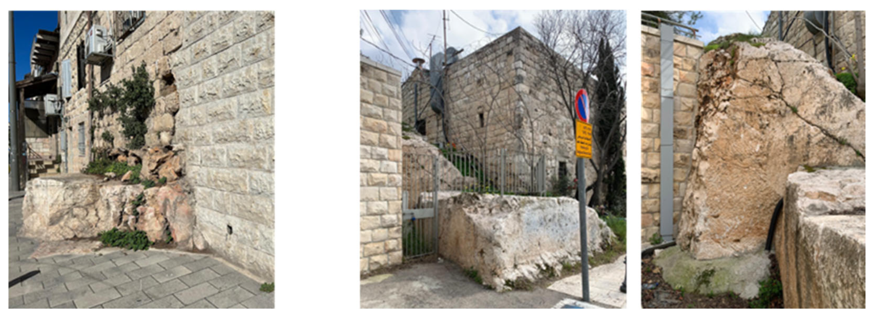
2. Materials and Methods
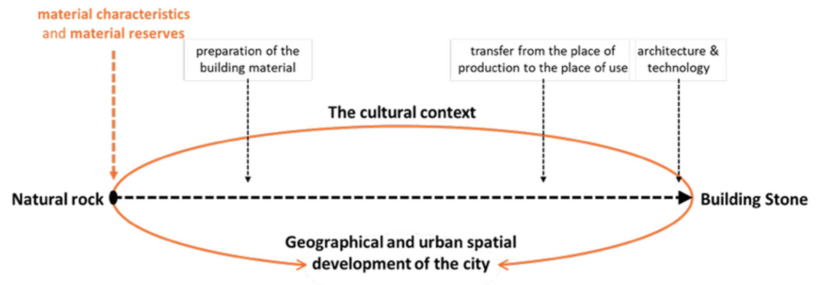
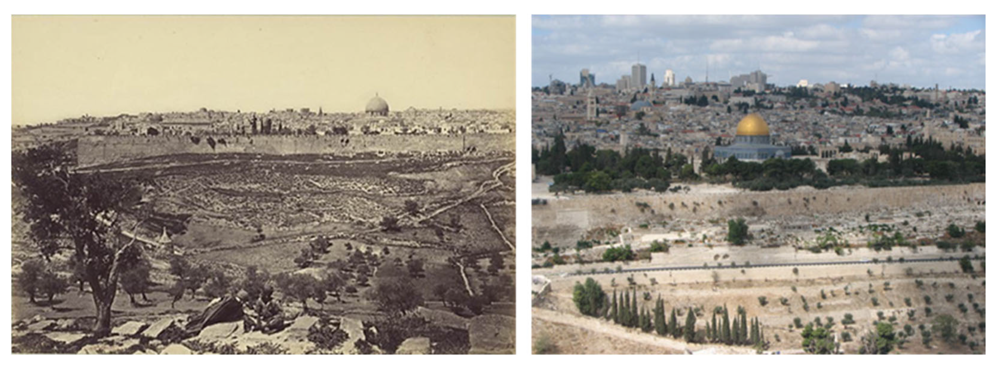
The primary stage of setting the research framework concentrated on (1) defining the urban-geographical area of reference for the study, (2) its time range, and (3) identifying the source of information for retrieving the data relevant to the current study. The urban-geographical area was set to include the area within the city municipal boundaries, i.e., the city of Jerusalem jurisdiction. To expand on previous research regarding Jerusalem’s stone quarries, this study conducted a quantitative and spatial analysis of 39 ancient quarries, drawing on 117 archeological excavation reports from the period between 2012 and 2024. The start year of 2012 coincides with the already existing and available mapped data, presented in Sasson et al. [
29], which discussed quarry and quarries in north Jerusalem during the Second Temple Period; the end date of July 2024 marks when the study was conducted and relevant data published.
The bilingual journal Hadashot Arkheologiyot—Excavations and Surveys in Israel (HA-ESI) served as the primary source. The journal, published since 1961 by the Israel Department of Antiquities and—Museums (IDAM), and since 1990 by the Israel Antiquities Authority (IAA) (originally in print and since 2005 online), contains preliminary reports of all excavations and surveys carried out in Israel, as well as final reports of small-scale excavations and surveys. Unlike monographs on large-scale archeological excavations,
HA-ESI also publishes archeological findings recorded during inspection activities. This open-source, searchable database of archeological reports includes photographs, maps, and plans, as well as figures of small findings and artifacts like pottery and coins. All data are managed and published by the IAA, the governmental authority responsible for enforcing the 1978 Law of Antiquities and regulating all archeological excavations in the country [
31].
Data collection was carried out in several successive steps. Initially, all excavation reports appearing in
HA-ESI on excavations conducted in the Jerusalem jurisdiction between 2012 and July 2024 were individually collected and listed [
32]. This revealed an examination of 117 archeological reports of mostly salvage excavations that were conducted in open areas and built areas prior to development activities within the city’s boundaries during the indicated years. The reports were then sorted using a list of keywords, e.g., quarrying, quarrying or cutting marks, quarry (singular) or quarries (plural), and similar words derived from the same linguistic root. These reports were highlighted as relevant excavation reports for further study. Subsequently, the excavation reports deemed relevant to the study were read in depth to extract both general and detailed data. General data included the title of the report, its date and type, as well as the link to the published electronic report; the name, number, and date of the excavation as well as its type; the excavation location using coordinates (precise) and indicating the area of the city (relative). The detailed data were extracted from the information available in the excavation description and the findings provided by the archeologist. The focus was on specific data related to quarrying or quarries, and the natural rock and the building stone. This was conducted according to defined parameters: quarrying signs, quarry, quarries or indication to a system of quarries, reference to the size of the quarry (small, medium, large, giant) and its type (open, courtyard, shallow, stepped), the dating of the quarry, and wherever mentioned, reference to the lithology or lithostratigraphy where the quarry was open and quarrying work was carried out. In cases where the type of building stone to be produced was mentioned, that was also recorded (
Table 1).
The third stage of the study included quantitative and spatial urban-geographical analysis. The quantitative analysis included general data, the type of excavations that were carried out, and the type of reports published in order to characterize the excavation and the existing information. This analysis determined the scope, type, and the findings regarding the current study’s interest in quarries, quarrying activities, and any information regarding the lithic journey from natural rock to building stone. There were a number of questions asked during this analysis: In how many of the performed excavations were evidence of quarries and quarrying marks discovered? Among them, what are the type of quarries and number of each type? What is the size of each quarry and number of each size? In how many excavations was a system of quarries or quarry infrastructure identified? While the dating of the quarries was also analyzed, this information was less precise in the reports. Further analysis regarding the stratigraphy and lithology aspects, i.e., the type of the natural bedrock and the building stone, was also performed. For example, whether the natural bedrock in which the quarry was opened was mentioned, was the formation and/or the type of rock also mentioned, were the characteristics of the rock mentioned in regard to work of quarrying, was the size of the building stone produced mentioned, and could evidence of their extraction still be seen?
From this quantitative data, a spatial urban-geographical analysis was performed. The guiding questions included: What size and what type of quarries were found in each area of the city? In which area of Jerusalem are the large and giant quarries concentrated? In which area is a system of quarries believed to exist? In what type of quarries were evidence of stone detachment found? What was the size of the building stones that were removed from the quarries where evidence of stone detachment was found? While the quantitative analysis referred only to the new data collected as part of the current study, the spatial urban-geographical analysis combined the data from the current study with available existing mapping data from the previous information layer. For this purpose, the existing 2011 map from Sasson et al. [
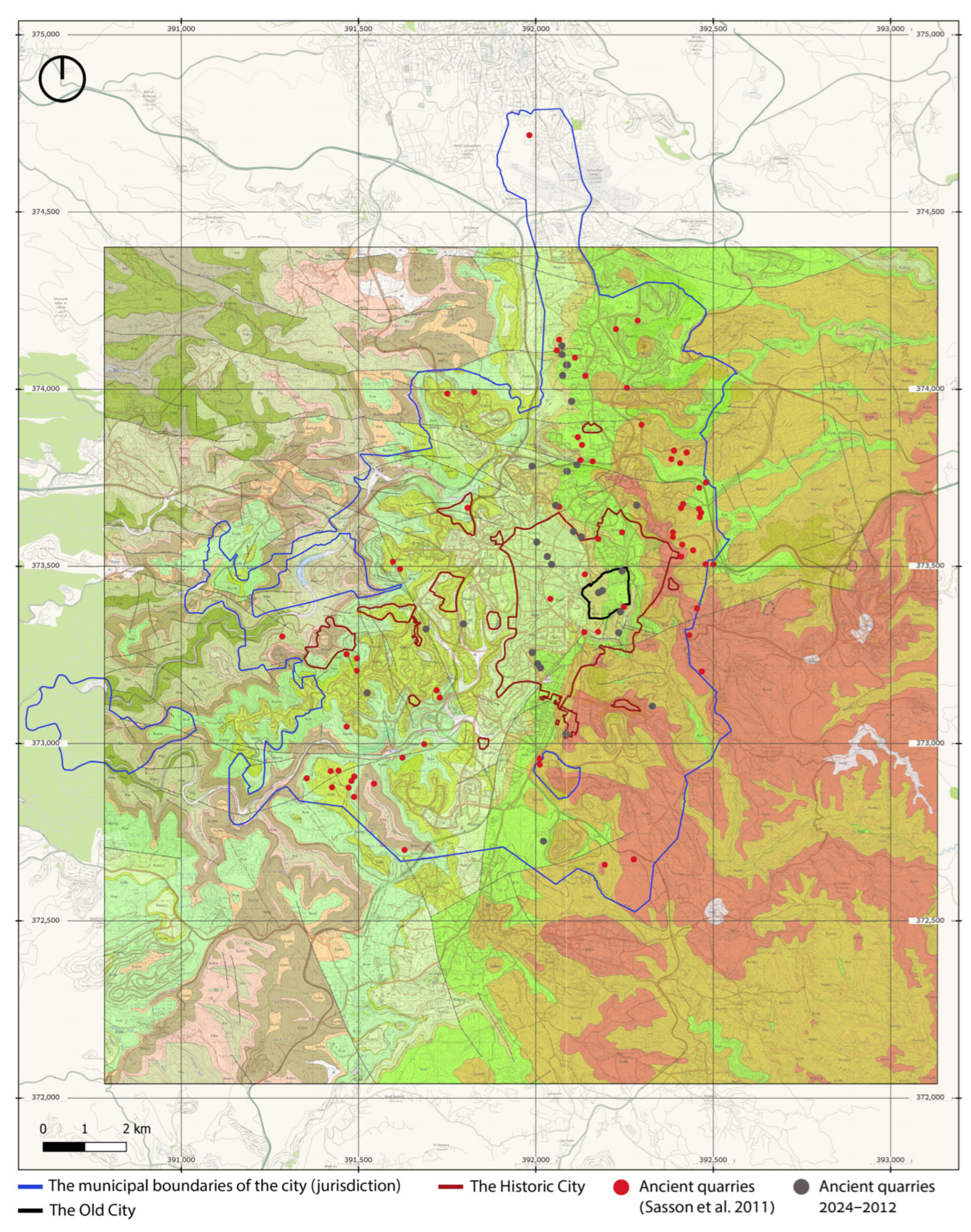
29] presenting relevant data of ancient quarries from the Second Temple period (Late Hellenistic–Early Roman, 2nd century BCE–70 CE) was used as the first layer of mapping by digitizing the hard copy of the map. Next, relevant data from the current study was added to expand the map, i.e., all the excavations in Jerusalem where quarries or evidence of quarrying were discovered between 2012 and July 2024, were included. Each data received its own separate layer.
Parallel to this, an integrated map of the area of the city of Jerusalem and its geological characteristics was also created. The main sources used in this process was an updated geological map of Israel [
24] (1:50,000. Sheet 11-II, Jerusalem). Using free and open-source geographic information system (GIS) software (QGIS version 3.36.3-Maidenhead), the data were uploaded on a superimposed city map and geological map and the previous database from 2011 to obtain the spatial layout of the ancient quarries and their location in relation to the city. The result allowed for a spatial urban-geographic analysis of the quarries that relates to the geological aspects of the natural rock layers of the city’s ancient quarries as well as distinguishing between new evidence for ancient quarries alongside the existing evidence from previous studies. Both the quantitative representation and the spatial representation were included to illustrate the phenomenon.
3. Results
The dataset of this study comprised 117 excavation reports published in
HA-ESI covering a period of twelve years from 2012 to July 2024 [
32]. These reports document archeological fieldwork predominantly conducted between 2006 and 2022. A preliminary review identified 39 reports (33.3%) that contained explicit evidence of quarries or quarrying marks. This section presents a detailed analysis of these 39 excavations, focusing on findings pertinent to the scope of this paper.
3.1. Excavation Context
The majority of the reviewed excavations, specifically 32 out of 39 (over 80%), resulted in the publication of a final report. Five were preliminary reports, while one was an extended report and one was of another type. A significant finding is that approximately 75% (29 of 39) of the ancient quarry discoveries occurred during salvage excavations. These excavations are typically conducted by the IAA to mitigate the impact of urban development [
33]. The remaining ten quarry discoveries were made during trial excavations (6), archeological surveys (2), a development survey (1), and an academic excavation (1).
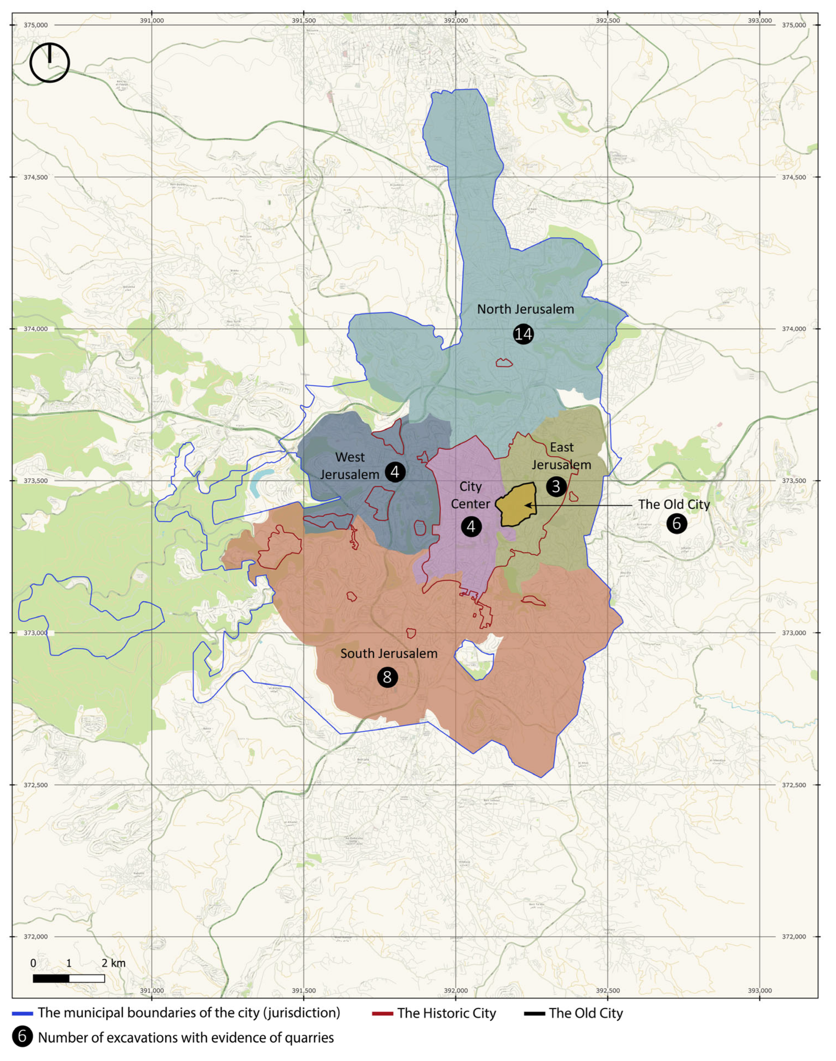
The spatial distribution of the excavations with discoveries of quarries within Jerusalem revealed the following concentration: fourteen (36%) were located in the northern part of the city; eight (20.5%) were in the south; six (15.5%) in the Old City; four (10%) each in the west and city center; and three (8%) in the east (
Figure 6).
3.2. Characterization of Quarries
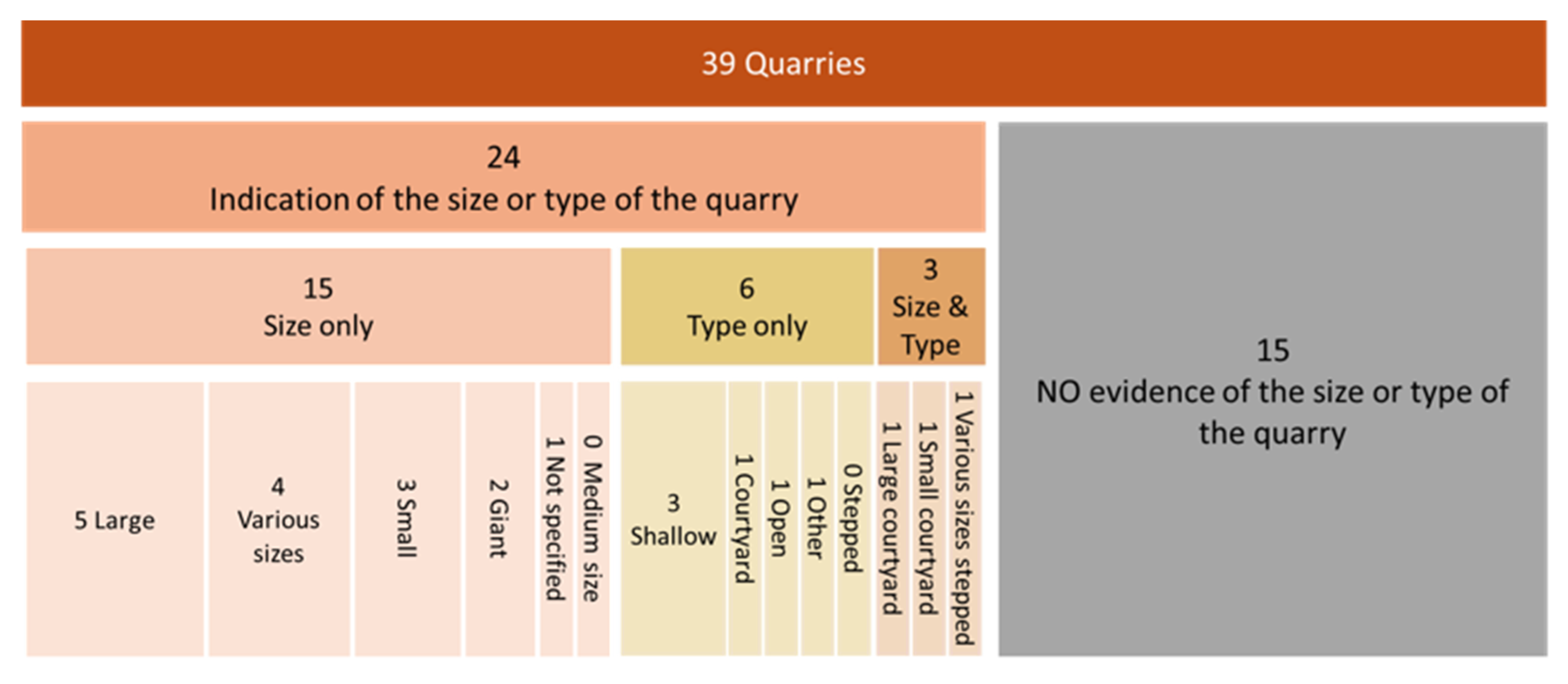
In 24 of the 39 reports (60%), the quarries were characterized by their size, type, or in several cases (3 reports) both in size and type. Quarry size was assessed using relative terms (small, medium, large, giant). Precise dimensions in square meters were rarely provided, and in those cases, the dimensions were estimates due to the partial nature of the excavations. Among the 18 reports that specified size alone or size and type, 44.5% (6 large and 2 giant) described quarries of considerable scale, followed by 28% (5) of quarries in various sizes, 22% (4) of small quarries, and 5.5% (1) of an unknown size due to the fact that it was mostly a trial excavation.
The classification of quarry types drew upon categories established by Safrai and Sasson [
30], with additional information retrieved from the excavation reports, including open, shallow, stepped, and courtyard quarries. Among the nine reports that specified the type of quarry or both the size and type, 33.3% (3) described either a shallow quarry or courtyard quarry of each type, and the remaining three were an open quarry, a stepped quarry, and another type of quarry (ashlar quarry), respectively, which relate to the type of building stone excavated (
Figure 7).
When cross referencing the findings on the size and type of quarries with the urban-geographical distribution according to the areas of the city, it was determined that most of the giant and large quarries (6) were located in northern Jerusalem, with evidence of one giant quarry in the Old City and one big quarry in the city center. Following these were other various-sized quarries also located in the northern part of the city. Small-size quarries were spread throughout the west, east, and south (
Figure 8A). Courtyard quarries (2) were mainly found in the northern area of the city where other types of quarries (stepped and shallow) were also found. In other areas of the city, while no other stepped quarries were found, a courtyard quarry was found in the eastern part of the city, shallow quarries in the city center and the east (one in each), and an open quarry in the southern area (
Figure 8B).
A noteworthy finding is that 21 reports (54%) mentioned the individual quarry as part of a system of quarries, i.e., a larger, interconnected quarrying system (
Figure 8C). Examining the accumulated information of the three characteristics of the quarries—size, type, and connection to a system of quarries—revealed connections between them that are relevant to the previous findings on the urban context and spatial location of the quarries. Specifically, 14 of these quarries (66.6%) were located in the northern part of the city, and among them, 11 were characterized by their size—six (6) large and giant quarries and five (5) quarries of various sizes; two were also characterized by their type, i.e., a large courtyard quarry and a stepped quarry of different sizes; two were only characterized by their type (a courtyard and a shallow quarry); and one was not characterized by its size or type but as part of a larger system of quarries. The remaining seven (7) quarries for which a quarry system was mentioned were located in the east of the city (2) and in the south (2), none of which were characterized as large or giant, rather a small courtyard quarry and an unspecified-size quarry in the east, and a small quarry and an open quarry in the south. In addition, one (1) quarry in each area was mentioned as part of a system of quarries: in the Old City (giant), in the city center (large), and in the west of the city (small) (
Figure 8A–C).
The dating of the quarries was addressed in nearly 80% of the reports (31). Dating was achieved through direct period assignment, relative dating (e.g., “predating a certain period”), or analogical dating based on comparisons with similar, well-dated quarries in the vicinity. Evidence from several reports indicated multi-period use or continuous quarrying from an ancient period into a later one. Modern quarrying, identifiable by modern drilling or blasting marks, was also noted in some cases. The chronological range of the quarrying activity spanned the Iron Age II, Second Temple, Hellenistic, Early Roman, Roman, Late Roman–Early Byzantine, Byzantine, and Early Islamic periods.
3.3. Building Stones
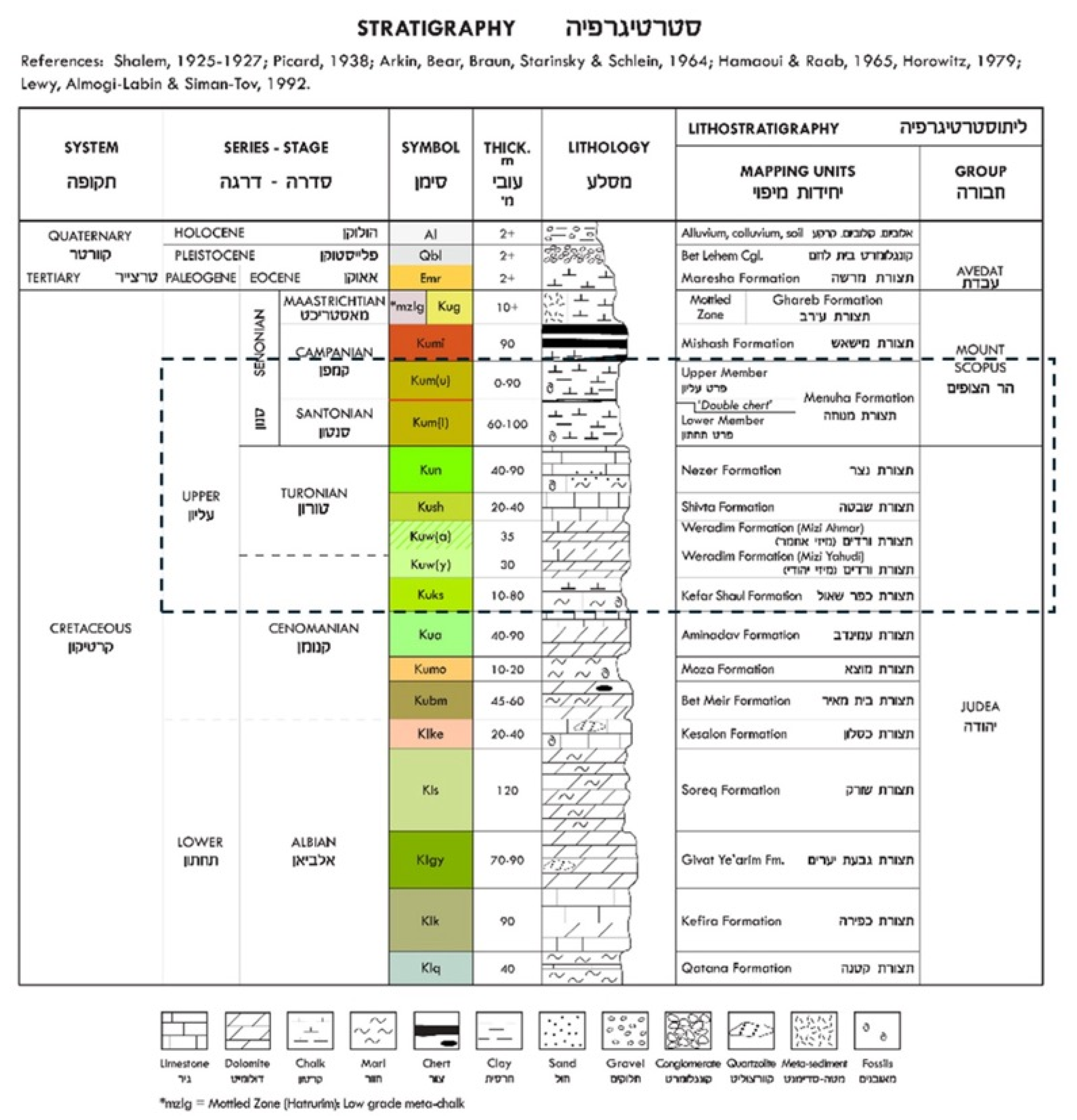
The geological context of the quarries, specifically the bedrock type, was mentioned in 18 reports (46%). The identified rock types were limestone, dolostone (also known as ‘dolomitic rock’, ‘dolomite’, or ‘dolomite rock’), and to a lesser extent chalk and chalk with chert (flint). While all 18 reports listed the type of rock, only seven (7) specified the geological lithostratigraphy indicating the group and formation in addition to the type of rock. Among them, five quarries were opened in the Nezer Formation of the Judea Group and two in the Menuha Formation of the Mount Scopus Group. Both belong to the Upper Cretaceous epoch (100.5–66 Ma), though the first, the Nezer Formation, is in the Turonian series, and the second is in the younger series of the Senonian (according to the old division) or to the Santonian stage (according to the new division) (see
Figure 3). Two of the reports mentioned the traditional common name of the building stone,
Meleke, which is identified with building stone extracted from the Nezer Formation of the Judea Group.
Interesting to note is that in some of the reports, a connection between the natural rock and the quarrying workmanship was made: “the bedrock is a chalky limestone of the Mount Scopus Group—a soft rock, easily quarried” [
34] or “the quarried bedrock layer was soft limestone, ranging in color from white to pale yellow; it is surrounded by cracked and friable layers that restricted the possibility of quarrying” [
35].
Cross referencing the above geological findings regarding the type of the rock with the previously described distribution of the quarries in the urban context and the size of the quarries, it can be noted that among the 18 quarries in which the natural rock type was indicated, eight (8) quarries were located in the north area of the city, five (5) of which were in the Turonian Nezer Formation and one (1) of which is in the Senonian Menuha Formation (for the other two, only the type of the rock is mentioned). Among these quarries, in the north part of the city where the natural rock type is indicated, all eight (8) belonged to a system of quarries and five (5) were of a considerable size (large and giant).
Of the 18 reports, in 10 where the type of the natural rock is mentioned, only two (2) quarries in the eastern part of the city resembled a similar though not identical situation as the quarries in the northern part of the city. They were both from the Senonian Menuha Formation and belonged to a system of quarries, although one is a small quarry, and the size of the other is unknown due to the type of excavation.
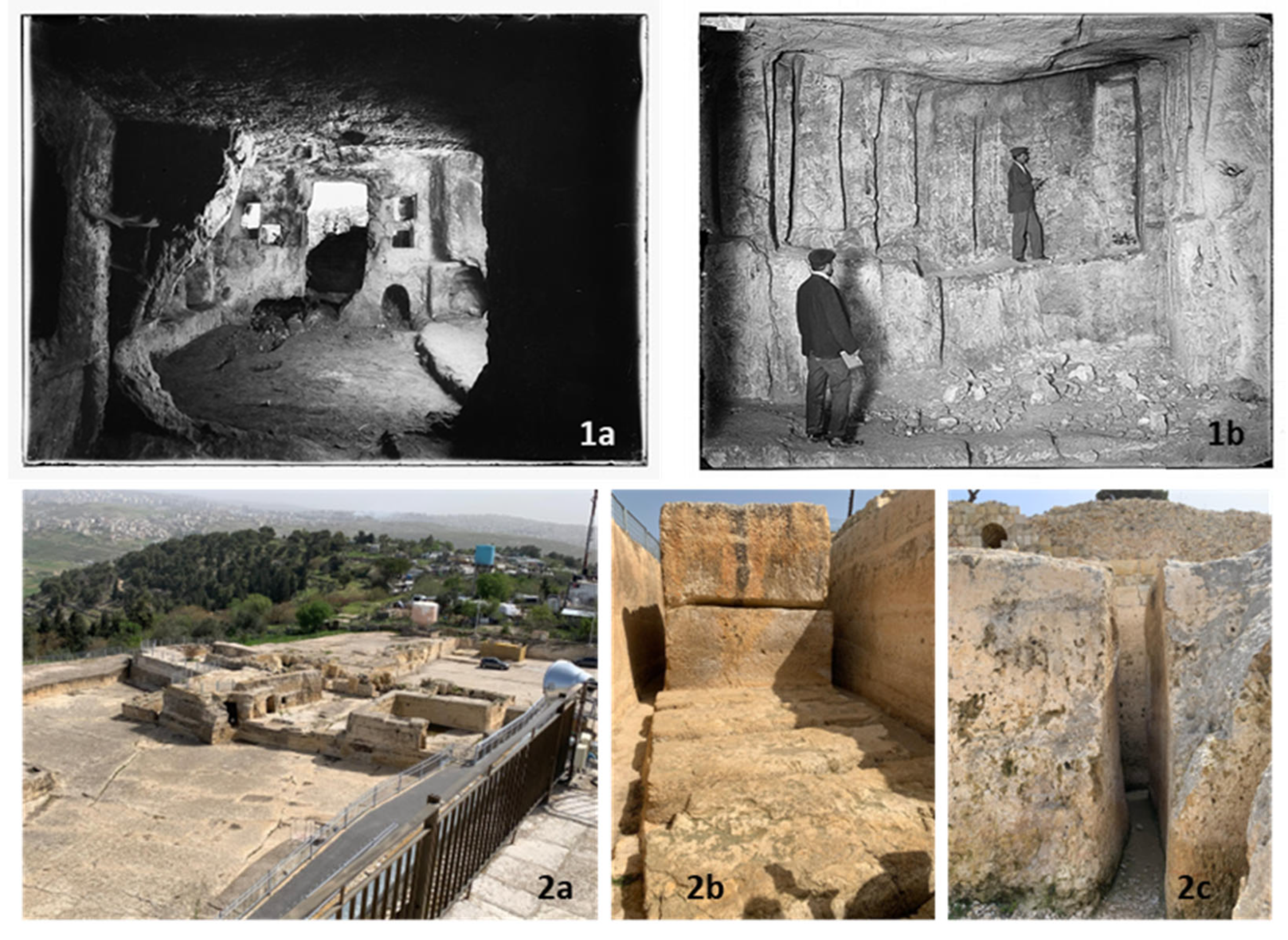
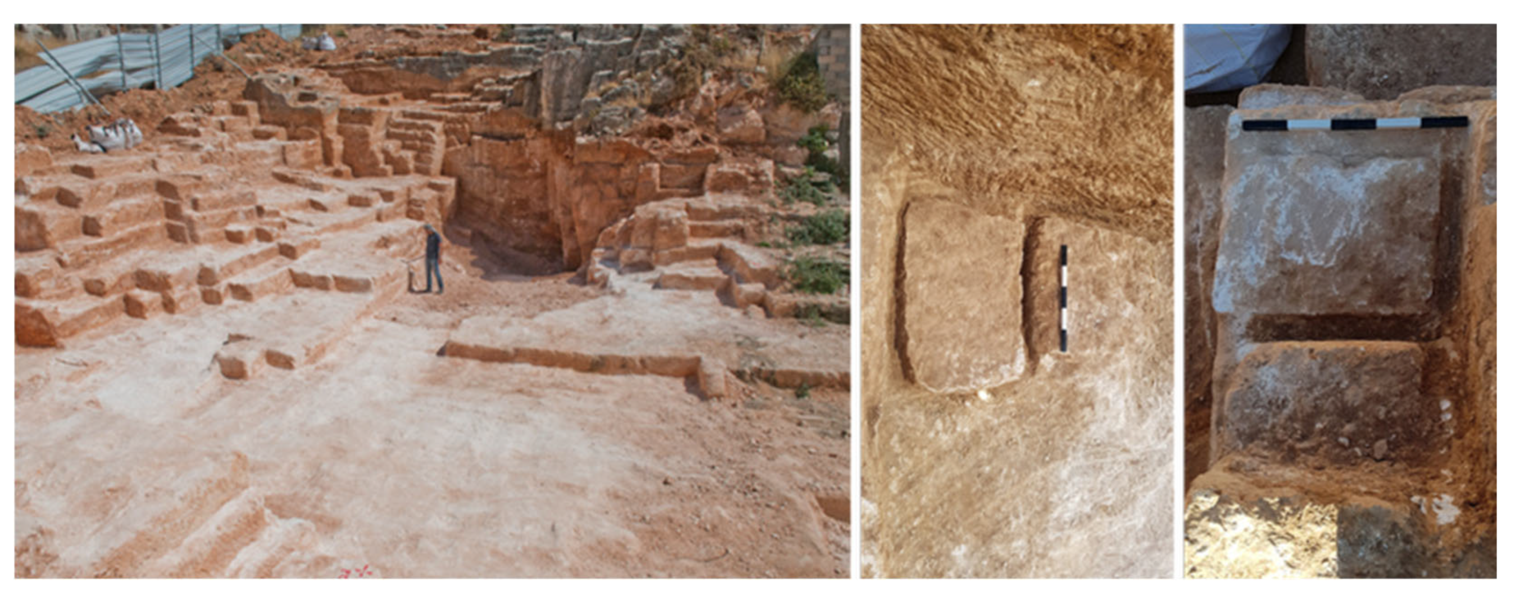
Evidence related to stone extraction was a common theme, with 35 reports (90%) detailing methods such as severance channels, cutting channels, and quarrying and dressing marks. Of these, 24 reports (68.5%) documented partially cut stones that were still attached to the bedrock. The size of the quarried blocks was described in 27 reports (69%), using a relative size like giant, large, medium, and small, and sometimes indicated the specific dimensions of the building stones. A significant finding is that in 18 of these 27 reports (67%), evidence of extracting multiple stone sizes from a single quarry was observed (
Figure 9). The subsequent use of the quarried stone was mentioned in 15 reports (38.5%), with some mentioning the supplying of building stones to Jerusalem buildings for an extensive time. Of these, four (27%) reports indicated that the stones were used for construction at or in close proximity to the quarry site (
Table 2).
4. Discussion
The findings from this quantitative and spatial analysis of 39 ancient quarries, drawing on 117 archeological excavation reports, provide compelling evidence that supports and expands upon previous research providing a broad and updated database on ancient quarries within the city of Jerusalem boundaries and their main characteristics as well as accumulated spatial mapping.
The results of the current study confirm the conclusions of Sasson et al. [
29]. It strongly supports a main finding regarding the spatial urban-geographical distribution of a high concentration of ancient quarries in northern Jerusalem during the Second Temple period as well as their geological settings, as presented in the integrated map below (
Figure 10). However, in relation to the historical scope, this study broadens the dataset and demonstrates that this phenomenon is not confined to a single period but is a longstanding characteristic of the city’s quarrying industry.
The notable concentration of large-scale quarries in the northern part of Jerusalem can be attributed to a confluence of geological, geographical, and logistical factors. As our spatial analysis shows, these quarries were predominantly located in the Turonian bedrock of the Netzer Formation (formerly Bina) of the Judea Group. This specific geological layer, known for its high-quality building stone, provided a readily accessible resource for ancient quarry and building works. In this regard, the current study used archeological reports as “raw materials” to extract geological data pertaining to ancient stone quarries. Therefore, two key recommendations that can be drawn from it are: (1) any excavation report detailing an ancient quarry must include stratigraphy data, i.e., the geological layer, as a mandatory data; and (2) the archeological excavation should include comprehensive material analysis of natural bedrock based on rock sampling and laboratory work using analytical methods to provide the mineralogical and petrographic characteristics of the quarry’s rock. For large or multi-level quarries, the entire area of the quarry should be marked on the Geological Map of Jerusalem to examine the geological extent of the quarry, and multiple rock samples should be systematically collected to ensure representative analytical coverage.
Furthermore, the strategic location on a north–south ridge facilitated the efficient transport of material to the city, aligning with hypotheses regarding the topographical advantages of these sites. The integrated mapping already emphasizes the connection between the geographical location of the quarries and their relative altitude to the city and the subsequent transportation of building stone to Jerusalem. While this supports the assumption of the existence of an organized site for transport and the proximity of these quarries to known ancient routes, identified either during the excavation itself or through prior archeological surveys in the adjacent areas [
37,
38], this aspect can be further emphasized by integrating a layer of ancient and historic routes—sourced from historical maps, such as the Palestine Exploration Fund (PEF)—into the GIS mapping. This integration facilitates the spatial examination of the relationship between precise, archeologically derived quarry locations and the routes and field evidence of the mapped roads.
The quantitative findings from the excavation reports provide insights into the characteristics of the ancient quarries mainly in terms of their size, type, and whether they belong to a system of quarries. The findings also highlight a clear distinction between the quarries in northern Jerusalem and those found in other parts of the city. While smaller, more sporadic quarries exist throughout Jerusalem, the northern sites are characterized by their significant size and the production of large building stones. The consistent evidence of multi-level, complex quarries—including courtyard, open, and stepped varieties—in the northern areas further supports the hypothesis of a centrally managed, large-scale industry, likely state-run, as previously suggested by Safrai and Sasson [
30] and Sasson et al. [
29]. This contrasts with other areas where quarries appear to be smaller, more private ventures.
These reports offered rich descriptions of specific quarry characteristics, including the quarry levels (from two levels to a multi-leveled quarry), preserved high rock walls in the quarry perimeter, and detailed descriptions of quarry steps along with exact dimensions. Additionally, some of these reports provided information on evidence on the operational workflow, noting the directionality of quarrying [
36,
39,
40]. In addition, and not specifically addressed before, it draws upon the connection between the source of rock, the type of quarry, and the extracted building stone. In this respect, the current study facilitates future material conservation research focused on data collection regarding the decay of various building stones in both ancient and historic structures, thereby expanding upon the analytical methods previously suggested for identifying the quarried material of the natural rock. Furthermore, the findings of the current study reveal a direct correlation between the discovery of ancient quarries and modern urban planning initiatives. The fact that 75% of the quarries in this study were uncovered during salvage excavations demonstrates that the expansion of contemporary Jerusalem reveals a wealth of archeological information. In the context of the spatial distribution of quarries around Jerusalem, Yeger [
41] offers an interesting hypothesis: the scarcity of finds east of the Old City can be attributed to the fact that intensive development of the area occurred before any archeological excavation could be performed. This link underscores the importance of integrating archeological research into urban development, as the city’s growth continues to uncover its ancient industrial and material history. The methods in this study provide the blueprint for integrating the two fields in such a way that any new construction provides an opportunity to expand the archeological data about Jerusalem’s development. Recognizing the relationship between rapid, intensive urban development and the discovery of quarries within city boundaries profoundly impacts urban heritage management. For example, it may be necessary to mandate that archeological surveys and excavations be conducted at an earlier stage of the planning and development process to ensure the timely extraction of crucial archeological and historical information. The goal is to shift the majority of fieldwork from reactive salvage excavations—like those examined in this study—to proactive, planned excavations.
The detailed excavation reports noted two additional phenomena concerning the secondary use of abandoned quarries. While these were not the primary focus of this study, their significance warrants future investigation. One is rock-hewn burial caves and chambers in the quarry walls, which were mentioned in earlier studies. The second is soil accumulation within the quarry areas that converted the former quarries into agricultural terraces, indicating an integration of these sites into the agricultural hinterland of Jerusalem after their primary use had ended, which was briefly indicated by Sasson et al. [
29] but received a specific focus in recent studies such as Yeger [
41], who focused on archeological excavations mainly in the north part of the city. Both of these phenomena can be explored using the methodology employed in this study.
The methodology of the current study, based on a growing database of excavation reports, offers a new approach to the study of ancient quarrying. The framework allows for the continuous integration of new data, providing a dynamic research tool that can be refined over time. For example, future research could incorporate data on quarry altitude to more precisely model transportation logistics, or the quarry location on a specific slope of the mountain, factors identified as significant by Sasson et al. [
29]. Moreover, the methodology used in this research suggests that GIS tools allow for future examination of the direct relationship between the discovery of ancient quarries and ancient spatial infrastructure and modern urban planning initiatives. This study reveals that the majority of ancient quarries (75%) were found during salvage excavations, which are a prerequisite for urban development. To further illustrate this connection, an additional GIS layer is proposed. This layer would integrate data on designated construction and development areas in Jerusalem from the master plan and other approved projects. This integration would provide a comprehensive spatial analysis of the interplay between archeological findings and urban development.
As noted by Safrai and Sasson, Sasson et al., and currently by Mamalya and Ben-Yosef [
29,
30,
42], while approximately 80% of the excavated quarries in the region are within carbonate sedimentary rocks (limestone, dolostone, and chalk) there is a methodological complexity in studying stone quarries. Part of it is the dating of ancient quarries, which remains a significant challenge due to the absence of sealed levels, the lack of in situ artifacts, and the long-term consistency of traditional quarrying technologies. Consequently, the dating of these sites often relies on circumstantial evidence from nearby settlements. Future research could explore advanced dating techniques or focus on integrating historical and archeological data more closely to address this limitation.
The subject of ancient quarrying in Jerusalem is a broad topic that invites new discoveries in historical, archeological, and geological research. While it can be broadened to the exploration of regional and worldwide phenomena, the current research explicitly focused on the city of Jerusalem, which is in line with a continuing research trend. Interest from researchers grows, however, as evidenced by the recent symposium at the National Institute of Archeology of the Land of Israel in Jerusalem entitled “Ancient Stone Quarries: the Local Aspect” [
43], which addressed quarries and stone tools, the importing of stones and their transportation methods, as well as the connections between stone quarries, construction, and agriculture. It is evident that the great attraction to these subjects of quarrying and quarries in the context of the city of Jerusalem stems both from the city’s large construction projects and from the appearance and image of the city itself, whose prominent material character is intimately related to the surrounding landscape.
The current study, which focused on new evidence for ancient quarries within the city of Jerusalem, adds another “layer of stone” to this field of research, which is part of the framework of “geo-archeological studies,” and the study of human–environment interactions [
42]. Furthermore, this multidisciplinary research builds upon existing research to introduce the urban-geographical aspect of the spatial dimension of the city and its surroundings with potential urban heritage and heritage management contribution. This is especially important as the city continues to develop, and new excavations are undertaken.
