Article

“Scouring for Prehistory”—An Opportunistic Methodology for Sea Floor Archaeology

by
Ervan G. Garrison
1,2,*,
Emily Carter Jones
1,2,
Michael Robinson
3,
Yasmine I. Rivera
4,
Kelsey A. Williams
4,
Benjamin Prueitt
3,
Anderson L. Carter
5,
Matthew A. Newton
6 and
C. Andrew Hemmings
7
1
Department of Geology, University of Georgia, Athens, GA 30602, USA
2
Department of Anthropology, University of Georgia, Athens, GA 30602, USA
3
Skidaway Institute of Oceanography, University of Georgia, Savannah, GA 31411, USA
4
Geoarchaeology Laboratory, University of Georgia, Athens, GA 30602, USA
5
Department of Science and Engineering, University of Groningen, P.O. Box 72, 9700 AB Groningen, The Netherlands
6
Department of Anthropology, University of Florida, Gainesville, FL 32611, USA
7
Aucilla Research Institute, Monticello, FL 32344, USA
*
Author to whom correspondence should be addressed.
Heritage 2024, 7(7), 3417-3428; https://doi.org/10.3390/heritage7070161
Submission received: 14 May 2024 / Revised: 7 June 2024 / Accepted: 13 June 2024 / Published: 26 June 2024

Abstract

Finding prehistoric sites, on the sea floor off the United States, has proven to be a difficult task. Over four decades of innovative attempts have produced few discoveries. This discussion outlines the difficulties in finding submerged prehistory on the sea floor, examines current methodology(ies), and presents a new methodology that demonstrates promise based on research conducted over the past decade. The purpose of this discussion is to outline the problems facing archaeologists searching the sea floor for archaeological sites. It is less of a critique of past efforts and methodologies used in those attempts. Without those efforts, a reason for developing a different methodological approach would be unnecessary. Any “one size fits all” methodology is limiting, and the scant number of marine archaeological sites located off the shores of the United States can attest to the need for practitioners to continue refining their methods. This is especially the case on the continental shelf of the eastern United States, where sediment cover is often meters, or several meters, thick. This opportunistic methodology developed on the continental shelf of the Georgia Bight, western Atlantic Ocean, has located intact paleo-landforms with in situ, palaeoecological remains thereby offering promise for future archaeological discoveries.

1. Introduction

The Problem

Prehistory on submerged coastal plains is difficult to locate. This simple fact has been demonstrated by the results of well-designed and carefully executed studies that have failed to find and characterize archaeological sites on the U.S. continental shelves [1,2,3,4,5] Potential archaeological sites were subsequently identified by parameters defined in their predictive model. While this and subsequent studies [4,5,6] have focused on the individual regionality of their study areas, the objectives and methods were multi-regional in both scope and applicability. Acoustical geophysical methods are the standard method of choice to locate underwater prehistoric sites. Sediment cores are subsequently collected using a 12 m pneumatically driven vibracorer. The recovered cores are split, photographed, and logged. Samples are then extracted for grain size, point count, palynological, foraminiferal, geochemical, and Carbon-14 analyses. While researchers, including this first author, have enthusiastically embraced this methodology outlined and demonstrated by Gagliano et al. and Pearson et al. [1,2,3] to characterize and evaluate submerged prehistoric landscapes, this seminal attempt only produced equivocal evidence for prehistoric deposits. This was proven to be the case in another well-executed study in the northern Gulf of Mexico [1]. Nonetheless, as a model for site discovery, later studies have opted to utilize an analogous approach [6,7,8,9]. One key difficulty in locating prehistory on the sea floor, paraphrasing Flatman and Evans [10], is scale, noting that materials such as worked stone, fragments of bone, wood, or arrangements of these items within sites (hearths, drive lines, huts, shelters, etc.) are invisible to almost all acoustical or other geophysical instruments in use today. Size is likewise a factor for sediment coring. Crombé and Verhegge [11] published an excellent article comparing the effectiveness of sediment coring for the detection of deeply buried Paleolithic-Mesolithic hunter-gatherer sites in the Netherlands and Belgium. These types of sites are analogous in size and depth to the Archaic Period sites in the Southeastern U.S. Crombé and Verhegge’s study was actualistic, that is, it utilized data from 11 archaeological sites that had been cored using a variety of barrel diameters, grid sizes, and sieve sizes to determine how any combination of these parameters optimized actual site discovery. In their study, they used core barrel diameters of 7, 10, 12, and 15 cm. The 7 cm diameter core barrel best approximates the 3-inch pipe diameter. They used four (wet) sieve sizes of 1–4 mm. The average number of cores taken at the 11 sites was 64. Their grid intervals were 5, 10, 15, 20, and 30 m. Their discovery rates on a majority of sites sampled (8/11) averaged between 5 and 22. The 10 cm diameter had an increase in positive recovery over the 7 cm diameter barrel of 18.4%. Increasing the barrel diameter to 12 and 15 cm resulted in an increase in recovery of materials with a 37% gain from 12 to 15 cm, the largest barrel size. Their findings demonstrated that grid intervals of 10 m or less using 10/12 cm auger diameters optimized both time and recovery. In other words, 5 m is best, 10 m is good, and 15–30 m intervals are not recommended.
Taken together, the studies of both [2,3] recovered 106 sediment cores, ranging from 6 to 12 m in length, and all approximately 10 cm (4 in) in diameter. Those cores represented a surface area of approximately 3.4 m2 across the entire northwestern Gulf of Mexico continental shelf whose area exceeds 46,538,848 hectares (115 million acres). Using the state of Louisiana’s guidelines for terrestrial archaeological survey as a comparison, a standard 30 cm diameter shovel test covers a surface area of approximately 0.07 m2, so the cores represent the equivalent of 12 shovel tests [12]. While the sampling interval for cores varied, Pearson et al. took ten cores, in lease block 6, at separations between 15 and 30 m (50–100 ft). Recalling Crombe and Verhegge, coring intervals greater than 10 m have increasingly diminished results. Although more than 11,000 Clovis points have been reported [13,14,15], Clovis sites are rarely large, and most appear to have been briefly occupied and only a few square meters in size. Size matters.
Another factor to be considered is the density of prehistoric sites on the continental shelves. Stanford et al. [16] estimated the Clovis shoreline at about 50–55 m below modern sea level in the Delmarva Peninsula. On the continental shelf from Virginia to Texas, called the Southeastern Continental Shelf (SECS), 446,786 km2 of the continental shelf was dry land at the LGM and 350,376 km2 was dry at Clovis times (13,300 yr cal BP). Thus, an area about the size of Alabama, Georgia, and Florida combined could have been occupied by pre-Clovis peoples. In the Gulf of Mexico, pre-Clovis shoreline and brackish water estuaries were identified at −76 m on Pulley Ridge in Southwest Florida and off the Mississippi and Alabama coasts at −73 m [17]
To estimate the Archaic Period site density, Cook Hale and Garrison [18] focused on sites from the Early and Middle Archaic periods (11,500 yr cal BP–8900 yr cal BP and 8900 yr cal BP–5800 yr cal BP). These correlate to the Early and Middle Holocene, and there is ample evidence for intermittent occupational discontinuity and cultural hiatus throughout the southeastern United States during these periods. Archaeological settlement patterns for some submerged coastal zones from the earliest periods examined here cannot be directly detected, but if environmental conditions played a role in changes in foraging systems and associated settlement patterns, these effects should coincide with analyses of interior regions [19].
Cook Hale and Garrison used data for the Early and Middle Archaic (early to middle Holocene) sites taken from Georgia and Florida Master Site Files for locations below the Fall Line, where the coastal plain begins. The reasoning presumed that site distributions for the now drowned coastal plain should be similar to that of the subaerial plain [17]. Their study concluded that a straightforward predictive model for Early Archaic or Middle Archaic sites in the offshore zone in the southeastern United States cannot be constructed from simple physiographic and paleoecological data. Some site correlations, such as the Early Archaic upper coastal plain sites, were untethered from any resource such as higher net primary ecological productivity (NPP) or access to tool stone outcrops. Some Middle Archaic coastal sites were only predicted by access to the coastline, which is simply a tautological finding.
Prehistoric sites do exist on the continental shelf. This was aptly demonstrated in 2016 when an amateur diver first reported possible human remains in the waters just off Manasota Key to the Bureau of Archaeological Research (BAR) [20]. Through non-invasive underwater survey and investigation techniques, including magnetometry, sub-bottom profiling, and side-scan sonar, BAR’s underwater archaeologists soon documented evidence of a prehistoric Native American burial site in a freshwater peat-bottomed pond used in the Late Archaic Period. The radiocarbon dating of two stakes from the site were dated to more than 7200 years old [21]. The site joins other well-documented Archaic Period pond burial sites, including the well-known Windover site in Titusville and Little Salt Spring in Sarasota County.
Serendipity is great, but it is not a reliable methodology for locating and studying submerged prehistoric sites.
Since 1993, the University of Georgia faculty and students have carried out archaeological surveys at Gray’s National Marine Sanctuary (hereafter Gray’s Reef) (Figure 1). Those surveys were performed on an annual basis until 2013 and recovered Pleistocene and Early Holocene terrestrial mammal remains of horse, bison, camel, and large vertebrate post-skeletal bones as yet unidentified. Three putative stone and bone (antler) artifacts were found in the vicinity of the faunal remains. Large numbers of oysters were likewise recovered indicating an estuarine phase for the location during past sea level transitions [22]. Unlike the in-situ Manasota Key (Florida) Offshore site [20], an Archaic pond cemetery, the Gray’s Reef discoveries were made scattered at or near the present-day sea floor. The sediments were those of the geologically modern palimpsest sediment cover of today’s inner-to-mid-continental shelf [23,24], and thereby time-transgressive in nature.

2. An Opportunistic Methodology—Scour Nuclei

Enter serendipity—again. In 2006, during diving surveys in and around Gray’s Reef, the hull of a World War II Liberty Ship, A.B. Daniels, was visited more as a distraction than as part of the actual survey (Figure 1). This ship was placed on the sea floor as one of numerous artificial reefs created on the continental shelf off Georgia. These artificial reefs are fish havens and provide habitat and cover for recreational fish species. What was discovered at the site led to the formulation of a different methodological approach to prospecting for prehistoric landforms and sites.

2.1. Scour Nuclei

The presence of an object on the seabed produces local flow acceleration or turbulence due to continuity and drives a flux of local sediment and concomitant bed adjustments [25]. Niedorada and Dalton [26] address the processes of scouring beginning with the concept of boundary layer flow and sediment dynamics [27]. Scour is the morphodynamic response to the presence of an obstruction on the seabed. These scour processes and the features they create are multiregional and supralocal. Scour is important for a variety of marine situations including bridge piers, dock pilings, breakwaters, oil platforms, offshore pipelines, marine artifacts, heterogeneous seabed bedforms, and naval mines [25] While scour varies from locality to locality, it is a universal aspect of current flow.
Numerous modern studies of scour have been carried out by researchers with archaeology prominent (Quinn; various [28,29,30,31,32]). Scour forms from turbulent flow which is characterized by the formation of vortices—horseshoe and wake [25,26]. The former are located at the incident margin and sides of an object while the latter form in the “lee” or rear (supra). Erosional depressions created by turbulent flow are referred to as “moats” and “comets” by Raineault [33]. These designations are not exclusive, and a moat can form adjacent to a structure and subsequently extend away from the structure forming a tail much like a comet. Smyth and Quinn have differentiated these as near-field and far-field scour features [34]. Raineault et al. [33] located comets in the lee of nucleating objects.
The overall dimensions of erosional features are determined, in large part, by size [25,28,29,30,31,32,35], The size of a comet can approach that of the nucleating object [28,32,36,37,38]. These various studies have shown the principal factors acting in scouring are size, orientation, current velocity, and sediment type. Larger objects and higher current velocity produce deeper and more extensive scour. Orientation can determine the overall shape and extent of scour features, while different sediment types can impede or enable scour. One additional factor is that of time. The longer the time an object is exposed to scouring flow, the more expansive the erosional features. Trembanis [38] noted that an equilibrium between scour and the settling of the object into a sediment matrix is reached at some period after the onset of scour. In the Georgia Bight, tidal currents observed at the Liberty Ship are strongest on the ebb tide with velocities of 30 cm−1s on average.

2.2. Scour as a Tool for the Study of Submerged Prehistory

The scour at the Liberty Ship site has removed Holocene and late Pleistocene sediment strata to depths of over 3 m (Figure 2). Through this process, paleontological deposits formed in the moat immediately adjacent to the ship. These deposits contained both vertebrate and invertebrate fossil elements eroded from the strata. While no archaeological finds were present, had they been, they would have been deposited in the scour feature. The amount and density of the deposits was directly correlated to the depth and extent of erosion.
Archaeological and paleontological materials found at the Gray’s Reef National Marine Sanctuary, located approximately 16 km south of the Liberty Ship site, are the direct result of scour. Geological outcrops have eroded sediments such that both paleontological and archaeological finds have been made [22]. Gray’s Reef is not a coral structure. It is a series of stone outcrops that extend roughly along the −20 m isobath in the Georgia Bight. These outcrops nucleate scour and have eroded the sediments once covering them. It is from those sediments that both faunal and archaeological materials have been eroded and redeposited below the ledges at Gray’s Reef.
The effectiveness of scour in removing extensive sea floor sediment cover suggested it as a tool for the discovery of prehistoric facies previously buried.

3. A Study of Artificial Reefs as Scour Nuclei

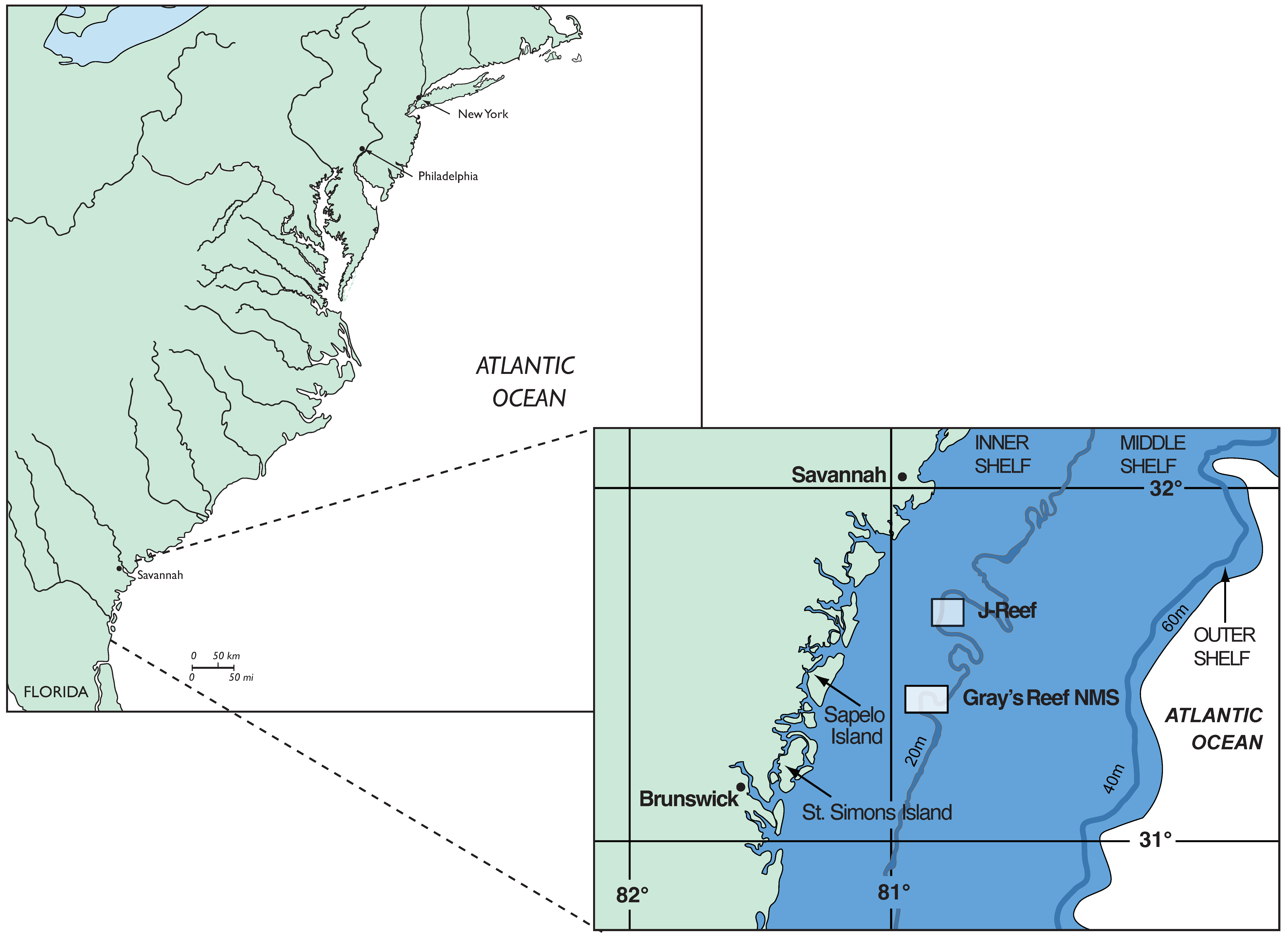
3.1. The Northern Tier, 2020–2023

The Liberty Ship where scour features were observed in 2006, is only one of several artificial reefs. With funding adequate for the task, UGA embarked on the characterization and exploration of scour nuclei.
Eight sites were chosen among the artificial reefs created since the 1970s by the Georgia Department of Natural Resources (GaDNR). Figure 3 is a map of the artificial reefs at the northern portion of the Georgia Bight offshore of Georgia. The eight sites were chosen based on both their proximity to UGA’s Skidaway Institute of Oceanography, which greatly facilitated access together with the nature of the sites—their size and the duration of their exposure to scour, in many cases, greater than three decades. In fact, the GaDNR artificial reef locale where the Liberty Ship is first located—JY Reef—was the southernmost site visited during our study.

3.2. An Innovative Methodology

Our methodological approach consisted of the following five steps:
  • Evaluation of archival information. This step includes geophysical, geological, archaeological data available. Select sites for step 2.
  • Geophysical survey of selected sites. In our case, the use of interferometric side-scan sonar (SSS) was prioritized with some follow-on sub-bottom profiling (SBP) conducted on sites selected for ROV and diver survey.
  • Process all geophysical data using software such as HYPACK Survey 2022; Geophysics 2.0; Office SonarWiz 6, etc.
  • Produce both individual scour nuclei sonograms along with mosaics of reef sites.
  • Generate digital bathymetric models (DBM) of scour features by use of Geographic Information System (GIS) software (Arc GIS 10.8.x, Q GIS 3.34, etc.).
  • Survey and evaluate selected scour nuclei—based in DBM analyses—using remotely operated vehicles (ROVs), divers, as well as sediment corers (gravity, box corers) and grab samplers.
This approach diverges from earlier and present-day studies in its emphasis on the examination of sea floor exposures created by turbulence-induced scouring. Geophysical and sediment sampling studies are used, but our approach differs in the reduced reliance on sub-seafloor imaging choosing to focus, instead, on exposed sea floor. Likewise, our use of sediment sampling is more to characterize the exposed sea floor than to penetrate it. We rely on turbulent flow and scour to do that. The emphasis is on “surficial” rather than “buried”. Additionally, our approach emphasizes the mapping and bathymetric modeling of the moats and comets before survey and sampling are conducted.
Figure 4 is an example of a DBM generated from side-scan sonar data. Swath bathymetry and side-scan sonar data were collected with a 230 kHz Edgetech 4600 interferometric side-scan sonar and topside processor, providing co-registered simultaneous side scan and bathymetric data. It is site Reef SAV. Reef SAV is the GaDNR designation for the locale. We cannot claim originality for this step. The “fusion” of instrumentally derived data, specifically sonar, and GIS analysis was previously discussed by Sonnenburg and Boyce [39]. Their study sought to discover and characterize submerged prehistoric landscapes and detect archaeological sites in a systematic bathymetric and side-scan sonar survey of Colonel-By-Lake, Ontario, Canada. As Figure 4 shows, both the areal extent and the depth of scour features were measured and used to select sites for detailed investigation.
Our initial on-site investigation combined an ROV survey followed by sediment sampling of comet features. Ground-truth study was first investigated using a Blue Robotics BlueROV2 vehicle configured as “heavy” with eight thrusters. This configuration allows for greater maneuverability in currents typical of the continental shelf. The vehicle has two video imaging modes—a low-light high definition (HD) onboard camera for navigation and steering and a 4 K HD camera mounted on the vehicle’s frame.
Moats form directly adjacent to the scour nuclei. While deeper than comets, these features do not extend far from the object. Small ROVs have proven to be useful in the study of scour nuclei’s erosional features. ROVs are recording platforms that provide real-time visual data and recorded data. An ROV requires only power—onboard or external. In our study, we used an ROV that used internal battery power for dives averaging 30–45 min. Multiple batteries guarantee multiple dives per study site.
After ROV inspection, the primary tool used was PONAR sediment grab samplers which are easily deployed from small research vessels. This is an important point. Smaller vessels are less costly than platforms typically utilized by other studies. Research vessels are expensive. An approach that can use smaller, less-costly vehicles and deploy instruments/samplers without extensive deck handling gear has merit. Sediment coring using drop/gravity corers were not successful in the Georgia Bight, particularly in comet areas where intact/compact soils or sediments were exposed. The majority of sediment samples were taken from small vessels using grab samplers which had difficulty in collecting sediments with high proportions of clastic sediments, although adequate sampling of a site was achieved with persistence. Five kilograms of sediment recovered at a site was considered minimal and, in most cases, more material was recovered with a dozen or more grabs. Still, smaller vessels are not always an option. We were fortunate to have access to the University of Georgia’s Skidaway Institute of Oceanography research ship SAVANNAH for a one-day instructional cruise. We deployed a 0.5 m box coring system retrieving three sediment samples in excess of 20 kg each at Reefs SAV and KC. Box cores have the added benefit of preserving sediment stratigraphy. When the on-site and subsequent laboratory analyses of video and sediments were completed, sites were selected for diver survey.

3.3. Reef SAV, Barge 13, Discovery of a Late Pleistocene Landform

First surveyed in 2018, this reef site is the northernmost site studied. The reef site contains numerous structures such as the three steel barges shown in Figure 5. Two of these barges were extensively surveyed—Barges 6 and 13. We were able to use box coring at Barge 6 deployed from the RV SAVANNAH, which has the capacity to deploy this type of sediment retrieval system. Barge 13 was sampled using grabs as well as the excavation samples retrieved by divers. The divers recovered sediment samples from moat areas previously inaccessible by grabs or coring.
Barge 13 proved to be a confirmatory example for our methodology. An intact 37,000–40,000-year-old landform was exposed in both the moat and comet scour that was produced. On this landform, divers found in situ trees and fossil bone. Without direct dating of the bone, the age was presumed to be chronologically that of the trees. Barge 13 tree ages were determined from in situ trees found at the site (Table 1). Dates of 37,670 ± 160 and 40,800 ± 180 YBP were obtained from Taxodium distichum (Cypress sp.).
These ages are commensurate with those of a 2004 discovery of a drowned cypress forest in the Gulf of Mexico [40]. The optical stimulated luminescence (OSL) ages for peat and paleosols found there ranged from 72± ka to 56 ± 5 ka. Donoghue et al. [41] reported uncalibrated Holocene radiocarbon ages of 9.4 and 10.1 kya for peat and 50 cypress stumps at Murrell’s Inlet, South Carolina. A tree root from drowned trees found in the Georgia portion of Atlantic Intracoastal Waterway (AIAA) returned a radiocarbon age of 7300 ± 40 YBP [42]. These ages for submerged forests near Reef SAV date Holocene submergence while the stumps at Barge 13, conversely, provide an age for the late Pleistocene sub-aerial exposure of the Atlantic continental shelf.

4. Summary and Conclusions

The open ocean and the continental shelves are vast spaces. They are indeed difficult and logistically expensive to comb for the preserved evidence of prehistory. Thousands of artificial sea floor structures lie on the continental shelves, either intentionally placed there by environmental management agencies, or as vessel losses in maritime history. We have assessed the potential of scour processes at eight of these sea floor structures to expose broader, intact paleo-landforms containing evidence of prehistory. This was, of course, a testable hypothesis that our three-year study successfully evaluated and confirmed.
In this study, an integrative methodology using SSS, GIS mapping and measurement using bathymetric data modelling, coupled with ROV and sediment collection, has proven to be successful in assessing the efficacy of scour for the exploration of the inner continental shelf of the Georgia Bight. Replication of this approach is location-dependent in regard to depth and accessibility on continental shelves other than the Southeast Atlantic Bight. Several, off-the-shelf, small, science-capable ROVs are readily available for use at challenging locations. Unlike previous studies that have focused on the impact of scour on heritage sites, such as historic shipwrecks [20,28,29,34,43] or on benthic marine biota on artificial reefs. we explored the implications for scour-induced erosion for the discovery (of prehistoric localities) on the continental shelf. Of eight scour nuclei examined over a three-year span, six were found to have broad and relatively deep (1 + m) comet areas of exposed Quaternary deposits. Reef SAV, Barge 13’s paleo-landform, is an intact locus for study of a preserved ecology of the late Pleistocene.
To accurately interpret the archaeological and paleontological potential of the U.S. continental shelves first, it is necessary to be able to locate and evaluate previously buried sites. In this study, we demonstrated that the systematic examination of scour nuclei located on the continental shelf of the Georgia Bight can do just that. With apologies to the “X-Files”—in terms of prehistory on the continental shelves, “The truth is out there”.

Author Contributions

Conceptualization, E.G.G.; Funding Acquisition, E.G.G.; Methodology, E.G.G., M.R., E.C.J.; Supervision, E.G.G., M.R., E.C.J.; Investigation, E.G.G., M.R., E.C.J., M.A.N., B.P., C.A.H., K.A.W.; Methodology; A.L.C.; Investigation: Y.I.R. Data Curation, M.R., E.C.J., K.A.W.; Writing—original draft preparation, E.G.G., E.C.J.; Writing—review and editing, E.C.J., M.A.N., C.A.H., E.G.G. All authors have read and agreed to the published version of the manuscript.

Funding

This research was funded by the National Science Foundation (NSF). Grant number RNSFX0001232301.

Data Availability Statement

All data are available upon request for valid requestors when public archiving is completed.

Acknowledgments

The authors would like to recognize the various contributions and assistance given them over the course of this research. Clark Alexander, John Bichy, Mike Richter and the Skidaway Institute of Oceanography provided advice and vessel support to the authors. UGA students—Collin Prindiville, Andrew Perez, Brendon Coley—assisted in field studies and laboratory sediment and geological studies. The students of ANTH 4095, Spring Semester 2023, participated in the instructional and box coring cruise of the RV SAVANNAH. Bennett Bacon and Kyle Shepherd captained the ELIZABETH II on two diving cruises that discovered and mapped the Barge 13 site. Bennett provided valuable diving support as well. For kind advice on paleontological finds we thank Sally Walker, UGA Geology. The chronological results—AMS–Radiocarbon—benefited from the expertise of Alexander Cherkinsky, Center for Applied Isotope Studies, the University of Georgia. Sergio Bernardes, Geospatial Research Center, Department of Geography, the University of Georgia, provided assistance for the GIS portion of the study. We thank Scott Noakes, University System of Georgia Dive Officer, for advice and support over the course of this research. Jim Wilson, Department of English, is thanked for his reviewed of our draft manuscript. We wish to thank the anonymous reviewers whose comments and suggestions greatly improved the manuscript and note that any mistakes are the authors’ alone.

Conflicts of Interest

The authors declare no conflict of interest.

References

  1. Gagliano, S.M.; Pearson, C.E.; Weinstein, R.A.; Wiseman, D.E.; McClendon, C.M. Sedimentary Studies of Prehistoric Archaeological Sites: Criteria for the Identification of Submerged Archaeological Sites of the Northern Gulf of Mexico Continental shelf. Prepared for the U.S. Department of the Interior National Park Service, Division of State Plans and Grants, Contract No. C35003(79). 1982. Technical Publication. Available online: https://ntrl.ntis.gov/NTRL/dashboard/searchResults/titleDetail/PB88178017.xhtml (accessed on 20 May 2024).
  2. Pearson, C.E.; Kelley, D.B.; Weinstein, R.A.; Gagliano, S.M. Archaeological Investigations on the Outer Continental Shelf: A Study within the Sabine River Valley, Offshore Louisiana and Texas; Prepared by Coastal Environments Inc.; Minerals Management Service, US Department of Interior: Reston, VA, USA, 1986.
  3. Pearson, C.E.; Weinstein, R.A.; Gagliano, S.M.; Kelley, D.B. Prehistoric Site Discovery on the Outer Continental Shelf, Gulf of Mexico, United States of America. In Prehistoric Archaeology on the Continental Shelf; Evans, A.M., Flatman, J.C., Flemming, N.C., Eds.; Springer Science + Business Media: New York, NY, USA, 2014; pp. 53–72. [Google Scholar] [CrossRef]
  4. Evans, A.M. Out of Site but Not Out of Mind: Submerged Prehistoric Landscapes on the Northwestern Gulf of Mexico Outer Continental Shelf. Ph.D Thesis, Louisiana State University and Agricultural and Mechanical College, Baton Rouge, LA, USA, 2012. [Google Scholar]
  5. Evans, A.M.; Bureau of Ocean Energy Management, Interior Department. Examining and Testing Potential Prehistoric Archaeological Features on the Gulf of Mexico Outer Continental Shelf. Government. Bureau of Ocean Energy Management. 2016. Available online: https://www.govinfo.gov/app/details/GOVPUB-I-e58ad5baea6a7cc337588f4b6f85177e (accessed on 1 January 2018).
  6. Gusick, A.E.; Maloney, J.; Braje, T.J.; Retallack, G.J.; Johnson, L.; Klotsko, S.; Ainis, A.; Erlandson, J.M. Soils and terrestrial sediments on the seafloor: Refining archaeological paleoshoreline estimates and paleoenvironmental reconstruction off the California coast. Front. Earth Sci. 2022, 10, 941911. [Google Scholar] [CrossRef]
  7. Fitch, S.; Gaffney, V.L.; Thomson, K. In Sight of Doggerland: From speculative survey to landscape exploration. Internet Archaeol. 2007, 22, 21. [Google Scholar] [CrossRef]
  8. Gaffney, V.; Thomson, K.; Fitch, S. (Eds.) Mapping Doggerland: The Mesolithic Landscapes of the Southern North Sea; Archaeo Press: Oxford, UK, 2007. [Google Scholar]
  9. Hemmings, C.A.; Adovasio, J.M. Inundated Landscapes and the Colonization of the Northeastern Gulf of Mexico. In Pre-Clovis in the Americas; Stanford, D.S., Stenger, A., Eds.; Smithsonian Institution: Washington, DC, USA, 2014; pp. 16–31. [Google Scholar]
  10. Flatman, J.C.; Evans, A.M. Prehistoric Archaeology on the Continental Shelf: The State of Science in 2013. In Prehistoric Archaeology on the Continental Shelf; Evans, A.M., Flatman, J.C., Flemming, N.C., Eds.; Springer Science + Business Media: New York, NY, USA, 2014; pp. 1–12. [Google Scholar] [CrossRef]
  11. Crombé, P.; Verhegge, J. In search of sealed Palaeolithic and Mesolithic sites using core sampling: The impact of grid size, meshes and auger diameter on discovery probability. J. Archaeol. Sci. 2015, 53, 445–458. [Google Scholar] [CrossRef]
  12. Garrison, E.G. Submerged Archaeological Resources: Sound, Software and Three-Inch Pipes-A Recipe for Finding Submerged Prehistoric Archaeological Sites? In Proceedings of the Offshore Technology Conference, Houston, TX, USA, 6 May 2019. [Google Scholar]
  13. Anderson, D.G.; Miller, D.S.; Yerka, J.C.; Gilliam, E.; Johanson, D.T.; Anderson, A.G.; Smallwood, A. PIDBA (Paleoindian Database of the Americas) 2010: Current status and findings. Archaeol. East. N. Am. 2010, 38, 63–90. [Google Scholar]
  14. Anderson, D.G.; Smallwood, A.M.; Miller, D.S. Pleistocene human settlement in the southeastern United States: Current evidence and future directions. PaleoAmerica 2015, 1, 7–51. [Google Scholar] [CrossRef]
  15. Anderson, D.G.; Echeverry, D.; Miller, D.S.; White, A.A.; Yerka, S.J.; Kansa, E.; Kansa, S.W.; Moore, C.R.; Myers, K.N.; Wells, J.J.; et al. Paleoindian settlement in the southeastern United States. In New Directions in the Search for the First Floridians; Thulman, D.K., Garrison, E.G., Eds.; University of Florida Press: Gainesville, FL, USA, 2019; pp. 241–347. [Google Scholar]
  16. Stanford, D.; Lowery, D.; Jodry, M.; Bradley, B.A.; Kay, M.; Stafford, T.W.; Speakman, R.J. New evidence for a possible Paleolithic occupation of the eastern North American continental shelf at the Last Glacial Maximum. In Prehistoric Archaeology on the Continental Shelf: A Global Review; Springer: New York, NY, USA, 2014; pp. 73–93. [Google Scholar] [CrossRef]
  17. Garrison, E.G. Paleoshorelines and Prehistory: An Investigation of Method; Johnson, L.L., Stright, M., Eds.; CRC Press: Boca Raton, FL, USA, 1991. [Google Scholar]
  18. Hale, J.W.C.; Garrison, E.G. Climate change, cultural adaptations, and lower coastal plain occupations of Georgia and Florida from the early to middle Holocene: Extrapolating spatial trends into the offshore. J. Anthropol. Archaeol. 2019, 55, 101071. [Google Scholar] [CrossRef]
  19. Smallwood, A.M.; Jennings, T.A.; Anderson, D.G.; Ledbetter, J. Testing for evidence of Paleoindian responses to environmental changes during the Younger Dryas chronozone in Georgia. Southeast. Archaeol. 2015, 34, 23–45. [Google Scholar] [CrossRef]
  20. Smith, M.F.; Joy, S.A.; Waters, M.R.; Halligan, J.J.; Faught, M.K.; Thulman, D.K.; Perrotti, A.G.; Fenerty, B.; Duggins, R.; Burke, A.M. Contributions of Submerged Archaeological Research to the Late Pleistocene and Early Holocene Record of the Southeast; University of Alabama Press: Tuscaloosa, AL, USA, 2022; pp. 213–229. [Google Scholar]
  21. Smith, M.F. Liquid Landscapes: Submerged Archaeological Sites in Florida and the Terminal Pleistocene Settlement of a New Continent. Doctoral Dissertation, Texas A&M University, College Station, TX, USA, 2019. [Google Scholar]
  22. Garrison, E.G.; Cook Hale, J.; Cameron, C.S.; Smith, E. The archeology, sedimentology and paleontology of Gray’s Reef National Marine Sanctuary and nearby hard bottom reefs along the midcontinental shelf of the Georgia Bight. J. Archaeol. Sci. Rep. 2016, 5, 240–262. [Google Scholar]
  23. DePratter, M.P. Variability within upper Shoreface Facies Seaward of Barrier Islands within the Georgia Bight. Unpublished. Master’s Thesis, The University of Georgia, Athens, GA, USA, 1991. [Google Scholar]
  24. Pilkey, O.H.; Blackwelder, B.W.; Doyle, L.J.; Estes, E.; Terlecky, P.M. Aspects of carbonate sedimentation on the Atlantic continental shelf off the southern United States. J. Sediment. Res. 1969, 39, 744–768. [Google Scholar]
  25. Whitehouse, R. Scour at Marine Structures: A Manual for Practical Applications; Thomas Telford Publications: London, UK, 1998. [Google Scholar]
  26. Niedoroda, A.W.; Dalton, C. A review of the fluid mechanics of ocean scour. Ocean Eng. 1982, 9, 159–170. [Google Scholar] [CrossRef]
  27. Soulsby, R. Dynamics of Marine Sands: A Manual for Practical Applications. Thomas Telford: London, UK, 1997. [Google Scholar]
  28. Quinn, R.; Bull, J.M.; Dix, J.K.; Adams, J.R. The Mary Rose site–Geophysical Evidence for palaeo-scour marks. Int. J. Naut. Archaeol. 1997, 26, 3–16. [Google Scholar]
  29. Quinn, R. The role of scour in shipwreck site formation processes and the preservation of wreck-associated scour signatures in the sedimentary record—Evidence from seabed and sub-surface data. J. Archaeol. Sci. 2006, 33, 1419–1432. [Google Scholar] [CrossRef]
  30. Quinn, R.; Boland, D. The role of time-lapse bathymetric surveys in assessing morphological change at shipwreck sites. J. Archaeol. Sci. 2010, 37, 2938–2946. [Google Scholar] [CrossRef]
  31. Quinn, R.; Saunders, R.; Plets, R.; Westley, K.; Dix, J. Marine scour of cohesionless sediments. In Site Formation Processes of Submerged Shipwrecks; Keith, M.E., Ed.; University Press of Florida: Gainesville, FL, USA, 2016; pp. 70–89. [Google Scholar]
  32. Quinn, R.; Smyth, T.A.G. Processes and patterns of flow, erosion, and deposition at shipwreck sites: A computational fluid dynamic simulation. Archaeol. Anthropol. Sci. 2018, 10, 1429–1442. [Google Scholar] [CrossRef]
  33. Raineault, N.A.; Trembanis, A.C.; Miller, D.C.; Capone, V. Interannual changes in the seafloor surficial geology at artificial reef site on the inner continental shelf. Cont. Shelf Res. 2013, 58, 67–78. [Google Scholar] [CrossRef]
  34. Smyth, T.A.G.; Quinn, R. The role of computational fluid dynamics in understanding shipwreck site formation processes. J. Archaeol. Sci. 2014, 45, 220–225. [Google Scholar] [CrossRef]
  35. Caston, G.F. Wreck marks: Indicators of net sand transport. Mar. Geol. 1979, 33, 193–204. [Google Scholar] [CrossRef]
  36. McNinch, J.E.; Wells, J.T.; Drake, T.G. The fate of artifacts in an energetic, shallow-water environment: Scour and burial at the wreck site of Queen Anne’s Revenge. Southeast. Geol. 2001, 40, 19–27. [Google Scholar]
  37. Trembanis, A.C.; McNinch, J.E. Predicting Scour and Maximum Settling Depths of Shipwrecks: A Numeric Simulation of the Fate of Queen Anne’s Revenge. In Coastal Sediments ’03; ASCE Press: Clearwater Beach, FL, USA, 2003. [Google Scholar]
  38. Trembanis, A.C. Complex Inner Shelf Environments: Observations and Modeling of Morphodynamics and Scour Processes. Ph.D. Thesis, The College of William and Mary, Williamsburg, VA, USA, 2004. [Google Scholar] [CrossRef]
  39. Sonnenburg, E.P.; Boyce, J.I. Data-fused digital bathymetry and side-scan sonar as a base for archaeological inventory of submerged landscapes in the Rideau Canal, Ontario, Canada. Geoarchaeology 2008, 23, 654–674. [Google Scholar] [CrossRef]
  40. Delong, K.L.; Gonzalez, S.; Obelcz, J.B.; Truong, J.T.; Bentley, S.J., Sr.; Xu, K.; Reese, C.A.; Harley, G.L.; Caporaso, A.; Shen, Z.; et al. Late Pleistocene baldcypress (Taxodium distichum) forest deposit on the continental shelf of the northern Gulf of Mexico. Boreas 2021, 50, 871–892. [Google Scholar] [CrossRef]
  41. Donahue, B.T.; Gayes, P.T.; Scott, D.B.; McCarthy, F.M.G. The late Pleistocene–early Holocene marine transition in South Carolina: An exposed forest floor onthe SC mid-shelf. Abstr. Programs—Geol. Soc. Am. 1995, 27, 202. [Google Scholar]
  42. Panamerican Consultants, Inc. Remote Sensing Survey and Diver Investigations, Atlantic Intracoastal Waterway, Chatham, Bryan, Liberty, McIntosh, Glynn and Camden Counties, Georgia and Portions of Beaufort County, South Carolina. Prepared for US Army Corps of Engineers; DCA/GEC A Joint Venture, LLC, Savannah District: Jacksonville Beach, FL, USA, 2012. [Google Scholar]
  43. Richardson, P.D. The generation of scour marks near obstacles. J. Sediment. Petrol. 1978, 38, 965–970. [Google Scholar]
Figure 1. Location map for Gray’s Reef National Marine Sanctuary and Reef JY—A.B. Daniels Liberty Ship site. South Atlantic/Georgia Bight.
Heritage 07 00161 g001
Figure 2. Plan and cross-section views of scour moats at the A.B. Danels Liberty Ship artificial reef. Georgia Bight.
Heritage 07 00161 g002
Figure 3. Location map for Georgia Department of Natural Resources (Ga DNR) artificial reef sites. The “Northern Tier” sites used in this study: SAV, KC, CCA, KTK, and JY.
Heritage 07 00161 g003
Figure 4. GIS-generated digital bathymetric model (DBM) of barge 13. A scour “comet” (dark blue) extends from the left side of the barge at approximately the same length as the barge (~30 m, green). The overall depth of the scour feature averages 0.5 m. The paleo-land surface feature was located at the southern end of the barge (cf. profile 1).
Heritage 07 00161 g004
Figure 5. Side-scan sonargram and bathymetry plot of three barges—5, 6, and 13 located at Reef SAV. Barge 13 is located on the far left of each plot. Barge 6 is the furthest right.
Heritage 07 00161 g005
Table 1. AMS-Radiocarbon ages for wood, Reef SAV.
UGAMS#Sample IDMaterialδ13C, ‰14C Age Years, BP±pMC±
64367Barge 6wood−26.1649,6704200.210.01
64368Barge 13wood−25.4840,8001800.620.01
67126Barge 13wood−24.5937,5602200.930.02
Disclaimer/Publisher’s Note: The statements, opinions and data contained in all publications are solely those of the individual author(s) and contributor(s) and not of MDPI and/or the editor(s). MDPI and/or the editor(s) disclaim responsibility for any injury to people or property resulting from any ideas, methods, instructions or products referred to in the content.

