
Quaternary Sediments in Geosites: Evidence from the Western Caucasus


Abstract
1. Introduction
2. Methodology
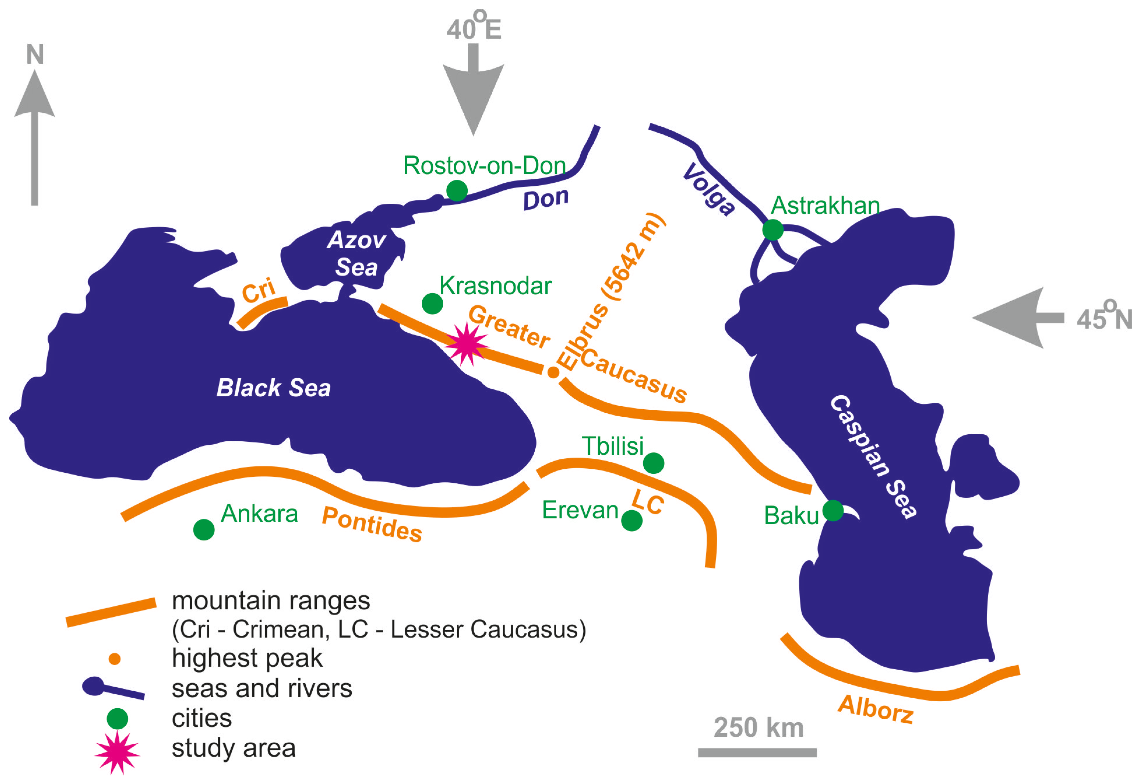
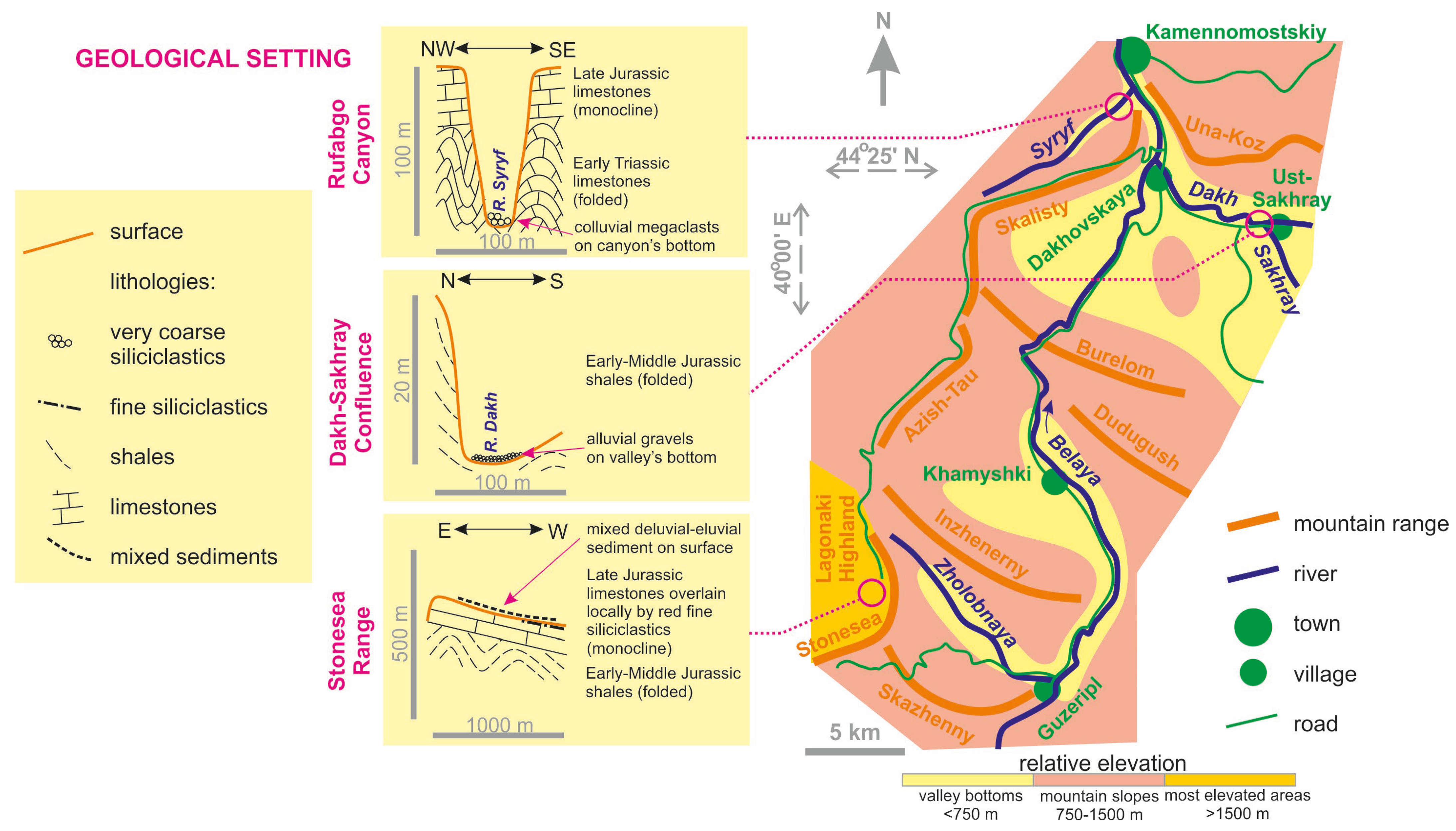
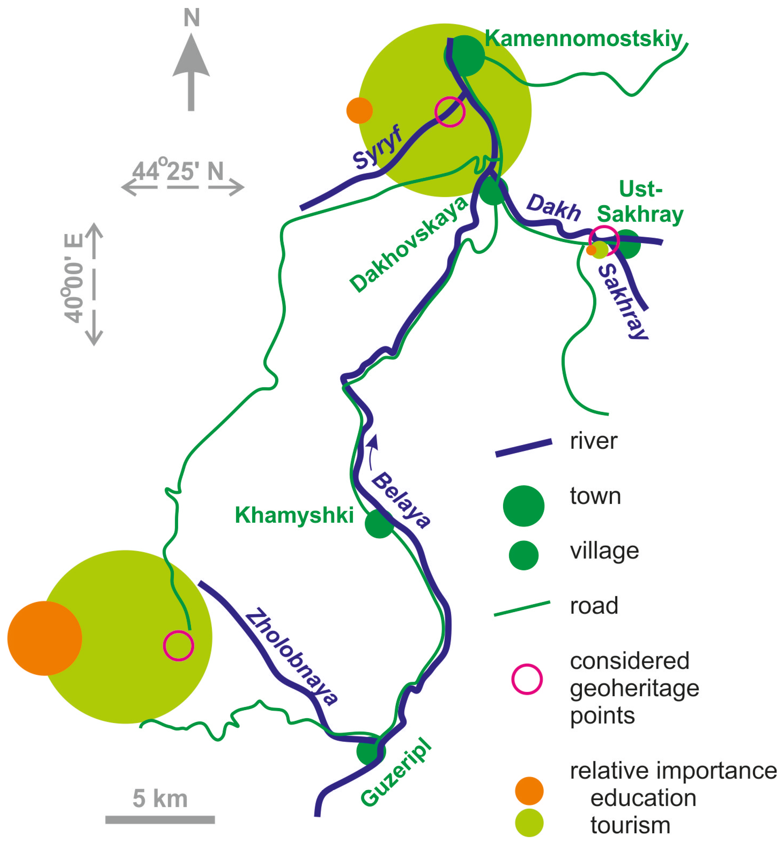
2.1. Study Area
2.2. Approach
3. Results
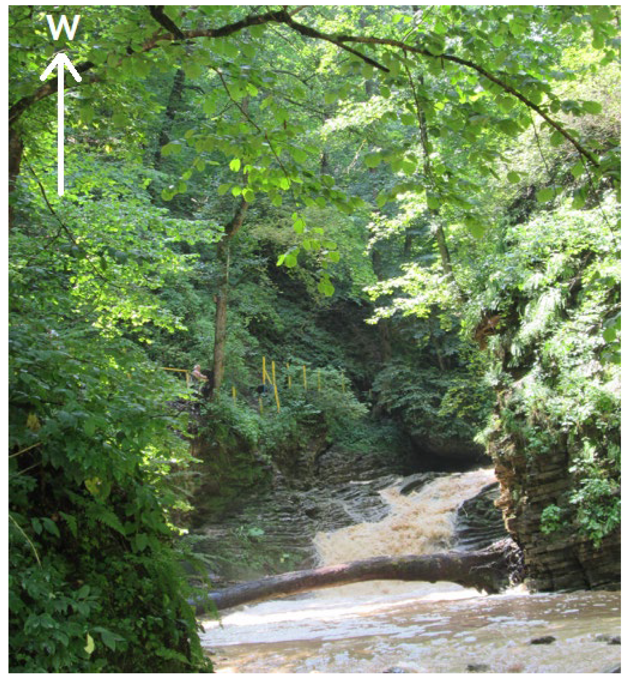
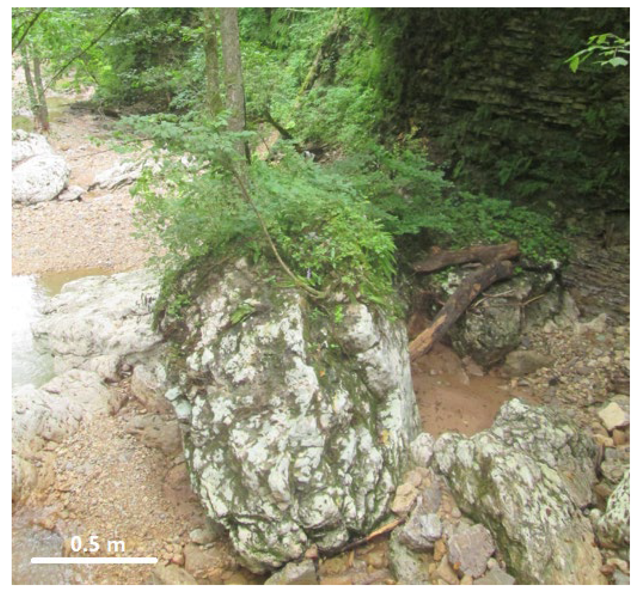
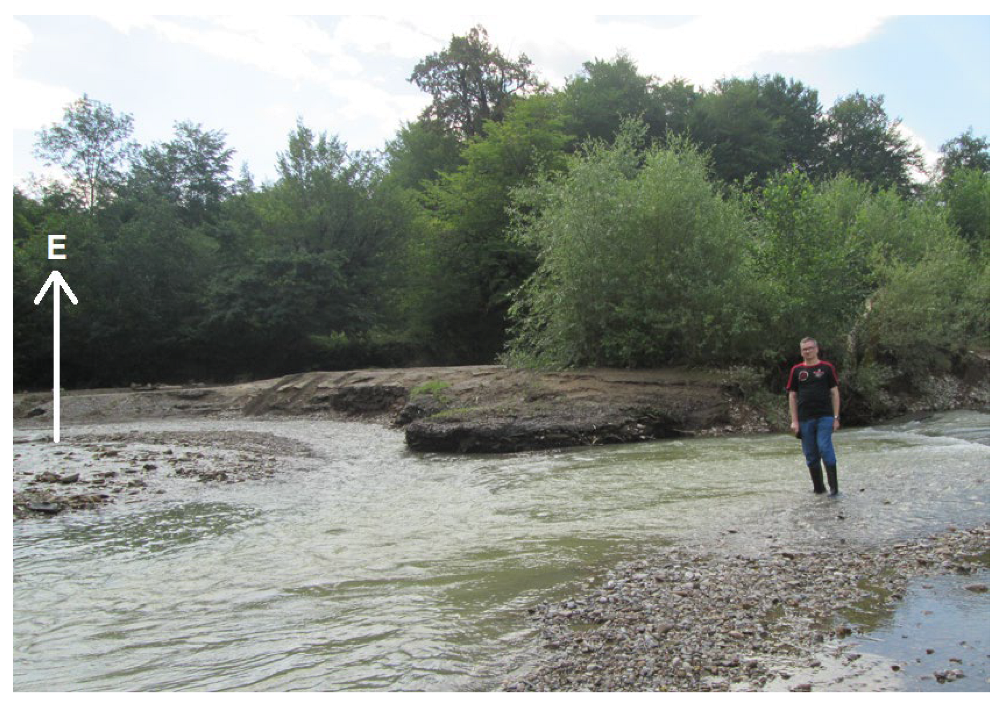
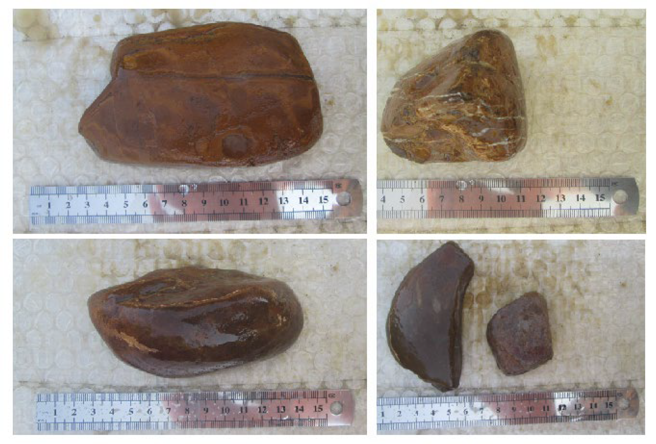
3.1. Rufabgo Canyon
3.2. Dakh–Sakhray Confluence
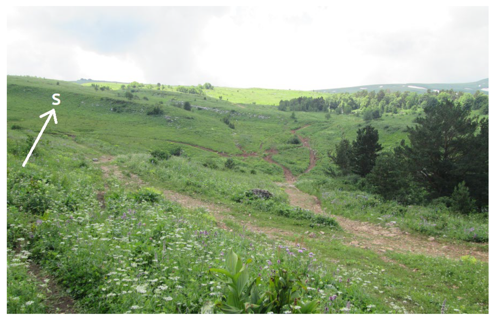
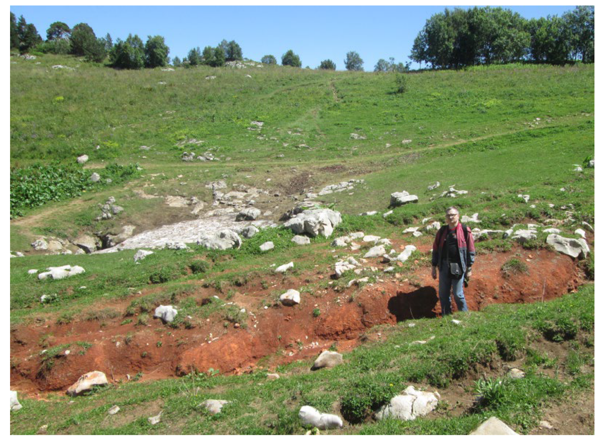
3.3. Stonesea Range
4. Discussion
4.1. General Geoheritage Interpretations
4.2. Geoheritage Utility
5. Conclusions
- (1)
- the three localities exhibit notable peculiarities of Late Quaternary alluvial, colluvial, and eluvial–deluvial sediments;
- (2)
- these localities are geoheritage points within larger geosites, and the knowledge about Quaternary sediments from the former contributes to the value of the latter;
- (3)
- Quaternary sediments with geoheritage value can be used for research, education, and tourism.
Funding
Institutional Review Board Statement
Informed Consent Statement
Data Availability Statement
Acknowledgments
Conflicts of Interest
References
- Bentivenga, M.; Cavalcante, F.; Mastronuzzi, G.; Palladino, G.; Prosser, G. Geoheritage: The Foundation for Sustainable Geotourism. Geoheritage 2019, 11, 1367–1369. [Google Scholar] [CrossRef]
- Guilbaud, M.-N.; Ortega-Larrocea, M.P.; Cram, S.; van Wyk de Vries, B. Xitle Volcano Geoheritage, Mexico City: Raising Awareness of Natural Hazards and Environmental Sustainability in Active Volcanic Areas. Geoheritage 2021, 13, 6. [Google Scholar]
- Herrera-Franco, G.; Carrión-Mero, P.; Montalván-Burbano, N.; Caicedo-Potosí, J.; Berrezueta, E. Geoheritage and Geosites: A Bibliometric Analysis and Literature Review. Geosciences 2022, 12, 169. [Google Scholar] [CrossRef]
- Jácome Paz, M.P.; Gómez Piña, V.M.; Prol Ledesma, R.M.; Gonzalez Romo, I.; Estrada Murillo, A.; Hernandez Hernandez, M.A.; González Alfaro, A.; Gómez Torres, M. Geoheritage in Thermal Springs of Puruándiro, Michoacán, México. Geoheritage 2021, 13, 68. [Google Scholar] [CrossRef]
- Neto, K.; Henriques, M.H. Geoconservation in Africa: State of the art and future challenges. Gondwana Res. 2022, 110, 107–113. [Google Scholar] [CrossRef]
- Quesada-Román, A.; Torres-Bernhard, L.; Ruiz-Alvarez, M.A.; Rodriguez-Maradiaga, M.; Velazquez-Espinoza, G.; Espinosa-Vega, C.; Toral, J.; Rodríguez-Bolaños, H. Geodiversity, Geoconservation, and Geotourism in Central America. Land 2022, 11, 48. [Google Scholar]
- Quesada-Román, A.; Zangmo, G.T.; Pérez-Umaña, D. Geomorphosite Comparative Analysis in Costa Rica and Cameroon Volcanoes. Geoheritage 2020, 12, 90. [Google Scholar] [CrossRef]
- Reynard, E.; Brilha, J. (Eds.) Geoheritage: Assessment, Protection, and Management; Elsevier: Amsterdam, The Netherlands, 2018. [Google Scholar]
- Urban, J.; Radwanek-Bąk, B.; Margielewski, W. Geoheritage Concept in a Context of Abiotic Ecosystem Services (Geosystem Services)—How to Argue the Geoconservation Better? Geoheritage 2022, 14, 54. [Google Scholar] [CrossRef]
- Corvea, J.L.; Gutiérrez, R.; Pascual-Aguilar, J.A.; de Bustamante, I.; Blanco, A. Geoheritage Integration in the Management of the Cuban Protected Areas. Geoheritage 2020, 12, 67. [Google Scholar] [CrossRef]
- Dowling, R.; Newsome, D. Handbook of Geotourism; Edward Elgar: Cheltenham, UK, 2018. [Google Scholar]
- Herrera-Franco, G.; Montalván-Burbano, N.; Carrión-Mero, P.; Apolo-Masache, B.; Jaya-Montalvo, M. Research trends in geotourism: A bibliometric analysis using the Scopus database. Geosciences 2020, 10, 379. [Google Scholar] [CrossRef]
- Pérez-Umaña, D.; Quesada-Román, A.; Zangmo Tefogoum, G. Geomorphological heritage inventory of Irazú Volcano, Costa Rica. Int. J. Geoheritage Park. 2020, 8, 31–47. [Google Scholar] [CrossRef]
- Quesada-Román, A.; Pérez-Umaña, D. Tropical Paleoglacial Geoheritage Inventory for Geotourism Management of Chirripó National Park, Costa Rica. Geoheritage 2020, 12, 58. [Google Scholar] [CrossRef]
- Reyes, C.A.R.; Amorocho-Parra, R.; Villarreal-Jaimes, C.A.; Meza-Ortiz, J.A.; Castallanos-Alarcon, O.M.; Madero-Pinzon, H.D.; Casadiego-Quintero, E.; Carvajal-Díaz, J.D. Geotourism in Regions with Influence from the Oil Industry: A Study Case of the Middle Magdalena Valley Basin (Colombia). Geoheritage 2021, 13, 107. [Google Scholar] [CrossRef]
- Tiago, F.; Correia, P.; Briciu, V.-A.; Borges-Tiago, T. Geotourism destinations online branding co-creation. Sustainability 2021, 13, 8874. [Google Scholar] [CrossRef]
- Clifford, P.; Semeniuk, V. Sedimentary processes, stratigraphic sequences and middens: The link between archaeology and geoheritage—A case study from the Quaternary of the Broome region, Western Australia. Aust. J. Earth Sci. 2019, 66, 955–972. [Google Scholar] [CrossRef]
- Dempster, M.; Enlander, I.J. Conserving Quaternary geoheritage in Northern Ireland. Proc. Geol. Assoc. 2022. [Google Scholar] [CrossRef]
- Duan, Z.; Zhang, X.; Zhou, C.; Yu, M.-G.; Chu, P.-L.; Hong, W.-T. Characteristics and Geological Significance of Quaternary Volcanic Geoheritages in Northern Hainan Island. Acta Geosci. Sin. 2021, 42, 111–123. [Google Scholar]
- Górska-Zabielska, M.; Wieczorek, D.; Zabielski, R.; Stoiński, A. Erratic boulders from the Przedbórz Region as objects important for Quaternary geology and geoheritage. Prz. Geol. 2022, 70, 34–49. [Google Scholar]
- Németh, K.; Wu, J.; Sun, C.; Liu, J. Update on the Volcanic Geoheritage Values of the Pliocene to Quaternary Arxan–Chaihe Volcanic Field, Inner Mongolia, China. Geoheritage 2017, 9, 279–297. [Google Scholar] [CrossRef]
- Niculiță, M. The Need for Protecting, Promoting, and Managing a Quaternary Geoheritage Site: Bahluieț Valley at Costești Village (Moldavian Plateau, North-Eastern Romania). Geoheritage 2022, 14, 21. [Google Scholar] [CrossRef]
- Ruban, D.A.; Mikhailenko, A.V.; Yashalova, N.N. Valuable geoheritage resources: Potential versus exploitation. Resour. Policy 2022, 77, 102665. [Google Scholar] [CrossRef]
- Bedanokov, M.K.; Chich, S.K.; Chetyz, D.Y.; Trepet, S.A.; Lebedev, S.A.; Kostianoy, A.G. Physicogeographical characteristics of the Republic of Adygea. Handb. Environ. Chem. 2020, 106, 19–55. [Google Scholar]
- Lozovoy, S.P. Lagonaki Highland; Krasnodarskoe Knizhnoe Izdatel’stvo: Krasnodar, Russia, 1984; p. 160. (In Russian) [Google Scholar]
- Nazarenko, O.V.; Mikhailenko, A.V.; Smagina, T.A.; Kutilin, V.S. Natural Conditions of Mountainous Adygeya; SFU: Rostov-on-Don, Russia, 2020. (In Russian) [Google Scholar]
- Ruban, D.A.; Mikhailenko, A.V.; Ermolaev, V.A. Inverted Landforms of the Western Caucasus: Implications for Geoheritage, Geotourism, and Geobranding. Heritage 2022, 5, 2315–2331. [Google Scholar] [CrossRef]
- Adamia, S.; Zakariadze, G.; Chkhotua, T.; Sadradze, N.; Tsereteli, N.; Chabukiani, A.; Gventsadze, A. Geology of the Caucasus: A review. Turk. J. Earth Sci. 2011, 20, 489–544. [Google Scholar] [CrossRef]
- Mosar, J.; Mauvilly, J.; Koiava, K.; Gamkrelidae, I.; Enna, N.; Lavrishev, V.; Kalberguenova, V. Tectonics in the Greater Caucasus (Georgia—Russia): From an intracontinental rifted basin to a doubly verging fold-and-thrust belt. Mar. Pet. Geol. 2022, 140, 105630. [Google Scholar] [CrossRef]
- Rolland, Y. Caucasus collisional history: Review of data from East Anatolia to West Iran. Gondwana Res. 2017, 49, 130–146. [Google Scholar] [CrossRef]
- Adamia, S.; Alania, V.; Chabukiani, A.; Kutelia, Z.; Sadradze, N. Great Caucasus (Cavcasioni): A long-lived north-tethyan back-arc basin. Turk. J. Earth Sci. 2011, 20, 611–628. [Google Scholar] [CrossRef]
- Ruban, D.A. The Greater Caucasus—A Galatian or Hanseatic terrane? Comment on “The formation of Pangea” by GM Stampfli, C. Hochard, C. Vérard, C. Wilhem and J. von Raumer [Tectonophysics 593 (2013) 1–19]. Tectonophysics 2013, 608, 1442–1444. [Google Scholar]
- Plyusnina, E.E.; Ruban, D.A.; Zayats, P.P. Thematic dimension of geological heritage: An evidence from the Western Caucasus. J. Geogr. Inst. “Jovan Cvijic” SASA 2015, 65, 59–76. [Google Scholar] [CrossRef]
- Ruban, D.A. Islands in the Caucasian Sea in Three Mesozoic Time Slices: Novel Dimension of Geoheriatge and Geotourism. J. Mar. Sci. Eng. 2022, 10, 1300. [Google Scholar] [CrossRef]
- Scherbakova, E.M. Ancient Glaciation of the Greater Caucasus; Moscow University Press: Moscow, Russia, 1973. (In Russian) [Google Scholar]
- International Commission on Stratigraphy (ICS). International Chronostratigraphic Chart v2022/02. Available online: https://stratigraphy.org/chart (accessed on 23 September 2022).
- Blair, T.C.; McPherson, J.G. Grain-size and textural classification of coarse sedimentary particles. J. Sediment. Res. 1999, 69, 6–19. [Google Scholar] [CrossRef]
- Blott, S.J.; Pye, K. Particle size scales and classification of sediment types based on particle size distributions: Review and recommended procedures. Sedimentology 2012, 59, 2071–2096. [Google Scholar] [CrossRef]
- Bruno, D.E.; Ruban, D.A. Something more than boulders: A geological comment on the nomenclature of megaclasts on extraterrestrial bodies. Planet. Space Sci. 2017, 135, 37–42. [Google Scholar] [CrossRef]
- Terry, J.P.; Goff, J. Megaclasts: Proposed revised nomenclature at the coarse end of the Udden-Wentworth gain-size scale for sedimentary particles. J. Sediment. Res. 2014, 84, 192–197. [Google Scholar] [CrossRef]
- Chauhan, G.; Biswas, S.K.; Thakkar, M.G.; Page, K.N. The Unique Geoheritage of the Kachchh (Kutch) Basin, Western India, and its Conservation. Geoheritage 2021, 13, 23. [Google Scholar] [CrossRef]
- Woo, K.S.; Chun, S.S.; Moon, K.O. Outstanding Geoheritage Values of the Island-Type Tidal Flats in Korea. Geoheritage 2020, 12, 8. [Google Scholar] [CrossRef]
- Brilha, J. Inventory and quantitative assessment of geosites and geodiversity sites: A review. Geoheritage 2016, 8, 119–134. [Google Scholar] [CrossRef]
- Bruschi, V.M.; Cendrero, A.; Albertos, J.A.C. A statistical approach to the validation and optimisation of geoheritage assessment procedures. Geoheritage 2011, 3, 131–149. [Google Scholar] [CrossRef]
- Mucivuna, V.C.; Reynard, E.; Garcia, M.G.M. Geomorphosites Assessment Methods: Comparative Analysis and Typology. Geoheritage 2019, 11, 1799–1815. [Google Scholar] [CrossRef]
- Mucivuna, V.C.; Motta Garcia, M.D.G.; Reynard, E. Comparing quantitative methods on the evaluation of scientific value in geosites: Analysis from the Itatiaia National Park, Brazil. Geomorphology 2022, 396, 107988. [Google Scholar] [CrossRef]
- Quesada-Valverde, M.E.; Quesada-Román, A. Worldwide Trends in Methods and Resources Promoting Geoconservation, Geotourism, and Geoheritage. Geosciences 2023, 13, 39. [Google Scholar] [CrossRef]
- Štrba, L.; Rybar, P.; Balaz, B.; Molokac, M.; Hvizdak, L.; Krsak, B.; Lukac, M.; Muchova, L.; Tometzova, D.; Ferencikova, J. Geosite assessments: Comparison of methods and results. Curr. Issues Tour. 2015, 18, 496–510. [Google Scholar] [CrossRef]
- Corbí, H.; Fierro, I.; Aberasturi, A.; Sánchez Ferris, E.J. Potential Use of a Significant Scientific Geosite: The Messinian Coral Reef of Santa Pola (SE Spain). Geoheritage 2018, 10, 427–441. [Google Scholar] [CrossRef]
- Fernández, M.P.; Timón, D.L.; Marín, R.G. Geosites Inventory in the Geopark Villuercas-Ibores-Jara (Extremadura, Spain): A Proposal for a New Classification. Geoheritage 2014, 6, 17–27. [Google Scholar] [CrossRef]
- Pereira, D.I.; Pereira, P.; Brilha, J.; Cunha, P.P. The Iberian Massif Landscape and Fluvial Network in Portugal: A geoheritage inventory based on the scientific value. Proc. Geol. Assoc. 2015, 126, 252–265. [Google Scholar] [CrossRef]
- Reynard, E.; Perret, A.; Bussard, J.; Grangier, L.; Martin, S. Integrated Approach for the Inventory and Management of Geomorphological Heritage at the Regional Scale. Geoheritage 2016, 8, 43–60. [Google Scholar] [CrossRef]
- Yusry, M.; Simon, N.; Unjah, T. Geodiversity and geoheritage assessment in Hulu Langat district, Selangor, Malaysia. Geoj. Tour. Geosites 2018, 23, 861–872. [Google Scholar]
- Lubova, K.A.; Zayats, P.P.; Ruban, D.A.; Tiess, G. Megaclasts in geoconservation: Sedimentological questions, anthropogenic influence, and geotourism potential. Geologos 2013, 19, 321–335. [Google Scholar] [CrossRef]
- Killingback, Z.; Holdsworth, R.E.; Walker, R.J.; Nielsen, S.; Dempsey, E.; Hardman, K. A Bigger Splat: The Catastrophic Geology of a 1.2-b.y.-old Terrestrial Megaclast, Northwest Scotland. Geology 2021, 49, 180–184. [Google Scholar] [CrossRef]
- Lorang, M.S. A wave-competence approach to distinguish between boulder and megaclast deposits due to storm waves versus tsunamis. Mar. Geol. 2011, 283, 90–97. [Google Scholar] [CrossRef]
- Gale, S.J.; Ibrahim, Z.Z.; Lal, J.; Sicinilawa, U.B.T. Downstream fining in a megaclast-dominated fluvial system: The Sabeto River of western Viti Levu, Fiji. Geomorphology 2019, 330, 151–162. [Google Scholar] [CrossRef]
- Rostovtsev, K.O.; Agaev, V.B.; Azarian, N.R.; Babaev, R.G.; Besnosov, N.V.; Hassanov, N.A.; Zesashvili, V.I.; Lomize, M.G.; Paitschadze, T.A.; Panov, D.I.; et al. Jurassic of the Caucasus; Nauka: St. Petersburg, Russia, 1992. (In Russian) [Google Scholar]
- Teodorovitch, G.I.; Pokhvisneva, E.A. Lithology and Diagenesis of the Jurassic Deposits of the North-Western Caucasus; Nauka: Moscow, Russia, 1964. (In Russian) [Google Scholar]
- Gavrilov, Y.O. Dynamics of Formation of the Jurassic Terrigeneous Complex of the Greater Caucasus; GEOS: Moskva, Russia, 2004. (In Russian) [Google Scholar]
- Al-Dhwadi, Z.; Sallam, E.S. Spheroidal “Cannonballs” calcite-cemented concretions from the Faiyum and Bahariya depressions, Egypt: Evidence of differential erosion by sand storms. Int. J. Earth Sci. 2019, 108, 2291–2293. [Google Scholar] [CrossRef]
- Konigsmark, T. Geologic Trips, Sea Ranch and Bowling Ball Beach; GeoPress: Medford, MA, USA, 2005. [Google Scholar]
- Posilović, H.; Galović, L.; Stejić, P.; Pandurov, M.; Gajić, R. Quaternary depositional environments in the Vrgoračko Polje/Lake (SE Croatia). Geol. Croat. 2018, 71, 147–162. [Google Scholar] [CrossRef]
- Duszyński, F.; Migoń, P.; Strzelecki, M.C. Escarpment retreat in sedimentary tablelands and cuesta landscapes—Landforms, mechanisms and patterns. Earth-Sci. Rev. 2019, 196, 102890. [Google Scholar] [CrossRef]
- Ruban, D.A.; Zorina, S.O.; Rebezov, M.B. Dispersed geoheritage points of the Lagonaki Highland, SW Russia: Contribution to local geoheritage resource. Geosciences 2019, 9, 367. [Google Scholar] [CrossRef]
- Hjort, J.; Tukiainen, H.; Salminen, H.; Kemppinen, J.; Kiilunen, P.; Snåre, H.; Alahuhta, J.; Maliniemi, T. A methodological guide to observe local-scale geodiversity for biodiversity research and management. J. Appl. Ecol. 2022, 59, 1756–1768. [Google Scholar] [CrossRef]
- Frost, W.; Steingötter, K. Geotrope survey of Rheinland-Palatinate. Mainz. Geowiss. Mitt. 2001, 30, 271–302. [Google Scholar]
- Šilhán, K.; Feher, R. Geotope of boulder accumulations: Possible source of noise in the dendrogeomorphic dating of landslides. Catena 2022, 213, 106142. [Google Scholar] [CrossRef]
- Zafeiropoulos, G.; Drinia, H. Kalymnos island, SE Aegean Sea: From fishing sponges and rock climbing to geotourism perspective. Heritage 2021, 4, 3126–3146. [Google Scholar] [CrossRef]
- Kirillova, K.; Fu, X.; Lehto, X.; Cai, L. What makes a destination beautiful? Dimensions of tourist aesthetic judgment. Tour. Manag. 2014, 42, 282–293. [Google Scholar] [CrossRef]
- Jonauskaite, D.; Abu-Akel, A.; Dael, N.; Oberfeld, D.; Abdel-Khalek, A.M.; Al-Rasheed, A.S.; Antonietti, J.-P.; Bogushevskaya, V.; Chamseddine, A.; Chkonia, E.; et al. Universal patterns in color-emotion associations are further shaped by linguistic and geographic proximity. Psychol. Sci. 2020, 31, 1245–1260. [Google Scholar] [CrossRef]
- Górska-Zabielska, M. The most valuable erratic boulders in the Wielkopolska region of western Poland and their potential to promote geotourism. Geoj. Tour. Geosites 2020, 29, 694–714. [Google Scholar] [CrossRef]
- Górska-Zabielska, M. Geoheritage in a Forest: Traces of Ice Sheets in Pałuki, Western Poland. Sustainability 2022, 14, 7190. [Google Scholar] [CrossRef]
- Górska-Zabielska, M.; Witkowska, K.; Pisarska, M.; Musiał, R.; Jońca, B. The Selected Erratic Boulders in the Świętokrzyskie Province (Central Poland) and Their Potential to Promote Geotourism. Geoheritage 2020, 12, 30. [Google Scholar] [CrossRef]
- De Waele, J.; Di Gregorio, F.; Gasmi, N.; Melis, M.T.; Talbi, M. Geomorphosites of Tozeur region (south-west Tunisia). Alp. Mediterr. Quat. 2005, 18, 223–232. [Google Scholar]
- Lokier, S.W. Coastal Sabkha Preservation in the Arabian Gulf. Geoheritage 2013, 5, 11–22. [Google Scholar] [CrossRef]
- Pérez-Hernández, E.; Peña-Alonso, C.; Fernández-Cabrera, E.; Hernández-Calvento, L. Assessing the scenic quality of transgressive dune systems on volcanic islands. The case of Corralejo (Fuerteventura island, Spain). Sci. Total Environ. 2021, 784, 147050. [Google Scholar] [CrossRef] [PubMed]
- Tikhonenkov, D.V.; Jamy, M.; Borodina, A.S.; Belyaev, A.O.; Zagumyonnyi, D.G.; Prokina, K.I.; Mylnikov, A.P.; Burki, F.; Karpov, S.A. On the origin of TSAR: Morphology, diversity and phylogeny of Telonemia. Open Biol. 2022, 12, 210325. [Google Scholar] [CrossRef]
- Bibin, A.S.; Trepet, S.A.; Grabenko, E.A.; Akatov, T.V. Shaposhnikov Caucasian State Nature Biosphere Reserve. Handb. Environ. Chem. 2020, 106, 603–631. [Google Scholar]
- Litvinskaya, S.A. Florophytocenotic diversity of the Western Caucasus. South Russ. Ecol. Dev. 2020, 15, 37–48. [Google Scholar] [CrossRef]


| Parameter | Essence | Special Notes |
|---|---|---|
| Location | Where is the locality, and how does it look physically? | - |
| Geological setting | Composition and age of “parent” rocks | The ICS’s developments [36] are followed. |
| Quaternary feature | General view of sediments (with an emphasis on their composition and distribution) | See classifications by Blair and McPherson [37], Blott and Pye [38], Bruno and Ruban [39], and Terry and Goff [40], from which [39] is derived. |
| Origin | Genesis of sediments | Old-fashioned but still suitable terms such as “alluvium”, “colluvium”, “deluvium”, and “eluvium” are used. |
| Possible age | When did sediments start to form? | Only very approximate judgments are possible. |
| Significance | Why should this locality be interesting to specialists? | - |
| Accessibility | How easy is to access the locality and to move within it? | - |
| Characteristic | Geoheritage Points | ||
|---|---|---|---|
| Rufabgo Canyon | Dakh–Sakhray Confluence | Stonesea Range | |
| Spatial correspondence to geosite (parent Geosite) * | Khadzhokh canyon system and Rufabgo waterfalls | Sakhray canyon | Lagonaki Highland |
| Portion of geosite * | ~25% | <5% | <5% |
| Relative uniqueness ** | High | Low | High |
| Degree of scientific investigation ** | High | Moderate | Low |
| Accessibility * | High (entrance fee required) | High (unpaved road) | High (hiking, entrance fee required) |
| Vulnerability ** | Absent | Absent | Minimal |
| Aesthetic value ** | High | Minimal | High |
Disclaimer/Publisher’s Note: The statements, opinions and data contained in all publications are solely those of the individual author(s) and contributor(s) and not of MDPI and/or the editor(s). MDPI and/or the editor(s) disclaim responsibility for any injury to people or property resulting from any ideas, methods, instructions or products referred to in the content. |
© 2023 by the author. Licensee MDPI, Basel, Switzerland. This article is an open access article distributed under the terms and conditions of the Creative Commons Attribution (CC BY) license (https://creativecommons.org/licenses/by/4.0/).
Share and Cite
Ruban, D.A. Quaternary Sediments in Geosites: Evidence from the Western Caucasus. Heritage 2023, 6, 3903-3920. https://doi.org/10.3390/heritage6050207
Ruban DA. Quaternary Sediments in Geosites: Evidence from the Western Caucasus. Heritage. 2023; 6(5):3903-3920. https://doi.org/10.3390/heritage6050207
Chicago/Turabian StyleRuban, Dmitry A. 2023. "Quaternary Sediments in Geosites: Evidence from the Western Caucasus" Heritage 6, no. 5: 3903-3920. https://doi.org/10.3390/heritage6050207
APA StyleRuban, D. A. (2023). Quaternary Sediments in Geosites: Evidence from the Western Caucasus. Heritage, 6(5), 3903-3920. https://doi.org/10.3390/heritage6050207