
Geo-Environmental Assessment of Tourist Development and Its Impact on Sustainability

 ,
,  , ,
, ,  and
and
Abstract
1. Introduction
2. Materials and Methods
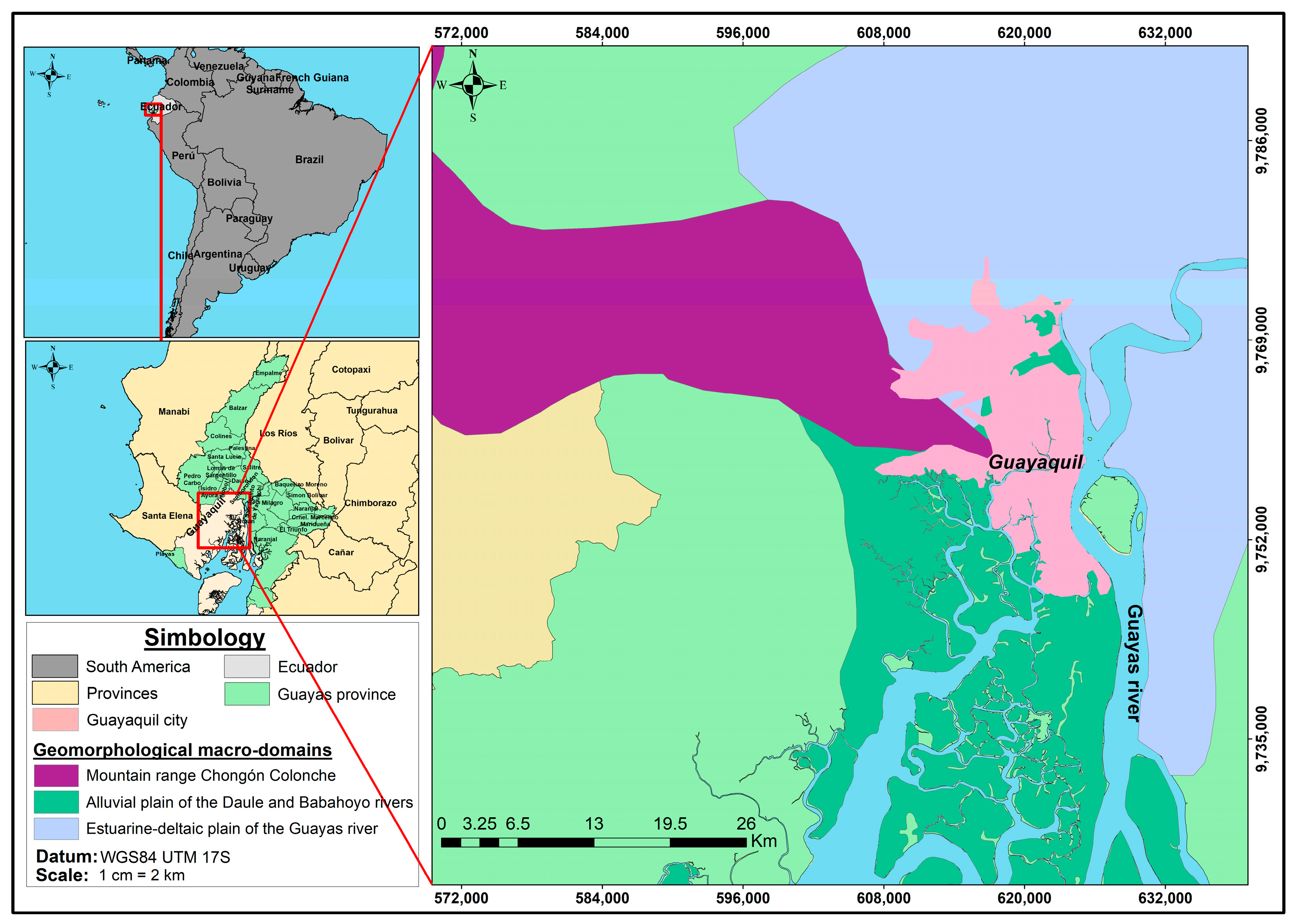
2.1. Geographical Registration and Characteristics of Sites of Interest
2.2. Environmental Analysis of the Sites Evaluated Based on the Cause–Effect Method
2.3. Analysis of Results and Strategies for Including Sites in a Geo-Environmental and Geotourism System
3. Results
3.1. Registration of Sites of Interest and Their Main Aspects Identified
3.2. Environmental Aspects of the Guayaquil Geosites
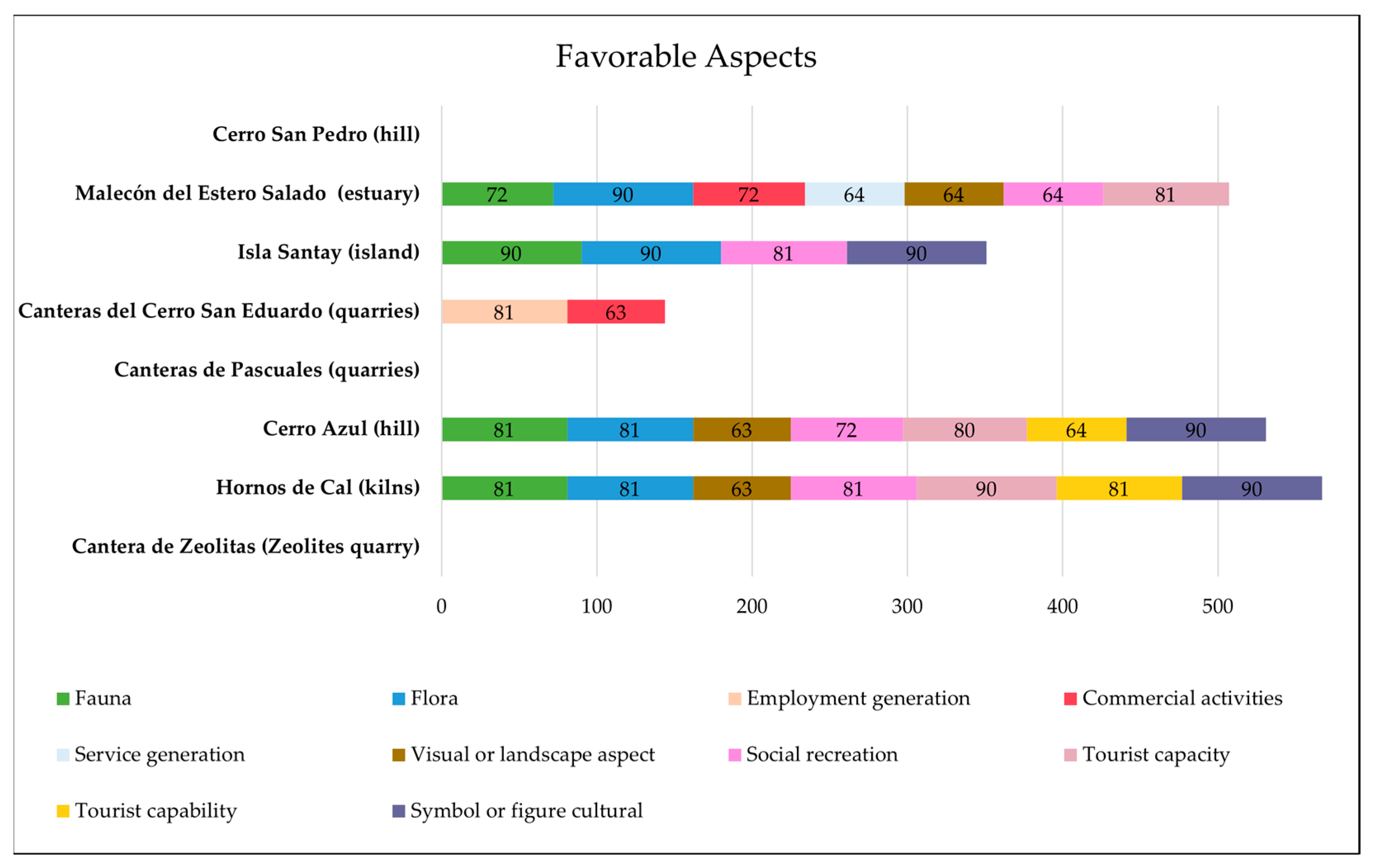
3.3. Most Significant Favorable Environmental Aspects
3.4. Most Significant Unfavorable Environmental Aspects
3.5. Average Impact Value at Sites of Interest
3.6. Strategies for the Sustainability Proposal
4. Discussion
5. Conclusions
Supplementary Materials
Author Contributions
Funding
Data Availability Statement
Acknowledgments
Conflicts of Interest
References
- Basilone, L.; Di Maggio, C. Geology of Monte Gallo (Palermo Mts, NW Sicily). J. Maps 2016, 12, 1072–1083. [Google Scholar] [CrossRef]
- Filocamo, F.; Rosskopf, C.M.; Amato, V. A Contribution to the Understanding of the Apennine Landscapes: The Potential Role of Molise Geosites. Geoheritage 2019, 11, 1667–1688. [Google Scholar] [CrossRef]
- Szepesi, J.; Ésik, Z.; Soós, I.; Németh, B.; Sütő, L.; Novák, T.J.; Harangi, S.; Lukács, R. Identification of Geoheritage Elements in a Cultural Landscape: A Case Study from Tokaj Mts, Hungary. Geoheritage 2020, 12, 89. [Google Scholar] [CrossRef]
- Carrión-Mero, P.; Herrera-Narváez, G.; Herrera-Franco, G.; Sánchez-Zambrano, E.; Mata-Perelló, J.; Berrezueta, E. Assessment and Promotion of Geotouristic and Geomining Routes as a Basis for Local Development: A Case Study. Minerals 2021, 11, 351. [Google Scholar] [CrossRef]
- Gray, M. Geodiversity: The Backbone of Geoheritage and Geoconservation; Elsevier Inc.: Amsterdam, The Netherlands, 2018; ISBN 9780128095423. [Google Scholar]
- Kozłowski, S. Geodiversity. The Concept and Scope of Geodiversity. Prz. Geol. 2004, 52, 833–837. [Google Scholar]
- Muzambiq, S.; Walid, H.; Ganie, T.H.; Hermawan, H. The Importance of Public Education and Interpretation in the Conservation of Toba Caldera Geoheritage. Geoheritage 2021, 13, 1–9. [Google Scholar] [CrossRef]
- Manríquez, H.; Mansilla, P.; Figueroa-Sterquel, R.; Moreira-Muñoz, A. Geodiversity Meets Biodiversity: A Landscape Approach for Biogeocultural Conservation and Governance in Mediterranean Central Chile. eco.mont. J. Prot. Mt. Areas Res. 2019, 11, 43–48. [Google Scholar] [CrossRef]
- Betard, F.; Peulvast, J.-P.; de Oliveira Magalhâes, A. Biodiversité, Géodiversité et Enjeux de Leur Conservation Dans Les Montagnes Humides Du Nordeste Brésilien (Biodiversity, Geodiversity and Conservation Challenges in the Humid Mountains of Northeast Brazil). Bull. Assoc. Geogr. Fr. 2011, 88, 17–26. [Google Scholar] [CrossRef]
- Mehdipour Ghazi, J.; Hamdollahi, M.; Moazzen, M. Geotourism of Mining Sites in Iran: An Opportunity for Sustainable Rural Development. Int. J. Geoheritage Park. 2021, 9, 129–142. [Google Scholar] [CrossRef]
- Bentivenga, M.; Palladino, G.; Prosser, G.; Guglielmi, P.; Geremia, F.; Laviano, A. A Geological Itinerary through the Southern Apennine Thrust Belt (Basilicata—Southern Italy). Geoheritage 2017, 9, 1–17. [Google Scholar] [CrossRef]
- Lewis, I. Linking Geoheritage Sites: Geotourism and a Prospective Geotrail in the Flinders Ranges World Heritage Nomination Area, South Australia. Aust. J. Earth Sci. 2020, 67, 1195–1210. [Google Scholar] [CrossRef]
- De Waele, J.; Di Gregorio, F.; Gasmi, N.; Melis, M.T.; Talbi, M. Geomorphosites of Tozeur Region (South-West Tunisia). Alp. Mediterr. Quat. 2005, 18, 223–232. [Google Scholar]
- Ruchkys, Ú.A.; Machado, M.M.M. Geological and Mining Heritage of Iron Quadrangle, Minas Gerais-Characterization and Strategies for Education and Geotourism | Patrimônio Geológico e Mineiro Do Quadrilátero Ferrífero, Minas Gerais-Caracterização e Iniciativas de Uso Para Educação e G. Bol. Parana. Geosci. 2013, 70, 120–136. [Google Scholar]
- Carrión-Mero, P.; Montalván-Burbano, N.; Herrera-Narváez, G.; Morante-Carballo, F. Geodiversity and Mining towards the Development of Geotourism: A Global Perspective. Int. J. Des. Nat. Ecodynamics 2021, 16, 191–201. [Google Scholar] [CrossRef]
- Reynard, E.; Brilha, J. Geoheritage: A Multidisciplinary and Applied Research Topic; Reynard, E., Brilha, J.B.T.-G., Eds.; Elsevier: Amsterdam, The Netherlands, 2018; pp. 3–9. ISBN 978-0-12-809531-7. [Google Scholar]
- Gray, M. Geodiversity: Developing the Paradigm. Proc. Geol. Assoc. 2008, 119, 287–298. [Google Scholar] [CrossRef]
- Pereira, D.I.; Pereira, P.; Brilha, J.; Santos, L. Geodiversity Assessment of Paraná State (Brazil): An Innovative Approach. Environ. Manag. 2013, 52, 541–552. [Google Scholar] [CrossRef]
- Ruban, D.A.; Sallam, E.S.; Khater, T.M.; Ermolaev, V.A. Golden Triangle Geosites: Preliminary Geoheritage Assessment in a Geologically Rich Area of Eastern Egypt. Geoheritage 2021, 13, 54. [Google Scholar] [CrossRef]
- Goswami, S.; Singh, K.J. Floral Biodiversity and Geology of the Talcher Basin, Orissa, India during the Permian–Triassic Interval. Geol. J. 2013, 48, 39–56. [Google Scholar] [CrossRef]
- Emerson, B.C. Genes, Geology and Biodiversity: Faunal and Floral Diversity on the Island of Gran Canaria | Genes, Geología y Biodiversidad: Diversidad de La Fauna y Flora de La Isla de Gran Canaria. Anim. Biodivers. Conserv. 2003, 26, 9–20. [Google Scholar]
- Comănescu, L.; Nedelea, A. The Assessment of Geodiversity–a Premise for Declaring the Geopark Buzăului County (Romania). J. Earth Syst. Sci. 2012, 121, 1493–1500. [Google Scholar] [CrossRef]
- da Silva, M.L.N.; Do Nascimento, M.A.L.; Mansur, K.L. Geoprocessing Applied to the Quantitative Evaluation of Geodiversity in the Area of SeridÓ Aspiring Geopark–Rn | Geoprocessamento Aplicado à Avaliação Quantitativa Da Geodiversidade Na Área Do Geoparque Aspirante Seridó–Rn. Geociencias 2020, 39, 727–737. [Google Scholar] [CrossRef]
- Wang, Y.; Wu, F.; Li, X.; Chen, L. Geotourism, Geoconservation, and Geodiversity along the Belt and Road: A Case Study of Dunhuang UNESCO Global Geopark in China. Proc. Geol. Assoc. 2019, 130, 232–241. [Google Scholar] [CrossRef]
- Sinnyovsky, D. Geopark Belogradchik Rocks-Priority of the Bulgarian Geoconservation. In Proceedings of the 11th International Multidisciplinary Scientific Geoconference and EXPO-Modern Management of Mine Producing, Geology and Environmental Protection, SGEM 2011, Varna, Bulgaria, 19–25 June 2011; Volume 3, pp. 389–396. [Google Scholar]
- Herrera-Franco, G.; Carrión-Mero, P.; Morante-Carballo, F.; Herrera-Narváez, G.; Briones-Bitar, J.; Blanco-Torrens, R. Strategies for the Development of the Value of the Mining-Industrial Heritage of the Zaruma-Portovelo, Ecuador, in the Context of a Geopark Project. Int. J. Energy Prod. Manag. 2020, 5, 48–59. [Google Scholar] [CrossRef]
- Piranha, J.M.; Aparecida Del Lama, E.; de La Corte Bacci, D. Geoparks in Brazil—Strategy of Geoconservation and Development. Geoheritage 2011, 3, 289–298. [Google Scholar] [CrossRef]
- Ólafsdóttir, R.; Dowling, R. Geotourism and Geoparks—A Tool for Geoconservation and Rural Development in Vulnerable Environments: A Case Study from Iceland. Geoheritage 2014, 6, 71–87. [Google Scholar] [CrossRef]
- Brown, G. Mapping Landscape Values and Development Preferences: A Method for Tourism and Residential Development Planning. Int. J. Tour. Res. 2006, 8, 101–113. [Google Scholar] [CrossRef]
- Sánchez-Cortez, J.L.; Simbaña-Tasiguano, M. Geoparks and Their Implantation in Latin America. Estud. Geogr. 2018, 79, 445–467. [Google Scholar] [CrossRef]
- Farsani, N.T.; Coelho, C.O.A.; Costa, C.M.M. Analysis of Network Activities in Geoparks as Geotourism Destinations. Int. J. Tour. Res. 2014, 16, 1–10. [Google Scholar] [CrossRef]
- Dowling, R.K. Geotourism’s Global Growth. Geoheritage 2011, 3, 1–13. [Google Scholar] [CrossRef]
- UNESCO List of UNESCO Global Geoparks (UGGp). Available online: https://www.unesco.org/en/articles/unesco-designates-8-new-global-geoparks (accessed on 4 January 2023).
- Jones, C. History of Geoparks. Geol. Soc. Lond. Spec. Publ. 2008, 300, 273–277. [Google Scholar] [CrossRef]
- Ruban, D.A. Geodiversity as a Precious National Resource: A Note on the Role of Geoparks. Resour. Policy 2017, 53, 103–108. [Google Scholar] [CrossRef]
- Roig-Munar, F.X.; Martín-Prieto, J.Á.; Rodríguez-Perea, A.; Gelabert, B.; Vilaplana, J.M. Proposed Geosites for Tsunamitic Blocks in the Rocky Coasts of Formentera (Balearic Islands) | Propuesta de Lugares de Interés Geológico Asociados a Bloques de Origen Tsunamítico En Las Costas Rocosas de La Isla de Formentera (Islas Baleares). Rev. Soc. Geol. Esp. 2018, 31, 35–48. [Google Scholar]
- Lopes, R.F.; Candeiro, C.R.A.; de Valais, S. Geoconservation of the Paleontological Heritage of the Geosite of Dinosaur Footprints (Sauropods) in the Locality of São Domingos, Municipality of Itaguatins, State of Tocantins, Brazil. Environ. Earth Sci. 2019, 78, 707. [Google Scholar] [CrossRef]
- Brilha, J. Inventories and Evaluation. Geoheritage: Assessment, Protection, and Management. In Geoheritage; Elsevier: Amsterdam, The Netherlands, 2018; pp. 69–85. [Google Scholar] [CrossRef]
- Reverte, F.C.; Garcia, M.G.M. Quantitative Evaluation of Geological Heritage: Application to Geosites of São Sebastião Nopthern Coast of São Paulo | Avaliação Quantitativa Do Patrimônio Geológico: Aplicação Aos Geossítios de São Sebastião, Litoral Norte Do Estado de São Paulo. Anu. Inst. Geocienc. 2016, 39, 43–56. [Google Scholar] [CrossRef]
- Carrión-Mero, P.; Morante-Carballo, F.; Herrera-Narváez, G.; Maldonado-Zamora, A.; Paz-Salas, N. The Context of Ecuador’s World Heritage, for Sustainable Development Strategies. Int. J. Des. Nat. Ecodynamics 2020, 15, 39–46. [Google Scholar] [CrossRef]
- Farsani, N.T.; Coelho, C.; Costa, C. Geotourism and Geoparks as Novel Strategies for Socio-Economic Development in Rural Areas. Int. J. Tour. Res. 2011, 13, 68–81. [Google Scholar] [CrossRef]
- Farsani, N.; Coelho, C.; Costa, C. Geotourism and Geoparks as Gateways to Socio-Cultural Sustainability in Qeshm Rural Areas, Iran. Asia Pac. J. Tour. Res. 2012, 17, 30–48. [Google Scholar] [CrossRef]
- Cleal, C.J.; Thomas, B.A.; Bevins, R.E.; Wimbledon, W.A.P. Geosites–an International Geoconservation Initiative. Geol. Today 1999, 15, 64–68. [Google Scholar] [CrossRef]
- Francesco, G.; Mario, B.; Giuseppe, P. Environmental Geology Applied to Geoconservation in the Interaction between Geosites and Linear Infrastructures in South-Eastern Italy. Geoheritage 2015, 7, 33–46. [Google Scholar] [CrossRef]
- Kubalíková, L.; Kirchner, K. Geosite and Geomorphosite Assessment as a Tool for Geoconservation and Geotourism Purposes: A Case Study from Vizovická Vrchovina Highland (Eastern Part of the Czech Republic). Geoheritage 2016, 8, 5–14. [Google Scholar] [CrossRef]
- Manosso, F.C. Potencial del Geoturismo y la Geodiversidad en la Serra Do Cadeano, Paraná, Brasil. Estud. Perspect. Tur. 2012, 21, 322–338. [Google Scholar]
- De Wever, P.; Baudin, F.; Pereira, D.; Cornée, A.; Egoroff, G.; Page, K. The Importance of Geosites and Heritage Stones in Cities—A Review. Geoheritage 2017, 9, 561–575. [Google Scholar] [CrossRef]
- Joyce, E.B. Geological Heritage of Australia: Selecting the Best for Geosites and World Heritage, and Telling the Story for Geotourism and Geoparks. ASEG Ext. Abstr. 2006, 2006, 1–4. [Google Scholar] [CrossRef]
- Nazaruddin, D.A. Selected Geosites for Geoheritage, Geotourism, and Geoconservation in Songkhla Province, Southern Thailand. Quaest. Geogr. 2019, 38, 161–177. [Google Scholar] [CrossRef]
- Carrión-Mero, P.; Borja-Bernal, C.; Herrera-Franco, G.; Morante-Carballo, F.; Jaya-Montalvo, M.; Maldonado-Zamora, A.; Paz-Salas, N.; Berrezueta, E. Geosites and Geotourism in the Local Development of Communities of the Andes Mountains. A Case Study. Sustainability 2021, 13, 4624. [Google Scholar] [CrossRef]
- Vasiljević, D.A.; Marković, S.B.; Hose, T.A.; Smalley, I.; Basarin, B.; Lazić, L.; Jović, G. The Introduction to Geoconservation of Loess-Palaeosol Sequences in the Vojvodina Region: Significant Geoheritage of Serbia. Quat. Int. 2011, 240, 108–116. [Google Scholar] [CrossRef]
- Brocx, M.; Semeniuk, V. Geoheritage and Geoconservation-History, Definition, Scope and Scale. J. R. Soc. West. Aust. 2007, 90, 53–87. [Google Scholar]
- Kubalíková, L.; Balková, M. Two-Level Assessment of Threats to Geodiversity and Geoheritage: A Case Study from Hády Quarries (Brno, Czech Republic). Environ. Impact Assess. Rev. 2023, 99, 107024. [Google Scholar] [CrossRef]
- Tavares, A.O.; Henriques, M.H.; Domingos, A.; Bala, A. Community Involvement in Geoconservation: A Conceptual Approach Based on the Geoheritage of South Angola. Sustainability 2015, 7, 4893–4918. [Google Scholar] [CrossRef]
- Pereira, R.F.; Brilha, J.; Martinez, J.E. Proposta de Enquadramento Da Geoconservação Na Legislação Ambiental Brasileira. Memórias Notícias 2008, 3, 491–494. [Google Scholar]
- Moura, P.; Garcia, M.G.M.; Brilha, J. Evaluation of Geological Sites for Priority Management: Proposals for Geoconservation in the Ceará Central Domain, North-Eastern Brazil|Identificação de Sítios Geológicos Para Gestão Prioritária: Propostas Para a Geoconservação No Domínio Ceará Central. Anu. Inst. Geocienc. 2018, 41, 252–267. [Google Scholar] [CrossRef]
- Lopes, F.C.; Ramos, A.M.; Gomes, C.R.; Ussombo, C.C. The Geoheritage of Lubango-Tundavala Road Traverse in the Serra Da Leba (SW Angola): Outcrops Characterization and Numerical Assessment for Outdoor Educational Activities and Geoconservation Purpose. J. Afr. Earth Sci. 2019, 157, 103510. [Google Scholar] [CrossRef]
- Carrión-Mero, P.; Ayala-Granda, A.; Serrano-Ayala, S.; Morante-Carballo, F.; Aguilar-Aguilar, M.; Gurumendi-Noriega, M.; Paz-Salas, N.; Herrera-Franco, G.; Berrezueta, E. Assessment of Geomorphosites for Geotourism in the Northern Part of the “Ruta Escondida” (Quito, Ecuador). Sustainability 2020, 12, 8468. [Google Scholar] [CrossRef]
- Martín-Duque, J.F.; Caballero García, J.; Carcavilla Urquí, L. Geoheritage Information for Geoconservation and Geotourism Through the Categorization of Landforms in a Karstic Landscape. A Case Study from Covalagua and Las Tuerces (Palencia, Spain). Geoheritage 2012, 4, 93–108. [Google Scholar] [CrossRef]
- Gordon, J.E.; Brazier, V.; Hansom, J.D.; Werritty, A. Advances in Quaternary Studies and Geomorphology in Scotland: Implications for Geoconservation. Earth Environ. Sci. Trans. R. Soc. Edinb. 2019, 110, 257–278. [Google Scholar] [CrossRef]
- Herrera-Franco, G.; Erazo, K.; Mora-Frank, C.; Carrión-Mero, P.; Berrezueta, E. Evaluation of a Paleontological Museum as Geosite and Base for Geotourism. A Case Study. Heritage 2021, 4, 1208–1227. [Google Scholar] [CrossRef]
- Woo, K.S.; Sohn, Y.K.; Yoon, S.H.; San Ahn, U.; Spate, A. Jeju Island Geopark-a Volcanic Wonder of Korea; Springer Science & Business Media: Berlin/Heidelberg, Germany, 2013; Volume 1, ISBN 364220564X. [Google Scholar]
- Kim, E.-S.; Oh, C.H.; Park, H.C.; Lee, S.-H.; Choi, J.; Lee, S.-H.; Cho, H.-B.; Lim, W.; Kim, H.; Yoon, Y.-K. Disturbed Regeneration of Saplings of Korean Fir (Abies Koreana Wilson), an Endemic Tree Species, in Hallasan National Park, a UNESCO Biosphere Reserve, Jeju Island, Korea. J. Mar. Isl. Cult. 2016, 5, 68–78. [Google Scholar] [CrossRef]
- Crofts, R.; Gordon, J.E.; Brilha, J.B.; Gray, M.; Gunn, J.; Larwood, J.; Santucci, V.L.; Tormey, D.; Worboys, G.L. Guidelines for Geoconservation in Protected and Conserved Areas; Groves, C., Ed.; IUCN, International Union for Conservation of Nature: Gland, Switzerland, 2020; ISBN 9782831720791. [Google Scholar]
- Marrosu, G.M.; Balvis, T. Environmental Impact Assessment in Climbing Activities: A New Method to Develop a Sustainable Tourism in Geological and Nature Reserves. Geoheritage 2020, 12, 11. [Google Scholar] [CrossRef]
- Leopold, L.B. A Procedure for Evaluating Environmental Impact; US Department of the Interior: Washington, DC, USA, 1971; Volume 28. [Google Scholar]
- Bruschi, V.M.; Coratza, P. Geoheritage and Environmental Impact Assessment (EIA). In Geoheritage; Elsevier: Amsterdam, The Netherlands, 2018; pp. 251–264. [Google Scholar]
- Arroyo, S.-P. Valoración de Impactos Ambientales. Sevilla INERCO. Consult. GRN.(sf). Metodol. Evaluación del Impacto Ambient. 2007, pp. 1–21. Available online: http//www.grn.cl/metodologias%20de%20evaluacion%20del%20impacto%20ambiental%20capitulo (accessed on 10 December 2022).
- Song, M.-L.; Fisher, R.; Wang, J.-L.; Cui, L.-B. Environmental Performance Evaluation with Big Data: Theories and Methods. Ann. Oper. Res. 2018, 270, 459–472. [Google Scholar] [CrossRef]
- Kubalíková, L.; Bajer, A.; Balková, M.; Kirchner, K.; Machar, I. Geodiversity Action Plans as a Tool for Developing Sustainable Tourism and Environmental Education. Sustainability 2022, 14, 6043. [Google Scholar] [CrossRef]
- Henriques, M.H.; dos Reis, R.P.; Brilha, J.; Mota, T. Geoconservation as an Emerging Geoscience. Geoheritage 2011, 3, 117–128. [Google Scholar] [CrossRef]
- Cowburn, B.; Moritz, C.; Birrell, C.; Grimsditch, G.; Abdulla, A. Can Luxury and Environmental Sustainability Co-Exist? Assessing the Environmental Impact of Resort Tourism on Coral Reefs in the Maldives. Ocean Coast. Manag. 2018, 158, 120–127. [Google Scholar] [CrossRef]
- Mestanza, C.; Botero, C.M.; Anfuso, G.; Chica-Ruiz, J.A.; Pranzini, E.; Mooser, A. Beach Litter in Ecuador and the Galapagos Islands: A Baseline to Enhance Environmental Conservation and Sustainable Beach Tourism. Mar. Pollut. Bull. 2019, 140, 573–578. [Google Scholar] [CrossRef]
- Morante-Carballo, F.; Herrera-Narváez, G.; Jiménez-Orellana, N.; Carrión-Mero, P. Puyango, Ecuador Petrified Forest, a Geological Heritage of the Cretaceous Albian-Middle, and Its Relevance for the Sustainable Development of Geotourism. Sustainability 2020, 12, 6579. [Google Scholar] [CrossRef]
- Gomez, C. Objetivos de Desarrollo Sostenible (ODS). Papeles Relac. Ecosociales Cambio Glob. 2017, 140, 107–118. [Google Scholar]
- Franco, L. América Latina y Los Objetivos de Desarrollo Sostenible: Análisis de Su Viabilidad. Rev. Ciencias Soc. 2019, 25, 12–24. [Google Scholar] [CrossRef]
- Gill, J.C. Geology and the Sustainable Development Goals. Episodes 2017, 40, 70–76. [Google Scholar] [CrossRef]
- UNESCO. UNESCO Global Geoparks Contributing to the Sustainable Development Goals. Available online: https://unesdoc.unesco.org/ark:/48223/pf0000247741 (accessed on 7 December 2022).
- Herrera-Franco, G.; Montalván-Burbano, N.; Mora-Frank, C.; Bravo-Montero, L. Scientific Research in Ecuador: A Bibliometric Analysis. Publications 2021, 9, 55. [Google Scholar] [CrossRef]
- Rosado-González, E.M.; Sá, A.A.; Palacio-Prieto, J.L. “UNESCO Global Geoparks in Latin America and the Caribbean, and Their Contribution to Agenda 2030 Sustainable Development Goals” (Rosado-González et Al. 2020, Geoheritage 12: 1–15). Geoheritage 2021, 13, 21. [Google Scholar] [CrossRef]
- Zúñiga, M.E.G.; Valdez, I.d.R.E. Planificación Urbana y Desarrollo Sostenible sobre Infraestructura Verde en América Latina. Un Comparativo entre Curitiba y Guayaquil. DELOS Desarro. Local Sosten. 2017, 10, 29. [Google Scholar]
- Carvache-Franco, M.; Contreras-Moscol, D.; Orden-Mejía, M.; Carvache-Franco, W.; Vera-Holguin, H.; Carvache-Franco, O. Motivations and Loyalty of the Demand for Adventure Tourism as Sustainable Travel. Sustainability 2022, 14, 8472. [Google Scholar] [CrossRef]
- Orden-Mejía, M.; Carvache-Franco, M.; Huertas, A.; Carvache-Franco, W.; Landeta-Bejarano, N.; Carvache-Franco, O. Post-COVID-19 Tourists’ Preferences, Attitudes and Travel Expectations: A Study in Guayaquil, Ecuador. Int. J. Environ. Res. Public Health 2022, 19, 4822. [Google Scholar] [CrossRef]
- Górska-Zabielska, M.; Zabielski, R. Stone in an Urban Space–Its Potential to Promote Geotourism. Geoj. Tour. Geosites 2019, 26, 1033–1045. [Google Scholar] [CrossRef]
- Rosado-González, E.M.; Palacio-Prieto, J.L.; Sá, A.A. Geotourism in Latin America and Caribbean UNESCO Global Geoparks: Contribution for Sustainable Development Goals BT-Technological Progress, Inequality and Entrepreneurship: From Consumer Division to Human Centricity; Ratten, V., Ed.; Springer International Publishing: Cham, Switzerland, 2020; pp. 107–121. ISBN 978-3-030-26245-7. [Google Scholar]
- Moreira, J.C.; Meléndez-Hevia, G. Usando o Patrimonio Geológico para Atrair Turistas: O Geoturismo No Brasil (Paraná) e Espanha (Aragón). GEOUSP Espaço Tempo 2012, 124, 124–139. [Google Scholar] [CrossRef]
- Frey, M.-L. Geotourism—Examining Tools for Sustainable Development. Geosciences 2021, 11, 30. [Google Scholar] [CrossRef]
- Morante-Carballo, F.; Merchán-Sanmartín, B.; Cárdenas-Cruz, A.; Jaya-Montalvo, M.; Mata-Perelló, J.; Herrera-Franco, G.; Carrión-Mero, P. Sites of Geological Interest Assessment for Geoeducation Strategies, ESPOL University Campus, Guayaquil, Ecuador. Land 2022, 11, 771. [Google Scholar] [CrossRef]
- Reinoso, J.; Michalon, R.; Aviles, J.C. Recopilacion de Informacion Base para el Mapa Geoambiental del Área Urbana del Gran Guayaquil y Mapas En Formato SIG; Escuela Superior Politécnica del Litoral: Guayaquil, Ecuador, 2005. [Google Scholar]
- Carrión-Mero, P.; Morante-Carballo, F.; Apolo-Masache, B. Evaluation of Geosites as an Alternative for Geotouristic Development in Guayaquil, Ecuador. WIT Trans. Ecol. Environ. 2020, 241, 45–56. [Google Scholar] [CrossRef]
- IGM Capas de Información Geográfica Básica del IGM de Libre Acceso. Cartas Topográficas Escala 1:50.000, Formato Shp. Available online: http://www.geoportaligm.gob.ec/portal/index.php/cartografia-de-libre-acceso-escala-50k/ (accessed on 25 January 2023).
- Medina, W. Importancia de La Geodiversidad. Método para el Inventario y Valoración del Patrimonio Geológico. Ser. Correlación Geológica 2015, 31, 57–67. [Google Scholar]
- Carrión-Mero, P.; Morante-Carballo, F.; Palomeque-Arévalo, P.; Apolo-Masache, B. Environmental Assessment and Tourist Carrying Capacity for the Development of Geosites in the Framework of Geotourism; WIT Trans. Ecol. Environ.: Guayaquil, Ecuador, 2021; Volume 235, pp. 149–160. [Google Scholar]
- Coria, I. El Estudio de Impacto Ambiental: Características y Metodologías. Inven. Rev. Investig. Académica 2008, 11, 125–135. [Google Scholar]
- Alofonso, G.; Adela, S.; Cristina, C.; Garmendia, L. Evaluación de Impacto Ambiental; Pearson Educación: Madrid, España, 2005. [Google Scholar]
- Recalde, S.; Mindiola, M.; Chang, J. Análisis de Metodologías para la Evaluación Ambiental de la Construcción del Terminal Marítimo en el Sector de Monteverde, Provincia de Santa Elena; Escuela Superior Politecnica del Litoral: Guayaquil, Ecuador, 2008. [Google Scholar]
- Quijije Piguave, M.D. Identificación de Los Impactos Ambientales Mediante La Aplicación de Matriz Causa Efecto En El Mercado de Mariscos de La Ciudad de Jipijapa En El Período de Enero a Julio Del 2010; Universidad Estatal del Sur de Manabi: Manabí, Ecuador, 2011. [Google Scholar]
- Encinas Malagon, M.D.; Gomez de Balugera, Z. Evaluación de Impacto Ambiental Aspectos Teóricos, 1st ed.; Escuela Universitaria de Ingeniería de Vitoria-Gasteiz: Vitoria-Gasteiz, Spain, 2011; ISBN 9788461511464. [Google Scholar]
- Flórez, M.F.; Linares, J.F.; Carrillo, E.; Mendes, F.M.; de Sousa, B. Proposal for a Framework to Develop Sustainable Tourism on the Santurbán Moor, Colombia, as an Alternative Source of Income between Environmental Sustainability and Mining. Sustainability 2022, 14, 8728. [Google Scholar] [CrossRef]
- Turner-Carrión, M.; Carrión-Mero, P.; Turner-Salamea, I.; Morante-Carballo, F.; Aguilar-Aguilar, M.; Zambrano-Ruiz, K.; Berrezueta, E. A Mineralogical Museum as a Geotourism Attraction: A Case Study. Minerals 2021, 11, 582. [Google Scholar] [CrossRef]
- Villacreses, G.; Salinas, S.S.; Ortiz, W.D.; Villacís, S.; Martínez-Gómez, J.; Narváez, C.R.A. Environmental Impact Assessment of Internal Combustion and Electric Engines for Maritime Transport. Environ. Process. 2017, 4, 907–922. [Google Scholar] [CrossRef]
- Wang, Z.-H. Compound Environmental Impact of Urban Mitigation Strategies: Co-Benefits, Trade-Offs, and Unintended Consequence. Sustain. Cities Soc. 2021, 75, 103284. [Google Scholar] [CrossRef]
- Marlina, E. Geotourism as a Strategy of Geosite Empowerment Towards the Tourism Sustainability in Gunungkidul Regency, Indonesia. Int. J. Smart Home 2016, 10, 131–148. [Google Scholar] [CrossRef]
- Zafeiropoulos, G.; Drinia, H.; Antonarakou, A.; Zouros, N. From Geoheritage to Geoeducation, Geoethics and Geotourism: A Critical Evaluation of the Greek Region. Geosciences 2021, 11, 381. [Google Scholar] [CrossRef]
- Bazurto, H.; Intriago, B.; Besenzona, D. Geotechnical Characterization of the Estuarine Deltaic Deposits in the Guayaquil; ESPOL. FICT: Guayaquil, Ecuador, 2020. [Google Scholar]
- Reynaud, J.-Y.; Witt, C.; Pazmiño, A.; Gilces, S. Tide-Dominated Deltas in Active Margin Basins: Insights from the Guayas Estuary, Gulf of Guayaquil, Ecuador. Mar. Geol. 2018, 403, 165–178. [Google Scholar] [CrossRef]
- Cruz Cordovez, C.; Herrera, I.; Espinoza, F.; Rizzo, K. New Record of a Feral Population of Lithobates Catesbeianus Shaw, 1802 in a Protected Area (Santay Island) in the Ecuadorian Coast. 2020. Available online: http://repositorio.ikiam.edu.ec/jspui/handle/RD_IKIAM/369 (accessed on 10 December 2022).
- Diaz-Christiansen, S.; López-Guzmán, T.; Pérez Gálvez, J.C.; Muñoz Guzmán, F.A. Wetland Tourism in Natural Protected Areas: Santay Island (Ecuador). Tour. Manag. Perspect. 2016, 20, 47–54. [Google Scholar] [CrossRef]
- Diaz-Christiansen, S.; Pérez-Gálvez, J.C.; Figueroa, A.E.; López-Guzmán, T. Análisis Del Perfil y Satisfacción de Los Excursionistas En La Isla Santay (Ecuador). Rev. Espac. 2019, 40, 11. [Google Scholar]
- Torres-Domínguez, A.; Salas, J.A.; Hurtado, C.M. Mamíferos Medianos y Grandes del Área Nacional de Recreación Isla Santay en el Occidente de Ecuador. Rev. Peru. Biol. 2022, 29, e21497. [Google Scholar] [CrossRef]
- Horstman, E. Establishing a Private Protected Area in Ecuador: Lessons Learned in the Management of Cerro Blanco Protected Forest in the City of Guayaquil. Case Stud. Environ. 2017, 1, 1–14. [Google Scholar] [CrossRef]
- Benítez, S.; Vera Grunauer, X.; Álvarez, V. Estudio Geológico de la Ciudad de Guayaquil. Informe final de Investigación y Estudio del Comportamiento Dinámico del Subsuelo y Microzonificación Sísmica de la Ciudad de Guayaquil, 2005.
- Machiels, L.; Garcés, D.; Snellings, R.; Vilema, W.; Morante, F.; Paredes, C.; Elsen, J. Zeolite Occurrence and Genesis in the Late-Cretaceous Cayo Arc of Coastal Ecuador: Evidence for Zeolite Formation in Cooling Marine Pyroclastic Flow Deposits. Appl. Clay Sci. 2014, 87, 108–119. [Google Scholar] [CrossRef]
- Machiels, L.; Morante, F.; Snellings, R.; Calvo, B.; Canoira, L.; Paredes, C.; Elsen, J. Zeolite Mineralogy of the Cayo Formation in Guayaquil, Ecuador. Appl. Clay Sci. 2008, 42, 180–188. [Google Scholar] [CrossRef]
- Ayuso Siart, S. ¿Cómo Contabilizar El Impacto Ambiental de las Empresas? El Caso de las Emisiones de Gases de Efecto Invernadero. Rev. Estud. Empres. Segunda Época 2020, 2, 94–111. [Google Scholar] [CrossRef]
- Martin, E.W.; Shaheen, S.A. Greenhouse Gas Emission Impacts of Carsharing in North America. IEEE Trans. Intell. Transp. Syst. 2011, 12, 1074–1086. [Google Scholar] [CrossRef]
- Vrščaj, B.; Poggio, L.; Marsan, F.A. A Method for Soil Environmental Quality Evaluation for Management and Planning in Urban Areas. Landsc. Urban Plan. 2008, 88, 81–94. [Google Scholar] [CrossRef]
- Takata, M.; Fukushima, K.; Kino-Kimata, N.; Nagao, N.; Niwa, C.; Toda, T. The Effects of Recycling Loops in Food Waste Management in Japan: Based on the Environmental and Economic Evaluation of Food Recycling. Sci. Total Environ. 2012, 432, 309–317. [Google Scholar] [CrossRef]
- Jara, N.G.; Reinoso, F.Z.; Isaza-roldán, C.; Espinoza, J.L. Impacts on the Consumption of Electric Power by the Use of Efficient Refrigerators-Ecuador Case Impactos En El Consumo de Energía Eléctrica Por El Uso de Refrigeradores Eficientes-Caso Ecuador. Ingenius 2017, 18, 53–63. [Google Scholar] [CrossRef]
- Unión Europea. Libro Blanco “La Política Europea de Transportes de Cara Al 2010: La Hora de la Verdad”; Unión Europea: Brussels, Belgium, 2002; ISBN 9289403373. [Google Scholar]
- Croy, I.; Smith, M.G.; Waye, K.P. Effects of Train Noise and Vibration on Human Heart Rate during Sleep: An Experimental Study. BMJ Open 2013, 3, 1–9. [Google Scholar] [CrossRef]
- Mallin, M.A.; Cahoon, L.B.; Toothman, B.R.; Parsons, D.C.; McIver, M.R.; Ortwine, M.L.; Harrington, R.N. Impacts of a Raw Sewage Spill on Water and Sediment Quality in an Urbanized Estuary. Mar. Pollut. Bull. 2007, 54, 81–88. [Google Scholar] [CrossRef]
- Ulloa, J. ¿ Por Qué Debemos Conservar la Fauna Silvestre ? Spei Domus 2012, 8, 66–69. [Google Scholar]
- Mittermeier, R.A.; Mittermeier, C.G.; Brooks, T.M.; Pilgrim, J.D.; Konstant, W.R.; Fonseca, G.A.B.; Kormos, C. Wilderness and Biodiversity Conservation. Proc. Natl. Acad. Sci. USA 2003, 100, 10309–10313. [Google Scholar] [CrossRef]
- Soria, J.U.; Fernández, J.M. Más Allá del Cambio Climático; Universidad Nacional Autónoma de México Facultad: Mexico City, Mexico, 2006. [Google Scholar]
- Palacio Prieto, J.L. Geosites, Geomorphosites and Geoparks: Importance, Actual Situation and Perspectives in Mexico. Investig. Geogr. 2013, 82, 24–37. [Google Scholar] [CrossRef]
- Teo, H.C.; Zeng, Y.; Sarira, T.V.; Fung, T.K.; Zheng, Q.; Song, X.P.; Chong, K.Y.; Koh, L.P. Global Urban Reforestation Can Be an Important Natural Climate Solution. Environ. Res. Lett. 2021, 16, 034059. [Google Scholar] [CrossRef]
- Abbate, S.; Di Paolo, L.; Carapellucci, R.; Cipollone, R. Urban Context and Neighbouring Lands: How Reforestation Could Have a Role in the Implementation of Sustainable Energy and Climate Action Plans. E3S Web Conf. 2021, 312, 10002. [Google Scholar] [CrossRef]
- Hall, K.D.; Guo, J.; Dore, M.; Chow, C.C. The Progressive Increase of Food Waste in America and Its Environmental Impact. PLoS ONE 2009, 4, e7940. [Google Scholar] [CrossRef]
- Marzouk, M.; Azab, S. Environmental and Economic Impact Assessment of Construction and Demolition Waste Disposal Using System Dynamics. Resour. Conserv. Recycl. 2014, 82, 41–49. [Google Scholar] [CrossRef]
- Yilmaz, O.; Kara, B.Y.; Yetis, U. Hazardous Waste Management System Design under Population and Environmental Impact Considerations. J. Environ. Manag. 2017, 203, 720–731. [Google Scholar] [CrossRef]
- Rahaman, Z.A.; Kafy, A.-A.; Saha, M.; Rahim, A.A.; Almulhim, A.I.; Rahaman, S.N.; Fattah, M.A.; Rahman, M.T.; S, K.; Faisal, A.-A.; et al. Assessing the Impacts of Vegetation Cover Loss on Surface Temperature, Urban Heat Island and Carbon Emission in Penang City, Malaysia. Build. Environ. 2022, 222, 109335. [Google Scholar] [CrossRef]
- Seto, K.C.; Güneralp, B.; Hutyra, L.R. Global Forecasts of Urban Expansion to 2030 and Direct Impacts on Biodiversity and Carbon Pools. Proc. Natl. Acad. Sci. USA 2012, 109, 16083–16088. [Google Scholar] [CrossRef]
- Shen, W.; Liu, Y.; Yan, B.; Wang, J.; He, P.; Zhou, C.; Huo, X.; Zhang, W.; Xu, G.; Ding, Q. Cement Industry of China: Driving Force, Environment Impact and Sustainable Development. Renew. Sustain. Energy Rev. 2017, 75, 618–628. [Google Scholar] [CrossRef]
- Santamaría-Freire, E.J.; López Pérez, S.d.l.A. Beneficio Social de La Actividad Turística En Ecuador. Rev. Venez. Gerenc. 2019, 24, 417–428. [Google Scholar]
- Benavides, S. El Sector Turismo: Su Aporte a La Economía. Econ. y Soc. 2016, 27, 111–121. [Google Scholar]
- Gino, R.; Pavón, S.; Del, R.; Serrano Barquín, C.; Del Carmen Mínguez García, M.; Cruz Jiménez, G.; Isabel, J.; Pérez, J. Estrategias de Control de Impactos Turísticos en las Áreas Naturales Protegidas y Zonas Arqueológicas de Quintana Roo (México Control Strategies of Tourism Impact on Natural Areas and Archaeological Zones of Quintana Roo). Cult. Rev. Cult. Tur. 2013, 3, 6–30. [Google Scholar]
- Trivi, N.A. El Paisaje, Del Atractivo Al Fetiche. Un Ensayo Sobre Consumo Visual y Turismo. PASOS. Rev. Tur. Patrim. Cult. 2018, 16, 1131–1141. [Google Scholar] [CrossRef]
- Rodríguez Cortés, A.B.; Díaz Velasco, A. La Recreación y el Turismo, una Propuesta de Formación de la Universidad Pedagógica Nacional. Lúdica Pedagógica 2014, 1, 137–149. [Google Scholar] [CrossRef]
- Schlüter Vasconcelos, C.; Drummond Câmara, J.B. Evaluación de la Capacidad de Carga Física del Parque Municipal del Itiquira, Formosa (Go), Brasil. Estud. Perspect. Tur. 2012, 21, 996–1012. [Google Scholar]
- Walker, K.; Moscardo, G. Encouraging Sustainability beyond the Tourist Experience: Ecotourism, Interpretation and Values. J. Sustain. Tour. 2014, 22, 1175–1196. [Google Scholar] [CrossRef]
- Navarro, D. Recursos Turísticos y Atractivos Turísticos: Conceptualización, Clasificación y Valoración. Cuad. Tur. 2015, 335, 335–357. [Google Scholar] [CrossRef]
- Yu, A.; Wei, Y.; Chen, W.; Peng, N.; Peng, L. Life Cycle Environmental Impacts and Carbon Emissions: A Case Study of Electric and Gasoline Vehicles in China. Transp. Res. Part D Transp. Environ. 2018, 65, 409–420. [Google Scholar] [CrossRef]
- Tessema, G.A.; van der Borg, J.; Minale, A.S.; Van Rompaey, A.; Adgo, E.; Nyssen, J.; Asrese, K.; Van Passel, S.; Poesen, J. Inventory and Assessment of Geosites for Geotourism Development in the Eastern and Southeastern Lake Tana Region, Ethiopia. Geoheritage 2021, 13, 43. [Google Scholar] [CrossRef]
- Tessema, G.A.; van der Borg, J.; Van Rompaey, A.; Van Passel, S.; Adgo, E.; Minale, A.S.; Asrese, K.; Frankl, A.; Poesen, J. Benefit Segmentation of Tourists to Geosites and Its Implications for Sustainable Development of Geotourism in the Southern Lake Tana Region, Ethiopia. Sustainability 2022, 14, 3411. [Google Scholar] [CrossRef]
- Pescatore, E.; Bentivenga, M.; Giano, S.I. Geoheritage Management in Areas with Multicultural Interest Contexts. Sustainability 2022, 14, 15911. [Google Scholar] [CrossRef]
- Datta, K.; Sarkar, S. Development of Geomatrix and Its Application on Geomorphosite Impact Assessment (GIA): An Innovative Approach Applied to Mama Bhagne Pahar, West Bengal, India. Geoheritage 2022, 14, 32. [Google Scholar] [CrossRef]
- Vegas, J.; Díez-Herrero, A. An Assessment Method for Urban Geoheritage as a Model for Environmental Awareness and Geotourism (Segovia, Spain). Geoheritage 2021, 13, 27. [Google Scholar] [CrossRef]
- Özgeriş, M.; Karahan, F. Use of Geopark Resource Values for a Sustainable Tourism: A Case Study from Turkey (Cittaslow Uzundere). Environ. Dev. Sustain. 2021, 23, 4270–4284. [Google Scholar] [CrossRef]
- Lata-Garcia, J.; Reyes-Lopez, C.; Jurado, F.; Fernandez-Ramirez, L.M.; Sanchez, H. Sizing Optimization of a Small Hydro/Photovoltaic Hybrid System for Electricity Generation in Santay Island, Ecuador by Two Methods. In Proceedings of the 2017 CHILEAN Conference on Electrical, Electronics Engineering, Information and Communication Technologies (CHILECON), Pucon, Chile, 18–20 October 2017; IEEE: New York, NY, USA, 2017; pp. 1–6. [Google Scholar]
- Ríos, C.A.; Amorocho, R.; Villarreal, C.A.; Mantilla, W.; Velandia, F.A.; Castellanos, O.M.; Muñoz, S.I.; Atuesta, D.A.; Jerez, J.H.; Acevedo, O.; et al. Chicamocha Canyon Geopark Project: A Novel Strategy for the Socio-Economic Development of Santander (Colombia) through Geoeducation, Geotourism and Geoconservation. Int. J. Geoheritage Park. 2020, 8, 96–122. [Google Scholar] [CrossRef]
- Halder, S.; Sarda, R. Promoting Intangible Cultural Heritage (ICH) Tourism: Strategy for Socioeconomic Development of Snake Charmers (India) through Geoeducation, Geotourism and Geoconservation. Int. J. Geoheritage Park. 2021, 9, 212–232. [Google Scholar] [CrossRef]
- Abrahams, J.; Coupe, S.; Sañudo-Fontaneda, L.; Schmutz, U. The Brookside Farm Wetland Ecosystem Treatment (WET) System: A Low-Energy Methodology for Sewage Purification, Biomass Production (Yield), Flood Resilience and Biodiversity Enhancement. Sustainability 2017, 9, 147. [Google Scholar] [CrossRef]
- Shimizu, T.; Matsuda, T.; Nishibe, Y.; Tempo, M.; Yoshitani, K.; Azumi, Y. Suppression of Diffracted Sound by Green Walls. Noise Control Eng. J. 2016, 64, 142–152. [Google Scholar] [CrossRef]
- Van Renterghem, T. Exploiting Supporting Poles to Increase Road Traffic Noise Shielding of Tree Belts. Acta Acust. United Acust. 2016, 102, 1–7. [Google Scholar] [CrossRef]
- Oishi, Y. Toward the Improvement of Trail Classification in National Parks Using the Recreation Opportunity Spectrum Approach. Environ. Manag. 2013, 51, 1126–1136. [Google Scholar] [CrossRef]
- Wang, Z.; Yang, Z.; Du, X. Analysis on the Threats and Spatiotemporal Distribution Pattern of Security in World Natural Heritage Sites. Environ. Monit. Assess. 2015, 187, 4143. [Google Scholar] [CrossRef]
- Tarcaya, H.R.; Arenas, A.N. Greenhouse Gas Emission in Urban Passenger Transport. Transp. Res. Procedia 2021, 58, 158–164. [Google Scholar] [CrossRef]
- Delgado, O.; Martínez, J. Elaboración del Mapa de Ruido del Área Urbana de la Ciudad de Cuenca–Ecuador, Empleando la Técnica de Interpolación Geoestadística Kriging Ordinario. Cienc. Espac. 2015, 8, 411–440. [Google Scholar] [CrossRef]
- Selmi, W.; Weber, C.; Rivière, E.; Blond, N.; Mehdi, L.; Nowak, D. Air Pollution Removal by Trees in Public Green Spaces in Strasbourg City, France. Urban For. Urban Green. 2016, 17, 192–201. [Google Scholar] [CrossRef]
- Rêgo, J.C.L.; Soares-Gomes, A.; da Silva, F.S. Loss of Vegetation Cover in a Tropical Island of the Amazon Coastal Zone (Maranhão Island, Brazil). Land Use Policy 2018, 71, 593–601. [Google Scholar] [CrossRef]
- Manhães, A.P.; Mazzochini, G.G.; Marinho, F.; Ganade, G.; Carvalho, A.R. Loss of Plant Cover Mediates the Negative Effect of Anthropogenic Disturbance on the Multifunctionality of a Dryland. Appl. Veg. Sci. 2022, 25, 12636. [Google Scholar] [CrossRef]
- Plaza Behr, M.C.; Pérez, C.; Goya, J.; Arturi, M. Supervivencia y Crecimiento de Celtis Tala Gillies Ex Planch En La Rehabilitación Ecológica de Canteras de Conchilla Abandonadas. Ecol. Austral 2021, 31, 251–260. [Google Scholar] [CrossRef]
- Ruban, D.A.; Tiess, G.; Sallam, E.S.; Ponedelnik, A.A.; Yashalova, N.N. Combined Mineral and Geoheritage Resources Related to Kaolin, Phosphate, and Cement Production in Egypt: Conceptualization, Assessment, and Policy Implications. Sustain. Environ. Res. 2018, 28, 454–461. [Google Scholar] [CrossRef]
- Damas Mollá, L.; Aranburu, A.; García-Garmilla, F.; Uriarte, J.Á.; Zabaleta, A.; Bodego, A.; Sagarna, M.; Antiguedad, I. Cantera Gorria and Red Ereño: Natural and Cultural Geoheritage (Basque Country, Spain). Geoheritage 2022, 14, 76. [Google Scholar] [CrossRef]
- Prosser, C.D. Communities, Quarries and Geoheritage—Making the Connections. Geoheritage 2019, 11, 1277–1289. [Google Scholar] [CrossRef]
- Coletti, C.; Maritan, L.; Cultrone, G.; Dalconi, M.C.; Hein, A.; Molina, E.; Mazzoli, C. Recycling Trachyte Waste from the Quarry to the Brick Industry: Effects on Physical and Mechanical Properties, and Durability of New Bricks. Constr. Build. Mater. 2018, 166, 792–807. [Google Scholar] [CrossRef]
- Ramalakshmi, M.; Bala Nagendra Babu, M. Study on the Compaction Characteristics of Soil Mixed with Quarry Dust for Effective Recycling of Waste from Stone Quarries. ECS Trans. 2022, 107, 14149–14161. [Google Scholar] [CrossRef]
- Pereda-Solis, M.E.; Martinez-Guerrero, J.H.; Toca-Ramirez, J.A. Estimation of Hepatic Levels of Heavy Metals and Metalloids in Aquatic Birds from a Wetland Irrigated with Residual Water in the City of Durango, Mexico. J. Anim. Vet. Adv. 2012, 11, 826–830. [Google Scholar] [CrossRef]
- Zapata, D.A. Análisis de Percepción y Opinión Pública en el Ecuador Caso Santay; Universidad Técnica Particular de Loja: Loja, Ecuador, 2018. [Google Scholar]
- Mora, J.G.Q. Assessment of the Water Cleaning Service That Circulates through the Mangroves of the Santay-Ecuador Island. J. Tour. Herit. Res. 2020, 3, 51–66. [Google Scholar]
- Villanueva, L.C.; Delatorre, J.; De la Riva, F.; Monardes, V. Greening of Arid Cities by Residual Water Reuse: A Multidisciplinary Project in Northern Chile. AMBIO A J. Hum. Environ. 2003, 32, 264–268. [Google Scholar] [CrossRef]
- Avelar, S.; Vasconcelos, C.; Mansur, K.L.; Anjos, S.C.; Vasconcelos, G.F. Targeting Sustainability Issues at Geosites: A Study in Região Dos Lagos, Rio de Janeiro, Brazil. Geoheritage 2018, 10, 1–9. [Google Scholar] [CrossRef]
- Fuertes-Gutiérrez, I.; García-Ortiz, E.; Fernández-Martínez, E. Anthropic Threats to Geological Heritage: Characterization and Management: A Case Study in the Dinosaur Tracksites of La Rioja (Spain). Geoheritage 2016, 8, 135–153. [Google Scholar] [CrossRef]
- Ibetsberger, H.J.; Steyrer, H. The Ore of the Alps UNESCO Global Geopark (Salzburg) Geosites and Geotourism BT-Landscapes and Landforms of Austria; Embleton-Hamann, C., Ed.; Springer International Publishing: Cham, Switzerland, 2022; pp. 407–420. ISBN 978-3-030-92815-5. [Google Scholar]
- Carrión-Mero, P.; Merchán-Sanmartín, B.; Aguilar-Aguilar, M.; Morante-Carballo, F.; Suárez-Zamora, S.; Bárcenes-Campoverde, R.; Berrezueta, E. Strategies to Improve the Tourist Interest of a Geosite Respecting Its Natural Heritage. A Case Study. Geoheritage 2022, 14, 110. [Google Scholar] [CrossRef]
- Selmi, L.; Canesin, T.S.; Gauci, R.; Pereira, P.; Coratza, P. Degradation Risk Assessment: Understanding the Impacts of Climate Change on Geoheritage. Sustainability 2022, 14, 4262. [Google Scholar] [CrossRef]
- Leka, A.; Lagarias, A.; Panagiotopoulou, M.; Stratigea, A. Development of a Tourism Carrying Capacity Index (TCCI) for Sustainable Management of Coastal Areas in Mediterranean Islands–Case Study Naxos, Greece. Ocean Coast. Manag. 2022, 216, 105978. [Google Scholar] [CrossRef]
- Rizky Maulidatur, R.; Binti Muti’atul, A.; Tillah, M.; Mayang, W.; Radite Wanudya, A.; Wagistina, S.; Komang Astina, I. Analysis of Tourism Carrying Capacity of Purwodadi Botanical Garden for Supporting A Sustainable Environment. IOP Conf. Ser. Earth Environ. Sci. 2022, 1066, 012019. [Google Scholar] [CrossRef]
- Navarrete, E.; Morante-Carballo, F.; Dueñas-Tovar, J.; Carrión-Mero, P.; Jaya-Montalvo, M.; Berrezueta, E. Assessment of Geosites within a Natural Protected Area: A Case Study of Cajas National Park. Sustainability 2022, 14, 3120. [Google Scholar] [CrossRef]


| No | Geological Places of Interest (LIGs, Acronym in Spanish) | Approval Percentage | Geosite Relevance Value | Scientific/Educational Use Value | Tourist Use Value | Geoconservation Index |
|---|---|---|---|---|---|---|
| 1 | Cerro Azul (hill) | 80.30% | 12.75 | 2.61 | 2.26 | 82.36% |
| 2 | Malecón del Estero Salado (estuary) | 74.24% | 11.42 | 2.36 | 2.22 | 74.44% |
| 3 | Isla Santay (island) | 69.70% | 11.08 | 2.33 | 1.90 | 69.70% |
| 4 | Horno de Cal (kilns) | 65.15% | 10.08 | 1.69 | 2.16 | 65.15% |
| 5 | Canteras de Pascuales (quarries) | 56.06% | 9.00 | 2.03 | 1.42 | 59.03% |
| 6 | Cantera de Zeolitas (Zeolite quarry) | 53.03% | 8.50 | 1.81 | 1.42 | 55.14% |
| 7 | Cerro San Pedro (hill) | 51.52% | 8.25 | 1.81 | 1.35 | 53.89% |
| 8 | Canteras del Cerro San Eduardo (quarries) | 50.00% | 8.33 | 1.89 | 1.13 | 54.31% |
| Interest Site | Characteristics | Location: Santa Ana Hill Reference Point |
|---|---|---|
| Cerro Azul (hill) | It is an optimal place for recreational activities such as walking or cycling. It has a high relief and a bluish color where flora and fauna abound due to dense vegetation. Outcrops of volcano-sedimentary (Cayo Formation) and sedimentary (Guayaquil and San Eduardo Formations) rocks can be observed [103,104]. In addition, there are various trails where you can walk and see, in a panoramic way, the great expanse of Guayaquil and the road to the coast. | West (9–11 km) |
| Malecón del Estero Salado (estuary) | It has deltaic ramifications from the Pacific Ocean, generating a unique geomorphic and stratigraphic architecture in the sector [105,106]. It has a natural wealth represented by its mangroves and its biodiversity (flora and fauna). Much of the city lies on these deltaic-estuarine deposits. | West (3–3.5 km) |
| Isla Santay (island) | It is a protected natural area declared as a RAMSAR site and ecotourism wetland for social, cultural, and economic benefit [107,108]; it has clayey and sandy sediments deposited by the Guayas River and is influenced of the transgression and regression of the Pacific Ocean. It has a natural wealth that enhances social recreation, linking the flora and fauna that abound in the sector [109,110]. | Southeast (4–5 km) |
| Horno de Cal (kilns) | Located in the natural reserve of the Cerro Blanco Protected Forest and built with calcareous rocks from the sector as sources of lighting for night visits. This sector increases the link between the human being and nature through camps and picnics that improve the coexistence and comfort of visitors, managing to promote social and family recreation [111]. | West (16–18 km) |
| Canteras de Pascuales (quarries) | In this sector, there are several quarries on the Piñón Formation (Jurassic—Cretaceous), made up mainly of basaltic and diabasic rocks [89,112], where they extract rock material for the construction of roads and construction aggregates for the urban development of Guayaquil. | Northwest (17–20 km) |
| Cantera de Zeolitas (Zeolites quarry) | It has volcano-sedimentary rocks from the Cayo Formation (Upper Cretaceous) [113,114] and exploits zeolite rocks for different industrial and agricultural uses. In addition, there are characteristics of a tropical dry forest typical of the area. | Northwest (39–40 km) |
| Cerro San Pedro (hill) | It has a singular rocky stratification (almost perpendicular) and excellent stability for population settlement at the base of the hill. Furthermore, it is one of the hills belonging to the Cordillera Chongón-Colonche (Paleogene and Cretaceous rocks) and is mainly made up of silicified shales (Guayaquil Cherts) [89]. Therefore, they are ideal for study and research. | West (4–5 km) |
| Canteras del Cerro San Eduardo (quarries) | The hill has limestone rocks from the San Eduardo Formation (Upper Eocene) and alluvial soils with good mechanical resistance and low porosity [89], used for manufacturing and distributing cement throughout the country. In this sector, there are several companies dedicated to this type of exploitation. | West (13–15 km) |
| Environmental Aspects | Cultural Aspects | Aspects with Political Management | Social Aspects |
|---|---|---|---|
| Gas emission perception | Symbol or figure cultural | Soil quality perception | Generation or presence of wastewater |
| Bad odor perception | Electricity consumption | Industrial activity | |
| Noise and vibration perception | Construction for geosite adjustments | Commercial activities | |
| Fauna | Organic waste generation | Employment generation | |
| Flora | Inorganic waste generation | Service generation | |
| Reforestation | Hazardous waste generation | Social recreation | |
| Loss of vegetation cover | Presence of vehicles (transport or machinery) | Tourist capacity | |
| Visual or landscape aspect | Tourist safety |
| N.- | Strategies |
|---|---|
| #1 | Use or implement photovoltaic panels to reduce the energy consumption of the place, focused on isolated and natural areas with difficult adaptabilities, such as Santay Island. |
| #2 | Increase the shrub or tree vegetation to counteract the emission of gases and noise caused by the vehicular journey, thus improving the quality of life in the city. |
| #3 | Improve the wastewater system to minimize its effect due to poor distribution and disposal in sectors far from the city. |
| #4 | Take advantage of the natural environment (flora, fauna and the landscape) and promote geotourism as a geoconservation, reducing the impact on the ecosystem due to the various activities. |
| #5 | Properly manage the sites to encourage social recreation and the cultural symbol, represented in several of the natural and mixed sites (located in the anthropogenic contour of the city). |
| #6 | Improve the security provided to tourists in each sector to guarantee a good reception, increasing commercial activities, job creation, and services. |
Disclaimer/Publisher’s Note: The statements, opinions and data contained in all publications are solely those of the individual author(s) and contributor(s) and not of MDPI and/or the editor(s). MDPI and/or the editor(s) disclaim responsibility for any injury to people or property resulting from any ideas, methods, instructions or products referred to in the content. |
© 2023 by the authors. Licensee MDPI, Basel, Switzerland. This article is an open access article distributed under the terms and conditions of the Creative Commons Attribution (CC BY) license (https://creativecommons.org/licenses/by/4.0/).
Share and Cite
Morante-Carballo, F.; Apolo-Masache, B.; Taranto-Moreira, F.; Merchán-Sanmartín, B.; Soto-Navarrete, L.; Herrera-Franco, G.; Carrión-Mero, P. Geo-Environmental Assessment of Tourist Development and Its Impact on Sustainability. Heritage 2023, 6, 2863-2885. https://doi.org/10.3390/heritage6030153
Morante-Carballo F, Apolo-Masache B, Taranto-Moreira F, Merchán-Sanmartín B, Soto-Navarrete L, Herrera-Franco G, Carrión-Mero P. Geo-Environmental Assessment of Tourist Development and Its Impact on Sustainability. Heritage. 2023; 6(3):2863-2885. https://doi.org/10.3390/heritage6030153
Chicago/Turabian StyleMorante-Carballo, Fernando, Boris Apolo-Masache, Fred Taranto-Moreira, Bethy Merchán-Sanmartín, Lady Soto-Navarrete, Gricelda Herrera-Franco, and Paúl Carrión-Mero. 2023. "Geo-Environmental Assessment of Tourist Development and Its Impact on Sustainability" Heritage 6, no. 3: 2863-2885. https://doi.org/10.3390/heritage6030153
APA StyleMorante-Carballo, F., Apolo-Masache, B., Taranto-Moreira, F., Merchán-Sanmartín, B., Soto-Navarrete, L., Herrera-Franco, G., & Carrión-Mero, P. (2023). Geo-Environmental Assessment of Tourist Development and Its Impact on Sustainability. Heritage, 6(3), 2863-2885. https://doi.org/10.3390/heritage6030153