1. Introduction
In the mid-16th century, the king of Spain, Philip II of Habsburg, inherited an empire that stretched from Sicily to the Americas, across the Pacific to the Philippines, and soon around the Indian subcontinent to the Swahili coast, then to the Cape of Good Hope, into the Atlantic coast of Africa and the Macaronesia. His ships sailed the Atlantic, Indian, and Pacific Oceans, mapped the planet, and created a global trading network that changed the world forever. Built in shipyards with centuries of experience, extending from the Bay of Biscay and along the northern coast of Spain into Galicia and also along the south of the Iberian Peninsula and into the Mediterranean, around southern Italy, Philip II’s ships were among the best in Europe. The shipbuilding industry evolved permanently in the empire in order to adapt and perfect its ships for a wide range of functions and theatres of operation. Warships evolved throughout the century to defend Spanish interests and territories around the world. In 1580, Philip II inherited, bought, and conquered the Portuguese crown, and with Portugal came a large commercial network with interests on the Atlantic, Indian, and Pacific Oceans, which the Habsburg crown was forced to protect as well. With the inclusion of Portugal in its empire, Spain absorbed several different shipbuilding traditions and a body of seasoned shipwrights that were trained in building ships to sail from Lisbon to the Indian subcontinent and back every year.
The late 16th century was, however, a difficult period for king Philip II, even being the unchallenged leader of an immense and extremely well-organized empire. Spain possessed a powerful navy, capable of operating around the world, but in the last quarter of the 16th century, Philip II saw the invasion of England as an unavoidable problem. That project, however, placed logistical problems that—we know now—were impossible to solve with the technology of their time.
In the period between 1588 and 1601, Spain launched several armadas against England. The first, in 1588, sailed from Lisbon under the command of Alonso Pérez de Guzmán, 7th Duke of Medina Sidónia, and was defeated by the weather, becoming an important source of folklore and myth. The English reaction was powerful, under the command of general John Norris and admiral Francis Drake, but resulted in a complete naval, military, and economic disaster and stands as a humiliation that has been avoided by English historians to this day [
1]. The failed English attack of A Coruña and the defeat of both the English army and navy during a two-week siege stressed the city’s strategic importance and determined a large investment in its fortification.
From the late-16th century onwards, Galicia became the frontline in the war with England, and the region become the main stronghold for the deployment of Spanish war fleets against England and, later, the Low Countries. Situated on the path of the most important maritime European routes, Galicia dominated the traffic between northern Europe to practically the rest of the planet since Roman times, as it stood within less than a week of navigation from Lisbon, Cornwall, and Brittany.
In 1596, a second armada against England was also forced to turn around by the weather. Under the command of Martin de Padilla y Manrique, 1st Count of Santa Gadea, this second armada was again incapable of assisting in the invasion of England and made it clear that the wind regime in the Atlantic made Lisbon unsuitable to deploy any fleets against England. Galicia remained the main base from which to project the Spanish power into northern Europe.
In 1597, Spain launched a third armada against England (Falmouth, Cornwall), again under the command of Martin de Padilla, to support Hugh O’Neill and an Irish Tyrone’s Rebellion, a war of resistance against the English invaders also known as the Nine Year’s War (1593–1603), and to capture the port of Falmouth. News of the deployment of the fleet of Robert Devereux, Earl of Essex, and Walter Raleigh, which sailed to the Azores in the summer of 1597, changed the objectives of the expedition, and Padilla’s fleet was sent to intercept Essex. Once again dispersed by a storm, the third armada returned to Spain without finding Essex or occupying the English port of Falmouth. Among the ships of the 1596 and the 1597 fleets was the newly built galleon San Giacomo di Galizia, or Santiago de Galicia, as it was known in Spain.
2. Santiago de Galicia
Santiago de Galicia was built for the king of Spain by a wealthy businessman of Ragusan origin named Giacomo di Polo in Castellammare di Stabia, Italy. The shipbuilder in charge was master Colea Bonifacio, from Napoli. This ship was part of a proposal to build 12 ships for the king of Spain, sometimes referred to as “The Twelve Apostles,” and sometimes as the “Illyrian Squadron.” The proposal was made by two Ragusan noblemen, named Pedro de Ivella and Estefano de Oliste, and consisted of the construction of 12 galleons fit for war to serve in the Spanish Atlantic fleets. King Philip II signed the contract in 1590 and the first ships were launched that same year. The 12 ships were ready by 1593, but three were seized in a battle with an Ottoman fleet in the Mediterranean, and Ivella replaced them with three ships purchased for the effect. Later, Ivella replaced other vessels from the original Illyrian Squadron, and only 5 of the original 12 engaged in the 1596 Armada [
2].
Original documents refer to
Santiago de Galicia as a ship with 25.59 m of keel and a beam of 11.79 m (
Table 1). The ship was ready in November 1590, mounting 20 guns with a crew of around 160, and was rated at 1050
toneladas [
2].
When it arrived at Cartagena in 1595, on the way to Lisbon,
Santiago de Galicia carried 28 guns. In Lisbon, a few months later, there were 16 guns in its artillery list (
Table 2).
All this artillery, plus that belonging to the king, was rescued after the shipwreck, although some objects indirectly indicate their presence prior to the shipwreck, such as cannonballs, a gun carriage, and three servers for breech loading guns.
Ivella’s fleet was ordered to sail for Lisbon in 1595 to take part in the Armada of 1596. The ships left Naples in May, arrived at Cartagena in June, at Cadiz in July, and at Lisbon in September [
2].
In October 1596, San Giacomo di Galizia left Lisbon as part of a fleet bound to Ferrol, under the command of Martin de Padilla, that was going to join forces with a second fleet stationed at Ferrol and sail together to Ireland. The combined Spanish forces were to gather at Ferrol in late 1596, under the command of Martin de Padilla, Adelantado de Castilla, and Diego Brochero as second in command.
A fleet from Ragusa, sometimes known as the Illyrian Squadron, was part of this armada, under the command of Pedro de Ivella, but he died in Lisbon and was replaced by his Ragusan nephew Stephano de Oliste [
3]. In October, Padilla’s fleet set sail for Ferrol, but it was again caught in a violent storm off Finisterre, and perhaps as many as 25 vessels were lost due to the bad weather. Some of these vessels were studied by San Claudio [
4,
5,
6,
7,
8,
9,
10,
11].
When Padillla’s fleet arrived at Ferrol, it was a force of 84 ships, of which 64 were of foreign construction [
12]. There were Spanish, Portuguese, French, Danish, Scottish, German, Flemish, Venetian, and Italian ships, and the fleet included 15 galleons from the crown, 9 galleons from Portugal, 53
urcas from Germany and the Low Countries, 6
patachos, and 15 caravels. The second fleet sailed from Vigo, with 41 ships under the command of Pedro de Zubiaur: 25
navios of 100–400
toneladas, and 16
pinazas. Estefano de Oliste’s fleet consisted of 13 galleons—of which 5 were part of the original 12 Apostles contracted with Giacomo di Polo in the early 1590s—with 3200 Ragusan crew and soldiers. As the invasion was called off, the fleet regrouped and prepared for a new invasion, which happened in 1597.
In October 1597, with new orders and intending on destroying Essex’ armada, the fleet left for England to attack Cornwall but was caught by yet another storm, and after struggling with the weather for three days, only a small force disembarked at Cornwall. After realizing that the fleet was dispersed, they reimbarked and sailed back to Spain. The fleet returned to the Iberian Peninsula driven by the same winds that prevented it from reaching their objective on the Cornish coast. With favorable wind, the ships reached the Spanish coast quickly and safely.
Throughout its life Santiago de Galicia was considered reliable and strong, perhaps even the best of the Apostles. In its last campaign, in 1597, Santiago de Galicia was part of the squadron of Stefano de Oliste as the almiranta. After the failure to achieve its objectives, the captain received orders to return to Spain, and Santiago de Galicia sailed out alone or in the company of some transport ships. It had to break through a force of four enemy warships. Ambrosio de Castro, who was on board, said that they had to fight against three Flemish and one English ship, who failed to stop them. Heavily armed, the enemy added considerable damage to the already heavy problems caused by the storm, and Santiago sailed to the mouth of the Eo River with two transport urcas.
3. The Beaching of Santiago de Galicia
We do not have written sources describing the shipwreck after the ship was saved in Ribadeo. We can only speculate on the main reasons for its loss, and for this, we will rely on the physical evidence of the wreck and the preserved documentation.
The loss of the galleon occurred on a date between 6 November, the day of its arrival, and 13 November 1597, when the ship’s condition forced “the people to jump ashore.” The crew of the galleon was saved, together with the soldiers and the cavalry that Santiago was transporting for the invasion and the important sum of money it was carrying. There are no references in the archives to questions or requests to locate any of it. The owner of
Santiago, Giacomo di Polo, calculated the losses suffered by the ship loss at 40,000
ducados [
13].
Among the documents preserved in Ribadeo’s City Council Archives (1595–1611), there is a reference to the entry of the galleon into the port in the company of two
urcas. On 13 November 1597, the rulers of the town of Ribadeo met to establish the necessary measures for the supply of bread to the town, as the village population had increased with the arrival of the infantry and cavalry men, as well as the crews of the two
urcas and the galleon [
14].
Fires were lit on the coast to help it enter the estuary, and support from land was organized. The galleon and its crew arrived safely in port and laid on the shallow sand. The rescue work began immediately and artillery, rigging, supplies, and other parts of the ship and its cargo were safely removed. The crew was welcomed and fed by the population of Ribadeo, a beautiful and wealthy fishermen’s village sitting on the rocks that protect the mouth of River Eo, which marks the border between the old kingdoms of Galicia and Asturias.
According to its owner, the cause of the shipwreck was “mismanagement by the commanders.” We do not know how much credit we can give to this opinion, but perhaps some kind of perceived negligence from the ship’s officers caused the galleon to beach and end up resting in the middle of the estuary, on a large sandbank known as the Tesón. Historical documents are often one sided and it is difficult to avoid conveying opinions. Perhaps it was not possible to save the ship, or perhaps the ship’s officers failed to reinforce the anchors or to prevent the force of the currents. According to the ship’s accounts, at the time of the shipwreck, the captain of Santiago was named Tomás Blanco.
As the galleon’s bow points north towards the entrance of the estuary, the ship beaching must have occurred under the incoming tide current. The vessel is sunk to the south of the Ribadeo anchorage, so it is most likely that the ship dragged the anchors due to the force of the current until it was stopped at the stern in the sandy shallows. The anchors must have been set before and during the moments after the grounding, otherwise the ship would have gone with the tide. Once the ship touched the bottom astern, the drag on the anchors decreased, stopping its drift in the current position.
Historical documentation indicates that this derelict was used to build another ship. There were no records of attempts to save the ship, something that suggests that its condition was perhaps bad. With the ebb tide, the forward part of the ship, pushed by the current, may have suffered structural damage and split the keel forward of the mainmast and the main ballast pile, making the salvage impossible.
The bow, still joined to the stern by the rigging and part of the structure, probably sank to a lower level than the ship’s aft portion. This would explain the differences in the preserved structures, which become more evident if we compare the different preserved sections of the starboard side and the marked difference in elevation between the two points. The collapse of the hull may explain why no salvage work was undertaken after the shipwreck.
At first, we assumed that after running aground, the ship would have been quickly flooded and filled with sand, which with the means of the time would have meant the loss of the vessel. Our current hypothesis is that after grounding, with half of the bow still floating and pointing north and the stern sitting on a sandbank, the keel could not withstand the stress and broke, probably just forward of the ballast pile. This would render any salvage attempt useless.
Subjected to the tidal currents and sediment abrasion, Santiago’s protruding remains eventually eroded away and the shipwreck site was forgotten.
4. The People
On 20 November 1593,
Santiago de Galicia was officially attributed a crew of 160 men, including sailors, gunners, and officers [
15]. Subsequently, on 28 September 1595, in Lisbon, the ship was assigned a crew of 138 seamen. In neither case are the two companies assigned to this ship as garrison included among the crew.
Among the documentation pertaining to this event, we have identified 37 individuals who played a role in the history of this vessel (
Table 3). Their origins, based on the documented surnames, give us an idea of the origins of its crew. Together with names with Iberian roots, such as Mendiola, we find names with clear Dalmatian roots, such as Balbaych, and names with Italian roots, as Ragusa was a Dalmatian city where Italian was spoken. Many names are translated to Spanish or simply given Castilian sounds, as in Vocho Santi. The men, as well as the ships and their artillery, were a repertoire of the territories of the Hispanic monarchy and its allies.
We will first mention its owner, Juan Jacome Polo, in one of the numerous Spanish transcriptions we have of his name. We do not know if during his last voyage he was aboard the ship, although after regretting that the ship was lost, it does not seem certain that he was on that occasion in the Ribadeo estuary. However, it remained in Ribadeo at least until 1604.
In that year, the construction of three galleons began in the town, together with a fourth one at Figueras, under a contract for the Armada Real. The owner of the “asiento,” Juan Muñoz Correa, Portuguese, commissioned the owner of Santiago to build the ships San Pablo, San Pedro and San Francisco, plus another on behalf of the Ragusa shipowner, christened San Felipe. All these ships, which undoubtedly used parts and equipment from the wrecked Santiago, were completed in 1606 [
16].
Master Colella (Nicola) Bonifacio, a resident of Naples, was the builder of the galleon launched in Castellammare di Stabia.
Several individuals successively held the position of captain of the galleon: Giacomo di Polo is named several times, both as owner and captain; Mateo Letiela or Latiela was captain at the beginning of the ship’s service to the Spanish Crown; Marcolin de Juan appears as captain at the beginning of June 1596; Tomás Blanco is named several times in the accounts of the money drawn for the galleon, both before and after the shipwreck. Russio de Apoforo, who was a pilot on the wrecked galleon, received 1025 reales on 23 October 1598.
We know that Francisco Tançi was master on the galleon since he paid 3400
maravedis for 5
quintales of pitch. The master was the economic administrator of the ship and the person responsible for its loading [
17].
On a ship of this size, it was usual to have surgeons on board, and Pompeo del Fino received 100 reales on account of his salary as surgeon of the galleon on 15 November 1597, already at Ribadeo.
At a time when the population had a deep religious sentiment, the office of chaplain was very important. Vicencio Jiraldino, who died on a date prior to 21 October 1598, carried out this task, as described in a bank draft of 833 reales made to Esteban de Oliste. At the time of the shipwreck in the town of Ribadeo, the chaplain was Don Marino de Antonio, who received 100 reales, on 20 September 1598 from the adelantado Martín de Padilla on account of his salary.
Juan Bauptista Campi was the galleon’s purser, who apparently was not only in charge of distributing the food but also the crew’s weapons. The account of the distribution of individual weapons among the crew has helped identify some crew members and their functions on the ship. These weapons, 20 cutlasses and 6 machetes, cost 7072 maravedis and were added to the galleon’s assets.
Juan de Salbator was a guard (guardián?) on the galleon and received a cutlass and a machete.
Thanks to these accounts preserved in the Archivo General de Simancas, we also know that on the galleon there was an officer dedicated exclusively to managing such a precious commodity as water, the alguacil del agua (water bailiff). His name was Esteban de Nicolo, and he received a cutlass and a machete, the same armament given to the guardian.
The ship’s cooper, Bartolomé Ordisoni, received a cutlass.
We know the names of three sailors: Juan de Herónimo, who received “8 escudos and 8 reales” from the adelantado on 28 February 1597, on account of his salary; Luca de Matanzo, who received another 40 reales of salary in Ribadeo on 15 November 1597 from don Ambrosio de Castro; and Rado de Marino, who received a cutlass and a machete in the weapons distribution. A cabin boy, Claudio Salomon, received a cutlass.
Joan Marnabich was a crewman whose function on board is unknown but who was undoubtedly more than a simple sailor. This man received a consignment of 150 “escudos of 10 reales on 25 March 1596, for going to Seville, Cadiz, Malaga, and Cartagena, to “bring receipts of what the said captain and the other captains of the other 11 galleons received from the squadron by virtue of sheets of the navy accountants.”
Sixteen other names are mentioned without indication of their function aboard. They are possibly sailors: Nicolas de Estephano, who received a cutlass and a machete; Andrea de Reco, Nicolo de Antonio, Julio de Pedro, Jorge de Marco, Estefano de Luque, Pero Balbaych, Pedro de Miguel, Juan Domingo and Juan de Pª, Vocho Santi, Marco de Jorge, Galio de Franqui, and Elia de Luca, all of whom received one cutlass each; Rado de Juan and Pedro Mendiola received a machete each.
We know the names of two of the galleon’s gunners: Juan Miguel, who paid 8 reales for the price of a machete; and Esteban de Florio, who recovered 181 reales owed to him on 2 January 1599.
In addition to the crew in charge of the ship’s handling, the ship carried two companies of marines in charge of its defense.
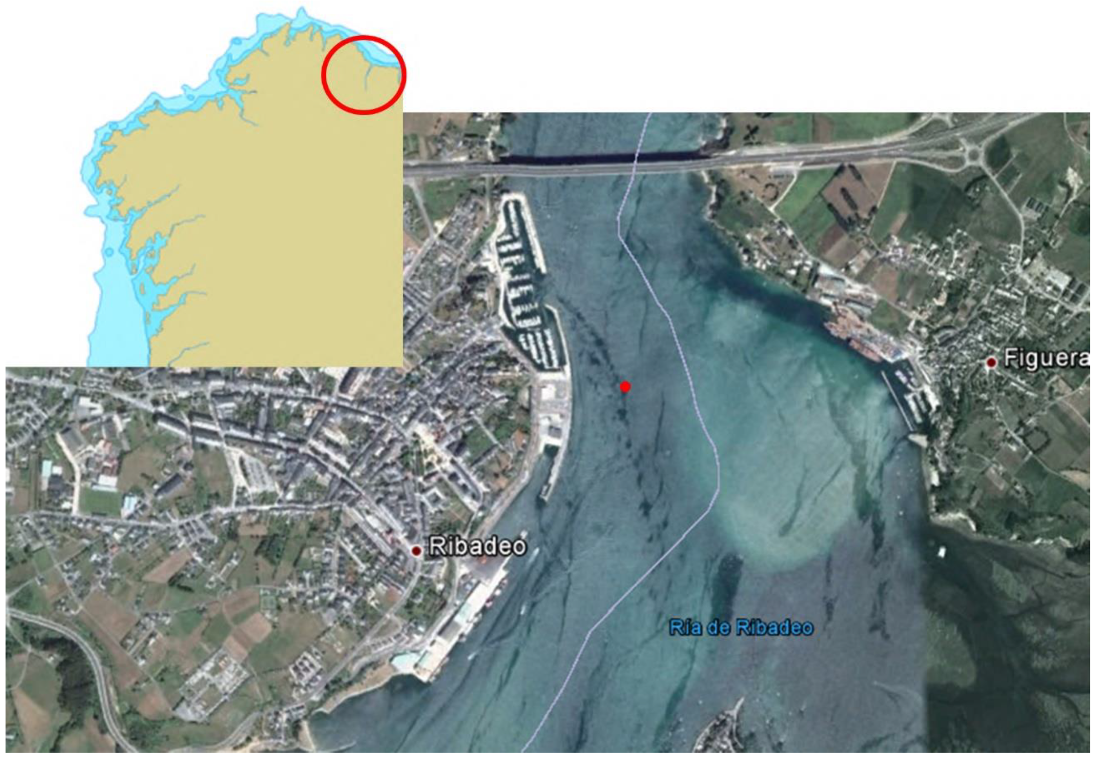
5. Discovery
Portos de Galicia is a public entity of the Galician autonomous government that manages 122 of the 128 harbors of Galicia, including Ribadeo. The Ribadeo port is located in the Eo River estuary and that poses serious sedimentation problems caused by the rise of the sea level. In combination with the tide cycle, the sea pushes sands from submerged beaches, formed in the last glacial period, towards the continent [
18]. This process forces
Portos de Galicia to carry out periodic dredging campaigns to maintain the depths that allow the passage of ships to and from commercial port.
In 2011, Portos de Galicia carried out dredging operations in the Ribadeo estuary with archaeological supervision by the general directorate of heritage from the Xunta de Galicia. Although the dredging works were carried out in an area that was previously impacted, the regional government established archaeological supervision of the dredging works, in spite of a previous intensive prospection of the area to be impacted. The archaeological survey, carried out with side scan and multibeam sonar, did not produce any noteworthy targets on the seabed. A subsequent visual survey did not yield any targets of potential historical interest either.
The dredging works began on 14 November and stopped on the 28th when the shipwreck was located.
The dredging began with the supervision of an archaeologist placed aboard a suction dredge, but the volume of water and sediment removed made it almost impossible for the archaeologist to monitor the work in real time. Inspections were conducted during dredging pauses and consisted of an analysis of the sediment in the head of the suction sleeve, in the deposits of the dredge itself, and in the area where the removed sediment was dumped.
The presence of three small lead sheet fragments, some wood fragments, and several ceramic fragments was detected twice. Lead sheeting finds are common in historic Atlantic ports. They correspond to the practice of lining the hull of wooden ships with lead to prevent an attack by shipworms and to limit the adherence of other organisms that increase the drag and reduce the ship’s speed. These lead sheets, with a thickness of approximately 1 mm, were nailed to the hull with iron nails, which were susceptible to rust and sometimes fell to the bottom. These findings were not considered important enough to stop the dredging operations. The sonographs carried out periodically did not show any significant elements on the bottom either, but despite this, it was decided to conduct a visual inspection of the dredged area on the first possible occasion.
On Tuesday, 22 November 2011, the dredge suffered a breakdown, and the planned reconnaissance of the dredged area was implemented. On 24 November, archaeologist Miguel San Claudio found several scattered fragments of shipbuilding timber, although none with any structural connection, but did not observe any other objects of archaeological interest. The absence of artifacts or connected hull structures, even at the edges of the dredging, showed that no archaeological site was impacted so far. The strength of the tidal currents made it impossible to place the origin of the scattered timber fragments.
The dredging work continued, although with greater attention given the indications that there might be a nearby archaeological site.
On 28 November, the suction pipe hit something hard on the sand bottom, and at the same time, the suction filter became clogged. The suction arm was raised to determine the cause of the malfunction. The filter was clogged with a fragment of fashioned timber and several fragments of lead sheet, as well as several fragments of limestone rock, a type of stone strange to this area.
Miguel San Claudio identified the stones as ballast of a wooden ship, with the hull lined with lead (
Figure 1). This first evidence suggested the presence of a shipwreck with a chronology between Roman and early modern times, almost certainly prior to the XVIII century. The dredging work was stopped, the position was recorded and given the late hours, a dive was scheduled for the next day.
On Tuesday, 29 November 2011, early in the morning, San Claudio confirmed the presence of the large shipwreck of an ancient vessel. It was located in the limit of the working area, at a depth of 4.60 m, very close to the limit of the planned dredging depth, which was 5 m at that point.
During this first dive, San Claudio observed that the shipwreck was preserved; over 30 m of the ship’s length was intact, and preserved artifacts were in its interior. It had not been visibly affected by the suction arm. With the overlying sand removed, the ship was recognizable in its entire length, from bow to stern and port to starboard. Complete ceramic objects were preserved on the surface of the shipwreck site. The artifacts suggested a Spanish cultural origin. In some places, part of the lead lining attached to the hull was still preserved, although much of it was detached due to the disappearance of the iron nails that held it in place.
Most of the starboard side frames protruded from the bottom, while on the port side, the protruding timbers were later identified as deck beams. Bulkheads were visible inside the hull, as well as a ballast pile. At the bow, the stem stood out as the northern limit of the wreck, while at the stern, parts of the structure could be distinguished but not clearly interpreted. All timbers appeared to be large pieces of oak, carefully worked and in an excellent state of preservation. They were held together by iron fasteners. Altogether, the hull structure showed a vessel of great robustness and considerable size.
The implementation of a good methodology of control of the dredging works facilitated the rapid detection, identification, location, and protection of the shipwreck. The protection of this shipwreck, unique in its characteristics and chronology, would have been compromised if the archaeological control of the dredging was not carried out with the appropriate methodology.
6. The Shipwreck Site
The profile of the ship was recognizable along its entire length, except for a section of the port side, which remained buried. The site exposed consisted of an area measuring approximately 40 × 20 m, where a large hull structure seemed to be buried at least 2 m deep. In the middle of the shipwreck site, a tumulus formed a ballast mound of round limestone rocks. Numerous cannonballs were visible among the ballast, along with metal concretions and 16th century ceramic fragments.
The mound of sand that covered the shipwreck was affected by the strong tidal current, which can reach three knots in the area. The sediment moves with the tidal current, covering and uncovering different areas of the shipwreck. Stratigraphy consisted of a layer of white sand with variable thickness lying over a layer formed by an organic sludge and a fine, light grey silt underneath. The condition of the wooden structure suggests that it was intermittently exposed, compromising its conservation.
The ballast was one of the most striking elements of the deposit; it comprised medium-sized limestone, 15 to 35 cm in size, located in the central part of the wreck. There were also numerous boulders of quartzite, in addition to gravel of volcanic origin. All these materials have a geological origin in the surroundings of the Gulf of Naples and the volcanic stones specifically come from the Vesuvius volcano, located very close to Castellammare di Stabia, the shipyard where Santiago de Galicia was built [
19].
Although it was impossible to secure a budget to finance the full excavation of this site and the conservation of all its artifacts, a methodology was devised for a continuous study of this shipwreck and to ensure its preservation and publication.
Santiago’s archaeological remains stand as a unique example of a Mediterranean-built warship from this period. Although technical documents on shipbuilding appear during this period, they do not describe Italian-built warships in detail. There are three Mediterranean ships studied and published from this period, namely, the shipwrecks from Villefrance—identified as
Lomellina, a Genoese ship lost in 1516—Mortella 3, a Spanish ship built in Genova and lost in Corsica in 1527, and Calvi 1, a Mediterranean ship also lost in Corsica in the second half of the 16th century [
20].
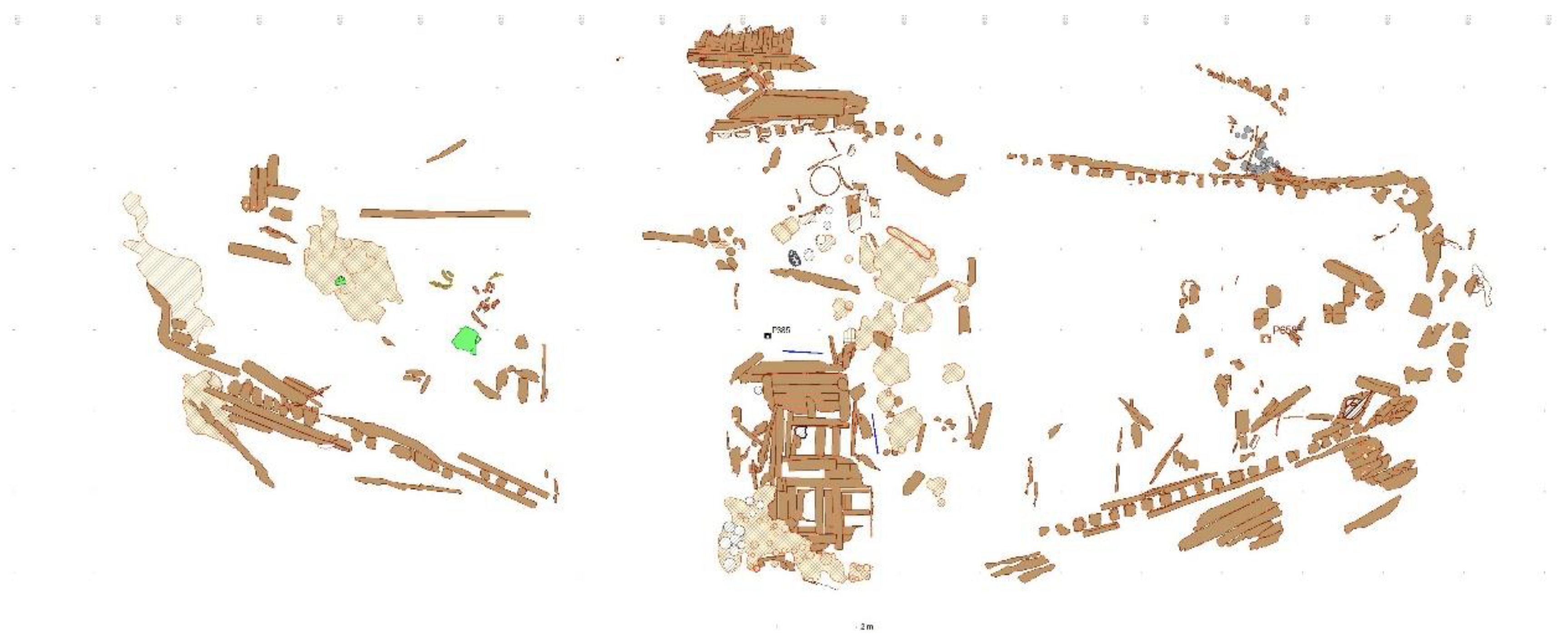
7. Methodology and Excavation
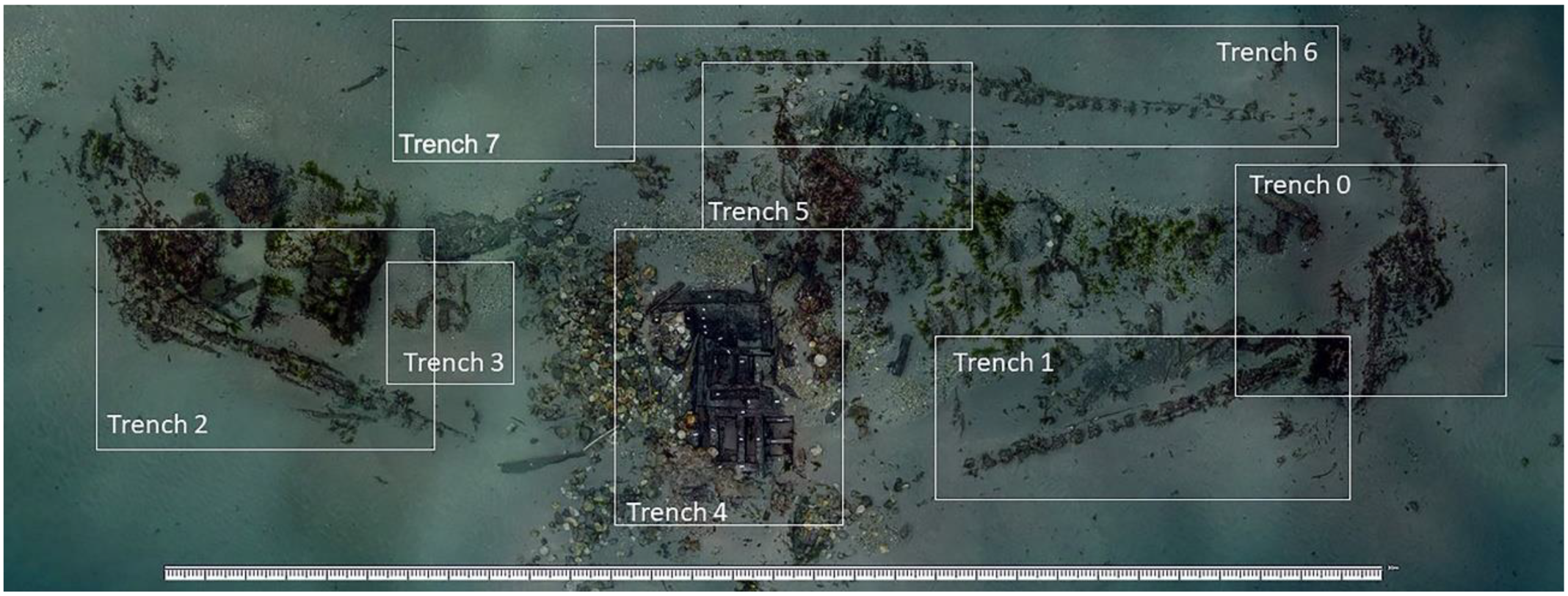
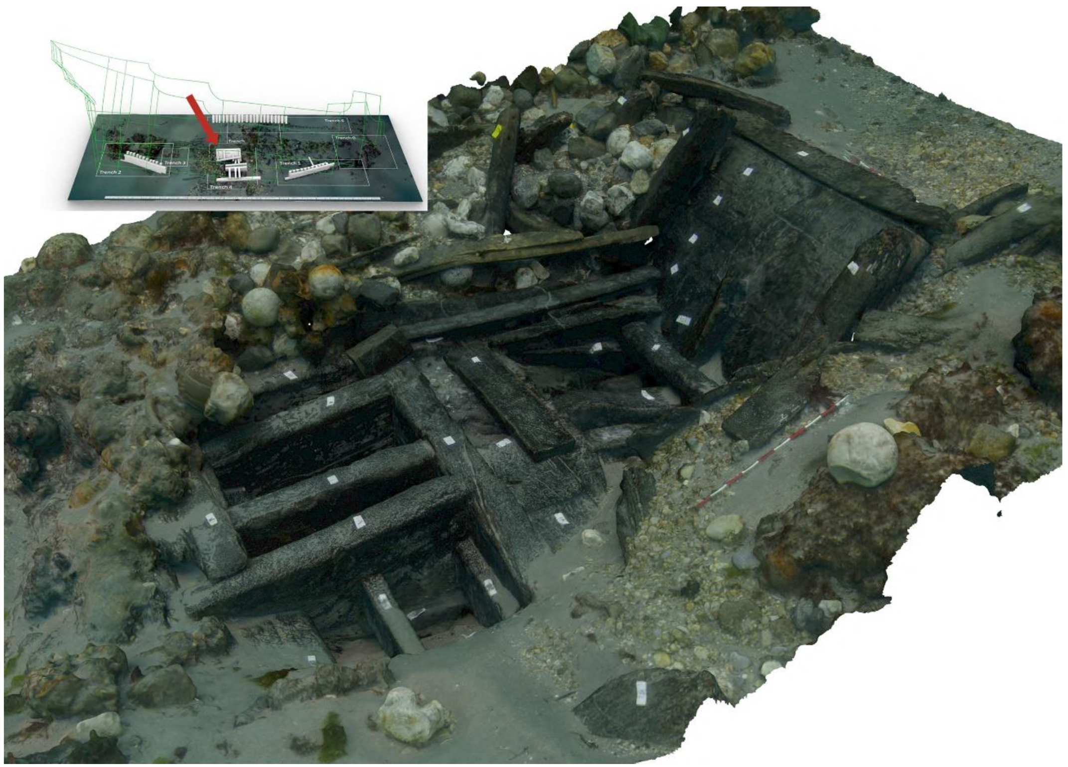
The main objective of this long-term project is to minimize intrusive work and articulate the expected results in terms of artifacts recovered with the annual budgets secured. The site was mapped with photogrammetry, and seven areas of interest were selected for trenching and study (
Figure 2).
In June 2012, Miguel San Claudio and his team revisited the site to assess its condition and establish its boundaries. A test pit was opened in the stern area and although the current and low visibility difficulted the assessment, the ship’s hull was found to be in good condition and deeply buried. San Claudio’s team also trenched in the area of the ship bow, designated as Area 0, exposing the stem, inner stem post, a breast hook, and the remains of two decks, one planked and one of baus vacios, or orlop deck. A number of samples were taken for dendrochronological analysis. After the 2012 assessment, the site was covered and protected with plastic mesh.
In February of 2015, the hull was uncovered again and the solution implemented for its protection against the sediment shift was reassessed and considered sound, producing a stable sediment mound that resisted the erosion forces. This field season was conducted within the scope of a Marie Curie grant ForSEAdiscovery, with the participation of PIs Ana Crespo and Nigel Nayling and a team from the British Maritime Archaeology Trust under the direction of Gary Momber. The main purpose of this season was the dendrochronological analysis of the hull remains, and a total of 29 samples of wood were collected from several parts of the shipwreck for dendrochronological analysis, which confirmed the identification of this ship [
21].
The site was visited again in the summer of 2018 with the support of the local and regional authorities and the Spanish Navy. The field season started with a remote sensing survey in the beginning of the year. An assessment of the shipwreck condition lasted from 11 June to 23 June. The main objective was to record the extension, depth, and preservation of the Ribadeo shipwreck. An area of the starboard framing—designated as Area 1—was inspected and sketched. Part of the ship’s hull was exposed, showing the same arrangement observed in 2012, with an outer layer of planking 15 cm thick; a line of square frames 25 cm on a side, spaced around 25 cm; and an inner layer of 15 cm thick planking. A second trench was opened in the stern area—designated as Areas 2.1. and 2.2., respectively—in the exterior and interior of the hull. The fine silt lying beneath a thin sand layer preserved a large collection of organic artifacts and made it difficult to trench, as the project had no budget for artifact conservation. A full site map was produced, and photogrammetry was used to record the structure protruding out of the sand in detail. A third test pit was opened near an area that looked rich with artifacts—designated as Area 3.
In 2019, the team carried out a trenching field season with the support from the Institute of Nautical Archaeology (INA), the Spanish Navy, and the local authorities. A 8 × 4 m trench—Area 4—was opened in the area where we believed the ship middle axis to be. The bottom structure was exposed and recorded, but again, the number of artifacts and our small conservation capacity determined that we should avoid areas rich with artifacts.
In 2020, despite all the inconveniences caused by the COVID 19 pandemic, San Claudio’s team excavated in Trench 6 and opened a new Trench 7, where they discovered a line of vertical protruding timbers integrated in a deck that pointed towards an outer line of frames attached to the hull. Our hypothesis is that this was the main deck, the lowest artillery deck of the galleon, conserved along the port side. A gun carriage was found on this deck, which seems to be preserved along a considerable length. This deck is caulked and covered with pitch.
The sediment that covers this area of the shipwreck prevented the team from advancing beyond a set of barrels, located under the main deck, which was buried into the area of the main deck. In the same Trench 7, San Claudio’s team documented four orlop beams, or baos vacíos, which suggested that there was a considerable depth of untouched stratigraphy preserved.
In 2021, the team concentrated on Trench 6, which consists of a line of the ship’s starboard planking with protruding futtocks, presumably 2nd and 3rd futtocks, and part of the deck structure, presumably the gun deck structure.
In 2022, the team focused on consolidating the 3D image of the ship’s hull and the artifact inventory.
8. Analysis
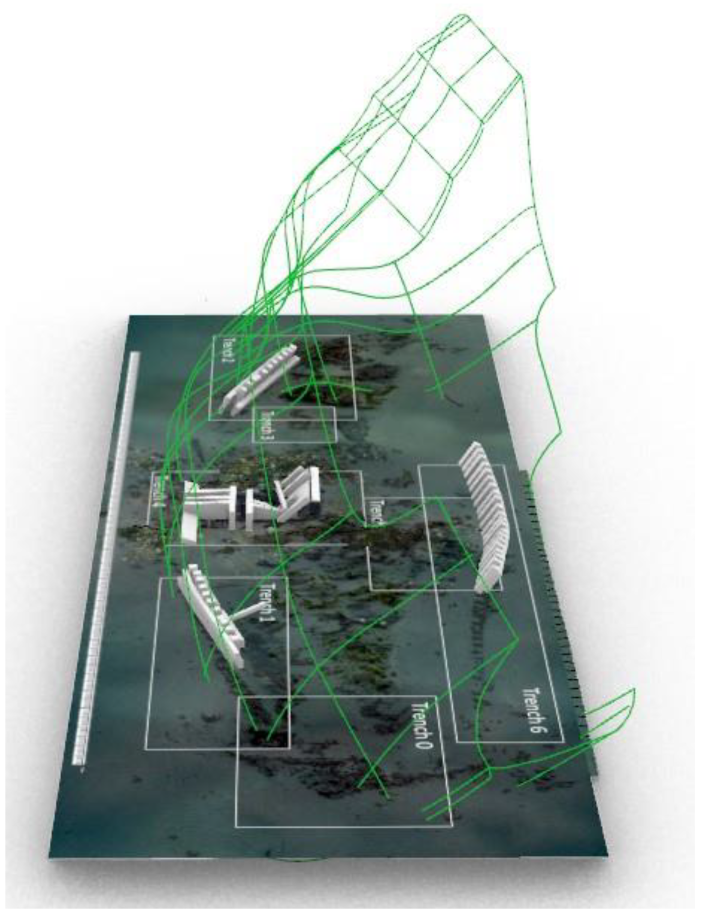
The ship’s hull remains are preserved over a large area and may encompass a large portion of the port side, conserved far above the waterline, probably up to the lower gun ports (
Figure 3). The information accumulated over the last seven excavation seasons is presented below, organized by areas.
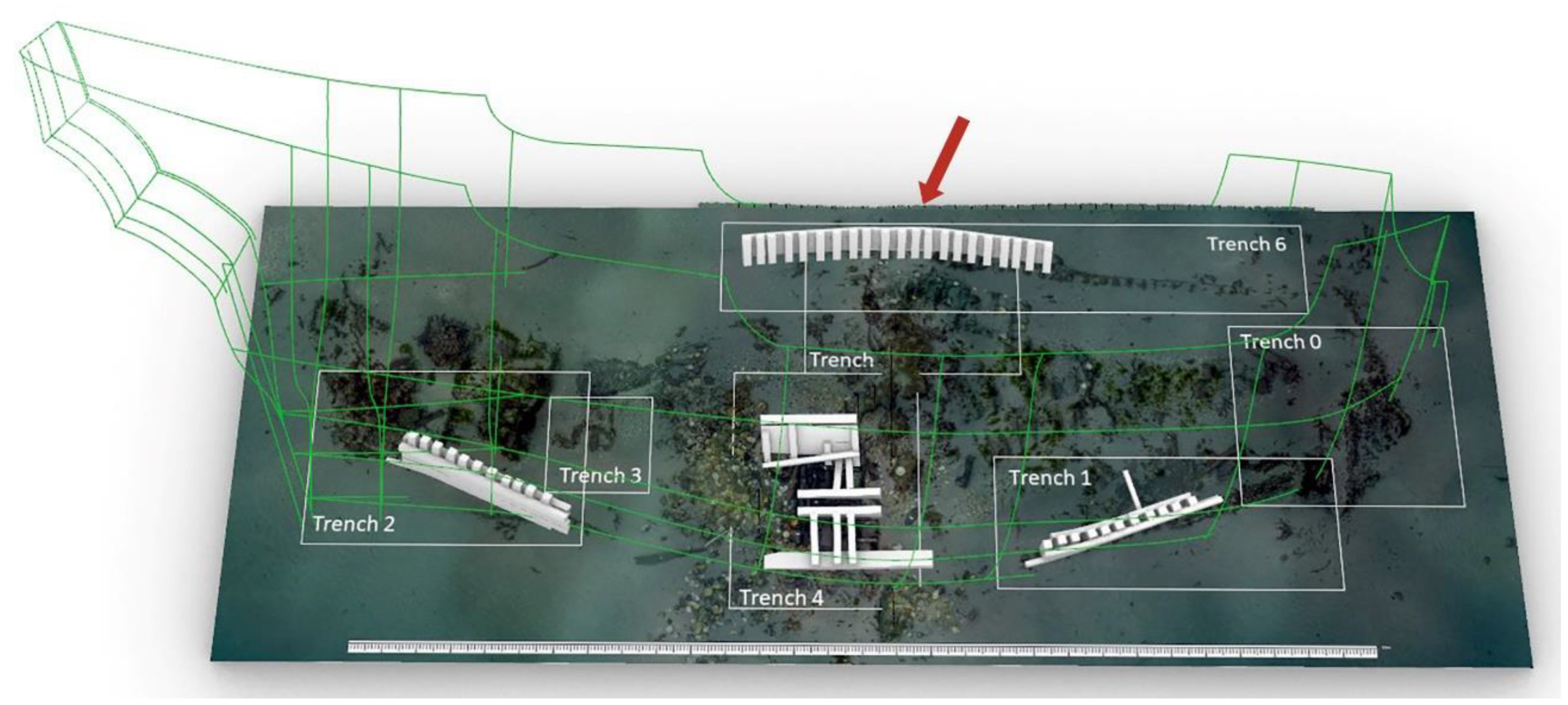
Site Plan
The site lies 4.5 m deep, and its plan is a work in progress, and we are currently planning a way to develop a 3D model of the parts recorded. The shipwreck covers an area of approximately 20 × 40 m, aligned on a north–south axis and listing to port side, with the bow pointing north and downstream, suggesting that the ship was beached during the incoming tide. The bottom of the hull is preserved with an impressive collection of artifacts inside (
Figure 3).
The absence of anchors and guns is consistent with the salvage operations that followed the abandonment of the ship’s hull. The site’s location in the shallow water and away from the anchorage was also the result of a deliberate effort to facilitate the recovery of the ship’s cargo, weapons, and fittings.
The study and recording of this site focus on separate areas, as indicated above, which we are trying to record in detail through an iterative process (
Figure 4).
So far, we can affirm that the ship was built with oak timber from the region around Naples and other supply areas, probably in the vicinity of today’s Albania, which ongoing dendrochronological analysis will help us discover. The timbers were fastened with iron nails with square shanks and completely lined with lead sheath below the waterline.
Trench 0
Located at the ship’s bow and trenched over an area of approximately 4 × 4 m, Area 0 contains the remains of the ship’s stem, standing upright, with a slight list to port side. The exposed part of the stem was made of a single piece, lined with lead on the planks still attached. A garboard was carved along the stem, receiving the hoods of the hull planks. The inner stem post was attached to the stem. It was not possible to observe the connection of the stem to the keel.
The remains of two decks were observed, the first located at the forward end, fitted into the inner stempost, and sitting directly on a breast hook. This breast hook was notched to fit the inner stempost and connected the starboard and port clamps, also notched on the upper face to receive the deck beams and on the outboard face to fit over the frames. The deck beam sections were around 20 to 25 cm square, and the distance between them ranged from 28 to 33 cm. Numerous cannonballs were found on this deck, which was found to be caulked and covered with pitch. Another portion of the deck was observed on the port side. It was collapsed but preserved with the beams that supported it. Part of a bulkhead was also preserved on this deck. This bulkhead divided two compartments, one with barrels and another with stone cannon balls. Along the port side, some horizontal strakes seem to suggest that they were also part of a deck. These remains may have belonged to the main deck of the ship. No traces of a waterway were observed.
There were no gaps between the frames in this area. Along the starboard side, several strakes were still connected to the frames. Some hull strakes were displaced, fallen after the fasteners, in iron, corroded away. The hull was 55 cm thick with an outer layer of planking 15 cm thick, a line of square frames 25 cm on a side, and an inner layer of 15 cm thick planking.
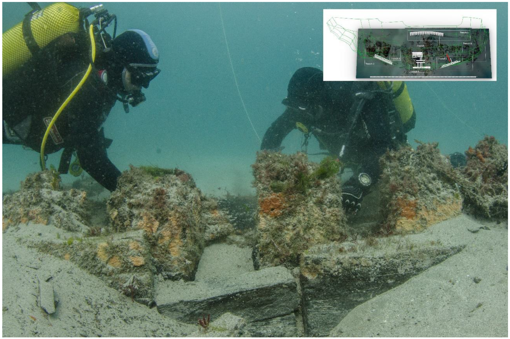
Trench 1
Trench 1 is a section of the protruding starboard hull, extending along 10 × 3 m, with an area of planking laying to the outside, separated after the corrosion of the iron fasteners. Its dimensions are consistent with other measurements made along the ship’s remains: an outer layer of planking 15 cm thick, a line of square frames 25 cm on a side, and an inner layer of 15 cm thick planking (
Figure 5).
The planks were fastened with two or three iron nails per frame. The hoods inspected had two nail holes.
Some features observed in this area require further observation, such as evenly spaced holes in the ceiling whose function is not yet understood.
Trench 2
Trench 2 is complex and was surveyed over approximately 8 × 4 m. It is composed of collapsed timbers and a part of the ship’s hull lined with lead on the outer face (
Figure 6). For commodity, we have separated it into an inner and an outer area, which we designated, respectively, as 2.1. and 2.2. sub-areas. Below a thin layer of white sand, the timbers are embedded in a thick and fine grey silt that has preserved a plethora of artifacts and that makes it difficult to excavate with a supporting conservation team and laboratory.
The frame timbers form a wall with no spaces between them and are not square with the planking. Only further research will allow us to interpret this part of the structure.
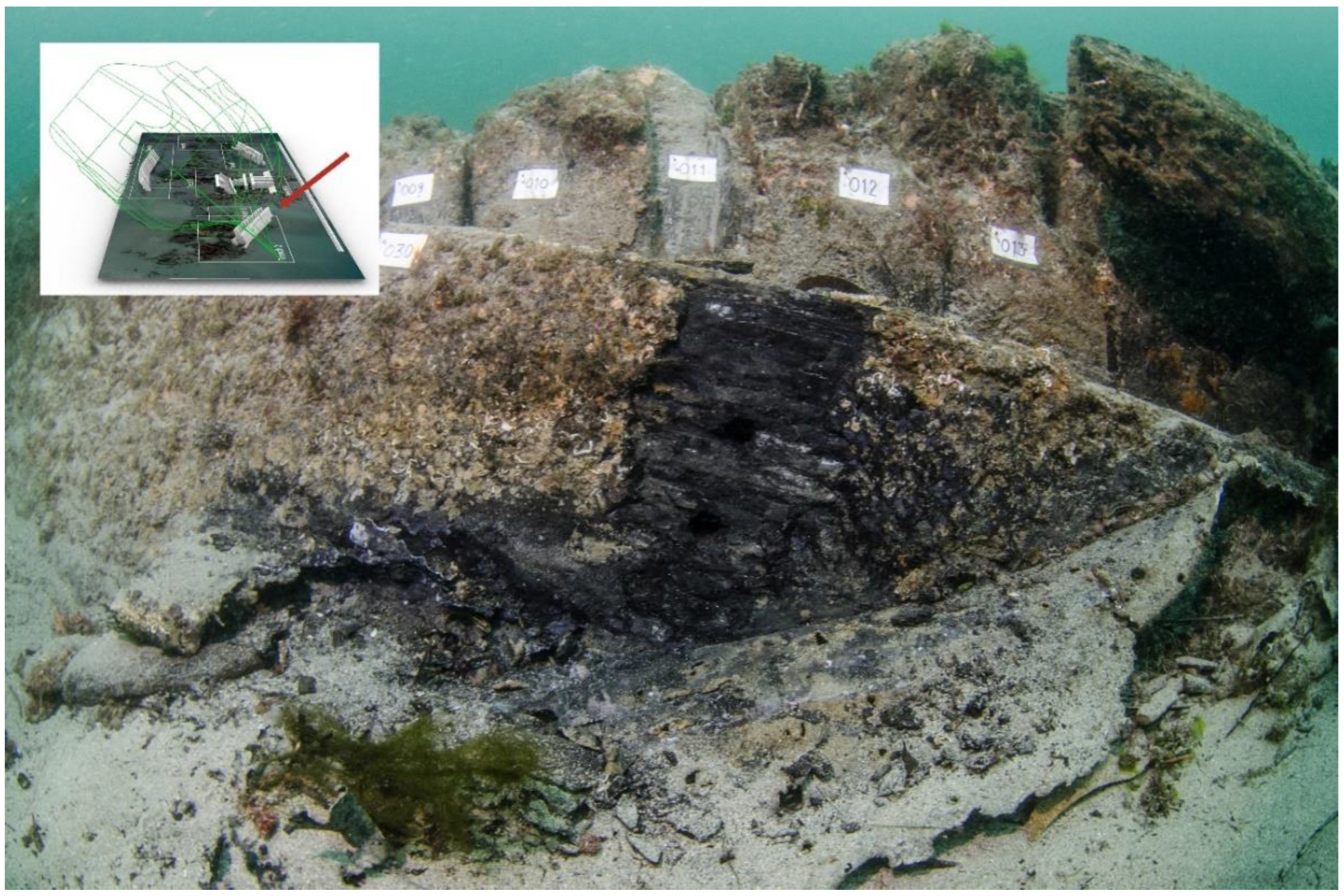
Trench 3
Several balusters made of turned wood were located in this area, between the central ballast pile and the stern (
Figure 7). Its use on board is varied, probably on stairs, tables, coamings, or as ornamentation in galleries in the stern. Associated, a chestnut wood prop was located that we identified as the axis of a staircase whose balusters would be arranged in a spiral around it.
Trench 4
On the surface, Trench 4 was a central ballast pile contained by two heavy bulkheads separated 2.90 or 3.50 m from each other. The ballast is composed of round stones with diameters between 15 and 30 cm, which include large stone cannonballs, almost certainly not meant for the guns of
Santiago’s battery. Upon removal of the ballast pile, which formed a layer of approximately 1.50 m, we found the upper layer of the ship’s bottom timbers (
Figure 8).
The mast step Trench is complex and deep, and only its full excavation will reveal its arrangement and dimensions, including the nearby midship frame. The site has been only partially excavated and recorded and has revealed a complex system composed of two sister keelsons, an unknown number of buttresses standing on bilge stringers running to port and starboard, and other timbers used to reinforce this area that have yet to be understood. Underneath the buttresses lie the floor timbers and first futtocks, as well as the outer, bottom planking, 15 cm thick, as observed elsewhere, in Trenches 0, 1, and 2.
According to certain, non-peer-reviewed sources, the use of mortar as fixed ballast is referenced in the
San Diego shipwreck (1600), in the
San Martin (1618), and in the
Atocha (1622). This use is also referred to in the
Santa Margarida (1622), but no details are given, and the bottom of this ship is not referred to in its publications [
22].
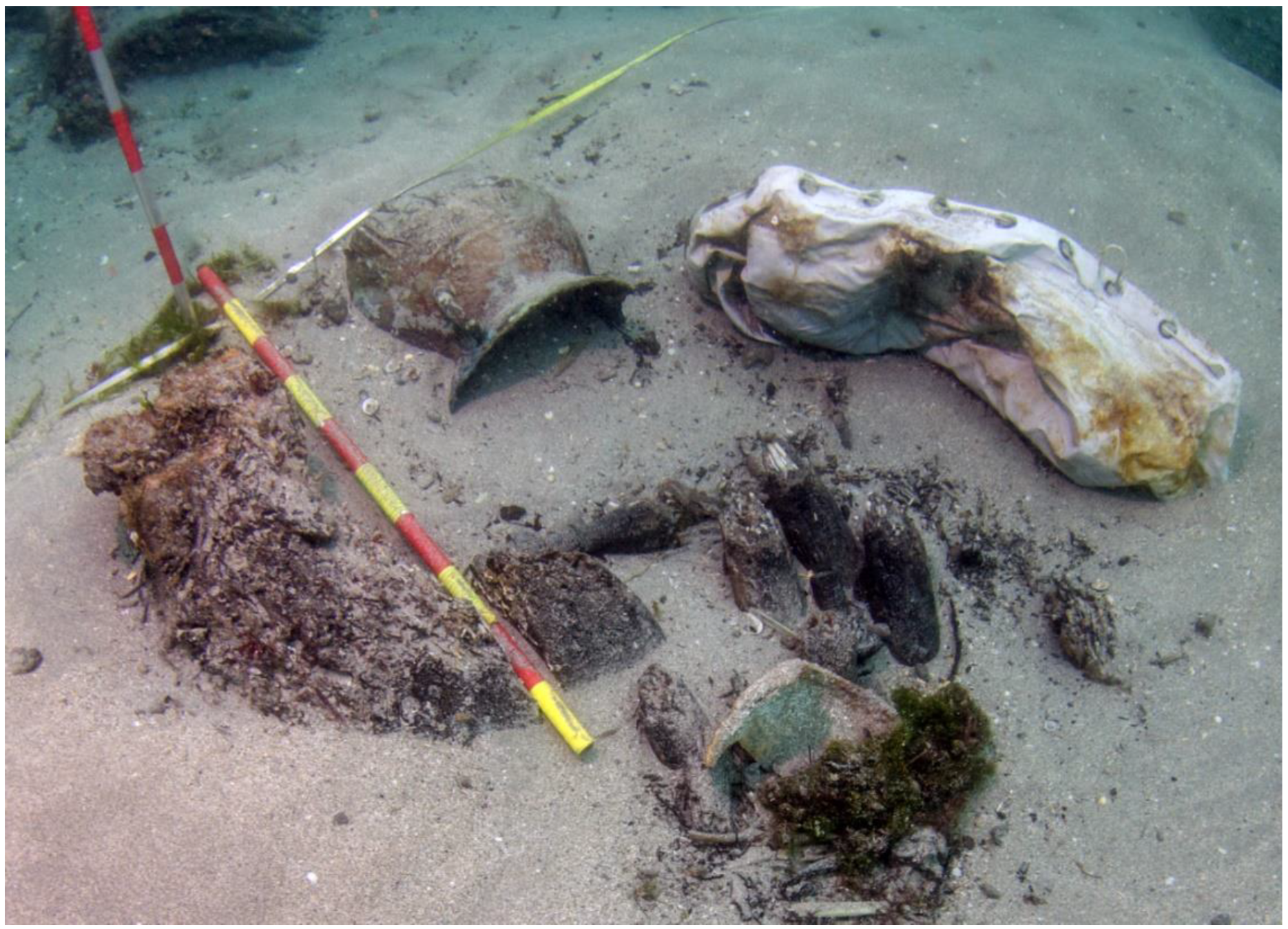
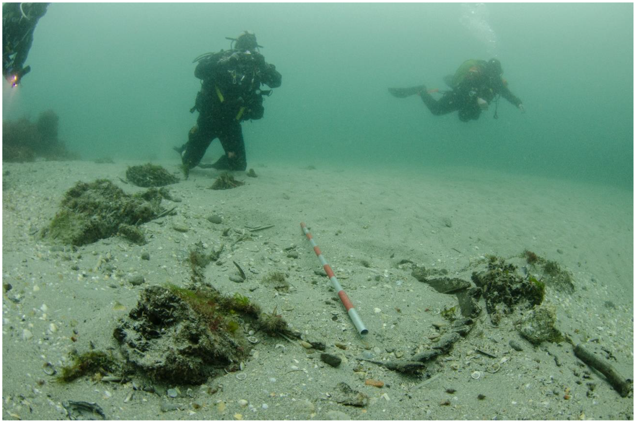
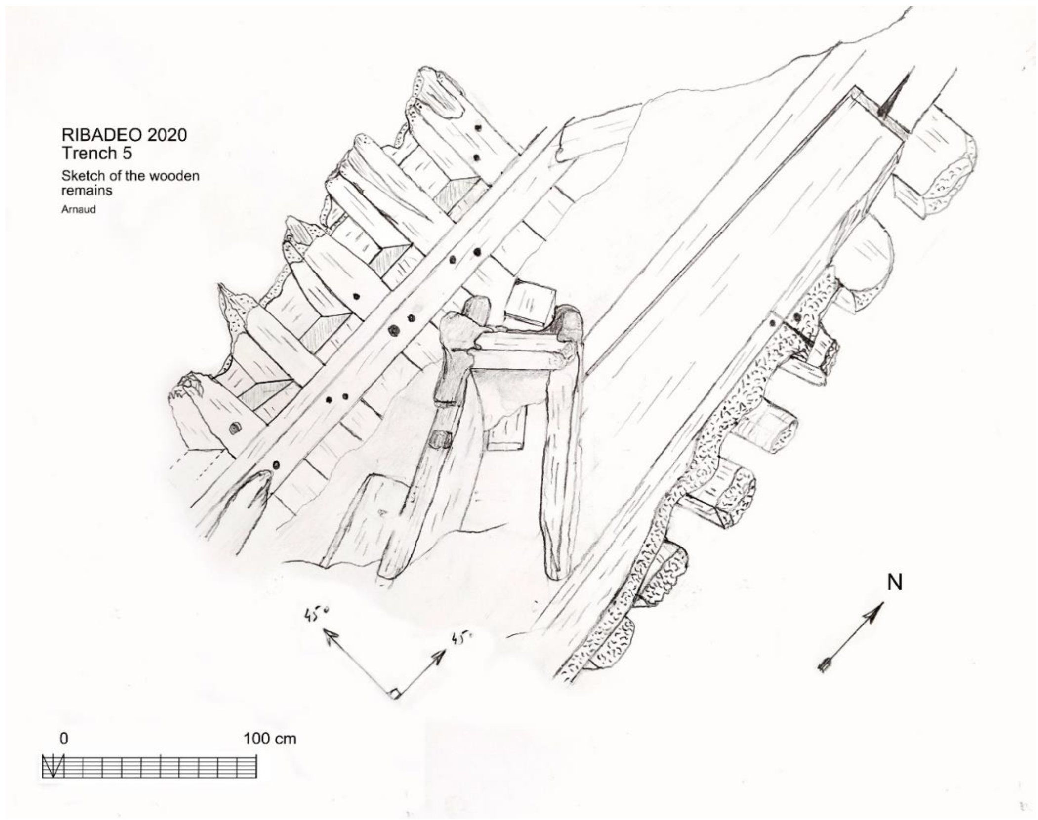
Trench 5
This Trench is located forward of midships and has only been trenched over 3 × 3 m to assess the density of artifacts packed under the sediment. A series of barrel staves were observed, together with a wooden sheave, rope, and ceramic shards (
Figure 9).
Trench 6
This Trench is the ship port side hull and the remains of a deck (
Figure 10). It extends over 20 × 3 m and shows a line of protruding timbers that present similar scantlings as those observed in Trenches 1 and 2. It reinforces our conclusion that this was a warship built with extremely strong upper works, measuring 55 cm in thickness when we add the outer planking to the frame timbers and the inner planking.
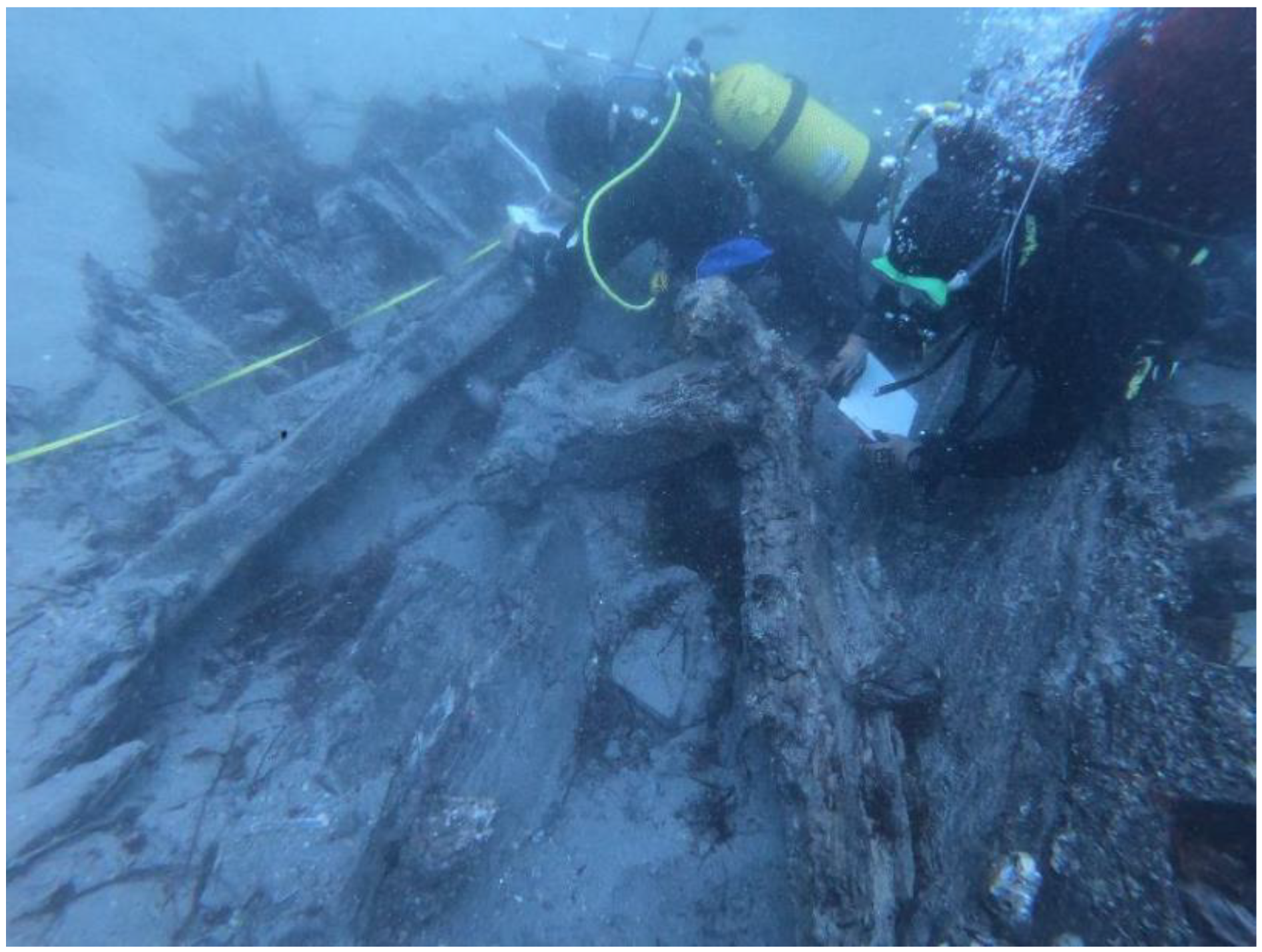
Trench 7
Trench 7 is a section of Trench 6 opened in 2021. It is a part of the ship’s portside that, in 2020, revealed part of the upper hull structure protruding from the sediment surface and part of the upper deck. This area promises to yield more information in future seasons, namely, the arrangement of the deck supporting structure with clamps and waterways (
Figure 11 and
Figure 12).
Scantlings
The ship scantlings are robust, as should be expected for a warship. The known dimensions of the main timbers are indicated below, in
Table 4. A lot of work remains to be done in this area, as the timbers exposed in the trenches opened so far have not exposed samples of all the main structural timbers of this ship.
9. Conclusions
The ship shape is impossible to reconstruct at this stage, based on the archaeological information, but we know the ship’s project dimensions [
2]. Furthermore, on 28 September 1595, the ship was inspected in Lisbon by Antonio de Urquiola and awarded 1349 tons and 138 crew seamen. In the “
Relation of the ships that were in the Army of His Majesty and the tons that they have and the supplies that each one carried”, only 1200 tons are attributed to it. The ship project dimensions are indicated above, in
Table 1.
We consulted our friend and specialist Cayetano Hormaechea in the reconstruction of the hull and obtained a form of the lower hull that is plausible and easy to model (Hormaechea personal communication). We are working on this reconstruction and intend to complete it with future input from the next excavation seasons.
The ongoing task of studying this ship is immense, given the patrimonial and scientific wealth that it preserves. With carefully planned work and adequate diving techniques, it is possible to undertake this study with an economy of means and contained costs. Even if they develop at a slow pace, the results from the scientific and patrimonial points of view are relevant and justify this project, as demonstrated by the successive campaigns carried out so far.
We have before us the magnificently preserved remains of a ship built in the Mediterranean with an oak structure, complemented with different tree species, as indicated in [
21]. The presence of a material culture of Iberian origin stands out, even though we know that the ship was built in Italy. The Habsburg King of Spain ruled over a wide range of cultures and territories and even though the excavation team has been avoiding the areas of the ship more cluttered with artifacts for budgetary reasons,
Santiago de Galicia presents a variety of artifacts built, armed, and manned by a cosmopolitan group of individuals.
A question remaining pertains to the extension of the preservation of the ship remains. It is difficult to have an a priori accurate prevision of the remains that are still preserved under the sand. However, we do have indirect evidence that provides an idea. The shipwreck is probably preserved in its original layout and mostly in connection. The ship’s frames protrude vertically from the seabed, and this implies that the frames were not displaced, as is generally the case after a shipwreck. With the exception of the maststep area, where the remains extend only a few meters to starboard of the keel, the data obtained so far suggest that we are generally in the vicinity of the ship’s waterline, with the exception of the port side, where we appear to be well above the waterline, although this side is detached above the first deck.
The width of the shipwreck remains suggests that a substantial part of the hull is still buried under the sand to port side, specifically, the whole of the bilge and flat, or plan, of the ship, together with a portion of the hull above the waterline.
In sum, what we know for sure is that the Ribadeo galleon was built in the Kingdom of Naples, a constituent part of the Spanish Empire until 1713. Its captain and owner, Giovanni di Polo, assisted in its construction at Castellammare de Stabia, directed by master Colela Bonifacio, a native of Naples. La Almiranta de Ivella, the second ship in command of the fleet, as it was also known, was one of 12 galleons of the Illyrian Squadron of Pedro de Ivella.
It was launched in 1590. It was a large ship for its time: 33.43 m long and approximately 11.42 m wide. On 28 September 1595, in Lisbon, the ship capacity was estimated at 1349 tons. A crew of 138 and two companies of soldiers boarded for Ferrol and the planned invasion of England. Although it is unlikely, we cannot exclude the possibility that this ship was equipped with sweeps for propulsion in maneuvering situations. There is a record for the payment of 5612 maravedis for 4 oars, for the galleon’s use, which could be destined for an auxiliary boat or be intended as sweeps for the ship’s maneuver.
We know that Santiago de Galicia was designated to transport most of the money shipped to cover the cost of the expedition, something that speaks to its reliability as a ship. Initially it carried 28 pieces of artillery, but at Lisbon only 16 pieces of them, all of bronze, are mentioned, all property of its owner, and made at a Genoese foundry.
After an active life of seven years, Santiago de Galicia ran aground at Ribadeo and was unloaded and partially dismantled in 1597. Its remains are the object of this paper and the parts that were uncovered so far suggest a strong and well-built warship. As already mentioned, because of budget restrictions, the team researching this shipwreck site was forced to trench across the site and interpret and reconstruct what was recorded without generating a large collection of artifacts that would have to be conserved, stored, and curated. The situation of the deposit is delicate, and the ship’s long-term conservation is complicated.
10. Discussion
In this paper we present a hypothetical reconstruction of the vessel intended to guide the research and invite other scholars to give us their opinions and hints. We expect this project to continue at a slow pace, dependent on the budget, until we have a grant and a place to house the conserved artifacts and share them with the public. As we present here a first description of the hull remains, we want to clarify that we are using a methodology that aims at an iterative approach to the ship reconstruction. Too many projects never saw a final publication because their investigating teams aimed at finishing all the work before sharing it with the rest of the world. We believe that archaeology is an iterative process and that it is better to share the information as we have it and look for the input of our peers.
As a result, this paper is purposely lacking some assumptions. We believe that our methodology, which consists of adopting a plausible hypothesis for the size and shape of the hull and hanging the structural information available on these hypothetical line drawings, will allow the community of interested archaeologists to comment, criticize, and thus, participate in the process of unveiling this interesting shipwreck and propose plausible reconstructions.


