Abstract
The proposed work deals with the generative process of high-resolution 360° spherical photographs for the creation of an information container in the form of a virtual tour for the immersive fruition of the archaeological area of Abellinum. The development of the tool aims at the promotion and dissemination of the research results obtained so far within the project “Abellinum. Piano per la conoscenza, la tutela e la valorizzazione dell’antico centro irpino”, as well as a first expeditious approach for the digitisation of an area that is still difficult to access. This procedure, born out of a health emergency but also an economic-social one, acts as a suitable and valid alternative to more time-consuming methodologies, imposing a reflection on the resources to be deployed in relation to the purposes of the cultural offer. After describing the technical approach enacted, the study of the virtual tour interface design and the basic functions adopted in this first phase are investigated, hinting at possible implementations. What emerges is a progressive transdisciplinary enhancement between academic and professional skills for the promotion and preservation of cultural heritage, with the development of new tools and the transformation of existing ones on the basis of a technological process that is in its full rise.
1. Introduction
In recent years, the process of digitisation of cultural heritage (CH) is increasingly motivated by the impact and diffusion that new information technologies are having on historical spaces [1], driving experiences of more fluid and shared knowledge [2]. In addition, since cultural life has moved online, virtual reality (VR) applications are increasingly being used for both educational and recreational purposes [3].
This implies that, if the current trend is to combine the ethical responsibility towards posterity (knowledge and preservation) with the need to ensure a more democratic diffusion of assets (dissemination) [4], it is today a hard challenge to find an approach that meets demand on a large scale. On the one hand, the specialised community needs the generation of an integrated heterogeneous database, widely accessible, shareable, and implementable over time [5], especially with respect to natural disasters, destruction by war, neglect, and inappropriate storage; on the other hand, the wider public requires a dynamic fruition of the CH, in which the visitor expects the visual and sensory transmission of scientific results [6], actively participating in the cultural offer and establishing a positive dialectical contact. In fact, especially in the current scenario, regarding the recent medical emergency linked to the spread of COVID-19, significant changes in the practical side of our lives have undoubtedly influenced the use of heritage spaces, causing a loss of cultural experiences [7]. This has highlighted the synergy between different disciplines, such as education, training, and entertainment, the so-called “edutainment”, leading to the creation of attention-grabbing applications.
In this context, a large amount of data has to be stored and then disseminated agilely and efficiently—an issue that is among the central activities of the decision-making process for heritage management [8] due to different natural characteristics, different sizes, and complicated structure of the heritage sites [9]. The CH digitisation challenges have been successfully pursued for several years by advanced surveying technologies for the creation of three-dimensional models that precisely reproduce and reconstruct the real settings, such as photogrammetry and laser scanning [10,11,12], according to techniques that are well established and continuously improved [13]. However, in relation to data storage and dissemination, the methodology chosen should be appropriate for the scope of the project, the timeline, and budget constraints [14,15]. Thus, from a cost-benefit point of view, it would be opportune to identify intermediate solutions, configuring a fast survey approach joined with the descriptive-immersive nature of the representation [12]. Trying to find a compromise between all these different factors that characterise heritage digitisation approaches1, it is possible to observe how innovations in digital imaging and in particular the development of stitching algorithms have expanded the possibilities of a specific type of photography, 360° photography, making it possible to combine multiple images for a digital three-dimensional enjoyment of space from a two-dimensional datum, saving in both data storage and management time of the acquired material. This was intuited and commercialised by Google’s Street View application back in 2007, providing mobile and desktop customers with a virtual reality environment in which users can virtually explore streets and cities [18]. Therefore, discussing 360° photography is nothing new. Nevertheless, since this service does not provide specific information on the sites, what is new is the way in which 360° photography can be exploited today in relation to VR applications for the remote-scientific-content-based knowledge of sites, and certainly also archaeological sites. In this regard, the case here presented constitutes an attempt to bring the community’s attention back to an archaeological site with one of the most expeditious and popular tool, the photographic one, generating, in the limited time available and with relatively low-cost equipment, a sequence of 360° interactive photos, i.e., a virtual tour, that acts as a starting information container2. In this way, even before the phase of three-dimensional modelling and environment reconstruction, it would be possible to proceed to a preliminary and rapid digitisation of the asset on the basis of immersive photographic visualisation. The intention is therefore to create a VR application that allows scholars to describe and share the spaces brought to light by the excavations and at the same time can capture the public’s attention on this area even before it is musealised and thus opened to the visitors.
It should be noted, in fact, that the issue becomes more relevant for spaces not yet involved in musealisation processes (or who for several reasons will never be involved), such as in the case of archaeological sites, where the opening to the public is partial or reduced even in pre-pandemic conditions. In fact, as well as museums, archaeological sites which have not yet achieved a museum configuration also play the role of central actors in promoting lifelong learning and the dissemination of the values on which humanity is based [19]. However, they could stand on the side-lines: sometimes the excavation may remain unpublished for a long time, whereas other times the most important finds it contains may often be separated from the site of origin and exhibited in more prestigious locations, losing connection with the native environment.
At a glance, the fragmentation of the identity lowers community interest in the site and postpones future investments, often leaving archaeological areas only partially excavated. Therefore, this virtual experience, as an active tool, represents a way to involve a contemporary community no longer content to observe in silence the heritage spaces but that wants to be part of it in the first person, with this being what determines the strong educational, social, and financial impact the CH needs today [20].
It is hoped that the preliminary operations carried out in this survey and VR documentation campaign will be a catalyst for promoting preservation, valorisation, and regeneration programs, as well as addressing important historical and archaeological issues that are still unresolved and not widely known for one of the several cultural areas in our country.
2. Case Study
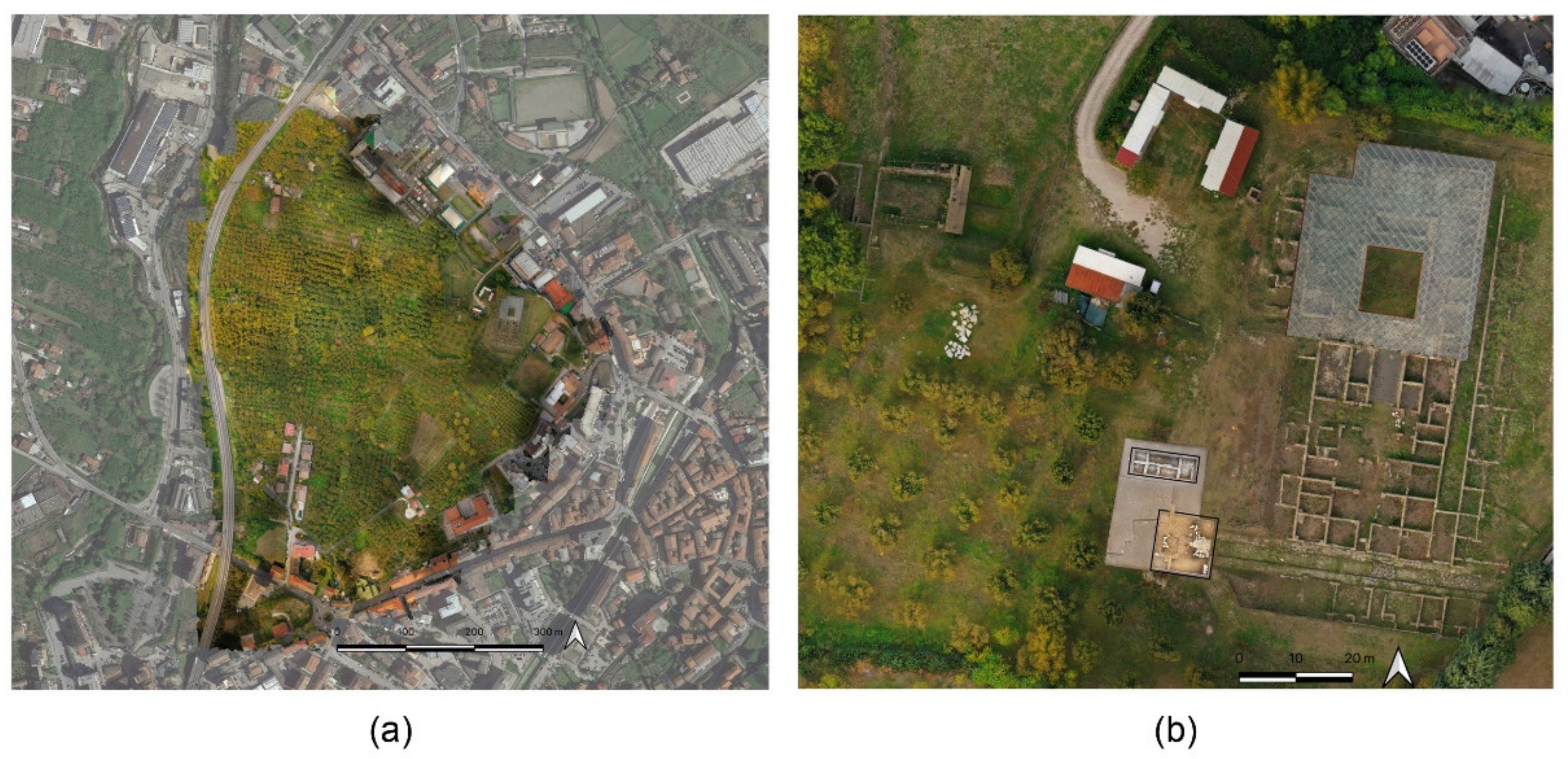
The VR applications have recently been carried out as part of the “Abellinum. Piano per la conoscenza, la tutela e la valorizzazione dell’antico centro irpino” project3, with the aim of expanding the knowledge base on the ancient city of Abellinum (Atripalda, Province of Avellino, Campania Region, Italy) starting from the current urban tissue in which the archaeological area (in the Civita locality) is located [21]. Currently, the virtualisation is focused on a small part of the archaeological area, the so-called domus area, while waiting for excavations to continue and bring to light the still-buried structures of the ancient settlement. In fact, it is currently possible to appreciate only the vestiges of road and terracing infrastructures, defensive structures, and a domus located in the north-eastern portion of the original site (Figure 1). The entire ancient settlement stretched across the plateau of the Civita, an area of 25 hectares overlooking the Sabato river. The plateau is protected by a defensive system: at the end of the 4th and the beginning of the 3rd century B.C., the walls were made of opus quadratum of tufa blocks; then, in the first half of the 1st century B.C., a new fortification in opus reticulatum was built, about 2 km long, with a moat in front and defensive towers [22,23].

Figure 1.
(a) Atripalda: orthomosaic of the Civita plateau (M. Limongiello, DICIV) placed in the context of the present-day city (from Google Earth). (b) View of the archaeological area: the termae (to the west), the domus (to the east), and the decumanus and the tabernae (to the south). In the centre, the new excavations of the “Abellinum” project.
Although the oldest frequentations date back to the Protohistoric age, there are traces of an early settlement from the Samnite period, and later the settlement took on an organic structure, starting from the 1st century B.C. and assumed the physiognomy that can still be observed today. At that historical moment, the construction of the city’s main monuments took place: a public area was supposed to be in the centre of the plateau, largely damaged by a modern quarry for the extraction of tuff (Cava Guanci).
To the west, other buildings and a north-south cardo are known from excavations in the 1970s–1980s and are no longer visible. To the east, beyond the structures attributed to a thermal building, are the main monuments of the archaeological area. They are arranged along the decumanus, an east-west road axis that remained in use until the last stages of the city’s life, probably in the 6th–7th centuries A.D. It was overlooked by rooms that have been recognised as tabernae. To the north, the space of an entire block is occupied by a domus, the subject of VR applications. This building was chosen as a case study to assess the potential for interaction between a rapid acquisition, aiming to generate the virtual experience, and the detailed archaeological analysis of the monument4.
It is a rich mansion which belonged to M. Vipsanius Primigenius, Agrippa’s libertus. It was built on previous residential units and was developed with progressive extensions over a large area until it faced north, towards the river valley: it took on the characteristics of the so-called a terrazza (terraced) houses from the Augustan age and throughout the imperial age [24].
The domus is articulated on the succession of atrium and peristyle, with the entrance on the south side, and the rooms respond to a functional distribution. The entrance (vestibule and tetrastyle atrium) leads to the living and representation area, characterised by the tablinum and the peristyle, with a natatio, a kind of small pool. On this porticoed space, there are rooms (oeci) frescoed with a varied decorative pattern; triclinia and two cubicula are found close the northern edge of the house.
The domus survived until the 3rd century AD and underwent restorations and reconstruction [25]; from the 4th century onwards, also as a result of seismic events (an earthquake in 346 A.D.), only the southern areas, which continued to gravitate along the axis of the decumanus, were progressively used throughout the Late Antique period and until their final abandonment.
The street, with cardines identified to the east and west of the domus (this one emerged from recent excavations), defines the space of a block: the projections of the road axes on the entire plateau, plotted on the basis of metric analyses, make it possible to hypothetically reconstruct the urban grid of the entire settlement.
In addition, recent excavations, conducted in 2021, have increased knowledge of the west area of the domus. The decumanus continues for another 10 m with buildings facing the street, both on the south and north sides, and the structures, such as the domus and tabernae, have signs of maintenance and restoration works over time. Traces of further still buried constructions emerge from geophysical surveys and suggest a regular occupation of the area, hinging on a recently identified intersection between the decumanus and the cardo.
The amount of data collected within the project led to the creation of a dynamic archaeological map of the ancient city and an integrated knowledge system aimed at enhancing the context, perceived as a cultural ecosystem. The historical data are thus related to the vegetation and environmental survey, geomorphological analysis, and topographical study for a reconstruction of the ancient landscape—a corpus of knowledge that can be communicated and enjoyed with agility through the use of new technologies, both by expert users and by the general public, and above all by people who live in the proximity of the site and who can benefit and advantage from these places in terms of knowledge, culture, and ultimately quality of life. The creation of a cultural ecosystem strengthens links with local origins and roots, as indicated by the Council of Europe (Faro Convention) on research and preservation of historical memory5. This is a well-established approach of public archaeology, or rather of community archaeology [26,27]—through the sharing and dissemination of data, the aim is to create involvement and active participation using the concepts and tools of open science and smart culture.
In this perspective, the creation of immersive experience applications is proposed as a valuable support for the transmission of knowledge and the enhancement of archaeological and cultural heritage.
3. The Recent Rediscovery of Immersive Experiences
After an examination of the wide range of tools that could possibly be employed, the formulation of a time- and cost-efficient solution in response to the need to digitise the domus area, going beyond traditional 3D modelling techniques, emerged. The workflow is based on the principles of nodal photography and, more generally, on the principles of a particular type of anamorphic projection, known as “equirectangular”, which allows the production of images with a visual angle of 360°. In this configuration, the modelled 3D space consists of a spherical surface at the centre of which the observer is placed: from this point, the user will interact with a virtualised real space, usable even from a remote location [28].
The intention to artificially reproduce the world around us, acting on the relative perspective perception, is documented long before the advent of photography. In fact, from the earliest epochs, the representation of space has constituted a necessity, a way of orientation, of recognising places and of appreciating their dimensions and shapes [29]. We have to wait, however, until the end of the 18th century to speak of a “panorama”, obviously a pictorial one, mainly aimed at popular entertainment. Unfortunately, that trend was soon overtaken with the advent of cinematography and nostalgically revived with the diffusion of photography and the development of wide-angle lenses in the mid-19th century. It is only with the digital revolution and its unexpected fallout that this wave has been revived: during the middle of the last century, a certain ferment was already being re-observed around the idea of being able to enjoy an interactive representation of space, rethinking the way of proposing the image vision: it does not move in front of the spectator, but it is the spectator who moves within it [30]. Thus, around the 1980s, the idea of a virtual space, recalling visual space, uninterrupted, without limits, implying that the world continues beyond the edge of the frame, returned to the mainstream.
However, it is only in recent years, with the introduction of new infographic systems and the advent of digital photography, that this desire to capture the scene in its totality has been made concrete. In fact, thanks to new investments made by companies such as Microsoft, Intel, Google, Meta (Facebook), and Sony from 2016 to 2020, the size of the global augmented and virtual reality market has tripled [31], making this technology not only more popular but also very commercially attractive. In addition, it is expected to expand at a compound annual growth rate (CAGR) of 15.0% from 2022 to 2030 [32]. This success is promoted by the first-person prefiguration of spaces, realising what is called “the feeling of being there”. This is obtained through a visualisation mechanism based on immersion, one that is generated by a digital model on a 1:1 scale, cantered in the point of view of a generic observer, who, looking around, is able to experience in first person a reality that does not exist but that they potentially perceive as true [33].
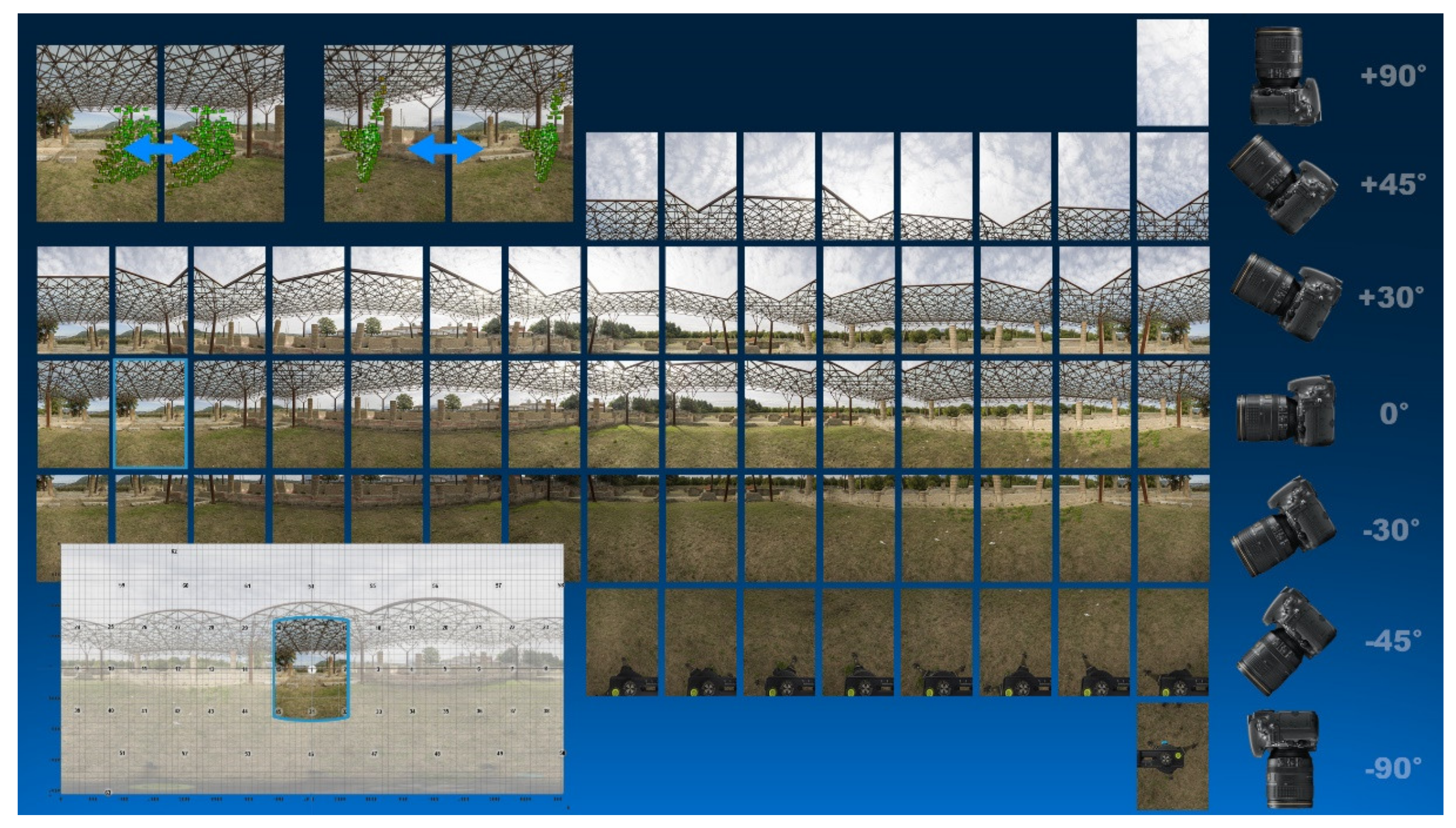
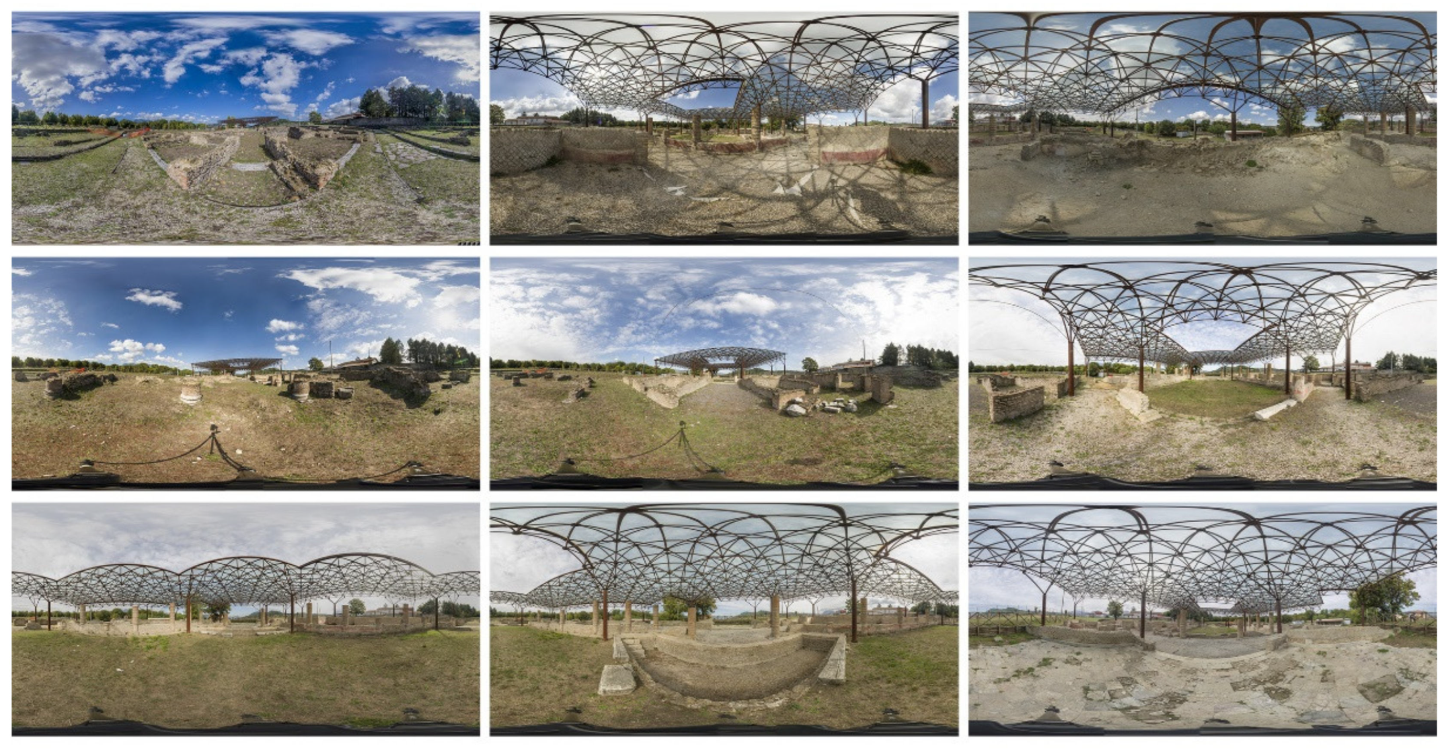
For the archaeological area of Abellinum, the immersive VR model is photo-based, and then each scenario requires a sequence of shots acquired with a camera that, rotating around its nodal point, covers the entire horizon circle (of 360°) for multiple inclinations (Figure 2). Subsequently, these shots are recomposed in the software environment on a spherical surface whose flat development generates a rectangle with a 2:1 ratio between the width and height of the image, constituting the plane of the projection [34], in a representation that is neither conforming nor equivalent (Figure 3). The geometric transformations for the transition from the spherical surface to a plane are attributable to the cylindrical equidistant cartographic projection, also called equirectangular, thanks to which it is possible to “flatten” on the drawing sheet the surface of the sphere (on which was projected the space surrounding the observer) with consequent changes in the properties of the representation in terms of distances, areas, or angles, as well as local variations of scale [35]. The space of representation is thus reduced from spherical to plane. Therefore, these images appear in plane, as is well known, in crawls shape with a series of deformations, some of them quite pronounced, that do not allow, at first glance, to recognise their spatial peculiarities; thanks to the use of visualisation supports, these deformations can be easily corrected, allowing the three-dimensionality of the space they represent to be understood [36].

Figure 2.
Single captures with different camera angles for the “mosaicisation” of the equirectangular panorama, showing (top) the control points for stitching between contiguous shots and (bottom) the “mosaicised” panorama with identification of the starting frame.

Figure 3.
Some of the panoramic images of the domus area of the archaeological area of Abellinum, in equirectangular projection.
4. Materials and Methods
The traditional tools needed for the production of immersive photographs are essentially a camera with its lens, tending to be wide-angle; a pan-head; and a solid tripod. Today, it is also possible to take 360° photographs with cameras designed specifically for this purpose and which allow you to shoot at speed or with your smartphone. With the latter equipment, however, the resolution of the output is usually lower. The evaluation of the specification of the instrumentation therefore depends not only on the circumstances of the shooting condition, but also on the choice of the quality of the acquisition, especially related to the camera and the lens.
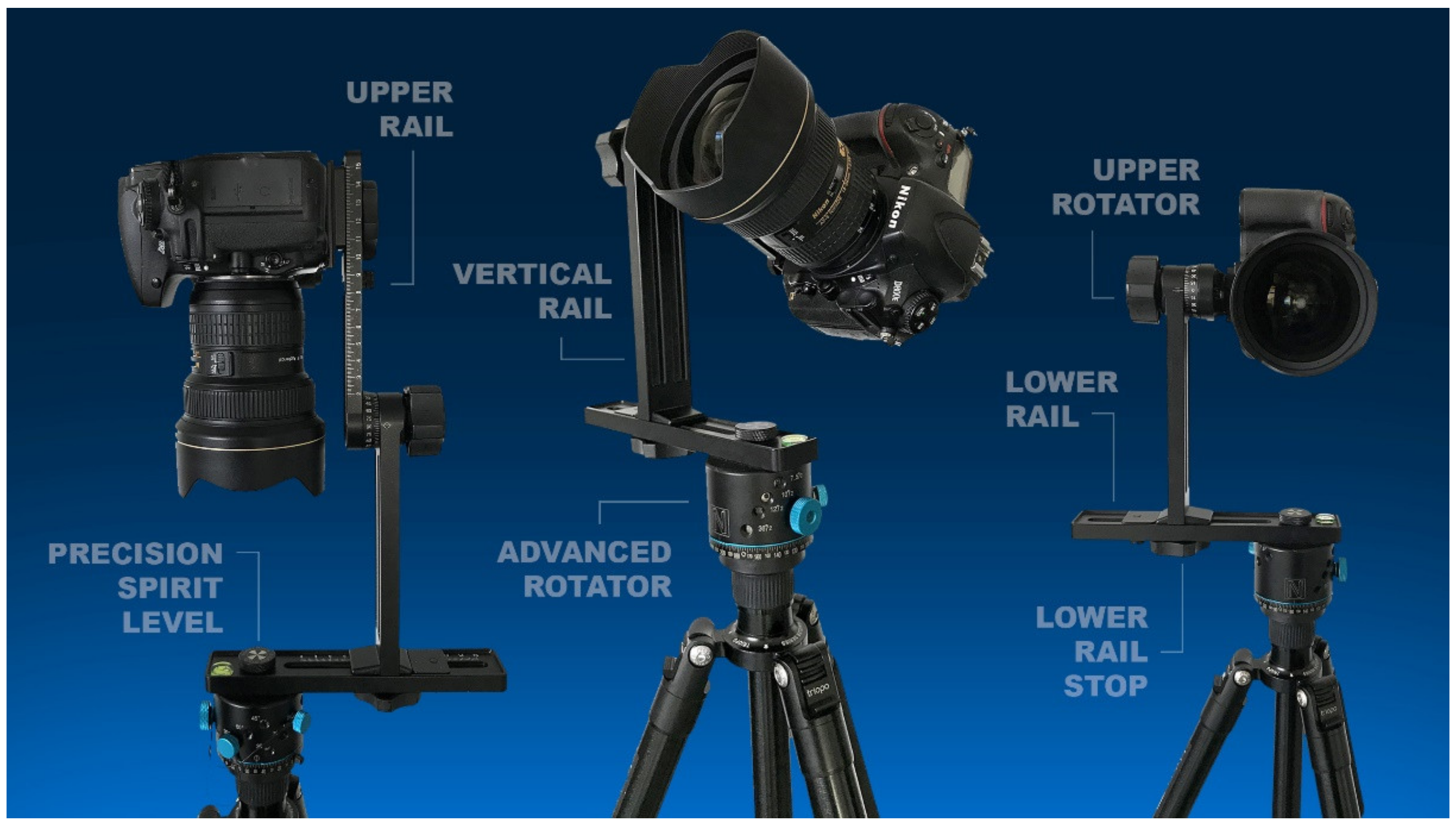
The camera used in this application was a Nikon single-lens reflex digital camera, model D800E, equipped with a 36.3 Megapixel FX (full-frame) CMOS sensor: single images of 7360 × 4912 pixels can be taken. The lens to which the camera is coupled consists of an AF-S NIKKOR 14–24 mm f/2.8 G ED wide-angle zoom lens, used here at a focal length of 24 mm. By positioning the camera in portrait orientation, with the values described, a horizontal field angle of about 53° and a vertical field angle of about 74° can be achieved. As it was therefore necessary to ensure for stitching an overlap of at least 50% between consecutive images, 15 shots per horizon turn were required to cover 360° (i.e., one every 24°); this operation was then repeated by tilting the camera by +30° and −30° for a total of 45 photos. Finally, for the nadiral and zenithal zones, the camera was tilted first by +45° and −45°, taking 8 photos per turn (i.e., one shot every 45°), and then tilted by +90° and −90°, adding another photo for each of the latter tilts, for a total of 63 photos for each station. The controlled rotational movement of the camera was provided by a pan-head placed on the tripod. In this particular case, a Nodal Ninja was used, a spherical, compact, manually operated pan-head (Figure 4). In particular, it consists of two micrometric slides that move in the two axes of the horizontal plane, resting on a cylinder that allows the horizontal rotation of the camera with pre-set steps to be chosen according to the chosen angle of field, which in turn depends on the focal length used.

Figure 4.
Photo capture set configurations with Nikon D800E combined with a 14–24 mm NIKKOR lens and Nodal Ninja panoramic head.
The vertical rotation of the camera, on the other hand, is ensured by a knob outside the mount that allows the tilt to be controlled by means of a graduated scale.
To ensure the accuracy of the shooting procedure, it is essential to correct the so-called “parallax error” before proceeding. Specifically, this is achieved by ensuring that the camera rotates around the nodal point, the optical centre of the lens. This is the point at which the incoming cone of light converges, reversing and thus impacting on the sensor to form the image. The correct position of the camera is therefore linked to the identification of this point, which is done only after having fixed the camera to the vertical arm, taking care that the plane of the sensor also remains vertical, and after having levelling the system. This centre of rotation is to be identified for each panoramic head combined with each camera-lens pair experimentally, adjusting the system with respect to the two horizontal slides (the one at the base and the one at the top).
Then, first, the camera is positioned with the optics pointing vertically downwards, and the lower slide is moved so that the centre of the optics is on an axis with the centre of the pan head, i.e., the vertical axis of the tripod. This position is indicated appropriately by a target that can be centred with the camera viewfinder to check for correct alignment.
At this point, the camera needs to be returned with the optics pointing towards the horizon and its position in relation to the upper horizontal slide assessed: the question is how far forward or how far back do you need to position it to ensure that rotation takes place around the nodal point?
To figure this out, here, we proceeded by trial and error: we took two vertical references on the scene, one in the proximity of the camera, the other in the background, composing the frame in such a way that the two references are perfectly aligned. Then, using the pivot cylinder at the base of the pan head, we rotated the camera by any angle and checked that despite the rotation, the two references remained in the same reciprocal position, i.e., they were still perfectly aligned. If this was not the case, it was necessary to move the camera forwards or backwards until the optimum setting was reached: until the parallax error was minimised, the nodal centre identified, and the rotation of the optical system around it ensured.
Having ascertained all the geometric variables, it was then time to set the camera so that the scene had two basic requirements: a balanced level of brightness and sufficient depth of field. Thanks to the open and sunny spaces of the archaeological area, achieving the first prerequisite was not difficult, but clearly it had to be balanced with the calculation of the depth of field. In fact, having the need to get everything sharp both for immersive realism and for correctness of the subsequent stitching operations, it was appropriate to work in hyperfocal, that is, to calculate the minimum distance at which to focus in order to have everything sharp from a certain value near the camera to infinity.
This one was of course associated with the focal length chosen, the aperture and the focusing distance: in our case, with a focal length of 24 mm, working at an aperture of f/14 and focusing at a distance of about 1.5 m, we guaranteed a sharp field from about 0.8 m from the camera to infinity. Then, after the camera calibration, 21 station points homogeneously arranged in the domus area were chosen, the sequence and placement of which was evaluated mainly on the idea of recreating a fluid user path.
Preliminary operations took about 15 min, while each station took an average of 5 min, for a net total of 2 h of work.
The images, organised by location and processed with general corrections in the Camera Raw environment, were exported in .jpg format and transferred to Autopano Giga stitching software. This software, as many other stitching software available on the market, can automatically produce control points from groups of photographs working on the areas of overlap. First, it performs a preliminary recognition calculation, reconstructing the orientation of the pictures in space, i.e., computing the horizontal angle (yaw), the vertical angle (pitch), and the angle about the main axis (roll). Then, the images were remapped onto a surface, which could be a plane, a cylinder, or a sphere, for obtaining the panorama projection desired.
The user can control and refine the stitching before starting the rendering operations to generate the final panorama. In fact, in addition to a rigorous capture methodology, the effects of optical aberrations for conventional cameras also need to be evaluated for achieving a perfect joint of the images that compose a panorama. In order to correct optical distortions before stitching, Adobe Lens Correction filter was performed on the raw images—the software accesses the Exif data of the images and matches it with presets from the Adobe database of cameras and lenses. The pre-treatment and the stitching phase took about 40 min for each panorama output.
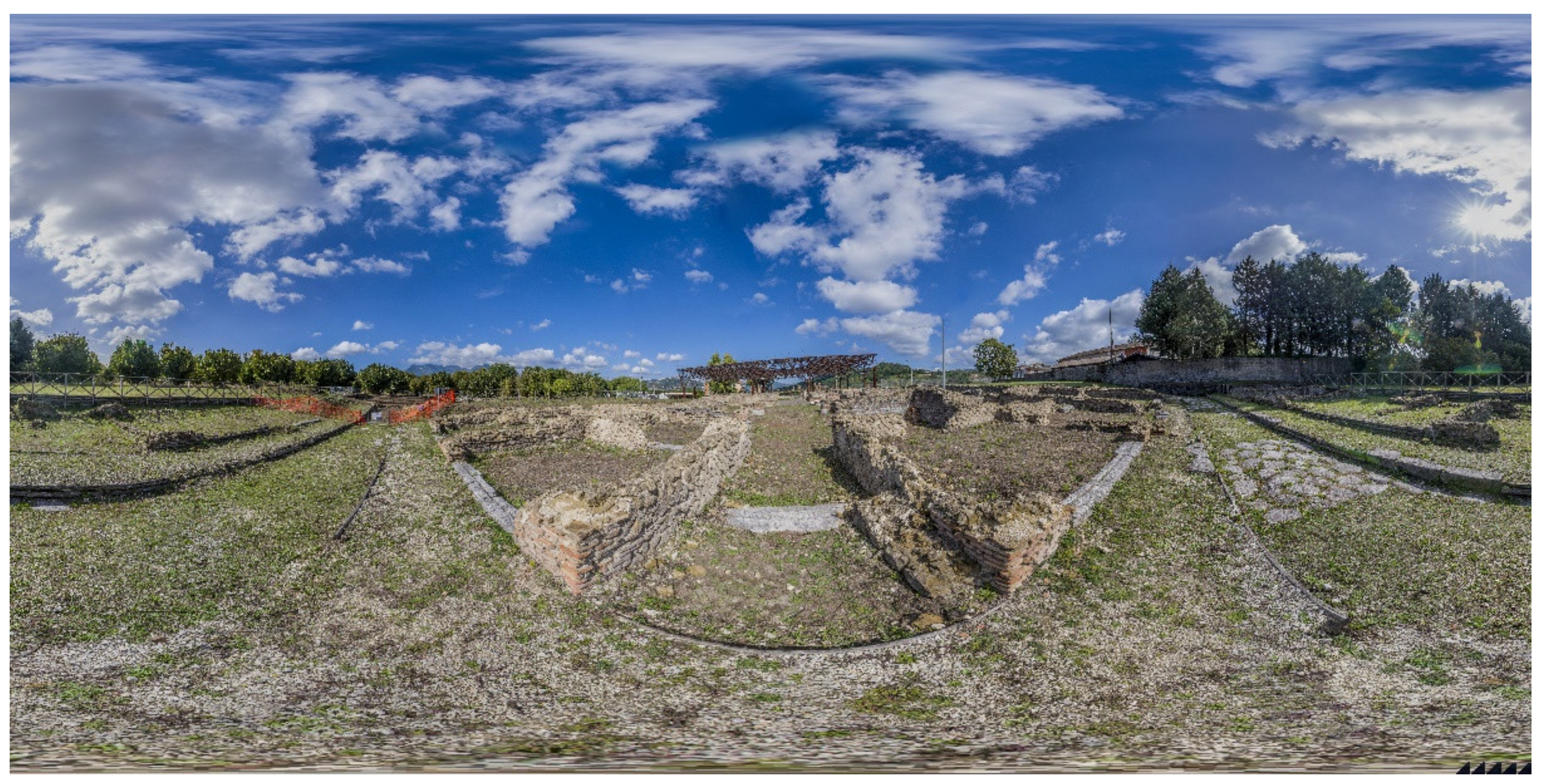
The final image, measuring 30,000 × 20,000 pixels, appears as a long photographic swipe of strong graphic impact (Figure 5), but still does not provide the sense of the three-dimensionality that is to be achieved. The last stage is then the transformation of the two-dimensional image into an immersive virtual view.

Figure 5.
A final panorama of one of the observation points in equirectangular projection (in-plane view).
The sense of three-dimensionality is rendered through common visualisation programs, some of which are open source, such as Quicktime or FSPViewer, which allow “full screen” viewing and a fully automatic rotational movement actually giving the feeling of truly looking out into the photographed scene. The sense of immersion is restored, however, through special viewers that allow stereoscopic viewing. However, the real transition from the photographic survey to the virtual visit takes place thanks to the opportunity to immediately link newly generated panoramas together, forming the so-called virtual tour (VT).
The VT is thus a new interactive graphic product that offers users the possibility of moving around in an immersive overview (and between several overviews), focusing their interest on freely chosen viewpoints. The addition of multimedia elements to the photographic environment, such as restoration simulations, texts, audio, or images, enriches the tool, configuring it as an information container.
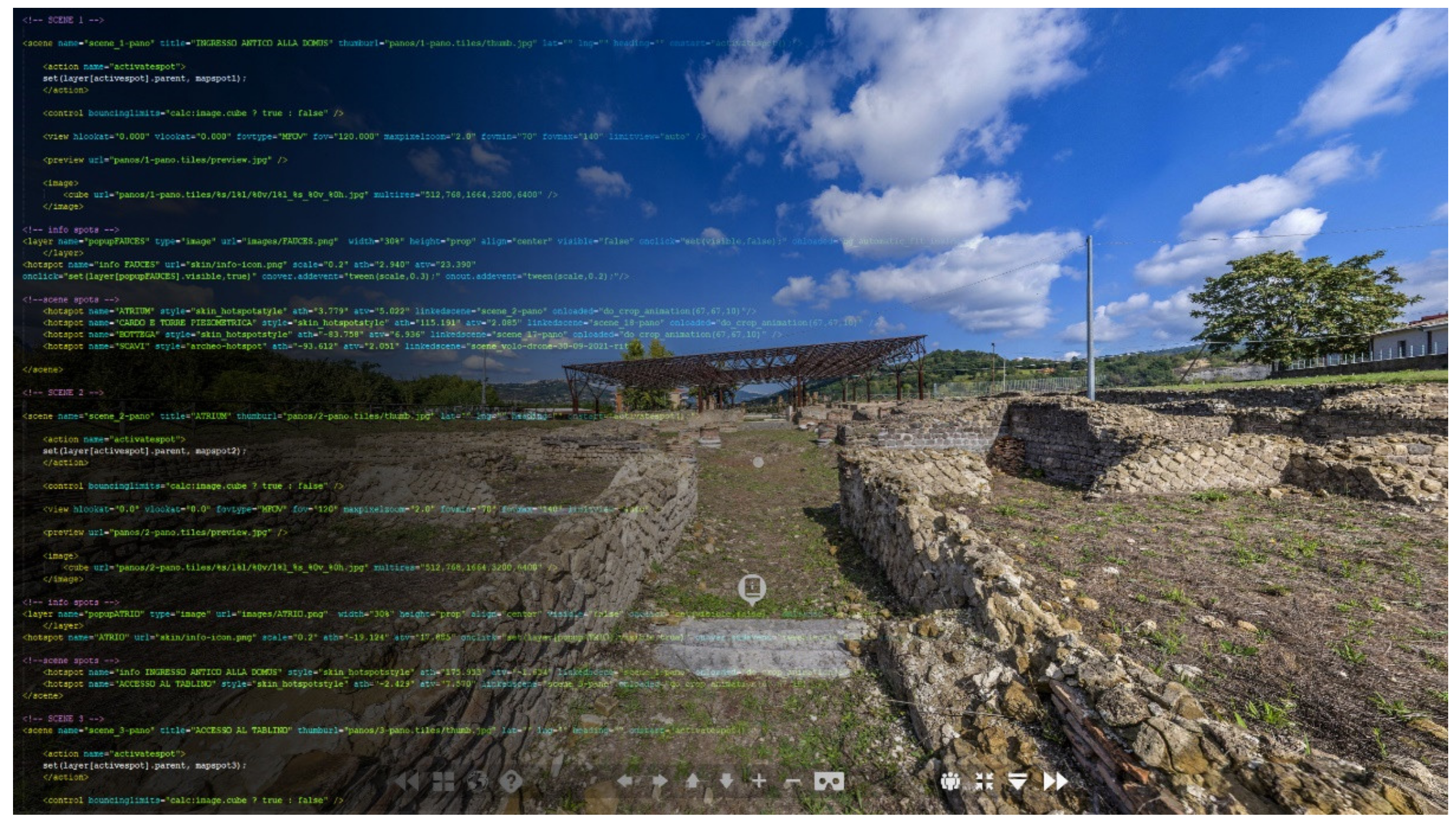
In this application, the VT space was generated through the use of krpano software, a high-performance tool, to show the panoramic images in a customisable web app environment. It uses simple .xml text files to store settings: this type of extension can be compiled or edited with any text editor, making it easier to understand and use even by inexperienced users. The interface is typical of programming; in fact, it is possible to build the front-end through the script for strings and call predefined commands from the software depending on the action to be achieved (Figure 6). By updating the .xml file from time to time, a local viewer allows one to view the progress of the project before it is uploaded online, depending on one’s needs and the information one wants to include in the VT. Data usability is, finally, made possible through hosting, ensuring immediate accessibility to the user by sharing a hyperlink.
5. Results
The quality and resolution of the 360° images obtained, as well as the spatial organisation of the stations, made it possible to develop a basis in a few hours for immersive virtualisation of the archaeological area.
The development of the VT was marked by the idea of the “empty container” in which high-resolution panoramas provide the setting for housing information content. At the same time, the experience-oriented approach led to the creation of a user-friendly product. This is why an interface was designed with a pop-up bottom context menu, including intuitive navigation controls, the ability to switch between panoramas by previewing them, access to a floor plan with radar for orientation from above, a navigation aid icon with instructions, and an immersive switcher for VR glasses.

Figure 6.
HTLM structure and starting scene of the virtual tour, including (bottom) a pop-up menu with information and orientation functions.
Figure 6.
HTLM structure and starting scene of the virtual tour, including (bottom) a pop-up menu with information and orientation functions.
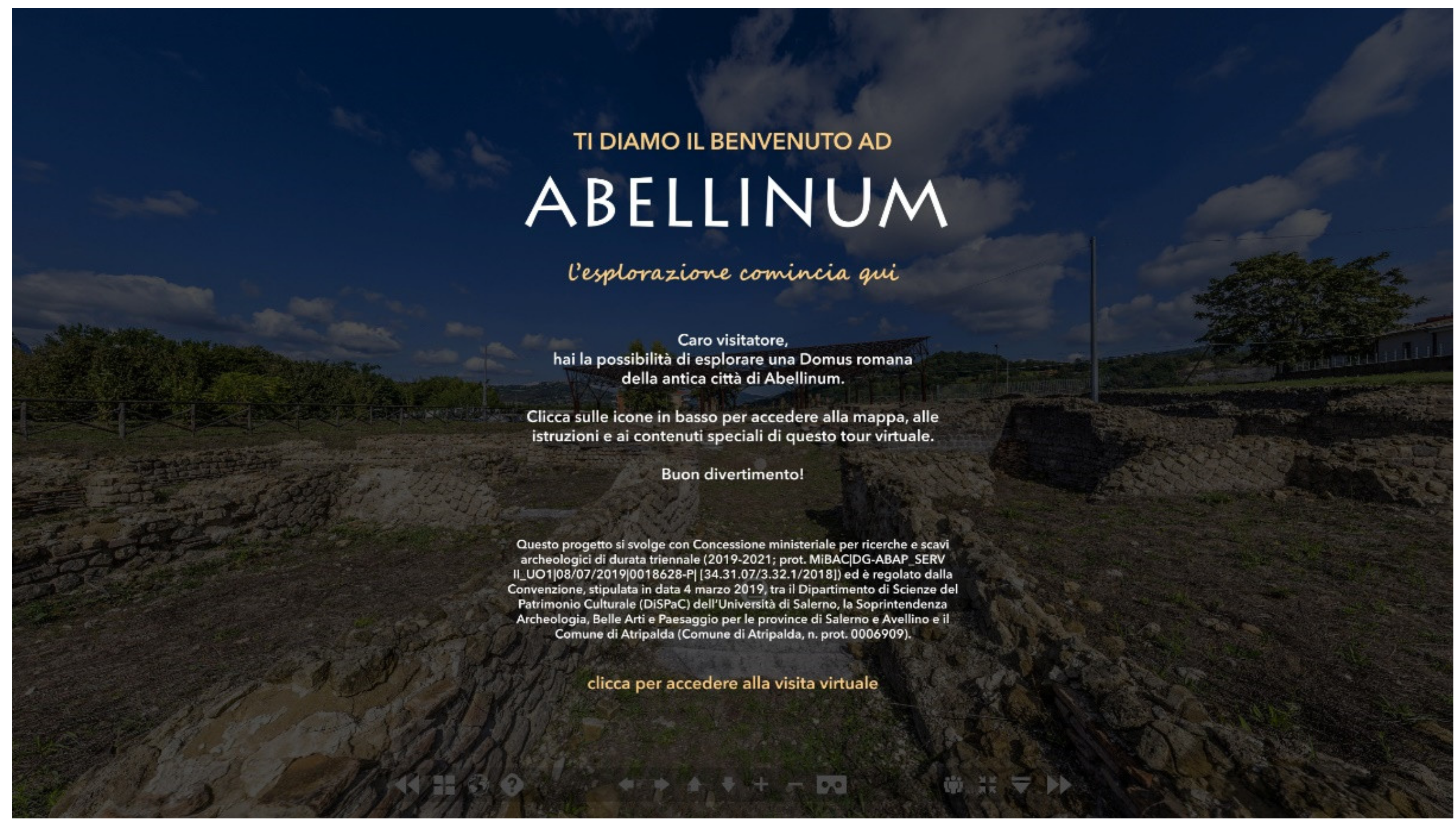
An introductory screen was found to be necessary in order not to directly project the user into the first scene (Figure 7). This screen has transparency, allowing a view of the tour below, and is a kind of welcome screen with the purpose of briefly introducing the tour. On the first click, the welcome screen turns off and the display switches to full screen, effectively beginning the virtual experience.

Figure 7.
Splash screen of the virtual tour, i.e., a customised introductory page, also aimed at hiding the loading process.
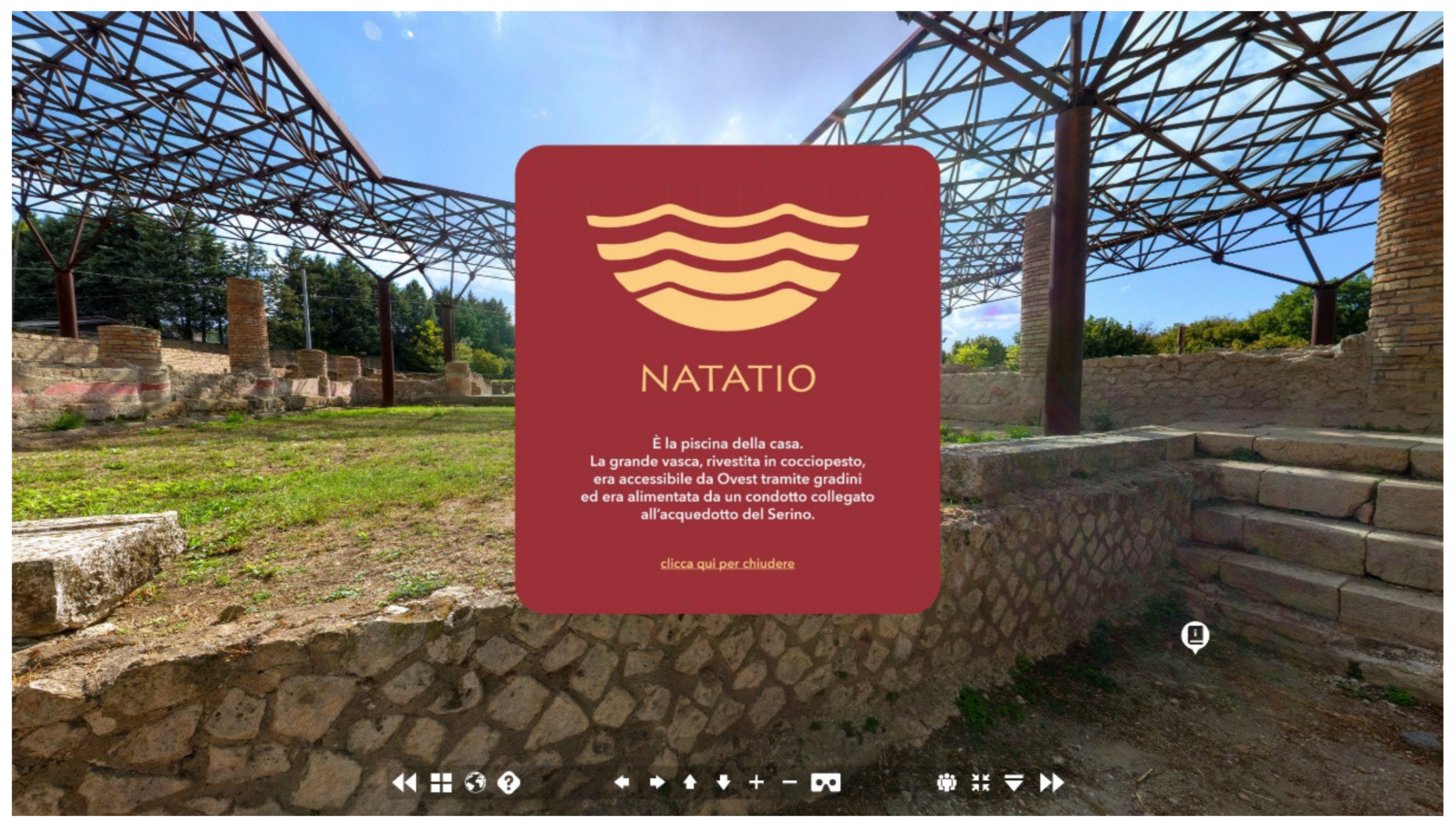
Each individual main station was given a pop-up description related to the space it covers and has bidirectional links (providing a return between scenes) to spatially adjacent scenes (Figure 8).

Figure 8.
Dynamic textual information on the elements of the displayed scene, activated by clicking on the information hotspot.
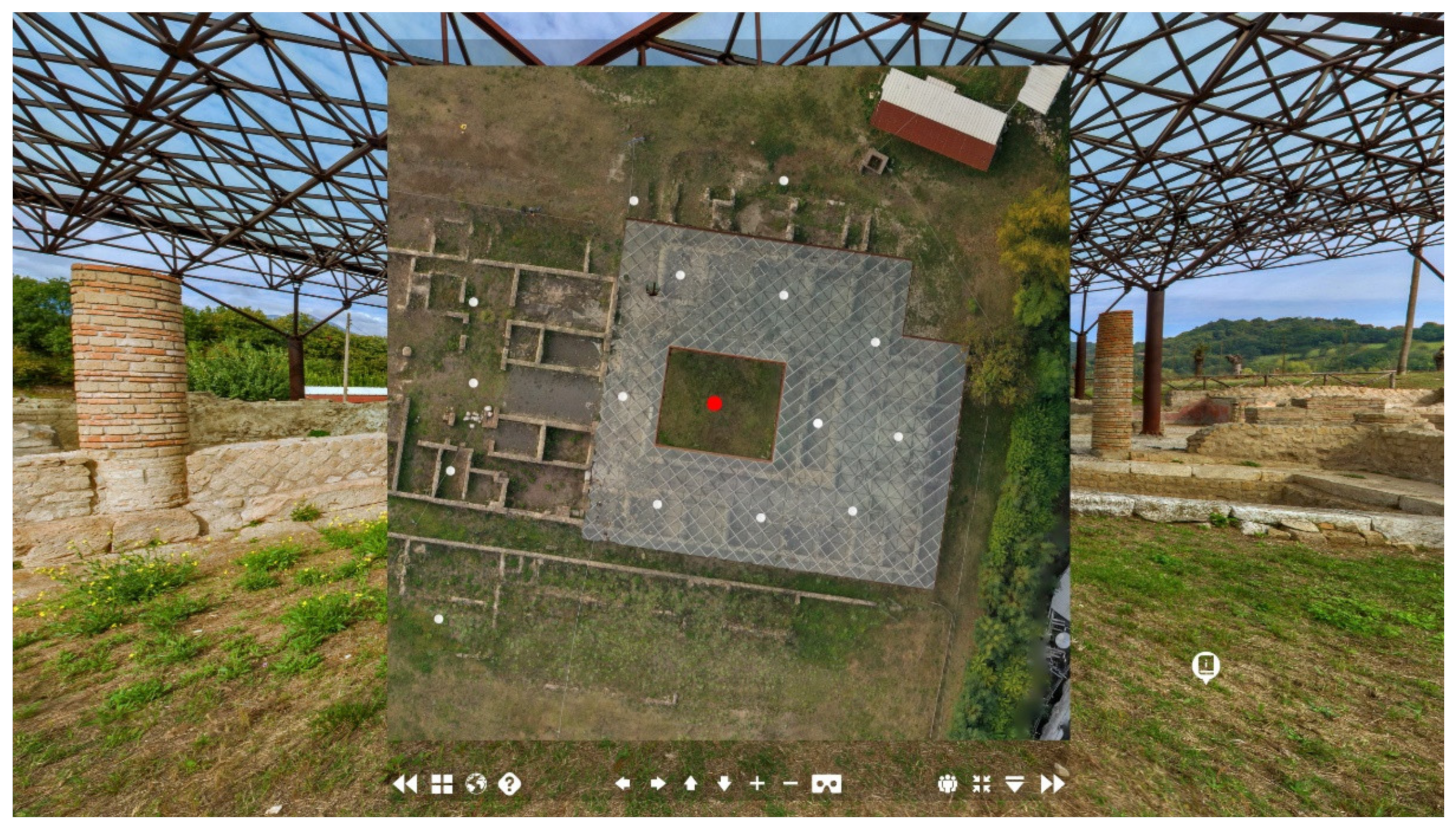
The following access modes are then provided to navigate among the sections: (i) by clicking on a point of interest within the floor plan (Figure 9); (ii) by clicking on pulsing hotspots within a panorama, which is associated with the name of the section that will be opened; (iii) by selecting the scene from the pop-up context menu at the bottom.

Figure 9.
Interactive virtual tour map with geo-location of the different observation points with direct access to them.
The appearance of the VT in terms of image quality allows for the readability and distinguishability of the details of the wall textures, the remains of the frescoes, and the materials of the domus, all of which are clearly visible and zoomable in detail to be enriched with technical information. In this way, it can facilitate the access to scientific data analysis and archaeological interpretations.
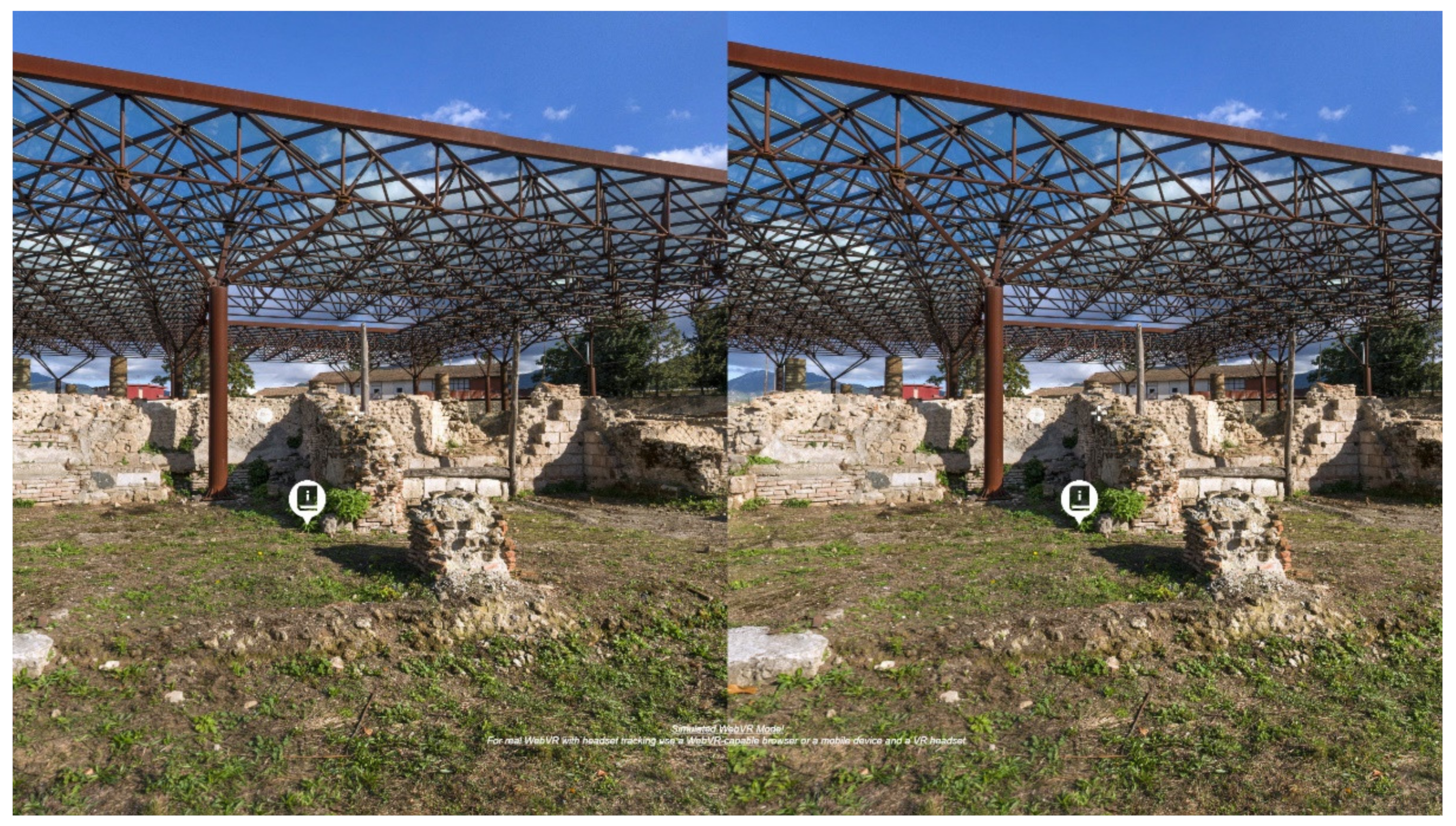
In addition, thanks to the use of low-cost stereoscopics terminals, such as Google Cardboard viewers, it is possible to make the experience immersive with just a few gestures: you insert your smartphone inside the viewer, select the stereoscopic option, turn off the screen lock, and wear the device, experiencing the feeling of being in the archaeological area (Figure 10).

Figure 10.
Stereo vision simulation for immersive visualisation using VR glasses.
The VT is currently available and navigable online (see the section: Supplementary Materials).
6. Discussion
The information base created by VT constitutes a shared digital digitisation system that can be implemented and expanded to catalogue, manage, study, and also enjoy the heritage of the Abellinum Archaeological Park. The purposes of VT, in perspective, therefore go beyond the virtual visit of a cultural site, such as a museum, an area, or an archaeological park: in line with strategies of governance, valorisation, and enjoyment of heritage, the use of this application is configured as a tool that responds to the needs of social, intellectual, and economic sustainability6 [37].
In this sense, the VT experience can provide a new impetus to those sites that, far from the tourist circuits and major attractors (i.e., Paestum, Pompeii), are neglected by investments and funding; are marginalised by innovative processes; and, as a result, too often suffer from inadequate forms of promotion [38,39,40].
In this context, one of the aspects that has emerged is the need to create a synergy between the different profiles gravitating around the field of CH, in detail for a first approach, engineers and archaeologists. The former take care of the methodological and technological aspects related to the data acquisition and management, proposing solutions adapted to the environmental and contextual conditions that may occur. This in relation to the detailed analysis of the context from an historical and archaeological point of view produced by the latter, which offer scientifically reliable content while using simple (non-trivialising) and inclusive language. The choice of language and, above all, communication approaches raised another issue, i.e., the theme of public and community archaeology [41,42] and social innovation strategies [43]: in fact, in order to set up strategies that foster participation and inclusiveness, the identification of the “public” proves crucial. This factor, also in the realisation of a VT, entails the study of the nature and type of audience by defining what all the possible stakeholders could be. Thus, it was found that many of these are involved in the governance and valorisation of CH (municipalities, superintendencies, etc.); furthermore, interest was aroused in those who enjoy it in a participative way (associations, schools, citizens, visitors, and tourists). The final product, in fact, might be suitable for large-scale recipients, being relied upon as a form of knowledge and communication, showing the various aspects of the study area in an easy to-understand form for users with no specialist qualifications and facilitating fruition and study work.
Nevertheless, it is well known that no single project can meet the needs of all communities and audiences, which is why there are common several limits to be taken into account. The generation gap is emblematic, with many older people having limited knowledge of new technologies or not being accustomed to using them. On the other hand, however, it is only the use of new technologies that attracts the interest of the new generations [44], who are excited to have a new experience within reach of their smartphones.
Another question related to the type of visitor concerns information material of a technical nature, which in this case can only be filtered for specialised users for the purpose of studying and sharing research results. In this case, it would be acceptable to create a customised multi-user interface, selectable at the beginning of the virtual visit.
Additionally, another issue is the availability of devices and means to access the service. In fact, it seems ironic that the opportunity for openness and sharing, for which access to the Internet can represent, is nevertheless restricted [45]—even today, large areas of the world do not have the necessary bandwidth to ensure fluid loading and running of websites and multimedia content, nor even access to the Internet, nor, at worst, electricity [46]. Then, although the use of this technology entails obvious limitations in this sense, it can on the one hand attract new user groups and on the other hand be made available offline where necessary. This is also in consideration of the relatively low cost of the methodology and the rapidity of the operations carried out to generate a first virtual experience, since there is no three-dimensional modelling of the spaces but a perceptive reconstruction of three-dimensionality, performed from two-dimensional photographs.
In addition, it is precisely the realism of the photographic data that leads to the question of another type of accessibility, that of mobility or geographical restrictions. The rigorous workflow, aided by the high resolution of the output, ensured the creation of photorealistic immersive environments. In this way, the VT can provide the user an experience that simulates a physical visit, succeeding in making participants the feeling of virtually visiting the archaeological site and creating a strong sense of presence due to the very powerful emotional impact [47].
Another focus concerns the information function, since VT constitutes the container of a basic content level, which can be updated and implemented any time. In this regard, the difficulties in incorporating data from different fields of knowledge becomes evident not only in choosing coherent ways of integration but also in presenting them effectively. In this sense, it will be the implementation of the tour with data on previously found artifacts and new excavations in progress, as well as the integration with reconstructive hypotheses and other data from survey campaigns, that could make the application appealing and will constitute its added value. Consequently, the next step that is intended to be taken in the immediate future is the enrichment of the VT with tools related to the management of the archaeological data (bibliographic sources, data analysis, administration, oral sources, graphic documents) in a global visual environment, starting from a geolocated object gallery of the findings, with an information windows as well as the possibility to view the finding in 3D, highlighting the role of the VT also as a didactic tool at different education levels [48].
7. Conclusions
This study presents the methodological process of realising high-resolution 360° photographs that linked together in the form of a virtual tour, thanks to the current developments in the management and implementation of digital data, can constitute a valid alternative—among the many on the market today [49]—for a first digitisation of heritage space and its information sharing. The aim was to focus on the methods and tools used, highlighting how the methodology described is applicable to most situations requiring accurate digital restitution [50], with particular attention paid to minor archaeological areas. Therefore, with a view to drawing public attention to one of these sites, an operational pipeline was proposed, with low time and financial outlay, for the dissemination of knowledge of an archaeological area that is still poorly explored, studied, and currently in a difficult state of accessibility and safety. Indeed, in Italy, where extraordinary archaeological heritage is concentrated, it is common to observe that the most well-known archaeological sites attract huge flows of tourists and investment, whereas many smaller archaeological sites remain almost ignored and neglected [51].
It is noticeable that the time is not yet ripe for the frontiers offered by recent digital infrastructures, in terms of documentation, representation, and dissemination, to be able to fully cover the needs related to the demand for digital models of heritage assets [52].
For this reason, rather than aiming at new tools, one should not underestimate the contribution that more “traditional” tools, such as photography, can still offer when renewed in application and above all chosen according to the purpose of the digitisation process. In this sense, a new declination of photography, aided by VR technology, can be recognised. Specifically, photographic-based virtual tour applications have in recent years proven an effectiveness in both representation and dissemination in various fields, including CH. The barriers it succeeds in breaking down are not only physical but also communicative, minimising the consumer side of the good and bringing out its spectacular side in the sense of uniqueness, performance, artwork, and experience. In addition, the visualisation possibilities offered by an interactive map, by moving around the places, implicitly lead the user to a broader and more participatory understanding, anticipating the planning of the physical visit.
On the basis of the sharing and prevailing efforts in this work, we believe that a transfer of cultural resources toward a sense of community ownership of the area is possible, helping to bring the public closer to the archaeological area and defining an innovative cultural offer.
Supplementary Materials
The following supporting material can be visited at https://Abellinumtour.centroictbc.unisa.it/ (accessed on 30 May 2022).
Author Contributions
All authors conceived and designed the experimental survey, methodology and conceptualisation; software, S.A.; formal analysis, S.A.; investigation, D.M.; data curation, A.d.F. All authors wrote the “Introduction” and the “Conclusions” paragraphs and reviewed and edited the entire paper. The “Case study” paragraph was written by D.M.; The recent rediscovery of immersive experiences and “Materials and Methods” paragraphs were written by S.A.; and the “Results” and “Discussion” paragraphs were written by A.d.F. All authors have read and agreed to the published version of the manuscript.
Funding
This research received no external funding.
Institutional Review Board Statement
Not applicable.
Informed Consent Statement
Not applicable.
Data Availability Statement
Not applicable.
Acknowledgments
We would like to thank Alfonso Santoriello, the project director, for combining the work of the civil engineers with that of the archaeologists once again and skilfully; engineer Marco Limongiello for the UAV acquisition campaign and the generation of the orthophotos for the interactive map; and “Centro ICT per i Beni Culturali” of the Università degli Studi di Salerno for the IT support in sharing the tour online.
Conflicts of Interest
The authors declare no conflict of interest.
Notes
| 1 | The term “digitisation” can be interpreted in its general sense of a “transformation of analogue signals into digital pieces”, as Maxwell and MacCain stated [16]. Nevertheless, this definition seems to be anachronistic today and, while still valid in its generality, it should be emphasised that digitalisation is the most significant on-going transformation of contemporary society, bringing added value to the whole economy and community [17]. |
| 2 | In this context, VT is a tool in the knowledge process. Indeed, it offers the possibility of storing and managing a large amount of information in different formats, allocated in a photographic immersive environment. It is therefore an implementable container in which information is verified and validated from a scientific point of view by technical specialists. |
| 3 | The project was born in mid-2019 from a collaboration between the Soprintendenza Archeologia; Belle Arti e Paesaggio per le province di Salerno e Avellino—MiBAC (MiBAC|DG-ABAP_SERV II_UO1|08/07/2019|0018628-P| [34.31.07/3.32.1/2018]); the Municipality of Atripalda (AV); and the Dipartimento di Scienze del Patrimonio Culturale (DiSPaC), Università degli Studi di Salerno, www.dispac.unisa.it/ricerca/focus?id=454 (accessed 30 May 2022). The project, directed by Prof. Alfonso Santoriello, assisted by Prof. Giacomo Pardini, and with the support of Prof. Aurora Egidio of DiSPaC, includes the participation of the Dipartimento di Ingegneria Civile (DICIV), Università degli Studi di Salerno for the surveys and representation of the area and the support of the Dipartimento di Farmacia (DIFARMA), Università degli Studi di Salerno for the analysis of the vegetal and environmental heritage. |
| 4 | A general review of the residential complex is underway: the focus is on an architectural analysis of the building and construction techniques, with the aim of detailing the construction sequence and organisation of spaces. The study, carried out by Dr. M. Covolan, is part of the recent investigations undertaken as part of the “Abellinum” project, which also includes archaeometric analyses on the decorated and frescoed surfaces for the mineralogical and petrographic characterisation of the raw materials (the research is carried out by Prof. C. Grifa, Dipartimento di Scienze e Tecnologia (DST), Università degli Studi del Sannio). |
| 5 | It refers to the Council of Europe’s Framework Convention on the Value of Cultural Heritage for Society, signed in Faro, Portugal, in 2005 and recently ratified by Italy, law 133 of 1 October 2020, https://www.coe.int/en/web/conventions/full-list?module=treaty-detail&treatynum=199 (accessed on 30 May 2022). |
| 6 | The strategies adopted aim at building a cultural ecosystem through the promotion and requalification of the historical, architectural, archaeological, environmental, and identifying heritage: if not adequately valued, it risks the disappearance or alteration of its founding values, entailing the loss of history, but also opportunities for sustainable tourism and economic development. |
References
- Lerario, A. The IoT as a Key in the Sensitive Balance between Development Needs and Sustainable Conservation of Cultural Resources in Italian Heritage Cities. Sustainability 2020, 12, 6952. [Google Scholar] [CrossRef]
- Younan, S.; Treadaway, C. Digital 3D models of heritage artefacts: Towards a digital dream space. Digit. Appl. Archaeol. Cult. Herit. 2015, 2, 240–247. [Google Scholar] [CrossRef]
- Gruen, A. Reality-Based Virtual Models in Cultural Heritage. In ‘Archaeologizing’ Heritage? Transcultural Research—Heidelberg Studies on Asia and Europe in a Global Context; Falser, M., Juneja, M., Eds.; Springer: Berlin/Heildeberg, Germany, 2013; pp. 109–126. [Google Scholar]
- Fassi, F.; Mandelli, A.; Teruggi, S.; Rechichi, F.; Fiorillo, F.; Achille, C. VR for Cultural Heritage. In Augmented Reality, Virtual Reality, and Computer Graphics; De Paolis, L., Mongelli, A., Eds.; Springer: Berlin/Heildeberg, Germany, 2016; pp. 139–157. [Google Scholar]
- Apollonio, F.I.; Basilissi, V.; Callieri, M.; Dellepiane, M.; Gaiani, M.; Ponchio, F.; Rizzo, F.; Rubino, A.R.; Scopigno, R.; Sobra’, G. A 3D-centered information system for the documentation of a complex restoration intervention. J. Cult. Herit. 2018, 29, 89–99. [Google Scholar] [CrossRef]
- Recupero, A.; Talamo, A.; Triberti, S.; Modesti, C. Bridging Museum Mission to Visitors’ Experience: Activity, Meanings, Interactions, Technology. Front. Psychol. 2019, 10, 2092. [Google Scholar] [CrossRef] [PubMed]
- Messina, B.; Chiarenza, S.; di Filippo, A. Digital for sustainable use of cultural heritage: The Baptistery of Nocera Superiore. In World Heritage and Design for Health, Le Vie dei Mercanti XIX International Forum; Gambardella, C., Ed.; Gangemi Editore: Rome, Italy, 2021. [Google Scholar]
- Letellier, R. Recording, Documentation, and Information Management for the Conservation of Heritage Places; The Getty Conservation Institute: Los Angeles, CA, USA, 2007; p. 11. [Google Scholar]
- Doğan, Y.; Yakar, M. GIS and three-dimensional modeling for cultural heritages. Int. J. Eng. Geosci. 2018, 3, 50–55. [Google Scholar] [CrossRef] [Green Version]
- Morena, S.; Barba, S.; Álvaro-Tordesillas, A. Shining 3D Einscan-Pro, application and validation in the field of Cultural Heritage, from the Chillida-Leku Museum to the Archaeological Museum of Sarno. ISPRS Int. Arch. Photogramm. Remote Sens. Spat. Inf. Sci. 2019, XLII-2/W18, 135–142. [Google Scholar] [CrossRef] [Green Version]
- Rossi, C.; Achille, C.; Fassi, F.; Lori, F.; Rechichi, F.; Fiorillo, F. Digital Workflow to Support Archaeological Excavation: From the 3D Survey to the Websharing of Data. In Innovative Models for Sustainable Development in Emerging African Countries. Research for Development; Aste, N., Della Torre, S., Talamo, C., Adhikari, R., Rossi, C., Eds.; Springer: Berlin/Heildeberg, Germany, 2019; pp. 149–157. [Google Scholar]
- Limongiello, M.; Gujski, L.M. Image—Based Modelling Restitution: Pipeline for Accuracy Optimisation. In Representation Challenges. Augmented Reality and Artificial Intelligence in Cultural Heritage and Innovative Design Domain; Giordano, A., Russo, M., Spallone, R., Eds.; FrancoAngeli: Milano, Italy, 2021; pp. 197–201. [Google Scholar]
- Napolitano, R.K.; Scherer, G.; Glisic, B. Virtual tours and informational modeling for conservation of cultural heritage sites. J. Cult. Herit. 2018, 29, 123–129. [Google Scholar] [CrossRef]
- Trillo, C.; Aburamadan, R.; Mubaideen, S.; Salameen, D.; Chikomborero Ncube Makore, B. Towards a Systematic Approach to Digital Technologies for Heritage Conservation. Insights from Jordan. Preserv. Digit. Technol. Cult. 2021, 49, 121–138. [Google Scholar] [CrossRef]
- Dell’Amico, A. Fast survey: Methods of smart representation for the monitoring and management of the churches hit by the earthquake in the province of Teramo. In UID 2019 Reflections. The Art of Drawing/The Drawing of Art; Belardi, P., Ed.; Gangemi Editore: Rome, Italy, 2019; pp. 1533–1542. [Google Scholar]
- Maxwell, L.; McCain, T. Gateway or gatekeeper: The implications of copyright and digitalization on education. Commun. Educ. 1997, 46, 141–157. [Google Scholar] [CrossRef]
- Reis, J.; Amorim, M.; Melão, N.; Cohen, Y.; Rodrigues, M. Digitalization: A Literature Review and Research Agenda. In The Next Generation of Production and Service Systems, Proceedings on 25th International Joint Conference on Industrial Engineering and Operations Management—IJCIEOM, Rio de Janeiro, Brazil, 8–11 July 2020; Lecture Notes on Multidisciplinary Industrial Engineering; Anisic, Z., Lalic, B., Gracanin, D., Eds.; Springer: Cham, Switzerland, 2020; pp. 443–456. [Google Scholar]
- Bakirman, T.; Gumusay, M.U. Integration of custom street view and low-cost motion sensors. Int. J. Eng. Geosci. 2020, 5, 66–72. [Google Scholar] [CrossRef]
- UNESCO Report, Museums Around the World in the Face of COVID-19. Available online: https://unesdoc.unesco.org/ark:/48223/pf0000376729_eng/PDF/376729eng.pdf.multi (accessed on 28 April 2022).
- Rossi, A. Rapid techniques for immersive experiences. Expected and achieved results: A comparison. In Immersive High Resolution Photographs for Cultural Heritage; Rossi, A., Ed.; Libreriauniversitaria.it: Padova, Italy, 2017; pp. 7–19. [Google Scholar]
- Santoriello, A. “Abellinum—Piano per la conoscenza, la tutela e la valorizzazione dell’antico centro irpino. Sviluppi e prospettive” incontro sul campo domani al Parco Archeologico. Atripalda News, 15 July 2021; pp. 211–214. [Google Scholar]
- Fariello, M. Atripalda. In Gli Eubei in Occidente, Proceedings of the XVIII Convegno di Studi sulla Magna Grecia, Taranto, Italy, 8–12 Ottobre 1978; Istituto per la Storia e l’Archeologia della Magna Grecia: Taranto, Italy, 1978; pp. 313–316. [Google Scholar]
- Colucci Pescatori, G. Evidenze archeologiche in Irpinia. In La Romanisation Du Samnium Aux IIe et Ier Siècles Av. J.-C., Proceedings of the Colloque International, Naples, Italy, 4–5 November 1988; Centre Jean Bérard: Naples, Italy, 1991; pp. 85–122. [Google Scholar]
- Colucci Pescatori, G. Per Una Storia Archeologica Dell’Irpinia: Dall’istituzione Del Museo Irpino Alle Ricerche Del Secolo Scorso. In Appellati Nomine Lupi—Giornata Internazionale di Studi sull’Hirpinia e gli Hirpini; Franciosi, V., Visconti, A., Avagliano, A., Saldutti, V., Eds.; Suor Orsola Benincasa University: Naples, Italy, 2017; pp. 131–206. [Google Scholar]
- Colucci Pescatori, G. Osservazioni su Abellinum tardo-antica e sull’eruzione del 472 d.C. In Tremblements de Terre, Éruptions Volcaniques et Vie des Hommes dans la Campania Antique; Centre Jean Bérard: Naples, Italy, 1986; pp. 121–141. [Google Scholar]
- Smith, L.; Waterton, E. Heritage, Communities and Archaeology; Bloomsbury: London, UK, 2009. [Google Scholar]
- Thomas, S. Community Archaeology. In Key Concepts in Public Archaeology; Moshenska, G., Ed.; UCL Press: London, UK, 2017; pp. 14–30. [Google Scholar]
- Antinozzi, S. Procedure di image editing di panorami a 360° per la visualizzazione tridimensionale di spazi architettonici. Folio 2020, 36, 36–45. [Google Scholar]
- Pascariello, M.I.; Fiorillo, F. Il progetto d’illusione dalle prospettive dipinte alla fotografia immersiva. In Immersive High Resolution Photographs for Cultural Heritage; Rossi, A., Ed.; Libreriauniversitaria.it: Padova, Italy, 2017; pp. 89–101. [Google Scholar]
- Rossi, D. Brand new: Panorama. L’immagine continua per il disegno della realtà virtuale. In UID 2018 Rappresentazione/Materiale/Immateriale. Drawing as (In)Tangible Representation; Salerno, R., Ed.; Gangemi Editore: Rome, Italy, 2019; pp. 1405–1412. [Google Scholar]
- Assintel Report 2020. Il Mercato ICT e L’evoluzione Digitale in Italia. IDC. Available online: https://d110erj175o600.cloudfront.net/wp-content/uploads/2019/10/assintel2020.pdf (accessed on 5 May 2022).
- Virtual Reality Market Size, Share & Trends Analysis Report by Technology (Semi & Fully Immersive, Non-Immersive), by Device (HMD, GTD, PDW), by Component (Hardware, Software), by Application, by Region, and Segment Forecasts, 2022–2030. Available online: https://www.grandviewresearch.com/industry-analysis/virtual-reality-vr-market (accessed on 5 May 2022).
- Olivero, L.F.; Rossi, A.; Barba, S. A codification of the cubic projection to generate immersive models. Diségno 2019, 4, 53–64. [Google Scholar]
- Bandeira Araújo, A. Drawing Equirectangular VR Panoramas with Ruler, Compass, and Protractor. J. Sci. Technol. Arts 2018, 10, 15–27. [Google Scholar] [CrossRef] [Green Version]
- Bandeira Araújo, A. Guidelines for drawing immersive panoramas in equirectangular perspective. In Interfaces of Tomorrow, Artech2017: 8th International Conference on Digital Arts, Macau, China, 6–8 September 2017; Caires, C., Ed.; ACM: New York, NY, USA, 2017; pp. 1–7. [Google Scholar]
- Leserri, M.; Morena, S.; Antinozzi, S. Lapis resiliency, through analogic and digital drawing. In EGA 2022: Architectural Graphics; Springer Series in Design and Innovation; Ródenas-López, M.A., Calvo-López, J., Salcedo-Galera, M., Eds.; Springer: Cham, Switzerland, 2022; Volume 23, pp. 126–136. [Google Scholar]
- Belford, P. Sustainability in Community Archaeology. Arqueol. Pùblica 2014, 4, 21–44. [Google Scholar] [CrossRef]
- Barca, F.; Casavola, P.; Lucatelli, S. Strategia nazionale per le aree interne: Definizione, obiettivi, strumenti e governance. In Materiali Uval 31; Barca, F., Casavola, P., Lucatelli, S., Eds.; Unità di valutazione degli investimenti pubblici: Rome, Italy, 2014. [Google Scholar]
- Ficorilli, S.; Murzi, M. Stati Generali del Paesaggio; Gangemi Editore: Rome, Italy, 2018. [Google Scholar]
- Santoriello, A. Paesaggi culturali: Conoscenza, sostenibilità, partecipazione. In Landscapes. Paesaggi Culturali; Cambi, F., Mastroianni, D., Nizzo, V., Pignataro, F., Sanchirico, S., Eds.; Fondazione Dià Cultura: Rome, Italy, 2021; pp. 193–205. [Google Scholar]
- Volpe, G. Archeologia Pubblica. Metodi, Tecniche, Esperienze; Carocci: Rome, Italy, 2020. [Google Scholar]
- Santoriello, A. Dalla Convenzione di Faro alle Comunità: Raccontare l’archeologia e le vocazioni storiche di un territorio. L’esperienza di Ancient Appia Landscapes. In Raccontare L’archeologia. Strategie e Tecniche per la Comunicazione dei Risultati delle Ricerche Archeologiche; Pallecchi, S., Ed.; All’Insegna del Giglio: Firenze, Italy, 2014; pp. 103–111. [Google Scholar]
- Gould, P. Empowering Communities through Archaeology and Heritage: The Role of Local Governance in Economic Development; Bloomsbury: London, UK, 2018. [Google Scholar]
- Szczepanska, A.; Kazmierczak, R.; Myszkowska, M. Virtual Reality as a Tool for Public Consultations in Spatial Planning and Management. Energies 2021, 14, 6046. [Google Scholar] [CrossRef]
- Dawson, P.C.; Porter, C.; Gadbois, D.; Keith, D.; Hughes, C.; Suluk, L. “Some Account of an Extraordinary Traveller”: Using Virtual Tours to Access Remote Heritage Sites of Inuit Cultural Knowledge. Études Inuit Stud. 2018, 42, 243–268. [Google Scholar] [CrossRef]
- Ritchie, H.; Roser, M.; Rosado, P. Energy. Our World in Data 2020. Available online: https://ourworldindata.org/energy-access (accessed on 22 June 2022).
- Kyrlitsias, C.; Christofi, M.; Michael-Grigoriou, D.; Banakou, D.; Ioannou, A. A Virtual Tour of a Hardly Accessible Archaeological Site: The Effect of Immersive Virtual Reality on User Experience, Learning and Attitude Change. Front. Comput. Sci. 2020, 2, 23. [Google Scholar] [CrossRef]
- Wrzesien, M.; Raya, M.A. Learning in serious virtual worlds: Evaluation of learning effectiveness and appeal to students in the E-Junior project. Comput. Educ. 2010, 55, 178–187. [Google Scholar] [CrossRef]
- Chiabrando, F.; Donato, V.; Lo Turco, M.; Santagati, C. Cultural Heritage Documentation, Analysis and Management Using Building Information Modelling: State of the Art and Perspectives. In Mechatronics for Cultural Heritage and Civil Engineering. Intelligent Systems, Control and Automation: Science and Engineering; Ottaviano, E., Pelliccio, A., Gattulli, V., Eds.; Springer: Cham, Switzerland, 2018. [Google Scholar]
- Cabezos-Bernal, P.M.; Cisneros-Vivó, J.J. Photogrammetric 2D/3D restitution of architectural elements and the integration of virtual models with his photographed real environment, using CAD, freeware software and conventional cameras. DisegnareCon 2013, 6, 1–11. [Google Scholar]
- Giuffrida, S.; Gagliano, F.; Giannitrapani, E.; Marisca, C.; Napoli, G.; Trovato, M.R. Promoting Research and Landscape Experience in the Management of the Archaeological Networks. A Project-Valuation Experiment in Italy. Sustainability 2020, 12, 4022. [Google Scholar] [CrossRef]
- Champion, E.; Rahaman, H. Survey of 3D digital heritage repositories and platforms. Virtual Archaeol. Rev. 2020, 11, 23. [Google Scholar] [CrossRef]
Publisher’s Note: MDPI stays neutral with regard to jurisdictional claims in published maps and institutional affiliations. |
© 2022 by the authors. Licensee MDPI, Basel, Switzerland. This article is an open access article distributed under the terms and conditions of the Creative Commons Attribution (CC BY) license (https://creativecommons.org/licenses/by/4.0/).

