
Kalymnos Island, SE Aegean Sea: From Fishing Sponges and Rock Climbing to Geotourism Perspective


Abstract
:1. Introduction
2. Materials and Methods
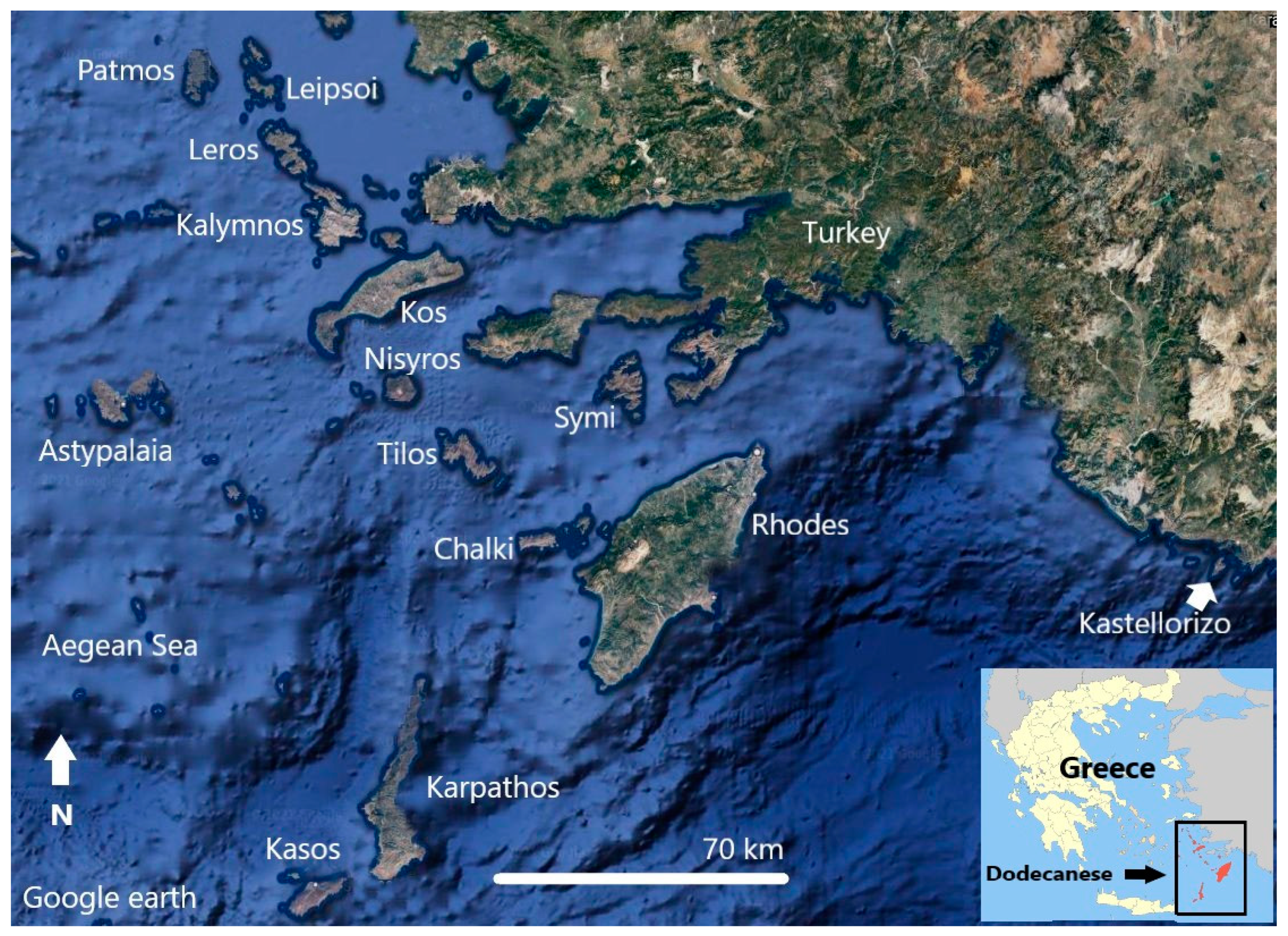
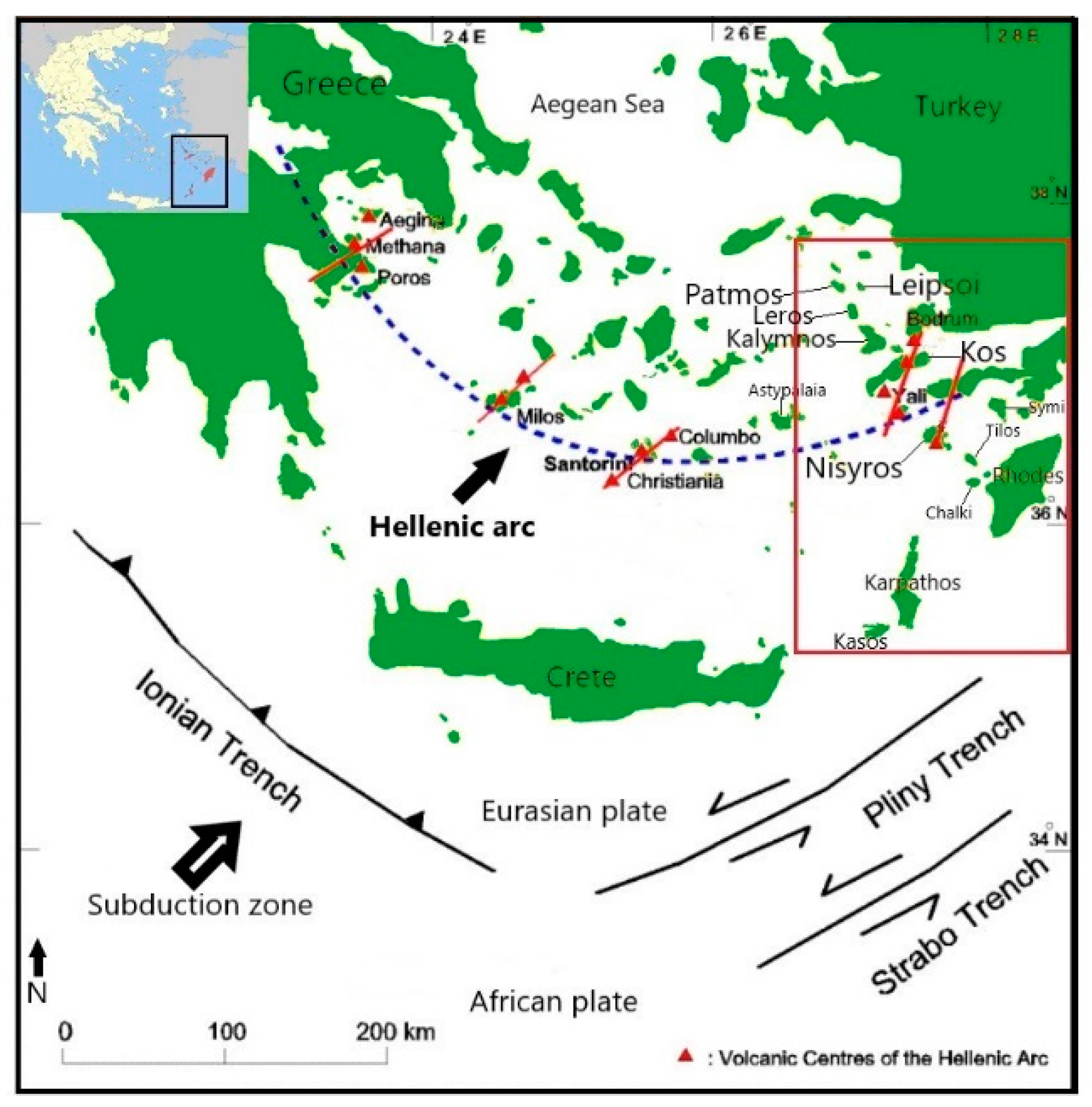
2.1. The Study Area
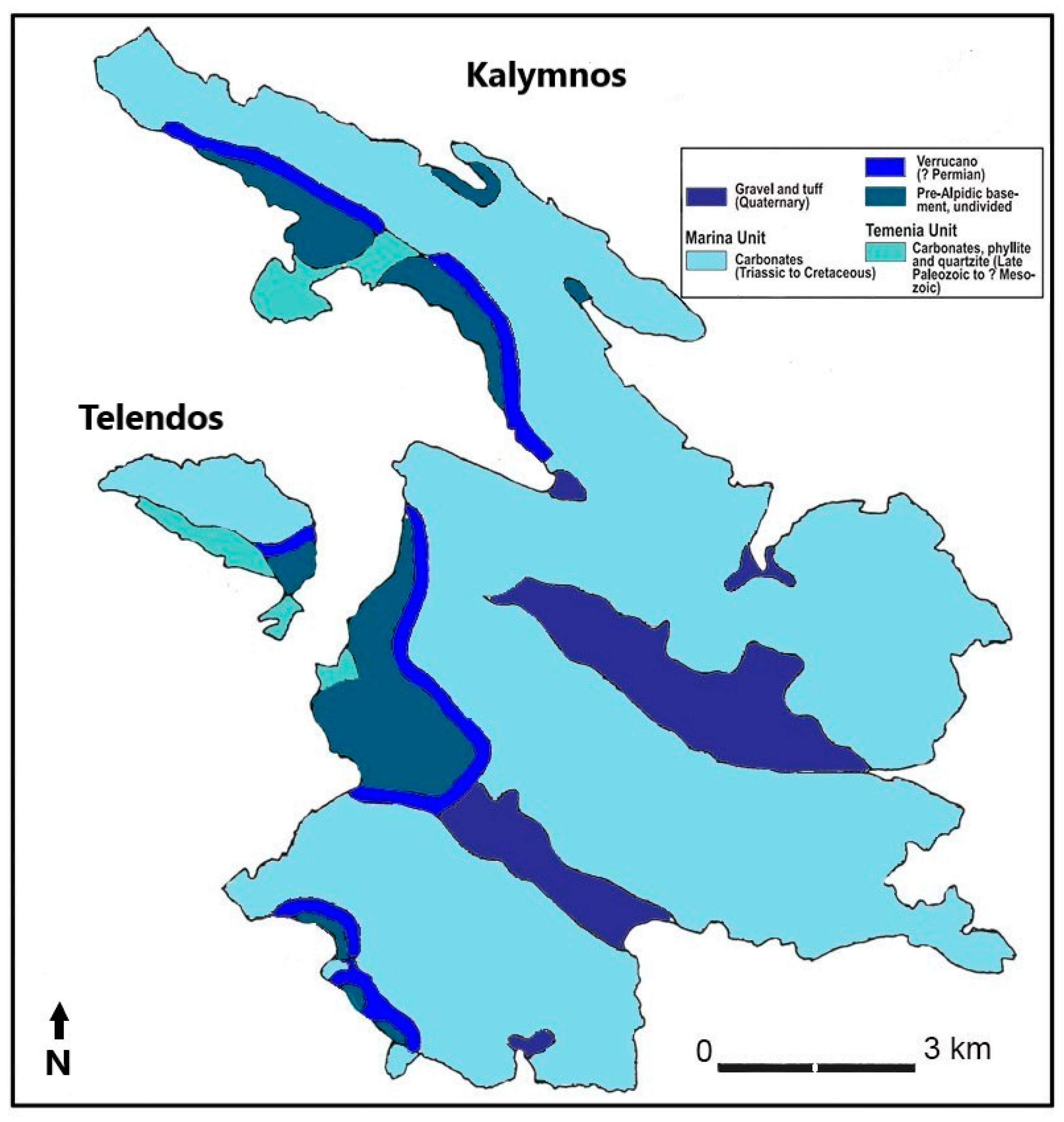
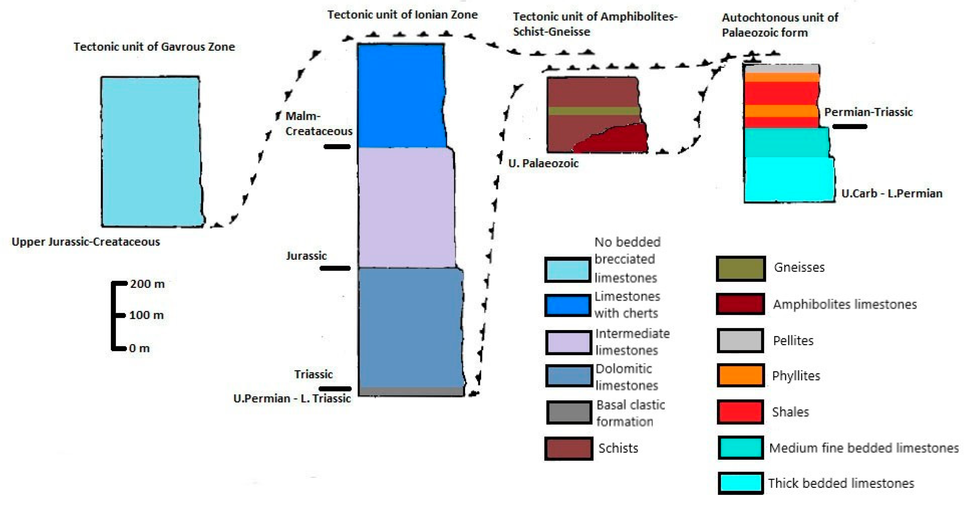
2.2. Geology-Geomorphology
- Paleozoic unit: it is the oldest unit, and its deepest members are mostly thick-bedded white and dolomite limestones. The intermediate parts are made up of dark thickly bedded and thinly bedded limestones, while the higher members are made up of shale, phyllite, and clay schists with layers of limestone intercalations.
- Tectonic unit of amphibolites, schists, and gneisses: amphibolites can be found in narrow alternations between schists and gneisses. They are fine-grained, middle-grained, and gross-grained rocks with an Upper Carboniferous age.
- Tectonic unit of the Ionian Zone: This unit is made up of sub-units, which are listed below:
- ○
- Clastic base formations of upper Permian: they form the base of the Ionian zone and are composed of fine-grained to coarse-grained sandstones, conglomerates, metashales, clay schists, and micritic and breccial limestones.
- ○
- Triassic dolomites and dolomite limestones. They generated a typical transition on the clastic base formation.
- ○
- Middle limestones are the typical upper development of Triassic dolomites and dolomite limestones. The bottom components are bituminous.
- ○
- Malmian-Cretaceous upper and middle cherty limestones.
- Tectonic unit of Gavrovos zone of upper Jurassic-Cretaceous age, represented by a limestone of considerable thickness.
- Neogene formations: they occur in a variety of locations throughout the island, covering just small areas. They are made up of white marls, yellow-red clays, clay-marls with a gray to gray-yellow tint, white marl limestones, brown-gray and gray thin-middle and thick layered conglomerates, and conglomerates with argillaceous-marly matrix. The Neogene formations are of limnic origin and may be Pliocene in age.
- Quaternary formations which contain the following formations:
- ○
- Pleistocene formations made up by consolidated slide rocks and fan conglomerate, volcanic tuffs, and a volcanic pyroclastic formation with rhyolite as the main component.
- ○
- Holocene formations which comprise talus slope screes and detrital cones, terra-rossa alluvial valley deposits, and coastal sands.
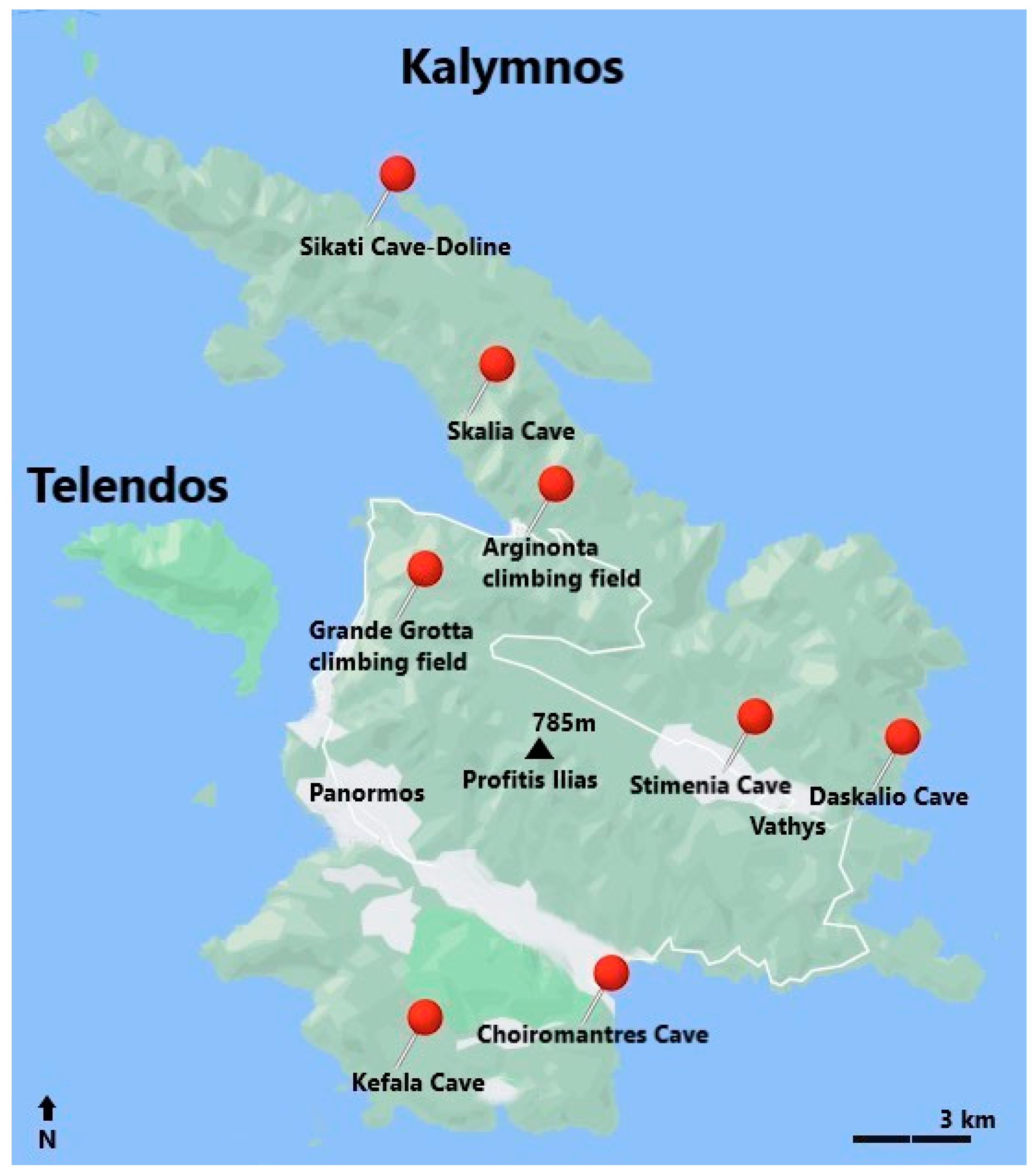
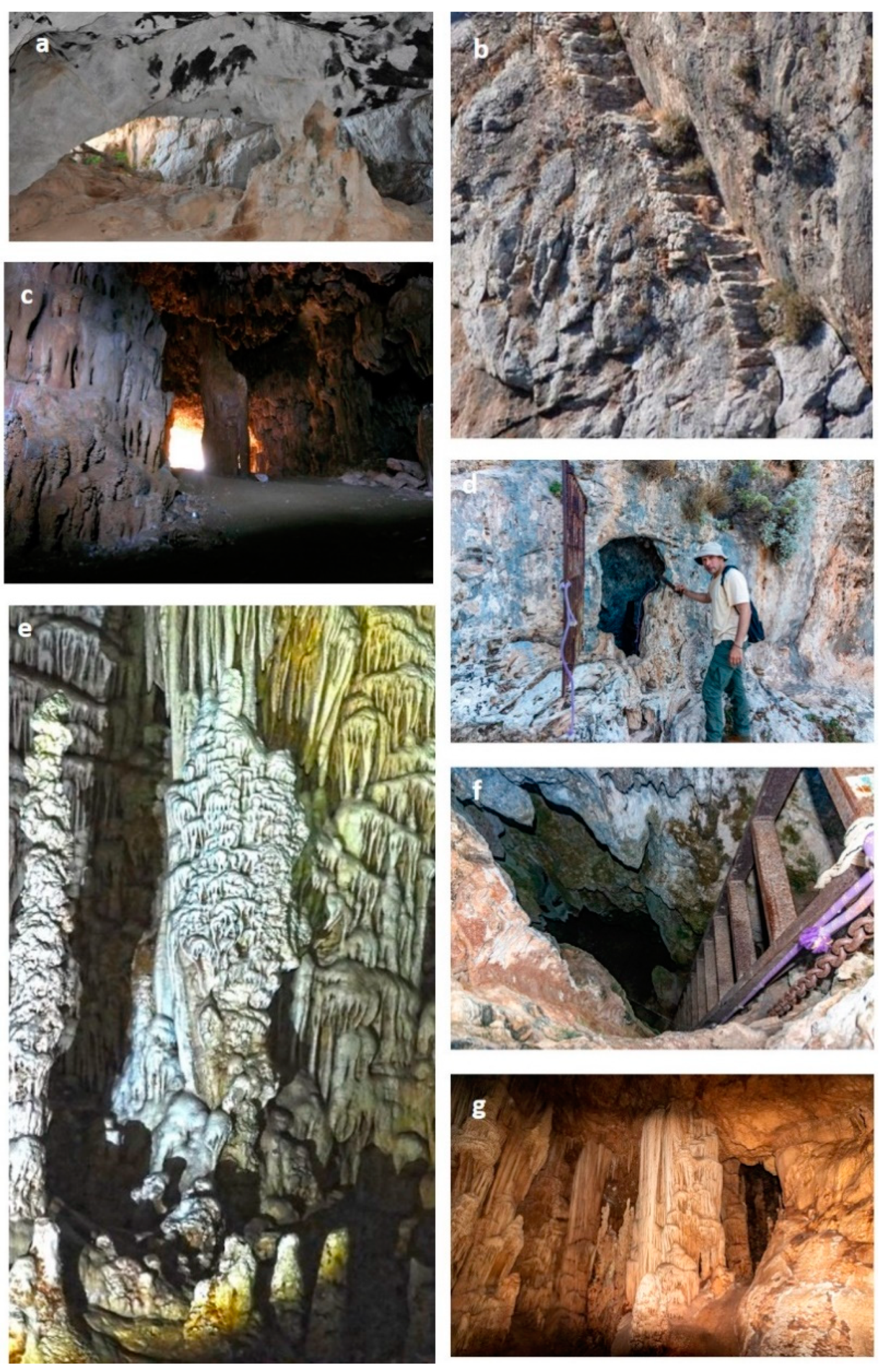
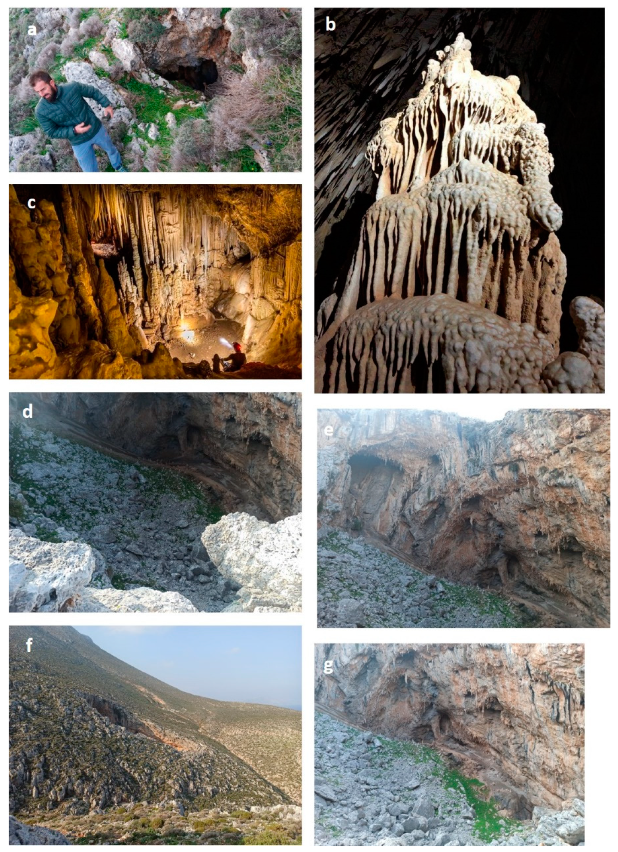
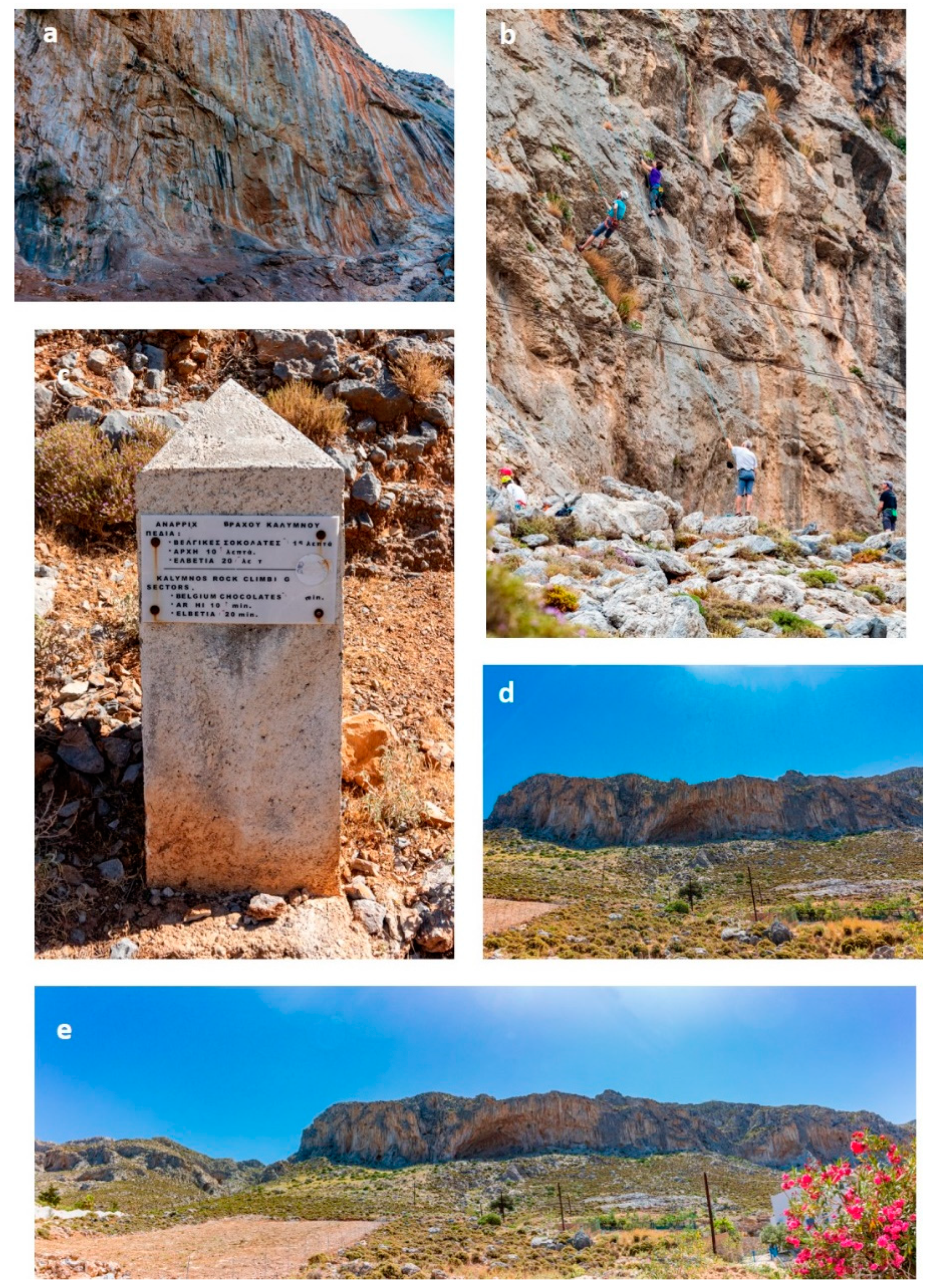
2.3. Geomorphosites
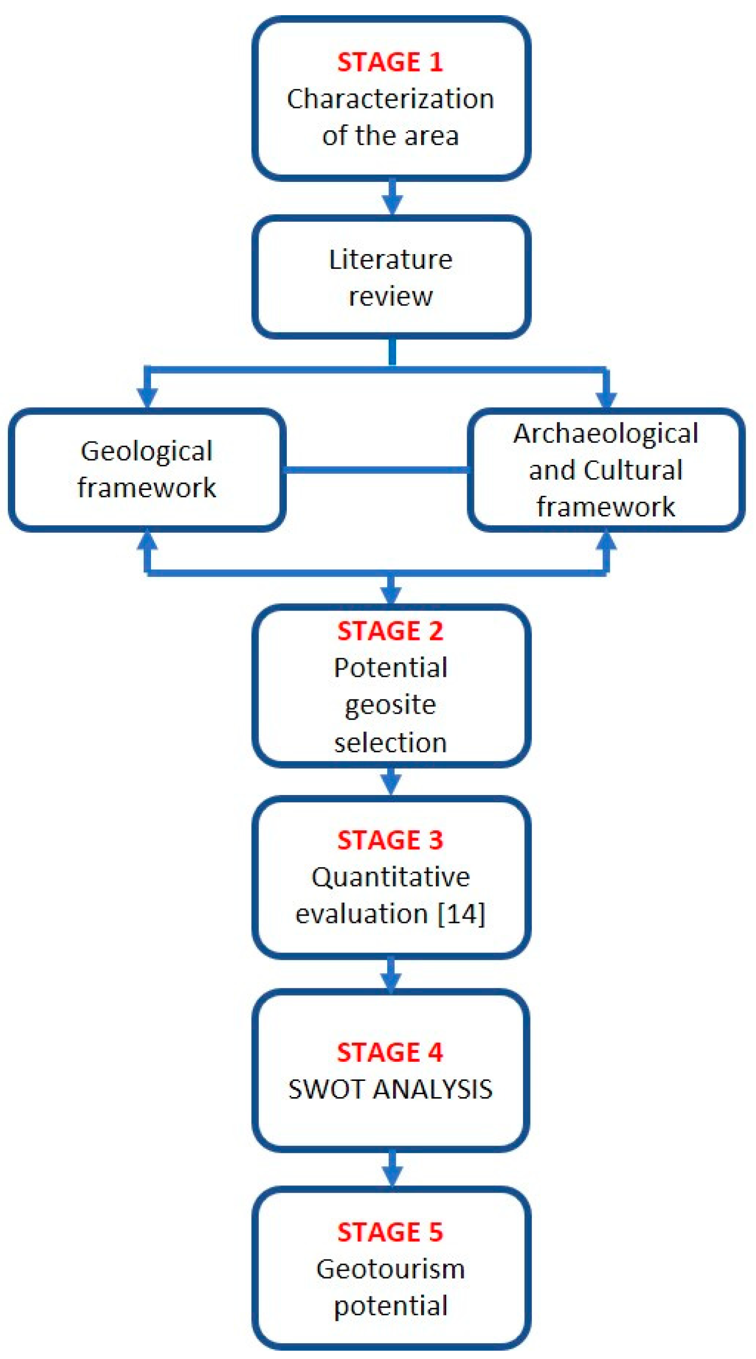
2.4. Methodology
3. Results and Discussion
3.1. Quantitative Evaluation of Geotourism Potential
3.2. Degradation Risk
3.3. SWOT Analysis
4. Conclusions
Author Contributions
Funding
Institutional Review Board Statement
Informed Consent Statement
Data Availability Statement
Acknowledgments
Conflicts of Interest
References
- Kokhan, T.A.; Zhirnova, E.V.; Lazutina, N.S.; Viniukova, E.A.; Mishurova, O.I. Development of tourism as a social phenomenon in the conditions of globalization. J. Environ. Manag. Tour. 2019, 10, 360–365. [Google Scholar] [CrossRef]
- Papadopoulou, G. Management models of tourism industry: The case of Greece. Open Sci. J. 2020, 5. [Google Scholar] [CrossRef] [Green Version]
- Belias, D.; Velissariou, E.; Kyriakou, D.; Varsanis, K.; Vasiliadis, L.; Mantas, C.; Sdrolias, L.; Koustelios, A. Tourism Consumer Behavior and Alternative Tourism: The Case of Agrotourism in Greece. In Innovative Approaches to Tourism and Leisure; Springer: Cham, Switzerland, 2018. [Google Scholar] [CrossRef]
- Ólafsdóttir, R.; Tverijonaite, E. Geotourism: A systematic literature review. Geosciences 2018, 8, 234. [Google Scholar] [CrossRef] [Green Version]
- Herrera-Franco, G.; Montalván-Burbano, N.; Carrión-Mero, P.; Apolo-Masache, B.; Jaya-Montalvo, M. Research trends in geotourism: A bibliometric analysis using the scopus database. Geosciences 2020, 10, 379. [Google Scholar] [CrossRef]
- Zafeiropoulos, G.; Drinia, H.; Antonarakou, A.; Zouros, N. From Geoheritage to Geoeducation and Geotourism: A special reference to Greece. Geosciences 2021, 11, 381. [Google Scholar] [CrossRef]
- Georgakopoulou, S.; Delitheou, V. Alternative forms of sustainable development: The case of thermal tourism. Int. J. Environ. Sustain. Dev. 2020, 19, 367–377. [Google Scholar]
- Karamani, P.; Drinia, H.; Panagiaris, G. Geotourism as a tool for the protection and promotion of the Cave of Galaxidi. In Proceedings of the 15th International Congress of the Geological Society of Greece Athens, Athens, Greece, 22 May 2019; pp. 22–24. [Google Scholar]
- Giannopoulos, I. Dodecanese, the genesis of a name and the italian approach. Eoa Kai Esperia 2006, 6, 275–296. [Google Scholar] [CrossRef] [Green Version]
- Koutellas Michaēl, I. Ta Byzantina Kai Metabyzantina Kastra Tis Kalymnou; Kalymniaka Chronika: Kalymnos, Greece, 2005; Volume 34, pp. 426–446. [Google Scholar]
- Volonakis, G. Ta Palaiochristianika Mnimia tis Nisou Telendou; Kalymniaka Chronika: Kalymnos, Greece, 1982; Volume 3, pp. 55–63. [Google Scholar]
- Simpson, R.H.; Lazenby, J.F. Notes from the Dodecanese III. Annu. Br. Sch. Athens 1973, 68, 127–179. [Google Scholar] [CrossRef]
- Higgins, M.D.; Higgins, R. A Geological companion to Greece and the Aegean. In The Dodecanese and the Carian Shore; Cornell University Press: Ithaca, NY, USA; Duckworth Publishers: London, UK, 1996. [Google Scholar]
- Chatziioannou, E.; Grasemann, B.; Schneider, D.; Hubmann, B.; Soukis, K. Variscan tectonics in Dodecanese, Kalymnos island, Greece. In Proceedings of the EGU General Assembly Conference Abstracts, Vienna, Austria, 12–17 April 2015. [Google Scholar]
- Katagas, C.; Sapountzis, E. Petrochemistry of low and medium grade mafic metamorphic rocks from Leros island, Greece. TMPM Tschermaks Miner. Petrog. Mitt. 1977, 24, 39–55. [Google Scholar] [CrossRef]
- Katagas, C.G. Metamorphic zones and physical conditions of metamorphism in Leros Island, Greece. Contrib. Miner. Petrol. 1980, 73, 389–402. [Google Scholar] [CrossRef]
- Durr, S. Die Karischen Inseln Zwischen Samos und Karpathos-Rhodos; Jacobshagen, V., Ed.; Geologie von Griechenland: Borntraeger, Berlin, Germany, 1986; pp. 180–187. [Google Scholar]
- Franz, L.; Okrusch, M.; Seidel, E.; Kreuzer, H. Polymetamorphic evolution of pre-Alpidic basement relics in the external Hellenides, Greece. Neues Jahrb. Fur Mineral. Abh. 2005, 181, 147–172. [Google Scholar] [CrossRef] [PubMed]
- Dürr, S. Über Alter und Geotektonische Stellung des Menderes-Kristallins/SW-Anatolien und Seine Äquivalente in der Mittleren Ägäis. Ph.D. Thesis, Habil. Univ., Marburg, Germany, Lahn, Germany, 1975; p. 106. [Google Scholar]
- Dürr, S.; Altherr, R.; Keller, J.; Okrusch, M.; Seidel, E. The Median Aegean Crystalline Belt: Stratigraphy, Structure, Metamorphism, Magmatism, Alps, Apennines, Hellenides; Closs, H., Roeder, D., Schmidt, K., Eds.; Schweizerbart: Stuttgart, Germany, 1978; pp. 455–477. [Google Scholar]
- Mimides, T.; Psomiadis, E.; Trikili, I. Monitoring land use changes and soil degradation using spot and temporal aerial photograph data-the case of Vathy basin (Kalymnos island-Dodecanese Greece). Bull. Geol. Soc. Greece 2007, 40, 1476–1484. [Google Scholar] [CrossRef] [Green Version]
- Maiuri, A. Esplorazione di Grotte con Avanzi Preistorici nell’Isola di Calimno; ClRh: Rhodos, Greece, 1928; Volume 1, pp. 110–117. [Google Scholar]
- Tsakiri, M.; Sigizis, K.; Billiris, H.; Dogouris, S. 3D laser scanning for the documentation of cave environments. In Proceedings of the 11th ACUUS International Conference-Underground Space: Expanding the Frontiers, Athens, Greece, 10–13 September 2007. [Google Scholar]
- Petrochilou, A. La grotte de Skalia, Kalymnos. Bull. Société Spéléologique Grece 1989, 19, 43–48. [Google Scholar]
- Brilha, J. Inventory and Quantitative Assessment of Geosites and Geodiversity Sites: A Review. Geoheritage 2016, 8. [Google Scholar] [CrossRef] [Green Version]
- Drinia, H.; Tsipra, T.; Panagiaris, G.; Patsoules, M.; Papantoniou, C.; Magganas, A. Geological heritage of syros island, cyclades complex, Greece: An assessment and geotourism perspectives. Geosciences 2021, 11, 138. [Google Scholar] [CrossRef]
- Fassoulas, C.; Mouriki, D.; Dimitriou-Nikolakis, P.; Iliopoulos, G. Quantitative Assessment of Geotopes as an Effective Tool for Geoheritage Management. Geoheritage 2012, 4, 177–193. [Google Scholar] [CrossRef]
- Cendrero, A. El patrimonio geológico. Ideas para su protección, conservación y utilización. In El patrimonio geológico. Bases para su valoración, protección, conservación y utilización; Serie Monografías del Ministerio de Obras Públicas, Transportes y Medio Ambiente; Ministerio de Obras Públicas, Transportes y Medio Ambiente: Madrid, Spain, 1996; pp. 17–27. [Google Scholar]
- Cendrero, A. Propuestas sobre criterios para la clasificación y catalogación del patrimonio geológico. In El patrimonio geológico.Bases para su valoración, protección, conservación y utilización; Serie Monografías del Ministerio de Obras Públicas; Ministerio de Obras Públicas, Transportes y Medio Ambiente: Madrid, Spain, 1996; pp. 29–38. [Google Scholar]
- Coratza, P.; Giusti, C. Methodological proposal for the assessment of the scientific quality of geomorphosites. Il Quaternario 2005, 18, 307–313. [Google Scholar]
- Pralong, J.P.; Reynard, E. A proposal for the classification of geomorphological sites depending on their tourist value. Quaternario 2005, 18, 315–321. [Google Scholar]
- Pereira, P.; Pereira, D.; Caetano Alves, M.I. Geomorphosite assessment in Montesinho Natural Park (Portugal). Geogr. Helv. 2007, 62, 159–168. [Google Scholar] [CrossRef] [Green Version]
- Reynard, E.; Fontana, G.; Kozlik, L.; Scapozza, C. A method for assessing scientific and adicional values of geomorphosites. Geogr. Helv. 2007, 62, 148–158. [Google Scholar] [CrossRef]
- Bruschi, V.M.; Cendrero, A. Direct and parametric methods for the assessment of geosites and geomorphosites. In Geomorphosites; Reynard, E., Coratza, P., Regolini-Bissig, G., Eds.; Verlag Dr. Friedrich Pfeil: München, Germany, 2009; pp. 73–88. [Google Scholar]
- Reynard, E. The assessment of geomorphosites. In Geomorphosites; Reynard, E., Coratza, P., Regolini Bissig, G., Eds.; Verlag Dr. Friedrich Pfeil: Munchen, Germany, 2009; pp. 63–71. [Google Scholar]
- Pereira, P.; Pereira, D.I. Methodological guidelines for geomorphosite assessment. Géomorphol. Relief Process. Environ. 2010, 16, 215–222. [Google Scholar]
- Bruschi, V.M.; Cendrero, A.; Albertos, J.A.C. A statistical approach to the validation and optimisation of geoheritage assessment procedures. Geoheritage 2011, 3, 131–149. [Google Scholar] [CrossRef]
- Pereira, P.; Pereira, D.I. Assessment of geosites tourism value in geoparks: The example of Arouca Geopark (Portugal). In Proceedings of the 11th European Geoparks Conference, Arouca, Portugal, 19–21 September 2012; pp. 231–232. [Google Scholar]
- Bollati, I.; Smiraglia, C.; Pelfini, M. Assessment and selection of geomorphosites and trails in the Miage Glacier area (Western Italian Alps). Environ. Manag. 2013, 51, 951–967. [Google Scholar] [CrossRef] [PubMed]
- Carcavilla, L.; López Martínez, J.; Durán Valsero, J.J. Patrimonio Geológico y Geodiversidad: Investigación, Conservación, Gestión y Relación Con Los Espacios Naturales Protegidos; Cuadernos del Museo Geominero: Madrid, Spain, 2007. [Google Scholar]
- Fuertes-Gutiérrez, I.; Fernández-Martínez, E. Mapping geosites for geoheritage management: A methodological proposal for the Regional Park of Picos de Europa (León, Spain). Environ. Manag. 2012, 50, 789–806. [Google Scholar] [CrossRef]
- Kirchner, K.; Kubalíková, L. Relief assessment methodology with respect to geoheritage based on example of the deblínská vrchovina highland. In Proceedings of the Public Recreation and Landscape Protection—With Man Hand in Hand? Brno, Czech Republic, 1–3 May 2013. [Google Scholar]
- Kubalíková, L.; Kirchner, K. Geosite and Geomorphosite Assessment as a Tool for Geoconservation and Geotourism Purposes: A Case Study from Vizovická vrchovina Highland (Eastern Part of the Czech Republic). Geoheritage 2016, 8, 5–14. [Google Scholar] [CrossRef]
- Nazaruddin, D.A. Systematic Studies of Geoheritage in Jeli District, Kelantan, Malaysia. Geoheritage 2017, 9, 19–33. [Google Scholar] [CrossRef]
- Ates, H.C.; Ateş, Y. Geotourism and Rural Tourism Synergy for Sustainable Development—Marçik Valley Case—Tunceli, Tur-key. Geoheritage 2018, 11, 207–215. [Google Scholar] [CrossRef]
- Lima, F.F. Proposta Metodológica Para Inventariação do Patrimônio Geológico Brasileiro. Dissertação (Mestrado em Patrimônio Geológico e Conservação); Universidade do Minho: Braga, Portugal, 2008. [Google Scholar]
- Mero, P.C.; Franco, G.H.; Briones, J.; Caldevilla, P.; Domínguez-Cuesta, M.J.; Berrezueta, E. Geotourism and Local Development Based on Geological and Mining Sites Utilization, Zaruma-Portovelo, Ecuador. Geosciences 2018, 8, 205. [Google Scholar] [CrossRef]
- Piacentini, T.; Miccadei, E.; Berardini, G.; Aratari, L.; De Ioris, A.; Calista, M.; Carabella, C.; D’Arielli, R.; Mancinelli, V.; Paglia, G.; et al. Geological tourist mapping of the Mount Serrone fault Geosite (Gioia dei Marsi, Central Apennines, Italy). J. Maps 2019, 15, 298–309. [Google Scholar] [CrossRef]
- Trikolas, K.; Ladas, I. The necessity of teaching earth sciences in secondary education. In Proceedings of the 3rd International GEOschools Conference, Teaching Geosciences in Europe from Primary to Secondary School, Athens, Greece, 28–29 September 2013; pp. 73–76. [Google Scholar]
- Fermeli, G.; Meléndez, G.; Calonge, A.; Dermitzakis, M.; Steininger, F.; Koutsouveli, A.; Neto de Carvalho, C.; Rodrigues, J.; D’Arpa, C.; Di Patti, C. GEOschools: Innovative teaching of geosciences in secondary schools and raising awareness on geoheritage in the society. In Avances y retos en la conservación del Patrimonio Geológico en España. Actas de la IX Reunión Nacional de la Comisión de Patrimonio Geológico (Sociedad Geológica de España); Fernández-Martínez, E., y Castaño de Luis, R., Eds.; Universidad de León: León, Spain, 2011; pp. 120–124. ISBN 978-84-9773-578-0. [Google Scholar]
- Georgousis, E.; Savelides, S.; Mosios, S.; Holokolos, M.V.; Drinia, H. The need for geoethical awareness: The importance of geoenvironmental education in geoheritage understanding in the case of meteora geomorphes, greece. Sustainability 2021, 13, 6266. [Google Scholar] [CrossRef]


| Caves | Climbing Field | ||||||||
|---|---|---|---|---|---|---|---|---|---|
| Scientific Criteria | Weight | Daskalio | Kefala | Choiromantres | Skalia | Stimenia | Sikati | Arginonta | Grande Grotta |
| Representativeness | 30 | 2 | 4 | 2 | 4 | 4 | 4 | 4 | 4 |
| Key locality | 20 | 1 | 1 | 1 | 1 | 1 | 1 | 1 | 1 |
| Scientific knowledge | 5 | 1 | 1 | 1 | 1 | 1 | 1 | 1 | 1 |
| Integrity | 15 | 4 | 4 | 1 | 4 | 4 | 4 | 4 | 4 |
| Geological diversity | 5 | 2 | 2 | 1 | 2 | 2 | 4 | 4 | 4 |
| Rarity | 15 | 1 | 1 | 1 | 1 | 1 | 4 | 4 | 4 |
| Use limitations | 10 | 4 | 4 | 4 | 4 | 1 | 4 | 4 | 4 |
| Total Score | 210 Moderate | 270 Moderate | 160 Low | 270 Moderate | 240 Moderate | 325 High | 325 High | 325 High | |
| Caves | Climbing Field | ||||||||
|---|---|---|---|---|---|---|---|---|---|
| Educational Criteria | Weight | Daskalio | Kefala | Choiromantres | Skalia | Stimenia | Sikati | Arginonta | Grande Grotta |
| Vulnerability | 10 | 4 | 4 | 4 | 4 | 4 | 4 | 4 | 4 |
| Accessibility | 10 | 3 | 4 | 4 | 4 | 3 | 3 | 4 | 4 |
| Use limitations | 5 | 3 | 4 | 4 | 4 | 1 | 2 | 4 | 4 |
| Safety | 10 | 3 | 4 | 1 | 3 | 2 | 2 | 4 | 4 |
| Logistics | 5 | 4 | 4 | 2 | 4 | 4 | 4 | 4 | 4 |
| Density of population | 5 | 4 | 4 | 4 | 4 | 4 | 4 | 4 | 4 |
| Association with other values | 5 | 4 | 4 | 4 | 2 | 4 | 2 | 2 | 2 |
| Scenery | 5 | 2 | 2 | 2 | 2 | 2 | 2 | 4 | 4 |
| Uniqueness | 5 | 3 | 2 | 2 | 2 | 2 | 2 | 2 | 2 |
| Observation conditions | 10 | 4 | 4 | 2 | 4 | 4 | 4 | 4 | 4 |
| Didactic potential | 20 | 3 | 3 | 3 | 3 | 3 | 3 | 3 | 3 |
| Geological diversity | 10 | 2 | 2 | 1 | 2 | 2 | 4 | 4 | 4 |
| Total score | 320 High | 340 High | 270 Moderate | 320 High | 295 Moderate | 310 High | 360 High | 360 High | |
| Caves | Climbing Field | ||||||||
|---|---|---|---|---|---|---|---|---|---|
| Touristic Criteria | Weight | Daskalio | Kefala | Choiromantres | Skalia | Stimenia | Sikati | Arginonta | Grande Grotta |
| Vulnerability | 10 | 4 | 4 | 4 | 4 | 4 | 4 | 4 | 4 |
| Accessibility | 10 | 3 | 4 | 4 | 4 | 3 | 3 | 4 | 4 |
| Use limitations | 5 | 3 | 4 | 4 | 4 | 1 | 2 | 4 | 4 |
| Safety | 10 | 3 | 4 | 1 | 3 | 2 | 2 | 4 | 4 |
| Logistics | 5 | 4 | 4 | 2 | 4 | 4 | 4 | 4 | 4 |
| Density of population | 5 | 4 | 4 | 4 | 4 | 4 | 4 | 4 | 4 |
| Association with other values | 5 | 4 | 4 | 4 | 2 | 4 | 2 | 2 | 2 |
| Scenery | 15 | 2 | 2 | 2 | 2 | 2 | 2 | 4 | 4 |
| Uniqueness | 10 | 3 | 2 | 2 | 2 | 2 | 2 | 2 | 2 |
| Observation conditions | 5 | 4 | 4 | 2 | 4 | 4 | 4 | 4 | 4 |
| Interpretative potential | 10 | 4 | 4 | 3 | 4 | 4 | 4 | 4 | 4 |
| Economic level | 5 | 1 | 1 | 1 | 1 | 1 | 1 | 1 | 1 |
| Proximity of recreational areas | 5 | 4 | 4 | 4 | 4 | 4 | 4 | 4 | 4 |
| Total Score | 320 High | 335 High | 275 Moderate | 315 High | 290 Moderate | 285 Moderate | 355 High | 355 High | |
| Caves | Climbing Fields | ||||||||
|---|---|---|---|---|---|---|---|---|---|
| Degradation Risk Criteria | Weight | Daskalio | Kefala | Choiromantres | Skalia | Stimenia | Sikati | Arginonta | Grande Grotta |
| Deterioration of geological features | 35 | 1 | 1 | 3 | 1 | 1 | 1 | 1 | 1 |
| Proximity to areas/activities with potential to cause degradation | 20 | 2 | 2 | 3 | 2 | 2 | 1 | 2 | 2 |
| Legal protection | 20 | 2 | 1 | 2 | 1 | 2 | 3 | 4 | 4 |
| Accessibility | 15 | 1 | 3 | 3 | 4 | 4 | 3 | 3 | 3 |
| Density of population | 10 | 4 | 4 | 4 | 4 | 4 | 4 | 4 | 4 |
| Total score | 170 Low | 180 Low | 290 Moderate | 195 Low | 215 Moderate | 200 Low/Moderate | 240 Moderate | 240 Moderate | |
| Strengths | Opportunities |
|
|
| Weaknesses | Threats |
|
|
Publisher’s Note: MDPI stays neutral with regard to jurisdictional claims in published maps and institutional affiliations. |
© 2021 by the authors. Licensee MDPI, Basel, Switzerland. This article is an open access article distributed under the terms and conditions of the Creative Commons Attribution (CC BY) license (https://creativecommons.org/licenses/by/4.0/).
Share and Cite
Zafeiropoulos, G.; Drinia, H. Kalymnos Island, SE Aegean Sea: From Fishing Sponges and Rock Climbing to Geotourism Perspective. Heritage 2021, 4, 3126-3146. https://doi.org/10.3390/heritage4040175
Zafeiropoulos G, Drinia H. Kalymnos Island, SE Aegean Sea: From Fishing Sponges and Rock Climbing to Geotourism Perspective. Heritage. 2021; 4(4):3126-3146. https://doi.org/10.3390/heritage4040175
Chicago/Turabian StyleZafeiropoulos, George, and Hara Drinia. 2021. "Kalymnos Island, SE Aegean Sea: From Fishing Sponges and Rock Climbing to Geotourism Perspective" Heritage 4, no. 4: 3126-3146. https://doi.org/10.3390/heritage4040175
APA StyleZafeiropoulos, G., & Drinia, H. (2021). Kalymnos Island, SE Aegean Sea: From Fishing Sponges and Rock Climbing to Geotourism Perspective. Heritage, 4(4), 3126-3146. https://doi.org/10.3390/heritage4040175