
“Underground Built Heritage”: A Theoretical Approach for the Definition of an International Class


Abstract
:
1. Introduction
2. Caves, Cavities and Underground Spaces: The Terminological Dilemma
3. “Cave” and “Underground” According to the UNESCO
3.1. “Cave”
3.2. “Underground”
3.3. The Failure of the Experiment and the Reason Why We Do Need the Definition “Underground Built Heritage”?
4. A Semantic Analysis of the Terms “Underground”, “Built” and “Heritage”
4.1. Underground
4.2. Built
4.3. Heritage
5. A Definition for UBH
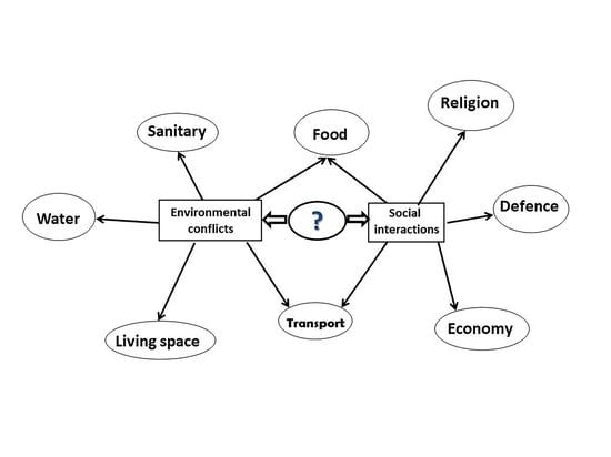
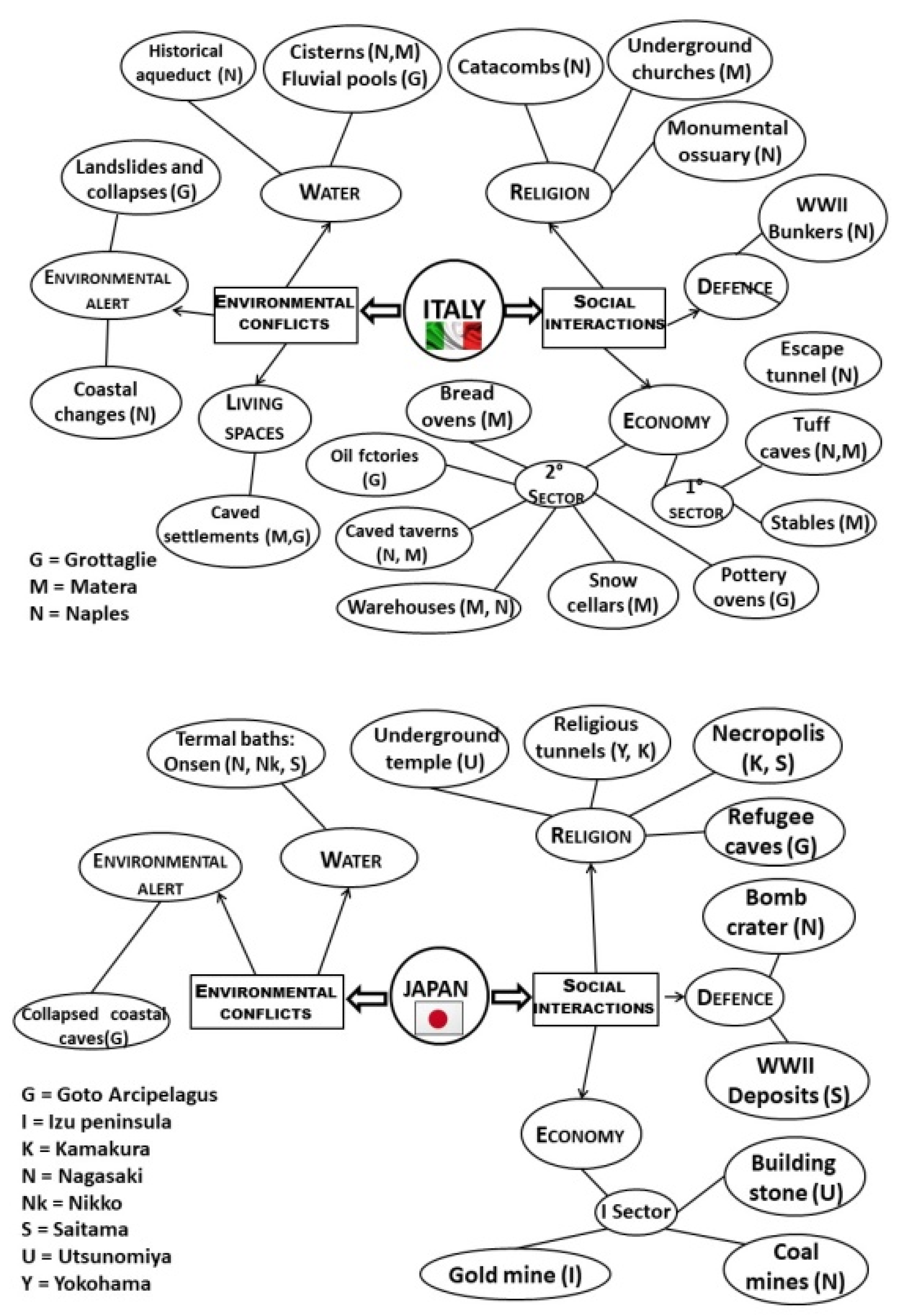
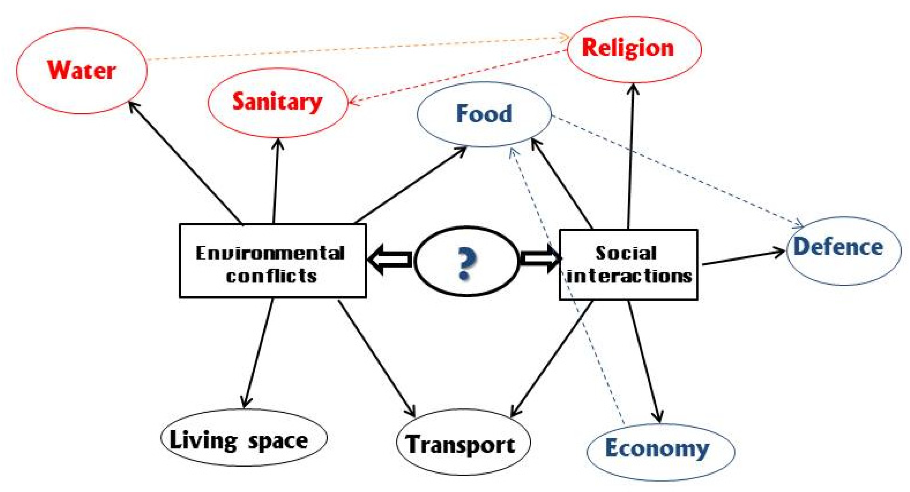
5.1. From Environmental Conflicts to Social Interactions: Eight Functions for UBH
5.1.1. Living Space
5.1.2. Water
5.1.3. Sanitary
5.1.4. Food
5.1.5. Religion
5.1.6. Defence
5.1.7. Economy
5.1.8. Transport
5.2. From Static to Dynamic Analysis
5.3. Levels of Re-Use for UBH
5.3.1. Re-Inventing Cultural UBH
5.3.2. Re-Introducing Old Functions in UBH
5.3.3. Re-Interpreting Historical Spaces of UBH
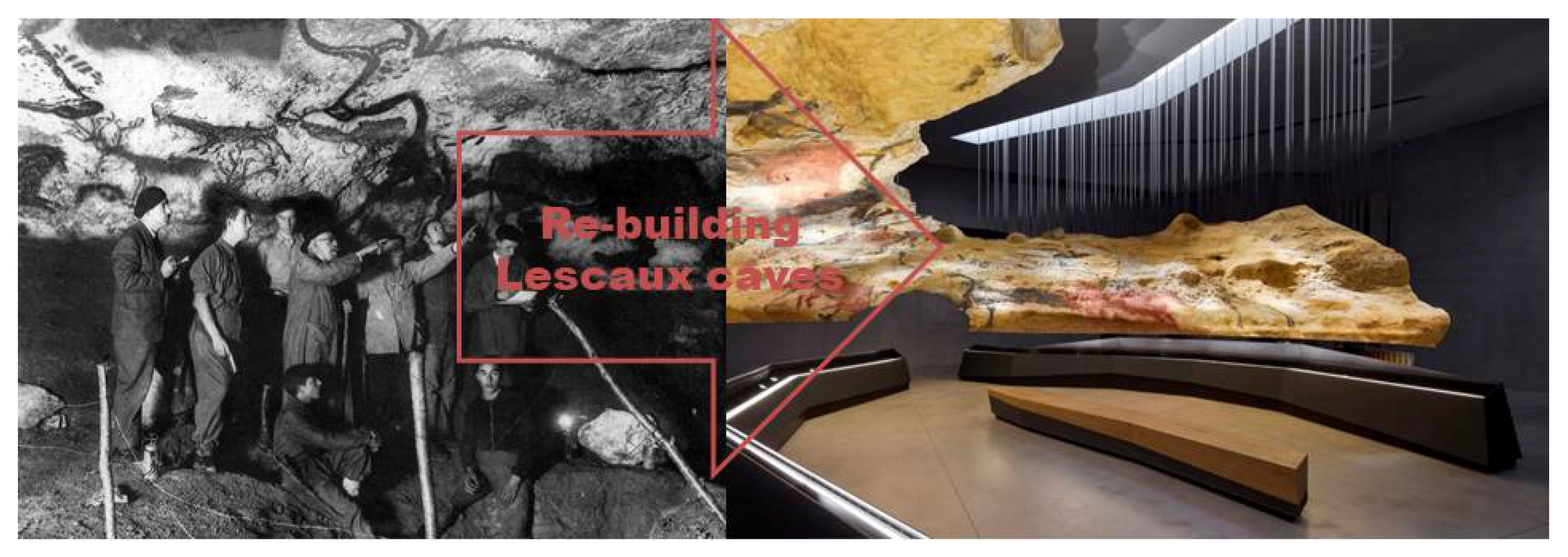
5.3.4. Re-Building UBH
6. Conclusions
Funding
Conflicts of Interest
References
- UNESCO. Convention on the Protection of the Underwater Cultural Heritage. 2001. Available online: http://portal.unesco.org/en/ev.php-URL_ID=13520&URL_DO=DO_TOPIC&URL_SECTION=201.html (accessed on 10 March 2021).
- Rau, M. The UNESCO convention on Underwater Cultural Heritage and the International Law of the Sea. In Max Planck Yearbook of United Nations Law; Springer: The Netherlands, 2002; Volume 6, pp. 387–472. [Google Scholar]
- Dromgoole, S. Underwater Cultural Heritage and International Law; Cambridge University Press: Cambridge, UK, 2013. [Google Scholar]
- Pace, G. Underground Built Heritage as catalyser for Community Valorisation. Underground4value. In Proceedings of the 55th ISOCARP (International Society of City and Regional Planners), World Planning Congress, Jakarta-Bogor, Indonesia, 9–13 September 2019; pp. 1250–1260. [Google Scholar]
- Fiore, S. I Segreti Della Napoli underground, Almanacco Della Scienza, N. 3–10 February 2021. Available online: http://www.almanacco.cnr.it/reader/cw_usr_view_articolo.html?id_articolo=10925&id_rub=32&giornale=10886 (accessed on 25 February 2021).
- Institute of Studies on the Mediterranean (ISMed). National Research Council of Italy (CNR). Available online: https://www.ismed.cnr.it/it/ (accessed on 25 February 2021).
- Varriale, R. (Ed.) Undergrounds in Naples. I Sottosuoli Napoletani; ISSM/CNR: Napoli, Italy, 2009. [Google Scholar]
- Urban Undergrounds in the Mediterranean, Modulo CNR. Available online: http://www.cnr.it/commesse/ModuloRisorseNuovo.html?id_mod=2376 (accessed on 25 February 2021).
- Varriale, R. Undergrounds in the Mediterranean: Ten urban functions from the “other” side of the Mediterranean cultural heritage in a long-term perspective. Glob. Environ. 2015, 7, 198–245. [Google Scholar]
- Le Risorse Naturali e le Fonti Storiche. Available online: https://www.ismed.cnr.it/it/le-risorse-naturali-e-le-fonti-storiche (accessed on 25 February 2021).
- Lapenna, V.; Leucci, G.; Parise, M.; Porfyriou, H.; Genovese, L.; Varriale, R. A project to promote the natural and cultural heritage of the underground environment in Southern Italy. In Proceedings of the International Conference of Speleology in Artificial Cavities, Cappadocia, Turkey, 6–10 March 2017; Parise, M., Galeazzi, C., Bixio, R., Yamac, A., Eds.; Dijital Düşler: Istanbul, Turkey, 2017; pp. 129d–133d. [Google Scholar]
- Bilateral Agreement CNR/CACH. Available online: https://www.cnr.it/en/bilateral-agreements/agreement/49/cach-chinese-academy-of-cultural-heritage (accessed on 10 March 2021).
- Valorizzazione, Turismo e Partecipazione Sociale. Sviluppo di Soluzioni Integrate Alternative Per siti Storici Meno Promossi. Available online: https://www.cnr.it/it/accordi-bilaterali/progetto/2297/valorizzazione-turismo-e-partecipazione-sociale-sviluppo-di-soluzioni-integrate-alternative-per-siti-storici-meno-promossi (accessed on 25 February 2021).
- Genovese, L.; Varriale, R.; Luvidi, L.; Fratini, F. Italy and China Sharing Best Practices on the Sustainable Development of Small Underground Settlements. Heritage 2019, 2, 53. [Google Scholar] [CrossRef] [Green Version]
- Varriale, R.; Genovese, L.; Luvidi, L.; Fratini, F. Identification and Interpretation of a Cultural Route: Developing Integrated Solutions of Enhancing the Vernacular Historic Settlements. In Proceedings of the ICOMOS—CIAV & ISCEAH 2019 Joint Annual Meeting & International Conference on Vernacular & Earthen Architecture towards Local Development, Pingyao, China, 6–8 September 2019; Yong, S., Jakhelln, G., Correia, M., Eds.; Tongji University Press: Shanghai, China, 2019; pp. 601–608. [Google Scholar]
- Bilateral Agreement CNR/JSPS. Available online: https://www.cnr.it/en/bilateral-agreements/agreement/14/jsps-japan-society-for-the-promotion-of-science (accessed on 10 March 2021).
- Monitoraggio del Rischio e Conservazione del Sottosuolo Antropico Come Risorse per le Attività Umane in Italia e Giappone (2018/2019). Available online: https://www.cnr.it/it/accordi-bilaterali/progetto/2945/monitoraggio-del-rischio-e-conservazione-del-sottosuolo-antropico-come-risorse-per-le-attivita-umane-in-italia-e-giappone (accessed on 1 March 2021).
- Varriale, R.; Oguchi, C.T.; Parise, M. (Eds.) Damage assessment and conservation of underground spaces as valuable resources for human activities in Italy and in Japan. Opera Ipogea. 2020. Special Issue. Available online: https://www.slideshare.net/CNR-ISSM/damage-assessment-and-conservation-of-underground-space-as-valuable-resources-for-human-activities-use-in-italy-and-japan-113917275 (accessed on 24 June 2021).
- Damage Assessment and Conservation of Underground Spaces as Valuable Resources for Human Activities in Italy and in Japan (2019/2020). Available online: https://www.cnr.it/it/accordi-bilaterali/final-report/1/jsps-giappone-2020-2021-final-report-signed.pdf (accessed on 1 March 2021).
- COST ACTION 18110. Available online: https://underground4value.eu/ (accessed on 3 March 2021).
- Padovan, G. Archeologia del Sottosuolo. Manuale per la Conoscenza del Mondo Ipogeo; Ugo Mursia Editore: Milano, Italy, 2009. [Google Scholar]
- Parise, M.; Galeazzi, C.; Bixio, R.; Dixon, M. Classification of artificial cavities: A first contribution by the UIS Commission. In Proceedings of the 16th International Congress of Speleology, Brno, Czech Republic, 21–28 July 2013; Filippi, M., Bosák, P., Eds.; Czech Speleological Society: Praha, Czech Republic; pp. 230–235. [Google Scholar]
- Plovdiv and Matera: European Capitals of Culture in 2019. Available online: https://www.europarl.europa.eu/news/en/headlines/society/20181205STO20960/plovdiv-and-matera-european-capitals-of-culture-in-2019 (accessed on 10 March 2021).
- Varriale, R. Re-Inventing Underground Space in Matera. Heritage 2019, 2, 70. [Google Scholar] [CrossRef] [Green Version]
- Varriale, R. A Methodological Framework for UBH classification. In Underground Built Heritage valorization. A Handbook. In Proceedings of the First Underground4value Training School, Naples, Italy, 10–15 February 2020; Pace, G., Salvarani, R., Eds.; CNR Edizioni: Roma, Italy, 2021; pp. 31–41. [Google Scholar]
- Varriale, R. A Methodological Framework for UBH Classification, News Letter COSTACTION 18110. Available online: http://underground4value.eu/wp-content/uploads/2020/06/Newsletter-may-5.pdf (accessed on 27 May 2021).
- International Union of Speleology (UIS). Available online: https://uis-speleo.org/ (accessed on 12 March 2021).
- UIS. The Caver’s Multi-Lingual Dictionary, Edition 19.1. Available online: http://www.uisic.uis-speleo.org/lexintro.html (accessed on 12 March 2021).
- Artificial Cavities Commission. Available online: https://artificialcavities.wordpress.com/ (accessed on 16 March 2021).
- Società Speleologica Italiana (SIS). Available online: http://www.speleo.it/site/index.php (accessed on 16 March 2021).
- Opera Ipogea. Available online: http://www.operaipogea.it/ (accessed on 16 March 2021).
- United Nations Educational, Convention Concerning the Protection of the World Cultural and Natural Heritage. Available online: https://whc.unesco.org/en/conventiontext/ (accessed on 17 March 2021).
- Slatyer, R.O. The Origin and Evolution of the World Heritage Convention. Ambio 1983, 12, 138–140. [Google Scholar]
- UNESCO List. Available online: https://whc.unesco.org/en/list/ (accessed on 17 March 2021).
- Vecco, M. A definition of cultural heritage: From the tangible to the intangible. J. Cult. Herit. 2010, 11, 321–324. [Google Scholar] [CrossRef]
- Lenzerini, F. Intangible Cultural Heritage: The Living Culture of Peoples. Eur. J. Int. Law 2011, 22, 101–120. [Google Scholar] [CrossRef]
- del Barrio, M.J.; Devesa, M.; Herrero, L.C. Evaluating intangible cultural heritage: The case of cultural festivals. City Cult. Soc. 2012, 3, 235–244. [Google Scholar] [CrossRef]
- Cante de Las Minas. Available online: https://festivalcantedelasminas.org/ (accessed on 25 June 2021).
- Shamai, S. Sense of place: An empirical measurement. Geoforum 1991, 22, 347–358. [Google Scholar] [CrossRef]
- Najafi, M.; Kamal, M.; Shariff, B.M. The Concept of Place and Sense of Place in Architectural Studies. Int. J. Hum. Soc. Sci. 2011, 6, 187–193. [Google Scholar]
- Smith, D. Pondering Privies: Construction, Use, Reuse, and Other Speculations about Cesspits in the Archaeological Record. J. Archaeol. Method Theory 2021, 28, 446–469. [Google Scholar] [CrossRef]
- Hicks, M. Underground Adventures. Health Hist. 2010, 12, 134–139. [Google Scholar] [CrossRef]
- La Cripta del Peccato Originale. Available online: https://www.criptadelpeccatooriginale.it/index.php?lang=it (accessed on 25 June 2021).
- Mogao Grottoes. Available online: https://www.mogaoku.net/ (accessed on 25 June 2021).
- Casa Vestita. Available online: https://www.tripadvisor.it/Attraction_Review-g1737518-d6990470-Reviews-Casa_Vestita-Grottaglie_Province_of_Taranto_Puglia.html (accessed on 25 June 2021).
- Passebois-Ducros, J. Innovation through Visitor Experience in Museums: The Case of the Lascaux Caves. In Innovation in the Cultural and Creative Industries; Pellegrin-Boucher, E., Roy, P., Eds.; ISTE Ltd.: London, UK, 2019; Volume 8, pp. 77–100. [Google Scholar]
- The Mine at the Deutsches Museum. Down into the Depths of the Underworld. Available online: https://www.munich.travel/en/topics/arts-culture/mine-deutsches-museum (accessed on 25 June 2021).


| Key Word | Number of Properties | Cultural | Natural | Mixed |
|---|---|---|---|---|
| cavity/cavities | 4 | 4 | ||
| cave | 131 | 83 | 31 | 17 |
| underground | 86 | 70 | 15 | 1 |
| N | Year | Country | Name of the Site | Type of Site | Type of Cave | Description | Use |
|---|---|---|---|---|---|---|---|
| 1 | 2003 (2003 D) | Afghanistan | Cultural Landscape and Archaeological Remains of the Bamiyan Valley | Cultural | Manmade | Buddhist monasteries, tunnels | R |
| 2 | 1974 | Algeria | Tassili n’Ajjer | Cultural/Natural | Natural | Burial mounds, rock art | B |
| 3 | 1999 | Argentina | Cueva de las Manos, Río Pinturas | Cultural | Natural | Cave art | A |
| 4 | 2000 | Armenia | Monastery of Geghard and the Upper Azat Valley | Cultural | Manmade | Churches and tombs cut into the rock | R/B |
| 5 | 1981 (87/92) | Australia | Kakadu National Park | Cultural/Natural | Natural | Cave paintings, rock carvings | A |
| 6 | 1982 (89) | Australia | Tasmanian Wilderness | Cultural/Natural | Natural | Caves occupied by humans | Sh |
| 7 | 1997 | Austria | Hallstatt-Dachstein/ Salzkammergut Cultural Landscape | Cultural | Manmade | Salt mines | M |
| 8 | 2007 | Azerbaijan | Gobustan Rock Art Cultural Landscape | Cultural | Natural | Rock art | A |
| 9 | 1998 | Bolivia | Fuerte de Samaipata | Cultural | Manmade | Sculptured rocks | A |
| 10 | 2001 | Botswana | Tsodilo | Cultural | Natural | Rock paintings, shelters and caves | A/C/ Sh |
| 11 | 1991 | Brazil | Serra da Capivara National Park | Cultural | Natural | Rock shelters, cave paintings | Sh/A |
| 12 | 2016 | Chad | Ennedi Massif: Natural and Cultural Landscape | Cultural/Natural | Natural | Rock art | A |
| 13 | 1995 | Chile | Rapa Nui National Park | Cultural | Not specified | Rock art in caves | A |
| 14 | 1987 | China | Mogao Caves | Cultural | Manmade | Cells and cave sanctuaries | R/B |
| 15 | 1987 | China | Peking Man Site at Zhoukoudian | Cultural | Natural | Human remains, fossils and rock art | Sh/A |
| 16 | 1990 | China | Mount Huangshan | Cultural/Natural | Natural | Caves (not applicable) | - |
| 17 | 1996 | China | Lushan National Park | Cultural | Deer Cave Academy (NO CAVE) | - | |
| 18 | 1999 | China | Dazu Rock Carvings | Cultural | Manmade | Cave temple art, rock carvings | R/A |
| 19 | 2000 | China | Longmen Grottoes | Cultural | Manmade | Caves and carved niches | R/B |
| 20 | 2001 | China | Yungang Grottoes | Cultural | Manmade | Buddhist cave art | R/B |
| 21 | 2006 | China | Yin Xu | Cultural | Manmade | Royal Tombs Area | B |
| 22 | 2009 | China | Mount Wutai | Cultural | Not specified | Caves | B/R |
| 23 | 2014 | China (trans) | Silk Roads: The Routes Network of Chang’an-Tianshan Corridor | Cultural | Manmade | Buddhist cave temples, tombs | R/B |
| 24 | 2018 | Colombia | Chiribiquete National Park–“The Maloca of the Jaguar” | Cultural/Natural | Natural | Rock shelters, rock art | Sh/A |
| 25 | 1995 | Czechia | Kutná Hora: Historical Town Centre, Church of St Barbara, Cathedral of Our Lady at Sedlec | Cultural | Manmade | Silver mines | M |
| 26 | 1978 | Ethiopia | Rock-Hewn Churches, Lalibela | Cultural | Manmade | Cave churches | R |
| 27 | 1991 | Finland | Old Rauma | Cultural | Manmade | Cellars | L |
| 28 | 1979 | France | Prehistoric Sites and Decorated Caves of the Vézère Valley | Cultural | Natural | Decorated caves | A/Sh |
| 29 | 1997 (99) | France (trans) | Pyrénées-Mont Perdu | Cultural/Natural | Natural | Prehistoric Caves | Sh |
| 30 | 1999 | France | Jurisdiction of Saint-Emilion | Cultural | Manmade | Monastic catacombs | R/B |
| 31 | 2001 | France | Provins, Town of Medieval Fairs | Cultural | Manmade | vaulted cellars and warehouses | C |
| 32 | 2014 | France | Decorated Cave of Pont d’Arc, known as Grotte Chauvet-Pont d’Arc, Ardèche | Cultural | Natural | Rock prehistoric art | A/Sh |
| 33 | 2015 | France | Champagne Hillsides, Houses and Cellars | Cultural | Manmade | Underground cellars | C |
| 34 | 2007 | Gabon | Ecosystem and Relict Cultural Landscape of Lopé-Okanda | Cultural/Natural | Natural | Caves and shelters, | C/Sh |
| 35 | 2017 | Germany | Caves and Ice Age Art in the Swabian Jura | Cultural | Natural | Caves with carved figurines | A/Sh |
| 36 | 1999 | Greece | The Historic Centre (Chorá) with the Monastery of Saint-John the Theologian and the Cave of the Apocalypse on the Island of Pátmos | Cultural | Manmade | Cave | R |
| 37 | 1987 | Hungary | Old Village of Hollókő and its Surroundings | Cultural | Manmade | Cellars | C |
| 38 | 1999 | Hungary | Hortobágy National Park-the Puszta | Cultural | Manmade | Burial mounds | B |
| 39 | 2002 | Hungary | Tokaj Wine Region Historic Cultural Landscape | Cultural | Manmade | Carved wine cellars | C |
| 40 | 1983 | India | Ajanta Caves | Cultural | Manmade | Cave monuments, decorated caves | R |
| 41 | 1983 | India | Ellora Caves | Cultural | Manmade | Buddhist cave monuments | R |
| 42 | 1983 | India | Taj Mahal | Cultural | Manmade | Group of rock-carved sanctuaries | R |
| 43 | 1984 | India | Group of Monuments at Mahabalipuram | Cultural | Manmade | Group of rock-carved sanctuaries | R |
| 44 | 1986 | India | Khajuraho Group of Monuments | Cultural | Manmade | Temple, partly rock-carved | R |
| 45 | 1987 | India | Elephanta Caves | Cultural | Natural | Rock art | A |
| 46 | 2004 | India | Champaner-Pavagadh Archaeological Park | Cultural | Manmade | Unexcavated archaeological remains | L |
| 47 | 2019 | India | Khangchendzonga National Park | Cultural/Natural | Natural | Caves | - |
| 48 | 2015 | Iran | Cultural Landscape of Maymand | Cultural | Manmade | Cave dwellings | Sh |
| 49 | 2012 | Israel | Sites of Human Evolution at Mount Carmel: The Nahal Me’arot/Wadi el-Mughara Caves | Cultural | Manmade | Burials and early stone architecture | B/R |
| 50 | 2014 | Israel | Caves of Maresha and Bet-Guvrin in the Judean Lowlands as a Microcosm of the Land of the Caves | Cultural | Manmade | Cave quarries | B/C |
| 51 | 1993 | Italy | The Sassi and the Park of the Rupestrian Churches of Matera | Cultural | Manmade | Troglodyte settlement | Sh |
| 52 | 2000 | Italy | Assisi, the Basilica of San Francesco and Other Franciscan Sites | Cultural | Natural | Caves occupied by Saint Francis | R |
| 53 | 2005 | Italy | Syracuse and the Rocky Necropolis of Pantalica | Cultural | Manmade | Rock-cut tombs | B |
| 54 | 2014 | Italy | Vineyard Landscape of Piedmont: Langhe-Roero and Monferrato | Cultural | Manmade | Cellars and storehouses | C |
| 55 | 2014 | Japan | Tomioka Silk Mill and Related Sites | Cultural | Manmade | Galleries | T |
| 56 | 2011 | Jordan | Wadi Rum Protected Area | Cultural/Natural | Natural | Rock art | A |
| 57 | 2015 | Jordan | Baptism Site “Bethany Beyond the Jordan” (Al-Maghtas) | Cultural | Manmade | Caves and pools | P |
| 58 | 2014 | Kazakhstan (trans) | Silk Roads: The Routes Network of Chang’an-Tianshan Corridor | Cultural | Manmade | Buddhist cave temples | - |
| 59 | 2009 | Kyrgyzstan | Sulaiman-Too Sacred Mountain | Cultural | Natural | Caves with petroglyphs | A |
| 60 | 2014 | Kyrgyzstan (trans) | Silk Roads: The Routes Network of Chang’an-Tianshan Corridor | Cultural | Manmade | Buddhist cave temples | - |
| 61 | 1998 | Lebanon | Ouadi Qadisha (the Holy Valley) and the Forest of the Cedars of God (Horsh Arz el-Rab) | Cultural | Manmade | Troglodyte habitat, natural and carved caves | Sh |
| 62 | 2013 | Lesotho (trans) | Maloti-Drakensberg Park | Cultural/Natural | Natural | Caves, rock shelters, pools | Sh/W |
| 63 | 1985 (2016 D) | Libya | Rock-Art Sites of Tadrart Acacus | Danger | Natural | Cave paintings | A |
| 64 | 2001 | Madagascar | Royal Hill of Ambohimanga | Cultural | Manmade | Burial site | B |
| 65 | 2012 | Malaysia | Archaeological Heritage of the Lenggong Valley | Cultural | Natural | Cave sites with Palaeolithic tool workshops | A/ Sh |
| 66 | 1989 | Mali | Cliff of Bandiagara (Land of theDogons) | Cultural/Natural | Natural | Sanctuaries | R |
| 67 | 1980 | Malta | Megalithic Temples of Malta | Cultural | Not applicable | Caved stones (not applicable) | - |
| 68 | 2008 | Mauritius | Le Morne Cultural Landscape | Cultural | Natural | Shelters, settlements | Sh |
| 69 | 1987 | Mexico | Pre-Hispanic City of Teotihuacan | Cultural | Not applicable | Excavations | - |
| 70 | 1988 | Mexico | Pre-Hispanic City of Chichen-Itza | Cultural | Manmade | Excavations, water facilities | W |
| 71 | 1999 | Mexico | Archaeological Monuments Zone of Xochicalco | Cultural | Manmade | Water system, disused mines | W/M |
| 72 | 2010 | Mexico | Camino Real de Tierra Adentro | Cultural | Manmade | Mines | M |
| 73 | 2010 | Mexico | Prehistoric Caves of Yagul and Mitla in the Central Valley of Oaxaca | Cultural | Natural | Prehistoric caves and rock shelters | Sh |
| 74 | 2010 | Mexico | Tehuacán-Cuicatlán Valley: Pristine habitat in Mesoamerica | Cultural/Natural | Manmade | Canals, wells, aqueducts and dams | W |
| 75 | 1979 | Norway | Urnes Stave Church | Cultural | Not applicable | Excavated elements | - |
| 76 | 1980 | Pakistan | Taxila | Cultural | Natural | Mesolithic cave | Sh |
| 77 | 1980 | Palau | Rock Islands Southern Lagoon | Cultural/Natural | Natural | Rock art | A |
| 78 | 2012 | Palestine | Birthplace of Jesus: Church of the Nativity and the Pilgrimage Route, Bethlehem | Cultural | Natural | Birthplace cave | Sh |
| 79 | 1992 | Peru | Río Abiseo National Park | Cultural/Natural | Natural | Rock shelters | Sh |
| 80 | 1980 | Poland | Historic Centre of Warsaw | Cultural | Not described | Not described | - |
| 81 | 1997 | Poland | Medieval Town of Toruń | Cultural | Manmade | Vaulted cellars | C |
| 82 | 1998 | Portugal (trans) | Prehistoric Rock Art Sites in the Côa Valley and Siega Verde | Cultural | Natural | Rock Art Sites | A |
| 83 | 2004 | Portugal | Landscape of the Pico Island Vineyard Culture | Cultural | Manmade | Wine-cellars | C |
| 84 | 1995 | Korea | Seokguram Grotto and Bulguksa Temple | Cultural | Natural | Buddhist temple in grotto | B |
| 85 | 1993 | Russian Fed | Architectural Ensemble of the Trinity Sergius Lavra in Sergiev Posad | Cultural | Not specified | Not specified | - |
| 86 | 2003 | Russian Fed | Citadel, Ancient City and Fortress Buildings of Derbent | Cultural | Not applicable | Excavations | - |
| 87 | 2008 | Saudi Arabia | Al-Hijr Archaeological Site (Madâin Sâlih) | Cultural | Manmade | Monumental tombs, cave drawings | B/A |
| 88 | 2012 | Senegal | Bassari Country: Bassari, Fula and Bedik Cultural Landscapes | Cultural | Natural | Natural caves | - |
| 89 | 1999 | South Africa | Fossil Hominid Sites of South Africa | Cultural | Natural | Archaeological caves | Sh |
| 90 | 2013 | South Africa (trans) | Maloti-Drakensberg Park | Cultural/Natural | Natural | Caves, rock shelters, pools | - |
| 91 | 1985 | Spain | Cave of Altamira and Palaeolithic Cave Art of Northern Spain | Cultural | Natural | Palaeolithic cave art | Sh/A |
| 92 | 1997 | Spain (trans) | Pyrénées-Mont Perdu | Cultural/Natural | Natural | Prehistoric caves | - |
| 93 | 1998 | Spain (trans) | Prehistoric Rock Art Sites in the Côa Valley and Siega Verde | Cultural | Natural | Rock-art sites | - |
| 94 | 1998 | Spain | Rock Art of the Mediterranean Basin on the Iberian Peninsula | Cultural | Natural | Rock art | A |
| 95 | 2000 | Spain | Archaeological Site of Atapuerca | Cultural | Natural | Fossil caves | Sh |
| 96 | 2016 | Spain | Antequera Dolmens Site | Cultural | Not specified | Not specified | - |
| 97 | 1991 | Sri Lanka | Rangiri Dambulla Cave Temple | Cultural | Natural | Cave-temple complex | R |
| 98 | 1992 | Thailand | Ban Chiang Archaeological Site | Cultural | Manmade | Excavated prehistoric settlement | Sh |
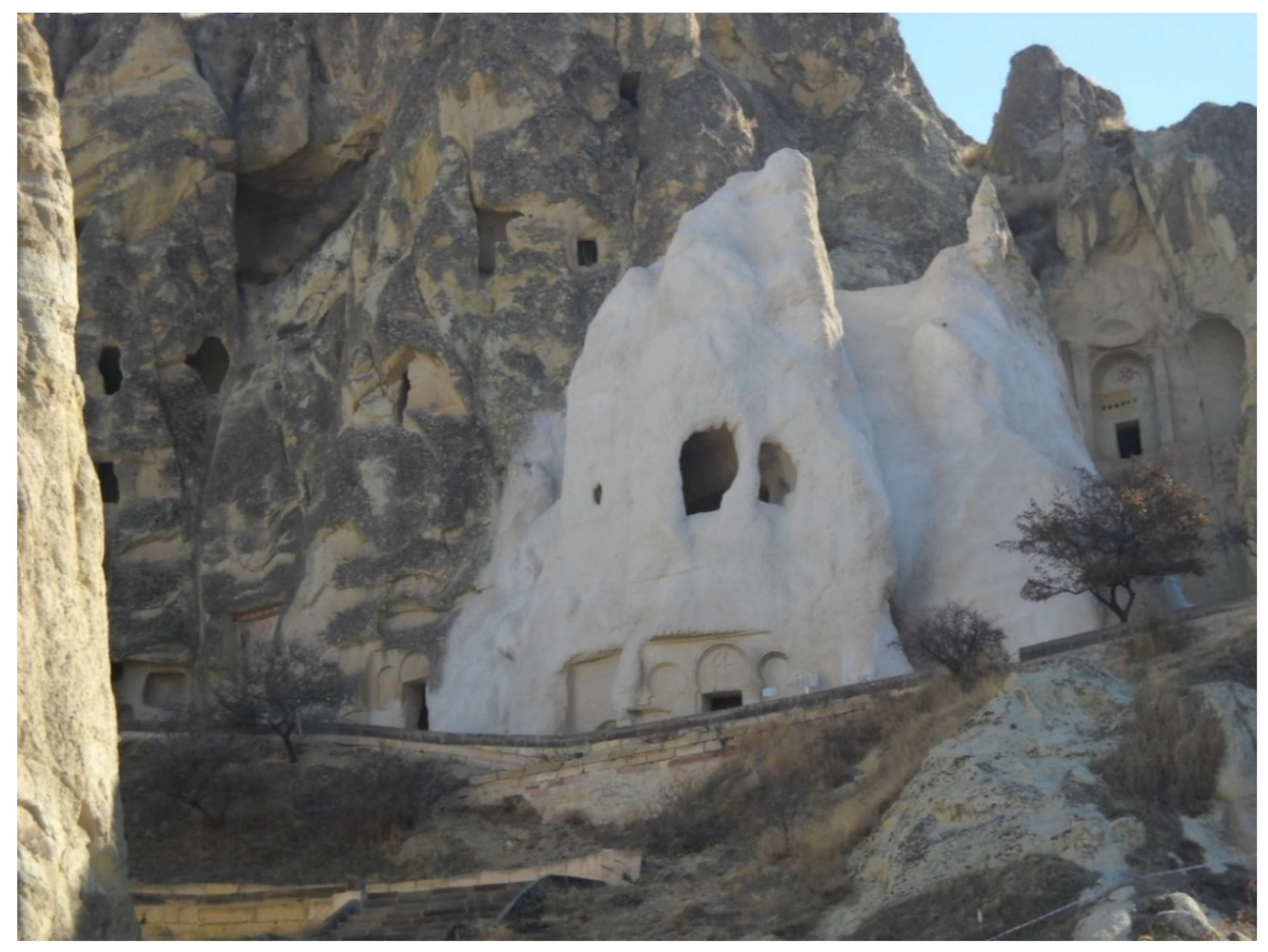
| 99 | 1985 | Turkey | Göreme National Park and the Rock Sites of Cappadocia | Cultural/Natural | Manmade | Cave cities | Sh |
| 100 | 2016 | Turkey | Archaeological Site of Ani | Cultural | Manmade | Tunnels and caves | T |
| 101 | 1990 | Ukraine | Kyiv: Saint-Sophia Cathedral and Related Monastic Buildings, Kyiv-Pechersk Lavra | Cultural | Manmade | Underground churches; burials | R/B |
| 102 | 1984 | UK | Gorham’s Cave Complex | Cultural | Natural | Archaeological caves | Sh |
| 103 | 2006 | UR Tanzania | Kondoa Rock-Art Sites | Cultural | Natural | Natural rock shelters, rock paintings | A/Sh |
| 104 | 2014 | Viet Nam | Trang An Landscape Complex | Cultural | Natural | Archaeological caves | Sh |
| 105 | 2003 | Zimbabwe | Matobo Hills | Natural shelters, rock paintings | A/Sh |
| N. | Year | Country | Name of the Site | Type of Site | Type of Cave | Description | Use |
|---|---|---|---|---|---|---|---|
| 1 | 2004 | Australia | Royal Exhibition Building and Carlton Gardens | Cultural | Manmade | Underground water tanks | W |
| 2 | 1997 | Austria | Hallstatt-Dachstein/Salzkammergut Cultural Landscape | Cultural | Manmade | Salt mines | M |
| 3 | 2000 | Belgium | Neolithic Flint Mines at Spiennes (Mons) | Cultural | Manmade | Ancient mines | M |
| 4 | 2012 | Belgium | Major Mining Sites of Wallonia | Cultural | Manmade | Coal-mining sites | M |
| 5 | 2000 | Bolivia | Tiwanaku: Spiritual and Political Centre of the Tiwanaku Culture | Cultural | Manmade | Underground drainage | W |
| 6 | 2017 | Brazil | Valongo Wharf Archaeological Site | Cultural | Manmade | Archaeological layers | L |
| 7 | 2006 | Chile | Sewell Mining Town | Cultural | Manmade | Underground copper mine | M |
| 8 | 2000 (03, 04) | China | Imperial Tombs of the Ming and Qing Dynasties | Cultural | Manmade | Tombs’ underground chambers | B |
| 9 | 2014 | China (trans) | Silk Roads: the Routes Network of Chang’an-Tianshan Corridor | Cultural | Manmade | Underground water channels | W |
| 10 | 1995 | Colombia | National Archeological Park of Tierradentro | Cultural | Manmade | Underground tombs | B |
| 11 | 2019 | Czekia (trans) | Erzgebirge/Krušnohoří Mining Region | Cultural | Manmade | Underground mine installations | M |
| 12 | 2004 | Republic of Korea | Complex of Koguryo Tombs | Cultural | Not applicable | No underground feature indicated | - |
| 13 | 1979 | Egypt | Memphis and its Necropolis–the Pyramid Fields from Giza to Dahshur | Cultural | Manmade | Underground archaeological remains | L |
| 14 | 1980 | Ethiopia | Aksum | Cultural | Manmade | Underground structures | L |
| 15 | 1982 (2009) | France | From the Great Saltworks of Salins-les-Bains to the Royal Saltworks of Arc-et-Senans, the Production of Open-pan Salt | Cultural | Manmade | Underground hydraulic gallery | W |
| 16 | 2012 | France | Nord-Pas de Calais Mining Basin | Cultural | Manmade | Underground coal seams | M |
| 17 | 2015 | France | Champagne Hillsides, Houses and Cellars | Cultural | Manmade | Underground cellars | C |
| 18 | 1987 (05, 08) | Germany (trans) | Frontiers of the Roman Empire | Cultural | Manmade | Underground archaeological remains | L |
| 19 | 1992 (2010) | Germany | Mines of Rammelsberg, Historic Town of Goslar and Upper Harz Water Management System | Cultural | Manmade | Tunnels and underground drains | W |
| 20 | 2004 | Germany | Town Hall and Roland on the Marketplace of Bremen | Cultural | Manmade | Underground wine cellars | C |
| 21 | 2014 | Germany | Carolingian Westwork and Civitas Corvey | Cultural | Manmade | Underground dwellings for guests and servants | Sh |
| 22 | 2019 | Germany (trans) | Erzgebirge/Krušnohoří Mining Region | Cultural | Manmade | Underground mine installations | - |
| 23 | 1996 | Greece | Archaeological Site of Aigai (modern name Vergina) | Cultural | Manmade | Underground tombs, underground museum | B |
| 24 | 1987 (2002) | Hungary | Budapest, including the Banks of the Danube, the Buda Castle Quarter and Andrássy Avenue | Cultural | Manmade | The European continent’s first underground railway | T |
| 25 | 1999 | Hungary | Hortobágy National Park-the Puszta | Cultural | NOT APPLICABLE | NO UNDERGROUND FEATURE MENTIONED | - |
| 26 | 2000 | Hungary | Early Christian Necropolis of Pécs (Sopianae) | Cultural | Manmade | Underground burial chambers | B |
| 27 | 2004 | Iceland | Þingvellir National Park | Cultural | Manmade | Hypothetical presence of underground remains | L |
| 28 | 1993 | India | Humayun’s Tomb, Delhi | Cultural | Manmade | Underground clay pipes | W |
| 29 | 2019 | Indonesia | Ombilin Coal Mining Heritage of Sawahlunto | Cultural | Manmade | Underground mining tunnels | M |
| 30 | 1979 | Iran | Tchogha Zanbil | Cultural | NOT APPLICABLE | NO UNDERGROUND FEATURE MENTIONED | - |
| 31 | 2004 (2007) | Iran | Bam and its Cultural Landscape | Cultural | Manmade | Underground irrigation canals | W |
| 32 | 2015 | Iran | Cultural Landscape of Maymand | Cultural | Manmade | Semi-underground houses | Sh |
| 33 | 2016 | Iran | The Persian Qanat | Cultural | Manmade | Underground water tunnels | W |
| 34 | 2017 | Iran | Historic City of Yazd | Cultural | Manmade | Qanat system, underground water | W |
| 35 | 2018 | Iran | Sassanid Archaeological Landscape of Fars Region | Cultural | NOT APPLICABLE | NO UNDERGROUND FEATURE MENTIONED | - |
| 36 | 2005 | Israel | Biblical Tels-Megiddo, Hazor, Beer Sheba | Cultural | Manmade | Underground water-collecting systems | W |
| 37 | 2014 | Israel | Caves of Maresha and Bet-Guvrin in the Judean Lowlands as a Microcosm of the Land of the Caves | Cultural | Manmade | Underground chambers | B |
| 38 | 1997 | Italy | Archaeological Area of Agrigento | Cultural | Manmade | Network of underground aqueducts | W |
| 39 | 1999 | Italy | Villa Adriana (Tivoli) | Cultural | Manmade | Cryptoportici and galleries | B |
| 40 | 1998 | Italy | Historic Centre of Urbino | Cultural | Manmade | NO UNDERGROUND FEATURE MENTIONED | - |
| 41 | 1987 | Italy | Archaeological Areas of Pompei, Herculaneum and Torre Annunziata | Cultural | Manmade | Archaeological excavations | L |
| 42 | 2000 | Japan | Gusuku Sites and Related Properties of the Kingdom of Ryukyu | Cultural | NOT APPLICABLE | NO UNDERGROUND FEATURE MENTIONED | - |
| 43 | 1985 | Jordan | Petra | Cultural | Manmade | Copper mines and underground galleries | M |
| 44 | 2014 | Kazakhstan (trans) | Silk Roads: the Routes Network of Chang’an-Tianshan Corridor | Cultural | Manmade | Underground water channels | - |
| 45 | 2014 | Kyrgyzstan (trans) | Silk Roads: the Routes Network of Chang’an-Tianshan Corridor | Cultural | Manmade | Underground water channels | - |
| 46 | 1986 (2016 D) | Libya | Old Town of Ghadamès | Cultural | Manmade | Underground network of passageways | T |
| 47 | 1980 | Malta | Ħal Saflieni Hypogeum | Cultural | Manmade | Underground cemetery | B |
| 48 | 1988 | Mexico | Historic Town of Guanajuato and Adjacent Mines | Cultural | Manmade | Underground mines, underground streets | M/T |
| 49 | 1988 | Mexico | Pre-Hispanic City of Chichen-Itza | Cultural | Manmade | Excavated underground ruins | L |
| 50 | 1985 | Morocco | Medina of Marrakesh | Cultural | Manmade | Underground drainage galleries | W |
| 51 | 1987 | Oman | Bahla Fort | Cultural | Manmade | Underground water channels | W |
| 52 | 2006 | Oman | Aflaj Irrigation Systems of Oman | Cultural | NOT APPLICABLE | NO UNDERGROUND FEATURE MENTIONED | - |
| 53 | 2014 (2014 D) | Palestine | Palestine: Land of Olives and Vines–Cultural Landscape of Southern Jerusalem, Battir | Cultural | NOT APPLICABLE | NO UNDERGROUND FEATURE MENTIONED | - |
| 54 | 1978 (08, 13) | Poland | Wieliczka and Bochnia Royal Salt Mines | Cultural | Manmade | Underground chapels and statues in the salt mines | M/R |
| 55 | 2017 | Poland | Tarnowskie Góry Lead-Silver-Zinc Mine and its Underground Water Management System | Cultural | Manmade | Underground mine and water management system | M/W |
| 56 | 2019 | Poland | Krzemionki Prehistoric Striped Flint Mining Region | Cultural | Manmade | Underground mining structures | M |
| 57 | 2003 | Russian Federation | Citadel, Ancient City and Fortress Buildings of Derbent | Cultural | Manmade | Several underground water reservoirs | W |
| 58 | 2012 | Slovenia (trans) | Heritage of Mercury. Almadén and Idrija | Cultural | Manmade | Underground mercury mines | M |
| 59 | 2011 | Spain | Cultural Landscape of the Serra de Tramuntana | Cultural | Manmade | Underground network for water management | W |
| 60 | 2012 | Spain (trans) | Heritage of Mercury. Almadén and Idrija | Cultural | Manmade | Underground mercury mines | - |
| 61 | 2019 | Spain | Risco Caido and the Sacred Mountains of Gran Canaria Cultural Landscape | Cultural | Manmade | Underground cisterns (troglodyte settlement) | W/ Sh |
| 62 | 1992 | Thailand | Ban Chiang Archaeological Site | Cultural | Manmade | Underground excavations | L |
| 63 | 1979 | Tunisia | Amphitheatre of El Jem | Cultural | Manmade | Underground passages | T |
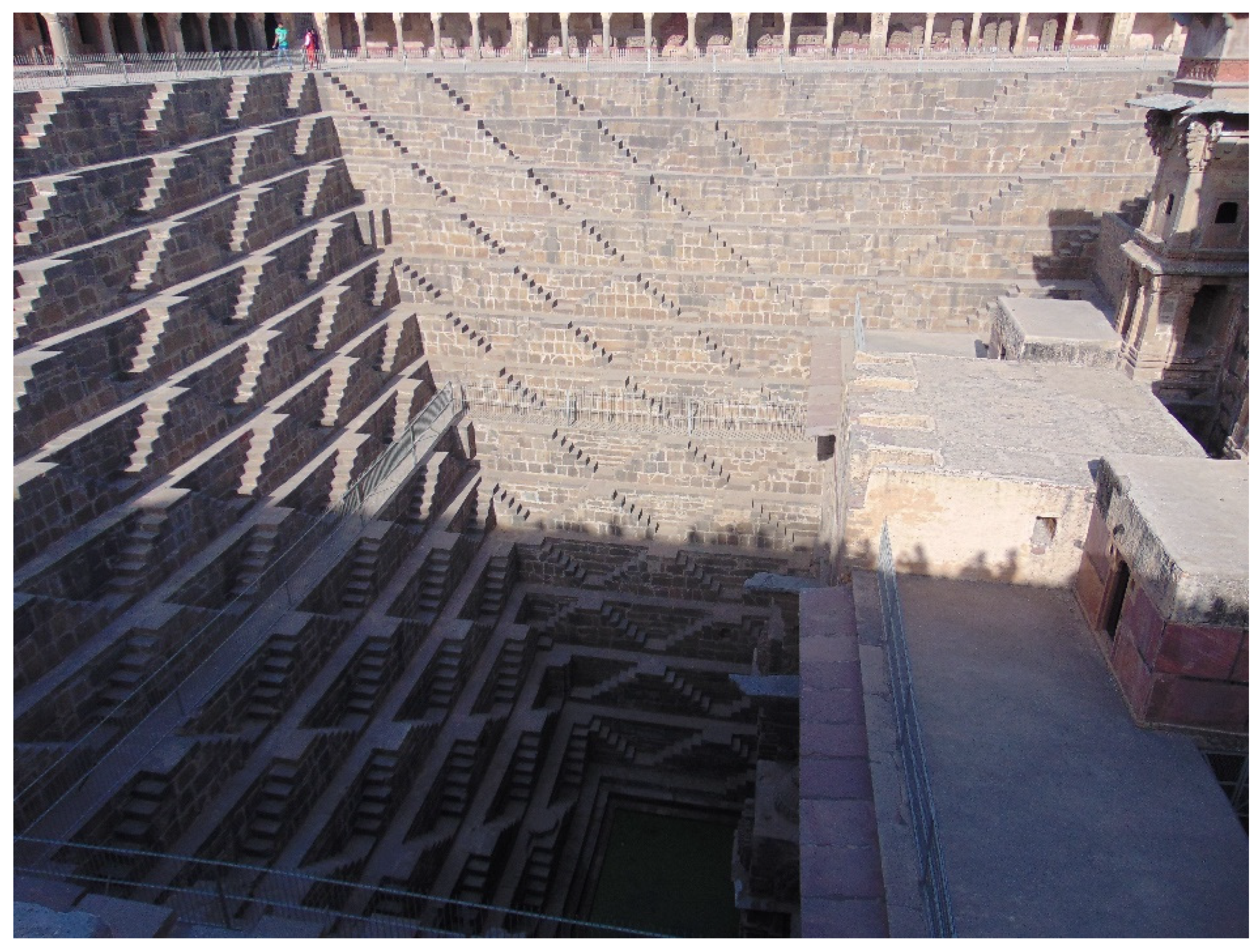
| 64 | 1985 | Turkey | Göreme National Park and the Rock Sites of Cappadocia | Cultural/Natural | Manmade | Underground towns (troglodyte villages) | Sh |
| 65 | 2016 | Turkey | Archaeological Site of Ani | Cultural | Manmade | Underground tunnels | T |
| 66 | 1999 | Turkmenistan | State Historical and Cultural Park “Ancient Merv” | Cultural | NOT APPLICABLE | NO UNDERGROUND FEATURE MENTIONED | - |
| 67 | 2011 | United Arab Emirates | Cultural Sites of Al Ain (Hafit, Hili, Bidaa Bint Saud and Oases Areas) | Cultural | Manmade | Underground irrigation systems | W |
| 68 | 1990 | Ukraine | Kyiv: Saint-Sophia Cathedral and Related Monastic Buildings, Kyiv-Pechersk Lavra | Cultural | Manmade | Underground churches | R |
| 69 | 1987 (05, 08) | UK (trans) | Frontiers of the Roman Empire | Cultural | Manmade | Underground archaeological remains | - |
| 70 | 1997 | UK | Maritime Greenwich | Cultural | Manmade | Underground archaeology | L |
| 71 | 2000 | UK | Blaenavon Industrial Landscape | Cultural | Manmade | Coal mine | M |
| 72 | 2006 | UK and Northern Ireland | Cornwall and West Devon Mining Landscape | Cultural | Manmade | Underground mines | M |
| 73 | 1992 | USA | Taos Pueblo | Cultural | Manmade | Underground ceremonial chambers | B |
| 74 | 1993 | Uzbekistan | Historic Centre of Bukhara | Cultural | NOT APPLICABLE | NO UNDERGROUND FEATURE MENTIONED | - |
| 75 | 2000 (2016 D) | Uzbekistan | Historic Centre of Shakhrisyabz | Cultural | Manmade | Network of underground conduits | W |
| 76 | 2011 | Viet Nam | Citadel of the Ho Dynasty | Cultural | NOT APPLICABLE | NO UNDERGROUND FEATURE MENTIONED | - |
| Site | Country | Name of the Plateau | Altitude | Latitude |
|---|---|---|---|---|
| Gharyan | Libya | Jabal Nafüsah | 700 metres a.s.l. | 32°10′ N |
| Matmata | Tunisia | Matmata Plateau | 600 metres a.s.l. | 33°32′ N |
| Sassi Matera | Italy | Murge Plateau | 401 metres a.s.l. | 40°40′ N |
| Kandovan | Iran | Iran/Persian Plateau | 2300 metres a.s.l. | 37°47′ N |
| Derinkuyu | Turkey | Anatolian Plateau | 1300 metres a.s.l. | 38°37′ N |
| Ürgup | Turkey | Anatolian Plateau | 1050 metres a.s.l. | 38°38′ N |
| Göreme | Turkey | Anatolian Plateau | 1104 metres a.s.l. | 38°38′ N |
| Avanos | Turkey | Anatolian Plateau | 920 metres a.s.l. | 34°42′ N |
| Lijiashan | China | Loess Plateau | 2628 metres a.s.l. | 36°52′ N |
| Guadix | Spain | Meseta Plateau | 949 metres a.s.l. | 37°17′ N |
Publisher’s Note: MDPI stays neutral with regard to jurisdictional claims in published maps and institutional affiliations. |
© 2021 by the author. Licensee MDPI, Basel, Switzerland. This article is an open access article distributed under the terms and conditions of the Creative Commons Attribution (CC BY) license (https://creativecommons.org/licenses/by/4.0/).
Share and Cite
Varriale, R. “Underground Built Heritage”: A Theoretical Approach for the Definition of an International Class. Heritage 2021, 4, 1092-1118. https://doi.org/10.3390/heritage4030061
Varriale R. “Underground Built Heritage”: A Theoretical Approach for the Definition of an International Class. Heritage. 2021; 4(3):1092-1118. https://doi.org/10.3390/heritage4030061
Chicago/Turabian StyleVarriale, Roberta. 2021. "“Underground Built Heritage”: A Theoretical Approach for the Definition of an International Class" Heritage 4, no. 3: 1092-1118. https://doi.org/10.3390/heritage4030061
APA StyleVarriale, R. (2021). “Underground Built Heritage”: A Theoretical Approach for the Definition of an International Class. Heritage, 4(3), 1092-1118. https://doi.org/10.3390/heritage4030061