Abstract
Urbanization has led to the degradation of green areas and natural resources, which are critical for preserving biodiversity and natural benefits. Sustainable urban development (SUD) practices aim to balance urbanization with preserving and protecting green land and natural resources to achieve greater sustainability. This study evaluated land suitability for SUD in the Nabatiyeh area of Lebanon using a multi-criteria decision analysis technique, the analytical hierarchy process, combined with a geographic information system. The elevations and slopes were the most important criteria, followed by the distances from urban agglomeration and industrial areas, accessibility, and land cover types, with corresponding weights of 34% and 36%, 12%, 9%, 6%, and 3%, respectively. The study created a suitability map for future SUD. This identification assists urban planners and policymakers in making informed decisions regarding the development of urban areas. The study’s findings highlight the efficiency of combining multi-criteria decision analysis with geospatial techniques for urban planning and environmental management in promoting sustainable development and protecting the environment. Future research could explore the possibility of integrating administrative reforms to promote SUD, including improving governance, enhancing the efficiency of governmental agencies responsible for urban development, building scientific capacities, and increasing officials’ accountability.
1. Introduction
Currently, urbanization has reached a high level, and more than half of the world’s population lives in urban agglomeration [1]. Generally, this is due to demographic growth and the socio-economic reasons that drive people to move from rural areas to urban agglomeration [2]. Consequently, this accelerated trend towards urbanization leads to serious environmental and ecological problems [2,3], such as air pollution, degradation of green areas, exhaustive use of natural resources, fragmentation of natural spaces, and biodiversity loss [4]. To face these problems, researchers develop several methods to regulate urban development to face unplanned urban growth and maintain sustainability. Thus, the main objective is explained as determining the best geographical locations for urban development and the locations of natural areas that should be preserved [5]. Therefore, effective land cover planning is essential for the identification of the best locations for sustainable urban growth [6,7].
Among several developed methods, land suitability analysis and the prediction of future urban growth emerge as the most efficient and commonly used methods [8]. These methods represent an effective informative tool to support policymakers and planners in developing optimal master plans, maintaining sustainability, and ensuring social equity among residents [9].
In other words, the land suitability analysis for sustainable urban development is characterized by categorizing lands according to their suitability for urban development or preservation as natural areas. Many land suitability assessments and analyses have been conducted for urban development [10], such as in Bangladesh [11] and in Tangshan City, China [12]. The majority of these studies have employed the Geographical Information System (GIS), which provides a mapping framework to undertake the activity of planning, coupled with the Multi-Criteria Decision Analysis (MCDA) to assess the land suitability for urban development [13,14]. The land suitability process for sustainable urban development is based on various sustainability criteria, such as environmental, social, and economic factors, coupled with regulating policies [3,15]. For instance, among the aspects that should be taken into account, the socio-economic, geophysical, and infrastructural factors represent the main criteria [16].
Out of the different MCDA methods used in several studies, the Analytical Hierarchy Process (AHP) represents one of the most commonly used methods. The AHP technique, developed by Saaty (1987) [17], is widely applied in different applicable scientific fields. Out of different uses, the AHP is commonly used in the analysis of land suitability for future urban development. The power of this technique could be depicted by its capability to determine the high and least suitable areas for urban development by taking into account different driving factors.
While the AHP method is often criticized because of its flaws, such as the subjectivity of judgments and its characteristic as a time-consuming method, it remains one of the most used methods to conduct raking comparison, especially in complicated multicriteria problematics.
For instance, a study based on GIS and AHP was conducted in 2021 to define suitable urban development areas in Indonesia’s Mamuju district. This study is considered beneficial for land developers and new residents and for the state by giving some guidance on suitable areas for land development since the study area is prone to the risks of floods, landslides, and earthquakes [18]. Additionally, a recent study was undertaken to assess the most suitable locations for sustainable urban development using the AHP in Eskisehir province in Turkey [19]. Similarly, several land suitability studies for urban development were conducted in different cities in India. In these studies, the AHP technique, consisting of a set of criteria involving geophysical and socio-economic variables, was used [20,21].
Additionally, the land suitability analysis can also be employed to establish strategies for developing agricultural productivity [22]. For instance, favorable lands for agricultural activities were identified by Ali Khan et al. (2022) [23] in the Punjab region in India by incorporating the AHP technique within the GIS environment. Similarly, the land suitability analysis for mango cultivation was investigated by Salunkhe (2022) [24] in Ratnagiri province in India. The well-suited locations for crop cultivation were also examined by combining the AHP with GIS techniques. A recent example is the study examining the land suitability for wheat cultivation in central Syria [25].
Furthermore, from an environmental point of view, the analysis to determine the suitable afforestation areas, based on combined GIS and AHP methods, which leads to more groundwater recharge, represents the focus of the studies of Yagci (2021) [26] in Konya province in Turkey and that conducted by Kadam (2021) [27] for Ghat province in India.
However, according to the recent and extensive scientific literature, sustainability was not taken in high priority into consideration in previous studies. In this context, it is questionable whether the MCDA, performed based on expert judgments coupled with remote sensing data, could grant the analysis of land suitability for SUD or not.
Then, this paper contributes to the emerging literature by taking into account sustainability as an essential issue to be integrated into the land suitability analysis. This issue could represent important guidance for decision-makers, especially when enacting urban masterplans.
This study aims to identify the land suitability for sustainable urban development in the Nabatiyeh region in Lebanon based on an MCDA methodology. The methodology combines the AHP with remote sensing data in a GIS environment. The outputs of this study are important since they could provide insight into the sustainable urban planning procedures in terms of pre-determining new locations for future sustainable urban development in the study area that witnessed the phenomenon of rapid and fragmented urban sprawl. The results will be in the form of a map presenting the most and least-suitable lands for sustainable urban development. This study also aims to show the significance of GIS and remote sensing applications in spatial decision-making for sustainable city development.
It is hypothesized that the availability of infrastructure and amenities and the accessibility to urban agglomerations and activities prevail over other factors affecting the sustainable development of new urban agglomeration. This hypothesis will be tested for validity within the analysis.
With regard to limitations, additional socio-economic factors, such as detailed population and employment densities, were not included in the study since they were not provided by official bodies due to the lack of information/census updates.
The paper is organized as follows: The Section 2 highlights the selection of the study area, the research methodology, and the data collection procedure. The Section 3 presents and discusses the results. In conclusion, the Section 4 summarizes the main findings of this study and presents the proposed topics for future research.
2. Materials and Methods
2.1. Study Area
In Lebanon, different districts, including the Nabatiyeh region, suffer from unplanned rapid urbanization and have experienced strong land cover dynamism [28]. In a more detailed way, the accelerated unplanned urbanization of the country, and especially in the southern part, including the Nabatiyeh region and its surrounding areas, occurred mainly in the period extending between the years 2005–2013 [29]. This specific period of accelerated and uncontrolled urban growth was spotted due to different political, security, economic, and immigration events of the country, mainly as (1) the Israeli withdrawal from the southern Lebanese region, (2) the conflict with Israel in 2006 and the post-Lebanon-Israel war reconstruction, (3) the influx of money deposits to Lebanese banks in 2008, and (4) the Syrian war and the immigration of Syrian refugees toward Lebanon as indicated by Al-Shaar and Bonin (2021) [30], in addition to limited planning regulations, and a lack of coordination between local and national governance [31]. In this context, it is noteworthy to consider the Israeli withdrawal from most southern Lebanese areas, as these areas returned to the control of the Lebanese state, which enabled the reconstruction and urbanization.
This rapid, extensive, and unplanned urbanization was behind the study area selection. Moreover, few studies examined the urban development in the country of the study area, but none of them discussed the land suitability for sustainable urban development. [32,33,34,35,36]. For instance, El Asmar et al. (2012) and Nader et al. (2008) presented, in their studies, a vision for sustainable urban planning and development in Lebanon that emphasizes community participation, sustainability, and stakeholder collaboration with the help of semi-structured interviews, municipality archive surveys, and open-ended questionnaires [32,33].
Pierre et al. (2013) discussed the difficulties Nabatiyeh, Lebanon, encountered with urban planning and growth both during and after times of violence. The authors highlighted an approach to urban planning and development that is comprehensive, open to participation, and encourages sustainable practices [34]. Tarraf-Najib (2001) investigated the municipality plans and policies for addressing topics, such as urban planning, accessibility to services, and economic development, in the Nabatiyeh area [35]. Makki Haidar (2005) investigated the elements driving rural urbanization, including demographic and economic change and how these factors affect the social and natural environment in Nabatiyeh [36]. The latter studies focus primarily on the relationship between urban development and various factors in Nabatiyeh without discussing the land suitability for sustainable urban development.
The said area comprises three urban villages: Nabatiyeh ElFaouka, Nabatiyeh ElTahata, and Kfar Remmane, with a total area of 29.76 km2 (Figure 1). The topographic form of the Nabatiyeh district is characterized by the presence of numerous hills (ranging in altitude from 300 to 950 m).
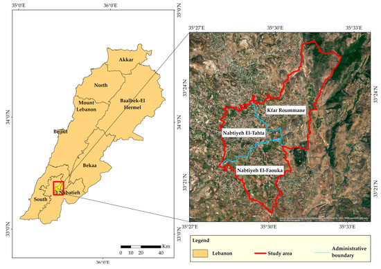
Figure 1.
Study area.
The study area is characterized by the presence of various land cover types with predominantly artificial (urban) and agricultural areas.
2.2. Developed Methodology
The aim of this study is depicted as conducting a land suitability analysis to define the most suitable sites for future sustainable urban growth. To this end, the adopted technical approach consists of (a) defining the criteria as the driving factors for sustainable urban development, (b) applying the AHP to weight criteria, (c) according to experts’ judgments, dividing the maps of each criterion to five classes: highest, high, moderate, low, and lowest suitability, and (d) using both the weights and classes of these criteria to generate a summary weighted overlay map (WOL) showing the overall land suitability.
Sustainability requires considering socio-economic and environmental aspects while choosing well-suited locations for future urban growth. Thus, the land suitability for SUD depends on several factors. For instance, topographic factors, such as slope and elevation, were found as some of the main driving factors for SUD in cities [19,37]. The accessibility to social activities and economic opportunities, represented by the distance from residential, commercial, and industrial areas, was also found as an essential element in defining the suitable location for SUD [13,38,39]. This requirement is highly provided by compact urban fabrics.
The provision of infrastructural utilities, such as road networks, also represents one of the main factors that affect the location of SUD [19,39].
Additionally, the preservation of natural resources is a crucial issue that should be highly taken into account when planning for sustainable development. Since the land cover distribution affects the environment and ecological protection, determining (a) suitable areas for sustainable urban development and (b) natural spaces that need to be preserved must be carried out [40,41]. Based on this literature review, the criteria used in this study are based on the following factors: (a) slope, (b) elevation, (c) road networks, (d) urban agglomeration, and (e) land cover.
The following graph (Figure 2) presents the methodology processes to generate the final spatial suitability map for sustainable urban development.
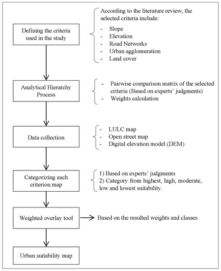
Figure 2.
The flow of methodology.
2.3. Data Collection
The data collection process for this study involved the collection and processing of various types of data from different sources. In particular, the land use/land cover map (LULC) was generated by the National Center for Remote Sensing in Lebanon (NCRS-L), using Spot satellite imagery with a spatial resolution of 1.5 m [42]. The LULC map for the year 2017 was prepared by applying a supervised maximum likelihood classification with reference to the Corine classification system [43]. Visual interpretation was employed to check the accuracy of the classification process. The results show an accuracy of 81% and a kappa value of 0.72 [42]. The LULC is used as a criterion for the MCDA method. The rasterized map for LULC was resampled to 10 m pixel size in ArcGIS.
The digital elevation model (DEM) with a spatial resolution of 30 m was obtained from the USGS Earth Explorer website [44]. This DEM was obtained from the Shuttle Radar Topography Mission (SRTM01) and was utilized to generate the elevation and slope maps using ArcMap 10.8 software. The DEM raster was then resampled to 10 m resolution.
Moreover, road network data were obtained from the OpenStreetMap website [45], and the road network shapefile was extracted to create a Euclidean distance map from the major and local roads. These maps are in the form of raster with 10 m resolution.
3. Suitability Analysis
3.1. Determining Criteria Weights Using the Analytical Hierarchy Process (AHP)
In this phase, the weight ranking of the proposed criteria, based on the AHP, is presented. Defining the pairwise comparison matrix, among the criteria factors, is a prerequisite for the AHP.
The pairwise comparison matrix was defined based on the expert’s judgments, where the experts conduct a comparison among all factors (one factor versus another one) according to their relative importance based on the Likert scale from 1 to 9 (please see Appendix A: Table A1).
Table 1 presents the criteria for a pairwise comparison matrix, defined according to experts’ judgments and statements via interviews [46,47,48,49,50].

Table 1.
Pairwise Comparison Matrix.
Based on the pairwise comparison matrix, the calculation of the final weights is conducted following the AHP process steps presented in Appendix A: Figure A1. Table 2 shows the weights of the used criteria.
Table 2.
Weighted criteria.
The consistency of the pairwise comparison matrix and the calculated weights argues that the consistency ratio (CR) must be less than 0.1 [51].
Referring to the calculations, consistency is ensured:
- -
- The principal eigenvalue (average of consistency vector), λmax = 6.59;
- -
- Consistency index: CI = (λmax – n)/(n − 1) = 0.12;
- -
- Consistency ratio: CR = CI/RI = 0.12/1.24 = 0.09
where RI is the Random Consistency Index, in which the value is given as 1.24 depending on the number of factors [52].
3.2. Defining and Classifying Criteria Classes
Sustainability requires taking the socio-economic and environmental aspects into account while identifying suitable locations for future urban growth [53]. In this study, five criteria were selected for evaluating land suitability. These criteria include slopes, elevations, road networks, urban agglomerations, and land cover. As a standardization system for all data, the map of each criterion was reclassified according to a scoring system from 1 to 5, with 1 representing the least suitable and 5 being the most suitable. Defining and classifying the criteria were based on both literature studies and expert judgments, which were obtained via interviews. Hence, several interviews were conducted with (a) real estate developers and contractors [48,49,50,54], (b) urban planning specialists and researchers [46,47], (c) engineers [55,56,57], and (d) local authority members: the mayor of Nabatiyeh region [58] and municipality members [59,60]. Concerning the topographic characteristics, such as slopes and elevations, the urban area should be located in fairly flat lands since landslides may potentially occur more in locations with steep slopes [61]. From an economic point of view, steep slopes are unfavorable for construction because of the elevated costs. In Lebanon, the majority of urban development occurred in the coastal areas in different cities where the elevation is less than 400 m [62]. Real estate developers revealed that they prefer constructing and developing new urban zones in locations in proximity to coastal lines. These areas represent the contiguous expansion of previous urban agglomerations in Lebanon [49,50], and this contiguity to urban agglomerations makes them more attractive for new residents and for companies.
These preferences would, to some extent, (a) ensure the preservation of natural and green areas occurring in higher zones, (b) prevent unorganized urban sprawl, and (c) promote urban sustainability [31]. The urban planning specialists [46,47] and engineers [55,56,57] stated that areas below 400 m are the most suitable areas for urban development in terms of social, environmental, and economic considerations. Additionally, the majority of the Lebanese cities are located near the coastal line, such as the cities of Beirut, Tripoli, Saida, and Tyre. Hence, the closer urbanizations are to coastal areas, the higher accessibility to (a) social amenities, such as health, educational, and entertainment services, and to (b) economic opportunities, such as commercial activities and employment, is provided. Areas with elevations less than 900 m are divided into four classes: (a) Highest suitability for areas with elevations ranging between 0 and 400 m, (b) High suitability for areas with elevations ranging between 400 and 600 m, (c) Moderate suitability for areas with elevations between 600 and 800 m, and (d) Low suitability for areas with elevations between 800 and 900 m [50,58]. Furthermore, the developers [55,56] revealed that areas with elevations more than 900 m are considered the lowest suitable for urban development. The classification of the slope map suggests that areas with slopes over 20% are not suitable for urban growth, as indicated by the experts in urban planning [46,47]; this is in the same line with previous literature findings that reveal that areas with a slope less than 20% are more suitable for urban development [37,63]. Areas with slopes less than 20% are classified into four classes: (a) Highest suitability for slopes ranging between 0 and 5%, (b) High suitability for slopes ranging between 5 and 10%, (c) Moderate suitability for slopes between 10 and 15%, and (d) Low suitability for slopes between 15–20% [48,50]. The provision of major roads and infrastructure contributes to enhancing the accessibility and connectivity between neighboring cities, providing social and economic opportunities for sustainable urban growth [64]. From an economic point of view, and for the sake of sustainable urban development, attempts must encourage urban growth closer to an existing road to reduce the additional cost of new roads. To retain effective connectivity between existing and future built-up areas in the study area, zones located within a distance less than 800 m from major and local roads are considered more suitable for the SUD [46,47,56]. Areas located at distances of more than 800 m are considered the least suitable for sustainable urban development. According to the expert judgments, these areas could be further divided into four classes: (a) Highest suitability for zones located within a distance less than 200 m, (b) High suitability for zones located between 200 and 400 m from roads, (c) Moderate suitability for zones located between 400 and 600 m from roads, and (d) Low suitability for zones located between 600 and 800 m from roads. During the planning phase of new urban development in a specific region, it is essential to consider the connectivity and compactness of different built-up areas. This can help (a) limit the urban sprawl, which is the uncontrolled dispersion of development within rural areas, and (b) benefit from the existing infrastructure and utilities, such as roads, water, drainage, sewerage and electrical networks, and other infrastructural systems [13]. This could reduce the environmental impacts of new developments and make it more sustainable in the long run [46,59]. Additionally, better connectivity can also promote economic growth and improve the quality of life for residents by providing easier access to services and amenities across the entire urban area [47,58]. A compact and well-planned urban area can provide a range of benefits for residents and help overcome the challenges of building sustainable cities [65,66]. In general, urban agglomerations refer to geographic areas consisting of densely populated urban centers and their surrounding suburbs. The national center for remote sensing in Lebanon has defined and divided the urban agglomeration of the study area into two categories: condensed and uncondensed urban agglomeration referring to high- and low-density urban agglomeration [37], as indicated in Figure 3. Jaffal (2022) and Harb (2022) [57,59] specified that new urban agglomeration should be located within a distance of less than 700 m from the closest urban agglomerations to ensure the sustainable aspect of new development. The experts indicated that areas located at distances of more than 700 m are considered the lowest suitable for sustainable urban development. Therefore, areas located within 700 m of urban agglomerations are divided into four classes: (a) Highest suitability for areas located within 100 and 300 m of urban agglomerations, (b) High suitability for areas located within 300 and 500 m of urban agglomerations, (c) Moderate suitability for areas located in distances less than 100 to urban agglomerations, and (d) Low suitability for areas located within 500 and 700 m to urban agglomerations.
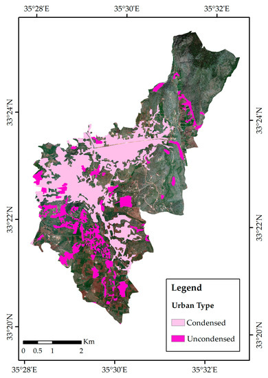
Figure 3.
Condensed and uncondensed urban agglomeration.
While certain industrial and commercial activities can generate noise, traffic, and pollution that may be disruptive to residential areas, the main activities of the study area are characterized by light industrial and commercial activities, which do not generate significant noise and pollution and do not also have a negative traffic impact. The industrial activities are limited to the food industry, textile and furniture manufacturing, and other unlisted industrial services. Commercial activities are only limited to retail services and do not encompass extensive urban logistics.
For instance, having commercial and industrial areas nearby to urban agglomerations is essential for accessibility to employment and opportunities, and to support local businesses, and improve access to goods and services. Additionally, having a mix of land use can create vibrant and vital neighborhoods [59]. Koubeissy (2022) and Ismail [47,58] stated that the most suitable areas for SUD are at a distance less than 900 m from the industrial and commercial areas. These areas are further classified into four classes: (a) Highest suitability for areas located with a buffer distance between 300 and 500 m to urban agglomeration, (b) High suitability for areas located between 500 and 700 m to urban agglomeration, (c) Moderate suitability for areas located in distances less 300 m away from urban agglomeration, and (d) Low suitability for areas located with distances ranging between 700 and 900 m.
The preservation and protection of ecosystems and natural resources are crucial for sustainable urban development. Uncontrolled urbanization and exhaustive development have depleted natural resources, pollution, and environmental degradation. Therefore, it is vital to ensure that future urban development is planned in a sustainable way that preserves the environment and natural resources. Hence, forests, green, and natural areas should be preserved and protected [13,67]. The LULC classification is reclassified depending on the LULC type. Thus, (a) High suitability (value 5) is assigned to unproductive bare soil and grass areas, (b) Moderate suitability (value 3) is assigned to the agricultural areas, and (c) Low suitability (value 1) the wooded and built-up areas [46,47].
The defined criteria classes are presented in Figure 4.
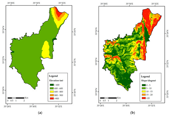
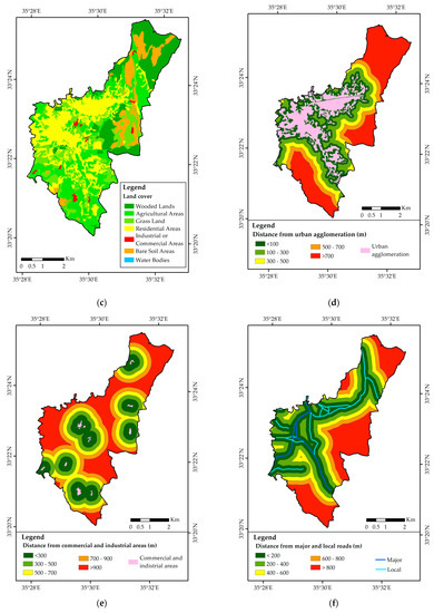
Figure 4.
Geo-processed and reclassified layers: (a) Elevation, (b) Slope, (c) Land cover map, (d) Buffer distance from urban agglomeration, (e) Buffer distance from commercial and industrial areas, and (f) Distance from major and local roads.
The final phase of the analysis is the generation of the suitability map. This process could be conducted by employing the weighted overlay (WOL) tool in the ArcMap software. This process consists of combining the data of (a) Weights of used criteria and (b) suitability classification maps of these criteria. These weights were derived using the AHP method and are presented in Table 2. Elevation and slope have the most important weights, with corresponding values of 0.34 and 0.36, respectively. The distance from urban agglomeration has moderate importance with a weight value of 0.12.
The least important criteria are the distance from industrial and commercial areas, the distance from main major and local roads, and the land cover types with weight values of 0.09, 0.06, and 0.03, respectively. These weights were then used to combine input classified maps of criteria into a single output layer representing the suitability map using the weighted overlay tool, which is included in ArcGIS software. The calculation consists of (a) multiplying the normalized values of each criterion layer (raster maps) by their respective weights, (b) summing up the resulting values of raster pixels, and (c) rounding the obtained values to have only integer ones.
4. Results and Discussion
The generated suitability map, presented in Figure 5a, shows the suitability degrees for the SUD. To highlight the suitable/non-suitable areas for future SUD, the existing built-up areas were retained from the analysis, as indicated in Figure 5b.
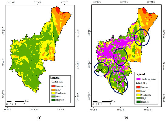
Figure 5.
Final suitability map of sustainable urban development in Nabatiyeh area; (a) without showing existing urban agglomeration; (b) showing existing urban agglomeration.
According to the findings presented in Figure 5b, zones with the highest degree of suitability are covering a small area of 0.11 km2, representing only 0.56% of the remaining unbuilt zones of the study area. Conversely, areas with high suitability extend over a larger area of 9.81 km2, representing 50.19% of the undeveloped lands. Areas with moderate suitability reach over 6.85 km2 or 29.38% of the undeveloped lands, whereas low suitability areas cover 0.63 km2, accounting for 17.87% of undeveloped lands. The areas with the lowest degree of suitability represent only 1.99% of the undeveloped areas, with a total area of 2.87 km2. Consequently, the study implies that future development projects could be implemented, generally, in areas with high and moderate suitability degrees for SUD since these zones have larger spatial extent. Figure 6 shows the percentages of suitability degrees relative to the non-built areas in the case study.
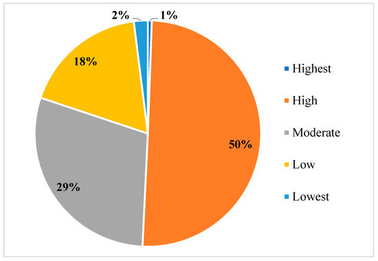
Figure 6.
Pie chart showing the percentages of suitability categories for future sustainable development.
According to the analysis, 64.11% of agriculture areas have the highest and high suitability degrees, with a total value of 5.09 km2. While 53.37% of bare soils and grass areas, equivalent to 3.8 km2, are considered as high and highly suitable lands. Moreover, 19.77% of the wooded areas, equivalent to 1.03 km2, are considered as high and highly suitable lands for SUD. A total of 35.64% of agriculture areas have a moderate suitability degree, with a total value of 2.83 km2. While 19.8% of bare soils and grass areas, equivalent to 1.41 km2, are considered moderately suitable lands. Moreover, 50.1% of the wooded areas, equivalent to 2.61 km2, are considered moderately suitable lands for SUD.
A total of 0.25% of agriculture areas have low and lowest suitability degrees, with a total value of 0.02 km2. While 26.83% of bare soils and grass areas, equivalent to 1.41 km2, are considered as low and least suitable lands. Moreover, 30.13% of the wooded areas, equivalent to 2.61 km2, are considered low and least suitable lands for SUD. It is noteworthy that this result is not in contradiction with the suitability values depicted in Table 3, but then other factors, mainly the slope, the distance from urban agglomeration, and main roads, would further affect this allocation rather than the land cover distribution.
Table 3.
Suitability values.
Table 4 shows the crosstabulation of low to high lands with land cover types.
Table 4.
Suitability degree area from future urban agglomeration.
Upon analyzing the land suitability map in Figure 5b and identifying the four indexed zones (A, B, C, and D) as the highly suitable areas for SUD, it is observed that areas with high suitability degrees are characterized by elevations ranging between 400 and 600 m, and by topographic slopes ranging between 0 and 10 degrees.
Zones A and D are located in proximity to the major roadway that links the study area to the principal coastal cities (Saida and Tyre) through the coastal highway. Additionally, the same road connects the study area to prominent mountain villages (Marjeyoun, Hasbaya, and Rachaya) in the opposite direction since the study area serves as an access crossing point to neighboring regions (Figure 7).
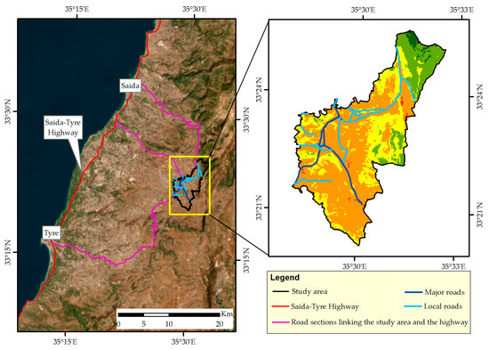
Figure 7.
The spatial location of the study area relative to the main nearby coastal cities.
Zone B is located in proximity to the main urban agglomeration and to local roads, resulting in higher levels of accessibility, more developed infrastructure, and a concentration of economic activities in addition to social and cultural amenities.
Zone C is located in proximity to industrial and commercial areas and to local roads that provide high accessibility to neighboring villages.
5. Conclusions
The expansion and densification of urban areas can contribute to the degradation of green areas and natural resources. These green spaces perform a critical role in preserving biodiversity and offering various natural benefits. Moreover, urbanization can increase the consumption of natural resources and lands, further impacting the natural environment. However, sustainable urban development practices aim to balance the needs of urbanization with the preservation and protection of green land and natural resources to achieve more sustainability.
It is vital to ensure that the environment is not harmed by future urban development and to keep a planet with sustainable natural resources for future generations.
This study contributes to the emerging literature by integrating sustainability into the land suitability analysis. This could represent an important guidance for decision-makers, particularly when authorizing strategies and developing zoning and urban masterplans. In detail, this analysis aims to evaluate the land suitability to identify the most suitable areas for sustainable urban development in the Nabatiyeh area, where there was a rise in an unplanned and accelerated phase of urbanization and sprawl during the past 20 years. The adopted methodology for this spatial assessment is based on using a multi-criteria decision analysis technique, the analytical hierarchy process, combined with a geographic information system that includes several suitability assessment criteria.
When determining suitable areas for sustainable urban expansion, it is crucial to consider socio-economic, environmental, and geophysical factors to achieve sustainability.
To this end, the scientific literature and expert judgments have identified several parameters that must be taken into account, including slope, elevation, land cover types, proximity to urban agglomerations, proximity to commercial and industrial zones, and accessibility to main roads. To obtain the data necessary for this assessment, the digital elevation model, land cover map, and road network were collected from different sources: the USGS Earth Explorer website, the National Center for Remote Sensing in Lebanon, and the OpenStreetMap database, respectively. According to expert judgments, and the literature indications in some cases, the analytical hierarchy process indicates that the elevations and slopes are the most important criteria to be considered, with corresponding weights of 34% and 36%, respectively. Additionally, a moderate importance weight value of 0.12 was assigned to the distances from urban agglomeration. Low values of criteria importance were assigned to the distance from industrial and commercial areas, the distance from main major and local roads, and the land cover types with weight values of 0.09, 0.06, and 0.03, respectively. The suitability map for future sustainable urban development has been created and categorized into five classes based on their degree of suitability. The analysis revealed that regions with high suitability accounted for 51% of the total undeveloped area; however, areas with moderate suitability are extended over 29%, and areas with low suitability degrees constitute 20% of the total undeveloped area.
The high and highest suitability areas identified in the land suitability map offer a promising opportunity for sustainable urban development, especially since they take into consideration the region’s topography, urban agglomeration, and existing infrastructure. This identification assists urban planners and policymakers in making informed decisions regarding the development of urban areas, ensuring that they are sustainable, efficient, and meet the needs of the population. Regarding the limitations, the neighboring villages were excluded from our study due to insufficient data. However, these villages share similar physical and socio-economic characteristics with the study area; hence, the findings would potentially be the same if these villages were included in the study area.
These findings illustrate the efficiency of combining multi-criteria decision analysis with geospatial techniques for urban planning and environmental management in promoting sustainable development and protecting the environment. This study offers vital information and insights for decision-makers on sustainable urban development using a multi-criteria decision analysis combined with geographic information systems and remote sensing, and it represents a necessary step toward sustainable growth and mitigation measures against natural degradation. With regard to future research, it is recommended in this context to study the possibility of integrating administrative reforms to promote the studies and implementation of sustainable urban development. These studies could be based on some practices of administrative reforms, including improved governance, consolidating, and enhancing the efficiency of governmental agencies and local authorities that are responsible for urban development, building more scientific capacities for the aforementioned entities, and increasing accountability of officials. Moreover, the existing land use and zoning master plan could be updated according to the land suitability map to provide more guidance toward sustainable development.
Author Contributions
Conceptualization, A.A.-G., W.A.-S. and A.E.; methodology, A.A.-G., W.A.-S. and M.A.-S.; software, A.A.-G.; validation, W.A.-S., G.F. and Y.A.; formal analysis, A.A.-G. and W.A.-S.; investigation, A.A.-G., W.A.-S. and Y.A.; resources, A.A.-G. and G.F.; data curation, A.A.-G., M.A.-S. and W.A.-S.; writing—original draft preparation, A.A.-G., M.A.-S. and W.A.-S.; writing—review and editing, W.A.-S., G.F. and A.E.; visualization, A.A.-G. and Y.A.; supervision, W.A.-S. and G.F.; All authors have read and agreed to the published version of the manuscript.
Funding
This research received no external funding.
Data Availability Statement
The data presented in this study are available on request from the corresponding authors.
Acknowledgments
Sincere gratitude to the CNRS-Lebanon for their technical and administrative support in providing us with the necessary data, which has been instrumental in our research.
Conflicts of Interest
The authors declare no conflict of interest.
Appendix A

Figure A1.
The steps followed in the AHP.
Table A1.
The Fundamental Scale [68].
Table A1.
The Fundamental Scale [68].
| Intensity of Importance | Description | Explanation |
|---|---|---|
| 1 | Equal importance | Two activities contribute equally to the objective |
| 3 | Moderate importance | Experience and judgment strongly favor one activity over another |
| 5 | Strong importance | Experience and judgment strongly favor one activity over another |
| 7 | Very strong importance | Activity is strongly favored, and its dominance demonstrated in practice |
| 9 | Extreme importance | The evidence favoring one activity over another is of tile highest possible order of affirmation |
| 2, 4, 6, 8 | “Intermediate” values between the two adjacent | When compromise is needed |
References
- Urbanization, Published online at OurWorldInData.org. 2018. Available online: https://ourworldindata.org/urbanization (accessed on 12 December 2022).
- U.N. World Urbanization Prospects: The 2018 Revision. United Nations, Department of Economic and Social Affairs, Population Division, New York. 2018. Available online: https://population.un.org/wup/Publications/Files/WUP2018-Report.pdf (accessed on 15 November 2022).
- Luan, C.; Liu, R.; Peng, S. Land-use suitability assessment for urban development using a GIS-based soft computing approach: A case study of Ili Valley, China. Eco. Ind. 2021, 123, 107333. [Google Scholar] [CrossRef]
- Huang, H.; Li, Q.; Zhang, Y. Urban Residential Land Suitability Analysis Combining Remote Sensing and Social Sensing Data: A Case Study in Beijing, China. Sustainability 2019, 11, 2255. [Google Scholar] [CrossRef]
- Schaefer, M.; Thinh, N.X. Evaluation of Land Cover Change and Agricultural Protection Sites: A GIS and Remote Sensing Approach for Ho Chi Minh City, Vietnam. Heliyon 2019, 5, e01773. [Google Scholar] [CrossRef] [PubMed]
- Masoudi, M.; Centeri, C.; Jakab, G.; Nel, L.; Mojtahedi, M. GIS-based multi-criteria and multi-objective evaluation for sustainable land-use planning (case study: Qaleh Ganj County, Iran) Landuse planning using MCE and Mola. Int. J. Environ. Res. 2021, 15, 457–474. [Google Scholar] [CrossRef]
- Ramya, S.; Devadas, V. Integration of GIS, AHP, and TOPSIS in evaluating suitable locations for industrial development: A case of Tehri Garhwal district, Uttarakhand, India. J. Clean Prod. 2019, 238, 117872. [Google Scholar] [CrossRef]
- Yang, X.; Khan, I. Dynamics among economic growth, urbanization, and environmental sustainability in IEA countries: The role of industry value-added. Environ. Sci. Pollut. Res. 2022, 29, 1–12. [Google Scholar] [CrossRef]
- Organisation for Economic Cooperation and Development. The Governance of Land Use; Organisation for Economic Cooperation and Development: Paris, France, 2017. [Google Scholar]
- Shah Pooja, B.; Sheladiya Kaushik, P.; Patel, J.; Patel, C.; Tailor, R. Assessing Land Suitability for Managing Urban Growth: An Application of GIS and RS. In Proceedings of the IGARSS 2020–2020 IEEE International Geoscience and Remote Sensing Symposium, 26 September–2 October 2020; pp. 4243–4246. [Google Scholar]
- Parvez, M.; Islam, S. Sites Suitability Analysis of Potential Urban Growth in Pabna Municipality Area in Bangladesh: AHP and Geospatial Approaches. J. Geogr. Sci. 2020, 3, 82–92. [Google Scholar] [CrossRef]
- Yang, Y.; Tang, X.; Li, Z. Land use suitability analysis for town development planning in Nanjing hilly areas: A case study of Tangshan new town, China. J. Mt. Sci. 2021, 18, 528–540. [Google Scholar] [CrossRef]
- Chen, S. Land-use suitability analysis for urban development in Regional Victoria: A case study of Bendigo. J. Geogr. Reg. Plann. 2016, 9, 47–58. [Google Scholar]
- Montgomery, B.; Dragicevic, S.; Dujmovic, J.; Schmidt, M. A GIS-based Logic Scoring of Preference method for evaluation of land capability and suitability for agriculture. Comput. Electron. Agric. 2016, 124, 340–353. [Google Scholar] [CrossRef]
- ElSayed, A. Land suitability analysis as multi-criteria decision making to support the Egyptian urban development. Int. J. Sci. Technol. Res. 2018, 1. [Google Scholar]
- Al-Shaar, W.; Bonin, O.; De Gouvello, B. Scenario-Based Predictions of Urban Dynamics in Île-de-France Region: A New Combinatory Methodologic Approach of Variance Analysis and Frequency Ratio. Sustainability 2022, 14, 6806. [Google Scholar]
- Saaty, R.W. The analytic hierarchy process—What it is and how it is used. Appl. Math. Model 1987, 9, 161–176. [Google Scholar] [CrossRef]
- Anastasia, S.; Alimuddin, I.; Arifin, F. Land suitability analysis for urban development using the multihazard map in MamujuMamuju district, West Sulawesi Province, Indonesia. IOP Conf. Ser. Earth Environ. Sci. 2021. [Google Scholar] [CrossRef]
- Deliry, S.; Uygucgil, H. GIS-Based land suitability analysis for sustainable urban development: A case study in Eskisehir, Turkey. Int. J. Sci. Eng. 2020, 20, 634–650. [Google Scholar]
- Parry, J.; Ganaie, S.; Bhat, S. GIS-based land suitability analysis using AHP model for urban services planning in Srinagar and Jammu urban centers of J&K, India. J. Urban Manag. 2018, 7, 46–56. [Google Scholar]
- Anugya, S.; Kumar, V.; Jain, K. Site Suitability Evaluation for Urban Development Using Remote Sensing, GIS, and Analytic Hierarchy Process (AHP). In Proceedings of International Conference on Computer Vision and Image Processing; Springer: Singapore, 2017; Volume 460. [Google Scholar]
- Pramanik, M.K. Site suitability analysis for agricultural land use of Darjeeling district using AHP and GIS techniques. Model. Earth Syst. Environ. 2016, 2, 1–22. [Google Scholar] [CrossRef]
- Ali Khan, M.; Ahmad, R.; Hasan Khan, H. Multi-criteria land suitability analysis for agriculture using AHP and Remote sensing Data for the Northern Region of India. In Geographic Information Systems and Applications in Coastal Studies; IntechOpen: Rijeka, Croatia, 2022. [Google Scholar]
- Salunkhe, S.; Nandgude, S.; Bhange, H. Land suitability analysis for Mango using the AHP method. Res. Sq. 2022. [Google Scholar]
- Khallouf, A.; Almesber, W.; Safwan, M. AHP and GIS-Based Land Suitability Analysis for Wheat Cultivation in Central Syria. Jordan J. Biol. Sci. 2021, 15. [Google Scholar]
- Yagci, C.; Iscan, F. GIS-based site suitability analysis of afforestation in Konya province Turkey. Turk. J. Earth Sci. 2021, 3, 89–95. [Google Scholar]
- Kadam, A.; Umrikar, B.; Bhagat, V.; Wagh, V.; Sankua, N. Land suitability analysis for afforestation in the semi-arid watershed of western Ghat, India: A groundwater recharge perspective. Geol. Ecol. Lands. 2021, 5, 136–148. [Google Scholar] [CrossRef]
- UN-Habitat Lebanon & ESCWA. State of the Lebanese Cities 2021, Beirut. Available online: https://unhabitat.org/un-habitat-lebanon-escwa-state-of-lebanese-cities-2021 (accessed on 3 November 2022).
- Verdeil, E.; Faour, G.; Hamzé, M. Atlas of Lebanon: New Challenges; Presses de l’Ifpo: Beirut, Lebanon, 2019. [Google Scholar]
- Al-Shaar, W.; Bonin, O. Factors behind the dynamics of land use evolution: The case of Lebanon. Springer Sci. Rev. 2021, 3, 677. [Google Scholar] [CrossRef]
- CDR. National Report on the Progress of the Implementation of the New Urban Agenda. 2021. Available online: https://www.urbanagendaplatform.org/sites/default/files/2022-04/NUA%20Draft%20Report.pdf (accessed on 18 April 2023).
- El Asmar, J.; Ebohon, J.; Taki, A. Bottom-up approach to sustainable urban development in Lebanon: The case of Zouk Mosbeh. Sustain. Cities Soc. 2012, 2, 37–44. [Google Scholar] [CrossRef]
- Nader, M.; Abi Salloum, B.; Karam, N. Environment and sustainable development indicators in Lebanon: A practical municipal level approach. Ecol. Indic. 2008, 8, 771–777. [Google Scholar] [CrossRef]
- Pierre, L.; Chapuis, J.; Faour, G. Nabatiyeh Dans les Guerres, Ville Refuge et Ville Fuie; EurOrient: Bondoufle, France, 2013. [Google Scholar]
- Tarraf-Najib, S. Action municipale, leadership et territoire: Nabatiyeh (Liban Sud). Munic. Et Pouvoirs Locaux Au Liban Les Cah. Du CERMOC. 2001, 24, 227–250. [Google Scholar]
- Haidar, S.M. La Mutation Socio-Urbaine des Zones Rurales: Aspects et Enjeux. Le cas de la ville de Nabatiyeh-Liban Sud, Research Paper, Master 2 in Sciences and Professions of the City, under the Supervision of L. Telvisian and J. Salamon. Ph.D. Thesis, Lebanese University, Lebanese Institute of Fine Arts, Department of Urbanism, Beirut, Lebanon, 2005. [Google Scholar]
- Santosh, C.; Krishnaiah, C.; Deshbhandari, P.G. Site suitability analysis for urban development using GIS-based multicriteria evaluation technique: A case study in Chikodi Taluk, Belagavi District, Karnataka, India. IOP Conf. Ser. Earth Environ. Sci. 2018, 169, 012017. [Google Scholar] [CrossRef]
- Abdelkarim, A.; Alogayell, H.; Alkadi, I.; Youssef, I. Mapping of GIS-Land Use Suitability in the Rural-Urban Continuum between Ar Riyadh and Al Kharj Cities, KSA Based on the Integrating GIS Multi-Criteria Decision Analysis and Analytic Hierarchy Process. Environments 2020, 7, 75. [Google Scholar] [CrossRef]
- Zhang, S.Y.; Jiang, D.; Liu, A.; Yu, H. Suitability Evaluation and Zoning of Construction Land for Suburban Villages and Towns Based on ESP and MCE Model: A Case Study in Qunfeng Town, Zhuzhou City, China. S2CID. For. Chem. Rev. 2021, 1801–1817. [Google Scholar]
- Hassan, M.M.; Nazem, M.N.I. Examination of land use/land cover changes, urban growth dynamics, and environmental sustainability in Chittagong city, Bangladesh. Environ. Dev. Sustain. 2016, 18, 697–716. [Google Scholar] [CrossRef]
- Dipeolu, A.A.; Ibem, E.O. Green infrastructure quality and environmental sustainability in residential neighborhoods in Lagos, Nigeria. Int. J. Urban Sustain. Dev. 2020, 12, 267–282. [Google Scholar] [CrossRef]
- National Center for Remote Sensing in Lebanon (NCRS). Land Cover Map 2017.
- CLC (Corine Land cover). Chief Inspectorate of Environmental Protection ul. Bitwy Warszawskiei; CLC: 2018. Available online: https://land.copernicus.eu/pan-european/corine-land-cover/clc2018 (accessed on 26 April 2023).
- Earth Explorer. Available online: https://earthexplorer.usgs.gov (accessed on 8 October 2022).
- Open Street Map (OSM). Available online: https://www.openstreetmap.org (accessed on 12 October 2022).
- Allaw, K. (Islamic University of Lebanon, Beirut, Lebanon). Personal communication, 2022.
- Koubeissy, A. (Islamic University of Lebanon, Beirut, Lebanon). Personal communication, 2022.
- Cherkawi, B. (Real estate developer and contractor, Nabatiyeh, Lebanon). Personal communication, 2022.
- Hammoud, M. (Real estate developer and contractor, Nabatiyeh, Lebanon). Personal communication, 2022.
- Mouazen, A. (Real estate developer and contractor, Nabatiyeh, Lebanon). Personal communication, 2022.
- Saaty, T.L. Decision making with the analytic hierarchy process. Int. J. Serv. Sci. 2008, 1, 83–98. [Google Scholar] [CrossRef]
- Alonso, J.; Lamata, M. Consistency in the Analytic Hierarchy Process: A New Approach. Int. J. Uncertain. Fuzziness Knowlege-Based Syst. 2006, 14, 445–459. [Google Scholar] [CrossRef]
- Aburas, M.M.; Abdullah, S.H.; Ramli, M.F.; Asha’ari, Z.H. Land suitability analysis of urban growth in Seremban Malaysia, using GIS-based analytical hierarchy process. Procedia Eng. 2017, 198, 1128–1136. [Google Scholar] [CrossRef]
- Younes, M. (Real estate developer and contractor, Nabatiyeh, Lebanon). Personal communication, 2022.
- Eldor, S. (Civil engineer, Nabatiyeh, Lebanon). Personal communication, 2022.
- Ellhaf, J. (Geomatics engineer, Nabatiyeh, Lebanon). Personal communication, 2022.
- Jaffal, M. (Civil engineer, Nabatiyeh, Lebanon). Personal communication, 2022.
- Ismail, W. (Mayor, Zawtar ElCharkieh, Nabatiyeh, Lebanon). Personal communication, 2022.
- Harb, C. (Municipality member, Nabatiyeh, Lebanon). Personal communication, 2022.
- Harb, H. (Municipality member, Nabatiyeh, Lebanon). Personal communication, 2022.
- Yang, C.; Zeng, W. The Correlation of Geo-Ecological Environment and Mountain Urban Planning. IOP Conf. Ser. Earth Environ. Sci. 2018, 108, 032081. [Google Scholar] [CrossRef]
- Faour, G.; Mhawej, M. Mapping Urban Transitions in the Greater Beirut Area Using Different Space Platforms. Land 2014, 3, 941–956. [Google Scholar] [CrossRef]
- AlFanatseh, A. Land suitability analysis of urban development in the Aqaba area, Jordan, using a GIS-based analytic hierarchy process. GeoJournal 2021, 87, 4143–4159. [Google Scholar] [CrossRef]
- Sapena, M.; Ruiz, L.Á. Analysis of land use/land cover spatiotemporal metrics and population dynamics for urban growth characterization. Comput. Environ. Urban Syst. 2019, 73, 27–39. [Google Scholar] [CrossRef]
- Bhagat, J.; Devadas, V. Planning for a sustainable compact city: A way forward. WIT Trans. Ecol. Environ. 2020, 241, 113–122. [Google Scholar]
- Bibri, S.; Krogstie, J.; Karrholm, M. Compact city planning, and development: Emerging practices and strategies for achieving the goals of sustainability. Dev. Built Environ. 2020, 4, 100021. [Google Scholar] [CrossRef]
- Bozdağ, A.; Yavuz, F.; Günay, A.S. AHP and GIS-based land suitability analysis for Cihanbeyli (Turkey) County. Environ. Earth Sci. 2016, 75, 1–15. [Google Scholar] [CrossRef]
- Daniel, R. Analytic Hierarchy Process: Advances in Research and Applications; Nova Science Publishers, Inc.: New York, NY, USA, 2018; Available online: https://search.ebscohost.com/login.aspx?direct=true&db=e000xww&AN=1782209&site=eds-live&scope=site (accessed on 20 November 2022).
Disclaimer/Publisher’s Note: The statements, opinions and data contained in all publications are solely those of the individual author(s) and contributor(s) and not of MDPI and/or the editor(s). MDPI and/or the editor(s) disclaim responsibility for any injury to people or property resulting from any ideas, methods, instructions or products referred to in the content. |
© 2023 by the authors. Licensee MDPI, Basel, Switzerland. This article is an open access article distributed under the terms and conditions of the Creative Commons Attribution (CC BY) license (https://creativecommons.org/licenses/by/4.0/).