
Assessing Potential Safety Zone Suitability Using a New Online Mapping Tool


Abstract
:1. Introduction
2. Materials and Methods
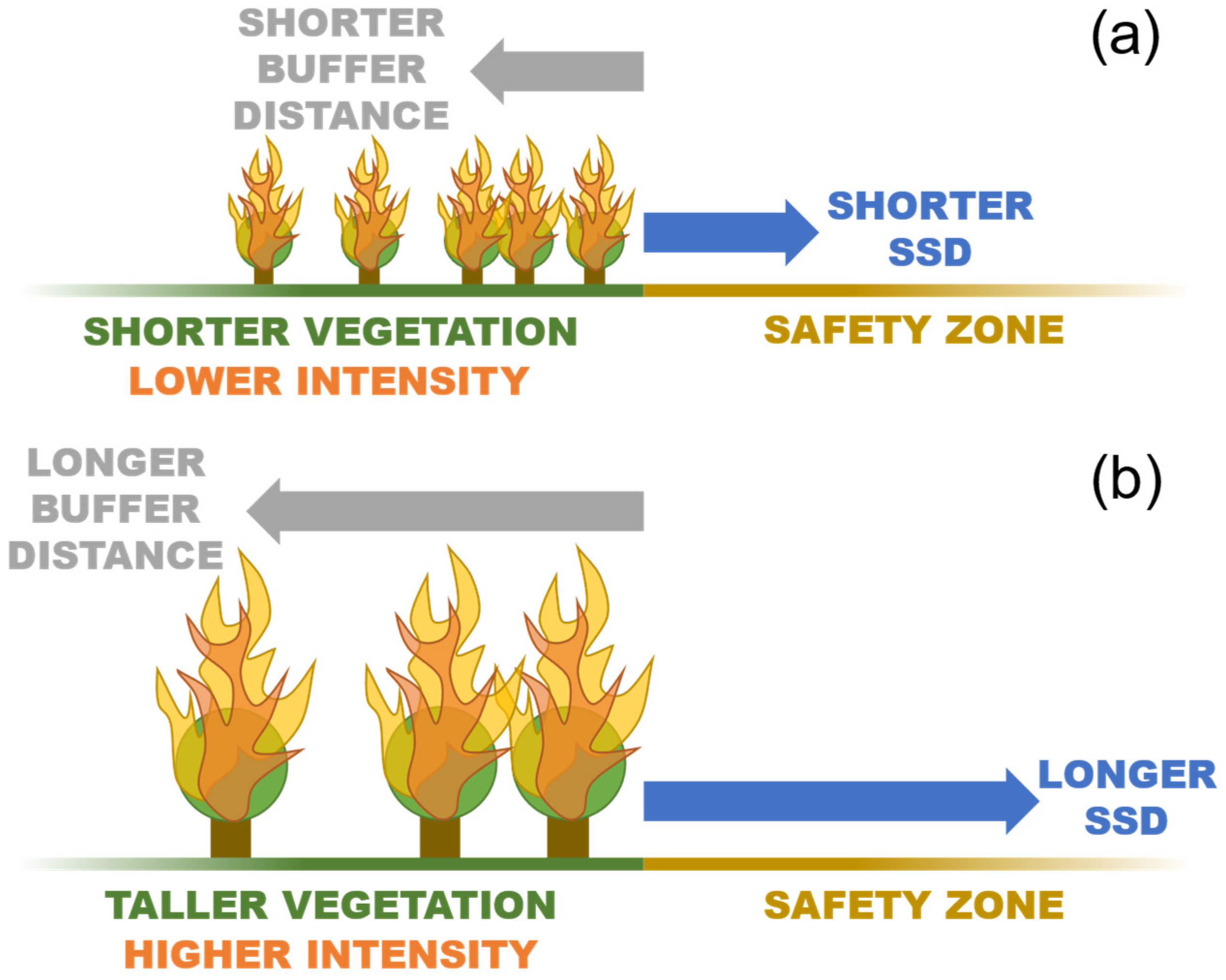
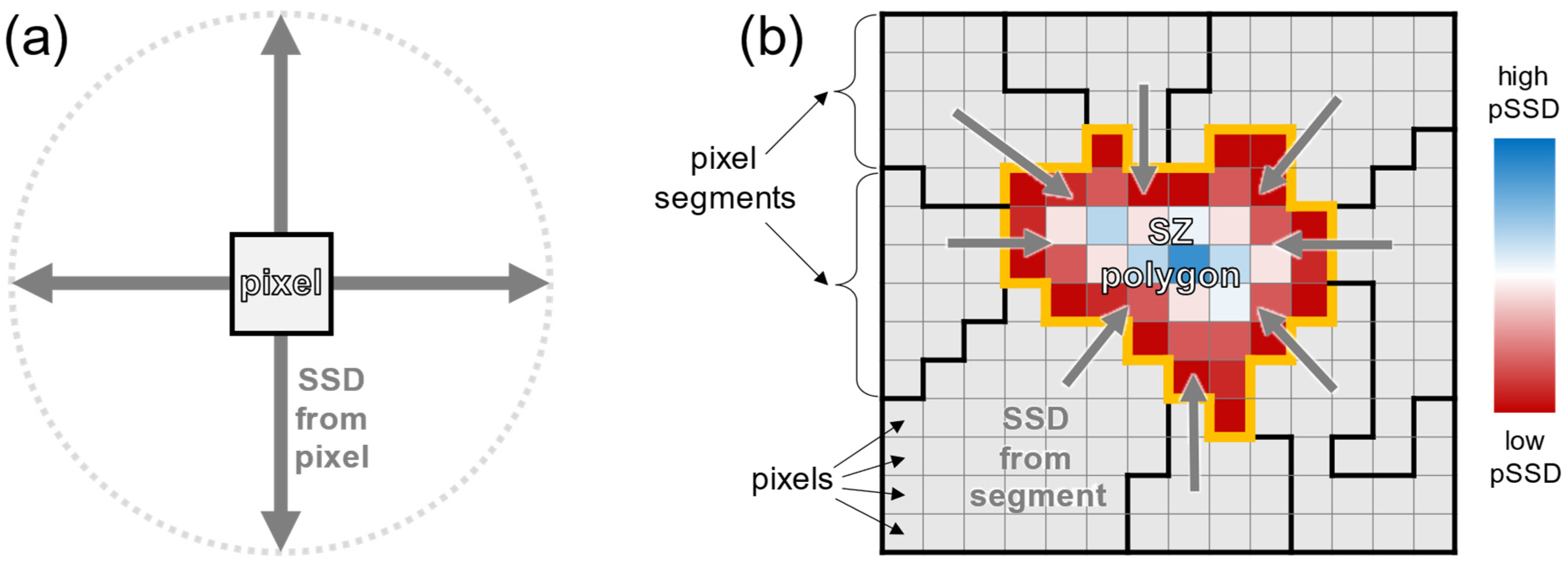
2.1. Algorithm Description
2.2. Vegetation Height Analysis
2.3. LANDFIRE Bias Correction
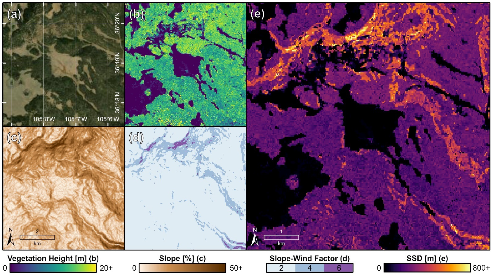
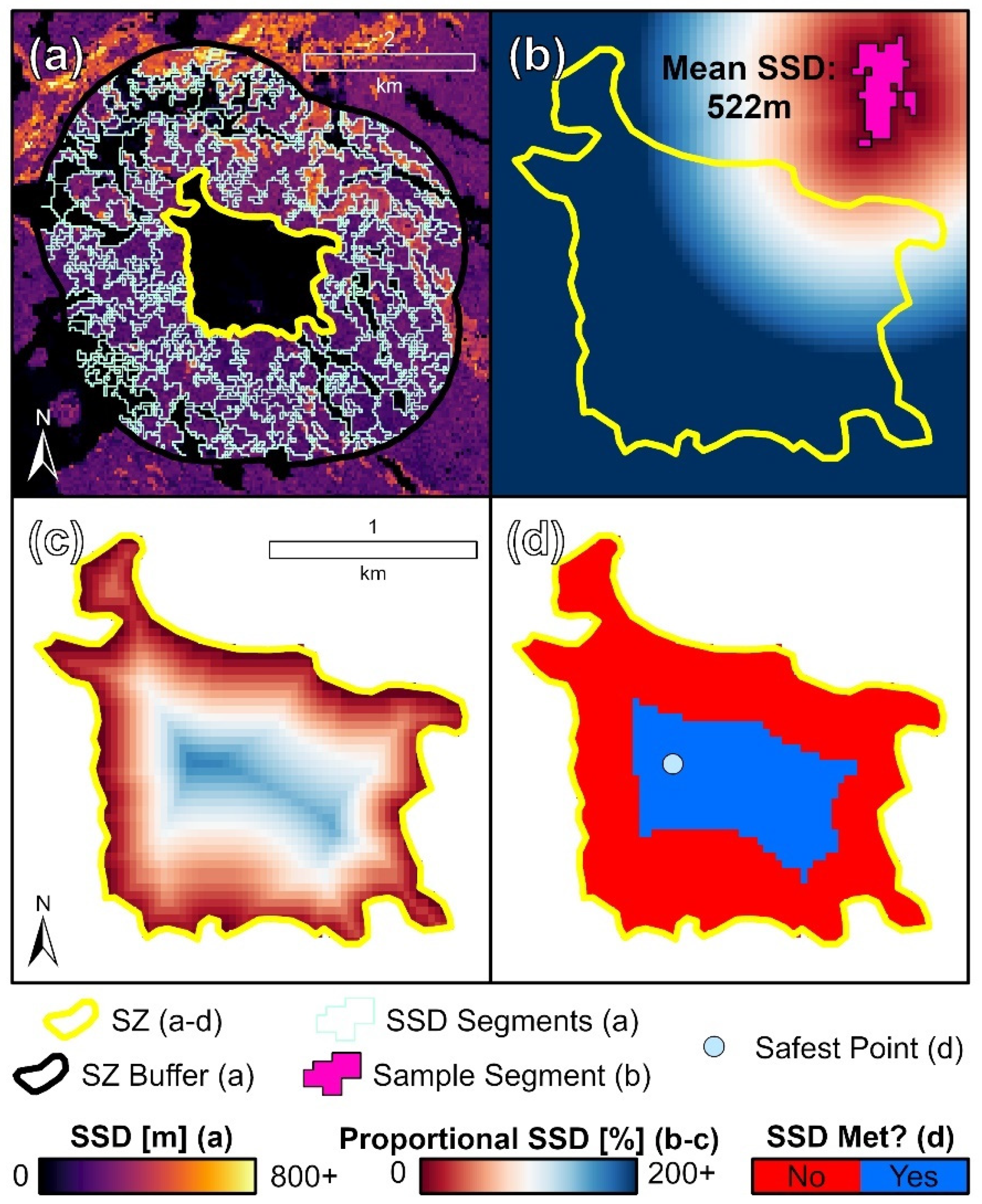
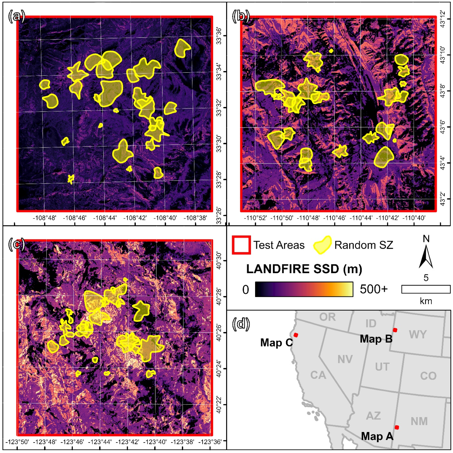
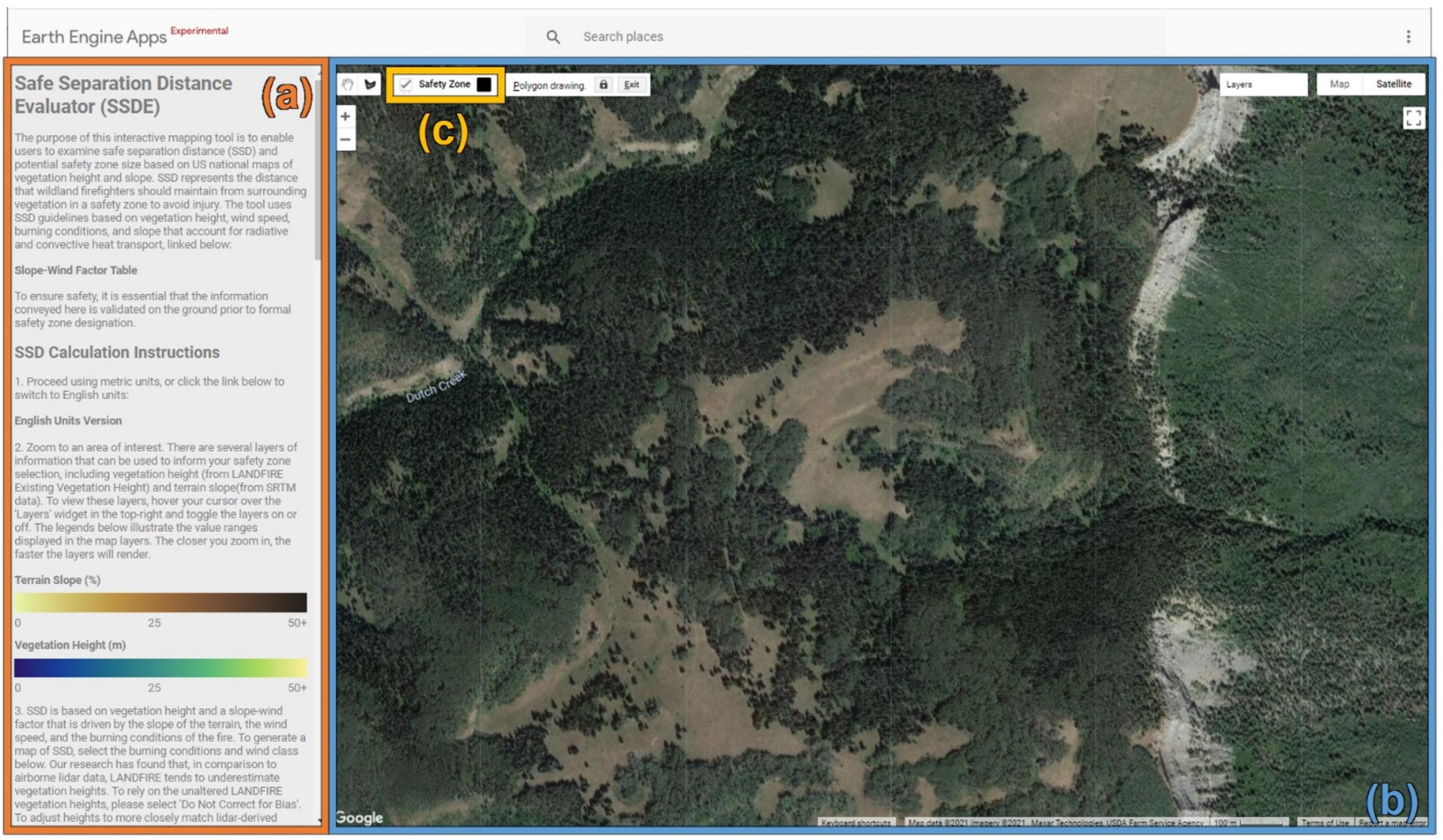
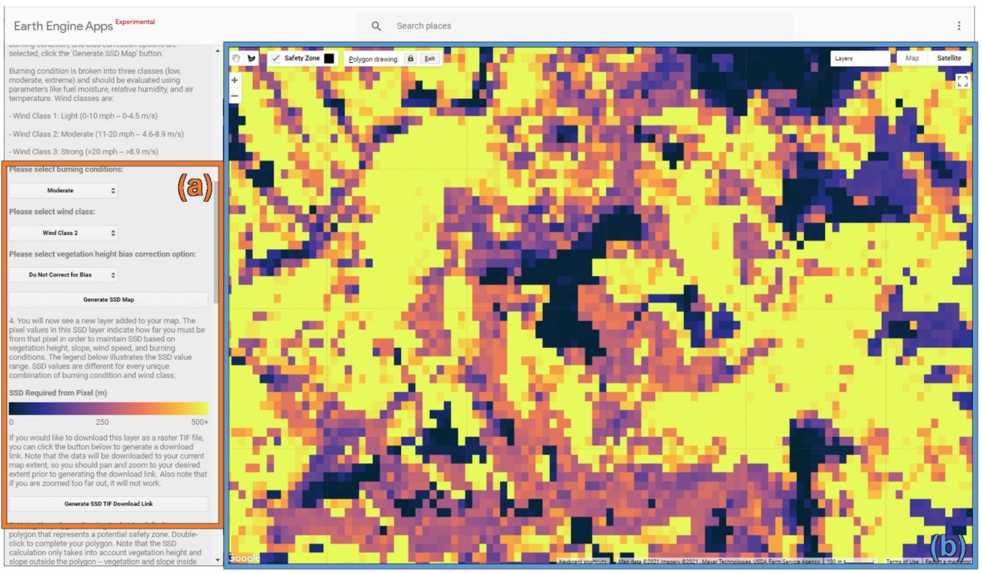
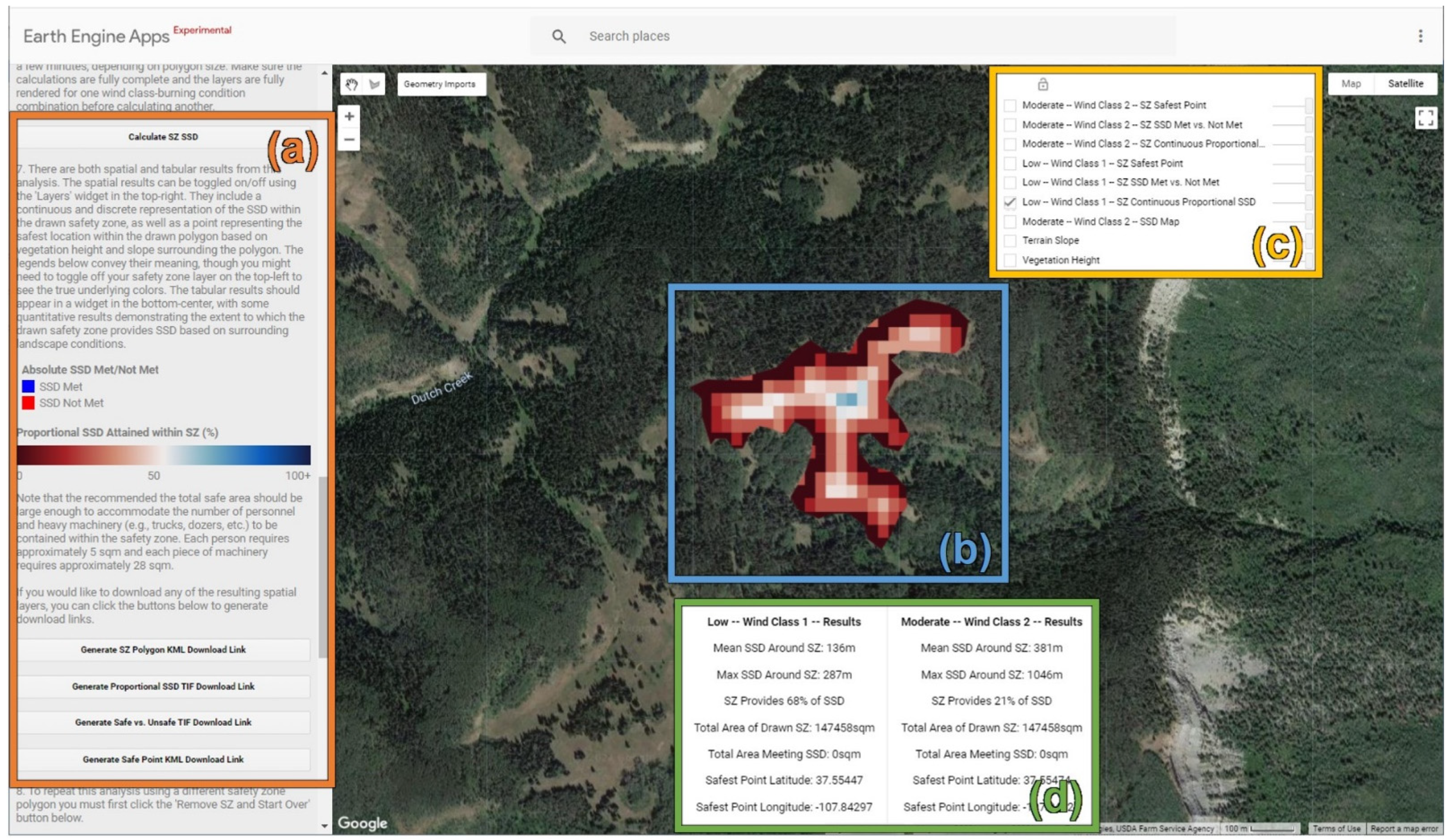
2.4. Use Case Demonstation
3. Results
3.1. GEE Application
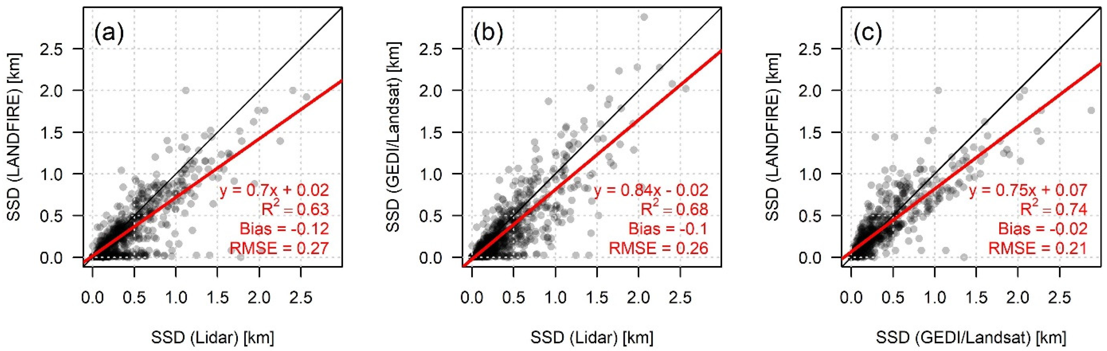
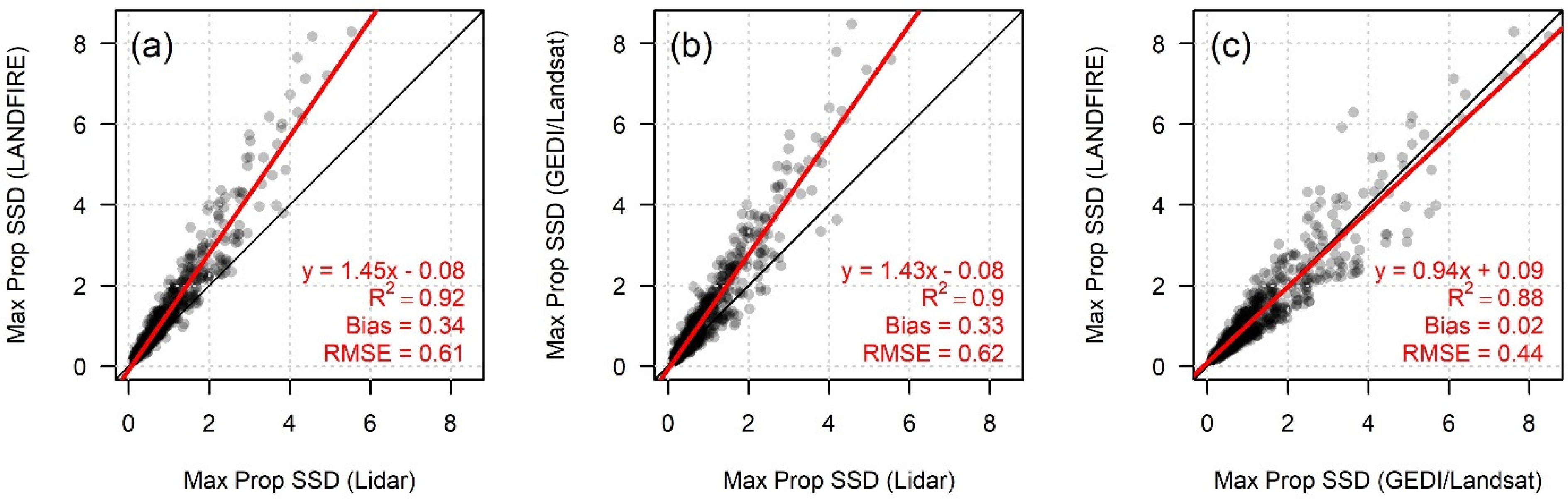
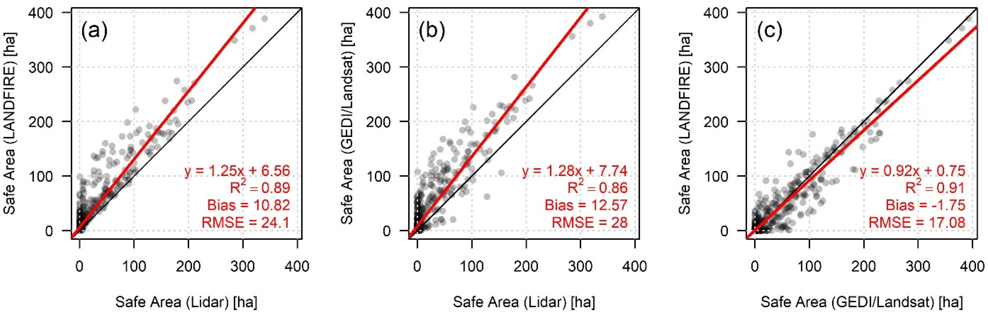
3.2. Vegetation Height Analysis
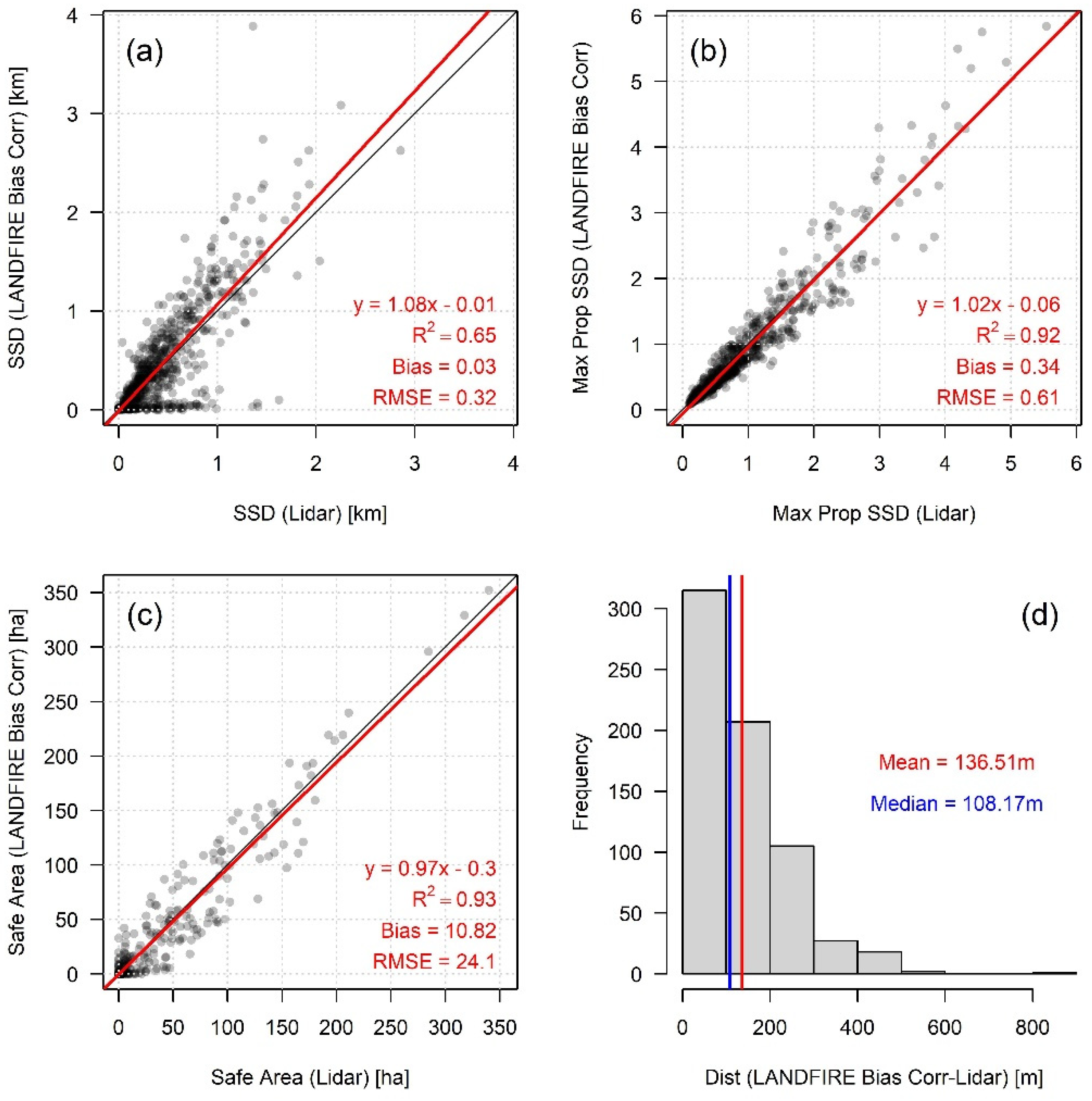
3.3. LANDFIRE Bias Correction
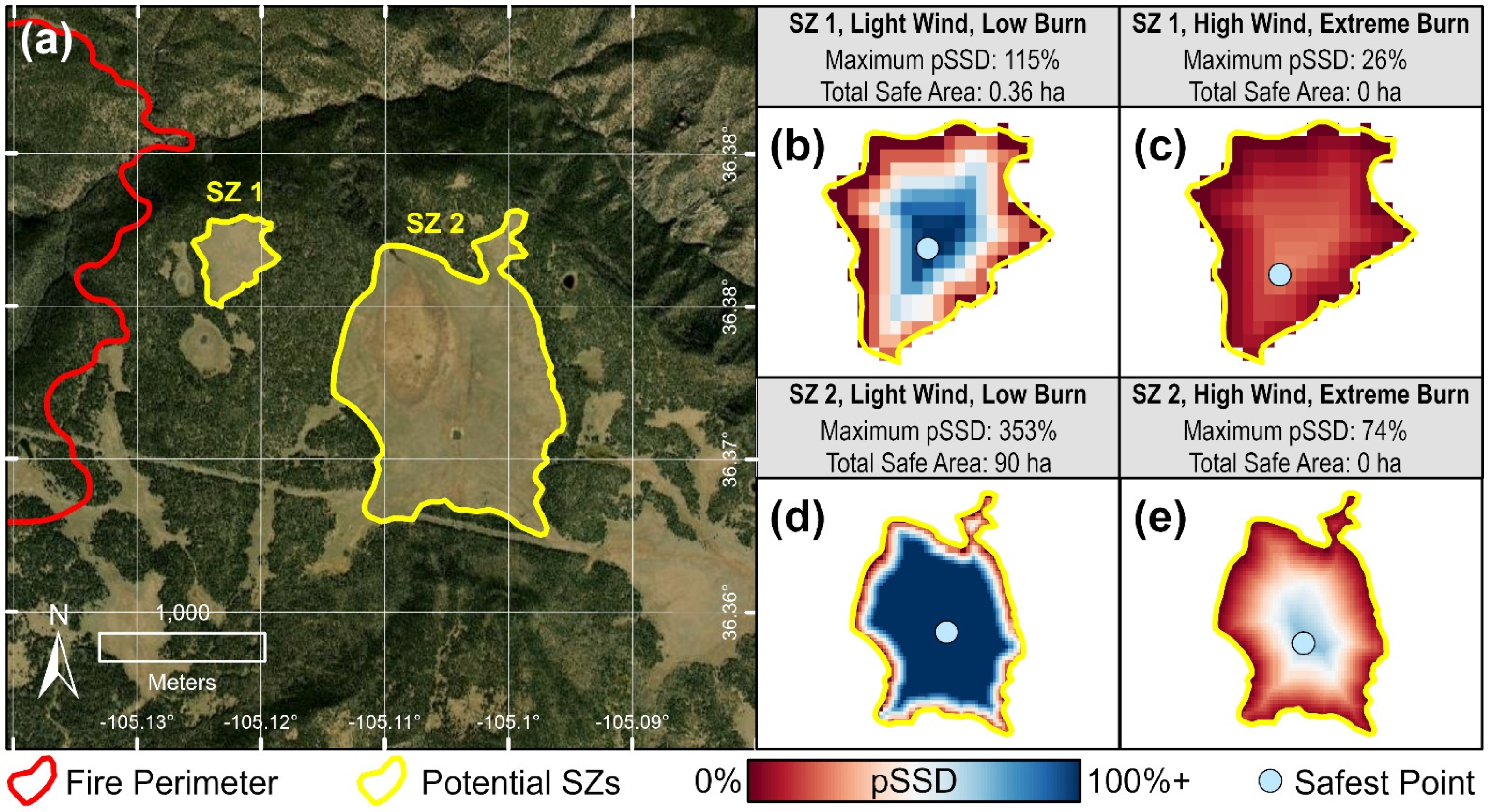
3.4. Use Case Demonstration
4. Discussion
5. Conclusions
Author Contributions
Funding
Data Availability Statement
Acknowledgments
Conflicts of Interest
Disclaimer
Appendix A

| Predictor | Data Type | Description |
|---|---|---|
| Vegetation Height | Continuous | Median vegetation height among pixels within buffer area around SZ polygon |
| Slope | Continuous | Median slope among pixels within buffer area around SZ polygon |
| Wind Speed | Categorical | Wind speed class from Table 1 |
| Burn Condition | Categorical | Burn condition class from Table 1 |
| SZ Polygon Area | Continuous | Total area of the SZ polygon |
| SZ Polygon Perimeter-to-Area Ratio | Continuous | Length of the SZ polygon perimeter divided by its area |
| SZ Polygon Elongation Ratio | Continuous | One minus the length of the shortest polygon axis divided by the length of the longest polygon axis |
| SZ Polygon Related Circumscribing Circle | Continuous | One minus the area of the polygon divided by the area of the smallest encompassing circle |
| SZ Polygon Shape Complexity Index | Continuous | One minus the area of the polygon divided by the area of a convex hull containing the polygon |
| Predictor | Rank | %IncMSE |
|---|---|---|
| Wind Speed | 1 | 95.3 |
| Slope | 2 | 40.6 |
| SZ Polygon Area | 3 | 31.0 |
| Vegetation Height | 4 | 27.9 |
| SZ Polygon Perimeter-to-Area Ratio | 5 | 25.9 |
| SZ Polygon Shape Complexity Index | 6 | 17.4 |
| SZ Polygon Elongation Ratio | 7 | 16.7 |
| SZ Polygon Related Circumscribing Circle | 8 | 16.7 |
| Burn Condition | 9 | 15.2 |
References
- Wei, Y.; Thompson, M.P.; Scott, J.H.; O’Connor, C.D.; Dunn, C.J. Designing Operationally Relevant Daily Large Fire Containment Strategies Using Risk Assessment Results. Forests 2019, 10, 311. [Google Scholar] [CrossRef]
- Silva, F.R.Y.; O’Connor, C.D.; Thompson, M.P.; Martínez, J.R.M.; Calkin, D.E. Modelling Suppression Difficulty: Current and Future Applications. Int. J. Wildland Fire 2020, 29, 739–751. [Google Scholar] [CrossRef]
- Connor, C.D.O.; Calkin, D.E.; Thompson, M.P. An Empirical Machine Learning Method for Predicting Potential Fire Control Locations for Pre-Fire Planning and Operational Fire Management. Int. J. Wildland Fire 2017, 26, 587–597. [Google Scholar] [CrossRef]
- Cheney, P.; Gould, J.; McCaw, L. The Dead-Man Zone—A Neglected Area of Firefighter Safety. Aust. For. 2001, 64, 45–50. [Google Scholar] [CrossRef]
- Page, W.G.; Butler, B.W. An Empirically Based Approach to Defining Wildland Firefighter Safety and Survival Zone Separation Distances. Int. J. Wildland Fire 2017, 26, 655–667. [Google Scholar] [CrossRef]
- Arizona State Forestry Division. Yarnell Hill Fire: Serious Accident Investigation Report. 2013. Available online: https://dffm.az.gov/sites/default/files/YHR_Data_092813_0.pdf (accessed on 3 January 2022).
- Butler, B.W.; Bartlette, R.A.; Bradshaw, L.S.; Cohen, J.D.; Andrews, P.L.; Putnam, T.; Mangan, R.J. Fire Behavior Associated with the 1994 South Canyon Fire on Storm King Mountain, Colorado; Research Paper RMRS-RP-9; U.S. Department of Agriculture, Forest Service, Rocky Mountain Research Station: Ogden, UT, USA, 1998; 82p. [CrossRef]
- Alexander, M.E.; Taylor, S.W.; Page, W.G. Wildland firefighter safety and fire behavior prediction on the fireline. In Proceedings of the 13th International Wildland Fire Safety Summit & 4th Human Dimensions Wildland Fire Conference, Boise, ID, USA, 20–24 April 2015; pp. 20–24. [Google Scholar]
- Butler, C.; Marsh, S.; Domitrovich, J.W.; Helmkamp, J. Wildland Firefighter Deaths in the United States: A Comparison of Existing Surveillance Systems. J. Occup. Environ. Hyg. 2017, 14, 258–270. [Google Scholar] [CrossRef] [PubMed]
- National Wildfire Coordinating Group Glossary A-Z|NWCG. Available online: https://www.nwcg.gov/glossary/a-z (accessed on 17 February 2017).
- Abatzoglou, J.T.; Williams, A.P. Impact of Anthropogenic Climate Change on Wildfire across Western US Forests. Proc. Natl. Acad. Sci. USA 2016, 113, 11770–11775. [Google Scholar] [CrossRef]
- Abatzoglou, J.T.; Battisti, D.S.; Williams, A.P.; Hansen, W.D.; Harvey, B.J.; Kolden, C.A. Projected Increases in Western US Forest Fire despite Growing Fuel Constraints. Commun. Earth Environ. 2021, 2, 227. [Google Scholar] [CrossRef]
- Dennison, P.E.; Brewer, S.C.; Arnold, J.D.; Moritz, M.A. Large Wildfire Trends in the Western United States, 1984–2011. Geophys. Res. Lett. 2014, 41, 2928–2933. [Google Scholar] [CrossRef]
- Balch, J.K.; Bradley, B.A.; Abatzoglou, J.T.; Nagy, R.C.; Fusco, E.J.; Mahood, A.L. Human-Started Wildfires Expand the Fire Niche across the United States. Proc. Natl. Acad. Sci. USA 2017, 114, 2946–2951. [Google Scholar] [CrossRef]
- Westerling, A.L. Increasing Western US Forest Wildfire Activity: Sensitivity to Changes in the Timing of Spring. Phil. Trans. R. Soc. B 2016, 371, 20150178. [Google Scholar] [CrossRef]
- Morse, G.A. A Trend Analysis of Fireline “Watch Out” Situations in Seven Fire-Suppression Fatality Accidents. Fire Manag. 2004, 66, 66–69. [Google Scholar]
- Ziegler, J.A. The Story Behind an Organizational List: A Genealogy of Wildland Firefighters’ 10 Standard Fire Orders. Commun. Monogr. 2007, 74, 415–442. [Google Scholar] [CrossRef]
- Gleason, P. Lookouts, Communications, Escape Routes, and Safety Zones. Available online: https://www.fireleadership.gov/toolbox/documents/lces_gleason.html (accessed on 17 February 2017).
- Thorburn, R.W.; Alexander, M.E. LACES versus LCES: Adopting an “A” for “Anchor Points” to improve wildland firefighter safety. In Proceedings of the 2001 International Wildland Fire Safety Summit, Missoula, MT, USA, 6–8 November 2001. [Google Scholar]
- Campbell, M.J.; Dennison, P.E.; Butler, B.W. Safe Separation Distance Score: A New Metric for Evaluating Wildland Firefighter Safety Zones Using Lidar. Int. J. Geogr. Inf. Sci. 2017, 31, 1448–1466. [Google Scholar] [CrossRef]
- Butler, B.W. Wildland Firefighter Safety Zones: A Review of Past Science and Summary of Future Needs. Int. J. Wildland Fire 2014, 23, 295–308. [Google Scholar] [CrossRef]
- Butler, B.W.; Cohen, J.D. Firefighter Safety Zones: A Theoretical Model Based on Radiative Heating. Int. J. Wildland Fire 1998, 8, 73–77. [Google Scholar] [CrossRef]
- National Wildfire Coordinating Group. Incident Response Pocket Guide. 2014. Available online: https://www.nwcg.gov/sites/default/files/publications/pms461.pdf (accessed on 3 January 2022).
- Dupuy, J.-L.; Maréchal, J. Slope Effect on Laboratory Fire Spread: Contribution of Radiation and Convection to Fuel Bed Preheating. Int. J. Wildland Fire 2011, 20, 289–307. [Google Scholar] [CrossRef]
- Frankman, D.; Webb, B.W.; Butler, B.W.; Jimenez, D.; Forthofer, J.M.; Sopko, P.; Shannon, K.S.; Hiers, J.K.; Ottmar, R.D. Measurements of Convective and Radiative Heating in Wildland Fires. Int. J. Wildland Fire 2013, 22, 157–167. [Google Scholar] [CrossRef]
- Parsons, R.; Butler, B.; Mell, W. “Ruddy” Safety Zones and Convective Heat: Numerical Simulation of Potential Burn Injury from Heat Sources Influenced by Slopes and Winds; Imprensa da Universidade de Coimbra: Coimbra, Portugal, 2014; ISBN 978-989-26-0884-6. [Google Scholar]
- Page, W.G.; Butler, B.W. Fuel and Topographic Influences on Wildland Firefighter Burnover Fatalities in Southern California. Int. J. Wildland Fire 2018, 27, 141–154. [Google Scholar] [CrossRef]
- Firefighter Safety|Missoula Fire Sciences Laboratory. Available online: https://www.firelab.org/project/firefighter-safety (accessed on 26 October 2021).
- Gorelick, N.; Hancher, M.; Dixon, M.; Ilyushchenko, S.; Thau, D.; Moore, R. Google Earth Engine: Planetary-Scale Geospatial Analysis for Everyone. Remote Sens. Environ. 2017, 202, 18–27. [Google Scholar] [CrossRef]
- Rollins, M.G. LANDFIRE: A Nationally Consistent Vegetation, Wildland Fire, and Fuel Assessment. Int. J. Wildland Fire 2009, 18, 235–249. [Google Scholar] [CrossRef]
- LANDFIRE LANDFIRE Remap 2016 Existing Vegetation Height (EVH) CONUS. Available online: https://landfire.cr.usgs.gov/distmeta/servlet/gov.usgs.edc.MetaBuilder?TYPE=HTML&DATASET=FE3 (accessed on 2 November 2021).
- Farr, T.G.; Rosen, P.A.; Caro, E.; Crippen, R.; Duren, R.; Hensley, S.; Kobrick, M.; Paller, M.; Rodriguez, E.; Roth, L.; et al. The Shuttle Radar Topography Mission. Rev. Geophys. 2007, 45, 25–36. [Google Scholar] [CrossRef]
- Dennison, P.E.; Fryer, G.K.; Cova, T.J. Identification of Firefighter Safety Zones Using Lidar. Environ. Model. Softw. 2014, 59, 91–97. [Google Scholar] [CrossRef]
- Andrews, P.L. Current Status and Future Needs of the BehavePlus Fire Modeling System. Int. J. Wildland Fire 2014, 23, 21–33. [Google Scholar] [CrossRef]
- Hopkinson, C.; Chasmer, L.; Lim, K.; Treitz, P.; Creed, I. Towards a Universal Lidar Canopy Height Indicator. Can. J. Remote Sens. 2006, 32, 139–152. [Google Scholar] [CrossRef]
- Peterson, B.; Nelson, K.J.; Seielstad, C.; Stoker, J.; Jolly, W.M.; Parsons, R. Automated Integration of Lidar into the LANDFIRE Product Suite. Remote Sens. Lett. 2015, 6, 247–256. [Google Scholar] [CrossRef]
- Potapov, P.; Li, X.; Hernandez-Serna, A.; Tyukavina, A.; Hansen, M.C.; Kommareddy, A.; Pickens, A.; Turubanova, S.; Tang, H.; Silva, C.E.; et al. Mapping Global Forest Canopy Height through Integration of GEDI and Landsat Data. Remote Sens. Environ. 2021, 253, 112165. [Google Scholar] [CrossRef]
- Dubayah, R.; Blair, J.B.; Goetz, S.; Fatoyinbo, L.; Hansen, M.; Healey, S.; Hofton, M.; Hurtt, G.; Kellner, J.; Luthcke, S.; et al. The Global Ecosystem Dynamics Investigation: High-Resolution Laser Ranging of the Earth’s Forests and Topography. Sci. Remote Sens. 2020, 1, 100002. [Google Scholar] [CrossRef]
- Sugarbaker, L.J.; Constance, E.W.; Heidemann, H.K.; Jason, A.L.; Lukas, V.; Saghy, D.L.; Stoker, J.M. The 3D Elevation Program. Initiative: A Call for Action; U.S. Geological Survey: Reston, VA, USA, 2014; p. 48.
- Isenburg, M. LAStools; Rapidlasso GmbH: Gilching, Germany, 2015. [Google Scholar]
- Yang, Y.; Xu, Z.; Wu, Y.; Wei, W.; Song, R. Virtual Fire Evacuation Drills through a Web-Based Serious Game. Appl. Sci. 2021, 11, 11284. [Google Scholar] [CrossRef]
- Keil, J.; Edler, D.; Schmitt, T.; Dickmann, F. Creating Immersive Virtual Environments Based on Open Geospatial Data and Game Engines. KN J. Cartogr. Geogr. Inf. 2021, 71, 53–65. [Google Scholar] [CrossRef]
- Kersten, T.; Drenkhan, D.; Deggim, S. Virtual Reality Application of the Fortress Al Zubarah in Qatar Including Performance Analysis of Real-Time Visualisation. KN J. Cartogr. Geogr. Inf. 2021, 71, 241–251. [Google Scholar] [CrossRef]
- Szabó, G.; Singh, S.K.; Szabó, S. Slope Angle and Aspect as Influencing Factors on the Accuracy of the SRTM and the ASTER GDEM Databases. Phys. Chem. Earth Parts A/B/C 2015, 83, 137–145. [Google Scholar] [CrossRef]
- Gorokhovich, Y.; Voustianiouk, A. Accuracy Assessment of the Processed SRTM-Based Elevation Data by CGIAR Using Field Data from USA and Thailand and Its Relation to the Terrain Characteristics. Remote Sens. Environ. 2006, 104, 409–415. [Google Scholar] [CrossRef]
- Gesch, D.B.; Oimoen, M.J.; Evans, G.A. Accuracy Assessment of the US Geological Survey National Elevation Dataset, and Comparison with Other Large-Area Elevation Datasets: SRTM and ASTER; US Department of the Interior, US Geological Survey: Reston, VA, USA, 2014; Volume 1008.
- Campbell, M.J.; Dennison, P.E.; Butler, B.W.; Page, W.G. Using Crowdsourced Fitness Tracker Data to Model the Relationship between Slope and Travel Rates. Appl. Geogr. 2019, 106, 93–107. [Google Scholar] [CrossRef]
- Sullivan, P.R.; Campbell, M.J.; Dennison, P.E.; Brewer, S.C.; Butler, B.W. Modeling Wildland Firefighter Travel Rates by Terrain Slope: Results from GPS-Tracking of Type 1 Crew Movement. Fire 2020, 3, 52. [Google Scholar] [CrossRef]
- Campbell, M.J.; Dennison, P.E.; Butler, B.W. A LiDAR-Based Analysis of the Effects of Slope, Vegetation Density, and Ground Surface Roughness on Travel Rates for Wildland Firefighter Escape Route Mapping. Int. J. Wildland Fire 2017, 26, 884–895. [Google Scholar] [CrossRef]
- Campbell, M.J.; Page, W.G.; Dennison, P.E.; Butler, B.W. Escape Route Index: A Spatially-Explicit Measure of Wildland Firefighter Egress Capacity. Fire 2019, 2, 40. [Google Scholar] [CrossRef]
- Fryer, G.K.; Dennison, P.E.; Cova, T.J. Wildland Firefighter Entrapment Avoidance: Modelling Evacuation Triggers. Int. J. Wildland Fire 2013, 22, 883–893. [Google Scholar] [CrossRef]
- Dunn, C.J.; O’Connor, C.D.; Reilly, M.J.; Calkin, D.E.; Thompson, M.P. Spatial and Temporal Assessment of Responder Exposure to Snag Hazards in Post-Fire Environments. For. Ecol. Manag. 2019, 441, 202–214. [Google Scholar] [CrossRef]
- Silva, F.R.Y.; Martínez, J.R.M.; González-Cabán, A. A Methodology for Determining Operational Priorities for Prevention and Suppression of Wildland Fires. Int. J. Wildland Fire 2014, 23, 544–554. [Google Scholar] [CrossRef]
- Dunn, C.J.; O’Connor, C.D.; Abrams, J.; Thompson, M.P.; Calkin, D.E.; Johnston, J.D.; Stratton, R.; Gilbertson-Day, J. Wildfire Risk Science Facilitates Adaptation of Fire-Prone Social-Ecological Systems to the New Fire Reality. Environ. Res. Lett. 2020, 15, 25001. [Google Scholar] [CrossRef]
- Thompson, M.P.; Bowden, P.; Brough, A.; Scott, J.H.; Gilbertson-Day, J.; Taylor, A.; Anderson, J.; Haas, J.R. Application of Wildfire Risk Assessment Results to Wildfire Response Planning in the Southern Sierra Nevada, California, USA. Forests 2016, 7, 64. [Google Scholar] [CrossRef]
- Thompson, M.P.; Gannon, B.M.; Caggiano, M.D.; O’Connor, C.D.; Brough, A.; Gilbertson-Day, J.W.; Scott, J.H. Prototyping a Geospatial Atlas for Wildfire Planning and Management. Forests 2020, 11, 909. [Google Scholar] [CrossRef]
- Calkin, D.E.; O’Connor, C.D.; Thompson, M.P.; Stratton, R. Strategic Wildfire Response Decision Support and the Risk Management Assistance Program. Forests 2021, 12, 1407. [Google Scholar] [CrossRef]
- Breiman, L. Random Forests. Mach. Learn. 2001, 45, 5–32. [Google Scholar] [CrossRef]
- Cutler, F.; Cutler, A.; Liaw, A.; Wiener, M. RandomForest: Breiman and Cutler’s Random Forests for Classification and Regression. 2018. Available online: https://cran.r-project.org/web/packages/randomForest/index.html (accessed on 3 January 2022).
- R Core Team. R: A Language and Environment for Statistical Computing; R Foundation for Statistical Computing: Vienna, Austria, 2018. [Google Scholar]
- John Lindsay Patch Shape Tools—WhiteboxTools User Manual. Available online: https://www.whiteboxgeo.com/manual/wbt_book/available_tools/gis_analysis_patch_shape_tools.html (accessed on 11 November 2021).


| Slope | |||||||
|---|---|---|---|---|---|---|---|
| Flat (0–7.5%) | Low (7.6–22.5%) | Moderate (22.6–40%) | Steep (>40%) | ||||
| Wind Speed | Light (0–4.5 m/s) | 0.8 | 1 | 1 | 2 | Low | Burning Condition |
| 1 | 1 | 1.5 | 2 | Moderate | |||
| 1 | 1.5 | 1.5 | 3 | Extreme | |||
| Moderate (4.6–8.9 m/s) | 1.5 | 2 | 3 | 4 | Low | ||
| 2 | 2 | 4 | 6 | Moderate | |||
| 2 | 2.5 | 5 | 6 | Extreme | |||
| High (>8.9 m/s) | 2.5 | 3 | 4 | 6 | Low | ||
| 3 | 3 | 5 | 7 | Moderate | |||
| 3 | 4 | 5 | 10 | Extreme | |||
Publisher’s Note: MDPI stays neutral with regard to jurisdictional claims in published maps and institutional affiliations. |
© 2022 by the authors. Licensee MDPI, Basel, Switzerland. This article is an open access article distributed under the terms and conditions of the Creative Commons Attribution (CC BY) license (https://creativecommons.org/licenses/by/4.0/).
Share and Cite
Campbell, M.J.; Dennison, P.E.; Thompson, M.P.; Butler, B.W. Assessing Potential Safety Zone Suitability Using a New Online Mapping Tool. Fire 2022, 5, 5. https://doi.org/10.3390/fire5010005
Campbell MJ, Dennison PE, Thompson MP, Butler BW. Assessing Potential Safety Zone Suitability Using a New Online Mapping Tool. Fire. 2022; 5(1):5. https://doi.org/10.3390/fire5010005
Chicago/Turabian StyleCampbell, Michael J., Philip E. Dennison, Matthew P. Thompson, and Bret W. Butler. 2022. "Assessing Potential Safety Zone Suitability Using a New Online Mapping Tool" Fire 5, no. 1: 5. https://doi.org/10.3390/fire5010005
APA StyleCampbell, M. J., Dennison, P. E., Thompson, M. P., & Butler, B. W. (2022). Assessing Potential Safety Zone Suitability Using a New Online Mapping Tool. Fire, 5(1), 5. https://doi.org/10.3390/fire5010005