Article

Climate Change, Fire and Human Activity Drive Vegetation Change during the Last Eight Millennia in the Xistral Mountains of NW Iberia

by
Tim M. Mighall
1,*,
Antonio Martínez Cortizas
2,3,
Noemí Silva-Sánchez
4,
Olalla López-Costas
5,6 and
Lourdes López-Merino
7
1
Geography & Environment, School of Geosciences, University of Aberdeen, Aberdeen AB25 3UF, UK
2
CRETUS, EcoPast (GI-1553), Facultade de Bioloxía, Campus Sur, Universidade de Santiago de Compostela, E-15782 Santiago de Compostela, Spain
3
Bolin Centre for Climate Research, Stockholm University, SE-10691 Stockholm, Sweden
4
Instituto de Ciencias del Patrimonio, Consejo Superior de Investigaciones Científicas (INCIPIT-CSIC), E-15702 Santiago de Compostela, Spain
5
CRETUS; EcoPast (GI-1553), Area of Archaeology, Department of History, Facultade de Xeografía e Historia, Universidade de Santiago de Compostela, E-15782 Santiago de Compostela, Spain
6
Archaeological Research Laboratory, Wallenberg Laboratoriet, Stockholm University, SE-10691 Stockholm, Sweden
7
ENVIROVEG (grupo UCM 910164), Unidad de Botánica, Facultad de Farmacia, Universidad Complutense de Madrid, 28040 Madrid, Spain
*
Author to whom correspondence should be addressed.
Quaternary 2023, 6(1), 5; https://doi.org/10.3390/quat6010005
Submission received: 26 October 2022 / Revised: 1 December 2022 / Accepted: 5 December 2022 / Published: 5 January 2023
(This article belongs to the Special Issue Climate Change and Vegetation Evolution during the Holocene)

Abstract

:
An 8500-year record of high-resolution pollen, non-pollen palynomorph, microscopic charcoal and selected geochemical data (Ti, Zr and Pb) is presented from an ombrotrophic mire from the Xistral Mountains, Galicia, North-West Iberia. The results suggest that vegetation changes over the last eight millennia are primarily the result of human disturbance, fire and climate change. Climate and fire were the main factors influencing vegetation development during the early to mid-Holocene, including a short-lived decline in forest cover c. 8.2 cal. ka BP. Changes associated with the 4.2 and 2.8 cal. Ka BP events are less well defined. Human impact on vegetation became more pronounced by the late Holocene with major periods of forest disturbance from c. 3.1 cal. ka BP onwards: during the end of Metal Ages, Roman period and culminating in the permanent decline of deciduous forests in the post-Roman period, as agriculture and metallurgy intensified, leading to the creation of a cultural landscape. Climate change appears to become less influential as human activity dominates during the Late Holocene.

1. Introduction

There has been much debate with regard to how global climate events have influenced vegetation and cultural change during the Holocene [1,2,3,4,5,6,7,8,9]. Notwithstanding various issues of comparing proxy data with the archaeological and historical record [10], many notable climate changes appear to coincide with major archaeological transitions, cultural development, changes in settlement and land use [11,12,13,14], societal disruption [15,16] and plagues [17]. A close connection between climate change and vegetational response has also been suggested [18,19] and although recent research has tried to determine the respective roles climate and human activity played in shaping the evolution of vegetation and the landscape during the Holocene [20,21,22], it is still not fully resolved.
An often-cited criticism of many palaeoecological studies is that the data is of low resolution and lacks sufficient temporal resolution to identify climate changes at sub-millennial timescales [23] or there is insufficient proxy data to disentangle climatic drivers of change from human agencies unambiguously [24], with studies over-reliant on one proxy. Thus, many of the complexities involved are still poorly understood [8]. It can be difficult to establish causal relationships between cultural and environmental changes given the imprecise chronologies and the fragmentary nature of many of the palaeoecological records [25]. There is a need for further long-term vegetation studies to better understand the interaction and time lags between climate, vegetation change and humans in the Iberian Peninsula [25]. This paper partly addresses these issues by using a fine resolution, multi-proxy dataset to reconstruct vegetation, climate changes, soil erosion and fire histories during the Holocene from an ombrotrophic mire in the Xistral Mountains, Galicia, NW Spain. We use pollen, non-pollen palynomorphs (NPPs), microscopic charcoal, selected geochemical and peat humification data to examine the complex and multifaceted relationship between climate changes, human activity, fire and vegetation changes in the region during the last eight millennia.

2. Sites, Archaeological Context, and Methods

2.1. Site Characteristics and Sampling

The Pena da Cadela (PDC) ombrotrophic mire is situated in the Xistral Mountains in NW Spain at an elevation of 970 m and at 25 km south of the Atlantic coast (Figure 1). The PDC bog is a saddle mire of 0.5 ha, slightly domed at its centre, immersed in a large blanket macrotope that covers around 800 ha. The mean annual temperature is 7.5 °C and mean annual precipitation is approximately 1800 mm [26]. Present day mire vegetation is dominated by sedges (Carex durieui, C. vulgaris, C. panicea, Eleocharis multicaulis) and grasses (Agrostis curtisii, A. hesperica, Molinia caerulea, Deschampsia flexuosa). Heathers are also present (Erica mackaiana, E. cinerea) [27]. The ombrotrophic nature of this bog is corroborated by the low ash content, pH and bulk density, as well as other geochemical parameters [28].
A 4-metre-deep core, named PDC2, was extracted from the ombrotrophic mire in close proximity (within 50 m) to the original sampling site (PDC) [29]. It was sliced into 1 cm thick sections in the upper metre and into 2 cm slices from 1 metre depth to the base of the peat. The new sampling site was chosen to provide a longer temporal record and to collate more data at a finer resolution from additional proxies to help disentangle the respective roles of climate, fire, and human impact on vegetation throughout the Holocene. The aim of this paper is not to compare the two sites in detail, but the new data presented here replicates the main changes identified during the last five millennia recorded at site PDC.
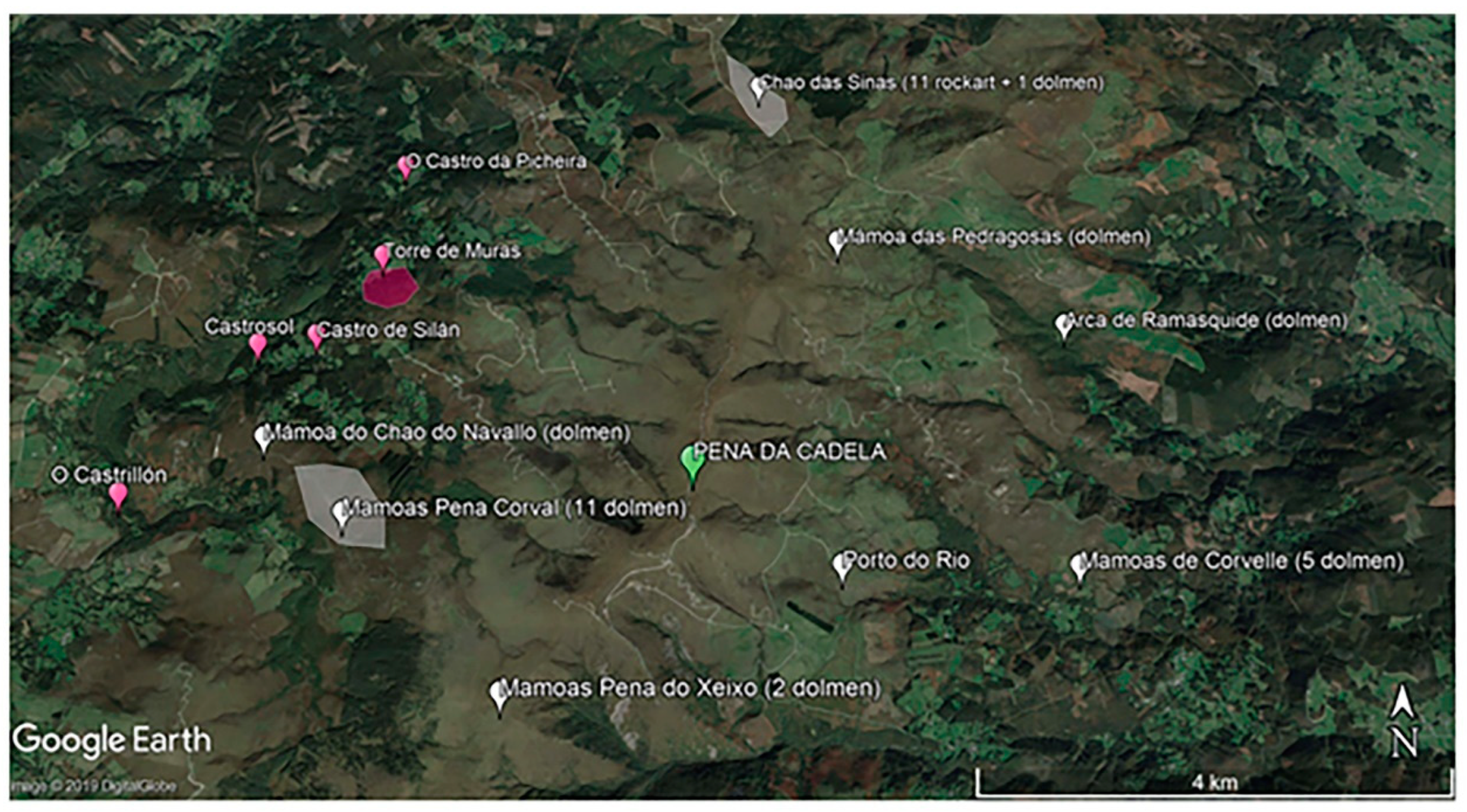
There are numerous archaeological sites relatively close to PDC including rock-shelters, caves and open-air sites [30,31,32]. Upper Palaeolithic layers occur at South in Pena Grande and Férvedes II, and Epipalaeolithic sites at Xestido III (8400–7800 cal. BP), Pena Vella, Chan da Cruz and the Rei Cintolo Cave (8600–8400 cal. BP) [30,31,32,33,34]. Megalithic mounds appeared in the 5th millennium BC and some were reused during the 3rd to 2nd millennium BC transition, but interest in these locations may extend back into the Mesolithic [35]. Some small megalithic funerary monuments have been found relatively close to PDC, including Pena do Seixo “mámoas” (2 mounds; located 2.4 km to the south) and Mamoas Pena Corval (11 mounds; 3 km to the west); both situated at 890 m and 700 m a.s.l., respectively. Two large funerary areas with 11 monuments in one of them (Mamoas Pena Corval; 3 km to the west) and 5 in the other (Mamoas de Corvelle; 3.4 km to the east), as well as an area with 11 rock-art panels (Chao das Sinas; 4.3 km to the North) are located within less than 5 km (Figure 1). They are attributed to this time period based on archaeological evidence, but there is no absolute dating. To our knowledge, there are at least five hillforts surrounding PDC mire to the west, the largest one known as Torre Mura. The occupancy of the hillforts, locally called “castros”, usually extended until the Roman period, and many of them have occupation layers up to the 2nd century AD or even the 3rd or 4thcenturies AD [36]. Therefore, it is difficult to distinguish between Iron- and Roman Age occupation without further excavations. Nevertheless, the proximity (4–4.5 km to PDC) and number of hillforts point to a high use of the space that certainly incorporated the study area.

2.2. Radiocarbon Chronology and Age-Depth Model

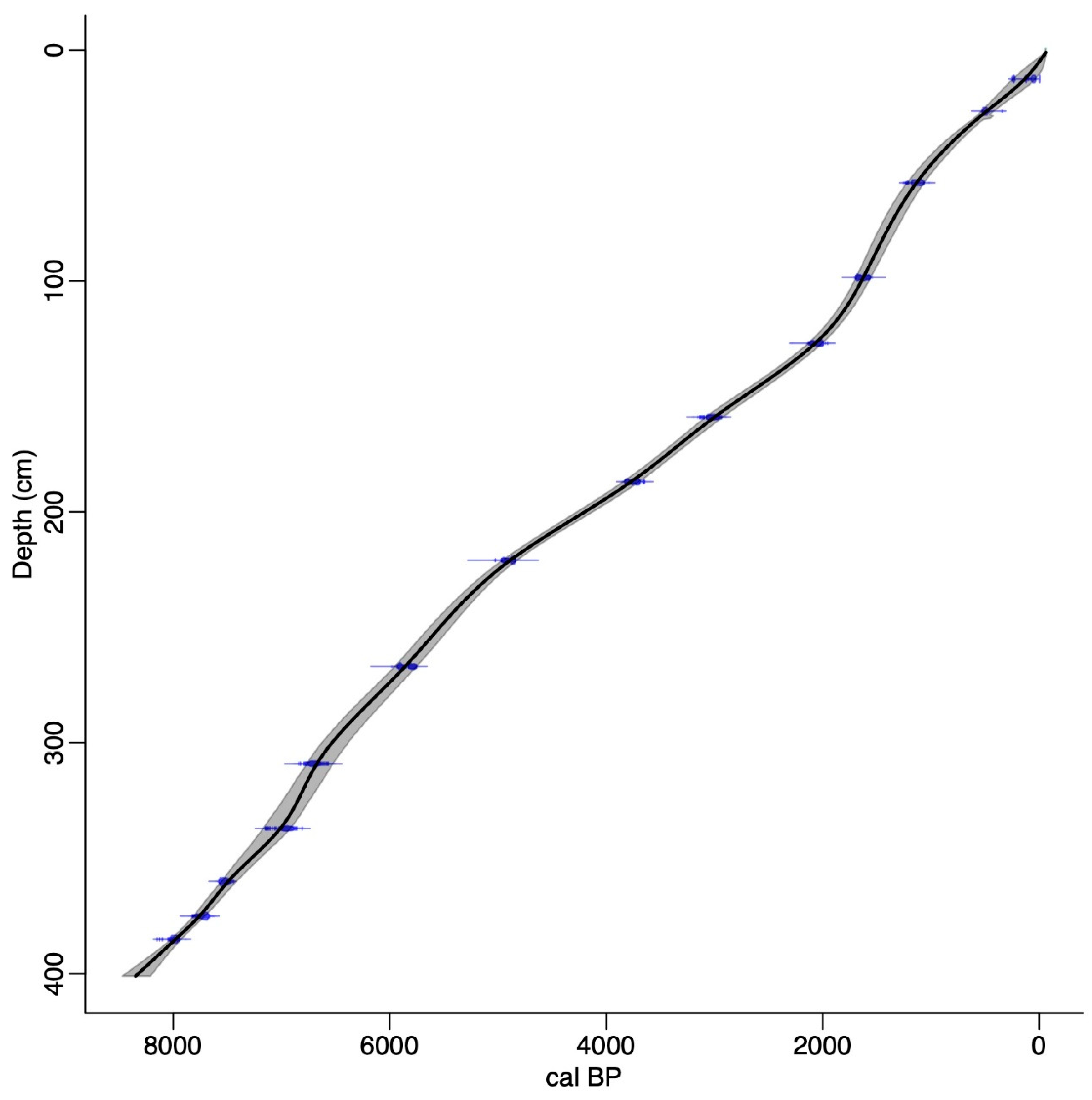
Fourteen bulk peat samples were sent to Beta Analytic Inc. (Miami, FL, USA) for radiocarbon dating. The age of the base of the core indicates that the peat has accumulated over the last 8500 calibrated years BP (Table 1). Ages were calibrated using CALIB 8.2 and IntCal20 northern hemispheric radiocarbon calibration curve [37]. An age-depth model for PDC2, constructed using CLAM [38], is shown in Figure 2. All dates mentioned in this paper are given as calibrated years BP and are rounded up/down to the nearest half decade.

2.3. Palynological Record

Palynological analyses were undertaken using standard techniques [39]. Sub-samples of 1 cm in diameter from each peat slice were prepared for palynological analysis using the procedure [40]. Pollen, NPPs and microscopic charcoal particles were extracted an counted at 1–2 cm intervals. At least 500 land pollen grains were counted for each sub-sample and for most layers at least 100 NPPs were also recorded. One Lycopodium clavatum tablet was added to each sub-sample [41]. Pollen identification was made using identification keys [39,42] and a reference collection housed in the School of Geosciences at the University of Aberdeen. Cereal-type pollen was differentiated from wild grass pollen based on grain size, pore and annulus diameter and surface sculpturing [43]. Pollen preservation was recorded [44] and damaged pollen grains were classified as broken, corroded, crumpled or degraded. Pollen grains that had no remaining distinguishing features were categorised as unidentified. As the separation of Myrica gale from Corylus avellana can be difficult, these pollen grain types are classified as Corylus avellana-type [45]. Basic land use designations interpreted from the pollen records are used [46]. NPPs were identified using the HdV system [47].
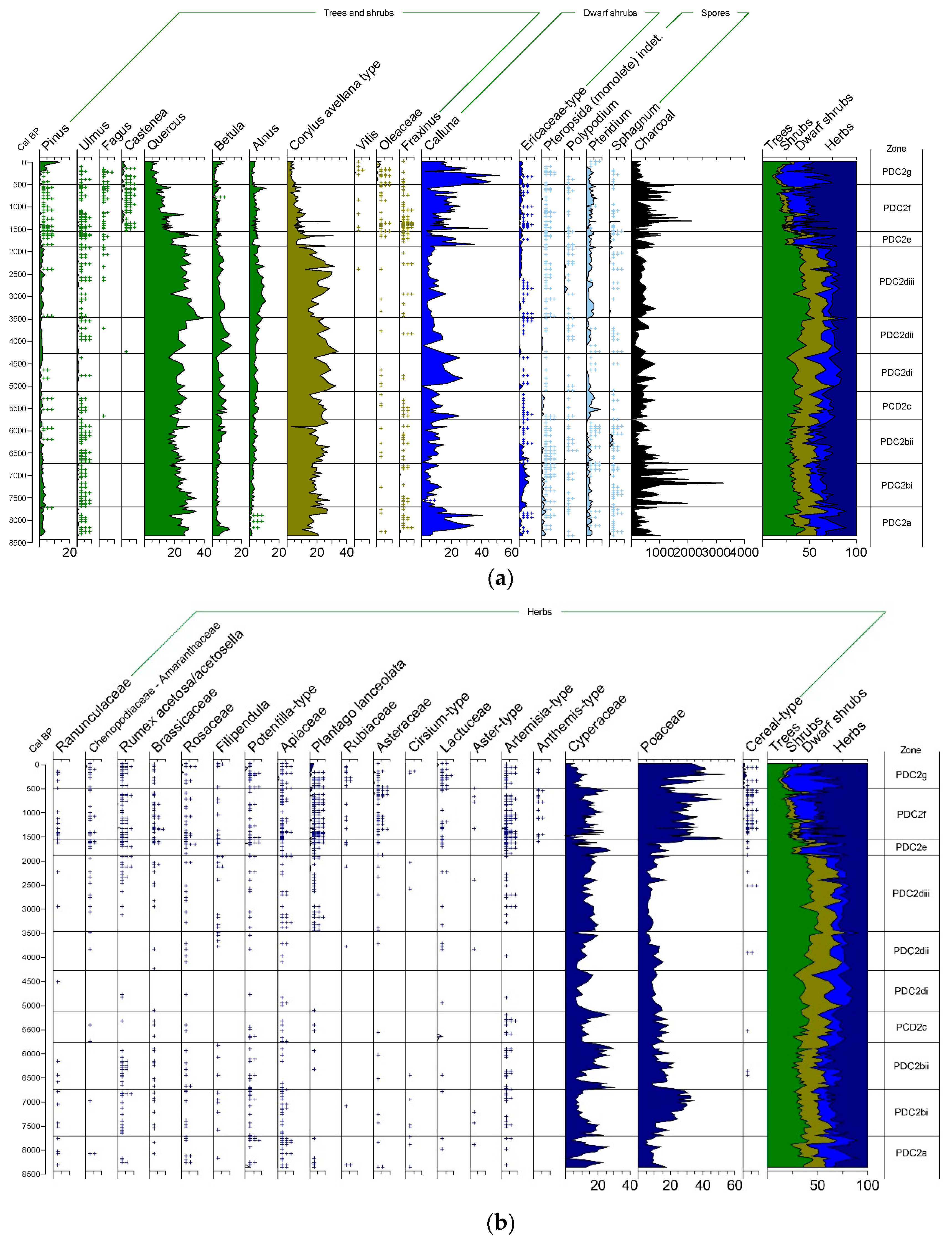
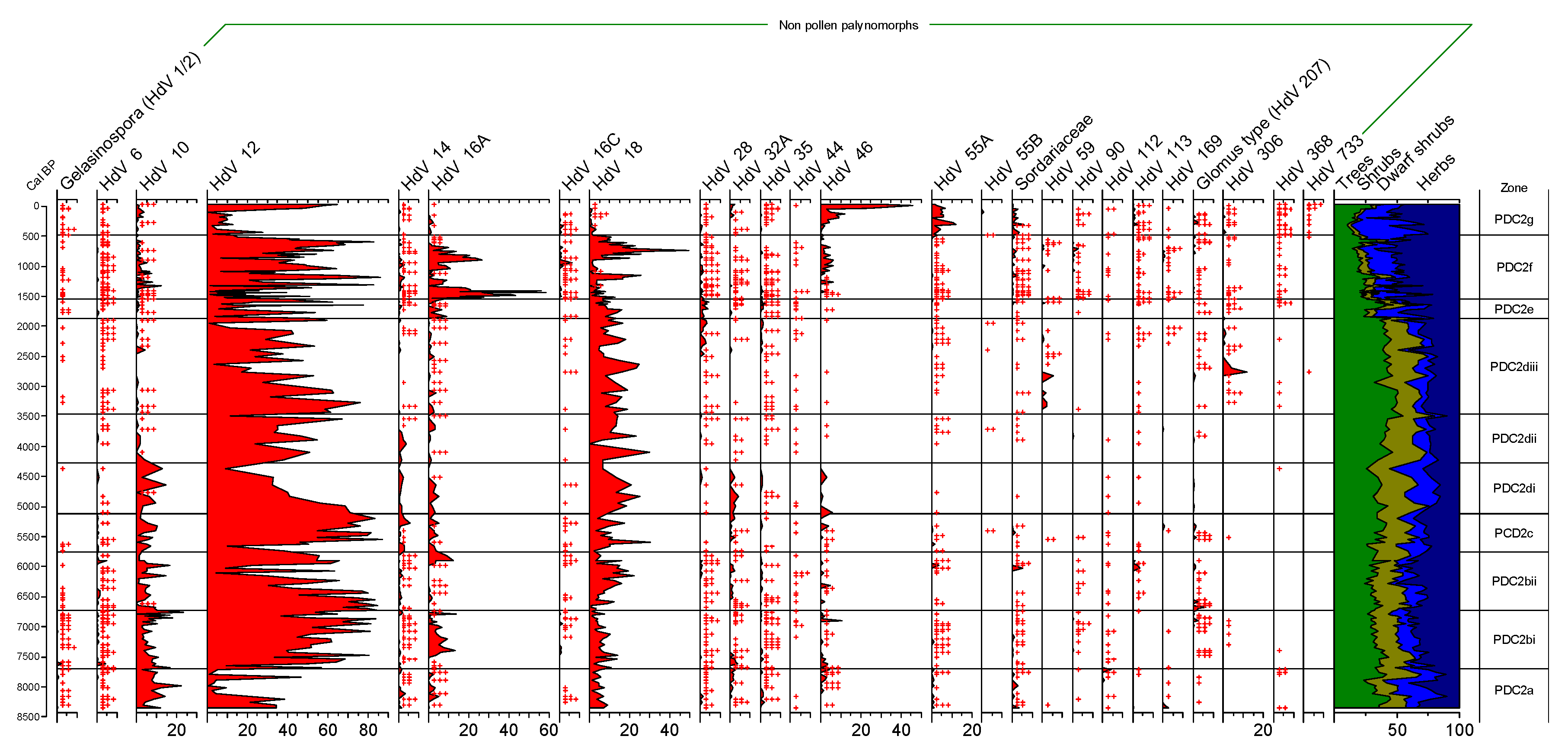
The pollen data are expressed as percentages of total land pollen (TLP), excluding spores and aquatics. Spores and aquatics are also expressed as percentages of TLP, whilst NPPs are expressed as the sum of total land pollen and NPP excluding HdV12. Due to its abundance HdV12 is expressed as a percentage of TLP and NPPs including HdV12. The pollen diagrams were constructed using Tilia and Tilia.graph [48]. Pollen nomenclature follows Stace (1991) [49]. Microscopic charcoal was recorded during palynological counting to at least 100 fragments (when possible), were split according to their size (0–21 µm, 21–50 µm and >50 µm) and expressed as a percentage of TLP. Percentages diagrams for selected pollen and NPPs are shown in Figure 3a,b and Figure 4. Complete diagrams are available in the Supplementary Information (Supplementary Material Figures S1a,b and S2).

2.4. Geochemistry

Selected chemical elements were analysed to trace soil dust deposition (Ti and Zr) and atmospheric metal pollution (Pb). Increases in dust can be related to soil erosion and storminess [50,51,52,53], while atmospheric metal pollution is related to mining and metallurgy [54,55]. Concentrations of these elements were determined using an X-ray fluorescence dispersive EMMA-XRF analyser [56], housed at the RIAIDT facility at the University of Santiago de Compostela. Calibration was done using standard reference materials and detection limits were 2 µg g−1 for Ti and 0.5 µg g−1 for Zr and Pb.

2.5. Peat Humification

The humic acid fraction of dried and milled peat samples was extracted using a solution of 8% NaOH. UV-transmission of the NaOH peat extracts was then measured at the University of Santiago de Compostela using a spectrophotometer set at a wavelength of 540 nm following the procedure outlined by Blackford and Chambers (1993) [57]. This index is usually interpreted as reflecting wet (low peat decomposition) and dry (high peat decomposition) conditions, although other factors, such as changes in vegetation, may also be involved [58,59,60]. It is also affected by the long-term increase in peat decomposition [61]. Thus, to capture shorter-term variations, we detrended the results from the long-term variation.

2.6. Numerical Methods

Principal Component Analysis (PCA) was performed to help to extract the regional landscape signals (using pollen types) to summarise common patterns of variation beyond the raw data and to obtain further insights into the underlying environmental factors influencing the, hence vegetational communities and land use change. The analysis was done using SPSS 24 in correlation mode and by applying a varimax rotation on the transposed data sets (i.e., samples as columns and types as rows) since the objective of this analysis is to help identify responses to environmental changes, whether induced by climate and/or human activity using the pollen dataset. In this way, each component represents an assemblage of palynomorphs ideally related to environmental factors: the component scores for each palynomorph indicate their relative abundance (positive, higher than average; negative, lower than average), while the square of the loadings of the samples indicates the relative weight of the palynomorph assemblage on the sample palynological composition [21].
The datasets were first normalised using Z scores to avoid scaling effects in the classification and obtain average-centred distributions [62]. For zonation for the palynological diagrams, constrained incremental sum-of-squares (CONISS) cluster analysis was performed [63] after applying a square-root transformation and Edwards and Cavalli Sforza’s chord distance dissimilarity measure to measure all taxa counts for zone delineation.

3. Results

3.1. Changes in Vegetation and Land Use

3.1.1. Palynological Records

Pollen and NPP data are shown in Figure 3 and Figure 4. Zone descriptions are provided in Supplementary Material Table S1. The PDC2 palaeoenvironmental record commences c. 8470 cal. BP. Mixed deciduous forest dominated by deciduous oak and hazel (Deciduous Quercus and Corylus avellana-type) was established for most of the Holocene. Fluctuations in the total percentage of arboreal pollen reveals several phases of expansion and regression throughout prehistorical and historical times, with a permanent, gradual decline in woodland since c. 1695 cal. BP. Archaeological evidence in the region [64] demonstrates humans were present since the Upper Palaeolithic and Mesolithic and evidence for human activity is present throughout most of the PDC2 record and coincides with known cultural periods in NW Spain: the Upper Palaeolithic and Mesolithic (Epipalaeolithic [pre-7500 cal. BP], the Neolithic [from c.7500 to 5000 cal. BP], the Metal Ages (Chalcolithic [c. 5300–4200 cal. BP], Bronze Age [c. 4200–2750 cal. BP] and Iron Age [c. 2750–2000 cal. BP], the Roman period (2000–1500 cal. BP) and subsequent periods including Late Antiquity, Middle Ages and post-Medieval times (AD 1500-present).
Upper Palaeolithic and Mesolithic: Based on changes in the pollen record, vegetation in the earliest part of the record (PDC2a and bi; Figure 3a,b) is characterised by mixed deciduous oak forest. Corylus and Betula were relatively abundant owing to relatively humid conditions in the uplands [10]. The arboreal pollen records a sharp, short-lived decrease in deciduous Quercus and Betula at c. 8240 cal. BP. deciduous Quercus recovered by c. 7935 cal. BP, but Betula remained at lower percentages as Pinus, Alnus and Corylus avellana-type all increase slightly. Forest cover reached its early Holocene maximum by c. 7575 cal. BP (PDC2bi) before gradually declining (primarily evident in the Deciduous Quercus and Corylus avellana-type pollen) until c. 6880 cal. BP, the Early Neolithic in NW Iberia. Heathland and/or peatland becomes established during the early Holocene with Calluna pollen well represented in PDCa and, to a lesser extent, PDC2b along with Ericaceae. Local mire vegetation was dominated periodically by Cyperaceae although its abundance declines in PDCb and appears to have been replaced by Poaceae probably growing on the peat. Grasslands also persisted with a suite of herbaceous taxa including taxa affiliated to wetter substrates and meadow/disturbance/ruderal habitats recorded in the pollen record [46]. Coprophilous dung fungi are present in mostly trace amounts and they suggest herbivores grazed in the local vicinity [65,66] (Figure 4). Fire may have been used as a management tool to clear forests to create openings for hunting and gathering as microscopic charcoal is well represented between c. 7600 and c. 6700 cal. BP (PDC2bi; Figure 3a).
Neolithic and Chalcolithic: Based on changes in the pollen record, oak-hazel forest continues to be the main land use despite gradually declining from c. 6765 to c. 6165 cal. BP (PDC2bii; Figure 3), reflected in the loss of Deciduous Quercus pollen to the advantage of both Alnus and Betula. Later in the Neolithic, c. 5765 cal. BP, oak-hazel forest recovered to levels comparable with the early Holocene, c. 7500 cal. BP (start of zone PDC2c). Competition between the major tree taxa, most likely accounts for changes in forest composition (imitated by fluctuations in total arboreal pollen percentages) into the Chalcolithic period, culminating with a short-lived forest decline, c. 4440 cal. BP (PDC2di). Shifts in the percentage of arboreal pollen suggest a pattern of forest openings followed by recovery, e.g., Corylus avellana-type recovers briefly only to decline again throughout zone PDC2dii with Betula. Possible evidence of human activity can be inferred from the non-arboreal pollen record albeit in a sporadic and suppressed form throughout the Neolithic and, to a lesser extent, in the Chalcolithic. Several NAP taxa with cultural affinities are recorded either intermittently in low percentages or as an occasional short-lived peak. Their presence is possibly the result of small openings in the forest canopy (such as the reduction in Corylus avellana-type pollen in the upper part of PDC2bii and PDC2c), which were possibly exploited for grazing and/or small-scale cereal production. Evidence for grazing and/or decaying wood is supported by the presence of coprophilous fungal spores [66,67,68,69] (Figure 4). Cereal-type pollen is recorded for the first time at c. 6250 (290 cm; PDC2bii) and c. 5615 cal. BP (PDC2c; Figure 3b). Despite this, the proportion of arboreal pollen suggests that forest cover was relatively stable between c. 6700 and c. 4300 cal. BP. Microscopic charcoal values decreased from c. 6600 cal. BP suggesting that fire (deliberate or natural) was less important in manipulating the composition of vegetation and/or use by the local population.
The Bronze and Iron Age: Forest continued to dominate land cover during the Early and Middle Bronze Age with rising values of Alnus, Betula and Corylus avellana-type. By c. 3135 cal. BP, a decrease in deciduous Quercus and Betula initiates a sustained, permanent decline of tree pollen and values of Corylus avellana-type pollen subsequently decreases gradually as well (especially in the uppermost part of PDC2diii). These trends reflect a phase of forest clearance, initiated in the Metal Ages, culminating in major forest clearance (as shown by the sudden decrease in arboreal pollen) during the end of Iron Age and beginning of Roman period, c. 1905–2000 cal. BP. NAP taxa often associated with agricultural activities are regularly recorded albeit in trace amounts, as well as cultivated arboreal taxa such as Oleaceae and Vitis. Coprophilous spores of Sordaria-type (HdV55A/B), Sporormiella-type (HdV112), Apiosordaria verruculosa-type (HdV169) and Podospora-type (HdV368) are all present in the palynological record during this phase of forest disturbance (Figure 4). These fungal spores have been found in deposits from archaeological settlements [68,69,70] and support land being grazed. The sporadic occurrence of cereal pollen indicates that a mixed arable/pastoral economy existed during this time.
The Roman period: A sizeable decrease in total arboreal pollen percentages is observed during the end of Iron Age and Roman period at PDC2 (c. 1905–1790 cal. BP), falling to percentages of around 18% TLP (Figure 3a). This decline begins at the start of PDC2e when Corylus avellana-type and deciduous Quercus percentages fall rapidly before recovering by the end of the zone. Concomitant with this is the increase in abundance and/or regularity of Calluna and Cyperaceae, indicating the expansion of heath and/or peatland. Poaceae and other herbs associated with human activity are present along with cereal-type and Vitis providing evidence of agricultural activity and disturbance. Grazing indicators, Sordaria-type (HdV55A/B) and Sordariaceae ascospores, are recorded but other coprophilous dung fungi are absent (Figure 4). Forest clearance for agriculture characterises the Roman period. Analysis of atmospheric dust suggests that soil erosion occurred on a regional scale from agriculture [50,71].
Late Antiquity, Middle Ages & post-Medieval times: Forest regeneration occurred during the Late Roman period (1790–1695 cal. BP) followed by another rapid, permanent clearance (shown by decreased AP at start of PDC2f; Figure 3a). Total AP percentages remain low up until c. 1254 cal. BP (the middle of PDC2f), with a very short-lived recovery before continuing to decrease until c. 580 cal. BP. Another very brief recovery of arboreal pollen is followed by further decrease suggesting the clearance of woodland, culminating at 8500-year total AP minima, c. 265 cal. BP. Deciduous Quercus, Pinus, Ulmus and Corylus avellana-type are all affected. Cultivated trees, such as Castanea, which appears for the first time at the start of zone PDC2f (c. 1690 cal. BP, Late Roman Empire), and Vitis and Oleaceae are also recorded more frequently in the uppermost zones (Figure 3a). The modest recovery of forest cover during the last two centuries is mainly due to Pinus. The conversion of forest to pasture and cereal cultivation is supported by the presence of cereal-type pollen, increased Poaceae and the occurrence of a suite of NAP taxa normally associated with anthropogenic activity. Other fungi associated with dung or decaying wood, such as Cercophora-type (HdV112) and Podospora-type (HdV368), are also recorded [69]. An increase in Ericaceae percentages, along with Pinguicula and Pedicularis-type reflect the continued presence of peat in the local vicinity.

3.1.2. Principal Component Analysis

Five principal components (R_Cp) explained 98.4% of the total variance of the palynological signal. R_Cp1 (46.6%) is characterised by large positive scores for arboreal pollen taxa (Supplementary Material Table S2). The taxa in R_Cp1 with negative scores include Calluna, cultivated trees such as Castanea, and cereal-type pollen. R_Cp1 describes the development of the mixed deciduous forest versus the evolution of a cultural landscape (Figure 5). R_Cp2 (38%) is characterised by Poaceae and Calluna and, to a lesser extent, deciduous Quercus and Alnus. In contrast, Corylus avellana-type has a strong negative score, which suggests that this component relates to the opening of the landscape and competition between trees. Chronologically, the loadings of this component increase dramatically by c. 2000 cal. BP and dominate the signal thereafter (Figure 5). R_Cp3 (9.5%) is characterised by the positive scores of Calluna and a negative score of Poaceae, and probably relates to competition of these taxa on the bog and between heathland and grassland. The remaining R_Cp components (R_Cp4 & R_CP5) have a very small proportion of the shared variance (1.3 and 0.5%, respectively). R_Cp4 (1.3%) relates to possible inter-specific competition between deciduous Quercus and Corylus avellana-type, the cause of which can be difficult to disentangle [72] (Bennett and Lamb, 1988). This component is mainly recorded when there is a sudden decrease in R_Cp1. If so, then R_Cp4 may be reflecting a higher resilience of deciduous Quercus than Corylus to environmental stressors such as edaphic factors despite hazel growing well on both acidic and alkaline soils [72]. Bennett and Lamb (1988) also suggest taphonomic factors may suppress flowering and pollen production especially if hazel is an understorey shrub. R_Cp5 (0.5%) shows positive scores for Pinus and, to a lesser extent, pollen types of cultivated taxa and Plantago lanceolata, and negatively correlate to deciduous Quercus and Poaceae. Weights increase in the last 300 years coinciding with higher agricultural expansion and the planting of pine plantations since the industrial revolution (Figure 5).

3.1.3. Changepoint Analysis

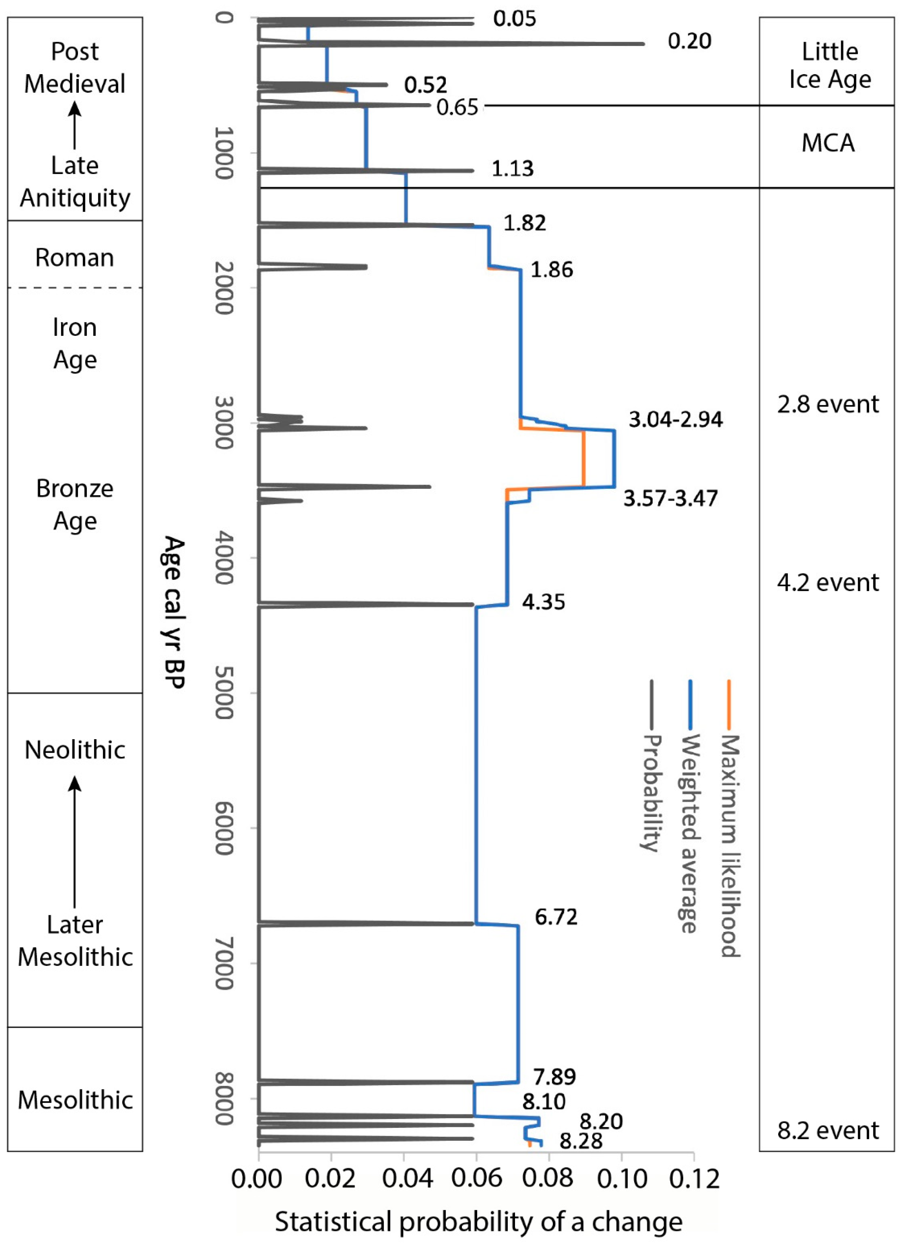
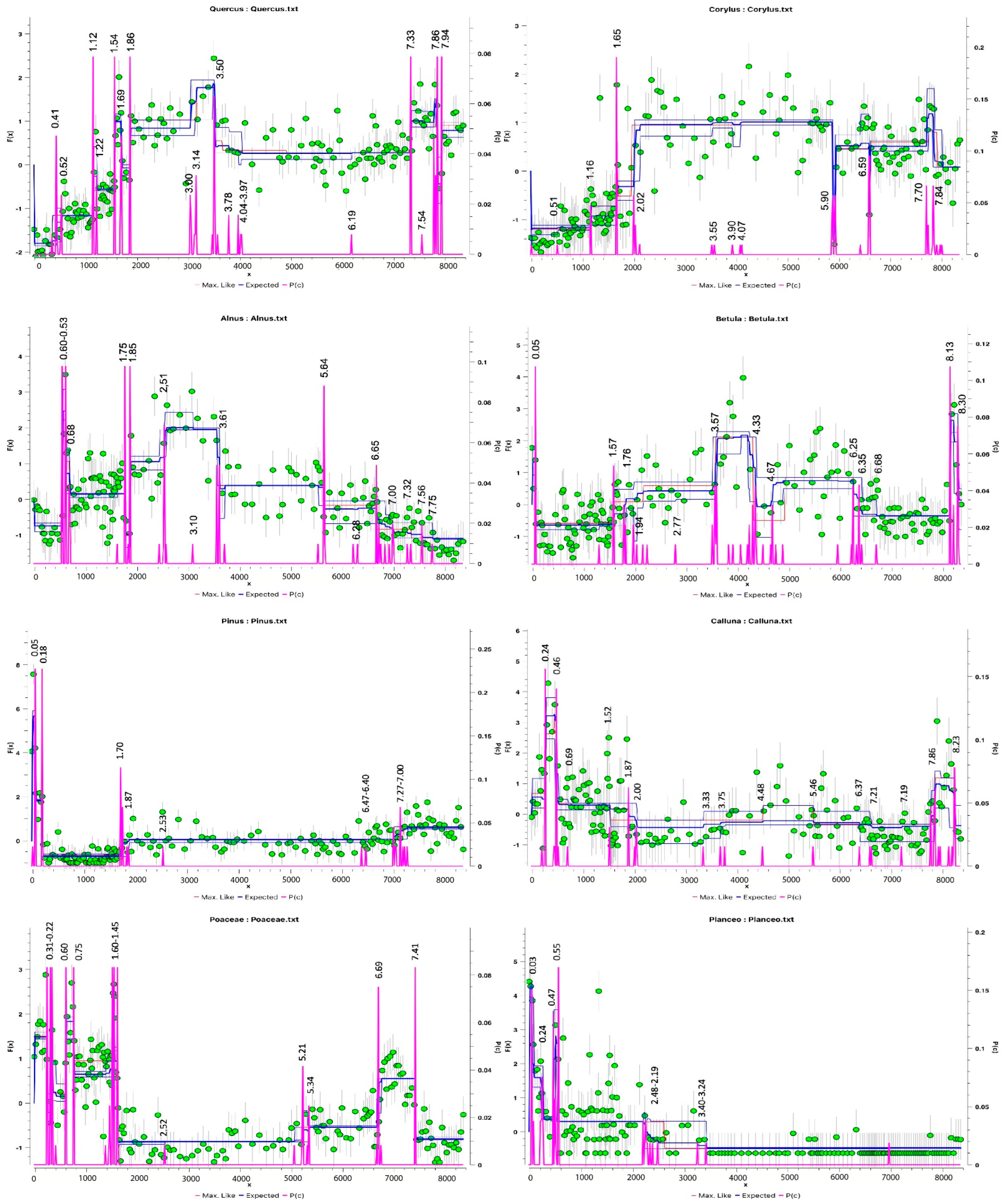
Changepoint (CP) modelling was applied to selected pollen (types with significant scores from the PCA) and humification data to assess statistically the significance of climatic and environmental changes more objectively [71] and has been applied successfully to other datasets from bogs [58,61]. This approach is based on Bayesian transdimensional Markov chain Monte Carlo [73]. has been undertaken on the principal pollen taxa both combined (Figure 6) and individually (Figure 7).

3.2. Geochemistry

Titanium (Ti) and Zirconium (Zr) display similar trends (Figure 8): prominent peaks c. 8100, c. 6080, an initially rapid and ultimately sustained rise in values between c. 4000 and c. 870 cal. BP and a large increase from c. 745 cal. BP to the present. Lead (Pb) concentrations show the typical record previously found regionally [74,75] and other areas of Europe [55] characterised by low concentrations (<1 µg g−1) until the beginning of the Iron Age (c. 2800 cal. BP), increasing to reach a maximum (17 µg g−1) in the Roman period, decreasing thereafter only to rapidly increase again in the last 500 years—peaking in the late 20th century AD (Figure 8).

3.3. Changes in Humidity in the Palynological and Peat Humification Record

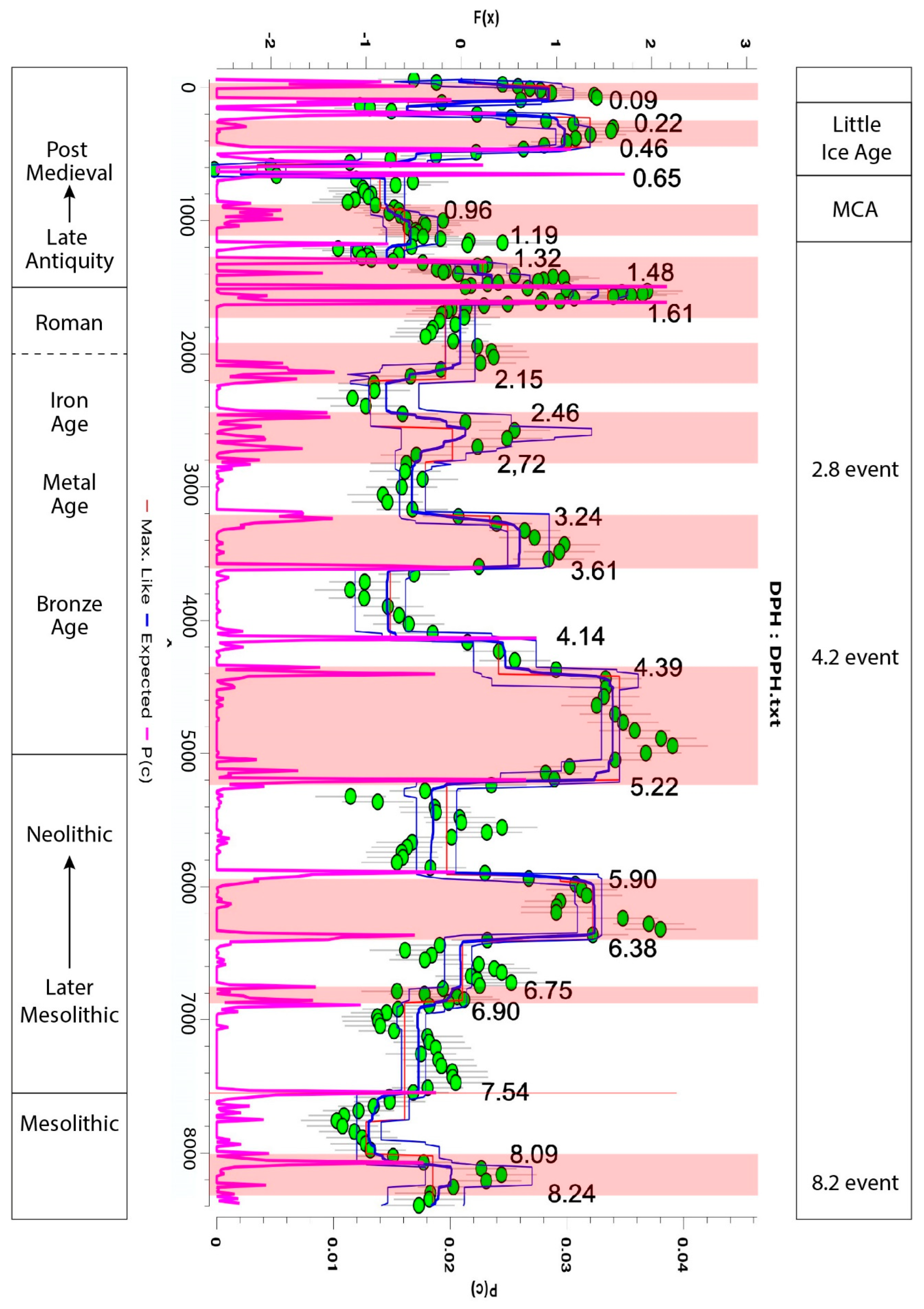
To examine the relationship between the behaviour of palynomorphs with climate, we used several independent proxies to derive evidence for peat decomposition and wet or dry bog surface conditions. The proxies used were: (1) the detrended peat humification transmission data. Notwithstanding, the possible limitations of reconstructing peat humification using UV-ABS [59], peaks, indicative of lower decomposition are most likely due to wetter conditions and lower values suggestive of increased decomposition and drier phases (Figure 8). (2) Changepoint analysis has been undertaken on the humification data (Figure 9) to reveal significant changes: 12 main dry shifts are identified: 8240–8090, 7540, 6900–6750, 6380–5900, 5220–4390, 3610–3240, 2720–2460, 2150–1900, 1610–1320, 1190–960, 460–220 and <90 cal. BP with wetter phases in between. (3) Selected palynomorphs considered to be sensitive to changes in bog surface wetness on this peatland based on earlier findings principally Cyperaceae and some NPPs (HdV10, 18, 306) [29]. PCA undertaken on the PDC data informed that for PDC2 the sum of ericaceous dwarf shrubs, Cyperaceae and HdV18 were best suited to decipher the climatic signal contained within the palynological record as they accounted for a larger proportion of the variance of the palynological dataset. These proxies for PDC2 are represented in Figure 8. The sum of Ericaceae and Cyperaceae show a negative co-variance for most of the record (e.g., at c. 8100 cal. BP, c. 4500 cal. BP and from c. 1700 to c. 630 cal. BP) but show inconsistencies again in the last c. 600 years. HdV18 shows a negative covariance with the sum of Ericaceae for most of the record while the other NPP proxies have quite specific records. HdV18 mostly covaries (negatively) with HdV10 until c. 4000 cal. BP when the latter sharply decreases and maintains very low values thereafter, except for a brief increase between c. 1360 and c. 920 cal. BP and by c. 90 cal. BP (Figure 8). HdV10 almost disappears completely whilst HdV18 remains stable at c. 4400 cal. BP and has a sizable short-lived increase at c. 750 cal. BP, and these slightly precede an increase in atmospheric dust deposition (by c. 3800 and 500 cal. BP). Conversely, HdV306 is absent in peat samples older than c. 3330 cal. BP, only to be continuously but irregularly present up until recent times (Figure 8). It shows distinctive peaks at c. 2700, c. 2120, c. 1360, and c. 430 cal. BP.

4. Discussion

4.1. Early Holocene (Upper Palaeolithic and Mesolithic, pre 7500 cal. BP)

The early stages of a temporary decrease in mesophilous Deciduous Quercus and Corylus and the short-lived increase of Betula and, to a lesser extent, Pinus in zone PDC2a coincide with the global, abrupt, cold and arid 8.2 ka climate event, characterised by a drop in temperature starting around 8600 cal. BP and spanning around 400 to 600 years [9,76,77]. The impact is registered in climatic records reconstructed across Iberia and further afield [19,78]. At PDC2, changepoints at c. 8240 and after 8090 cal. BP frames a dry shift (Figure 9). Similar vegetation changes occurred simultaneously with the 8.2 ka event in the Western and Eastern Cantabrian Mountains [79], as well as at other locations in Galicia and beyond [80,81]. Short-lived peaks in Poaceae also occur in nearby valleys around this time [34,82]. Changepoint analysis does not identify a significant change in Poaceae at PDC2 at this time (Figure 7) but the combined changepoint data (Figure 5) reveals significant changes took place between c. 8280 and c. 7890 ka cal. BP which probably marks the fluctuation in arboreal pollen percentages (and therefore forest abundance), and this is especially evident in individual analyses for Betula at c. 8300 and c. 8100 and Deciduous Quercus at c. 7940 to c. 7860 cal BP. Ti and Zr peak, signifying synchronous increased dust deposition [76] (Figure 8). Other non-climatic explanations to account for these vegetation changes include Mesolithic human activity, fires, and natural diseases in NW Iberia [79]. At PDC2, Calluna and Cyperaceae increased simultaneously (Figure 3b), suggesting heathland and/or peat developed in the newly open landscape, as forest cover declined.
Archaeological evidence for Mesolithic peoples present in the Xistral and Cantabrian Mountains is evident from a dense network of sites, including occupation of rock-shelters, caves and open-air sites [30,31,32,83], suggesting an intensification of human activity from 8500 BP onwards. It has been suggested that the passage to the coast as well as water resources/wetland exploitation may have been important control issues for these communities [31,33]. They are also characterised by using local lithic industry that indicates a good-knowledge and management of their territory. It is difficult to know what their relationship with the forest was, despite archaeological evidence suggestive of a human presence in humid and/or waterlogged areas around Xistral [84]. Firm evidence for human activity is not visible in the PDC2 microfossil record (Figure 3 and Figure 4) and does not detect any intensification of human impact just before, or during, the 8.2 ka climate event to invoke it as a cause of the decline in the deciduous oak-hazel forest. NAP taxa often associated with human disturbance are only recorded sporadically in trace amounts during zone PDC2a and some of these taxa could be late-glacial relicts. Apart from Sordariaceae, obligate coprophilous fungi, indicative of herbivores, are suppressed, only occurring either side of the decline of trees, although herbivores could have exploited this more open landscape [25]. Less intense human activity may have been due to some disruption caused by the 8.2 ka event to subsistence strategies [9,85,86] as activity was locally absent or of insufficient intensity to be registered in the PDC2 records. A modest increase in microscopic charcoal is recorded (Figure 8), a feature often observed on the Iberian Peninsula [87], but only after a fall prior to the loss of trees suggesting that wild or intentional fire was not a significant causal factor of the vegetation changes recorded between c. 8240 and c. 7935 cal. BP surrounding the mire, even though fires are part of the ecology of NW Iberia, typified by charcoal present in colluvial soils c. 8500–7000 cal. BP [88].
The predominantly deciduous oak-hazel forest (Figure 8) recovered rapidly and reached its maximum (based on pollen percentages) from c. 7850 to c. 7575 cal. BP, marked by a significant changepoint at c.7890 cal. BP (Figure 5) until the late Holocene, a pattern common during the Climatic Optimum [79,89,90]. Wetter climatic conditions coincide with dominance of arboreal pollen between c. 8090 and 7540 cal. BP. Forest cover then fluctuates between minor phases of expansion and regression throughout the mid-Holocene.

4.2. Later Mesolithic-Neolithic (c. 7500–5000 cal. BP)

Two phases of gradual forest regression occur between c. 7575 and c. 6880 cal. BP, the start and end of which are marked by significant shifts in humidity (Figure 9) and arboreal pollen (Figure 6). Significant shifts in bog surface wetness occur at c. 7540 cal. BP, indicative of wetter conditions and two suggestive of drier conditions at c. 6900 and c. 6750 cal. BP. Two changepoints at c. 7540 and c. 7330 cal. BP mark a decrease in Deciduous Quercus pollen (Figure 3a, sub-zone PDC2bi) and suggest that oak was the most adversely affected taxon although Corylus avellana-type also declines c. 7500 cal. BP. Following a brief recovery, a further suppression of forest cover from c. 6700 to c. 6165 cal. BP, marked by a combined changepoint at c. 6720 cal. BP (Figure 6), coincident with a shift towards drier conditions from c. 6750 cal. BP to c. 5900 cal. BP. At PDC2, bog/heath/grasslands expand into areas denuded of forest, as reflected by increased Poaceae, with a significant CPs at c. 7410 and c. 6690 cal. BP (Figure 7), the expansion of Ericaceae, with less significant CPs at c. 7210 and c. 6370 cal. BP, and regular percentages of Calluna and Vaccinium-type during the first phase. Fire could have played a role in gradually lowering tree cover as a series of large peaks in the microscopic charcoal record occur through PDC2bii enveloping the rise and fall in Poaceae. NAP indicators for human activity are restricted to sporadic, trace amounts suggesting that any activity was small scale and of insufficient intensity to drive any vegetation changes at this time [25,91] despite a series of studies suggesting rapid population growth between c. 7400 and c. 6750 cal. BP across Iberia [87,92,93]. Grazing is also less evident in the PDC2 NPP record, and by implication, the presence of ungulates [47,66,69]. A combination of climate and fire is most likely driving the vegetation changes during the early to mid-Holocene. A synthesis of charcoal records from Iberia also identifies the increased occurrence of fire between 7600 and 7000 cal. BP [87].
The second phase of reduced forest cover (Figure 8) reached a minimum at c. 6165 cal BP, then began to recover very gradually as arboreal percentages increase. Fagus is recorded for the first time (at the start of PDC2c) but never increases beyond trace amounts [79]. Synanthropic taxa continue to occur infrequently and/or in low values, whilst microscopic charcoal values are small compared to the first phase of reduced forest cover. One exception to these trends occurs at the top of sub-zone PDC2bii, c. 6025–5900 cal BP, and provides evidence for possible local human interference, when Corylus avellana-type, marked by a significant changepoint at c.5900 cal. BP, and deciduous Quercus values dip and correspond with increased Alnus and Betula (Figure 3a), and peaks in grazing indicators. This coincides with a slight rise in microscopic charcoal in contrast to the composite record of fires for Iberia [87]. A period of increased soil erosion is suggested by Glomus cf. fasciculatum chlamydospores (HdV207) (Figure 4), increased Zr and Ti (Figure 8). HdV 207 is a possible erosion marker, but some studies suggest this interpretation is not valid for peats as the spores could be produced from mycorrhizal mycelia related to their host plants rooted in the peat [94]. In this case, however, the Glomus spores do appear to be associated with disturbance and increased dust deposition, although there is a lack of herbaceous pollen indicative of human activity at this time.
Although there is evidence of an incipient human impact, the lack of cereal and pastoral pollen during the Later Mesolithic-Neolithic in the PDC2 core is consistent with the suggestion by Fábregas Valcarce et al. (2007) [95] and that an increasing number of early Neolithic sites were located away from the higher parts of the landscape even though higher ground continued to retain special significance for a long period [96]. Neolithic or Chalcolithic megalithic mounds and funerary monuments are relatively close to PDC (Figure 1b and Figure 10). Although these activities were not practised close to the PDC mire, phases of increased construction of large megalithic mounds are described for NW Iberia which could also have been an indirect influence on the observed anthropogenic forest modification, e.g., between 4900 and 4600 cal. BP [97]. No significant CPs are identified at this time in the PDC2 pollen data despite encompassing a dry shift between c. 5200 and c. 4390 cal. BP and no human remains have been found close to the Xistral Mountains [97]. Ramil-Rego (1992) also suggests that palynological evidence for human activity is scarce at higher altitudes and settlements are more abundant at lower altitude in the valleys [98]. The fluctuation in tree pollen at PDC2 is largely in agreement with two tree pollen maxima in the Western and Eastern Cantabrian Mountains: between 8000–7500 and 4500–2500 cal. BP, respectively, interrupted by a period of lower tree pollen percentages [79]. This is largely conditioned by climate dynamics, especially higher temperatures during the periods of tree pollen maxima and more variable and generally lower temperatures in between [79]. The PDC2 pollen record supports this idea as any human interference was of low intensity and the lack of significant CPs also suggests that forest cover was relatively stable.
While the lack of significant CPs between c. 6500 and c. 4000 cal. BP (Figure 6) suggests that these forests were relatively stable during the later stages of the Holocene climatic optimum and the beginning of the neoglacial period, individual arboreal taxa do show some changes. Corylus avellana-type pollen decrease and Betula increases during a dry shift between c. 6380 and c. 5900 cal. BP with both changes identified in the CP record (Figure 7). By c. 5765 cal. BP, arboreal pollen percentages increase at the start of zone PDC2c, coincident with a wetter phase based on the peat humification record (Figure 9), and show small fluctuations into PDC2di, implying more extensive tree cover through the end of the Neolithic and into the Chalcolithic period. Possible human disturbance phases occurred c. 5600–5500 cal. BP and c. 5250 cal. BP adversely affecting deciduous Quercus and Corylus avellana-type (zone PDC2c, Figure 3 and Figure 4), but changepoint analysis does not identify these as significant (Figure 6 and Figure 7) with exception of a small but sustained increase in Alnus at c. 5640 cal. BP. HdV55A/B, Sordariaceae and Glomus cf. fasciculatum chlamydospores (HdV207), Zr and Ti all increase. There is also a weak signal from selected non-arboreal anthropogenic indicators: all are represented in trace amounts (Figure 3b).

4.3. Metal Ages (c. 5000–2000 cal. BP)

In a nearby bog (Penido Vello, located within 5 km from PDC), a proxy record of climate change (temperature and humidity) for the last 5000 years, has been reconstructed by using the deposited atmospheric mercury [99]. The temperature index identified two major cooling phases (the Neoglacial period c. 5000 to c. 3000 cal. BP and the Little Ice Age) and two major warm periods (the Roman Warm Period [RWP] and Medieval Climatic Anomaly [MCA]). The humidity index suggests four major dry shifts occurred during the Metal Ages: at c. 5220–4390, 3610–3240, 2720–2460, 2150–1900 cal. BP (Figure 9). In contrast, wet periods were only detected in the PVO peat sections older than c. 3000 BP [99], suggesting that the humidity index based on Hg thermal lability may not be sensitive to wetness variations in cold climates, since this phase coincides with the Neoglaciation period and the index also shows low values during the LIA; but it also may be influenced by the fact that this section of the PVO core is at a lower resolution—every 5 cm—and some wet events may have been averaged out. However, the importance of humidity rather than temperature as a climatic parameter reflects the strong oceanic nature of the sub-coastal mountains, which are not only close to the sea but also subject to a continuous advance of cyclonic fronts [23,82,100,101,102].
The CPs at c. 4390 and c. 4140 cal. BP envelopes the ‘4.2 Ka event’ which is an abrupt change in which climate became colder and drier and acts as a marker from the warmer middle Holocene to the cooler late Holocene [103]. At PDC2 peat humification (dPH) is still relatively high implying drier conditions (Figure 9). However, the trend is one that is becoming wetter (a sharp decline in the sum of Ericaceous dwarf shrubs and HdV10; Cyperaceae and subsequently, HdV18, increase in value) between c. 4400 and c. 4000 cal. BP (Figure 8). Wet shifts are also recorded during this time in other bogs in Galicia [23,104,105,106]. The likely cause of this abrupt cold event (Bond event 3) is a response to decreased solar activity [107]. Stefanini et al. (2019) suggest that a period of cold conditions occurred before becoming drier between c. 4000 and c. 3350 cal. BP [23]. A dry phase occurs between c. 3610 and c. 3240 cal. BP. This climatic transition is coincident with a phase of local burning from c. 4400 cal. BP thought to be the result of human-induced fires coinciding with increased settlement activity at higher elevations during the third millennium BC23. Microscopic charcoal values also increase slightly at PDC2 towards the top of PDC2di, but NAP taxa associated with human activity are sparse suggesting that humans had minimal impact on vegetation (Figure 3).
Forest expansion at PDC2 starts slightly before the ‘4.2 ka, Bond 3 event’. From c. 4440 to c. 3135 cal. BP, tree cover gradually expands and the timing of this episode of forest expansion coincides with the second tree maximum (between 4500 and 2500 cal. BP) in the Western and Eastern Cantabrian Mountains [79]. At PDC2, deciduous Quercus, Betula and Alnus all increase during PDC2dii, marked a combined changepoint at c. 4330 cal. BP (Figure 6). In contrast, Corylus avellana-type peaks on the sub-zone boundary (di/dii) then declines (PDC2dii), before increasing as deciduous Quercus declines (first part of PDC2diii) (Figure 3). Cereal-type pollen is recorded with trace amounts of some coprophilous fungi, but other NAP taxa indicative of human activity are scarce as total tree percentages increase implying a lack of human activity close to PDC mire. A sudden increase in the lithogenic elements at c. 4000 cal. BP at PDC2 is recorded (Figure 8) and this could reflect more regional-scale soil erosion [8]. These changes correspond with a period of less intense human activity during the Copper Age-Early Bronze Age and are not always marked by significant changepoints.
Regionally, the Bronze Age was a time of increasing human pressure to the environment in NW Iberia [108]. However, based on the PDC2 arboreal pollen data, forests remain the dominant land cover with only minor changes in composition and expand up to c. 2750 cal. BP (beginning of Iron Age) which may in part have been facilitated by a dry phase as recorded in the CP analysis between c. 3610 and c.3240 cal. BP (the Middle Bronze Age). Betula pollen declines at c. 3570 cal. BP, deciduous Quercus sharply increases at c. 3500 cal. BP as Corylus avellana-type decreases: composition changes identified by a combined changepoint at c. 3570–3470 cal. BP and individual ones for the tree taxa (deciduous Quercus, Alnus and Betula) between c. 3600 and c. 3500 cal. BP (Figure 5 and Figure 6). Communities are thought to have preferred deciduous Quercus wood, combined with shrubby species of the Fabaceae (Leguminosae) family, while other species such as Corylus avellana flourished in the open landscape after deforestation [109]. Acorns (deciduous Quercus) have been reported as the only wild fruits consistently present in the archaeological sites [108]. Deciduous Quercus appears to be prominent as pollen percentages occur to Holocene climatic optimum levels until c. 1900 cal. BP. From c. 3500 cal. BP, NAP taxa associated with human activity are consistently present at PDC2 (Figure 3b) indicating that land was probably being cultivated and used for pasture, and the first significant CP for Plantago lanceolata occurs between c. 3400–3240 cal. BP (Figure 7). This activity was probably of low intensity during the Early Bronze Age and increased during Mid Bronze Age. Soil erosion continued as Ti and Zr values suddenly increased and Glomus cf. fasciculatum chlamydospores are recorded [50]. Calluna percentages also increased, noticeably after c. 4000 and c. 3000 cal. BP, suggesting that heath/peatlands expanded in areas cleared of forest.
Archaeological evidence strongly suggests that people were present in the Xistral Mountains and more widely during Bronze Age [64], as evidenced by ceramics, lithics, the reuse of megalithic burials (tumuli and dolmens) [110] (Figure 10), rock art from the late third and second millennium BC [111] and numerous artefacts [112]. More productivity and the number of settlements in Mid and Late Bronze Age have been the main drivers of increased soil erosion and the creation of new colluvio-alluvial soils in the valleys 81,108. Settlement diversification in NW Spain includes the progressive occupation of mid/high altitudes, which became the norm later in the Iron Age [110]. The observed differences in settlement pattern between lowlands and highlands, with exploitation in the coastal areas and valleys from Early/Middle Bronze Age, and the increase of pressure on mountain areas at the end of Bronze Age, may explain the pattern recorded at PDC2 in terms of land use and erosion [113].
Late Bronze Age communities were active in Galicia [112]. Forest cover first began to decline very gradually and then permanently from c. 3135 cal BP marking a critical 3000 BP (1000 cal. BC) threshold. Data from various proxies are indicative of an acceleration of environmental degradation in NW Iberia [50,81]. Significant CPs in the composition of vegetation coincide with this event, dated to c. 3040 and c. 2940 cal. BP (Figure 5) as climate becomes wetter with a significant changepoint at c. 3240 cal. BP (Figure 9). Major changes in agricultural practices and landscape transformation have been identified in the archaeological record, such as the arrival of millets, that possibly became staple from Late Bronze Age onwards and marked the difference with the previous Chalcolithic period [108]. Human activity is persuasive at PDC2, oak woodland continued to be cleared. Deciduous Quercus percentages fall (marked by changepoints at c. 3140 and c. 3000) coincident with an initial increase in Betula, Alnus and Corylus avellana-type, possibly taking advantage of some newly cleared ground (PDC2diii). Similar declines in forest cover have been found around archaeological sites from Northern Portugal [110], with the use of acorn as part of human diet [108,114]. Forest clearance around c. 3000 BP also coincides with a period of metal transformation and trade in NW Iberia based upon numerous metal objects [110] but of insufficient intensity to show in the Pb profile from PDC2 (Figure 8). Near continuous records of anthropogenic indicators occur and Poaceae is well represented (Figure 3b). Pasture is also indicated by the presence of a suite of coprophilous fungi (Figure 4) albeit in low values and sporadically. Cereal-type pollen is not recorded at PDC2 for some considerable time (the end of PDC2dii and the lower half of PDC2diii and possibly due in part to poor dispersal of cereal pollen) beforehand and only recommenced after the event. This suggests that the dominant land use was pasture during the Late Bronze Age in the local area, but it ceased to be practiced, albeit briefly, across the transition to the Iron Age and an emerging hillfort culture [115]. Forest clearances, an expansion in agriculture and livestock grazing, and metallurgical activity, occur both in the uplands and at lower altitudes across the Cantabrian Mountain range and more widely in NW Iberia from the Bronze Age to the Roman period [29,79,81,89,90,116]. The role of climate influencing the changes in vegetation is difficult to ascertain. Some CPs overlap and it is possible that there could be a time-lag effect in the response of vegetation. These can exhibit some variability due to vegetation and climate characteristics [117].
Changing land use patterns have been suggested elsewhere due to climate change during the LBA [118,119,120] and a similar situation could apply here although human activity appears to be the main driving force in altering vegetation. This is supported by a change in the archaeological record. Funerary monuments in the region turned to a more discrete materiality, caves and cists [96,121,122]. Despite not being close (>100 km), the two studied caves with human remains reflect a complex lifestyle in the Mid Bronze Age with a homogeneity in diet that contrasts with the increase in territoriality during the period. Limited consumption of animal protein points to lower livestock activity [122]. The practice of cremation during the whole of the Bronze Age, apparently coexisting with inhumations [96,121], could have had an impact on local forest coverage for the wood fuel demand.

4.4. Iron Age

The Iron Age (2750–2000 cal. BP), typified by the construction of hillforts (castros) across the region, which are believed to have resulted in full sedentarisation of the mountainous areas of NW Iberia (Farci et al., 2017). The LBA/Iron Age transition at PDC2 is characterised by minor changes in vegetation coincident with the 2.8 ka (c. 850 cal. BC) ‘climatic event’ when there was an abrupt change from a continental to oceanic climate [123,124] between c. 2750–2450 cal. BP [125]. This is characterised by shifts between wet and dry conditions from c. 3240 to c. 2460 cal. BP at PDC2. A major shift in climate (humidity) was also identified at c. 2850 cal. BP [99]. As the 2.8 ka cal. BP event was ending, c. 2460 cal. BP, climate became wetter based on humification data (Figure 9) at PDC2 which is also hinted at (notwithstanding spatial variations of wetness on the bog surface) with NPPs associated with drier conditions more noticeable at the start of PDC2diii such as HdV59, 306, 733 declining and those linked to wetter conditions (HdV28) more prominent (Figure 4).
The vegetation changes at PDC2 are not considered significant by the CP analysis and these activities were possibly affected by socio-political devolution in the region as Atlantic trade was dislocated [112] and might explain the lack of changes in the PDC2 records. Despite this, there is evidence of human activity associated with changes in the pollen record described following the events described above between c. 3040 to c. 2940 cal. BP. These might be associated with the 2.8 ka cal. BP event. Following those changes, characterised by a decrease in Deciduous Quercus, forest abundance recovers. The pattern is then one of gradual forest decline with Corylus avellana-type, Betula (2770 cal. BP) and Alnus (2510 cal. BP) most affected at PDC2 (Figure 8) recognised by some significant changepoints (noted in brackets). Other changes include an increase in Ulmus and the more regular presence of Fagus. Cereal-type pollen provides evidence of cultivation by c. 2500 cal. BP and pasture and disturbance indicators are frequently recorded (Figure 3b), including a suite of coprophilous fungi. Similar patterns of forest clearance for agricultural purposes [82] are recorded elsewhere in Galicia [126,127] and as recorded in the Cruz do Bocelo mire [22]. Microscopic charcoal values peak at the start of PDC2diii then gradually decline thereafter suggesting fire was not extensively used to clear forests in the vicinity of PDC. Titanium and Zr values dip suggestive of lower dust deposition and lower rates of soil erosion c. 2800 cal. BP, also recorded nearby at Tremoal do Pedrido [71] reflecting a reduction in agriculture, before increasing to reach their highest level since c. 5900 cal. BP (Figure 8).

4.5. Roman Period (c. 2000–1500 cal. BP)

The start of the Roman period is marked by a shift from wet to drier conditions which persist until the transition to the Medieval period, during the Roman Warm Period [107]. The impact of Roman culture on the land cover was very severe, with a rapid phase of deforestation, c. 1950 cal BP (start of PDC2e, Figure 5). Significant CPs are recorded during this time for individual trees and the combined analysis (Figure 6 and Figure 7). Titanium and Zr peak (Figure 8) and simultaneous higher percentages of Poaceae and trace amounts of cereal-type, Plantago lanceolata, Amaranthaceae, Apiaceae and Pteridium (Figure 3b) suggesting widespread forest clearance and an intense period of soil erosion and human activity that lasted until 1790 cal. BP. Similar but less pronounced short-lived changes have been identified elsewhere around this time [22]. Whilst there is clearly evidence of agricultural activities, including cultivated trees (e.g., Oleaceae), very few coprophilous fungi are recorded suggesting that there was not an intensification of upland grazing. A stronger response is registered in taxa associated with heath and peatlands. A more significant demand for wood was probably created by the mining and metallurgical activities and these activities led to the further demise of the region’s forests rather than agricultural expansion in the uplands [128,129,130,131,132,133]. Figure 8 shows that Pb concentrations are elevated from the Late Iron Age to the Roman period, the pattern of which is replicated by the Pb/Ti ratio (Supplementary Material Figure S3) which is typical in records from this region [74,75,129,130,131,132,133] and across Iberia and Europe [55,134]. The increase of wood-demand by specific activities, such as mining and metallurgy, is enhanced in Roman times by quotidian ones such as the cremation of corpses as funerary ritual. To burn a body, a sizeable quantity of wood is required. There is no specific data about the species used, but deciduous Quercus sp. (deciduous), Fraxinus sp. and Pinus sp. have been found in primary pyres from this period [135]. There are no typical Roman constructions and settlements in the area; however, most hillforts were occupied at least until the 2nd century AD. Inland locations may have been in use until post-Roman times, revealing a panorama of intense occupation in the valleys west of the PDC mire [136].
A short-lived phase of forest regeneration occurs by c. 1790 cal. BP. Evidence for both arable and pastoral agriculture are less definable in the pollen and NPP records (latter half of zone PDC2e). This could be linked to the crisis of the third century during the Roman Empire. The recovery of forest cover is short-lived and by c. 1690 cal. BP, towards the end of the Roman period, there is a second episode of rapid deforestation (Figure 8). This marks a significant change as forest is converted to grassland permanently. Fire was possibly used to aid this process as peaks in microscopic charcoal occur at the start and end of the zone. This irreversible decline in forest cover affected large parts of the region as recorded in soil profiles and peat archives between c. 1500 and c. 1200 cal. BP ([22,24] and references therein). Both the recovery and permanent decline in oak-hazel forest is marked by a series of CPs (Figure 5 and Figure 6). These changes partly coincide with a drier phase between c. 1600 and c. 1480 cal. BP. A climatic shift occurred at 1400 cal. BP possibly related to changes in the North Atlantic thermohaline circulation [137].

4.6. Late Antiquity, Middle Ages and Post-Medieval Times (1500 cal. BP-Present)

The gradual decrease in Ti and Zr values occurs from c. 1690 to reach minimum values c. 745 cal. BP (Figure 8). Thereafter they increase rapidly before deposition rates slow down c. 430 cal. BP and finally peak 200 years ago: this increase is coincident with the Little Ice Age (LIA; Mann, 2002; Oliva et al., 2018). The onset of the LIA is marked by a short-lived recovery in forest cover (Figure 8). It has been suggested that temperatures rose in the early to mid-AD 1500s (c. 400 cal. BP) [79] which might explain the increase in forest cover at PDC2 (top of PDC2f) with climate being most severe in the late 16th and 17th centuries. A reduction in grazing intensity (as only Podospora-type is recorded) would also have facilitated renewed forest expansion. Whether these events are linked to the onset of the LIA is yet to be established. Increased dust deposition during the LIA has also been found in ombrotrophic peatlands across Europe [55,138,139] and Greenland [53,140] suggest increase in soil erosion processes linked to the Maunder minimum in solar activity were detected in a Mediterranean minerotrophic peatland [141]. To solely attribute the increase in soil erosion to climate change is problematic as other studies interpret increased dust as human induced soil erosion to create pasture and cropland [22,50,141,142]. Evidence for the removal of forest, cultivation and pasture as well as the expansion of heath and/or peatlands (Figure 8) occurs in the PDC2 pollen record during the LIA onwards, indicated by significant CPs for Calluna, Poaceae and Plantago lanceolata in the last 750 years (Figure 7). The number of short-lived shifts from 650 cal. BP (Figure 9) from wetter to drier phases and vice versa also possibly reflect changes in temperature described throughout the Little Ice Age commencing with a colder phase between 1300 and 1480 cal. AD (750–570 cal. BP) and culminating in the increased temperatures post 1850 cal. AD (200 cal. BP) [143].
Climate change, deforestation and soil erosion have also been linked to changes in diet and way of living in the NW Iberia through the analyses of human remains. Strong modifications in diet and use of C4 plants in NW Spain were related to socioeconomic decline but also to regional climate deterioration [144]. Deforestation and increased soil erosion seem to have been also the main causes for some port collapses during LIA in the region, resulting in changes in lifestyle in the Medieval coastal village of Pontevedra [144]. However, there is still a need for a wider discussion on the link between vegetation and climate proxies and the everyday life of people.
Notwithstanding an occasional reversal (e.g., at c. 1250–1130 and c. 650 cal. BP), forest cover continues to decline throughout the Middle Ages into the historical period (PDC2f). The increase in microscopic charcoal in PDC2f suggests fire was used to suppress forest cover. Demand for wood increased for use in construction, ship building and iron foundries [79,89]. The landscape surrounding PDC2 is dominated by grassland and heath/peatland. Agricultural land use and disturbance intensifies with more regular and higher amounts (especially in PDC2g; Figure 5) of cereal-type and pasture/disturbance indicators which reflects a land economy based upon sheep/goat production from the Middle Ages to the late 16th century [79]. Cultivated trees also feature regularly throughout PDC2f and g. Microscopic charcoal values are at their highest level since the early mid Holocene. Fire clearly played a role in forest clearance and occurred on drier parts of the heath and/or peatlands. NPPs affiliated to drier conditions are prevalent, with Gelasinospora (HdV1/2), HdVs 6, 10, 14 and 52 often recorded (Figure 4). Pinus increases in the last zone because of recent afforestation during the past two centuries (Figure 3 and Figure 7: CPs at c.180 and c.50 years ago) but commences c. 500 years ago as Ti and Zr rise to a Holocene maximum, supporting the idea that pine plantations do not prevent soil erosion as effectively as mesophilous forest [22].
From Roman times onwards, oat and small quantities of wheat have been grown in the Xistral Mountains. The quartzite that dominates the Xistral makes for poor soils unsuitable for agriculture. Millet, popular since the Iron Age, is a good option to obtain cereals in the summer season. Wheat, barley, oats, and millet were the most used cereals; while rye farming did not become important until the Middle Ages [145,146]. Traditional agriculture was based on three staples: leguminous plants (beans and peas), different kinds of cabbage, and cereals [146]. In mountainous inland areas of this region, chestnut, livestock and cereals were possibly the base of the economy, while wine was limited to valleys and decreased in importance after the 16th century [147,148]. Contrary to what happened in other areas of NW Spain, where Castanea increases from Roman times, the exploitation of sweet chestnut started here in Late Antiquity (c. 1500 cal. BP) and is possibly related to the establishment of new management policies (Ecclesiastical and nobility management of mountain areas). To our knowledge, no mention of olive trees has been found in historical texts and carpological analyses in the study area [145]. Regarding livestock in the Xistral Mountains, Medieval and post-Medieval times were dominated by caprine (sheep and goats), followed by bovine and pigs [147].
The sampling site is embedded into Mondoñedo province that contains one of the most important dioceses in NW Spain, and key to understanding the evolution of the local-regional landscape in the historical period. The results presented here for post-Roman times and onwards have a clear link with historical evolution of this diocese. It is believed that the Christian dominance in the area dates to the 2nd century AD, although there is not a clear mention to the Britoniam diocese until the Lugo Concilium in AD 569/1381 cal. BP (preceding the Mondoñedo one) [149]. The area was conquered by Abd-el Aziz in AD 716, who made it “uninhabitable” according to the historical texts [149] and coincides with a short recovery in the AP percentages (c. 1254 cal. BP). After this crisis, the diocese was placed on the coast, at the current village of Foz. The Mondoñedo bishops ruled after AD 864 just when arboreal pollen started to decline again, dominating a vast area that comprises a series of churches (e.g., the close Cadramón church) surrounding the Xistral Mountains. The population, mainly located at the coast, was slowly moved inland due to the instability of the seaside villages created by the Norsemen, Vandals and Islamic groups invasions [149]. This led to a constant increase in agriculture in valleys. Small crises lasted until the 12th century AD when the diocese moved to its current location inland (~20 km from PDC). The 12th and 13th centuries are characterized by a large intensification of agriculture with the expansion to new lands and the consequent increase on demography (Saavedra 1985). The fact that these advances are mainly restricted to lowlands can explain why there is not a clear connection to arboreal percentages at PDC2. Major socioeconomic changes are documented during the 14th and 15th centuries with depopulation, famine episodes and the arrival of the plague to inland NW Spain [148,150]. It has been determined that these crises lasted longer here than in other Spanish regions [147]. From AD 1500 onwards (450 cal. BP), there is a slow recovery of the agriculture and demography; however, population density in the mountainous area of the Xistral never exceed 15–18 inhabitants/km2 (values for the 16–18th century, with lower economy than that observed for other Galician mountains [147]). Variations in agrarian use and demography seem to have affected the surrounding valleys, while mountains were not so much exploited. However, there is a change in management during the 16th and 17th centuries when permissions to deforest are given and the council recommended occupation of the highlands. In consequence, forests were cleared for agriculture and livestock activities [147]. Again, during these centuries, wood was traded with Lisbon and Seville ports. Historical texts indicate that the poorest neighbourhoods cleared the forest for their livelihood, cutting Deciduous Quercus and Castanea, but also Fraxinus and Populus nigra; these were sent abroad to, but not only, manufacture armaments and ships [147]. The pollen record reflects this sizeable clearance of woodland with a tree pollen minimum at c. 265 cal. BP (Figure 8). At that point, the mountain area had increased its capacity to support farming activities, enhanced with the arrival of new products such as potatoes. Woodland here only recovered with the pine plantations and people migrating to urban areas during the last two hundred years (Figure 8).

5. Conclusions

To disentangle definitively the respective roles of climate change, human activity and other factors that have influenced the development of vegetation during the Holocene is problematic. To address this challenge requires well-dated, high-resolution, multi-proxy datasets. We have presented a fine resolution, multi-proxy dataset that provides additional insights into drivers of vegetation change and the response to those impacts on vegetation composition and, to a limited extent, cover. Furthermore, the use of changepoint analysis, alongside other numerical analyses, proved useful to determine significant changes in both the pollen records and the humification data. This allowed us to examine a combined response to vegetation changes using the main pollen taxa but also to identify individual behaviour. Thus, we conclude that vegetation changes in the Xistral Mountains of NW Spain seem to have been driven by climate, fires and human activity over the last 8500 years. Evidence for the effects of climate change is more prominent in the early Holocene when human impacts are minimal. The most conspicuous feature of the early Holocene is a marked, albeit short-lived, period of vegetation change coinciding with the 8.2 ka event, characterised by a decrease in mesophilous forests and increase in Betula (and Pinus to a lesser extent), coeval with increased dust deposition, which framed the 8.2 ka event.
Climate and fire interactions appear to be an important influence shaping the types of land use cover during the early Holocene. A shift towards drier conditions may have induced more frequent fires, characterised by large peaks in microscopic charcoal, point towards fire and climate, as the most likely drivers of vegetation between c. 7500 and c. 6500 years cal. BP. Vegetation changes do not appear to have been driven by human activity using fire as a land management strategy as it was of small scale and of low intensity despite changes in forest cover occurring through both expansions to reach a Holocene maximum and regression between c.7575 and 6165 cal. BP. The exception is a possible human interference by c. 6025–5900 cal. BP-coinciding with Megalithic culture-attested by the decline in deciduous Quercus and Corylus, and the increase in Alnus and Betula, NPP indicators of grazing, microscopic charcoal and proxies of soil erosion.
More abrupt climate changes such as the 4.2 and 2.8 ka events appear to have had less significant impact on vegetation compared to the 8.2 ka event in terms of forest composition and the expansion and/or contraction of different land uses, but the dating resolution in this study needs further improvement before we can definitively dismiss its influence. The beginning of the Late Holocene is marked by the expansion of the forests (from c. 4440 to c. 3135 cal. BP) leading to a second Holocene maximum in forest cover. This appears to have commenced before 4200 cal. BP. Changepoint points occur just prior to this date for the collective analysis of the min pollen taxa and there is no consistent pattern evident for the individual records. A downturn in microscopic charcoal suggests fire was not a major factor.
Human activity plays a more influential role in vegetation change from c. 3500 cal. BP (Middle Bronze Age) which culminates in the permanent loss of forest c. 1500 cal. BP (Late Antiquity) to create arable land and pasture (albeit of low intensity) during the Early Bronze Age but increasing during the Mid Bronze Age. A sudden raise in soil dust deposition provides evidence of intensified soil erosion and colonization of the areas of cleared forest. Forests started to decline gradually since c. 3135 cal. BP, with many proxies indicating acceleration of environmental degradation in NW Iberia. There is indication of expansion of pasture during the Late Bronze Age, but it ceased to be practiced briefly across the transition to the Iron Age. The additional increase in the intensity of human activity makes it more difficult to discern any climate-related influences. It is noteworthy a sequence of humification shifts is revealed in the changepoint data: dry shift occurs at c. 3610 until 3240 cal. BP before becoming wetter at 3240 until 2720 cal. BP when it shifts towards drier conditions. These shifts envelope two changepoints at c. 3570 and 2940 cal. BP in the main pollen taxa. Establishing a direct cause and effect relationship is not possible but this does suggest a possible climatic influence on vegetation even though there are no major changes evident in the pollen diagram except for a rise in Calluna pollen suggesting an expansion of heathlands and/or peatlands.
A similar conclusion can be forwarded for the 2.8 ka cal. BP event which seems to occur over a shift from wet to dry conditions and following the uppermost changepoint described above. Human activity was probably, for the first time, the main driving force in altering vegetation during the Iron Age, with cereal pollen providing evidence of cultivation by c. 2500 cal. BP, coincident with indicators of pasture and disturbance. Climatically, the phase contains the 2.8 ka event, during which minor changes in vegetation were noted but a clear intensification in soil erosion towards the drier phases. Human activity remained persuasive during the Roman period (c.2000–1500 cal. BP), with a suite of intense changes: rapid deforestation, enhanced soil erosion, expansion of Poaceae, forest clearance, increased metal (Pb) pollution and agricultural activities. Despite this, no intensification of grazing in the uplands seems to have occurred. A short-lived forest regeneration occurred by c. 1790 cal. BP, but by c. 1690 cal. BP a second episode of rapid deforestation was detected, together with evidence of arable and pastoral agriculture, cultivated trees, and high rates of soil erosion. The weight of evidence across the various proxies points firmly towards human activity but these changes do occur against a series of climatic wet/dry shifts. A comparison of the main changepoints suggests that the humification record does not match the major changes in the pollen record favouring human activity driving vegetation change.
Since Late Antiquity (<c. 1500 cal. BP) environmental evolution is complex, with significant climate changes (e.g., Medieval Warm Period—Little Ice Age climate anomaly), intensification of fires and increased human pressure. Forests were at their minimum cover except for short-lived recoveries (as during the LIA) and the recent afforestation with Pinus and Eucalyptus plantations. As human activity intensified, especially in the Late Holocene, it is difficult to disentangle the respective roles (climate, fire, humans, competition) in causing vegetation change, complicated by the possibility of time-lag effects but human activity seems to be the dominant driver. However, shifts in the humification record correlate with the start of each cultural period. The significance of this pattern from Late Antiquity has yet to be fully established but the main changepoints from the humification and pollen records do not show a strong degree of synchroneity.

Supplementary Materials

The following supporting information can be downloaded at: https://www.mdpi.com/article/10.3390/quat6010005/s1, Figure S1a: Percentage pollen diagram for trees, shrubs, dwarf shrubs, preservation and microscopic charcoal from PDC2 peat core; Figure S1b: Percentage pollen diagram for herbs and spores from the PDC2 peat core; Figure S2: Percentage diagram for non-pollen palynomorphs from the PDC2 peat core; Figure S3: Pb/Ti ratios for the PDC2 peat core. Age in cal. BP on the x-axis. Table S1: Zone/sub-zone characteristics for PDC2 (AP = arboreal pollen; NAP = non-arboreal pollen); Table S2: Scores of the PC extracted in the dataset. Only scores greater that 0.5 (absolute value) are included.

Author Contributions

Conceptualization, T.M.M. and A.M.C.; methodology, T.M.M. and A.M.C.; software, T.M.M. and A.M.C.; formal analysis, T.M.M. and A.M.C.; investigation, T.M.M., A.M.C., O.L.-C.; resources, T.M.M. and A.M.C.; data curation, T.M.M., A.M.C. and O.L.-C.; writing—original draft preparation, T.M.M., A.M.C. and O.L.-C.; writing—review and editing, T.M.M., A.M.C., N.S.-S. and L.L.-M.; visualization, T.M.M., A.M.C., O.L.-C., N.S.-S., L.L.-M.; project administration, A.M.C. and T.M.M. All authors have read and agreed to the published version of the manuscript.

Funding

O.L.-C. is funded by a Ramón y Cajal senior fellowship (RYC2020-030531-I) and the project “Pollutio” Plan Nacional (PID2019-111683RJ-I00) Spanish Ministerio de Ciencia e Innovacion. O.L.-C. and A.M.C. are funded by “Grupos de Referencia Competitiva” (ED431C 2021/32) by Xunta de Galicia. N.S.-S. is funded by a Juan de la Cierva-Formación Grant from the Spanish Government (ref: FJC2018-036266-I). L.L.-M. is supported by the Programa de Atracciόn de Talento modalidad 1 (2019-T1/AMB-12782; ECOSINK project) funded by the Comunidad de Madrid. L.L.-M., T.M.M.and A.M.C. are funded by the project PALAEOFUN from the Plan Estatal (PID2020-115580RB-100), Spanish Ministerio de Ciencia e Innovaciόn.

Institutional Review Board Statement

Not applicable.

Informed Consent Statement

Not applicable.

Data Availability Statement

Data can be obtained by contacting the lead author.

Acknowledgments

Authors want to thank Pilar Prieto Martinez for her suggestions during the writing process. We thank Pedro Rivas López for performing the DPH measurements.

Conflicts of Interest

The authors declare no conflict of interest.

References

  1. Cullen, H.M.; Demenocal, P.B.; Hemming, S.; Hemming, G.; Brown, F.H.; Guilderson, T.; Sirocko, F. Climate change and the collapse of the Akkadian empire: Evidence from the deep sea. Geology 2000, 28, 379–382. [Google Scholar] [CrossRef]
  2. DeMenocal, P.B. Cultural responses to climate change during the late Holocene. Science 2001, 292, 667–673. [Google Scholar] [CrossRef] [PubMed]
  3. Drysdale, R.; Zanchetta, G.; Hellstrom, J.; Maas, R.; Fallick, A.; Pickett, M.; Cartwright, I.; Piccini, L. Late Holocene drought responsible for the collapse of Old World civilizations is recorded in an Italian cave flowstone. Geology 2006, 34, 101–104. [Google Scholar] [CrossRef] [Green Version]
  4. Fiorentino, G.; Caracuta, V. Third millennium B.C. climate crisis and the social collapse in the Middle Bronze Age in Syria highlighted by carbon stable isotope analysis of 14C-AMS dated plant remains. Quat. Int. 2007, 127–128, 19. [Google Scholar]
  5. Rosen, A.M. Civilizing Climate. Social Responses to Climate Change in the Ancient Near East; Altamira Press: Lanham, MD, USA, 2007. [Google Scholar]
  6. Bar-Matthews, M.; Ayalon, A. Mid-Holocene climate variations revealed by high-resolution speleothem records from Soreq Cave, Israel and their correlation with cultural changes. Holocene 2011, 21, 163–171. [Google Scholar] [CrossRef]
  7. Roberts, N.; Eastwood, W.J.; Kuzucuoğlu, C.; Fiorentino, G.; Caracuta, V. Climatic, vegetation and cultural change in the eastern Mediterranean during the mid-Holocene environmental transition. Holocene 2011, 21, 147–162. [Google Scholar] [CrossRef]
  8. Lillios, K.T.; Blanco-González, A.; Drake, B.L.; López-Sáez, J.A. Mid-late Holocene climate, demography, and cultural dynamics in Iberia: A multi-proxy approach. Quat. Sci. Rev. 2016, 135, 138–153. [Google Scholar] [CrossRef] [Green Version]
  9. Griffiths, S.; Robinson, E. The 8.2 ka BP climate change event and human population resilience in northwest Atlantic Europe. Quat. Int. 2018, 465, 251–257. [Google Scholar] [CrossRef]
  10. Caseldine, C.J.; Turney, C. The bigger picture: Towards integrating palaeoclimate and environmental data with a history of societal change. J. Quat. Sci. 2010, 25, 88–93. [Google Scholar] [CrossRef]
  11. Berglund, B.E. Human impact and climate changes—Synchronous events and a causal link? Quat. Int. 2003, 105, 7–12. [Google Scholar] [CrossRef]
  12. Magny, M. Holocene climate variability as reflected by mid-European lake-level fluctuations and its probable impact on prehistoric human settlements. Quat. Int. 2004, 113, 65–79. [Google Scholar] [CrossRef]
  13. Arbogast, R.M.; Jacomet, S.; Magny, M.; Schibler, J. The significance of climate fluctuations for lake level changes and shifts in subsistence economy during the late Neolithic (4300–2400 BC) in central Europe. Veg. Hist. Archaeobot. 2006, 15, 403–418. [Google Scholar] [CrossRef] [Green Version]
  14. Turney, C.S.; Baillie, M.; Palmer, J.; Brown, D. Holocene climatic change and past Irish societal response. J. Archaeol. Sci. 2006, 33, 34–38. [Google Scholar] [CrossRef]
  15. Magny, M.; Haas, J.N. A major widespread climatic change around 5300 cal. yr BP at the time of the Alpine Iceman. J. Quat. Sci. 2004, 19, 423–430. [Google Scholar] [CrossRef]
  16. Caseldine, C.; Thompson, G.; Langdon, C.; Hendon, D. Evidence for an extreme climatic event on Achill Island, Co. Mayo, Ireland around 5200–5100 cal. yr BP. J. Quat. Sci. 2005, 20, 169–178. [Google Scholar] [CrossRef]
  17. Schmid, B.V.; Büntgen, U.; Easterday, W.R.; Ginzler, C.; Walløe, L.; Bramanti, B.; Stenseth, N.C. Climate-driven introduction of the Black Death and successive plague reintroductions into Europe. Proc. Natl. Acad. Sci. USA 2015, 112, 3020–3025. [Google Scholar] [CrossRef] [PubMed] [Green Version]
  18. Foley, J.A.; Kutzbach, J.E.; Coe, M.T.; Levis, S. Feedbacks between climate and boreal forests during the Holocene epoch. Nature 1994, 371, 52–54. [Google Scholar] [CrossRef]
  19. Tinner, W.; Lotter, A.F. Central European vegetation response to abrupt climate change at 8.2 ka. Geology 2001, 29, 551–554. [Google Scholar] [CrossRef]
  20. Jalut, G.; Dedoubat, J.J.; Fontugne, M.; Otto, T. Holocene circum-Mediterranean vegetation changes: Climate forcing and human impact. Quat. Int. 2009, 200, 4–18. [Google Scholar] [CrossRef]
  21. López-Merino, L.; Sánchez, N.S.; Kaal, J.; López-Sáez, J.A.; Cortizas, A.M. Post-disturbance vegetation dynamics during the Late Pleistocene and the Holocene: An example from NW Iberia. Glob. Planet. Chang. 2012, 92, 58–70. [Google Scholar] [CrossRef] [Green Version]
  22. Silva-Sánchez, N.; Martínez Cortizas, A.; López-Merino, L. Linking forest cover, soil erosion and mire hydrology to late-Holocene human activity and climate in NW Spain. Holocene 2014, 24, 714–725. [Google Scholar] [CrossRef]
  23. Stefanini, B.; Oksanen, P.O.; Corcoran, J.P.; Mitchell, F.J.G. Appraising the cohesion of palaeoenvironmental reconstructions in north-west Spain since the mid-Holocene from a high temporal resolution multi-proxy peat record. Holocene 2018, 28, 681–694. [Google Scholar] [CrossRef]
  24. Desprat, S.; Goñi, M.F.S.; Loutre, M.F. Revealing climatic variability of the last three millennia in northwestern Iberia using pollen influx data. Earth Planet. Sci. Lett. 2003, 213, 63–78. [Google Scholar] [CrossRef]
  25. Carrión, J.S.; Fernández, S.; González-Sampériz, P.; Gil-Romera, G.; Badal, E.; Carrión-Marco, Y.; López Merino, L.; López-Sáez, J.A.; Fierro, E.; Burjachs, F. Expected trends and surprises in the Lateglacial and Holocene vegetation history of the Iberian Peninsula and Balearic Islands. Rev. Palaeobot. Palynol. 2010, 162, 458–475. [Google Scholar] [CrossRef] [Green Version]
  26. Martínez Cortizas, A.; Pérez Alberti, A. Atlas Climático de Galicia, Consellería de Medio Ambiente; Xunta de Galicia: Santiago de Compostela, Spain, 1999; 250p. [Google Scholar]
  27. Fraga Vila, M.I.; Sahuquillo, E.; García Tasende, M. Vegetación característica de las turberas de Galicia. In Turberas de Montaña de Galicia; Martínez Cortizas, A., García-Rodeja, E., Eds.; Consellería de Medio Ambiente, Xunta de Galicia: Santiago de Compostela, Spain, 2001; pp. 79–98. [Google Scholar]
  28. Martínez Cortizas, A.; García-Rodeja, E.; Pontevedra Pombal, E.; Nóvoa Muñoz, J.C.; Weiss, D.; Cheburkin, A. Atmospheric Pb deposition in Spain during the last 4600 years recorded by two ombrotrophic peat bogs and implications for the use of peat as archive. Sci. Total Environ. 2002, 292, 33–44. [Google Scholar] [CrossRef] [PubMed]
  29. Mighall, T.M.; Cortizas, A.M.; Biester, H.; Turner, S.E. Proxy climate and vegetation changes during the last five millennia in NW Iberia: Pollen and non-pollen palynomorph data from two ombrotrophic peat bogs in the North Western Iberian Peninsula. Rev. Palaeobot. Palynol. 2006, 141, 203–223. [Google Scholar] [CrossRef]
  30. De Lombera Hermida, A.D. Caves and people. Archaeological research at the eastern margins of NW Iberia. In To the West of Spanish Cantabria: The Palaeolithic Settlement of Galicia; British Archaeological Reports: Oxford, UK, 2011; pp. 111–122. [Google Scholar]
  31. López Cordeiro del Mar, M. Resultados obtenidos en la construcción de una ‘Nueva Arqueología’ del paleolítico gallego. Cuad. Estud. Gallegos 2004, 51, 133–151. [Google Scholar] [CrossRef]
  32. Villar Quinteiro, R. La Cueva del Rei Cintolo (Lugo, Galicia): Algunos datos cronoarqueológicos de la galería superior. Gallaecia 2007, 26, 31–53. [Google Scholar]
  33. Fábregas Valcarce, R.; Lombera Hermida, A. El Paleolítico superior en Galicia a la luz de las últimas investigaciones. In El Paleolítico Superior Peninsular: Novedades del Siglo XXI Jornadas Internacionales sobre el Paleolítico Superior Peninsular; Mangado Llach, X., Ed.; Universtat de Barcelona: Barcelona, Spain, 2010; pp. 255–270. [Google Scholar]
  34. Ramil Rego, E.; Ramil Soneira, J. El Fin de los Tiempos Glaciares en Galicia. Magdaleniense y Epipalolítico. Os Primeiros Poboadores de Galicia: O Paleolítico; Edicións do Castro: Sada, Spain, 1996; pp. 117–147. [Google Scholar]
  35. Fábregas Valcarce, R.; Vilaseco Vázquez, X.I. Building forever or just for the time being? A view from NW Iberia. In The Megalithic Architectures of Europe; Laporte, L., Scarre, C., Eds.; Oxbow Books: Oxford, UK, 2016; pp. 101–110. [Google Scholar]
  36. Sánchez-Pardo, J.C. Castros y aldeas galaicorromanas: Sobre la evolución y transformación del poblamiento indígena en la Galicia romana. Zephyrvs 2010, 65, 129–148. [Google Scholar]
  37. Stuiver, M.; Reimer, P.J.; Reimer, R.W. CALIB 8.2 (WWW Program). 2021. Available online: http://calib.org (accessed on 28 November 2022).
  38. Blaauw, M. Methods and code for ‘classical’ age-modelling of radiocarbon sequences. Quat. Geochronol. 2010, 5, 512–518. [Google Scholar] [CrossRef]
  39. Moore, P.D.; Webb, J.A.; Collinson, M.E. Pollen Analysis, 2nd ed.; Blackwell Scientific Publications: London, UK, 1991. [Google Scholar]
  40. Barber, K.E. History of vegetation. In Methods in Plant Ecology; Chapman, S.B., Ed.; Blackwell: Oxford, UK, 1976; pp. 5–83. [Google Scholar]
  41. Stockmarr, J. Tablets with spores used in absolute pollen analysis. Pollen Spores 1971, 13, 615–621. [Google Scholar]
  42. Fægri, K.; Kaland, P.E.; Krzywinski, K. Textbook of Pollen Analysis, 4th ed.; John Wiley and Sons: Chichester, UK, 1989. [Google Scholar]
  43. Andersen, S.-T. Identification of wild grass and cereal pollen. Danmarks Geologiske Undersøgelser. Årbog. 1979, 1978, 69–82. [Google Scholar]
  44. Cushing, E.J. Evidence for differential pollen preservation in Late Quaternary sediments in Minnesota. Rev. Palaeobot. Palynol. 1967, 4, 87–101. [Google Scholar] [CrossRef]
  45. Edwards, K.J. The separation of Corylus and Myrica pollen in modern and fossil samples. Pollen et Spores 1981, 23, 205–218. [Google Scholar]
  46. Brown, A.G.; Carpenter, R.G.; Walling, D.E. Monitoring fluvial pollen transport, its relationship to catchment vegetation and implications for palaeoenvironmental studies. Rev. Palaeobot. Palynol. 2007, 147, 60–76. [Google Scholar] [CrossRef] [Green Version]
  47. van Geel, B. A palaeoecological study of Holocene peat bog sections in Germany and the Netherlands. Rev. Palaeobot. Palynol. 1978, 25, 1–120. [Google Scholar] [CrossRef]
  48. Grimm, E. TILIA and TILIA.GRAPH; Illinois State Museum: Springfield, IL, USA, 1991. [Google Scholar]
  49. Stace, C. New Flora of the British Isles; Cambridge University Press: Cambridge, UK, 2010. [Google Scholar]
  50. Martínez Cortizas, A.; Mighall, T.M.; Pontevedra Pombal, X.; Nóvoa Muñoz, J.C.; Peiteado Varela, E.; Piñeiro Rebolo, R. Linking changes in atmospheric dust deposition, vegetation evolution and human activities in NW Spain during the last 5300 years. Holocene 2005, 15, 698–706. [Google Scholar] [CrossRef]
  51. Schofield, J.E.; Edwards, K.J.; Mighall, T.M.; Cortizas, A.M.; Rodríguez-Racedo, J.; Cook, G. An integrated geochemical and palynological study of human impacts, soil erosion and storminess from southern Greenland since c. AD 1000. Palaeogeogr. Palaeoclimatol. Palaeoecol. 2010, 295, 19–30. [Google Scholar] [CrossRef]
  52. Silva-Sánchez, N.; Schofield, J.E.; Mighall, T.M.; Cortizas, A.M.; Edwards, K.J.; Foster, I. Climate changes, lead pollution and soil erosion in south Greenland over the past 700 years. Quat. Res. 2015, 84, 159–173. [Google Scholar] [CrossRef] [Green Version]
  53. Kylander, M.E.; Martínez-Cortizas, A.; Sjöström, J.K.; Gåling, J.; Gyllencreutz, R.; Bindler, R.; Alexanderson, H.; Schenk, F.; Reinardy, B.T.; Chandler, B.M.; et al. Storm chasing: Tracking Holocene storminess in southern Sweden using mineral proxies from inland and coastal peat bogs. Quat. Sci. Rev. 2023, 299, 107854. [Google Scholar] [CrossRef]
  54. Mighall, T.M.; Abrahams, P.W.; Grattan, J.P.; Hayes, D.; Timberlake, S.; Forsyth, S. Geochemical evidence for atmospheric pollution derived from prehistoric copper mining at Copa Hill, Cwmystwyth, mid-Wales, UK. Sci. Total Environ. 2002, 292, 69–80. [Google Scholar] [CrossRef] [Green Version]
  55. De Vleeschouwer, F.; Le Roux, G.; Shotyk, W. Peat as an archive of atmospheric contamination and environmental change: A case study of lead in Europe. PAGES 2010, 18, 20–22. [Google Scholar] [CrossRef]
  56. Cheburkin, A.K.; Shotyk, W. An energy-dispersive miniprobe multielement analyzer (EMMA) for direct analysis of Pb and other trace elements in peats. Fresenius’ J. Anal. Chem. 1996, 354, 688–691. [Google Scholar] [CrossRef] [PubMed]
  57. Blackford, J.J.; Chambers, F.M. Determining the degree of peat decomposition for peat-based paleoclimatic studies. Int. Peat J. 1993, 5, 7–24. [Google Scholar]
  58. Hansson, S.V.; Rydberg, J.; Kylander, M.; Gallagher, K.; Bindler, R. Evaluating paleoproxies for peat decomposition and their relationship to peat geochemistry. Holocene 2013, 23, 1666–1671. [Google Scholar] [CrossRef]
  59. Biester, H.; Knorr, K.-H.; Schellekens, J.; Basler, A.; Hermanns, Y.-M. Comparison of different methods to determine the degree of peat decomposition in peat bogs. Biogeosciences 2013, 11, 2691–2707. [Google Scholar] [CrossRef] [Green Version]
  60. Broder, T.; Blodau, C.; Biester, H.; Knorr, K.H. Peat decomposition records in three pristine ombrotrophic bogs in southern Patagonia. Biogeosciences 2012, 9, 1479–1491. [Google Scholar] [CrossRef]
  61. Kylander, M.E.; Bindler, R.; Martínez Cortizas, A.; Gallagher, K.; Mörth, C.-M.; Rauch, S. A novel geochemical approach to paleorecords of dust deposition and effective humidity: 8500 years of peat accumulation at Store Mosse (the “Great Bog”), Sweden. Quat. Sci. Rev. 2013, 69, 69–82. [Google Scholar] [CrossRef]
  62. Eriksson, L. Introduction to Multi- and Mega-Variate Data Analysis Using Projection Methods (PCA & PLS); Umetrics AB: Umea, Sweden, 1999. [Google Scholar]
  63. Grimm, E.C. CONISS: A FORTRAN 77 program for stratigraphically constrained cluster analysis by the method of incremental sum of squares. Comput. Geosci. 1987, 13, 13–35. [Google Scholar] [CrossRef]
  64. Criado-Boado, F.; Parcero-Oubiña, C.; Otero Vilariño, C.; Aboal-Fernández, R.; Ayán Vila, X.; Barreiro, D.; Ballesteros-Arias, P.; Cabrejas, E.; Costa-Casais, M.; Fábrega-Álvarez, P. Atlas Arqueolóxico da Paisaxe Galega; Xerais: Vigo, Spain, 2016. [Google Scholar]
  65. Cugny, C.; Mazier, F.; Galop, D. Modern and fossil non-pollen palynomorphs from the Basque mountains (western Pyrenees, France): The use of coprophilous fungi to reconstruct pastoral activity. Veg. Hist. Archaeobotany 2010, 19, 391–408. [Google Scholar] [CrossRef] [Green Version]
  66. Perrotti, A.; van Asperen, E. Dung fungi as a proxy for megaherbivores: Opportunities and limitations for archaeological applications. Veg. Hist. Archaeobotany 2019, 28, 93–104. [Google Scholar] [CrossRef] [Green Version]
  67. Lundqvist, N. Nordic Sordariaceae. Symb. Bot. Ups. 1972, 20, 1–374. [Google Scholar]
  68. van Geel, B.; Bohncke, S.J.P.; Dee, H. A palaeoecological study of an upper late glacial and Holocene sequence from ‘De Borchert’, The Netherlands. Rev. Palaeobot. Palynol. 1980, 31, 367–448. [Google Scholar] [CrossRef]
  69. van Geel, B.; Buurman, J.; Brinkkemper, O.; Schelvis, J.; Aptroot, A.; van Reenen, G.; Hakbijl, T. Environmental reconstruction of a Roman period settlement site in Uitgeest (The Netherlands), with special reference to coprophilous fungi. J. Archaeol. Sci. 2003, 30, 873–884. [Google Scholar] [CrossRef]
  70. Willemsen, J.; van ‘t Veer, R.; van Geel, B. Environmental change during medieval reclamation of the raised-bog area Waterland (The Netherlands): A palaeophytosociological approach. Rev. Palaeobot. Palynol. 1996, 94, 75–100. [Google Scholar] [CrossRef]
  71. Martínez Cortizas, A.; López-Costas, O.; Orme, L.; Mighall, T.; Kylander, M.E.; Bindler, R.; Gallego Sala, Á. Holocene atmospheric dust deposition in NW Spain. Holocene 2020, 30, 507–518. [Google Scholar] [CrossRef] [Green Version]
  72. Bennett, K.D.; Lamb, H.F. Holocene pollen sequences as a record of competitive interactions among tree populations. TREE 1988, 3, 141–144. [Google Scholar] [CrossRef]
  73. Gallagher, K.; Bodin, T.; Sambridge, M.; Weiss, D.; Kylander, M.; Large, D. Inference of abrupt changes in noisy geochemical records using transdimensional changepoint models. Earth Planet. Sci. Lett. 2011, 311, 182–194. [Google Scholar] [CrossRef]
  74. Olid, C.; Garcia-Orellana, J.; Martínez-Cortizas, A.; Masqué, P.; Peiteado-Varela, E.; Sanchez-Cabeza, J.A. Multiple site study of recent atmospheric metal (Pb, Zn and Cu) deposition in the NW Iberian Peninsula using peat cores. Sci. Total Environ. 2010, 408, 5540–5549. [Google Scholar] [CrossRef]
  75. Kylander, M.E.; Weiss, D.J.; Cortizas, A.M.; Spiro, B.; Garcia-Sanchez, R.; Coles, B.J. Refining the pre-industrial atmospheric Pb isotope evolution curve in Europe using an 8000 year old peat core from NW Spain. Earth Planet. Sci. Lett. 2005, 240, 467–485. [Google Scholar] [CrossRef]
  76. Alley, R.B.; Mayewski, P.A.; Sowers, T.; Stuiver, M.; Taylor, K.C.; Clark, P.U. Holocene climatic instability: A prominent, widespread event 8200 yr ago. Geology 1997, 25, 483–486. [Google Scholar] [CrossRef]
  77. Ellison, C.R.; Chapman, M.R.; Hall, I.R. Surface and deep ocean interactions during the cold climate event 8200 years ago. Science 2006, 312, 1929–1932. [Google Scholar] [CrossRef] [PubMed] [Green Version]
  78. González-Sampériz, P.; Utrilla, P.; Mazo, C.; Valero-Garcés, B.; Sopena, M.C.; Morellón, M.; Sebastián, M.; Moreno, A.; Martínez-Bea, M. Patterns of human occupation during the early Holocene in the Central Ebro Basin (NE Spain) in response to the 8.2 ka climatic event. Quat. Res. 2009, 71, 121–132. [Google Scholar] [CrossRef]
  79. Muñoz Sobrino, C.; Ramil-Rego, P.; Gómez-Orelllana, L.; Díaz Varela, R. Palynological data on major Holocene climatic events in NW Iberia. Boreas 2005, 34, 381–400. [Google Scholar] [CrossRef]
  80. González-Sampériz, P.; Valero-Garcés, B.L.; Moreno, A.; Jalut, G.; García-Ruiz, J.M.; Martí-Bono, C.; Delgado-Huertas, A.; Navas, A.; Otto, T.; Dedoubat, J.J. Climate variability in the Spanish Pyrenees during the last 30,000 yr revealed by the El Portalet sequence. Quat. Res. 2006, 66, 38–52. [Google Scholar] [CrossRef] [Green Version]
  81. Martínez-Cortizas, A.; Costa-Casais, M.; López-Sáez, J.A. Environmental change in NW Iberia between 7000 and 500 cal BC. Quat. Int. 2009, 200, 77–89. [Google Scholar] [CrossRef]
  82. Ramil-Rego, P.; Muñoz-Sobrino, C.; Rodríguez-Guitián, M.; Gómez-Orellana, L. Differences in the vegetation of the Northern Iberian Peninsula during the last 16,000 years. Plant Ecol. 1998, 138, 41–62. [Google Scholar] [CrossRef]
  83. del Mar LÓPEZ Cordeiro, Mª. El yacimiento epipaleolítico de Chan da Cruz (Valadouro, Lugo): Síntesisde los primeros resultados. The Mesolithic site of Chan da Cruz (Valadouro, Lugo). Complutum 2003, 14, 39–54. [Google Scholar]
  84. Criado-Boado, F.; Bonilla Rodríguez, A.; Cerqueiro Landín, D.; Díaz Vázquez, M.; González Méndez, M.; Infante Roura, F.; Méndez Fernández, F.; Penedo Romero, R.; Rodríguez Puentes, E.; Vaquero Lastres, J. Paisajes, Arqueología del Paisaje. El área Bocelo-Furelos. Entre los Tiempos Paleolíticos y Medievales (Campañas de 1987, 1988 y 1989); Arqueoloxía-Investigación, Santiago Xunta de Galicia: Santiago, Spain, 1991; Volume 6, p. 294. [Google Scholar]
  85. de Pablo, J.F.L.; Jochim, M.A. The impact of the 8,200 cal BP climatic event on human mobility strategies during the Iberian Late Mesolithic. J. Anthropol. Res. 2010, 66, 39–68. [Google Scholar] [CrossRef]
  86. de Pablo, J.F.L.; Puche, M.G. Climate change and population dynamics during the Late Mesolithic and the Neolithic transition in Iberia. Doc. Praehist. 2009, 36, 67–96. [Google Scholar] [CrossRef]
  87. Sweeney, L.; Harrison, S.P.; Vander Linden, M. Assessing anthropogenic influence on fire history during the Holocene in the Iberian Peninsula. Quat. Sci. Rev. 2022, 287, 107562. [Google Scholar] [CrossRef]
  88. Kaal, J.; Cortizas, A.M.; Eckmeier, E.; Casais, M.C.; Estévez, M.S.; Boado, F.C. Holocene fire history of black colluvial soils revealed by pyrolysis-GC/MS: A case study from Campo Lameiro (NW Spain). J. Archaeol. Sci. 2008, 35, 2133–2143. [Google Scholar] [CrossRef]
  89. Muñoz-Sobrino, C.; Ramil-Rego, P.; Rodríguez, M. Upland vegetation in the north-west Iberian Península after the last glaciation: Forest history and deforestation dynamics. Veg. Hist. Archaeobotany 1997, 6, 215–233. [Google Scholar] [CrossRef]
  90. Muñoz Sobrino, C.; Ramil-Rego, P.; Gómez-Orellana, L. Vegetation of the Lago de Sanabria area (NW Iberia) since the end of the Pleistocene: A palaeoecological reconstruction on the basis of two new pollen sequences. Veg. Hist. Archaeobotany 2004, 13, 1–22. [Google Scholar] [CrossRef]
  91. López-Merino, L. Paleoambiente y Antropización en Asturias Durante el Holoceno. Unpublished Ph.D. Thesis, Universidad Autónoma de Madrid, Madrid, Spain, 2009. [Google Scholar]
  92. Balsera, V.; Díaz-del-Río, P.; Gilman, A.; Uriarte, A.; Vicent, J.M. Approaching the demography of late prehistoric Iberia through summed calibrated date probability distributions (7000–2000 cal BC). Quat. Int. 2015, 386, 208–211. [Google Scholar] [CrossRef]
  93. Drake, B.L.; Blanco-González, A.; Lillios, K.T. Regional demographic dynamics in the Neolithic transition in Iberia: Results from summed calibrated date analysis. J. Archaeol. Method Theory 2017, 24, 796–812. [Google Scholar] [CrossRef]
  94. Kołaczek, P.; Zubek, S.; Błaszkowski, J.; Mleczko, P.; Margielewski, W. Erosion or plant succession—How to interpret the presence of arbuscular mycorrhizal fungi (Glomeromycota) spores in pollen profiles collected from mires. Rev. Palaeobot. Palynol. 2013, 189, 29–37. [Google Scholar] [CrossRef]
  95. Valcarce, R.F.; Fernández, T.L.; de Lombera Hermida, A.; Alonso, J.P.; Alberti, A.P. Novos achados paleolíticos no interior de Galicia: A depresión de Monforte de Lemos e as súas industrias líticas. Gallaecia: Revista de Arqueoloxía e Antigüidade 2007, 26, 7–30. [Google Scholar]
  96. Prieto Martínez, M.P.; López-Costas, O.; Vázquez Liz, P.; Lantes Suárez, O. The Cist of Praia da Rola (Mugueimes, Ourense, NW Iberia Peninsula); XVIIIe Congrès Mondial UISPP: Paris, France, 2018. [Google Scholar]
  97. Arias, P.; Cubas, M. Muerte y ritual en el Neolítico del noroeste ibérico: El megalitismo y otras manifestaciones del comportamiento funerario de las sociedades de los milenios V y IV aC en la región cantábrica y Galicia. In De Gibraltar aos Pirenéus-Megalitismo, Vida e Morte na Fachada Atlântica Peninsular; 2018; pp. 133–154. Available online: repositorio.ul.pt (accessed on 1 October 2022).
  98. Ramil-Rego, P. La Vegetación Cuaternaria de las Sierras Septentrionales de Lugo a Través del Análisis Polínico. Ph.D. Dissertation, Universidade de Santiago, Assomada, Santiago, 1992; 356p. [Google Scholar]
  99. Martínez Cortizas, A.; Pontevedra Pombal, X.; García-Rodeja, E.; Nóvoa Muñoz, J.C.; Shotyk, W. Mercury in a Spanish peat bog: Archive of climate change and atmospheric metal deposition. Science 1999, 284, 939–942. [Google Scholar] [CrossRef]
  100. Ramil-Rego, P.; Aira, M.J.; Taboada, M.T. Análisis polínico y sedimentológico de dos turberas en las sierras septentrionales de Galicia (NW de España). Revue de Paléobiologie 1994, 13, 9–28. [Google Scholar]
  101. Orme, L.C.; Davies, S.J.; Culler, G.A.T. Reconstructed centennial variability of Late Holocene storminess from Cors Fochno, Wales, UK. J. Quat. Sci. 2015, 30, 478–488. [Google Scholar] [CrossRef]
  102. Orme, L.C.; Charman, D.J.; Reinhardt, L.; Jones, R.T.; Mitchell, F.J.G.; Stefanini, B.S.; Barkwith, A.; Ellis, M.A.; Grosvenor, M. Past changes in the North Atlantic storm track driven by insolation and sea-ice forcing. Geology 2017, 45, 335–338. [Google Scholar] [CrossRef] [Green Version]
  103. Ran, M.; Chen, L. The 4.2 ka BP climatic event and its cultural responses. Quat. Int. 2019, 521, 158–167. [Google Scholar] [CrossRef]
  104. Ortiz, J.E.; Gallego, J.L.R.; Torres, T.; Díaz-Bautista, A.; Sierra, C. Palaeoenvironmental reconstruction of Northern Spain during the last 8000 cal yr BP based on the biomarker content of the Roñanzas peat bog (Asturias). Org. Geochem. 2010, 41, 454–466. [Google Scholar] [CrossRef]
  105. Castro, D.; Souto, M.; Garcia-Rodeja, E.; Pontevedra-Pombal, X.; Fraga, M.I. Climate change records between the mid-and late Holocene in a peat bog from Serra do Xistral (SW Europe) using plant macrofossils and peat humification analyses. Palaeogeogr. Palaeoclimatol. Palaeoecol. 2015, 420, 82–95. [Google Scholar] [CrossRef]
  106. Schellekens, J.; Buurman, P.; Fraga, I.; Martínez-Cortizas, A. Holocene vegetation and hydrologic changes inferred from molecular vegetation markers in peat, Penido Vello (Galicia, Spain). Palaeogeogr. Palaeoclimatol. Palaeoecol. 2011, 299, 56–69. [Google Scholar] [CrossRef]
  107. Wang, T.; Surge, D.; Mithen, S. Seasonal temperature variability of the Neoglacial (3300–2500 BP) and Roman Warm Period (2500–1600 BP) reconstructed from oxygen isotope ratios of limpet shells (Patella vulgata), Northwest Scotland. Palaeogeogr. Palaeoclimatol. Palaeoecol. 2012, 317, 104–113. [Google Scholar] [CrossRef]
  108. Tereso, J.P.; Bettencourt, A.M.S.; Ramil-Rego, P.; Teira-Brión, A.; López-Dóriga, I.; Lima, A.; Almeida, R. Agriculture in NW Iberia during the Bronze Age: A review of archaeobotanical data. J. Archaeol. Sci. Rep. 2016, 10, 44–58. [Google Scholar] [CrossRef] [Green Version]
  109. Martín-Seijo, M.; Pedro Tereso, J.; Bettencourt, A.M.S.; Sampaio, H.A.; Abad Vidal, E.; Vidal Caeiro, L. Socio-ecology of Early and Middle Bronze Age communities in the northwest Atlantic region of Iberia: Wood resources procurement and forest management. Quat. Int. 2017, 437, 90–101. [Google Scholar] [CrossRef]
  110. Bettencourt, A.M.S. A.M.S. A Pré-história do Minho: Do Neolítico à Idade do Bronze. In Minho Traços de Identidade; Pereira, P., Ed.; Conselho Cultural da Universidade do Minho: Braga, Portugal, 2009; pp. 70–120. [Google Scholar]
  111. Bradley, R. Rock Art and the Prehistory of Atlantic Europe Signing the Land; Routledge: London, UK, 1997. [Google Scholar]
  112. González-Ruibal, A. Facing two seas: Mediterranean and Atlantic contacts in the north-west of Iberia in the first millennium BC. Oxf. J. Archaeol. 2004, 23, 287–317. [Google Scholar] [CrossRef]
  113. Martínez Cortizas, A. What is natural: The role of palaeoenvironmental research in reconstructing the history of continental ecosystems. Sagvntvm 2011, 11, 55–56. [Google Scholar]
  114. Aira Rodríguez, M.J.; Ramil Rego, P.; Alvarez Núñez, A. Estudio paleocarpológico realizado en el Castro de Penalba (Campolameiro, Pontevedra. España). Botánica Complut. 1990, 16, 81–89. [Google Scholar]
  115. Pardo, J.J.; Castiñeira, J.R.; Platas, I.P.; Vidal, E.A.; Suárez, C.M. Radiocarbon and chronology of the Iron Age hillforts of Northwestern Iberia. 2009. Available online: academia.edu (accessed on 1 October 2022).
  116. Pérez-Obiol, R.; García-Codron, J.C.; Pelachs, A.; Pérez-Haase, A.; Soriano, J.M. Landscape dynamics and fire activity since 6740 cal yr BP in the Cantabrian region (La Molina peat bog, Puente Viesgo, Spain). Quat. Sci. Rev. 2016, 135, 65–78. [Google Scholar] [CrossRef]
  117. Wu, D.; Zhao, X.; Liang, S.; Zhou, T.; Huang, K.; Tang, B.; Zhao, W. Time-lag effects of global vegetation responses to climate change. Glob. Change Biol. 2015, 21, 3520–3531. [Google Scholar] [CrossRef]
  118. Amesbury, M.J.; Charman, D.J.; Fyfe, R.M.; Langdon, P.G.; West, S. Bronze Age upland settlement decline in southwest England: Testing the climate change hypothesis. J. Archaeol. Sci. 2008, 35, 87–98. [Google Scholar] [CrossRef]
  119. Armit, I.; Swindles, G.T.; Becker, K.; Plunkett, G.; Blaauw, M. Rapid climate change did not cause population collapse at the end of the European Bronze Age. Proc. Natl. Acad. Sci. USA 2014, 111, 17045–17049. [Google Scholar] [CrossRef] [Green Version]
  120. Turney, C.S.; Jones, R.T.; Thomas, Z.A.; Palmer, J.G.; Brown, D. Extreme wet conditions coincident with Bronze Age abandonment of upland areas in Britain. Anthropocene 2016, 13, 69–79. [Google Scholar] [CrossRef] [Green Version]
  121. Bettencourt, A.M.S. Estruturas e práticas funerárias do Bronze Inicial e Médio do Noroeste Peninsular. In Arqueología, Sociedad, Territorio y Paisaje; Bueno, P., Gilman, A., Martín Morales, C., Sánchez-Palencia, F.J., Eds.; CSIC: Madrid, Spain, 2011; pp. 115–139. [Google Scholar]
  122. López-Costas, O.; Müldner, G.; Martínez Cortizas, A. Diet and lifestyle in Bronze Age Northwest Spain: The collective burial of Cova do Santo. J. Archaeol. Sci. 2015, 55, 209–218. [Google Scholar] [CrossRef]
  123. van Geel, B.; Buurman, J.; Waterbolk, H.T. Archaeological and palaeoecological indications of an abrupt climate change in The Netherlands, and evidence for climatological teleconnections around 2650 BP. J. Quat. Sci. 1996, 11, 451–460. [Google Scholar] [CrossRef]
  124. van Geel, B.; Heijnis, H.; Charman, D.J.; Thompson, G.; Engels, S. Bog burst in the eastern Netherlands triggered by the 2.8 kyr BP climate event. Holocene 2014, 24, 1465–1477. [Google Scholar]
  125. Plunkett, G.; Swindles, G.T. Determining the Sun’s influence on Lateglacial and Holocene climates: A focus on climate response to centennial-scale solar forcing at 2800 cal. BP. Quat. Sci. Rev. 2008, 27, 175–184. [Google Scholar] [CrossRef]
  126. Parcero Oubiña, C. Síntesis de los Trabajos de Excavación en el Yacimiento Castreño de Alto do Castro (Cuntis, Pontevedra); Boletín do Museu Arqueolóxico e Histórico da Coruña: Brigantium, Spain, 2000; Volume 12, pp. 161–174. [Google Scholar]
  127. Aira Rodríguez, M.J.; Saá Otero, P.; Taboada Castro, T. Estudios Paleobotánicos y Edafológicos en Yacimientos Arqueológicos de Galicia; Arqueoloxía/Investigación: Galicia, Spain, 1989; Volume 4, Available online: http://www.aranzadi.eus/fileadmin/docs/Munibe/1993165174AA.pdf (accessed on 1 November 2022).
  128. Morales-Molino, C.; Antón, M.G.; Morla, C. Late Holocene vegetation dynamics on an Atlantic–Mediterranean mountain in NW Iberia. Palaeogeogr. Palaeoclimatol. Palaeoecol. 2011, 302, 323–337. [Google Scholar] [CrossRef]
  129. Silva-Sánchez, N. Mining and metallurgical activities in N Iberia and their link to forest evolution using environmental archives (centuries AD V to XI). Estudos do Quaternário/Quat. Stud. 2015, 12, 15–26. [Google Scholar] [CrossRef]
  130. Martínez Cortizas, A.; López-Merino, L.; Bindler, R.; Mighall, T.; Kylander, M. Atmospheric Pb pollution in N Iberia during the late Iron Age/Roman times reconstructed using the high-resolution record of La Molina mire (Asturias, Spain). J. Paleolimnol. 2013, 50, 71–86. [Google Scholar] [CrossRef]
  131. López-Merino, L.; Martínez Cortizas, A.; Reher, G.S.; López-Sáez, J.A.; Mighall, T.M.; Bindler, R. Reconstructing the impact of human activities in a NW Iberian Roman mining landscape for the last 2500 years. J. Archaeol. Sci. 2014, 50, 208–218. [Google Scholar] [CrossRef] [Green Version]
  132. Gallego, J.L.R.; Ortiz, J.E.; Sierra, C.; Torres, T.; Llamas, J.F. Multivariate study of trace element distribution in the geological record of Roñanzas Peat Bog (Asturias, N. Spain). Paleoenvironmental evolution and human activities over the last 8000 cal yr BP. Sci. Total Environ. 2013, 454, 16–29. [Google Scholar] [CrossRef]
  133. Pontevedra-Pombal, X.; Mighall, T.M.; Nóvoa-Muñoz, J.C.; Peiteado-Varela, E.; Rodríguez-Racedo, J.; García-Rodeja, E.; Martínez-Cortizas, A. Five thousand years of atmospheric Ni, Zn, As, and Cd deposition recorded in bogs from NW Iberia: Prehistoric and historic anthropogenic contributions. J. Archaeol. Sci. 2013, 40, 764–777. [Google Scholar] [CrossRef]
  134. García-Alix, A.; Jimenez-Espejo, F.J.; Lozano, J.A.; Jiménez-Moreno, G.; Martinez-Ruiz, F.; García Sanjuán, L.; Aranda Jiménez, G.; García Alfonso, E.; Ruiz-Puertas, G.; Scott Anderson, R. Anthropogenic impact and lead pollution throughout the Holocene in Southern Iberia. Sci. Total Environ. 2013, 449, 451–460. [Google Scholar] [CrossRef]
  135. Martín-Seijo, M.; Vila, M.C. Oak, ash and pine: The role of firewood in funerary rituals at the Roman site of Reza Vella (Ourense, Spain). Archaeol. Anthropol. Sci. 2019, 11, 1911–1926. [Google Scholar] [CrossRef]
  136. Sánchez Pardo, J.C. Power and rural landscapes in early medieval Galicia (400–900 ad): Towards a re-incorporation of the archaeology into the historical narrative. Early Medieval Europe 2013, 21, 140–168. [Google Scholar] [CrossRef] [Green Version]
  137. Bond, G.; Kromer, B.; Beer, J.; Muscheler, R.; Evans, M.N.; Showers, W.; Hoffman, S.; Lotti-Bond, R.; Hadjas, I.; Bonani, G. Persistent solar influence of North Atlantic climate during the Holocene. Science 2001, 294, 2130–2136. [Google Scholar] [CrossRef] [Green Version]
  138. De Jong, R.; Schoning, K.; Björck, S. Increased aeolian activity during climatic regime shifts as recorded in a raised bog in south-west Sweden during the past 1700 years. Clim. Past Discuss. 2007, 3, 383–408. [Google Scholar]
  139. Sjöström, J.K.; Cortizas, A.M.; Hansson, S.V.; Sánchez, N.S.; Bindler, R.; Rydberg, J.; Mörth, C.M.; Ryberg, E.E.; Kylander, M.E. Paleodust deposition and peat accumulation rates–Bog size matters. Chem. Geol. 2020, 554, 119795. [Google Scholar] [CrossRef]
  140. Massa, C.; Bichet, V.; Gauthier, É.; Perren, B.B.; Mathieu, O.; Petit, C.; Monna, F.; Giraudeau, J.; Losno, R.; Richard, H. A 2500-year record of natural and anthropogenic soil erosion in South Greenland. Quat. Sci. Rev. 2012, 32, 119–130. [Google Scholar] [CrossRef]
  141. Silva-Sánchez, N.; Martínez Cortizas, A.; Abel-Schaad, D.; López-Sáez, J.A.; Mighall, T.M. Influence of climate change and human activities on the organic and inorganic composition of peat during the ‘Little Ice Age’ (El Payo mire, W Spain). Holocene 2016, 26, 1290–1303. [Google Scholar] [CrossRef]
  142. Hölzer, A.; Hölzer, A. Silicon and titanium in peat profiles as indicators of human impact. Holocene 1998, 8, 685–696. [Google Scholar] [CrossRef]
  143. Oliva, M.; Ruiz-Fernández, J.; Barriendos, M.; Benito, G.; Cuadrat, J.M.; García-Ruiz, J.M.; Giralt, S.; Gómez-Ortiz, A.; Hernández, A.; López-Costas, O.; et al. The Little Ice Age in the Iberian Mountains. Earth-Sci. Rev. 2018, 177, 175–208. [Google Scholar] [CrossRef]
  144. López-Costas, O.; Müldner, G. Boom and bust at a medieval fishing port: Dietary preferences of fishers and artisan families from Pontevedra (Galicia, NW Spain) during the Late Medieval and Early Modern Period. Archaeol. Anthropol. Sci. 2018, 11, 3717–3731. [Google Scholar] [CrossRef]
  145. Dopazo Martínez, A.; Fernández Rodríguez, C.; Ramil Rego, P. Arqueometría aplicada a yacimientos galaico-romanos del NW peninsular, valoración de la actividad agrícola y ganadera. In Biogeografía Pleistocena-Holocena de la Península Ibérica; Ramil Rego, P., Fernández Rodríguez, C., Rodríguez Guitián, M., Eds.; Consellería de Cultura: Santiago de Compostela, Spain, 1996; pp. 317–332. [Google Scholar]
  146. Vázquez Varela, J.M.; Garcia Quintela, M.V. A Vida Cotiá na Galicia Castrexa; Biblioteca de Divulgación: Santiago de Compostela, Spain, 1998. [Google Scholar]
  147. Saavedra, P. Economía, Política y Sociedad en Galicia: La Provincia de Mondoñedo, 1480–1830; Xunta de Galicia (Consellería da Presidencia): Santiago, Spain, 1985. [Google Scholar]
  148. López-Costas, O. Antropología de los Restos Óseos Humanos de Galicia: Estudio de la Población Romano y Medieval Gallega. Doctoral Thesis, University of Granada, Granada, Spain, 2012; 555p. [Google Scholar]
  149. Cal Pardo, E. Breve historia de la diócesis de Mondoñedo. Rudesindus: Miscelánea de Arte e Cultura 2007, 1, 105–123. [Google Scholar]
  150. Portela Silva, M.X. (Ed.) Documentos da Catedral de Lugo. Século XIV. Tomo I; Consello da Cultura Galega, Sección de Patrimonio Histórico: Santiago de Compostela, Spain, 2007. [Google Scholar]
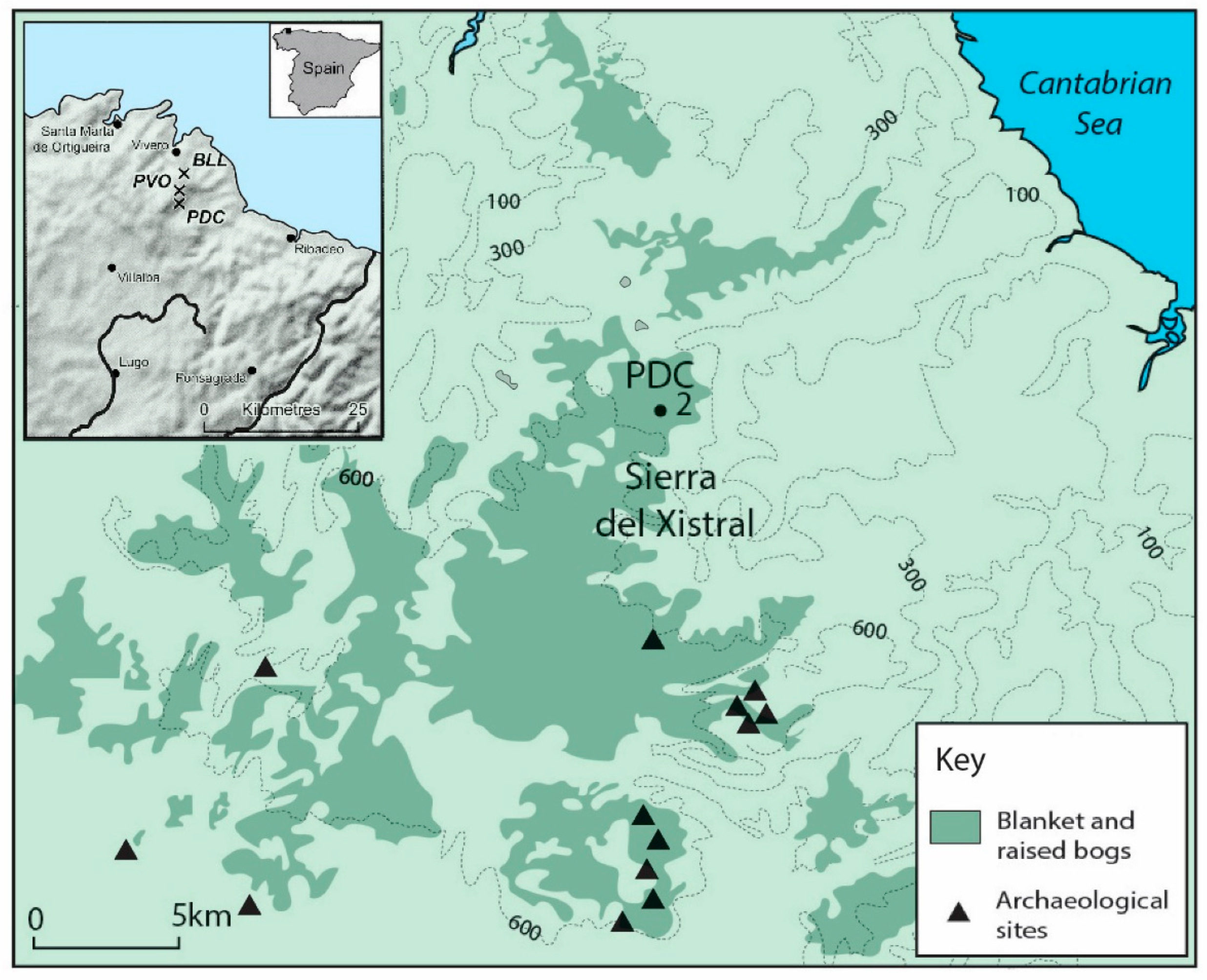
Figure 1. Location of study site (PDC2) within NW Iberia and the Galician-Asturian mountains.
Quaternary 06 00005 g001
Figure 2. Age-depth model for PDC2 peat core using CLAM software [38].
Quaternary 06 00005 g002
Figure 3. (a): Percentage pollen diagram for selected trees (dark green), shrubs (olive green), dwarf shrubs (blue), spores (light blue) and microscopic charcoal from the PDC2 peat core. (b): Percentage pollen diagram for selected herbs from the PDC2 peat core.
Quaternary 06 00005 g003
Figure 4. Percentage diagram for selected non-pollen palynomorphs from the PDC2 peat core.
Quaternary 06 00005 g004
Figure 5. Chronology of the weights (i.e., partial communalities) of the principal components extracted from the terrestrial pollen dataset of the PDC2 peat core. Scores of the taxa included in the analysis are in Supplementary Material Table S2.
Quaternary 06 00005 g005
Figure 6. Changepoints for the selected pollen taxa combined (deciduous Quercus, Corylus avellana-type, Alnus, Betula, Calluna, Poaceae and Plantago lanceolata) for PDC2 peat core. Cultural periods are included in the left-hand column, while key climatic ‘events’ are listed in the right-hand column. Numbers within the figure are in ka cal. BP.
Quaternary 06 00005 g006
Figure 7. Changepoints for the individual selected pollen taxa (deciduous Quercus [top left], Corylus avellana-type, Alnus, Betula, Calluna, Poaceae and Plantago lanceolata [bottom right]) for the PDC2 core. Green dots (actual data), grey bars (estimated errors), blue lines (represent the expected data distribution calculated by the changepoint routine) X-axes are in years ka cal. BP.
Quaternary 06 00005 g007
Figure 8. Tree-shrub-herb ratio and cereal-type (top); Microscopic charcoal; Indicators of dust deposition (Ti and Zr), Atmospheric metal pollution (Pb), Wet and dry phases (detrended peat humification values, dDPH), and selected palynomorphs (sum of Ericaceae, Erica-type and Calluna percentages; Cyperaceae percentages; HdV-18, HdV10 and HdV306) for PDC2.
Quaternary 06 00005 g008
Figure 9. Changepoints for the humification data for PDC2. Numbers within the figure are in ka cal BP. Green dots are the actual data, grey bars on the dots are the estimated errors, the blue lines represent the expected data distribution calculated by the changepoint routine.
Quaternary 06 00005 g009
Figure 10. Documented Neolithic-Bronze Age archaeological sites (white) and Iron/Roman Age Hillforts (pink) surrounding PDC mire (green). Colour areas were used when sites occupy a large area (position obtained from Información Xeográfica de Galicia, Xunta de Galicia www.xunta.gal, accessed on 25 October 2022).
Quaternary 06 00005 g010
Table 1. Bulk Radiocarbon and calibrated ages for the PDC2 peat core. Calibrated ages taken from the IntCal20 Northern Hemisphere radiocarbon age calibration curve [37].
Depth (cm)Radiocarbon Age (14C Year BP)Laboratory Code2 Sigma cal. BP
14–1550 ± 30B-307603recent
28–29440 ± 30B-307604455–530
58–591210 ± 30B-3076051060–1180
90–911720 ± 30B-3076061540–1700
126–1282080 ± 30B-3076071980–2125
158–1602890 ± 30B-3076082930–3080
186–1883470 ± 30B-3076093685–3835
220–2224320 ± 40B-3076104830–4975
266–2685120 ± 40B-3076115750–5940
308–3105880 ± 50B-3076126620–6795
336–3386090 ± 40B-3076136845–7030
358–3606640 ± 40B-3076147460–7575
380–3826890 ± 40B-3076157660–7800
402–4047180 ± 40B-3076168930–8040
Disclaimer/Publisher’s Note: The statements, opinions and data contained in all publications are solely those of the individual author(s) and contributor(s) and not of MDPI and/or the editor(s). MDPI and/or the editor(s) disclaim responsibility for any injury to people or property resulting from any ideas, methods, instructions or products referred to in the content.