Article

Multicore Study of Upper Holocene Mire Development in West-Frisia, Northern Netherlands: Ecological and Archaeological Aspects

by
Bas van Geel
1,*,
Otto Brinkkemper
2,
Guido B.A. van Reenen
1,
Nathalie N.L. Van der Putten
3,
Jasmijn E. Sybenga
1,
Carla Soonius
4,
Annemieke M. Kooijman
1,
Tom Hakbijl
5 and
William D. Gosling
1
1
Institute for Biodiversity and Ecosystem Dynamics, University of Amsterdam, Science Park 904, 1098 XH Amsterdam, The Netherlands
2
Cultural Heritage Agency of The Netherlands, P.O. Box 1600, 3800 BP Amersfoort, The Netherlands
3
Faculty of Science, Vrije Universiteit Amsterdam, De Boelelaan 1085, 1081 HV Amsterdam, The Netherlands
4
Archeologie West-Friesland, P.O. Box 603, 1620 AR Hoorn, The Netherlands
5
Naturalis Biodiversity Center, Darwinweg 2, 2333 CR Leiden, The Netherlands
*
Author to whom correspondence should be addressed.
Quaternary 2020, 3(2), 12; https://doi.org/10.3390/quat3020012
Submission received: 17 December 2019 / Revised: 11 March 2020 / Accepted: 25 April 2020 / Published: 7 May 2020
(This article belongs to the Special Issue Feature Papers in Quaternary)

Abstract

:
We studied twelve late Holocene organic deposits in West-Frisia, The Netherlands. Pollen, spores, non-pollen palynomorphs, mosses, other botanical macrofossils and insect remains were recorded for reconstructions of changing environmental conditions. Eastern West-Frisia was a cultivated landscape during the Bronze Age, but it became a freshwater wetland in the Late Bronze Age. In most of our sites, radiocarbon dates show that time transgressive inundation of soils preceded the climate shift at 850 cal BC for several centuries. We suggest that solar forcing of climate change may have delivered the final push to the inundation and depopulation of West-Frisia, which had already commenced several centuries before, due to sealevel rise. We did not find evidence for significant Bronze Age tree growth in West-Frisia before the inundations. Vegetation successions in the new wetlands developed from shallow mineral-rich freshwater to rich-fen vegetation. Subsequently poor fen vegetation with birch and pine developed, and the natural succession led to ombrotrophic raised bog vegetation. Complete successions from shallow, mineral-rich lakes to raised bog lasted between 1000 and 1500 calendar years. We hypothesize that medieval drainage and reclamation became possible only when the mires of West-Frisia had reached the raised bog stage. Reclamation of raised bogs by medieval farmers (drainage, eutrophication, peat digging) caused compaction, oxidation and loss of the upper part of the peat deposit. Seeds of salt-tolerant and salt-demanding plant species indicate that the medieval sites were inundated during storm surges with brackish or salt water, which triggered the farmers to build artificial mounds and, later, dikes. Under mounds and dikes, peat deposits remained protected against further decay. With our data we deliver a long-term perspective on contemporary ecosystem dynamics of freshwater wetlands, relevant for nature conservation and future climate change.

1. Introduction

Conservation and management of landscapes for people and nature is important for societal and ecosystem health [1]. Information on past environments, human impacts and ecosystems can provide valuable insights to inspire and guide conservation and management policies [2,3,4]. However, landscape scale information from palaeoecological systems is often lacking because the spatial density of suitable study sites is too low. The landscape in West-Frisia (Noord-Holland, The Netherlands) sits on top of a thick sequence of Holocene marine, fluvial and peat deposits [5] and has a long history of human habitation [6,7,8]. The similarity between West-Frisia and other wetland regions in North-West Europe means that findings are likely to provide insights into how climate and humans have changed landscapes and vegetation that are informative for developing management and conservation strategies. In this study we present extensive new landscape scale palaeoecological data from West-Frisia that shed new light on the nature of the past vegetation and the role of past climate change in shaping the landscape.

1.1. The Abundance of Trees in the West-Frisian Landscape during the Bronze Age

Eastern West-Frisia was inhabited by Bronze Age farmers (between ca. 1700 and 800 BC) and is now one of the best preserved and most intensively investigated Bronze Age landscapes in northwest Europe [6,7,8], however, the vegetation of the area during the Bronze Age is still a matter of discussion. The established paradigm for the vegetation suggests that the landscape of West-Frisia through the Bronze Age consisted mostly of grassland and arable fields on sandy ridges. In this model, upland trees are thought to have been virtually absent [9,10], with wetland trees like Salix and Betula only in depressions [11]. This ‘treeless landscape’ paradigm has been challenged, based on new interpretations of pollen records, wood finds and bones of mammals, to suggests that forests made up a significant part of the Bronze Age landscape in West-Frisia; with Alnus carr in wet depressions, Fraxinus-Ulmus forests at drier sites and grasslands in the relatively high and dry areas [6,12]. Furthermore, it has been suggested that, during the Bronze Age, lakes, marshy grasslands and dry arable fields alternated with patches of woodland, shrubs and even with riparian Fraxinus and Quercus forest [7]. In this study we try to find arguments pro or contra the established paradigm and the alternative ideas of van Amerongen [6,12] and van Zijverden [7]. See research question 1.

1.2. The Role of Climate Change in Driving Human and Vegetation Dynamics in West-Frisia

During the mid-Holocene (ca. 5000 BC to ca. 1500 BC) the region of West-Frisia formed part of the Bergen tidal basin. Behind an inlet near the present village of Bergen a multi-channel river system deposited sediment into tidal flats. Around 2100 BC the eastern part of the Bergen tidal basin area became disconnected from the western part [7]. The disconnection was due to a slow down in sea-level rise that allowed beach barriers and dunes to develop along the Dutch coast [5]. During the Bronze Age habitation (ca. 1700 to 800 BC) the inlet near Bergen closed around 1570 BC, increasing the area of land available to people.
Archaeological evidence indicates that towards the end of the Bronze Age (ca. 800 BC) houses were more frequently situated on creek ridges, and possibly on small artificial mounds, suggesting rising groundwater tables [8,13]. This interpretation is supported by a concomitant rise in the water table indicated by the formation of shallow freshwater lakes on top of soils that had been exposed during the Bronze Age, and the appearance of new wetlands [14,15]. This landscape change in West-Frisia is coincident with a climate event detected around the world that has become known as the 2.8 ka event [16]. A decline of solar activity around 850 cal BC (Subboreal/Subatlantic transition in raised bogs) has been suggested to have triggered an abrupt climate shift, to cooler and wetter conditions [14,15]. Around this time agricultural communities abandoned the area of West-Frisia likely due to a declining ability to produce food in an increasingly wet landscape. Evidence for this comes from the site of Enkhuizen-dijk, a shallow freshwater lake that terrestrialized and developed into a peat-forming mire, and finally to an ombrotrophic raised bog [14,15,17]. In this study we examine landscape scale palaeoecological evidence to assess if a rapid rise in groundwater occurred at a large scale across West-Frisia (research question 2).

1.3. Late Medieval Degredation of the West-Frisian Landscape

Archaeological evidence from the Iron Age and early Medieval period (ca. 800 BC to ca. AD 1000) from the wetlands of West-Frisia is almost absent, apart from settlements along the borders of Lake Wervershoof, an early Iron Age settlement site near Opperdoes [6,7], and the early medieval trade centre Medemblik [18]. About 1000 years ago, people started large-scale reclamation of the wetland areas in the western Netherlands by digging drainage ditches in the peat deposits.
Today most of the peat deposits in West-Frisia dating from the Iron Age have disappeared due to oxidation and peat digging [19]. However, some peat deposits have been found to have been preserved under subsequent medieval accumulation layers, e.g., artificial mounds [20] and dikes [17]. Access to the Iron Age peats for palaeoecological investigation has been possible during the last ten years thanks to archaeological excavations targeting the medieval deposits. It is the palaeoecological analysis of these peats that is presented here. Specifically, organic deposits from the following twelve sites are presented (Figure 1 and Table 1): Beets (BTS), Berkhout (BKH), Bovenkarspel (BVK), Enkhuizen-LangeTuinstraat (ELT), Enkhuizen-Paktuinen (EPK), Enkhuizen-Raamstraat (ERS), Enkhuizen-Vijzeltuin (EVT), Enkhuizen-Westeinde (EWE), Grootebroek-Zesstedenweg (GBZ), Oostwoud (OWD), Venhuizen-Elbaweg (VEL) and Venhuizen-Spuiter (VSP). Furthermore, the new sites are compared with two previously published palaeoecological studies of West-Frisian peat deposits, at Klokkeweel [11] and Enkhuizen-dijk [17].

1.4. Research Questions

In this palaeoecological study we focused on four research questions and assess the suitability of the landscape scale palaeoecological data from West-Frisia for informing conservation and management practice today:
(1) Is there evidence for upland forest during the late Bronze Age habitation phase in West-Frisia as suggested by van Amerongen [6,12] and van Zijverden [7]?
(2) Is there evidence for abrupt groundwater rise (start of formation of shallow lakes and mires) in eastern West-Frisia around 850 cal BC [14]?
(3) Did medieval people only drain wetlands that had developed to ombrotrophic raised bogs, because successful drainage with man-made ditches was possible in raised areas only?
(4) Are the reconstructed vegetation successions relevant for present day and future management of wetland nature and landscapes [2,3,4]?

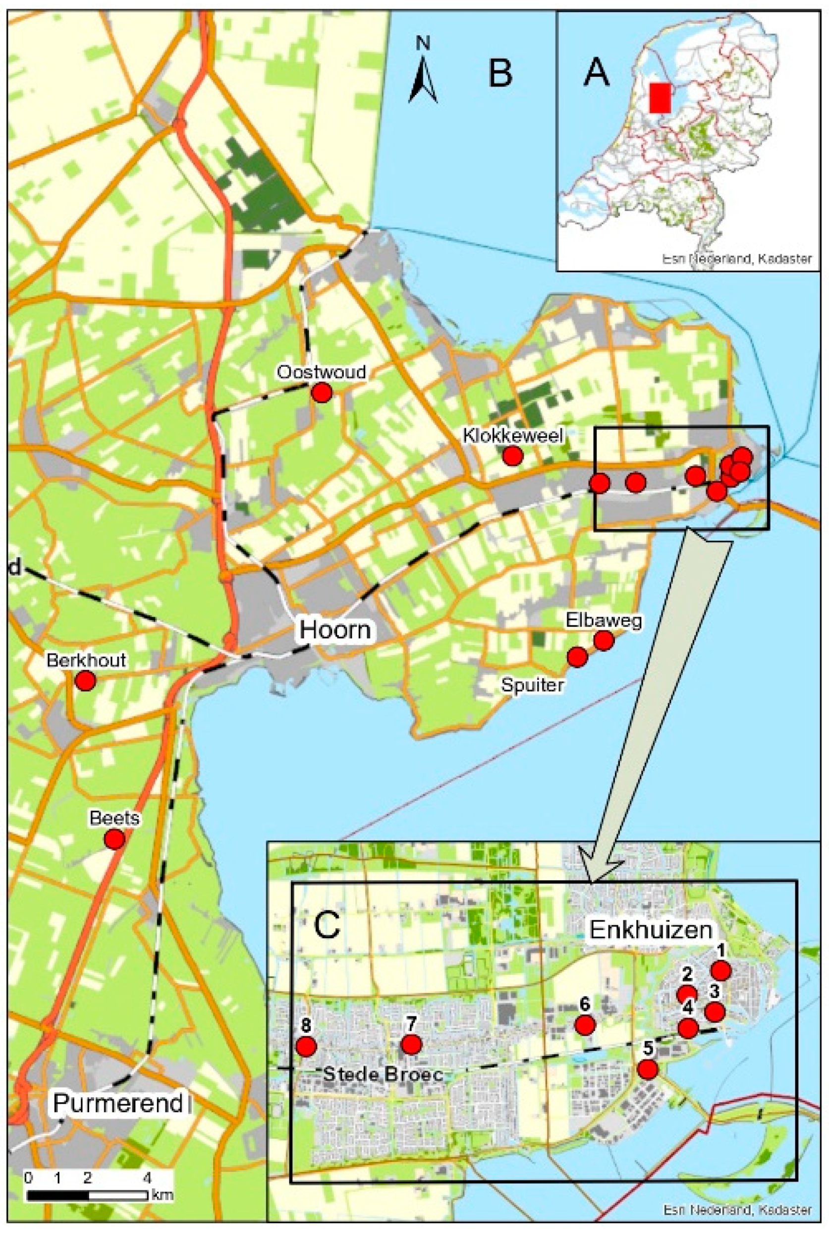
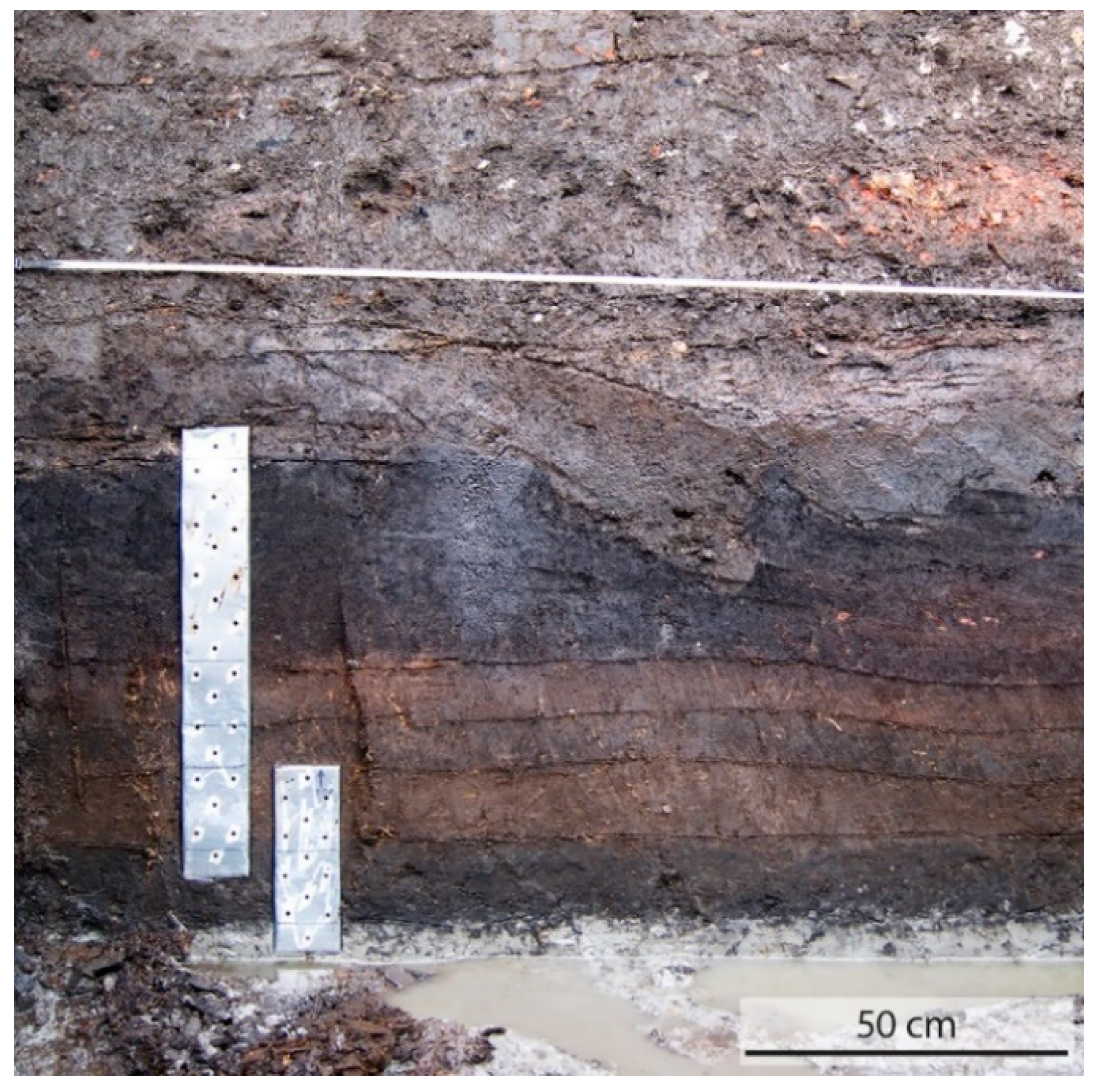
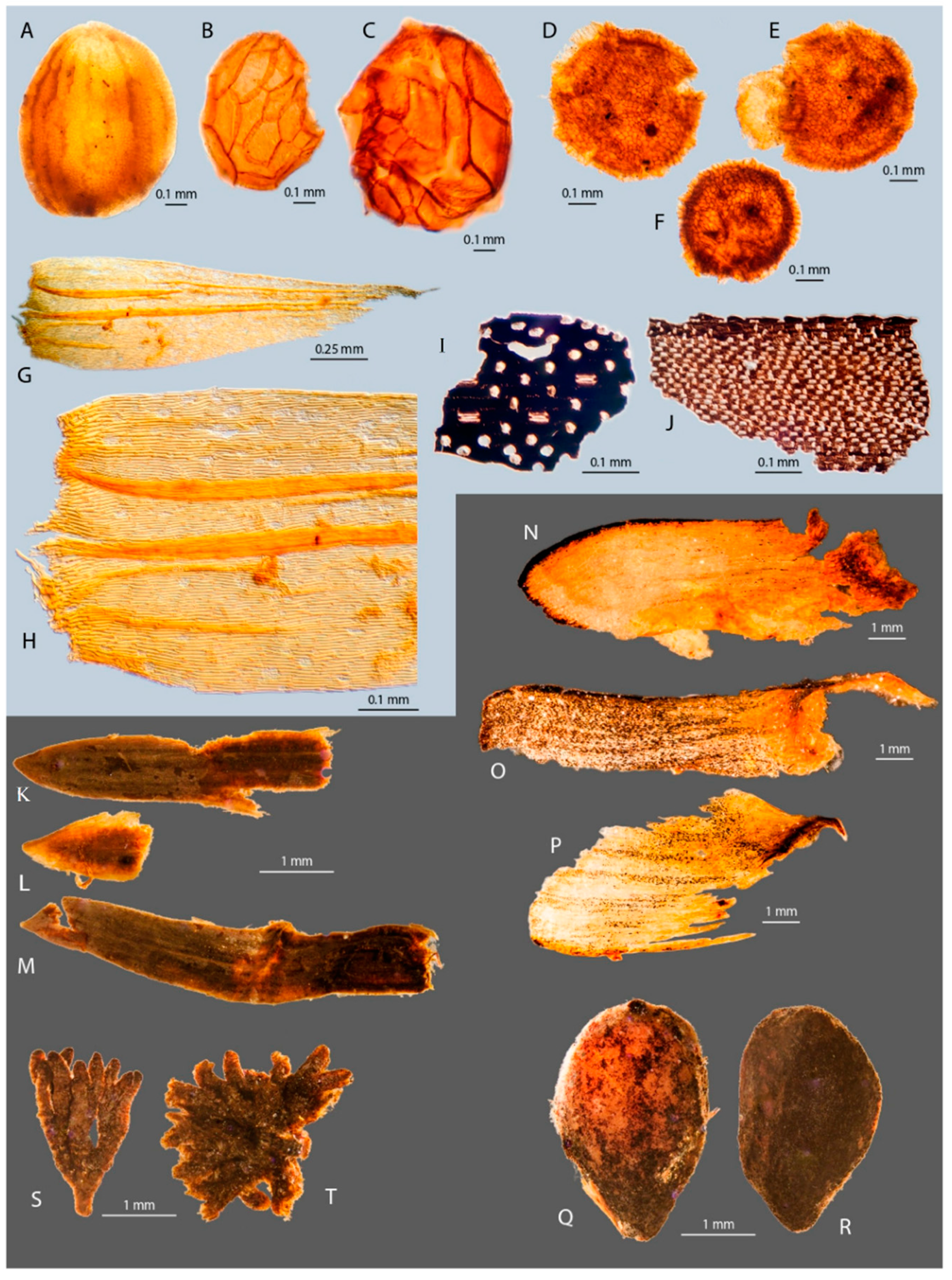
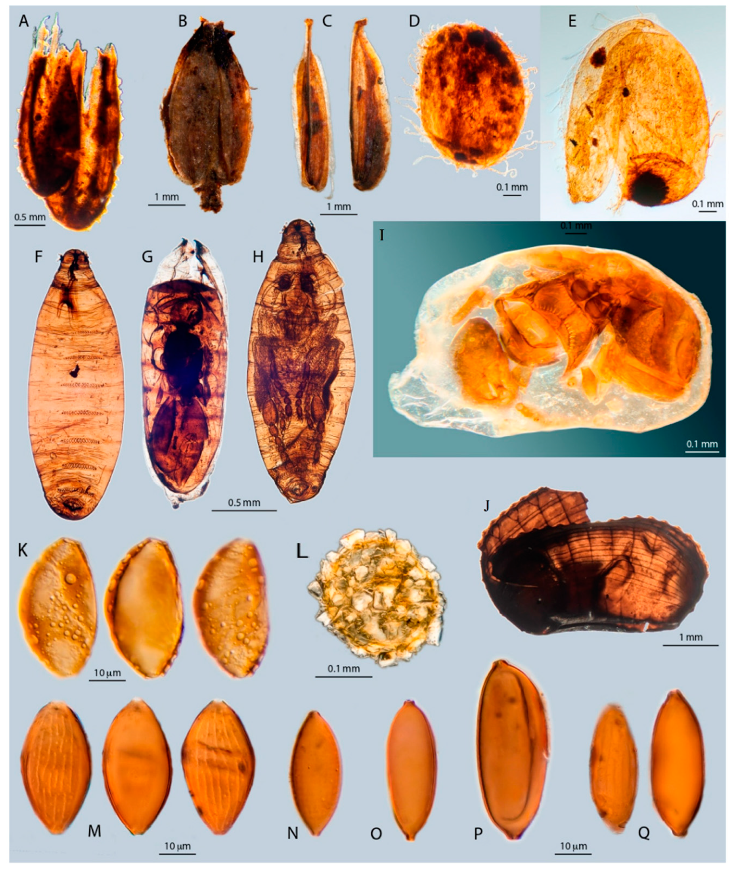
2. Materials and Methods

During archaeological excavations of medieval sites by the West-Frisian Archaeological Survey, fresh vertical cross sections were made, and metal boxes were used to sample the organic deposits (Figure 2). In most cases the samples include the transition from sandy clay (the former Bronze Age, soil surface layer), through the natural accumulation of organic material (gyttja and subsequently peat), into the layer representing the start of medieval, man-made accumulation.
Sub-samples for microfossil analysis (ca. 0.5 cc each) were taken for all sites and prepared following Faegri and Iversen [32]. The microfossils were embedded in glycerol gelatin and sealed in with paraffin wax on microscopic slides. Pollen was identified with the keys and illustrations of Moore et al. [33], Beug [34] and the pollen reference collection of IBED, University of Amsterdam. In addition to pollen grains other microfossils with a characteristic morphology (non-pollen palynomorphs or NPP) were also recorded in the pollen slides. Identification and ecological interpretation of NPP followed van Geel [35], Pals et al. [11], van Geel and Aptroot [36], and van Geel et al. [37,38,39]. See also Appendix A for additional information on the ecological indicator value of NPP.
Pollen of herbaceous swamp and aquatic taxa, fern spores and NPP are normally excluded from the sum for percentage calculations, but in the present project we focused on the strictly local vegetation successions and therefore we included, in addition to the pollen total, the fern spores and algae in the sum for percentage calculations. Diagrams were produced using the TILIA program [40]. The percentage curves in the diagrams are exaggerated ten times in light gray. Macrofossil data are shown as bars, representing counted numbers or volume-percentages as indicated below the x-axis.
Sub-samples for macrofossil analysis were taken from all sites in 1 cm thick slices from the same levels as the pollen samples. Each macrofossil sample had a volume of ca. 15 cc. The samples were treated according to Mauquoy and van Geel [41]. Fruits, seeds, other plant remains, and zoological remains were hand-picked from the residue using a stereomicroscope and the material was stored in glycerol. Most fruits and seeds were identified using the catalogue of Cappers et al. [42] and the reference collections of the University of Amsterdam and the Cultural Heritage Agency (RCE, Amersfoort). Juncus seeds and Poaceae fruits were identified with the keys and illustrations of Körber-Grohne [43,44]. In some cases, identifications of seeds or fruits were to “type-level”. Table 2 shows the possible species for those types. For identification of vegetative plant remains the reference collection of the University of Amsterdam and illustrations by Mauquoy and van Geel [41] were used. Bryophytes were identified using BLWG verspreidingsatlas [45], Landwehr [46], Nyholm [47], Siebel and During [48], Smith [49] and Touw and Rubers [50]. An exceptional case was the identification of Tomentypnum nitens. Fossil material observed in the present study did not show rhizoids on stems and leaves. Such rhizoids are an important characteristic feature of the species. However, in rare occasions T. nitens plants occur with decreasing frequency of tomentum, and plants can even be almost without rhizoids [47,51]. Macrofossils like fruits and seeds were counted, but for vegetative remains, like mosses, volume percentages in the macrofossil samples were estimated. Some of the recorded seeds, other plant remains, and some zoological remains are illustrated in Figure 3 and Figure 4.
Insect remains were studied from just two sites (EVT and EWE) due to logistical and financial constraints. The Coleoptera were identified using reference specimens from the collection of the Naturalis Biodiversity Center in Leiden. The nomenclature follows Vorst [52]. The remains of other insect groups were also identified. Each “insect” sample had a volume of ca. 15 cc and the minimum number of individuals per taxon in any one sample was mostly one, sometimes two or three. The preservation of much of the insect material was excellent. Examples are the small Sphaerocerid fly in a late stage of adult development found inside its puparium (Figure 4H), a parasitoid wasp developing inside a fly puparium (Figure 4G) and a tiny parasitoid wasp Anteris (Figure 4I) found inside an arthropod egg in which it developed. We have to await further contemporary research on the parasite and its hosts before this and some other finds can be used in palaeoecological reconstructions.
Material for radiocarbon dating was sub-sampled from above-ground material (such as seeds, leaves and bud scales). The choice for the levels to be dated was mainly based on the wish to date at least the oldest and the youngest undisturbed organic levels. There were limitations in the choices because of the availability, or absence, of above-ground materials. Twenty-nine radiocarbon dates were obtained from eleven sites (Table 3). Radiocarbon dates were calibrated using OxCAL 2019–06-09 (IntCal13; [53,54]). Graphical illustrations of the calibration results are available online as Electronic Supplementary Material (ESM Document 1). For calculation of the duration of vegetation successions the choice of the age in calendar years was made based on the highest probability.

3. Results and Interpretation

For practical reasons we only illustrate here the diagram of the site Enkhuizen-Vijzeltuin (Figure 5). For all sites the complete diagrams are available online as ESM Documents 2 and 3. Zone boundaries for each site were determined based on our ecological knowledge of the recorded taxa and on major vegetation changes. Here we present the vegetation successions at the twelve West-Frisian sites in alphabetical order. In addition to the ecological reconstructions, attention is given to chronological aspects based on radiocarbon dates, and to the duration of pre-Medieval hiatuses.

3.1. Beets (BTS, Diagram in ESM2)

During the excavation only undisturbed peat (50–9 cm depth) and the transition to the start of a human impacted peat layer were sampled. Deeper peat was not cored and therefore was not available for this study. Based on a radiocarbon date at 7 + 8 cm depth (ca. AD 300; Table 3) and the rise of Carpinus pollen we conclude that peat growth stopped in late Roman time (ca. AD 300), but it may well be that younger peat disappeared because of digging for fuel and/or by oxidation.

3.1.1. Zone BTS-1 (50–9 cm Depth)

The sampled and studied upper part of the peat deposit at Beets was formed by a raised bog with Ericales (Calluna vulgaris, Erica tetralix, Andromeda polifolia), Sphagnum sp. and specific raised bog fungi [35]: Tilletia sphagni (HdV-27), Anthostomella fuegiana (HdV-4), HdV-10, HdV-12, cf. Entophlyctis lobata (HdV-13), Meliola ellisii (HdV-14), Helicoon pluriseptatum (HdV-30), HdV-92 and HdV-9 (HdV-9 spores were illustrated by van Geel et al. [16]).
The lower 25 cm of the studied peat core was formed in relatively dry conditions (Sphagnum sect. Acutifolia, Aulacomnium palustre, Calluna vulgaris and its parasitic fungus Meliola ellisii, and HdV-10), while the upper part represents more wet local conditions (Sphagnum cuspidatum, Rhynchospora alba).

3.1.2. Zone BTS-2 (9–1 cm Depth)

The substrate is Sphagnum peat, but it is mixed with indicators for brackish or saline conditions: Armeria maritima, Juncus gerardii, Salicornia europaea, Suaeda maritima, Zannichellia palustris ssp. pedicellata, Triglochin maritima and Foraminifera, indicating marine inundations with brackish or salt water. Recorded freshwater taxa are Botryococcus, Pediastrum, Spirogyra and HdV-128A. Human impact is evident from the presence of Secale, Asteraceae liguliflorae, Brassicaceae, Plantago major/media, Rumex acetosella, Poa annua, Polygonum aviculare, Ranunculaceae, Anthoceros punctatus and spores of coprophilous fungi: Podospora, Sordaria and Sporormiella.

3.2. Berkhout (BKH, Diagram in ESM2)

The vegetation succession is not essentially different from the sites in, and near Enkhuizen, but the three radiocarbon dates (Table 3) point to relatively early starting peat growth (ca. 2550 cal BC) at the Berkhout site. The succession from the start of zone BKH-1/2 (mineral-rich shallow freshwater) to the ombrotrophic zone BKH-4 took about 1100–1300 years.

3.2.1. Zone BKH-1 (49–44 cm Depth)

Freshwater taxa are present, but to a limited extent: algal spores HdV-128A and HdV-128B, Pediastrum and Spirogyra. Neurospora ascospores (HdV-55B/C, as illustrated in Figure 4M–Q) are linked to local fire (charcoal). Cysts of marine Dinoflagellata, HdV-115 and Chenopodiaceae may be reworked from the clayey subsoil. No human impact indicators were recorded at the base of the sequence.

3.2.2. Zone BKH-2 (44–40 cm Depth)

Ranunculus subg. Batrachium, Lythrum salicaria, Ranunculus flammula, Carex rostrata, C. riparia, C. pseudocyperus, Stellaria palustris, Solanum dulcamara and Thalictrum flavum play a role in the succession from eutrophic wet-growing species towards the mesotrophic and mineral-rich fen conditions of the Thelypteris palustris phase of BKH-3.

3.2.3. Zone BKH-3 (40–4 cm Depth)

BKH-3 is a Thelypteris palustris phase of relatively long duration. Other taxa are Betula, Carex rostrata, C. acuta-type, Eriophorum vaginatum, Galium-type, Melampyrum, Menyanthes trifoliata, Pedicularis, Silene flos-cuculi, Sphagnum sp., Tomentypnum nitens, Paludella squarrosa and Calliergon giganteum. This assemblage is characteristic for mineral-rich fens with seepage of calcium and iron-rich groundwater [55].
Within zone BKH-3 we distinguish five sub-zones, based on the alternation of the bryophyte species Calliergon giganteum and Tomentypnum nitens/Paludella squarrosa:
BKH-3A (40–37 cm Depth)Mineral-rich fen with C. giganteum.
BKH-3B (37–31 cm Depth)Mineral-rich fen with T. nitens, although the raised bog fungi cf. Entophlyctis lobata (HdV-13) and HdV-65 already indicate development towards mineral-poor conditions.
BKH-3C (31–21 cm Depth)Mineral-rich fen with C. giganteum and a maximum of HdV-123.
BKH-3D (21–10 cm Depth)Mineral-rich fen with Tomentypnum nitens. HdV-13, HdV-65, Amphitrema flavum and the presence of Paludella squarrosa already point to local acidification. Paludella squarrrosa occurs in areas with a relatively high input of groundwater [56] but is especially common in mineral-poor fens.
BKH-3E (10–4 cm Depth)Mineral-rich fen with HdV-123 and C. giganteum. Some temporary disturbance (flooding with water, enriched in minerals) is evidenced by the presence of Mougeotia, Spirogyra, Zygnema-type and HdV-128A in the sample at 5 cm depth.

3.2.4. Zone BKH-4 (4–1 cm Depth)

The transition to local ombrotrophic conditions is shown by Sphagnum sp., the Sphagnum-parasite Tilletia sphagni, Ericales pollen, Andromeda polifolia, Eriophorum vaginatum and some typical raised bog microfossil taxa (Anthostomella fuegiana, HdV-12, cf. Entophlyctis lobata, Amphitrema flavum and Assulina). No human impact indicators were recorded.

3.3. Bovenkarspel (BVK, Diagram in ESM2)

No radiocarbon dates are available for the Bovenkarspel core, but based on the Fagus pollen curve we conclude that the organic sequence was formed after 800 cal BC [35].

3.3.1. Zone BVK-1 (48–41 cm Depth)

Spores of Zygnemataceae (Mougeotia, Spirogyra, Zygnema-type) indicate shallow, stagnant freshwater, with some terrestrialization. Other aquatic and semi-aquatic taxa in this zone are Botryococcus, HdV-128A, HdV-128B, Eleocharis palustris, Euphorbia palustris, Galium palustre, Lythrum salicaria, Mentha aquatica, Oenanthe aquatica and Utricularia. Possible human impact indicators are Asteraceae liguliflorae, Brassicaceae, Juncus articulatus-type and spores of Riccia (sporulation pointing to moist arable land [17]). Cysts of marine Dinoflagellata are probably reworked from the mineral subsoil.

3.3.2. Zone BVK-2 (41–35 cm Depth)

Equisetum temporarily becomes important in the vegetation succession. HdV-128A, Alisma plantago-aquatica, Cicuta virosa, Galium palustre, Lemna spec., Valeriana and Simocephalus show that wet, mineral-rich conditions still prevailed.

3.3.3. Zone BVK-3 (35–25 cm Depth)

A maximum of monolete psilate spores indicates the dominance of Thelypteris palustris in the rich-fen stage.

3.3.4. Zone BVK-4 (25–1 cm Depth)

Based on the occurrence of Sphagnum, Tilletia sphagni (parasite on Sphagnum), the raised bog fungi Anthostomella fuegiana, HdV-10, HdV-12, cf. Entophlyctis lobata (HdV-13), Meliola ellisii (parasite on Calluna vulgaris) and Eriophorum vaginatum, the local vegetation develops to a raised bog. The raised bog peat is mixed with human impact indicators and taxa that need a relatively high level of nutrients (Cerealia, Asteraceae, Brassicaceae, Atriplex patula/prostrata, Chenopodium glaucum/rubrum, Galium aparine, Polygonum aviculare-type, Persicaria maculosa-type, Ranunculaceae and Spergula arvensis). Ascospores of Podospora, Sordaria and spore cells of Sporormiella, point to the nearby availability of feces. The presence of Juncus gerardii and Triglochin maritima indicates marine inundations with brackish or salt water. Lemna spec. and Pediastrum point to freshwater conditions.

3.4. Enkhuizen-Lange Tuinstraat (ELT, Diagram in ESM2)

A radiocarbon date at 65 cm depth (Table 3) indicates the local start of aquatic organic accumulation around 1000 cal BC. The radiocarbon date at 29 cm depth shows the age of the top of undisturbed mineral-poor Betula-peat (second to third century AD). The duration of the recorded vegetation succession was ca. 1250 years.

3.4.1. Zone ELT-1 (85–63 cm Depth)

Spores of Zygnemataceae (Mougeotia, Spirogyra, Zygnema-type) indicate shallow, stagnant freshwater and HdV-128A, HdV-128B, Botryococcus, Pediastrum also point to the presence of a local aquatic habitat. Fruits and seeds of Alisma spec., Eleocharis palustris/uniglumis, Juncus articulatus-type, Lemna spec., Lythrum salicaria, Mentha aquatica, Oenanthe aquatica and Ranunculus subg. Batrachium reflect local aquatic to semi-aquatic, and relatively mineral-rich conditions. Aquatic invertebrates Lophopus crystallinus, Diaptomus castor, Moina and Simocephalus were recorded. Spores of coprophilous fungi (Apiosordaria verruculosa, Sordaria, Bombardioidea), Asteraceae, Brassicaceae and spores of Riccia may be linked to nearby farming. Ascospores of Neurospora (HdV-55B/C) are fire indicators. Dinoflagellata and Foraminifera are probably reworked from the subsoil that was deposited in marine conditions preceding the Bronze Age.

3.4.2. Zone ELT-2 (63–51 cm Depth)

This assemblage zone represents an Equisetum phase, with Carex acutiformis, C. disticha, Conium maculatum, Lycopus europaeus, Pedicularis palustris, Sparganium and Utricularia spec. The zone is further characterized by the appearance of Carex rostrata and Menyanthes trifoliata. This assemblage is indicative for mineral-rich fens. Spores of Closterium cf. rostratum, Mougeotia and Zygnema-type point to temporary presence of shallow stagnant freshwater.

3.4.3. Zone ELT-3 (51–27 cm Depth)

Thelypteris palustris (monolete psilate fern spores) is an important species, in combination with Carex rostrata, Betula spec., Galium palustre, Potentilla palustris and Silene flos-cuculi. The spectrum of taxa indicates that mineral-rich fen conditions still prevailed.

3.4.4. Zone ELT-4 (27–1 cm Depth)

This is a mixed assemblage zone of highly decomposed macrofossils. Indicators for originally ombrotrophic conditions are Sphagnum (spores), Tilletia sphagni (parasite on Sphagnum) and Polytrichum. Tomentypnum nitens at the base of the ELT-4 indicates contact with mineral-rich water. There are various indicators for inundations. The presence of Dinoflagellata, Foraminifera, Juncus gerardii, Sperularia media/salina, Triglochin maritima and the snail Hydrobia ulvae point to inundations with brackish or salt water. The presence of Botryococcus, Pediastrum, Spirogyra, HdV-128A and HdV-128B, Eleocharis palustris, Lemna spec., Ranunculus subsp. Batrachium and Moina point to inundation with fresh water, possibly due to dissolution of brackish water with rain.
Human impact is evident from the occurrence of Secale, Centaurea cyanus, Asteraceae, Brassicaceae, Chenopodiaceae, Chenopodium glaucum/rubrum, Juncus bufonius, Poa pratensis/trivialis, Polygonum aviculare, Potentilla anserina, Ranunculus repens-type, Ranunculus sceleratus and spores of Riccia.

3.5. Enkhuizen-Paktuinen (EPK, Diagram in ESM2)

A radiocarbon date at 62 + 63 cm depth (Table 3) points to an age of ca. 1050–950 cal BC for the start of the aquatic phase (zone EPK-1). The date at 18 + 19 cm depth shows that mineral-poor Betula-peat was formed until the first century AD. The duration of the recorded vegetation succession was ca. 1100 years. Evidence for later peat growth (if any) is absent because of oxidation, decomposition and mixing with medieval plant remains (Zone EPK-5).

3.5.1. Zone EPK-1 (88–69 cm Depth)

Botryococcus, Characeae, Mougeotia, Pediastrum, Spirogyra, Zygnema-type, HdV-128A and HdV-128B point to stagnant, shallow freshwater. Other (semi-)aquatic taxa are Alisma (pollen) and Alisma spec. (embryos), Euphorbia palustris, Iris pseudacorus, Lemna spec., Lycopus europaeus, Mentha aquatica, Oenanthe aquatica, Ranunculus subg. Batrachium, Ranunculus sceleratus, Sium latifolium and Veronica beccabunga-type. Recorded invertebrates are Lophopus crystallinus, and Moina. Recorded human impact indicator taxa are Asteraceae, Brassicaceae, Polygonum aviculare-type, spores of Riccia and eggs of the parasitic intestinal nematod Ascaris. Chenopodiaceae, Dinoflagellata and Foraminifera point to marine material reworked from the mineral subsoil.

3.5.2. Zone EPK-2 (69–59 cm Depth)

Equisetum is temporarily dominant. Algae are still present. Semi-aquatic taxa are Carex disticha, C. elongata, C. pseudocyperus, C. riparia, C. rostrata, Lycopus europaeus, Lythrum salicaria, Oenanthe aquatica and Ranunculus sceleratus. The cladocera Daphnia and Simocephalus were recorded. A peak of Neurospora ascospores indicates local fire.

3.5.3. Zone EPK-3 (59–30 cm Depth)

Thelypteris palustris (monolete psilate fern spores) is the dominant species, initially with Utricularia spec., Solanum dulcamara and Symphytum, and later with Betula spec., Menyanthes trifoliata, Pedicularis, Ranunculus lingua, Rumex acetosa, Silene flos-cuculi, Carex flacca/panicea and C. pseudocyperus. This points to mineral-rich fen conditions.

3.5.4. Zone EPK-4 (30–23 cm Depth)

Thelypteris shows relatively low percentages, while Betula spec. and Menyanthes trifoliata continue to be important taxa. Calliergon giganteum indicates relatively mineral-rich conditions, and point to seepage of calcium and iron-rich groundwater.

3.5.5. Zone EPK-5 (23–1 cm Depth)

The original vegetation was ombrotrophic peat with Ericales (including Calluna vulgaris), Sphagnum with its parasite Tilletia sphagni, Betula spec. and Polytrichum. Human impact and mixing of peat with younger material is evident from the increase of Cerealia pollen, the presence of Fagopyrum pollen, and Alopecurus geniculatus, Asteraceae, Atriplex patula/prostrata, Brassicaceae, Chenopodium glaucum/rubrum, Juncus bufonius, Knautia arvensis, Lycopus europaeus, Poa pratensis/trivialis, Polygonum aviculare-type, Plantago major, Rhinanthus, Rumex acetosella, Rumex maritimus, Schoenoplectus lacustris, Stellaria palustris, Urtica dioica, Riccia, spores of coprophilous fungi Podospora and Sordaria, and an egg of the intestinal parasite Ascaris. Inundation with brackish or salt water is indicated by taxa such as Chenopodiaceae, Juncus gerardii, Samolus valerandi/Centunculus minimus, Spergularia media/salina, Triglochin maritima, Dinoflagellata and Foraminifera. Freshwater indicators are the algae Botryococcus, Pediastrum, Spirogyra, HdV-128A and fruits and seeds of Eleocharis palustris/uniglumis, Hippuris vulgaris, Ranunculus subg. Batrachium, and the invertebrates Moina, Simocephalus, Lophopus crystallinus and Plumatella-type.

3.6. Enkhuizen-Raamstraat (ERS, Diagram in ESM2)

Five sampled levels in the lower part of the sequence (zones ERS-1 and ERS-2) were too poor in microfossils to show percentages. Black dots in the diagram only indicate presence of taxa. Three radiocarbon dates (90–92, 84–86 and 68–70 cm levels; Table 3) indicate that inundation with shallow freshwater started around 1300 cal BC and lasted until about 1000 cal BC. Subsequent undisturbed peat growth occurred during ca. 1200 years, until the second century AD (radiocarbon date 16–17 cm; ombrotrophic raised bog peat). Any later peat formation is not traceable because of human disturbance (drainage, oxidation and possibly peat digging).

3.6.1. Zone ERS-1 (100–73 cm Depth)

The deepest spectrum includes marine microfossils reworked from the sandy clay below the organic deposit: cysts of marine Dinoflagellata and Micrhystridium (HdV-115). The organic sequence starts with an aquatic phase. Mougeotia, Spirogyra and Zygnema-type indicate shallow stagnant freshwater. Other recorded algae are Botryococcus, Pediastrum, Characeae, HdV-128A and HdV-128B. Aquatic and semi-aquatic macrophytes in this assemblage zone are Alisma spec., Iris pseudacorus, Juncus articulatus-type, Lemna spec., Ranunculus subg. Batrachium, Sparganium and Veronica beccabunga-type. Invertebrate taxa of this aquatic phase are Daphnia, Diaptomus castor, Lophopus crystallinus, Plumatella-type and Simocephalus. Nearby human impact is evidenced by Persicaria maculosa, Polygonum aviculare, Riccia and by the spores of the coprophilous fungi Apiosordaria verruculosa, Podospora and Sordaria.

3.6.2. Zone ERS-2 (73–61 cm Depth)

A short phase with Equisetum, Carex acuta-type, C. disticha, C. rostrata, Lycopus europaeus, Lythrum salicaria, Mentha aquatica, Oenante fistulosa, Phalaris arundinacea, Ranunculus flammula and Utricularia spec. characterizes the terrestrialization towards mineral-rich fen dominated by Thelypteris of zone ERS-3. Ascospores of Neurospora indicate nearby fire.

3.6.3. Zone ERS-3 (61–29 cm Depth)

Thelypteris palustris dominates the rich-fen vegetation, initially with Carex rostrata, C. acuta-type, Lythrum salicaria, Potentilla palustris, and Utricularia. Betula spec., Menyanthes trifoliata, and Silene flos-cuculi form part of the local vegetation, indicating increasing ombrotrophy and temporary relatively dry conditions, necessary for the germination of Betula seeds.

3.6.4. Zone ERS-4 (29–7 cm Depth)

The vegetation changes to ombrotrophic conditions with Sphagnum (mainly S. palustre), Ericaceae, Eriophorum vaginatum, Pinus sylvestris, Aulacomnium palustre and raised bog fungi HdV-10, cf. Entophlyctis lobata (HdV-13) and Tilletia sphagni. The presence of Tomentypnum nitens indicates contact with mineral-rich groundwater.

3.6.5. Zone ERS-5 (7–1 cm Depth)

In the upper two samples various taxa were recorded that indicate eutrophication by inundation and human impact: Pediastrum, Foraminifera, Cerastium, Cerealia, Hydrocotyle vulgare, Juncus effusus-type, Nasturtium spec., Ranunculus sceleratus and Solanum dulcamara.

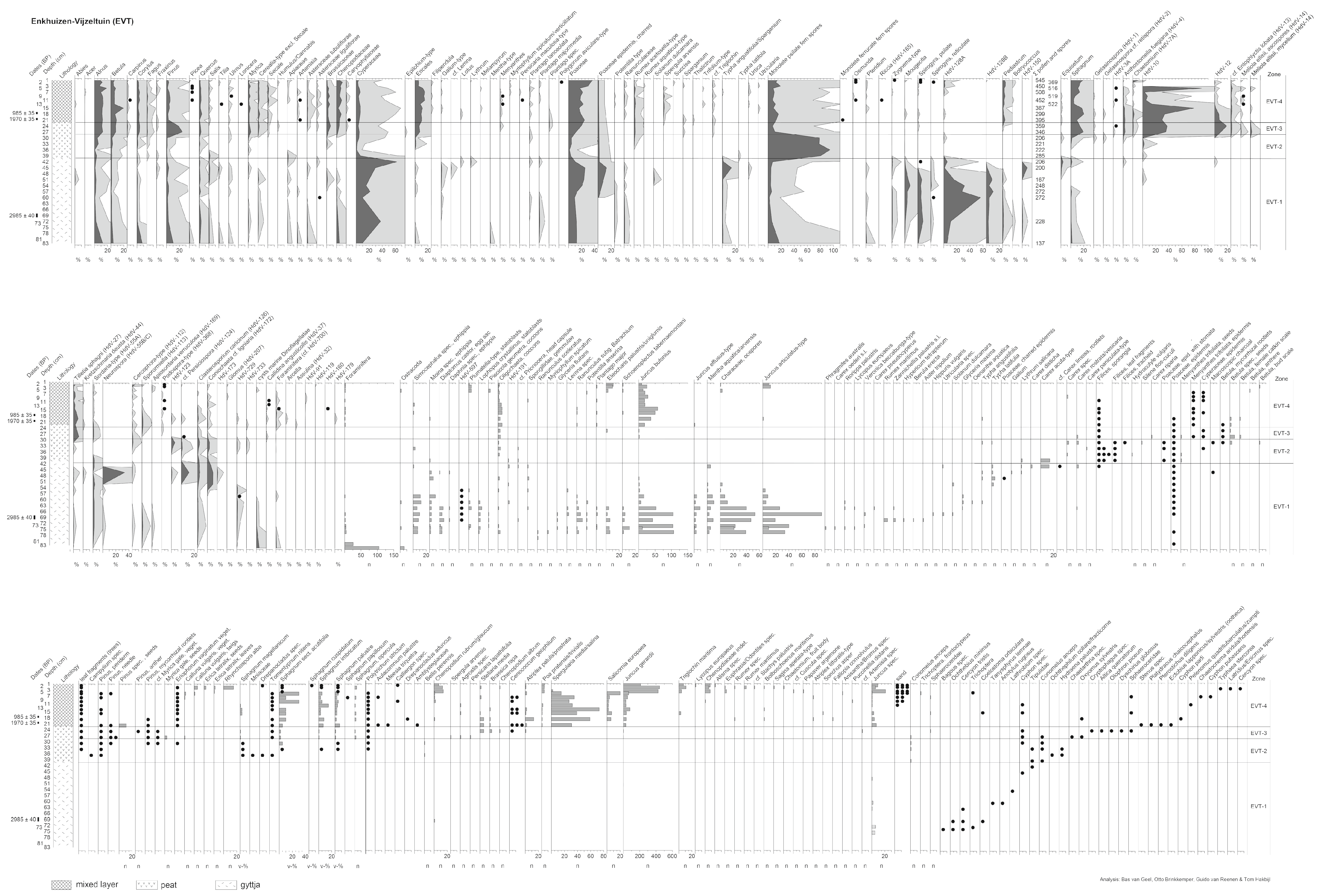
3.7. Enkhuizen-Vijzeltuin (EVT)

The radiocarbon date at 70 + 69 cm level (Table 3) indicates a rising water table (start of gyttja) around 1200 cal BC, while the dates at 21 cm (pine cone fragment) and 18 cm depth (seeds Chenopodiaceae) point to a hiatus between ca. cal AD 50 and cal AD 1050. The recorded vegetation succession from shallow open water to ombrotrophic raised bog vegetation took about 1250 years.

3.7.1. Zone EVT-1 (83–40 cm Depth)

Zygnemataceae (Mougeotia, Spirogyra, Zygnema-type) indicate shallow, stagnant freshwater. Other recorded algae are Botryococcus, Characeae, Pediastrum, HdV-128A and HdV-128B. In addition, we found (semi-)aquatic taxa: Berula erecta, Carex oederi, Carex pseudocyperus, Eleocharis palustris/uniglumis, Glyceria fluitans, Glyceria maxima, Hippuris vulgaris, Hypericum tetrapterum, J. articulatus-type, Lemna spec. (with its phytofage weevil Tanysphyrus lemnae), Lycopus europaeus, Lythrum salicaria, Mentha aquatic/arvensis, Myriophyllum spicatum, Oenanthe aquatica, Potentilla anserina, Phragmites australis, Ranunculus subg. Batrachium, Ranunculus sceleratus, Rorippa palustris, Rumex maritimus, Schoenoplectus tabernaemontani, Solanum dulcamara, Typha angustifolia, Typha latifolia, Utricularia spec., Veronica beccabunga-type and Zannichellia palustris. Bagous feeds on water and marsh plants. The beetles Cercyon tristis, Ochthebius minimus, Coelostoma orbiculare and larval Trichoptera live in shallow water, together with the other invertebrates: Simocephalus, Moina, Diaptomus castor, Plumatella-type, Lophopus crystallinus and Piscicola geometra. Equisetum, Lythrum salicaria and Carex acuta-type occur at the transition to EVT-2. HdV-597 (Figure 4L) is a newly recorded globose “macrofossil”. Its wall is covered with small mineral particles. It was also observed (but not counted) in the gyttja phase of other West-Frisian sites.
Human impact indicators (in a broad sense) recorded in zone EVT-1 are Plantago major, Juncus bufonius, Sordaria, Sporormiella, Apiosordaria verruculosa and Podospora. Dinoflagellata and Foraminifera probably represent reworked marine subsoil.
In the lower half of this zone the macroscopic parts of aquatic invertebrates are common, but in the upper half of EVT-1 these organisms diminish or disappear, indicating terrestrialization that is also reflected by a decline of Ranunculus subg. Batrachium and Characeae, the appearance of Typha latifolia and T. angustifolia and the occurrence of charcoal and fungal spores of the fire indicator Neurospora.

3.7.2. Zone EVT-2 (40–28 cm Depth)

Thelypteris palustris (monolete psilate fern spores) plays a role in the vegetation succession with Carex rostrata, Hydrocotyle vulgaris, Menyanthes trifoliata, Silene flos-cuculi, Sphagnum sp., Polytrichum strictum, Campylium, Drepanocladus and Tomentypnum nitens. This species assemblage points to mineral-rich fen. Betula and Pinus start to occur on the fen surface.

3.7.3. Zone EVT-3 (28–22 cm Depth)

Pinus pollen shows a maximum and various pine macrofossil (Figure 3K–T) indicate local occurrence at the sampling site. Betula spec., Myrica gale, Tomentypnum nitens, Meesia triquetra and Eriophorum vaginatum occur and Ericales and Sphagna show an increase, which points to development of mineral-poor fen. Raised bog fungi HdV-10, HdV-12, cf. Entophlyctis lobata (HdV-13), and Meliola ellisii (HdV-14) are present. The rotifer Callidina angusticollis (HdV-37) is also an indicator of mineral-poor conditions. In EVT-3 there is the first appearance of Secale and other human impact indicators show a rise: Asteraceae, Brassicaceae, Chenopodiaceae, Caryophyllaceae, Rumex acetosella-type and spores of the coprophilous fungi Podospora and Sordaria. The beetle Altica quercetorum may indicate the nearby presence of Quercus, possibly in its juvenile state.

3.7.4. Zone EVT-4 (22–1 cm Depth)

In addition to the raised bog taxa mentioned for EVT-3, we recorded Pediastrum, Myriophyllum spicatum/verticillatum, Utricularia, Piscicola geometra, Tomentypnum nitens and Meesia triquetra, which point to more mineral-rich conditions. In addition, Bolboschoenus maritimus, Foraminifera, Juncus gerardii, Puccinellia distans, Spergularia media/salina, Salicornia europaea, Triglochin maritima, Atriplex littoralis-type and Dinoflagellata indicate inundation with brackish or salt water. The beetles Pelenomus quadrituberculatus/zumpti are halotolerant. Various human impact indicators (sensu lato) appear: Agrostis, Asteraceae, Atriplex patula/rostrata, Brassicaceae (pollen), Brassica rapa, Caryophyllaceae, Chenopodiaceae (pollen), Chenopodium album, Chenopodium rubrum/glaucum, Euphrasia/Odontites spec., Fallopia convolvulus, Juncus bufonius, Papaver argemone, Plantago major, Poa pratensis/trivialis, Riccia, Sagina apetala/procumbens, Sonchus asper, Spergula arvensis and Stellaria media. Puparia of Sphaeroceridae (Figure 4F–H) were observed. They commonly occur in organic refuse such as feces [57]. In the top of EVT-4 the beetle Typhaea stercorea was recorded. Nowadays it is often found in barns with stored products, together with Latridus/Enicmus.
The find of a subfossil egg capsule of the cockroach Ectobius (Figure 4J) in the sample at 21 cm depth is noteworthy. These only accidentally house-dwelling cockroaches currently do not occur in the lower parts of the Netherlands. The recent distribution of Ectobius spp. in the Netherlands is restricted to the Pleistocene and coastal sand dune landscapes, now the only areas with low nutrition levels and open vegetation types. At the site Vijzeltuin (EVT) Ectobius lived on the raised bog, in the open pine forest, which it prefers (pine seeds and other pine macrofossils present in the same sample).

3.8. Enkhuizen-Westeinde (EWE, Diagram in ESM3)

The radiocarbon dates at 37 and 25 + 26 cm depth (Table 3) point to inundation of the site around 900–850 cal BC. The date at 13 cm depth corresponds to the Hallstatt plateau in the calibration curve [58] and therefore it represents a very long period (ca. 350 years of uncertainty between ca. 740 and 410 cal BC) on the calendar time axis. The period of the last ca. 2500 years is not represented as undisturbed peat.

3.8.1. Zone EWE-1 (46–26 cm Depth)

Zygnema-type, Spirogyra, and Mougeotia point to shallow, stagnant freshwater. Apart from those filamentous algae Pediastrum, Rivularia-type (HdV-184; cyanobacteria) HdV-128A and HdV-128B also occur. Alisma lanceolatum/plantago-aquatica, Callitriche spec., Glyceria fluitans, Hottonia palustris (Figure 3B,C), Iris pseudacorus, Lythrum salicaria, Mentha aquatica, Ranunculus sceleratus, Rorippa palustris, Ranunculus subgenus Batrachium, Sparganium, Stachys palustris, Oenanthe aquatica, Utricularia spec. and Veronica beccabunga-type all point to a local aquatic to a semi-aquatic nutrient and mineral-rich environment. In the upper part of EWE-1 seeds of Sium latifolium and Stellaria palustris were recorded.
Local zoological aquatic taxa in zone EWE-1 are Cladocera (Daphnia, Moina, Simocephalus), Bryozoa (Lophopus crystallinus, Plumatella-type), Diaptomus castor and Porifera.
The insects Ochthebius spec, Coelostoma orbiculare, Tanysphyrus lemnae, Hydroporus and Trichoptera larvae also point to shallow water and Donacia semicuprea lives on Glyceria and Sparganium. Several ascospore types of coprophilous fungi in EWE-1 indicate a nearby presence of feces as a substrate: Apiosordaria verruculosa, Bombardioidea-type, Cercophora, Podospora, Sordaria and Sporormiella. Neurospora spores (HdV-55B/C) indicate nearby fires, and Riccia spores indicate moist arable land [17]. During the excavation parcellation ditches were observed below the peat deposit. The cysts of Dinoflagellata may be reworked (bioturbation) from the clayey, silty subsoil that was deposited before the Bronze Age habitation.

3.8.2. Zone EWE-2 (26–20 cm Depth)

The taxa at the start of this zone (Cicuta virosa, Epilobium palustre, Lycopus europaeus, Lythrum salicaria, Ranunculus flammula, Salix and Solanum dulcamara) still point to nutrient and mineral-rich local moist conditions. The beetles Hydraena, Noterus crassicornis and Hydroporus point to the presence of water, Gyrinus aeratus to sufficient surface water, Limnobaris dolorosa to the presence of Cyperaceae and Plateumaris bracata to Phragmites australis.
An important role in the terrestrialization of the site is played by Equisetum (most probably E. fluviatile). A declining nutrient level is indicated by Menyanthes trifoliata, and the occurrence of Carex pseudocyperus, C. riparia, Pedicularis palustris and Potentilla palustris, which point to mesotrophic mineral-rich fens. HdV-598 is a newly recorded microfossil that occurs in this zone. It is still unidentified and has a characteristic form and wall sculpture (Figure 4K).

3.8.3. Zone EWE-3 (20–13 cm Depth)

The vegetation succession is taken over by Thelyptris palustris (monolete psilate fern spores and sporangia). Galium-type (probably G. palustris), Menyanthes, Rumex acetosa-type, Silene flos-cuculi and finally Betula spec. seeds, coinciding with a maximum in Betula pollen, all fit in the picture of a further decline of mineral richness. Betulapion simile feeds on Betula, while Sialis, Cyphon and Laccobius indicate the nearby presence of open water.

3.8.4. Zone EWE-4 (13–3 cm Depth)

The transition from EWE-3 to EWE-4 shows a decline of fern spores, and a sudden increase of Sphagnum, its parasite Tilletia sphagni, and Ericales, together reflecting ombrotrophic bog conditions. However, there is no undisturbed bog deposit present at the site, because the samples show a mix of ombrotrophic taxa, Pediastrum and HdV-128A (both occur in relatively nutrient-rich freshwater) and Foraminifera, the marine mollusk Littorina and Triglochin (salt or brackish conditions; probably as a consequence of marine inundations). Secale and some other taxa (e.g., Asteraceae, Brassicaceae, Chenopodiaceae) reflect nearby human impact on former raised bog deposits. Some ascospores of the dung-inhabiting Sordaria and Podospora were recorded.

3.9. Grootebroek-Zesstedenweg (GBZ, Diagram in ESM3)

The radiocarbon date at 96 + 97 cm (Table 3) points to a rising water table and inundation around 1000 cal BC. The dated level at 48 + 49 cm depth shows that the vegetation succession until the ombrotrophic stage took about 1000 years. There is no undisturbed peat deposit at the GBZ-site for the last ca. 2000 years.

3.9.1. Zone GBZ-1 (113–95 cm Depth)

Zygnemataceae (Mougeotia, Spirogyra, Zygnema-type) indicate shallow, stagnant freshwater. Other algae of the aquatic phase are Botryococcus and HdV-128A and HdV-128B. The zone is further characterized by various (semi-)aquatic taxa of mineral-rich conditions: Alisma spec., Bidens tripartita, Carex riparia, Characeae, Eleocharis palustris/uniglumis, Glyceria fluitans, Hottonia palustris, Lemna spec., Lycopus europaeus, Mentha aquatica, Oenanthe aquatica, Ranunculus subg. Batrachium, Solanum dulcamara, Sparganium, Stachys palustris, Typha, Utricularia spec., Valeriana and Veronica beccabunga-type. Daphnia, Diaptomus castor, Lophopus crystallinus, Moina and Simocephalus, are the recorded faunal taxa, while Dinoflagellata and Foraminifera were probably reworked from the underlying marine sediments that were deposited before the Bronze Age habitation. The ascospores of the coprophilous fungi Podospora, Cercophora, Sporormiella and Apiosordaria verruculosa indicate feces as a substrate.

3.9.2. Zone GBZ-2 (95–75 cm Depth)

GBZ-2 is a rich-fen phase with a dominance of Thelypteris palustris; initially with Carex cf. aquatilis. Other taxa occurring in this zone are Conium maculatum, Lythrum salicaria and Euphorbia (probably E. palustris).

3.9.3. Zone GBZ-3 (75–49 cm Depth; the Interval between 65 and 49 cm Depth Was not Sampled)

Temporarily the filamentous algae return (Mougeotia, Spirogyra, Zygnema-type) in combination with HdV-128A. Seeds of Carex rostrata/vesicaria, C. pseudocyperus, Epilobium palustre and Menyanthes trifoliata were recorded. Macro-remains of Betula spec. point to the local occurrence of birches on the mire surface. Meesia triquetra and Calliergon giganteum still point to mineral-rich conditions.

3.9.4. Zone GBZ-4 (49–39 cm Depth)

Apart from birch, Pinus sylvestris becomes locally present, indicating oligotrophication and relatively dry conditions of the mire surface at the sampling site. Sphagnum palustre, S. sect. Acutifolia, S. imbricatum, Assulina and Callidina angusticollis appear, pointing to a transition to ombrotrophic raised bog conditions. Ericales pollen starts to increase, but samples 45 and 41 already show some admixture with several taxa that do not grow in an undisturbed raised bog: Atriplex patula/prostrata, J. bufonius, J. gerardii, Potentilla anserina, Ranunculus sceleratus and Spergularia media/salina. Spores of Sordaria, Podospora and Sporormiella are present; these coprophilous fungi would not appear in undisturbed raised bog deposits.

3.9.5. Zone GBZ-5 (39–1 cm Depth)

Many recorded taxa, such as Sphagna, Aulacomnium palustre, Polytrichum strictum, Pohlia nutans, Calluna vulgaris, Eriophorum vaginatum and Oxycoccus palustris indicate raised bog conditions. Various fungal taxa are well known from raised bog deposits [35]: Anthostomella fuegiana, HdV-10, HdV-12, cf. Entophlyctis lobata, Meliola ellisii (parasitic on Calluna vulgaris), Tilletia sphagni, and Helicoon pluriseptatum. The invertebrate taxa Amphitrema flavum, Assulina and Callidina angusticollis also form part of the raised bog ecosystem.
The substrate of GBZ-5 is raised bog peat, but it appears to be disturbed, which is reflected by the recorded taxa of relatively nutrient-rich conditions: Anthriscus caucalis, Atriplex patula/prostrata, Chenopodium glaucum/rubrum, Hydrocotyle vulgaris, Juncus bufonius, Persicaria lapathifolia, Polygonum aviculare, Ranunculus sceleratus, Rumex acetosella, Rumex hydrolapathum, Sonchus asper, Stellaria media and Urtica urens. Salt-tolerant taxa were recorded: Bolboschoenus maritimus, Juncus gerardii, Triglochin maritima and Foraminifera, which point to inundation with brackish or salt water.
Nearby human impact is reflected by several pollen taxa: Secale, increased Brassicaceae, Caryophyllaceae, Chenopodiaceae, Persicaria maculosa-type and Linum usitatissimum. We cannot exclude that GBZ-5 already represents the basal layer (12th/13th century AD) of the man-made mound.

3.10. Oostwoud (OWD, Diagram in ESM3)

The radiocarbon dates at 68 and 61 cm level (Table 3) show that the start of the deposition of gyttja and subsequent peat growth at the Oostwoud site occurred around 1650 cal BC. The date at 29 cm shows that the peat deposit is undisturbed only until around 750 to 550 cal BC (Hallstatt plateau in the radiocarbon calibration curve [58]).

3.10.1. Zone OWD-1 (86–66 cm Depth)

From 86 to 66 cm depth some macrofossils were recorded in the sandy clay, but the concentration of microfossils was too low, and the preservation was too bad for reliable quantification. Seeds of Juncus effusus-type, J. articulatus-type, J. bufonius, Carex riparia, Chenopodium polyspermum, Potentilla spec., Rumex spec. and Solanum nigrum were preserved in the sandy substrate. In the upper part of OWD-1 Carex otrubae/vulpina, Hypericum tetrapterum, Mentha aquatica/arvensis and Urtica dioica occur.

3.10.2. Zone OWD-2 (66–60 cm Depth)

This zone represents the transition from soil to peat-forming wetland vegetation with Eupatorium cannabinum, Lycopus europaeus, Lythrum salicaria, Typha angustifolia, T. latifolia and the algae Spirogyra, HdV-128A and HdV-128B.
In OWD-2 and at the transition to OWD-3, Ranunculus lingua, Ranunculus subg. Batrachium, Carex rostrata, C. pseudocyperus, C. disticha, Menyanthes trifoliata, Pedicularis palustris, Sium latifolium, Stellaria aquatica, S. palustris and the bryophytes cf. Amblystegium and cf. Drepanocladus occur, with aquatic invertebrates Trichoptera, Lophopus crystallinus and Simocephalus. Spores of Riccia may indicate damp arable land, while Sporormiella and Sordaria need feces as a substrate. Neurospora ascospores are stratigraphically and ecologically linked with macroscopic charcoal (diagram in ESM-3). Dinoflagellata and Foraminifera probably represent some bioturbation from the marine subsoil.

3.10.3. Zone OWD-3 (60–51 cm Depth)

Thelypteris palustris becomes a dominant species and it is growing together with Lotus, Lythrum salicaria, Menyanthes trifoliata, Pedicularis, Potentilla-type, Carex rostrata and C. acuta-type, which point to mineral-rich fen. The presence of Mougeotia spores shows that temporary shallow stagnant freshwater still prevailed, probably in springtime when the spores were formed.

3.10.4. Zone OWD-4 (51–27 cm Depth)

This zone shows high proportions of Thelypteris palustris, with Betula, Carex rostrata, Epilobium palustre, Menyanthes trifoliata, Pedicularis (probably P. palustris), Rumex acetosella-type (probably R. acetosa), Silene flos-cuculi and Calliergon cf. giganteum, which still point to mineral-rich fen. Spores of Mougeotia indicate temporary shallow, stagnant water. Spores of the desmids Closterium idiosporum and C. cf. rostratum mark the transition to the ombrotrophic conditions of OWD-5.

3.10.5. Zone OWD-5 (27–22 cm Depth)

Ericales (among which Erica tetralix), Eriophorum vaginatum, Aulacomnium palustre, Polytrichum, Sphagnum imbricatum and fungi known from ombrotrophic raised bogs (Anthostomella fuegiana, HdV-10, HdV-12, cf. Entophlyctis lobata, Meliola ellisii, Tilletia sphagni) form part of the original ombrotrophic vegetation.
The peaty substrate is mixed with indicators for nutrient and mineral-rich conditions and human impact indicators: Cerealia, Atriplex patula/prostrata, Cerastium spec., Chenopodiaceae, Chenopodium glaucum/rubrum, Glyceria fluitans, Juncus bufonius, Persicaria maculosa-type, Poa pratensis/trivialis, Ranunculus sceleratus, Stellaria media and Sporormiella, while Pediastrum, and Plumatella-type indicate relatively nutrient and mineral-rich freshwater. Spergularia media/salina, Juncus gerardii and Foraminifera point to inundations with brackish or salt water.

3.11. Venhuizen-Elbaweg (VEL) and Venhuizen-Spuiter (VSP)

During excavations at the sites Elbaweg and Spuiter, profiles of the “Westfriese Omringdijk” (Late Medieval dike for protection against the sea) were made and a compacted, ca. 15 thick peat layer, below the oldest, medieval layer of the dike was sampled at both sites, including the layers below and above the peat layer. The sampled sediments below the peat layer consisted of sandy clay, and therefore the microfossil contents have a predominantly allochthonous, marine origin, mixed with pollen of upland taxa. The peat layers (zones VEL-2 and VSP-2) were formed by local peat-forming plants. The sampled sediments deposited on top of the peat had been collected and transported to the sampling site as sods by late Medieval people when constructing the first dike. That dike-material was also built up of sandy clay, but without an orderly stratigraphy. At the site Elbaweg a second, ca. 3 cm thick horizontal organic layer, situated about 35 cm above the peat layer, showed a stagnation phase in the history of dike building (see below, assemblage zone VEL-4).

3.12. Venhuizen-Elbaweg (VEL, Diagram in ESM3)

The two radiocarbon dates (Table 3) at the base (68–70 cm depth) and the top (53–54 cm depth) of the peat layer show that peat growth (zone VEL-2) started between ca. 750 and 450 cal BC and continued to accumulate until about 400 cal AD.

3.12.1. Zone VEL-1 (99–74 cm Depth)

The sediment (sandy clay) of this zone is characterized by microfossils indicating marine conditions (relatively high percentages of Chenopodiaceae and Dinoflagellata) and freshwater algae (Pediastrum, Botryococcus, Mougeotia, Spirogyra, other Zygnemataceae and HdV-128A).

3.12.2. Zone VEL-2 (74–52 cm Depth)

A peak of Salix pollen at the base of the peat deposit represents the first local carr vegetation, followed by high percentages of Alnus pollen. Willow and alder represent local wet, nutrient-rich conditions. Oenanthe aquatica, Urtica dioica, Lemna spec. (seeds and pollen) and the aquatic invertebrates Lophopus crystallinus and Simocephalus were also recorded in the peat layer. The upper few centimeters of the peat layer show a peak of Betula that indicates a decline of available nutrients, due to isolation from the mineral soil.

3.12.3. Zone VEL-3 (52–19 cm Depth)

The mineral sediments on top of the peat show some freshwater algae, Chenopodiaceae (Chenopodium glaucum/rubrum; Atriplex patula/prostrata), Foraminifera, Juncus gerardii and human impact indicators (sensu lato) like J. bufonius, J. effusus-type, Ranunculus sceleratus and Stellaria media.

3.12.4. Zone VEL-4 (19–16 cm Depth)

The thin organic layer of VEL-4 shows a peak in Poaceae (together with fruits of Phragmites australis), Plantago major and a considerable number of spores of coprophilous fungi: Sordaria, Sporormiella, Cercophora, Apiosordaria verruculosa and Podospora. We suppose that VEL-4 represents a stagnation phase in dike accumulation, while the large number of spores of coprophilous fungi shows that the first, low dike was grazed by herbivores.

3.12.5. Zone VEL-5 (16–5 cm Depth)

The spectra of microfossils and macro-remains have much in common with zone VEL-3.

3.13. Venhuizen-Spuiter (VSP, Diagram in ESM3)

The radiocarbon date at the base of the peat layer (Table 3) shows that peat growth started, like at the site Elbaweg, between ca. 750 and 450 cal BC. Plant remains from a small filled up depression (ditch) that disturbed the peat layer of zone VSP-2, were dated around 500 cal AD.

3.13.1. Zone VSP-1 (43–30 cm Depth)

The sandy clay sediment of this zone is characterized by microfossils indicating marine conditions (relatively high percentages of Chenopodiaceae and Dinoflagellata) and freshwater algae (Pediastrum, HdV-128A and HdV-128B).

3.13.2. Zone VSP-2 (30–21 cm Depth)

This zone represents the peat layer. Alnus shows relatively high percentages, indicating that the peat was formed by an alder carr, with local Apiaceae, Potamogeton/Triglochin and ferns.

3.13.3. Zone VSP-3 (21–1 cm Depth)

The sediments on top of the peat show freshwater algae (Botryococcus, Characeae, Pediastrum, Spirogyra, and HdV-128A and HdV-128B and Hippuris vulgaris), but also salt-tolerant and marine taxa (Juncus gerardii, Foraminifera, cysts of marine Dinoflagellata and Chenopodiaceae).

4. Discussion

4.1. Forest in West-Frisia during Late Bronze Age? (Research Question 1)

Van Amerongen [6,12] challenged the paradigm of an almost treeless landscape in West-Frisia during the Bronze Age. She suggested that there may have been a considerable forest cover: Alnus carrs in wetlands, Fraxinus-Ulmus forests at drier sites and grasslands in the relatively high and dry areas. In addition, van Zijverden [7] supposed that lakes, marshy grasslands and dry arable fields alternated with patches of woodland, shrubs and even with riparian Fraxinus and Quercus forest.
If forest would have been present during the late Bronze Age, then one could expect evidence for drowned forest at our sites. Local forest would have been reflected by high tree pollen percentages and we would expect clumps of tree pollen [59] that we did not observe. We also would expect arboreal fruits/seeds, and tree roots in the upper soil just below the shallow lake sediment that we found at most of the sites. We did not find such evidence. In other words: our samples representing the Late Bronze Age do not point towards a forested landscape, apart from willow and birch carr around the freshwater lake Klokkeweel [11].
We suppose that people with their domesticated herbivores will have hampered the immigration of tree species because of grazing pressure starting after the marine phase at the moment that the area became habitable for plants, for people and for domesticated and wild herbivores. We have no evidence for local tree growth on dry soils before the recorded rise of the groundwater and therefore we do not accept the hypothesis of van Amerongen [6,12] and van Zijverden [7] about forested areas in West-Frisia during the Bronze Age.

4.2. Rise of Groundwater and Climate Change (Research Question 2)

Van Amerongen [6] and van Zijverden [7] argued against the hypothesis that abrupt climate change and the consequent sudden rise of the groundwater table caused the depopulation at the end of the Bronze Age in eastern West-Frisia [14,15]. The hypothesis was mainly based on the radiocarbon dated site Enkhuizen-dijk and on the youngest archaeological Bronze Age dates of West-Frisia, and a link was made with the transition in raised bogs, elsewhere in The Netherlands, from “Older Sphagnum peat” to “Younger Sphagnum peat” at the start of a steep rise of ∆14C around 850 cal BC (2.8 event). Martin-Puertas et al. [60] and van Geel et al. [16] found strong additional evidence for a link between a steep rise of ∆14C starting around 850 cal BC and abrupt climate change to cooler and wetter conditions. The present study shows that inundation of most of our sites in eastern West-Frisia (ELT, EPK, ERS, EVT, GBZ; all in the Enkhuizen area) already started centuries before 850 cal BC, i.e., between 1300 and 1000 cal BC (Figure 6). A gradually rising sealevel apparently caused a rise in ground water [61], and the amount of shallow pools to increase. This hydrological change finally made eastern West-Frisia inhabitable around 800 cal BC. A short-term climate-related rise in ground water at 850 cal BC may have occurred; however, it seems that this was super imposed on a longer-term rise in ground water indicated by the process of paludification that had already been going on for several centuries. The hypothesis suggesting that solar forcing caused abrupt climate change around cal 850 BC is therefore not clearly tested with these data, because the impact of this event may, or may not, have been overridden by ongoing sealevel rise. However, we observe that by cal 850 BC all study sites contain sediments indicative of shallow lake environments, suggesting that by this time the transition to wetlands across West-Frisia may have been given final impetus by the climatic shift. The first freshwater inundations of the sites Berkhout and Oostwoud are much earlier (respectively ca. 2550 cal BC and ca. 1650 cal BC) but those sites are relatively far away from the sites in and near Enkhuizen.

4.3. Medieval Start of Peat Land Reclamation and Settlements (Research Question 3)

Based on archaeological evidence in the Netherlands, Heidinga [62] supposed that the trigger for medieval reclamation of wetlands in the western Netherlands was a dry 10th century AD, and therefore population density pressure in the areas of sandy soils. Wetlands were available for reclamation, but we emphasize that not all wetlands on top of peat deposits could be sufficiently drained to allow reclamation. The suitability for artificial drainage and reclamation was determined by the water table position and the vegetation type. In wetland vegetation successions we often see a trend starting with plant species that require contact with the mineral subsoil that moves towards species that prefer mineral-poor conditions. During the vegetation succession the peat deposit increased in thickness and the roots lost contact with the mineral subsoil and the peat-forming vegetation became more and more dependent on rainwater.
There are strong indications that in most of our studied cores there is a hiatus between the medieval anthropogenic accumulation layer and the underlying natural peat deposit. At site EVT the age difference of ca. 1000 calendar years between the two upper radiocarbon dates illustrates this. Some upper peat will have disappeared because of oxidation, and even peat digging may have played a role. In spite of this complication, at ten of our sites we found that the recorded natural vegetation succession continued and probably ended with a stable phase with Sphagnum, Betula and three sites even with Pinus in the local vegetation. In acid raised bogs dominated by Sphagnum, the net organic production and therefore peat accumulation increased, and the mires became raised bogs where the Sphagna, with their extremely high-water storage capacity [63], caused groundwater tables to rise above the regional water tables in mineral soils. Therefore, the raised bogs were relatively easy to drain by people, as after drainage initially their surface will have been still above mean sea level and also above water tables in adjacent mineral soils. We hypothesize that drainage and reclamation became possible only when the mires had reached the raised bog stage. Drainage of the preceding fen vegetation would have failed because after drainage the peaty soil surface would have been too wet to be turned into arable land or meadows. In other words: during a long period after the Bronze Age the local conditions were too wet for people to settle. The late Medieval farming communities could reclaim raised bogs (still without windmills and without dikes) with drainage ditches. An argument against our hypothesis (medieval settlement on raised bogs only) would be that oligotrophic conditions would hamper the growth of crop plants and also domesticated large herbivores would not thrive (grazing plants with low nutrient quality) in a newly reclaimed ombrotrophic bog and that would make life for farmers rather complicated. Natural drainage, compaction of peat and temporary inundations may have occurred and in that way mineral-poor peat deposits became fertilized with clay. In other words: we cannot exclude that water streams after storm surges triggered extra natural drainage (new gullies in the raised bogs), thus bringing minerals and nutrients for plants and therefore facilitating the start of human habitation. Natural drainage, erosion and oxidation (more available nutrients) may well have occurred before the arrival of the farmer communities. The hiatuses between undisturbed upper peat layers and the first anthropogenic accumulation layers make it difficult to find detailed answers to this question.

4.4. Human Impact and Increasing Marine Influence in West-Frisia

Indicators for salt marsh and marine conditions, such as Juncus gerardii and Foraminifera in the upper peat layers, just below the medieval accumulation layers were probably mixed by bioturbation and reworked by human action. The presence of salt marsh indicators together with freshwater indicators at our West-Frisian sites suggests that the raised bogs were temporarily flooded with brackish or salt water. This happened during storm surges [64,65] when many peat deposits in the northern Netherlands were eroded and the freshwater basin of Almere increased in size and gradually developed to the saltwater basin Zuiderzee [5]. Van Popta et al. [66,67] examined the dynamic cultural landscape of the north-eastern Zuiderzee region, ca. 23–50 km east of Enkhuizen, in the period AD 1100–1400. The cultivation of land and marine erosion of peatlands (floods and rising sea level) were considered as the main factors that caused the transformation of large parts of the landscape in the central Netherlands, from peatlands with freshwater basins into the tidal lagoon Zuiderzee. The southwestern part of the present province of Frisia (Friesland) became disconnected from West-Frisia. Reclamation and related compaction and oxidation of peat turned against the farmers, as it caused rapid erosion during storm surges. In a few centuries, large peatlands in the north-eastern Zuiderzee region [66] and in the area between West-Frisia and Frisia disappeared as a consequence of the eroding power of the Zuiderzee [5]. Residents of the coastal zones were struck by the many floods, as cultivated land was washed away, complete settlements were inundated and eroded, and thousands of people drowned [66].
Van Smeerdijk et al. [68] studied the botanical composition of samples from three chronologically successive medieval artificial mounds (terp) at Diemen, near Amsterdam, and reconstructed the increasing role of salt water in late medieval time. The authors recorded freshwater conditions for the oldest terp, followed by brackish conditions for a terp that had been built in the last part of the 12th century AD, while a 14th century terp even consisted of marine clay sods. Our West-Frisian sites show evidence for inundations from the sea before the terps were built. The Diemen sites, however, were located much more to the south (less and later marine influence) and the palaeoecological registration of the gradual salinization of the landscape at Diemen was possible due to different successive ages of the three terp sites.

4.5. Forest and Toponyms

At present, there is no natural forest in West-Frisia, but there is toponymic evidence for late medieval presence of forest and brook forest when villages were founded on the peat deposits. Names of several existing villages point to forest (-hout or -woud), or carr woodland (-broek): Berkhout, Schellinkhout, Aartswoud, Hoogwoud, Nibbixwoud, Oostwoud, Midwoud, Westwoud, Oudeboxwoude, Scharwoude, Hensbroek, Spanbroek, Benningbroek, Broek op Langedijk, Grootebroek. We suppose that artificial drainage of the raised bogs will even have facilitated germination and expanded growth of birch and pine, and the founders of villages will have experienced the West-Frisian landscape, or parts of the landscape, as forest.

4.6. Relevance for Management of Wetlands (Research Question 4)

Palaeoecological data can provide a valuable long-term perspective on contemporary ecosystem dynamics [2,3,69] but are not fully utilized in conservation management [70]. The present study is of interest for nature management of wetlands. Knowledge about the duration of the successive vegetation phases from shallow, mineral-rich freshwater to ombrotrophic Sphagnum bogs is useful, although duration depends on the local hydrological situation and climate [71]. In most of our West-Frisian cores, development of the vegetation followed the normal succession patterns in fresh water. Vegetation development started with shallow open water and aquatic species such as Lemna, followed by a rich-fen stage with semi-terrestrial species such as Equisetum, Menyanthes trifoliata, Carex spp., Mentha aquatica and Thelypteris palustris. In general, these vegetation patterns are also found today [4]. However, bryophytes such as Tomentypnum nitens, Meesia triquetra and Paludella squarrosa, which were present in several of our sequences, do not occur in the Netherlands anymore [45]. They are still common in fens in Scandinavia, but have strongly decreased in other European countries. At some of our sites, the seepage of calcium and iron-rich groundwater probably played a role in the rich-fen stage, especially the ones with mosses such as C. giganteum, T. nitens and P. squarrosa [55,56]. When the peat layer became thicker, this mineral-rich groundwater did not reach the surface layer anymore.
At most of our sites the rich-fen stage was followed by Sphagnum-dominated poor fen, bog forest with Betula and Pinus and raised bog with Calluna vulgaris and Erica tetralix, following present day analogs [4]. More minerotrophic carr with Alnus glutinosa were only present at the VEL and VSP sites. Development of Sphagnum-dominated bogs means that peat growth could keep pace with rising mean sea water tables, and the raised bog vegetation even continued to grow above the regional groundwater tables outside the bog area.
Terrestrialization stages of mire vegetation are important to northwest European nature conservancy because of high biodiversity, particularly of mineral-rich fens. Based on macrofossils and microfossil analysis Faber et al. [4] reconstructed vegetation successions in two former turbaries in the Netherlands. For both sites, the establishment of mineral-rich fens took about 60 years, and that vegetation type only remained for about 30 years before it was followed by Sphagna and other species of ombrotrophic conditions. On a landscape scale, succession from open water to raised bog may take more time [71]. Based on radiocarbon dates the duration of the West-Frisian vegetation successions from shallow freshwater to mineral-poor bogs was between 1000 and 1500 calendar years. This is comparable with succession rates in peatlands in northern Canada [71], but rather long compared with late Holocene Sphagnum peat found directly on podzolic soils in the eastern Netherlands and Germany [63]. Fen to bog transitions may be influenced by internal factors such as local hydrology, and external factors related to climate change. Although thickness of the fen peat differed between our sites from 23 to 74 cm, the succession patterns and periods were remarkably similar. This suggests that the general rise of the (sea) water level was more important than local hydrology. The relatively long duration of the wetland succession phases in West-Frisia compared to paludification of podzolic soils in the eastern part of the Netherlands is linked to the initial situation. Podzolic soils have formed in sandy parent material, which has low buffer capacity to acidification. The clayey soils of western Frisia are however highly buffered and nutrient-rich, and even additionally enriched in nutrients by people and their domesticated animals during the Bronze Age.
Another example of knowledge obtained with palaeoecological methods is the answer to the question about extinction, or survival, of Pinus sylvestris in northwest Europe in the late Holocene [70,72]. See also Jamrichová et al. [73] for pine in Central Europe. We observed macro-remains of Pinus sylvestris (needles, seeds, periderm, roots, combined with relatively high pollen percentages; Figure 3K–T) in the early raised bog zones ERS-4, EVT-3 and GBZ-4. These pine records from West-Frisia date about 2000 years ago. Pals et al. [11] in their study of the nearby Klokkeweel site (Figure 1) dated a local wetland pine phase between ca. 900 and 800 cal BC and Brinkkemper [74] mentioned pine cones from roughly the same period in peat deposits in the southwestern part of the Netherlands. We conclude that pine was still present in the Netherlands during the late Holocene, like in northwest Germany [63], at least the presence of pine is established in mineral-poor bogs.
The succession patterns in the West-Frisian bogs are also important for the future, and potential effects of increased sea levels with global climate change. Inundation of the Bronze Age cultural landscape began around 1000 BC, when sea levels were approximately 2 m lower than today. After inundation, the wetlands of our study needed 1000–1500 years to develop from open ponds into raised bog, and the wetland surface continued to rise with the water table. However, with global climate change, sea level may rise to 3 m above the current level within the coming century. For the development of raised bogs, which may grow up with the water table, this is way too fast.

5. Conclusions

Van Amerongen [6,12] and van Zijverden [7] challenged the model of an almost treeless landscape in West-Frisia during the Bronze Age settlement period. If forest had been present during the late Bronze Age, then we would have found evidence for submerged forest at our sites. Our samples representing Late Bronze Age lack such evidence and therefore we do not accept the hypothesis of van Amerongen and van Zijverden about forested areas in West-Frisia during the Bronze Age. We suppose that people with their domesticated herbivores will have hampered the immigration of tree species because of grazing pressure when the area became accessible.
We reconstructed the start of freshwater inundation and successive peat growth in eastern West-Frisia and we found that, at the majority of our sites, inundations already started several hundred years before 850 cal BC. We suggest that solar forcing of climate change may have delivered the final push to the inundation and depopulation of West-Frisia which had already commenced several centuries before, due to sealevel rise.
We hypothesize that medieval drainage and reclamation became possible only when the mires of West-Frisia had reached the raised bog stage.
Our study is of interest for nature management of wetlands. The duration (between 1000 and 1500 calendar years) of the successive vegetation phases, from shallow, mineral-rich freshwater to ombrotrophic Sphagnum bogs may be used as a reference for newly created wetlands under eutrophic conditions.
Non-pollen palynomorphs, especially spores of fungi and Zygnemataceae were valuable indicators for the reconstruction of changing local environmental conditions.

Supplementary Materials

The following documents are available online at https://www.mdpi.com/2571-550X/3/2/12/s1. ESM Document 1: Radiocarbon calibrations; ESM Document 2: Diagrams Beets (BTS), Berkhout (BKH), Bovenkarspel (BVK), Enkhuizen-Lange Tuinstraat (ELT), Enkhuizen-Paktuinen (EPK) and Enkhuizen-Raamstraat (ERS); ESM Document 3: Diagrams Enkhuizen-Vijzeltuin (EVT), Enkhuizen-Westeinde (EWE), Grootebroek-Zesstedenweg (GBZ), Oostwoud (OWD), Venhuizen-Elbaweg (VEL) and Venhuizen-Spuiter (VSP).

Author Contributions

C.S. arranged the sample collection and delivered the archaeological background. B.v.G. designed the project, identified and recorded microfossils and supervised the project. O.B. identified most of the macrofossil taxa and prepared the diagrams. T.H. identified and interpreted the insect remains. G.B.A.v.R. and N.N.L.V.d.P. identified and interpreted the bryophytes. J.E.S. was involved as a master student in the study of microfossils and macrofossils of one of the cores. A.M.K. helped with the ecological interpretation of the vegetation successions. B.v.G. wrote most of the manuscript, and W.D.G. revised and edited the manuscript. All authors have read and agreed to the published version of the manuscript.

Funding

This research received no external funding.

Acknowledgments

We thank the members of the team Archeologie West-Friesland, for digging peat sections and taking samples for palaeoecological studies. Jan van Arkel helped with microphotography. Annemarie Philip prepared the microfossil samples. Julia Sassi helped with the analysis of VEL and VSP samples and Thijs de Boer made the location map. We thank Lubomir Masner for the identification of Anteris. Five anonymous reviewers made valuable suggestions for improvement of the manuscript.

Conflicts of Interest

The authors declare no conflict of interest.

Appendix A. Some Remarks about the Ecological Indicator Value of Non-Pollen Palynomorphs (NPP) in the West-Frisian Cores

A.1. Fungi of Mesotrophic and Oligotrophic Conditions

Based on our data (fruits, seeds, pollen and fungi) it is evident that peat that was formed in mesotrophic conditions was characterized by specific fungal spore types: HdV-123, cf. Persiciospora (HdV-124) and Coniochaeta cf. ligniaria (HdV-172). Clasterosporium caricinum (HdV-126) was already linked in earlier studies to the local presence of Carex species [11,36,38] and in the present study this link is obvious again.
NPP-taxa that we know from ombrotrophic raised bog peat [35] appeared to be valuable indicators for ombrotrophic conditions in the present project, especially Anthostomella fuegiana (HdV-4), HdV-10, HdV-12, cf. Entophlyctis lobata (HdV-13), Meliola ellisii (HdV-14; a parasite on Calluna vulgaris) and Tilletia sphagni (HdV-27; a parasite on Sphagnum). Shumilovskikh et al. [59] also used NPP for a detailed study of changing environmental conditions in a Holocene succession from fen to raised bog.

A.1.1. Neurospora the Fire Indicator

Based on observations of longitudinal grooves in some HdV-55B ascospores in our West-Frisia study (Figure 4M–Q), those spores were identified in the present study as Neurospora spec. (compare HdV-55C in [35]. The spores appeared to be linked with local fires (carbonicolous; co-occurrence with charcoal, see Berkhout diagram, ESM2 and Oostwoud diagram in ESM-3). Based on the spore morphology and the ecology, the HdV-55B spores and HdV-55C spores [35] were merged in the present study as “Neurospora (HdV-55B/C)”. The presence of these spores can be used as an indicator of local fire [35,75].

A.1.2. Coprophilous Fungi

Spores of coprophilous fungi, especially Sporormiella, Podospora, Sordaria and Apiosordaria verruculosa are valuable paleo-environmental indicators for the nearby presence of feces [36]. Such spores were frequently recorded in our samples representing the Late Bronze Age, when settlements of farming communities were present in West-Frisia. They also occurred in the upper samples of the cores, representing local medieval habitation on top of the peat deposits.
Based on the presence of palynological human impact indicators (spores of coprophilous fungi included), the sites BVK, ELT, EPK, ERS, EVT, EWE, GBZ and OWD showed evidence for nearby human impact during the Bronze Age with the exception of the BKH site. When we compare this with the archaeological information (Table 1; evidence for local human presence at BVK, EWE and OWD only) it seems that the microfossils show human impact, or at least the presence of large herbivores and their feces, maybe in a better way than the strictly archaeological excavation results at our sites.

A.1.3. Zygnemataceae

Ecological knowledge about individual zygnemataceous species is limited [76]. In general, Zygnemataceae occur in stagnant, shallow water. Based on our paleo-data we can obtain some additional information. When we compare the curves of Mougeotia spores with the spore curves of Spirogyra in the diagrams of BVK, ELT, EWE and OWD, it seems that, in the process of a declining nutrient availability (declining influence of mineral-rich groundwater) Mougeotia species are able to stay longer (in more nutrient-poor environments) than the Spirogyra species.

References

  1. Mace, G.M.; Norris, K.; Fitter, A.H. Biodiversity and ecosystem services: A multi-layered relationship. Trends Ecol. Evol. 2012, 27, 19–26. [Google Scholar] [CrossRef] [PubMed]
  2. Willis, K.J.; Birks, H.J.B. What is natural? The need for a long-term perspective in biodiversity conservation. Science 2006, 314, 1261–1265. [Google Scholar] [CrossRef] [PubMed] [Green Version]
  3. Davies, A.L.; Columbo, S.; Hanley, N. Improving the application of long-term ecology in conservation and land management. J. Appl. Ecol. 2013, 51, 63–70. [Google Scholar] [CrossRef] [Green Version]
  4. Faber, A.H.; Kooijman, A.M.; Brinkkemper, O.; van der Plicht, J.; van Geel, B. Palaeoecological reconstructions of vegetation successions in two contrasting former turbaries in the Netherlands and implications for conservation. Rev. Palaeobot. Palynol. 2016, 233, 77–92. [Google Scholar] [CrossRef]
  5. Vos, P.C. Origin of the Dutch Coastal Landscape; Bakhuis Publishing: Eelde, The Netherlands, 2015. [Google Scholar]
  6. Van Amerongen, Y.F. Wild West Frisia: The role of Domestic and Wild Resource Exploitation in Bronze Age Subsistence. Ph.D. Thesis, Leiden University, Leiden, The Netherlands, 10 November 2016. [Google Scholar]
  7. Van Zijverden, W.K. After the Deluge, a Palaeogeographical Reconstruction of Bronze Age West-Frisia (2000-800 BC). Ph.D. Thesis, Leiden University, Leiden, The Netherlands, 15 February 2017. [Google Scholar]
  8. Roessingh, W. Dynamiek in Beeld; Onderzoek van Westfriese Nederzettingen uit de Bronstijd. Ph.D. Thesis, Leiden University, Leiden, The Netherlands, 13 December 2018. (In Dutch). [Google Scholar]
  9. Bakker, J.A.; Brandt, R.W. Opgravingen te Hoogkarspel III. West-Frieslands Oud Nieuw 1966, 33, 176–224. (In Dutch) [Google Scholar]
  10. Buurman, J. The Eastern Part of West-Friesland in Later Prehistory. Agricultural and Environmental Aspects. Ph.D. Thesis, Leiden University, Leiden, The Netherlands, 31 October 1996. [Google Scholar]
  11. Pals, J.P.; van Geel, B.; Delfos, A. Paleoecological studies in the Klokkeweel bog near Hoogkarspel (prov. of Noord Holland). Rev. Palaeobot. Palynol. 1980, 30, 371–418. [Google Scholar] [CrossRef]
  12. Van Amerongen, Y.F. All’s well? Comparing on- and off-site pollen samples and exploring the potential of pollen from man-made contexts. Veg. Hist. Archaeobotany 2019, 29, 125–131. [Google Scholar] [CrossRef] [Green Version]
  13. Buurman, J. Archaeological Investigations of a Middle and Late Bronze Age Settlement Site at Westwoud (West-Friesland). Ber. Rijksd. Oudheidkund. Bodemonderz. 1999, 43, 99–140. [Google Scholar]
  14. Van Geel, B.; Buurman, J.; Waterbolk, H.T. Archaeological and palaeoecological indications for an abrupt climate change in The Netherlands and evidence for climatological teleconnections around 2650 BP. J. Quat. Sci. 1996, 11, 451–460. [Google Scholar] [CrossRef]
  15. Van Geel, B.; van der Plicht, J.; Kilian, M.R.; Klaver, E.R.; Kouwenberg, J.H.M.; Renssen, H.; Reynaud-Farrera, I.; Waterbolk, H.T. The sharp rise of ∆14C ca. 800 cal BC: Possible causes, related climatic teleconnections and the impact on human environments. Radiocarbon 1998, 40, 535–550. [Google Scholar] [CrossRef] [Green Version]
  16. Van Geel, B.; Heijnis, H.; Charman, D.J.; Thompson, G.; Engels, S. Bog burst in the eastern Netherlands triggered by the 2.8 kyr BP climate event. Holocene 2014, 24, 1465–1477. [Google Scholar] [CrossRef]
  17. Van Geel, B.; Hallewas, D.P.; Pals, J.P. A Late Holocene deposit under the Westfriese Zeedijk near Enkhuizen (Prov. of N-Holland, The Netherlands): Palaeoecological and archaeological aspects. Rev. Palaeobot. Palynol. 1983, 38, 269–335. [Google Scholar] [CrossRef]
  18. Besteman, J.C. The pre-urban development of Medemblik: From an early medieval trading centre tot a medieval town. In Medemblik and Monnickendam. Aspects of Medieval Urbanization in Northern Holland; Heidinga, H.A., van Regteren Altena, H.H., Eds.; University of Amsterdam: Amsterdam, The Netherlands, 1989. [Google Scholar]
  19. Borger, G.J. De Veenhoop. Een Historisch-Geografisch Onderzoek naar het Verdwijnen van het Veendek in een deel van West-Friesland; Buijten& Schipperheijn: Amsterdam, The Netherlands, 1975. (In Dutch) [Google Scholar]
  20. Nieuwhof, A.; Bakker, M.; Knol, E.; de Langen, G.J.; Nicolay, J.A.W.; Postma, D.; Schepers, M.; Varwijk, T.W.; Vos, P.C. Adapting to the sea: Human habitation in the coastal area of the northern Netherlands before medieval dike building. Ocean Coast. Manag. 2019, 173, 77–89. [Google Scholar] [CrossRef]
  21. Schrickx, C.P. Huisraad van de bewoners van Berkhout rond 1200. In Archeologisch Onderzoek op het Perceel Westeinde 322 in Berkhout, Gemeente Koggenland; West-Friese Archeologische Rapporten 105; Archeologie West-Friesland: Hoorn, The Netherlands, 2017. (In Dutch) [Google Scholar]
  22. ter Steege, B. Wonen in de Beetskoog. Archeologisch Onderzoek op het Perceel Beets 47 in Beets, Gemeente Zeevang; West-Friese Archeologische Rapporten 99; Archeologie West-Friesland: Hoorn, The Netherlands, 2016. (In Dutch) [Google Scholar]
  23. Gerritsen, S.; Schrickx, C.P. Kringgreppels rond De Leeuwenhalm. Archeologisch Onderzoek naar resten uit de Bronstijd, Middeleeuwen en Nieuwe Tijd op het Terrein van het oude Postkantoor (Hoofdstaat 17–19 en 23–29) in Bovenkarspel, gemeente Stede Broec; West-Friese Archeologische Rapporten 60; Archeologie West-Friesland: Hoorn, The Netherlands, 2014. (In Durch) [Google Scholar]
  24. Schrickx, C.P.; ter Steege, B.C. Smeden, gieters en tappers in een nieuwbouwwijk uit de Gouden Eeuw. In Archeologisch Onderzoek aan de Zuidzijde van de Lange Tuinstraat in Enkhuizen; West-Friese Archeologische Rapporten 123; Archeologie West-Friesland: Hoorn, The Netherlands, 2018. (In Dutch) [Google Scholar]
  25. Schrickx, C.P.; Duijn, D.M. Nouveau Riche aan de Nieuwe Haven. In Archeologisch Onderzoek naar woon-en Pakhuizen en het Kantoor van de WIC Tussen de Paktuinen en Nieuwe haven in Enkhuizen; West-Friese Archeologische Rapporten 83; Archeologie West-Friesland: Hoorn, The Netherlands, 2016. (In Dutch) [Google Scholar]
  26. Duijn, D.M. Middeleeuwse Sporen onder een 16e-eeuwse Nieuwbouwwijk: Archeologie West Friesland Rapporten 89; Archeologie West-Friesland: Hoorn, The Netherlands, 2016. (In Dutch) [Google Scholar]
  27. Schrickx, C.P. Enkhuizen, Vijzelstraat. In Archeologische Kroniek van Noord-Holland over 2011; Provincie Noord-Holland: Haarlem, The Netherlands, 2012; pp. 39–43. (In Dutch) [Google Scholar]
  28. Gerritsen, S.; Duijn, D.M. Bronstijd Greppels en een Middeleeuwse terp. Inventariserend en Aanvullend Archeologisch Onderzoek aan Westeinde 107, Gemeente Enkhuizen; West-Friese Archeologische Rapporten 66; Archeologie West-Friesland: Hoorn, The Netherlands, 2014. (In Dutch) [Google Scholar]
  29. Gerritsen, S.; Archeologie West-Friesland, Hoorn, The Netherlands. Personal communication, 2019.
  30. Gerritsen, S.; Duijn, D.M. Een middeleeuwse terp onder een 17de- eeuwse stolp. Bouwhistorische en archeologisch onderzoek aan de Oostwouder Dorpsstraat 69 in Oostwoud, gemeente Medemblik; West-Friese Archeologische Rapporten 62; Archeologie West-Friesland: Hoorn, The Netherlands, 2014. (In Dutch) [Google Scholar]
  31. Bartels, M.H. Dwars door de Dijk. Archeologisch en Historisch Onderzoek van de Westfriese Omringdijk Tussen Hoorn en Enkhuizen; Publicaties Stichting Archeologie West-Friesland: Hoorn, The Netherlands, 2016. (In Dutch) [Google Scholar]
  32. Faegri, K.; Iversen, J. Textbook of Pollen Analysis, 4th ed.; Wiley: Chichester, UK, 1989. [Google Scholar]
  33. Moore, P.D.; Webb, J.A.; Collinson, M.E. Pollen Analysis, 2nd ed.; Blackwell: Oxford, UK, 1991; pp. 1–216. [Google Scholar]
  34. Beug, H.J. Leitfaden der Pollenbestimmung für Mitteleuropa und Angrenzende Gebiete; Verlag Dr Friedrich Pfeil: München, Germany, 2004. (In German) [Google Scholar]
  35. Van Geel, B. A palaeoecological study of Holocene peat bog sections in Germany and the Netherlands. Rev. Palaeobot. Palynol. 1978, 25, 1–120. [Google Scholar] [CrossRef]
  36. Van Geel, B.; Aptroot, A. Fossil ascomycetes in Quaternary deposits. Nova Hedwig. 2006, 82, 313–329. [Google Scholar] [CrossRef]
  37. Van Geel, B.; Bohncke, S.J.P.; Dee, H. A palaeoecological study of an upper late glacial and holocene sequence from “de borchert”, The Netherlands. Rev. Palaeobot. Palynol. 1981, 31, 367–448. [Google Scholar] [CrossRef]
  38. Van Geel, B.; Coope, G.R.; van der Hammen, T. Palaeoecology and stratigraphy of the Lateglacial type section at Usselo (The Netherlands). Rev. Palaeobot. Palynol. 1989, 60, 25–129. [Google Scholar] [CrossRef]
  39. Van Geel, B.; Buurman, J.; Brinkkemper, O.; Schelvis, J.; Aptroot, A.; van Reenen, G.; Hakbijl, T. Environmental reconstruction of a Roman Period settlement site in Uitgeest (The Netherlands), with special reference to coprophilous fungi. J. Archaeol. Sci. 2003, 30, 873–883. [Google Scholar] [CrossRef]
  40. Grimm, E.C. Tilia and Tiliagraph Version 2.0.41; Illinois State Museum: Springfield, IL, USA, 1991. [Google Scholar]
  41. Mauquoy, D.; van Geel, B. Mire and peat macros. In Encyclopedia of Quaternary Science; Elias, S.A., Ed.; Elsevier: Amsterdam, The Netherlands, 2007; pp. 2315–2336. [Google Scholar]
  42. Cappers, R.T.J.; Bekker, R.M.; Jans, J.E.A. Digital seed atlas of the Netherlands. Groningen Archaeological Studies 4; Barkhuis Publishing: Groningen, The Netherlands, 2006. [Google Scholar]
  43. Körber-Grohne, U. Bestimmungsschlüssel für subfossile Juncus-Samen and Gramineen-Früchte. Probl. Küstenforschung Südl. Nordseegebiet 1964, 7, 1–47. (In German) [Google Scholar]
  44. Körber-Grohne, U. Bestimmungsschlüssel für subfossile Gramineen-Früchte. Probl. Küstenforschung Südl. Nordseegebiet 1991, 18, 169–234. (In German) [Google Scholar]
  45. BLWG. Available online: http://www.verspreidingsatlas.nl/mossen (accessed on 12 December 2018).
  46. Landwehr, J. Nieuwe Atlas Nederlandse Bladmossen; Thieme: Zutphen, The Netherlands, 1984; pp. 1–568. (In Dutch) [Google Scholar]
  47. Nyholm, E. Illustrated Moss Flora of Fennoscandia II. Musci Fasc. 1–6; Swedish Natural Science Research Council: Stockholm, Sweden, 1954. [Google Scholar]
  48. Siebel, H.; During, H. Beknopte Mosflora van Nederland en België; KNNV Uitgeverij: Utrecht, The Netherlands, 2006. (In Dutch) [Google Scholar]
  49. Smith, A.J.E. The Moss Flora of Britain and Ireland, 2nd ed.; Cambridge University Press: Cambridge, UK, 2004. [Google Scholar]
  50. Touw, A.; Rubers, W.V. De Nederlandse Bladmossen; KNNV Uitgeverij: Utrecht, The Netherlands, 1989. (In Dutch) [Google Scholar]
  51. Hedenäs, L.; Department of Botany, Swedish Museum of Natural History, Stockholm, Sweden. Personal communication, 2019.
  52. Vorst, O. Catalogus van de Nederlandse kevers (Coleoptera); Monografieën van de Nederlandse Entomologische Vereniging: Amsterdam, The Netherlands, 2010. (In Dutch) [Google Scholar]
  53. Reimer, P.J.; Bard, E.; Bayliss, A.; Beck, J.W.; Blackwell, P.G.; Bronk Ramsey, C.; Buck, C.E.; Cheng, H.; Edwards, R.L.; Friedrich, M.; et al. IntCal13 and Marine13 radiocarbon age calibration curves 0–50,000 years cal BP. Radiocarbon 2013, 55, 1869–1887. [Google Scholar] [CrossRef] [Green Version]
  54. Bronk Ramsey, C. OxCal Version 4.3 (Online Version); Oxford University: Oxford, UK, 2019. [Google Scholar]
  55. Hedenäs, L.; Kooijman, A.M. Phylogeny and habitat adaptations within a monophyletic group of wetland moss genera (Amblystegiaceae). Plant Syst. Evol. 1996, 199, 33–52. [Google Scholar] [CrossRef]
  56. Bohncke, S.J.P.; van Haaster, H.; Wiegers, J. Paludella squarrosa (Hedw.) Brid. in a Late Subboreal Holland Peat sequence. J. Bryol. 1984, 13, 219–226. [Google Scholar] [CrossRef]
  57. Van Geel, B.; Bos, J.M.; Pals, J.P. Archaeological and palaeoecological aspects of a medieval house terp in a reclaimed raised bog area in North Holland. Ber. Rijksd. Oudheidk. Bodemonderz. 1983, 33, 419–444. [Google Scholar]
  58. Van der Plicht, J. Radiocarbon, the calibration curve and Scythian chronology. In Impact of the Environment on Human Migration in Eurasia; Scott, E.M., Ed.; Springer: Dordrecht, The Netherlands, 2004; pp. 45–61. [Google Scholar]
  59. Shumilovskikh, L.S.; Schlütz, F.; Achterberg, I.; Bauerochse, A.; Leuschner, H.H. Non-Pollen Palynomorphs from mid-Holocene peat of the raised bog Borsteler Moor (Lower Saxony, Germany). Stud. Quat. 2015, 32, 5–18. [Google Scholar] [CrossRef] [Green Version]
  60. Martin-Puertas, C.; Matthes, K.; Brauer, A.; Muscheler, R.; Hansen, F.; Petrick, C.; Aldahan, A.; Possnert, G.; van Geel, B. Regional atmospheric circulation shifts induced by a grand solar minimum. Nat. Geosci. 2012, 5, 397–401. [Google Scholar] [CrossRef] [Green Version]
  61. Roep, T.B.; van Regteren Altena, J.F. Palaeotidal levels in tidal sediments (3800-3635 BP); compaction, sea level rise and human occupation (3275-2620 BP) at Bovenkarspel, NW Netherlands. In Tide-Influenced Sedimentary Environments and Facies; de Boer, P.L., van Gelder, A., Nio, J.D., Eds.; D. Reidel: Dordrecht, The Netherlands, 1988; pp. 215–231. [Google Scholar]
  62. Heidinga, H.A. Indications of severe drought during the 10th century AD from an inland dune area in the central Netherlands. Geol. Mijnbo. Delft 1984, 63, 241–248. [Google Scholar]
  63. Overbeck, F. Botanisch-Geologische Moorkunde; Karl Wachholtz Verlag: Neumünster, Germany, 1975. (In German) [Google Scholar]
  64. Gottschalk, M.K.E. Stormvloeden en Rivieroverstromingen in Nederland I, de Periode voor 1400; Van Gorkum: Assen, The Netherlands, 1971. (In Dutch) [Google Scholar]
  65. Gottschalk, M.K.E. Stormvloeden en Rivieroverstromingen in Nederland II, de periode 1400-1600; Van Gorkum: Assen, The Netherlands, 1975. (In Dutch) [Google Scholar]
  66. Van Popta, Y.T. No country for Men: Searching for late medieval submerged settlements in the north-eastern Zuiderzee area in the Netherlands. Eur. J. Archaeol. 2019, 22, 567–587. [Google Scholar] [CrossRef] [Green Version]
  67. Van Popta, Y.T.; Westerdahl, C.L.; Duncan, B.G. Maritime culture in the Netherlands: Accessing the late medieval maritime cultural landscapes of the north-eastern Zuiderzee. Int. J. Naut. Archaeol. 2019, 48, 172–188. [Google Scholar]
  68. Van Smeerdijk, D.; Pals, J.P.; van Geel, B.; van Bennekom, J. Mens en Landchap in middeleeuws Diemen. In Diemen in Het Land van Amstel; Blok, H., Krook, W., van Reenen, P., Wiggers, R., Eds.; De Bataafse Leeuw: Amsterdam, The Netherlands, 2009; pp. 351–366. (In Dutch) [Google Scholar]
  69. McCarroll, J.; Chambers, F.M.; Webb, J.C.; Thom, T. Using palaeoecology to advise peatland conservation: An example from West Arkengarthdale, Yorkshire, UK. J. Nat. Conserv. 2016, 30, 90–102. [Google Scholar] [CrossRef]
  70. Roche, J.R.; Mitchell, F.J.G.; Waldren, S.; Stefanini, B.S. Palaeoecological evidence for survival of Scots pine through the Late Holocene in western Ireland: Implications for ecological management. Forests 2018, 9, 350. [Google Scholar] [CrossRef] [Green Version]
  71. Kuhry, P.; Nicholson, B.J.; Gignac, L.D.; Vitt, D.H.; Bayley, S.E. Development of Sphagnum-dominated peatlands in boreal continental Canada. Can. J. Bot. 1993, 71, 10–22. [Google Scholar] [CrossRef]
  72. Lust, N.; Geudens, G.; Oltshoorn, A.F.M. Scots pine in Belgium and The Netherlands. Investig. Agrar. Sist. Recur. For. 2000, 9, 213–231. [Google Scholar]
  73. Jamrichová, E.; Bobek, P.; Šolcová, A.; Tkáč, P.; Hédl, R.; Valachovič, M. Lowland pine forest in the northwestern Pannonian Basin: Between natural vegetation and modern plantations. Reg. Environ. Chang. 2019, 19, 2395–2409. [Google Scholar] [CrossRef]
  74. Brinkkemper, O. Rotterdam en omgeving van de IJzertijd tot en met de Late Middeleeuwen; een milieu-reconstructie op basis van onderzoek van plantenresten. In Archeologisch Onderzoek in het Tracé van de Willemsspoortunnel te Rotterdam; Carmiggelt, A., Guiran, A.J., van Trierum, M.C., Eds.; BOOR: Rotterdam, The Netherlands, 1997; pp. 45–71. (In Dutch) [Google Scholar]
  75. Dennis, R.W.G. British Ascomycetes; J. Cramer.: Vaduz, Liechenstein, 1978; p. 585. [Google Scholar]
  76. Van Geel, B.; Grenfell, H.R. Spores of Zygnemataceae. In Palynology: Principles and Applications; Jansonius, J., McGregor, D.C., Eds.; American Association of Stratigraphic Palynologists Foundation: New York, NY, USA, 1996; Chapter 7A; pp. 173–179. [Google Scholar]
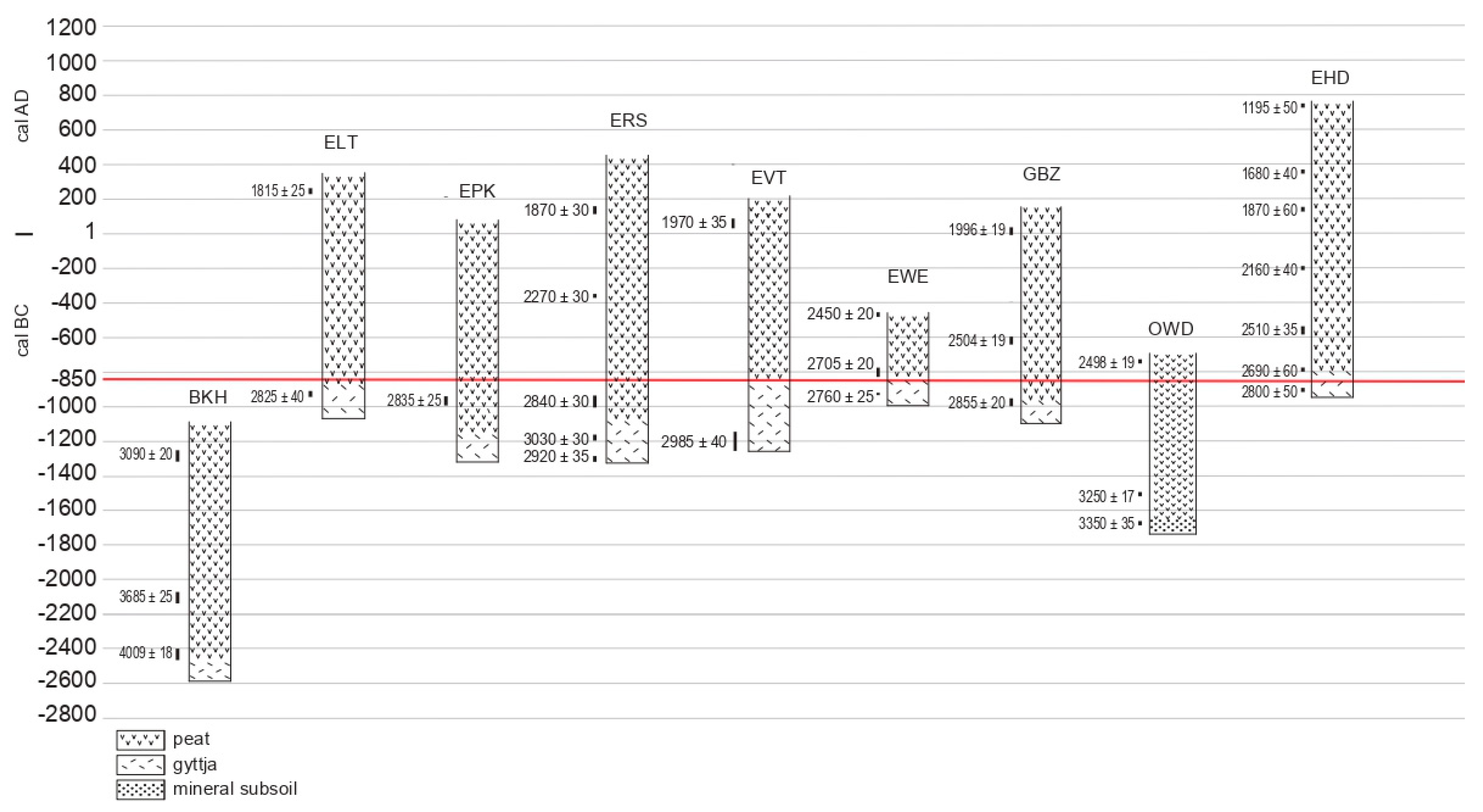
Figure 1. (A) Map of the Netherlands; and position of map (B) that shows the area where samples were taken. Sampling sites are indicated with red dots. Green: meadows; dark green: forested; yellow: arable; grey: villages and towns. (C) Detailed map of the Enkhuizen area showing position of sampling sites: 1: Vijzeltuin (EVT); 2: Raamstraat (ERS); 3: Paktuinen (EPK); 4: Lange Tuinstraat (ELT); 5: Enkhuizen-dijk [17]; 6: Westeinde (EWE); 7: Bovenkarspel (BVK); 8: Grootebroek-Zesstedenweg (GBZ).
Quaternary 03 00012 g001
Figure 2. Example of a sampling site: section of the site Vijzeltuin with sample boxes.
Quaternary 03 00012 g002
Figure 3. (A) Lemna spec., seed; (B) and (C) Hottonia palustris, seeds; (DF) Utricularia spec., seeds; (G) and (H) Tomentypnum nitens, leaf; (I) and (J) charred epidermis fragments Poaceae; (KM) Pinus sylvestris, needle fragments; (NP) Pinus sylvestris, seed wing fragments; (Q) and (R) Pinus sylvestris, seeds; (S) and (T) Pinus sylvestris, mycorrhizal roots.
Quaternary 03 00012 g003
Figure 4. (A) Anthriscus caucalis, seed; (B) and (C) Triglochin maritima, fruit and seeds; (D) and (E) Salicornia europaea, seeds; (FH) Sphaeroceridae, puparia, (H) with adult inside, (G) with a parasitoid Hymenopteron inside; (I) parasitoid wasp Anteris spec. inside an arthropod egg; (J) Ectobius lapponicus/sylvestris, ootheca; (K) HdV-598 spores; (L) HdV-597 macrofossil; (MQ) ascospores of Neurospora (HdV-55B/C) with, and without longitudinal grooves.
Quaternary 03 00012 g004
Figure 5. Diagram of Enkhuizen-Vijzeltuin.
Quaternary 03 00012 g005
Figure 6. The base of the organic accumulation (gyttja and subsequently peat) at the sites Berkhout (BKH), ELT, EPK, ERS, Enkhuizen-Vijzeltuin (EVT), EWE, GBZ, Oostwoud (OWD) from this study and Enkhuizen-Dijk (EHD [17]) along a calendar time axis. The conventional radiocarbon ages (in BP) are indicated at the most probable calendar time position. The red line indicates 850 cal BC, and the illustration shows that at several sites inundation already started before 850 cal BC.
Quaternary 03 00012 g006
Table 1. Archeological project numbers, site names, coordinates, levels of starting organic deposits in meters below Dutch Ordnance Datum (NAP), evidence for nearby Bronze Age archaeology, overlying deposits and archaeological references.
ProjectArchaeological Site NamesCoordinatesStart of Organic Deposit (m-NAP)Bronze Age ArchaeologyOverlying DepositsReference
No.Codes and Short Site NamesXY
410BKH: BerkhoutBerkhout, Westeinde 322126,411516,7032.88AbsentAnthropogenic. 12th or 13th C AD[21]
414BTS: BeetsBeets 47127,375511,361No dataAbsentAnthropogenic. Mid 14th C AD[22]
328BVK: BovenkarspelBovenkarspel, Hoofdstraat 17–19144,798523,4011.98Middle and Late Bronze Age occupationAnthropogenic. 12th C AD[23]
433ELT: Lange TuinstraatEnkhuizen, Lange Tuinstraat 1 tm 35147,971523,5882.39Occupation 300 m from sampling siteReclamation 12th C AD[24]
372EPK: PaktuinenEnkhuizen, Paktuinen-Ridderstraat148,277523,7773.74Occupation 600 m from sampling siteReclamation 12th C AD. Anthrop. from AD 1590[25]
381ERS: RaamstraatEnkhuizen, Raamstraat147,960523,9732.72AbsentAnthropogenic.12th-13th C AD[26]
341EVT: VijzeltuinEnkhuizen, Vijzeltuin-West148,345524,2562.59AbsentAnthropogenic. 15th C AD[27]
369EWE: WesteindeEnkhuizen, Westeinde 107146,789523,6262.39Middle Bronze Age ditchesAnthropogenic. 12th C AD[28]
431GBZ: GrootebroekGrotebroek, Zesstedenweg 203143,591523,3782.98AbsentAnthropogenic. 12th-13th C AD[29]
383OWD: OostwoudOostwoud, Oostwouderdorpsstraat 69134,302527,4411.66Bronze Age ard marksAnthropogenic. 13th C AD[30]
325VEL: ElbawegZuiderdijk, Venhuizen, Elbaweg143,719518,0692.64Middle Bronze Age ditches, pitsAnthropogenic. 14th C AD[31]
325VSP: SpuiterZuiderdijk, Venhuizen, Spuiter142,838517,5152.41AbsentAnthropogenic. 14th C AD[31]
Table 2. Species included in types as based on fruit and seed morphology.
TypeSpecies
Atriplex littoralis-typeAtriplex littoralis/prostrata var. salina
Carex acuta-typeCarex acuta/elata/nigra/trinervis
Carex paniculata-typeCarex appropinquata/diandra/paniculata
Juncus articulatus-typeJuncus acutiflorus/articulatus/bulbosus
Juncus effusus-typeJuncus conglomeratus/effusus/inflexus
Ranunculus repens-typeRanunculus acris/bulbosus/repens
Sagina apetala-typeSagina apetala/micropetala/procumbens
Veronica beccabunga-typeVeronica anagallis-aquatica/beccabunga/catenata
Table 3. Radiocarbon dates and calibration results of samples from the studied West-Frisian sequences. GrM and GrA samples were dated by the Centre for Isotope Research, Groningen and Beta samples by the radiocarbon laboratory of Beta Analytic, London, UK.
SitesDepth (cm)Lab. Code14C BPCalibrations OxCAL 2019–06-09 (IntCal 13): 68.2% ProbabilityMaterial Used for Dating
BKH: Berkhout7 + 8GrM-171163090 ± 20cal BC 1406–1381; 1343–1306Betula leaf, seed, catkin scale, bud scale.
32 + 33GrM-171173685 ± 25cal BC 2133–2082; 2060–2031Betula leaf, bud scale; seeds S. flos-cuculi.
42 + 43GrM-173474009 ± 18cal BC 2568–2519; 2498–2489Carex seeds.
BTS: Beets7 + 8GrM-171151765 ± 20cal AD 240–259; 281–324R. alba seeds, stems; Sphagnum opercula.
ELT: Enkhuizen-Langetuinstr29GrM-171251815 ± 25cal AD 140–160; 166–196; 208–238Betula bud scales, leaves; Musci.
65GrM-178392825 ± 40cal BC 1022–919Seeds: Alisma, Carex, Mentha, Lythrum.
EPK: Enkhuizen-Paktuinen18 + 19GrM-172841950 ± 20cal AD 25–75Menyanthes seed, Betula leaf.
62 + 63GrM-173482835 ± 25cal BC 1018–970; 961–935Carex seeds, Iris pseudacorus seed.
ERS: Enkhuizen-Raamstraat16 + 17Beta-4312131870 ± 30cal AD 82–170; 194–210leaves: Betula, Oxycoccus palustris, musci.
37Beta-4312142270 ± 30cal BC 395–357; 282–257; 244–236Betula leaf, female catkin scale; fern leaf.
68 + 69 + 70Beta-4312152840 ± 30cal BC 1043–971; 960–936Seeds: Cyperaceae, Apiaceae, Iris, Lycopus.
84 + 85 + 86Beta-4312163030 ± 30cal BC 1374–1354; 1302–1226Seeds: Cyperaceae, Apiaceae, Iris, Mentha.
90 + 91 + 92GrA-640002920 ± 35cal BC 1192–1172; 1166–1143; 1132–1051Seeds: Mentha, Glyceria, Apiaceae, Alisma, Solanum, Eleocharis.
EVT: Enkhuizen-Vijzeltuin18GrA-56077985 ± 35cal AD 1014–1048; 1087–1123; 1138–1149Seeds: Chenopodiaceae.
21GrA-560751970 ± 35cal BC 19–13; cal AD 1–72Pinus, female cone fragment.
69 + 70GrA-560732985 ± 40cal BC 1267–1155; 1148–1128Seeds: Cyperaceae, Mentha.
EWE: Enkhuizen-Westeinde13GrM-172852450 ± 20cal BC 742–687; 665–645; 550–485Seeds: Carex, Menyanthes, Apiaceae.
25 + 26GrM-172872705 ± 20cal BC 894–871; 851–818Seeds: Menyanthes, Iris, Apiaceae, Solanum, Ranunculaceae, Caryophyllaceae.
37GrM-171242760 ± 25cal BC 927–891; 879–846Iris pseudacorus seed.
GBZ: Grootebroek-Zesstedenweg48 + 49GrM-172061996 ± 19cal BC 37–29; 22–10; cal BC 2–cal AD 25Pinus needles, Betula leaf, seed Menyanthes.
69 + 70GrM-172072504 ± 19cal BC 767–748; 684–667Seeds: Carex, Menyanthes; musci, fern leaf.
cal BC 641–588; 580–559
96 + 97GrM-172092855 ± 20cal BC 1051–979Carex seeds.
OWD: Oostwoud29GrM-172102498 ± 19cal BC 762–748; 685–666Seeds: Menyanthes, Carex, S. flos-cuculi.
cal BC 642–587; 581–556Betula, Caryophyll., Sphagnum, Polytrichum.
61GrM-172113250 ± 17cal BC 1595–1589; 1532–1499Seeds: Carex, Ranunc., Menyanthes, Lycopus, Apiaceae, Caryophyllaceae.
68GrM-178793350 ± 35cal BC 1690–1611; 1572–1566Seeds: Urtica, Hypericum, Mentha, Solanum, Carex, Juncus.
VEL: Venhuizen-Elbaweg53–54GrA-535391645 ± 30cal AD 353–367; 380–426Alkaline fraction of bulk peat.
68–70GrA-535382465 ± 30cal BC 751–683; 669–636
cal BC 626–614; 592–516
VSP: Venhuizen-Spuiter30GrA-535402450 ± 35cal BC 747–686; 666–643;Alkaline fraction of bulk peat.
cal BC 554–452; 446–430
DitchGrA-535411555 ± 30cal AD 430–494; 510–518;Leaf fragments, bud scales, seeds.
cal AD 528–545

