Safety-Aware Pre-Flight Trajectory Planning for Urban UAVs with Contingency Plans for Mechanical and GPS Failure Scenarios
Abstract
Highlights
- Developed a safety-aware pre-flight trajectory planner that incorporates contingency plans for mechanical failures, GPS denial/spoofing, and communication loss.
- Demonstrated that modest increases in trajectory length can significantly improve safety by ensuring feasible emergency landings and robust operations in urban environments.
- Enhances the reliability of UAV operations under real-world failure scenarios, supporting safe integration of drones into urban airspace.
- Provides a framework aligned with regulatory safety guidelines (FAA, EASA, CASA) that can inform the design of future Unmanned Traffic Management (UTM) systems.
Abstract
1. Introduction
- A safety-aware pre-flight path planner that explicitly integrates proximity to emergency landing zones and GPS fallback options into drone trajectory optimization.
- Contingency planning for failure modes, especially GPS spoofing or signal loss, by planning trajectories within proximity of at least three GSM towers.
- Geospatial integration of urban airspace data, including 3D building models, points of interest (POIs), communication tower locations, and no-fly zones (NFZs), for realistic and constrained path planning.
- A multi-mission simulation framework to model and evaluate various drone operational profiles, including food delivery, security patrol, and environmental monitoring within a controlled urban environment.
2. Literature Review
2.1. Related Work
Pre-Flight Contingency Planning
3. System Outline
4. Simulation Environment
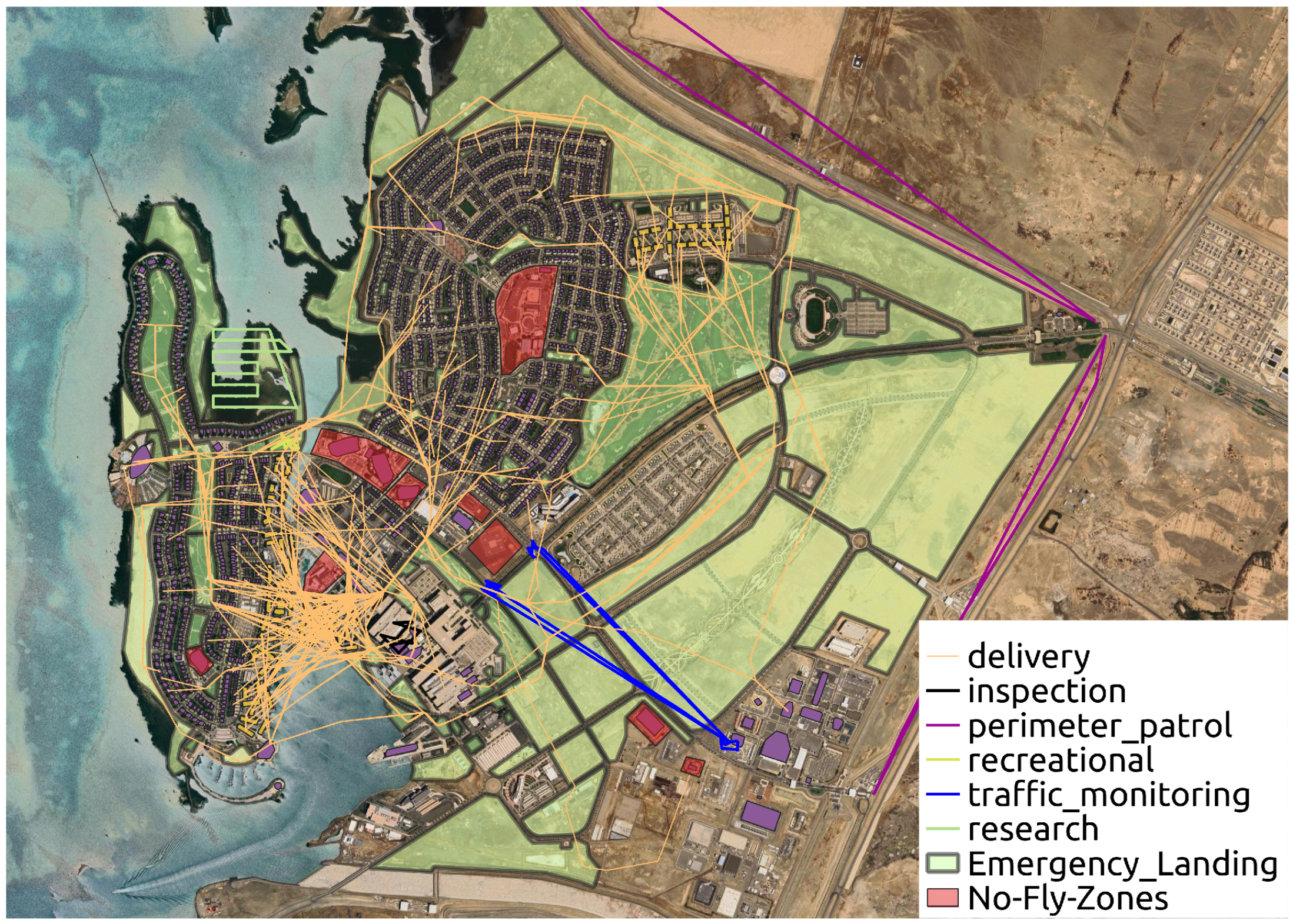
4.1. Environment
4.2. Missions
4.3. Drone Dynamics
4.4. Controller
4.4.1. Definitions
- : state vector at time step k.
- : velocity components of the state at time step k.
- : control input vector at time step k.
- : desired reference state.
- : slack variables for absolute value terms.
- : weighting factor for control effort.
- : state-space model matrices.
- : control input bounds.
- : state bounds.
- N: prediction horizon.
- : polyhedral approximation matrix for the maximum velocity constraint, with rows for .
- : maximum allowed velocity.
4.4.2. Velocity Constraints
4.4.3. Reference Tracking with Waypoints
4.4.4. General Obstacle and NFZ Avoidance Constraints
4.4.5. Obstacle Avoidance in 3D Space
4.4.6. NFZ Avoidance in 2D Projection
4.4.7. Vehicle Collision Avoidance
5. Path Planner
5.1. Problem Setup
5.2. Geometric Constraints
5.2.1. Operational Altitude Constraints
5.2.2. Trilateration Using Communication Towers
5.3. Sampling the Airspace and Connecting the Samples
5.4. The Cost of the Connections
5.5. Graph Fusion
- is normalized to 1 to measure the distance,
- to reward flying through these areas while ensuring the combined graph has no negative edges,
- and are set to very large values to heavily penalize restricted zones.
5.5.1. Tuning the Cost Function
5.5.2. Dynamic Updates
5.6. Key Limitations of the Path Planner
| Algorithm 1 Geometrically constrained path planner. |
|
6. Experiment Setup
6.1. Simulation Setup
6.2. Nominal Operations
Experiments
6.3. Emergency Scenarios
- Immediate landing: the drone descends and lands at the nearest safe location.
- Rerouting: the drone deviates from its original path to avoid hazardous areas or system faults.
- Return to home (RTH): the drone navigates back to its launch point or a designated fallback location.
- Loitering or hover-and-wait: the drone holds position while awaiting further instructions or system recovery.
7. Simulation Results
7.1. Nominal Operations
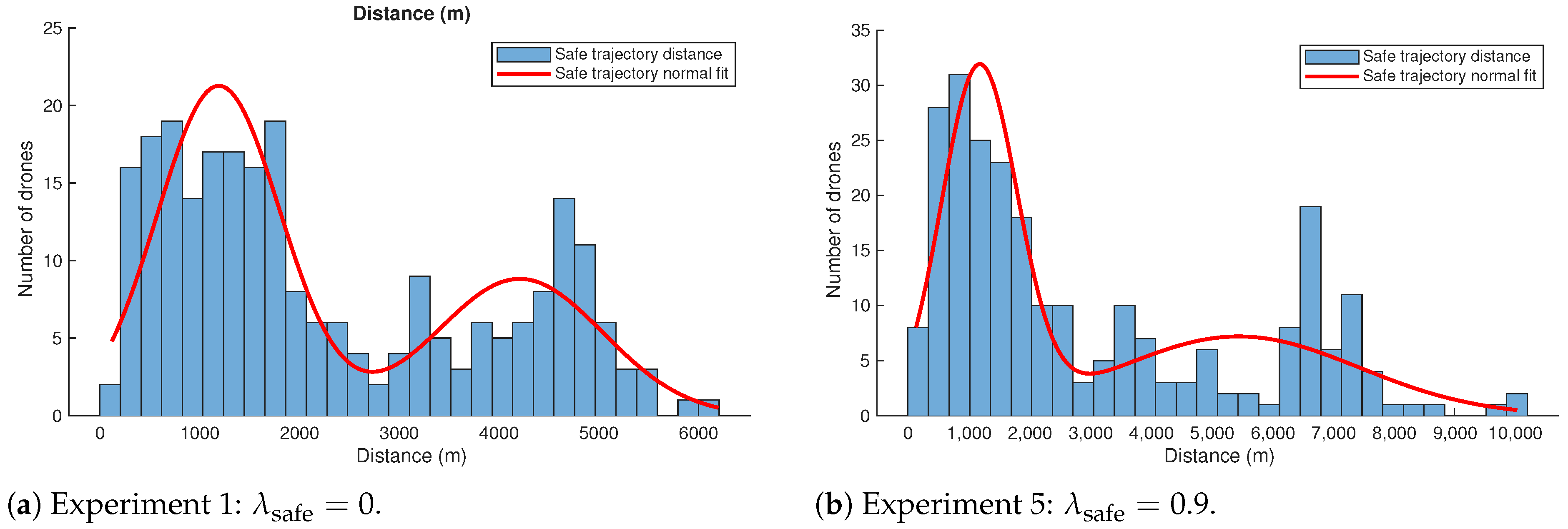
7.1.1. Emergency Landing
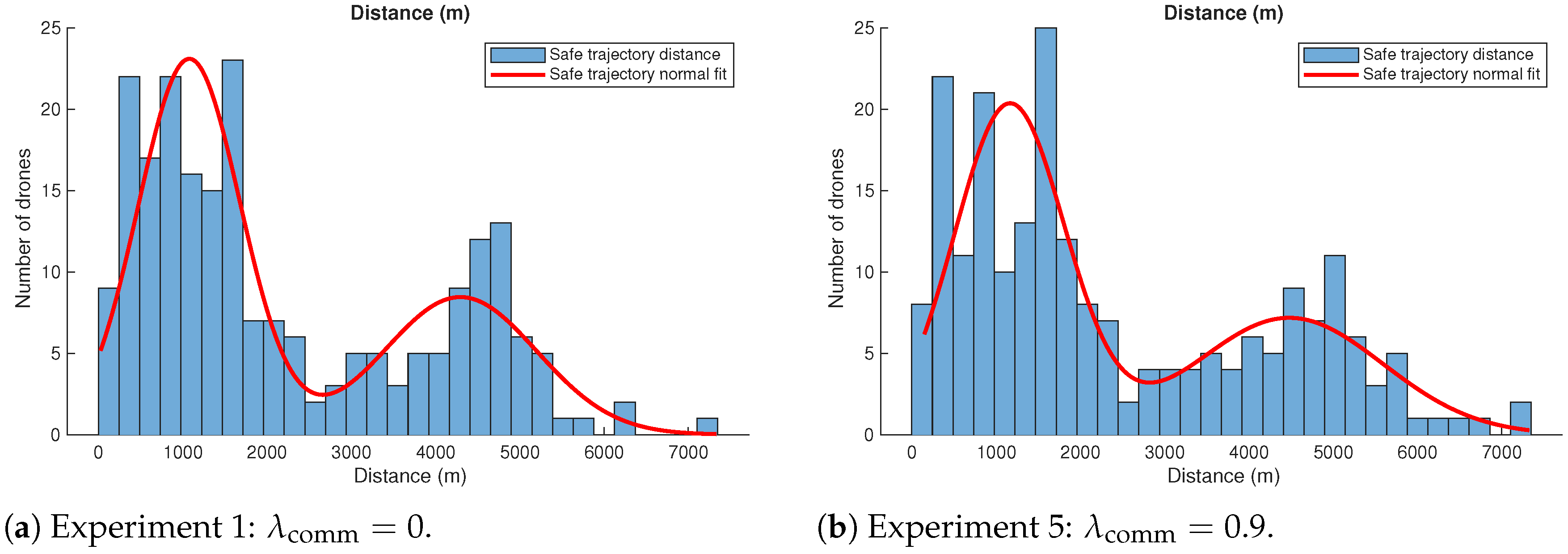
7.1.2. GPS Fallback via Communication Towers
7.2. Emergency Scenarios
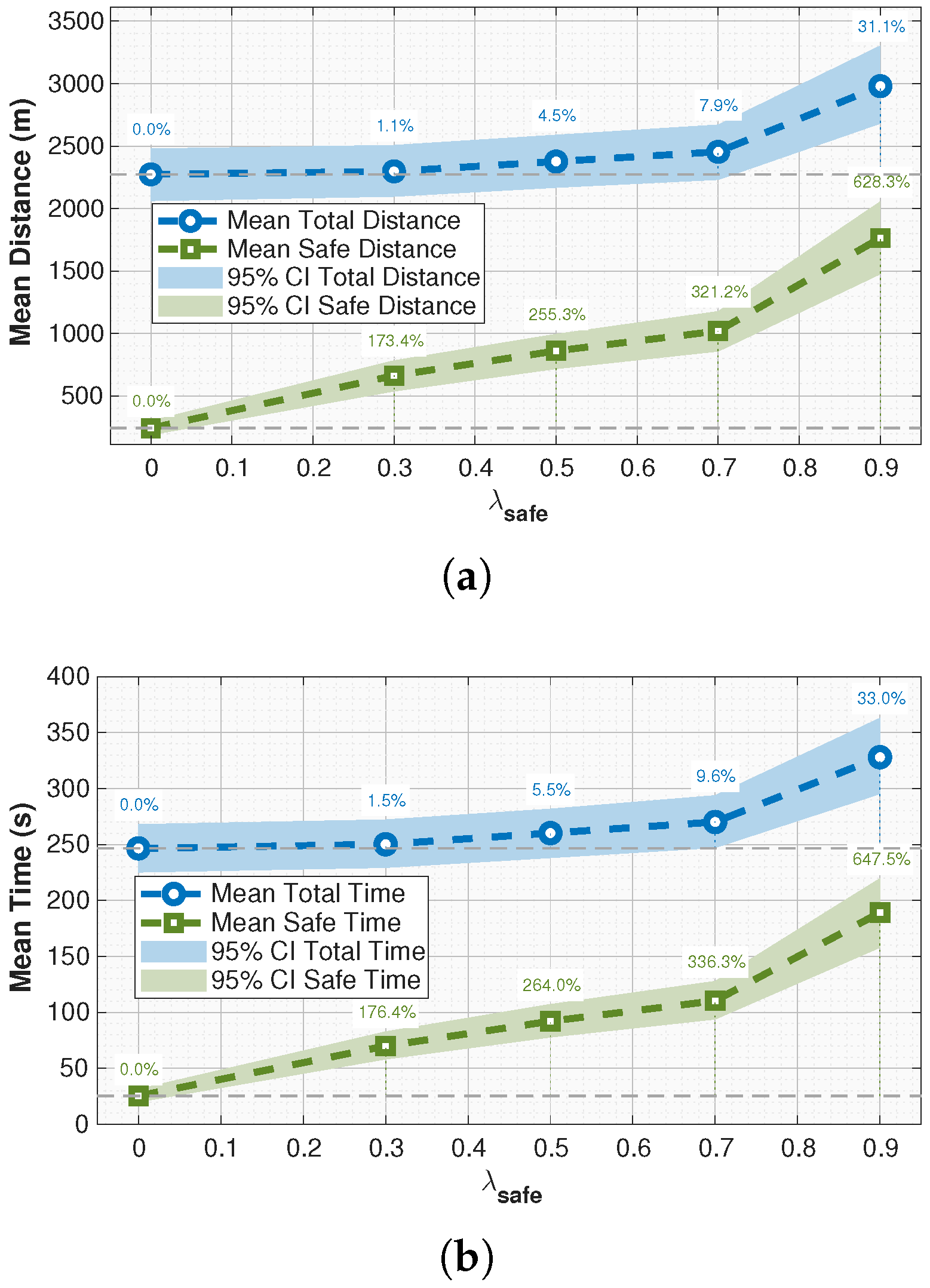
7.2.1. Effect of Emergency Landing-Aware Planning
7.2.2. Effect of Trilateration-Enabled Planning
8. Discussion
8.1. Impact of Safety Weighting on Trajectory Behavior
8.2. Effect of Trilateration-Enabled Planning
9. Conclusions
Author Contributions
Funding
Data Availability Statement
Acknowledgments
Conflicts of Interest
Appendix A
References
- Jenkins, D.; Vasigh, B.; Oster, C.; Larsen, T. Forecast of the Commercial UAS Package Delivery Market; Embry-Riddle Aeronautical University: Daytona Beach, FL, USA, 2017. [Google Scholar]
- Federal Aviation Administration, Office of Aviation Policy and Plans (APO-100). FAA Aerospace Forecast: Fiscal Years 2025–2045; Technical Report; U.S. Department of Transportation, Federal Aviation Administration: Washington, DC, USA, 2025.
- Breunig, J.; Forman, J.; Sayed, S.; Audenaerd, L.; Branch, A.; Hadjimichael, M. Modeling Risk-Based Approach for Small Unmanned Aircraft Systems; Technical Report NASA/TP–2018–219858; NASA Technical Publication; NASA Ames Research Center: Moffett Field, CA, USA, 2018.
- Farajijalal, M.; Eslamiat, H.; Avineni, V.; Hettel, E.; Lindsay, C. Safety Systems for Emergency Landing of Civilian Unmanned Aerial Vehicles (UAVs)—A Comprehensive Review. Drones 2025, 9, 141. [Google Scholar] [CrossRef]
- Jung, J.; Nag, S. Automated Management of Small Unmanned Aircraft System Communications and Navigation Contingency. In Proceedings of the AIAA Scitech 2020 Forum, Orlando, FL, USA, 6–10 January 2020; p. 2195. [Google Scholar]
- Balamurugan, G.; Valarmathi, J.; Naidu, V. Survey on UAV Navigation in GPS Denied Environments. In Proceedings of the 2016 International Conference on Signal Processing, Communication, Power and Embedded System (SCOPES), Paralakhemundi, India, 3–5 October 2016; IEEE: New York, NY, USA, 2016; pp. 198–204. [Google Scholar]
- Tegler, E. GPS Spoofing in the Middle East Is Now Capturing Avionics. Available online: https://www.forbes.com/sites/erictegler/2023/12/05/gps-spoofing-in-the-middle-east-is-now-capturing-avionics/ (accessed on 17 July 2025).
- Lum, C.; Waggoner, B. A Risk Based Paradigm and Model for Unmanned Aerial Systems in the National Airspace. In Proceedings of the Infotech@Aerospace 2011, St. Louis, MI, USA, 29–31 March 2011; AIAA 2011-1424. American Institute of Aeronautics and Astronautics: Reston, VA, USA, 2011; pp. 1–31. [Google Scholar] [CrossRef]
- Civil Aviation Safety Authority (CASA). Recognising, Mitigating and Adapting to GNSS Interference During Flight. Available online: https://www.casa.gov.au/operations-safety-and-travel/aviation-safety-and-security-pilots/recognising-mitigating-and-adapting-gnss-interference-jamming-or-spoofing (accessed on 29 July 2025).
- Federal Aviation Administration (FAA). Concept of Operations v2.0: Unmanned Aircraft System Traffic Management (UTM). Available online: https://www.faa.gov/researchdevelopment/trafficmanagement/utm-concept-operations-version-20-utm-conops-v20 (accessed on 26 August 2025).
- European Union Aviation Safety Agency (EASA). Easy Access Rules for Unmanned Aircraft Systems. Consolidated Version of Regulation (EU) 2019/947 and 2019/945 with AMC and GM. 2022. Available online: https://www.easa.europa.eu/en/downloads/110913/en (accessed on 26 August 2025).
- Zipline. Zipline Drone Delivery and Logistics. Available online: https://www.zipline.com/ (accessed on 20 August 2025).
- Wing. Wing Drone Delivery. The Future of Delivery Is Here. Available online: https://wing.com/ (accessed on 20 August 2025).
- Meituan. Meituan—We Help People Eat Better, Live Better. Available online: https://www.meituan.com/en-US/about-us (accessed on 20 August 2025).
- UPS Flight Forward. UPS Flight Forward Adds New Aircraft. Available online: https://about.ups.com/us/en/newsroom/press-releases/innovation-driven/ups-flight-forward-adds-new-aircraft.html (accessed on 20 August 2025).
- Zipline. Walmart and Zipline Team up to Bring First-of-Its Kind Drone Delivery Service to the United States. Available online: https://corporate.walmart.com/news/2020/09/14/walmart-and-zipline-team-up-to-bring-first-of-its-kind-drone-delivery-service-to-the-united-states (accessed on 20 August 2025).
- Meituan. Meituan Secures China’s First Nationwide Drone Delivery License. Available online: https://technode.com/2025/04/23/meituan-secures-chinas-first-nationwide-drone-delivery-license-ramping-up-competition-with-google-wing/ (accessed on 20 August 2025).
- Lieb, J.; Volkert, A. Unmanned Aircraft Systems Traffic Management: A Comparison on the FAA UTM and the European CORUS ConOps Based on U-Space. In Proceedings of the 2020 AIAA/IEEE 39th Digital Avionics Systems Conference (DASC), Virtual, 11–15 October 2020; IEEE: New York, NY, USA, 2020; pp. 1–6. [Google Scholar]
- Weibel, R.; Hansman, R.J. Safety Considerations for Operation of Different Classes of UAVs in the NAS. In Proceedings of the AIAA 4th Aviation Technology, Integration and Operations (ATIO) Forum, Chicago, IL, USA, 20–22 September 2004; p. 6244. [Google Scholar]
- Clothier, R.A.; Walker, R.A. Safety Risk Management of Unmanned Aircraft Systems. In Handbook of Unmanned Aerial Vehicles; Springer: Berlin/Heidelberg, Germany, 2015; pp. 2229–2275. [Google Scholar]
- Ayhan, B.; Kwan, C.; Budavari, B.; Larkin, J.; Gribben, D. Preflight Contingency Planning Approach for Fixed-Wing UAVs with Engine Failure in the Presence of Winds. Sensors 2019, 19, 227. [Google Scholar] [CrossRef]
- Lin, C.E.; Shao, P.C. Failure Analysis for an Unmanned Aerial Vehicle Using Safe Path Planning. J. Aerosp. Inf. Syst. 2020, 17, 358–369. [Google Scholar] [CrossRef]
- Bobick, J.C.; Bryson, A.E., Jr. Improved Navigation by Combining VOR/DME Information with Air or Inertial Data; Technical Report STAN-M-72-31; Stanford University: Stanford, CA, USA, 1972. [Google Scholar]
- Sulieman, M.H.; Liu, M.; Gursoy, M.C.; Kong, F. Path Planning for UAVs Under GPS Permanent Faults. ACM Trans. Cyber-Phys. Syst. 2025, 8, 31. [Google Scholar] [CrossRef]
- Almozel, A.; Feron, E.M.; Saber, S.I.; Cloiseau, C.; Vanderventer, K. Safe Trajectory Planning for Safety Critical Drone Delivery. In Proceedings of the AIAA AVIATION 2023 Forum, San Diego, CA, USA, 12–16 June 2023; p. 3547. [Google Scholar]
- Hamissi, A.; Dhraief, A. A Survey on the Unmanned Aircraft System Traffic Management. ACM Comput. Surv. 2023, 56, 68. [Google Scholar] [CrossRef]
- Johansen, K.; Dunne, A.F.; Tu, Y.H.; Almashharawi, S.; Jones, B.H.; McCabe, M.F. Dye tracing and concentration mapping in coastal waters using unmanned aerial vehicles. Sci. Rep. 2022, 12, 1141. [Google Scholar] [CrossRef] [PubMed]
- Benarbia, T.; Kyamakya, K. A Literature Review of Drone-Based Package Delivery Logistics Systems and Their Implementation Feasibility. Sustainability 2021, 14, 360. [Google Scholar] [CrossRef]
- Holkar, K.S.; Waghmare, L.M. An Overview of Model Predictive Control. Int. J. Control Autom. 2010, 3, 47–63. [Google Scholar]
- Boyd, S.P.; Vandenberghe, L. Convex Optimization; Cambridge University Press: Cambridge, UK, 2004. [Google Scholar]
- Zhu, W. Getting a Drone to Deliver Your Coffee at the Great Wall! China Daily. 2025. Available online: https://www.chinadaily.com.cn/a/202503/24/WS67e0b04fa310c240449dc6c9.html (accessed on 20 August 2025).
- QGroundControl. QGroundControl: Ground Control Station for MAVLink Protocol. Available online: https://qgroundcontrol.com/ (accessed on 25 August 2025).
- SPH Engineering. UgCS: Flight Planning and Control Software. Available online: https://www.sphengineering.com/flight-planning/ugcs (accessed on 25 August 2025).
- ArduPilot Development Team. Mission Planner: Ground Control Station. Available online: https://ardupilot.org/planner/ (accessed on 25 August 2025).
- Schouwenaars, T.; How, J.; Feron, E. Receding Horizon Path Planning with Implicit Safety Guarantees. In Proceedings of the 2004 American Control Conference, Boston, MA, USA, 30 June–2 July 2004; IEEE: New York, NY, USA, 2004; Volume 6, pp. 5576–5581. [Google Scholar]
- Bondy, J.A.; Murty, U.S.R. Graph Theory with Applications; Macmillan: London, UK, 1976; Volume 290. [Google Scholar]
- Bridson, R. Fast Poisson Disk Sampling in Arbitrary Dimensions. In Proceedings of the SIGGRAPH07: Special Interest Group on Computer Graphics and Interactive Techniques Conference, San Diego, CA, USA, 5–9 August 2007; Volume 10, p. 1. [Google Scholar]






| Parameter | Value/Description |
|---|---|
| Prediction horizon (N) | 50 steps |
| Time step () | 0.1 s |
| Prediction horizon length | 5 s |
| Planner type | MPC with slack variables |
| Maximum velocity () | 10 m/s (polyhedral approximation with 16 angles) |
| Maximum acceleration () | 2 m/s2 (assumed, based on comparable delivery UAVs) |
| Weights () | Tunable, scenario-dependent |
| Simulator time resolution | 0.1 s |
| Solver | Gurobi 12.0.2 and Python 3.15 |
| Experiment | |||||
|---|---|---|---|---|---|
| 1 | 1 | 0 | 0 | ||
| 2 | 1 | 0.3 | 0 | ||
| 3 | 1 | 0.5 | 0 | ||
| 4 | 1 | 0.7 | 0 | ||
| 5 | 1 | 0.9 | 0 |
| Experiment | |||||
|---|---|---|---|---|---|
| 1 | 1 | 0 | 0 | ||
| 2 | 1 | 0 | 0.3 | ||
| 3 | 1 | 0 | 0.5 | ||
| 4 | 1 | 0 | 0.7 | ||
| 5 | 1 | 0 | 0.9 |
| Distance (m) | Safe Dist. (m) | Distance (%) | Safe Dist. (%) | |
|---|---|---|---|---|
| 0.0 | 2273.85 (2077.92–2482.00) | 242.22 (187.60–298.49) | – | – |
| 0.3 | 2297.95 (2100.00–2499.77) | 662.30 (548.42–785.87) | +1.1% | +173.4% |
| 0.5 | 2376.84 (2164.41–2604.45) | 860.66 (729.10–995.10) | +4.5% | +255.4% |
| 0.7 | 2454.31 (2228.78–2668.17) | 1020.09 (873.93–1187.18) | +7.9% | +321.2% |
| 0.9 | 2980.07 (2676.11–3284.44) | 1764.01 (1483.43–2054.54) | +31.1% | +628.5% |
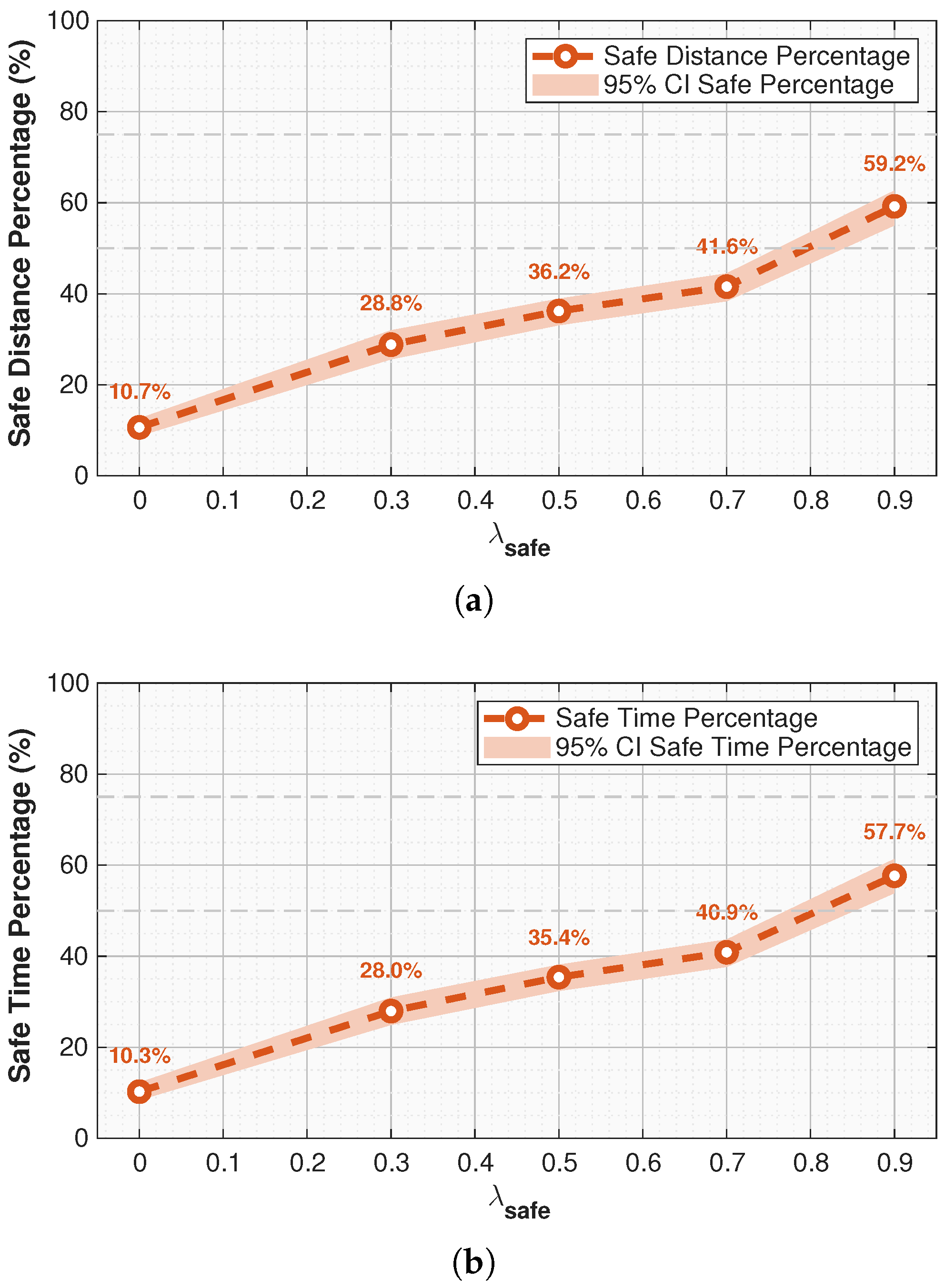
| Mean Coverage (%) | 95% CI (%) | Coverage (%) | |
|---|---|---|---|
| 0.0 | 10.7 | [8.8, 12.6] | – |
| 0.3 | 28.8 | [25.7, 31.7] | +18.1 |
| 0.5 | 36.2 | [33.1, 39.5] | +25.5 |
| 0.7 | 41.6 | [38.4, 44.4] | +30.9 |
| 0.9 | 59.2 | [55.2, 62.7] | +48.5 |
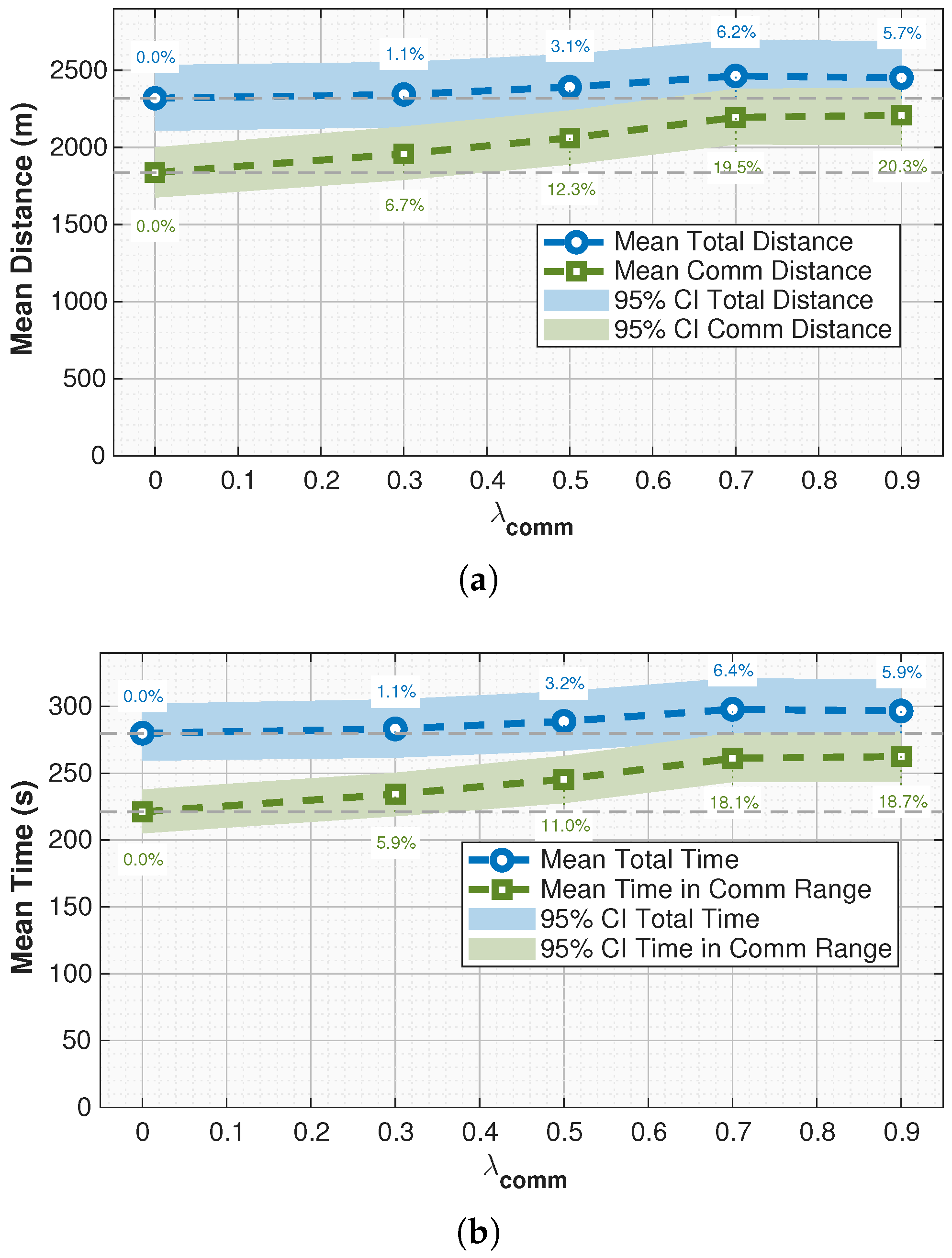
| Distance (m) | Comm Dist. (m) | Distance (%) | Comm Dist. (%) | |
|---|---|---|---|---|
| 0.0 | 2318.99 (2114.19–2525.45) | 1836.29 (1681.49–2003.39) | – | – |
| 0.3 | 2343.58 (2139.83–2549.86) | 1958.43 (1791.55–2122.65) | +1.1% | +6.7% |
| 0.5 | 2391.64 (2190.14–2607.78) | 2061.76 (1883.58–2233.89) | +3.1% | +12.3% |
| 0.7 | 2463.61 (2245.11–2692.06) | 2194.82 (2015.52–2378.34) | +6.2% | +19.5% |
| 0.9 | 2451.80 (2227.63–2684.49) | 2208.37 (2022.15–2392.47) | +5.7% | +20.3% |
| Mean Coverage (%) | 95% CI (%) | Coverage (%) | |
|---|---|---|---|
| 0.0 | 79.2 | [75.7, 82.4] | – |
| 0.3 | 83.6 | [81.0, 86.1] | +4.4 |
| 0.5 | 86.2 | [84.2, 88.2] | +7.0 |
| 0.7 | 89.1 | [87.7, 90.6] | +9.9 |
| 0.9 | 90.1 | [88.7, 91.5] | +10.9 |
Disclaimer/Publisher’s Note: The statements, opinions and data contained in all publications are solely those of the individual author(s) and contributor(s) and not of MDPI and/or the editor(s). MDPI and/or the editor(s) disclaim responsibility for any injury to people or property resulting from any ideas, methods, instructions or products referred to in the content. |
© 2025 by the authors. Licensee MDPI, Basel, Switzerland. This article is an open access article distributed under the terms and conditions of the Creative Commons Attribution (CC BY) license (https://creativecommons.org/licenses/by/4.0/).
Share and Cite
Almozel, A.; Adil, A.; Feron, E. Safety-Aware Pre-Flight Trajectory Planning for Urban UAVs with Contingency Plans for Mechanical and GPS Failure Scenarios. Drones 2025, 9, 708. https://doi.org/10.3390/drones9100708
Almozel A, Adil A, Feron E. Safety-Aware Pre-Flight Trajectory Planning for Urban UAVs with Contingency Plans for Mechanical and GPS Failure Scenarios. Drones. 2025; 9(10):708. https://doi.org/10.3390/drones9100708
Chicago/Turabian StyleAlmozel, Amin, Ania Adil, and Eric Feron. 2025. "Safety-Aware Pre-Flight Trajectory Planning for Urban UAVs with Contingency Plans for Mechanical and GPS Failure Scenarios" Drones 9, no. 10: 708. https://doi.org/10.3390/drones9100708
APA StyleAlmozel, A., Adil, A., & Feron, E. (2025). Safety-Aware Pre-Flight Trajectory Planning for Urban UAVs with Contingency Plans for Mechanical and GPS Failure Scenarios. Drones, 9(10), 708. https://doi.org/10.3390/drones9100708


