1. Introduction
The measurement of wind speed and direction is a critical component in meteorological studies, renewable energy optimization, and environmental monitoring. Traditional methods, such as anemometers mounted on stationary towers or weather balloons, face limitations in spatial resolution, mobility, and operational costs. In recent years, multirotor unmanned aerial vehicles (UAVs), particularly quadcopters (Drones), have emerged as transformative tools for wind sensing due to their maneuverability, portability, and ability to operate in complex terrains. UAV-based wind measurements primarily employ two strategies: instrument-based and flight-dynamic-based methods.
Instrument-based methods employ dedicated sensors such as ultrasonic anemometers or pitot tubes mounted on unmanned aerial vehicles (UAVs). For instance, Vaisala’s WINDCAP
® ultrasonic sensors (Helsinki, Finland) measure the wind speed using time-of-flight differences between ultrasonic pulses. These sensors offer robustness against mechanical wear and achieve high temporal resolution (up to 20 Hz). However, the integration of such sensors into UAV systems presents challenges, including aerodynamic interference caused by the UAV’s propellers and alignment errors during dynamic maneuvers. In addition, the direct measurement methods, which rely on instruments integrated directly into UAVs, are also affected by factors such as vehicle vibrations, rotor-induced turbulence, and changes in the center-of-gravity position during extreme conditions (e.g., strong winds or rain). These challenges can lead to degraded sensor performance and operational issues. Bruschi et al. (2019) [
1] found that 2D anemometers mounted on quadcopters overestimated wind speeds by 20% when the UAV tilted by more than 10°. To address these limitations, Donnell et al. (2018) [
2] proposed that calibrations in controlled environments can mitigate sensor errors but require extensive testing in wind tunnels or other controlled conditions. An alternative instrument-based method known as wind pressure orthogonal decomposition (WPOD) was introduced by Hou et al. (2023) [
3]. The WPOD method requires a multicopper onboard sensor consisting of four rigid tubes, which capture wind pressure variations from the incoming airflow; the variations are then converted into wind speed via orthogonal decomposition.
Indirect methods infer wind vectors from the UAV’s flight dynamics by leveraging onboard sensors such as inertial measurement units (IMUs) and GPS modules to estimate the aerodynamic forces and moments. By solving equations of motion based on these sensor measurements, the wind speed and direction are derived from deviations in the UAV’s attitude, thrust, and trajectory. For instance, Johansen et al. (2015) [
4] demonstrated that wind estimation could be achieved by analyzing the UAV’s response to disturbances, requiring precise knowledge of the vehicle’s inertia and drag coefficients. While this approach minimizes the payload weight and power consumption, its accuracy is highly sensitive to aerodynamic modeling errors and turbulence. Recent studies by Allison et al. (2019) [
5] have integrated machine learning techniques to refine the drag coefficient predictions, reducing the wind speed estimation errors to ±1 m/s under steady conditions. Regarding in-flight wind measurement techniques, most methods today employ an inertial plus power-based approach [
6]. These rely on a simplified mechanical equilibrium model and a forcing model derived from rotors. In real-world applications, this simplified model can provide a basic description of wind conditions but often requires modifications in the form of refined equations and calibration of coefficients to improve the accuracy. Such adjustments become critical sources of uncertainty in practical implementations.
A recent study compared the capabilities of both UAV-based wind measurement methods, which suggested instrument-based methods such as a Dopplar LIDAR, have a higher advantage in terms of accuracy and precision, but there is added complexity to the system by an extra instrument [
7]. The study also suggested indirect measurement, on the other hand, e.g., force balance, yields measurements of lower quality.
This study presents a novel machine learning-based method (ML) to investigate the link between wind conditions and drone flight dynamics, encompassing the rotor performance. Modern flight controllers enable drones to maintain dynamic equilibrium against surrounding airflow for greater flight robustness and stability [
8]. To further improve the wind measurement accuracy, we applied ML algorithms to analyze flight controller records, which capture the equilibrium states between the UAV motion and airflow. This innovative method offers a fresh solution for wind measurement from UAVs.
2. Methods
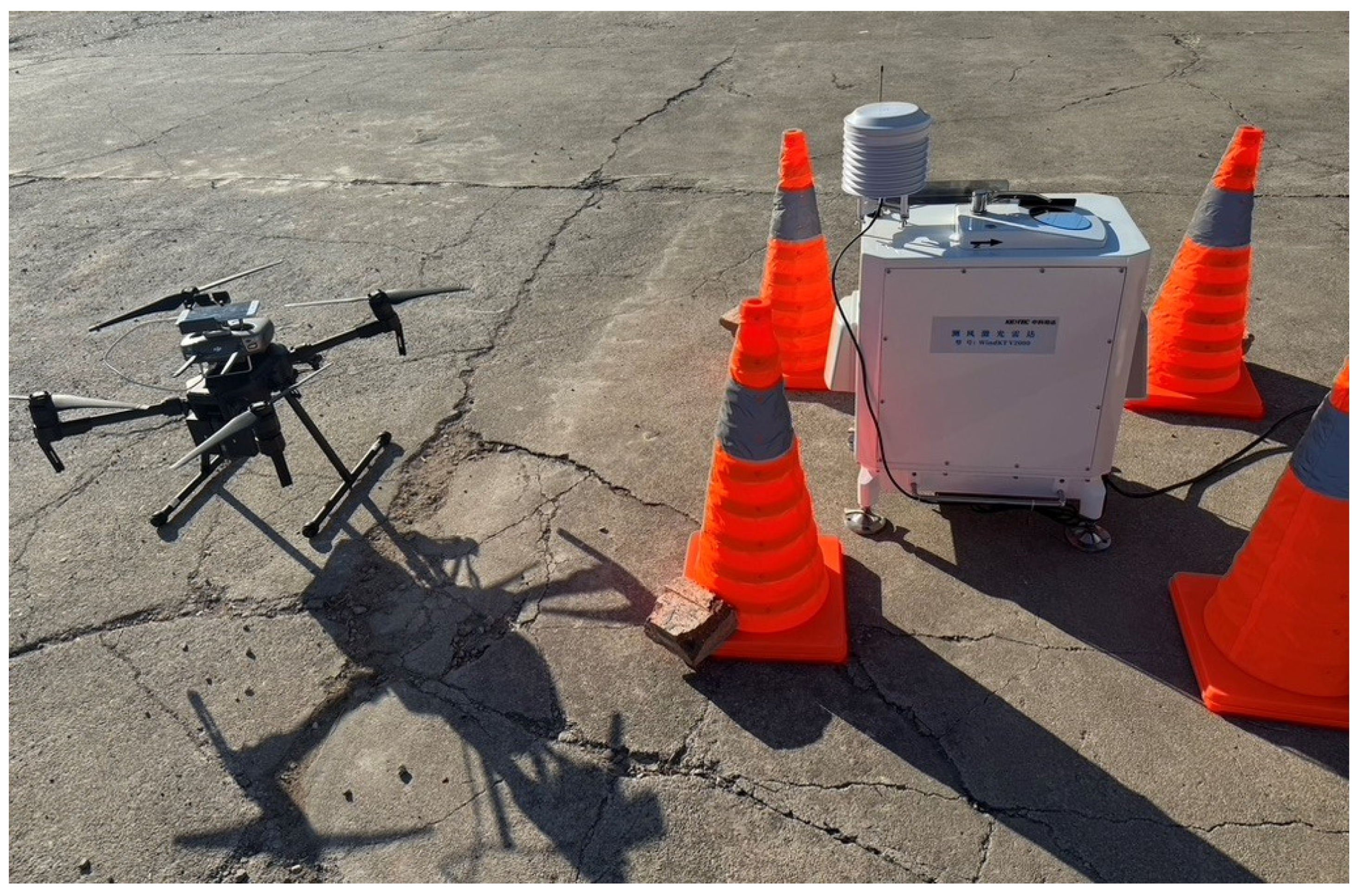
Our methodology builds upon existing setups such as the DJI M200 quadrotor UAV (DJI, Shenzhen, China) (
Figure 1), known for its compact design and extended operational endurance of up to 27 min on a TB50 battery. This UAV’s high stability makes it suitable for maintaining accurate flight control data, which is crucial for wind measurement applications. The system incorporates an ultrasonic anemometer from FT Technologies Ltd. (FT 742-SM, Sunbury-on-Thames, UK) installed on the DJI M300, providing real-time 2D wind speed and direction measurements. Such instruments are essential tools that were widely used in recent studies [
9]. To acquire more accurate wind measurements, we used a wind LiDAR WindKT V2000 (
Figure 1), which was provided by WuHan Xiangfeng Tech. Ltd. (Wuhan, China) It measures the wind speed with a less than 0.1 m/s error (@1 Hz sampling) and has a vertical resolution of 15 m. The hover-based flight takes place around the LiDAR measurement region (105 m above ground with 71° field of view angle), which is ~50 m away from the optical axis center to avoid the beam scanning impact on the LiDAR system. The synchronization of timestamps for data collection is managed through internet-based timekeeping or GPS, ensuring seamless integration across datasets collected at different altitudes and operational periods.
Assuming the wind measurement from LiDAR is true, we applied a random forest (RF) machine learning (ML) algorithm to the respective measurements. RF is a well-known and commonly used ML algorithm. For regression, RF is an ensemble method that constructs multiple decision trees during training and outputs the mean prediction of individual trees for continuous target variables. In this case, RF instantiated multiple decision trees according to a random data section of 28 flight controller parameters (specific description included in
Table S1).
The training objective was to predict the horizontal wind speed, horizontal wind direction, and vertical wind speed by UAV flight dynamics as an all-in-one measurement. Twenty-eight parameters were selected from the UAV flight controller dataset, including the yaw, roll, pitch, quaternion, angular velocity, inclination, motor speed, and air density. Through principal component analysis (PCA), we determined that 15 out of the total 28 parameters provided independent information. However, we included the 28 parameters within the training dataset since the 15 independent principal components cannot represent flight dynamics in the physical parameter space. SHapley Additive exPlanations (SHAP) was applied to infer the importance of each flight controller parameter (See
Supplementary Information).
The random forest model was set up by considering the specific wind measurement problem; hence, the selection of hyperparameters was relatively neutral and optimized after. In general, we chose 100 trees in our model with a minimum number of branch node observations and the number of predictor variables (randomly selected) for each decision split set as 5 and 10. The density distributions of the measured wind speed and wind direction values are shown in
Figures S6 and S7. The measured 28,005 data pairs (@1 Hz sampling) was separated into a training and testing dataset, respectively, with a ratio of 70:30 (in percent, %). Despite the validation dataset being dependent on the testing dataset, the validation dataset was able to optimize the hyperparameter options.
3. Results
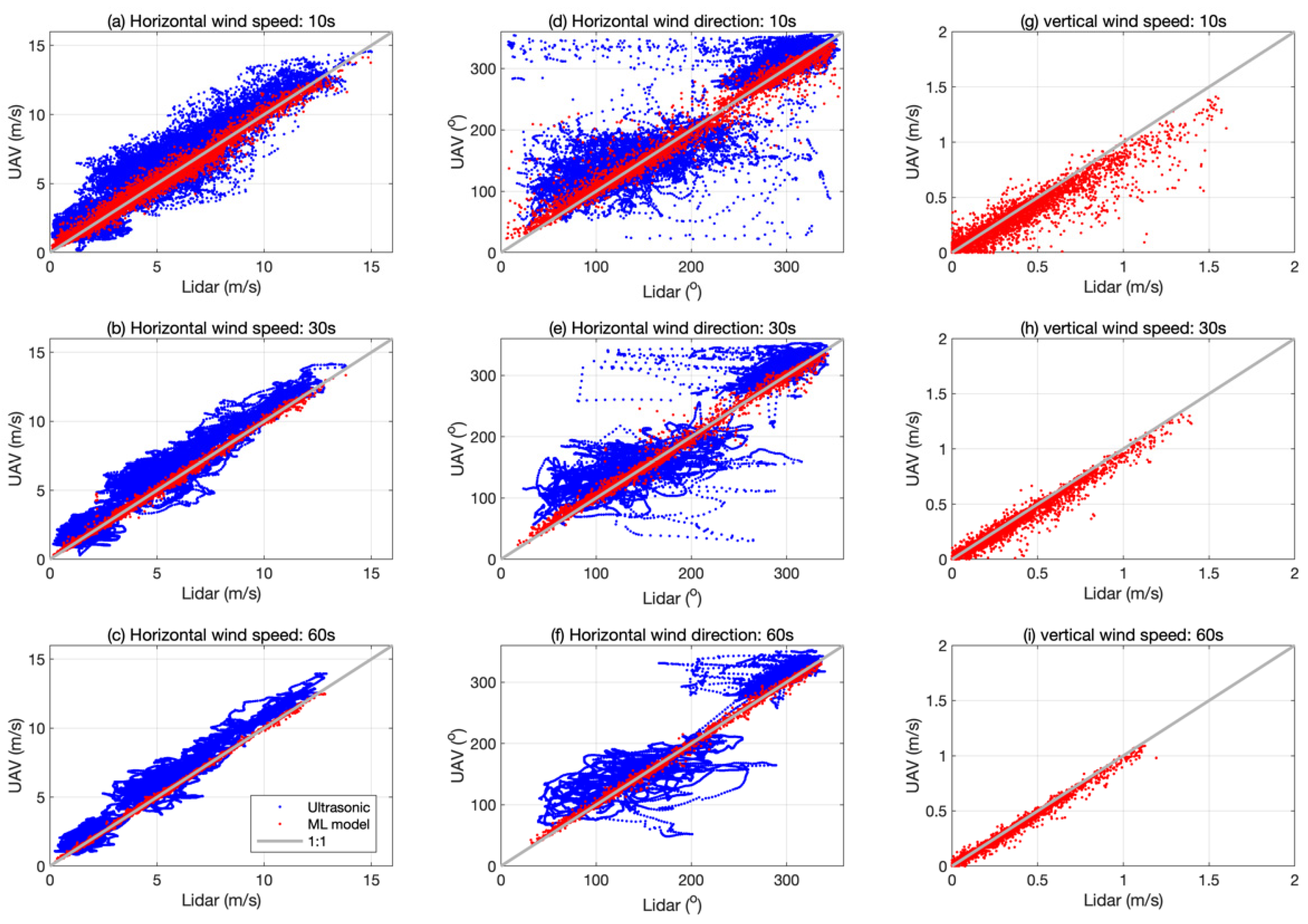
The aim of our measurement is to establish an ML model representing the wind speed and direction from UAV flight dynamics parameters only. The comparison of LiDAR, ML model prediction (only from the testing dataset), and UAV direct measurement by ultrasonic anemometer is shown in
Figure 2, along with 10 s, 30 s, and 60 s smoothing windows. Lower scattering comes with a longer smoothing window, which is due to the reduced impact of noise. We determined that the ML model shows higher consistency than the anemometer with a lower root mean square error (RMSE). Additionally, the ML results had almost no bias (<0.005 m/s @ horizontal wind speed, 10 s smoothing) when the anemometer measurements were biased by 7 m/s compared to the LiDAR measurements. The 10 s smoothing horizontal wind speed measurements demonstrated an RMSE of 0.36 m/s, which meets the World Meteorological Organization (WMO) Observing Systems Capability Analysis and Review (OSCAR) standard [
10]. This result represents an improvement over the average accuracy of 0.58 ± 0.31 m/s [
9] achieved by the forces balance method [
11]. An even higher precision of 0.069 m/s (RMSE) in a 1 min timescale was achieved, which is higher than CopterSonde’s [
12] measurement of 0.77 m/s RMSE in the Oklahoma campaign [
13]. The ML method produced similar level of measurement error compared to the WPOD method, which had a measurement error of 0.3 m/s [
3]. Reviews of recent studies showed errors ranging from 0.27 m/s [
9] to 1.13 m/s [
2] with the direct horizontal wind speed measurement (Table 3 in [
14]), which indicates the ML method result falls in a reliable region. For indirect measurement, an error range from 0.6 m/s [
15] to 4.41 m/s [
16] was reported in recent studies (Table 4 in [
14]).
The precision of the ML model on the horizontal wind direction is very clearly shown in
Figure 2 (middle column), in which the RMSE of the ML method is 12.6° in 10 s and 2.75° in 60 s measurements, without bias. Instrument-based measurements of horizontal wind direction have been reported with an error of 12° [
17], while the indirect measurements have an error of 14.2° [
15]. Therefore, the ML method has an obvious advantage in the horizontal wind direction. The campaign results presented less reliable measurements from the anemometer compared to measurements from the ML model.
The vertical wind speed had a relatively low value in general; the 10 s and 30 s smoothing results show more obvious scattering than the horizontal counterpart. In addition, the ML method could provide a bias-less measurement, and the trained model is applicable for UAVs of same models. Because the anemometer measures only two-dimensional wind, we cannot compare measurements of the vertical wind speed in this study.
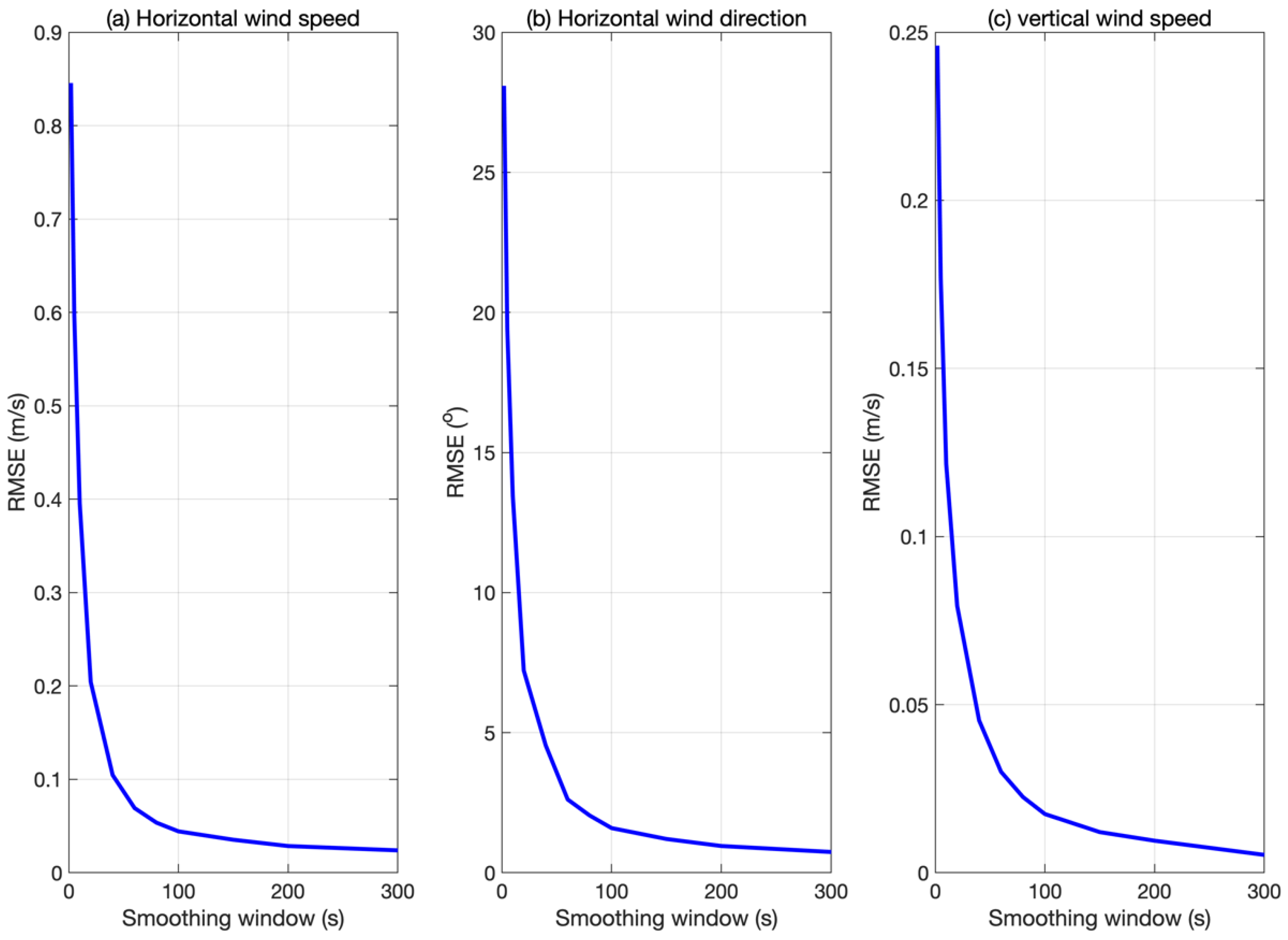
We found the RMSE reduced sharply with the smoothing window tending towards 100 s, and the RMSE reduced smoothly afterward (
Figure 3). To obtain a reliable measurement on the wind speed and direction using the ML method, the smoothing window of measurements should be at least 10 s (0.1 Hz).
The RMSE of the 10 s smoothing horizontal wind speed measurements demonstrated a significant improvement as the smoothing window increased. As shown in
Figure 3, the RMSE exhibited an abrupt decline with larger smoothing windows, reaching a minimum value of 0.1 m/s for the horizontal wind speed when the window exceeded 50 s. This result highlights the effectiveness of the machine learning (ML) method in reducing measurement errors under varying timescales and conditions.
The choice of the frequency of wind measurements depends on the specific research topic. For turbulence studies, extremely high-frequency data are required to capture rapid changes in wind conditions. However, common meteorological applications typically focus on lower frequencies, such as hourly data. The precision achieved by the ML-based method surpasses traditional techniques like the forces balance method [
11] under higher smoothing windows, while also meeting the WMO OSCAR requirements for wind speed measurements when the window exceeds 10 s. The precision is even higher than the LiDAR’s measurements at a single altitude level when the smoothing window exceeds 50 s. The ML wind estimation method is based on the UAV’s position hold flight mode while resisting wind flow; hence, small turbulence and gusts can temporarily disturb the equilibrium by altering the position of the UAV. Under such effects, the flight controller data can potentially contribute to errors if the effect is not fully taken into account during model training.
4. Outlooks
As demonstrated by Zhao et al. (2022) [
18]; Yang et al. (2024) [
19], and Zhao et al. (2024) [
20] in the Low-cost UAV Coordinated Carbon Observation Network (LUCCN) project, uncertainties in wind speed and direction significantly contribute to carbon flux inversion errors, particularly within data assimilation processes and integrated mass enhancement methods. The coordinated observation of CO
2 levels alongside enhanced wind measurements has the potential to enhance inversion accuracy.
While previous studies have established capabilities in low-altitude meteorological applications, there is further potential for improvements. Notably, wind measurement remains a significant challenge in conventional atmospheric conditions due to its sensitivity and variability. However, advancements in machine learning techniques applied to UAV-based systems offer promising solutions without requiring specialized onboard instruments.
The potential development of China’s low-altitude economy presents new opportunities for three-dimensional meteorological measurements, with wind measurement at ground level being particularly challenging. By leveraging machine learning algorithms on existing UAV platforms, it is feasible to achieve accurate and precise wind data through swarm operations in three dimensions, thereby addressing the limitations of traditional methods.
This approach not only enhances the accuracy of wind measurements but also opens new avenues for atmospheric research and environmental monitoring applications.


