
Drone Applications Fighting COVID-19 Pandemic—Towards Good Practices


Abstract
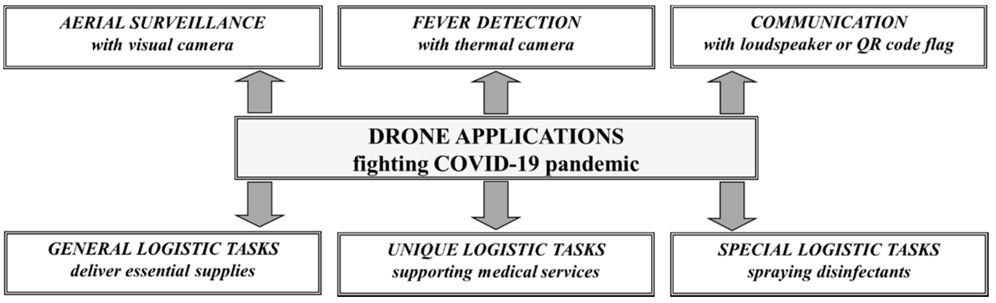
:1. Introduction
2. Materials and Methods
3. Results
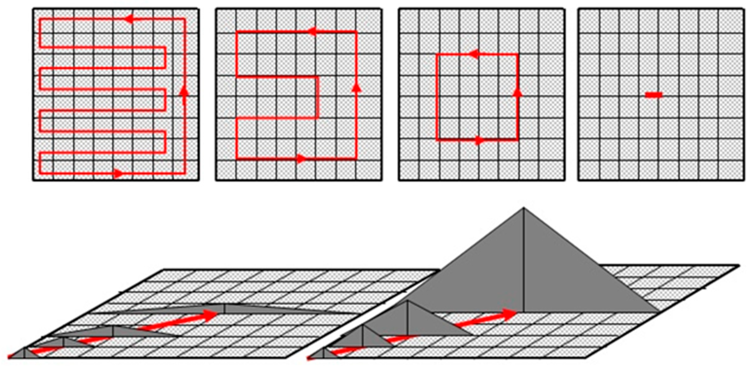
3.1. Aerial Surveillance with Visual Camera
3.1.1. General Characteristics of Area Monitoring or Aerial Surveillance
3.1.2. Analysis and Evaluation of Applied Practices
3.1.3. Requirements of Good Practice
3.1.4. Future Work Required to Improve the Present Practices
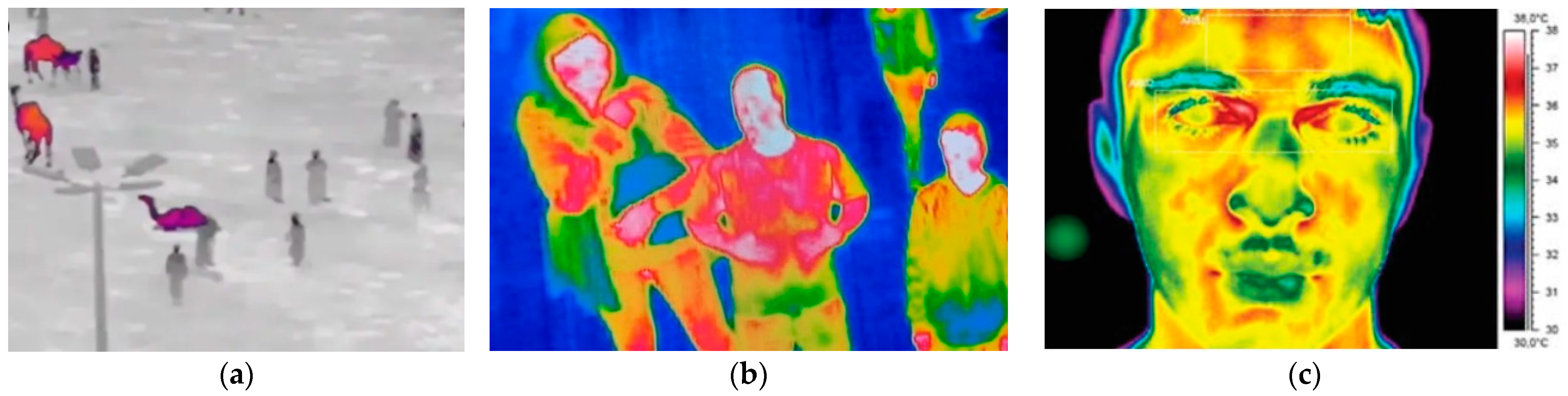
3.2. Aerial Survillance with Thermal Camera to Detect Febrile Patient
3.2.1. General Characteristics of Detecting Febrile Patient
3.2.2. Analysis and Evaluation of Applied Practices
3.2.3. Requirements of Good Practice
3.2.4. Future Work Required to Improve the Present Practices
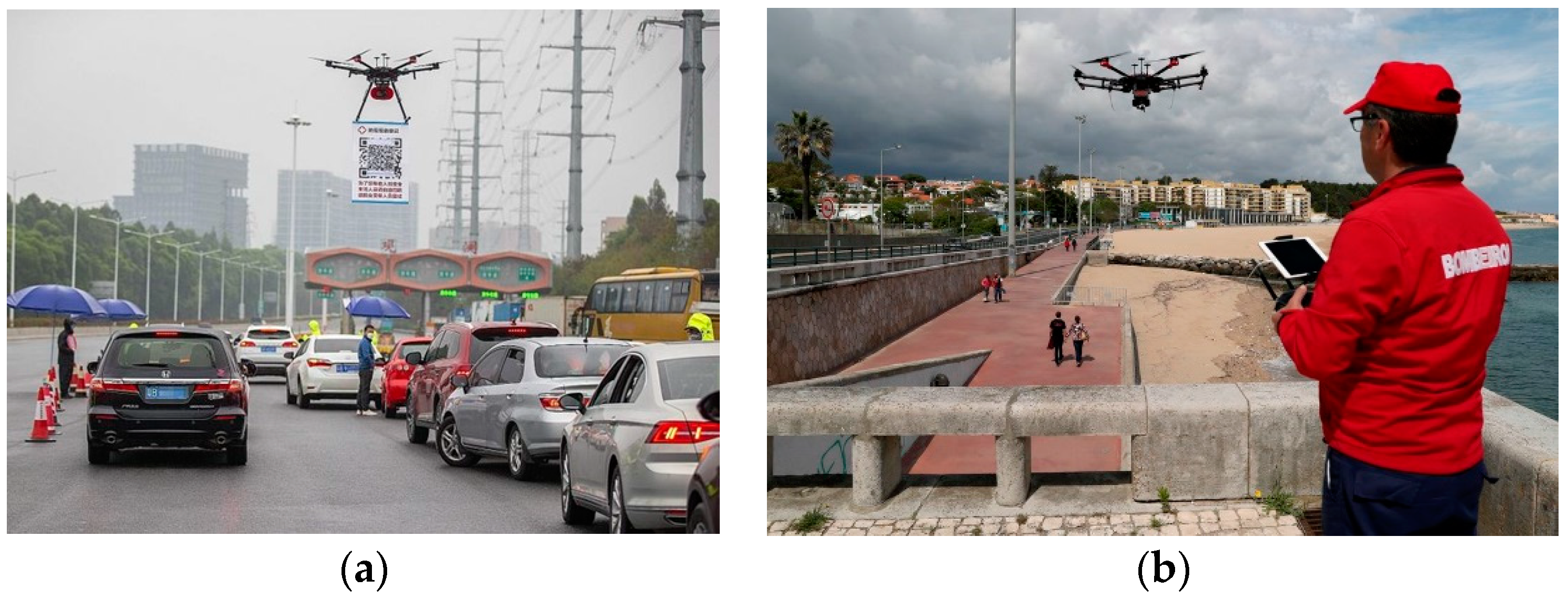
3.3. Using Loudspeaker on Board or Towing QR Code Flag for Communication
3.3.1. General Characteristics of Using Loudspeaker on Board
3.3.2. Analysis and Evaluation of Applied Practices
3.3.3. Requirements of Good Practice
3.3.4. Specialties of Towing QR Code Flag
3.3.5. Future Work Required to Improve the Present Practices
3.4. General Logistic Task
3.4.1. General Characteristics of Delivery Essentials Goods
3.4.2. Analysis and Evaluation of Applied Practices
3.4.3. Requirements of Good Practice
3.4.4. Future Work Required to Improve the Present Practices
3.5. Supporting Medical Services—Unique Logistic Task
3.5.1. General Characteristics of Supporting Medical Services
3.5.2. Analysis and Evaluation of Applied Practices
3.5.3. Requirements of Good Practice
3.5.4. Future Work Required to Improve the Present Practices
3.6. Drone Use for Spraying Disinfection
3.6.1. General Characteristics of Spraying Disinfection
3.6.2. Analysis and Evaluation of Applied Practices
3.6.3. Requirements of Good Practice
3.6.4. Future Work Required to Improve the Present Practices
4. Conclusions
Funding
Institutional Review Board Statement
Informed Consent Statement
Conflicts of Interest
References
- Goldman Sachs. Drones. Reporting for Work. Report of Goldman Sachs Research. 2020. Available online: https://www.goldmansachs.com/insights/technology-driving-innovation/drones/ (accessed on 10 May 2020).
- Chabot, D. Trends in drone research and applications as the Journal of Unmanned Vehicle Systems turns five. J. Unmanned Veh. Syst. 2018, 6, 6–15. [Google Scholar] [CrossRef] [Green Version]
- Cracknell, A.P. UAVs: Regulations and law enforcement. Int. J. Remote Sens. 2017, 38, 3054–3067. [Google Scholar] [CrossRef]
- Zwickle, A.; Farber, H.B.; Hamm, J.A. Comparing public concern and support for drone regulation to the current legal framework. Behav. Sci. 2018, 37, 109–127. [Google Scholar] [CrossRef] [Green Version]
- Tsiamis, N.; Efthymiouand, L.; Tsagarakis, K.P. A Comparative Analysis of the Legislation Evolution for Drone Use in OECD Countries. Drones 2019, 3, 75. [Google Scholar] [CrossRef] [Green Version]
- Hardin, P.J.; Hardin, T.J. Small-scale remotely piloted vehicles in environmental research. Geogr. Compass 2010, 4, 1297–1311. [Google Scholar] [CrossRef]
- Watts, A.C.; Ambrosia, V.G.; Hinkley, E.A. Unmanned aircraft systems in remote sensing and scientific research: Classification and considerations of use. Remote Sens. 2012, 4, 1671–1692. [Google Scholar] [CrossRef] [Green Version]
- Kardasz, P.; Doskocz, J.; Hejduk, M.; Wiejkut, P.; Zarzyck, H. Drones and Possibilities of Their Using. J. Civ. Environ. Eng. 2016, 6, 1–7. [Google Scholar] [CrossRef]
- Tang, L.; Shao, G. Drone remote sensing for forestry research and practices. J. For. Res. 2015, 26, 791–797. [Google Scholar] [CrossRef]
- Haidari, L.A.; Brown, S.T.; Ferguson, M.; Bancroft, E.; Spiker, M.; Wilcox, A.; Ambikapathi, R.; Sampath, V.; Connor, D.L.; Lee, B.Y. The economic and operational value of using drones to transport vaccines. Vaccine 2016, 34, 4062–4067. [Google Scholar] [CrossRef] [Green Version]
- Restas, A. Drone Applications for Supporting Disaster Management. World J. Eng. Technol. 2015, 3, 316–321. [Google Scholar] [CrossRef] [Green Version]
- Li, Y.; Liu, C. Applications of multirotor drone technologies in construction management. Int. J. Constr. Manag. 2019, 19, 401–412. [Google Scholar] [CrossRef]
- Amir, M.Y.; Abbass, V. Modeling of quadrotor helicopter dynamics, presentation. In Proceedings of the International Conference on Smart Manufacturing Application, KINTEX, Goyang City, Korea, 9–11 April 2008. [Google Scholar]
- Martin, G. Modelling and Control of the Parrot AR. Drone. J. Undergrad. Eng. Res. 2012, 5, 1–14. [Google Scholar]
- Kaleem, Z.; Rehmani, M.H. Amateur Drone Monitoring: State-of-the-Art Architectures, Key Enabling Technologies, and Future Research Directions. IEEE Wirel. Commun. 2018, 25, 150–159. [Google Scholar] [CrossRef] [Green Version]
- Agatz, N.; Bouman, P.; Schmidt, M. Optimization Approaches for the Traveling Salesman Problem with Drone. ERIM Report Series Research in Management. ERS-2015-011-LIS. Erasmus Research Institute of Management. 2016. Available online: https://repub.eur.nl/pub/78472 (accessed on 31 March 2021).
- Poikonen, S.; Wang, X.; Golden, B. The vehicle routing problem with drones: Extended models and connections. Netw. Int. J. 2017, 70, 34–43. [Google Scholar] [CrossRef]
- Restas, A. Path planning for autonomous vehicles. In Path Planning Optimization with Flexible Remote Sensing Application; Abdul Hamid, U.Z., Ed.; IntechOpen: London, UK, 2019. [Google Scholar] [CrossRef] [Green Version]
- Murray, C.C.; Chu, A.G. The flying sidekick traveling salesman problem: Optimization of drone-assisted parcel delivery. Transp. Res. Part C Emerg. Technol. 2015, 54, 86–109. [Google Scholar] [CrossRef]
- Bodnar, L.; Restas, A.; Qiang, X. Conceptual Approach of Measuring the Professional and Economic Effectiveness of Drone Applications Supporting Forest fire Management. Procedia Eng. 2018, 211, 8–17. [Google Scholar] [CrossRef]
- Shi, W.; Zhou, H.; Li, J.; Xu, W.; Zhang, N.; Shen, X. Drone Assisted Vehicular Networks: Architecture, Challenges and Opportunities. IEEE Netw. 2018, 32, 130–137. [Google Scholar] [CrossRef]
- Finn, R.L.; Wright, D. Unmanned aircraft systems: Surveillance, ethics and privacy in civil applications. Comput. Law Secur. Rev. 2012, 28, 184–194. [Google Scholar] [CrossRef]
- Restas, A.; Dudas, Z. Some aspect of human features of the use of unmanned aerial systems in a disaster-specific division. In Proceedings of the International Conference on Unmanned Aircraft Systems (ICUAS) Conference, Atlanta, GA, USA, 28–31 May 2013; pp. 1030–1036. [Google Scholar]
- Clarke, R. The regulation of civilian drones’ impacts on behavioral privacy. Comput. Law Secur. Rev. 2014, 30, 286–305. [Google Scholar] [CrossRef]
- Juniper, A. The Drone Pilot’s Handbook; Octopus Publishing: London, UK, 2010; ISBN 978 1 78157 378 5. [Google Scholar]
- Elliott, A. Build Your Own Drone Manual: The Practical Guide to Safely Building, Operating and Maintaining an Unmanned Aerial Vehicle (UAV); Haynes Publishing: Sparkford, UK, 2016; ISBN 978 0 85733 813 6. [Google Scholar]
- UN 2015. Study on Armed Unmanned Aerial Vehicles, Prepared on the Recommendation of the Advisory Board on Disarmament Matters. United Nations Publications. 2015. Available online: https://unoda-web.s3-accelerate.amazonaws.com/wp-content/uploads/assets/publications/more/drones-study/drones-study.pdf (accessed on 12 April 2021).
- UAV Coach 2020. How to Fly a Drone. A Beginner’s Guide to Multirotor Systems & Flight Proficiency. Available online: https://uavcoach.com/how-to-fly-a-quadcopter-guide/ (accessed on 20 May 2020).
- Mbunge, E.; Chitungo, I.; Dzinamarira, T. Unbundling the Significance of Cognitive Robots and Drones deployed to tackle COVID-19 pandemic: A rapid review to unpack emerging opportunities to improve healthcare in sub-Saharan Africa. Cogn. Robot. 2021, 1, 205–213. [Google Scholar] [CrossRef]
- Miranda, V.R.F.; Rezende, A.M.C.; Rocha, T.L.; Azpúrua, H.; Pimenta, L.C.A.; Freitas, G.M. Autonomous Navigation System for a Delivery Drone. J. Control. Autom. Electr. Syst. 2021, 2021. 33, 141–155. [Google Scholar] [CrossRef]
- Çetin-Kaya, Y.; Kaya, M.; Akdag, A. Route Optimization for Medication Delivery of Covid-19 Patients with Drones. J. Sci. Part C Des. Technol. 2021, 9, 478–491. Available online: https://dergipark.org.tr/tr/download/article-file/1744177 (accessed on 28 August 2021).
- Kunovjanek, M.; Wankmüller, C. Containing the COVID-19 pandemic with drones—Feasibility of a drone enabled back-up transport system. Transp. Policy 2021, 106, 141–152. [Google Scholar] [CrossRef]
- Alsarhan, A.; Almalkawi, I.T.; Kilani, Y. A New COVID-19 Tracing Approach using Machine Learning and Drones Enabled Wireless Network. Int. J. Interact. Mob. Technol. 2021, 15, 111–126. [Google Scholar] [CrossRef]
- Butt, U.J.; Richardson, W.; Abbod, M.; Agbo, H.M.; Eghan, C. The deployment of autonomous drones during the COVID-19 pandemic. In Cybersecurity, Privacy and Freedom Protection in the Connected World: Advanced Sciences and Technologies for Security Applications; Jahankhani, H., Jamal, A., Lawson, S., Eds.; Springer: Cham, Switzerland, 2021. [Google Scholar] [CrossRef]
- Vaishnavi, P.; Agnishwar, J.; Padmanathan, K.; Umashankar, S.; Preethika, T.; Annapoorani, S.; Subash, M.; Aruloli, K. Artificial Intelligence and Drones to Combat COVID-19. ResearchGate 2020. pre-print. [Google Scholar] [CrossRef]
- Kumar, A.; Sharma, K.; Singh, H.; Naugriya, S.G.; Gill, S.S.; Buyya, R. A drone-based networked system and methods for combating coronavirus disease (COVID-19) pandemic. Future Gener. Comput. Syst. 2021, 115, 1–19. [Google Scholar] [CrossRef]
- Kumar, A.; Elsersy, M.; Darwsih, A.; Hassanien, A.E. Drones combat COVID-19 epidemic: Innovating and monitoring approach. In Digital Transformation and Emerging Technologies for Fighting COVID-19 Pandemic: Innovative Approaches; Studies in Systems, Decision and Control; Springer: Cham, Switzerland, 2021; Volume 322, pp. 175–188. [Google Scholar] [CrossRef]
- Alsamhi, S.H.; Lee, B.; Guizani, M.; Kumar, N.; Qiao, Y.; Liu, X. Blockchain for decentralized multi-drone to combat COVID-19 and future pandemics: Framework and proposed solutions. Trans. Emerg. Telecommun. Technol. 2021, 32, e4255. [Google Scholar] [CrossRef]
- González-Jorge, H.; González-deSantos, L.M.; Fariñas-Álvarez, N.; Martínez-Sánchez, J.; Navarro-Medina, F. Operational Study of Drone Spraying Application for the Disinfection of Surfaces against the COVID-19 Pandemic. Drones 2021, 5, 18. [Google Scholar] [CrossRef]
- Restás, Á.; Szalkai, I.; Óvári, G. Drone Application for Spraying Disinfection Liquid Fighting against the COVID-19 Pandemic—Examining Drone-Related Parameters Influencing Effectiveness. Drones 2021, 5, 58. [Google Scholar] [CrossRef]
- WHO 2020. World Health Organization—Coronavirus Disease (COVID-19) Dashboard. Available online: https://covid19.who.int/ (accessed on 21 May 2020).
- Jackson, J.K.; Weiss, M.A.; Schwarzenberg, A.B.; Nelson, R.M. Global Economic Effects of COVID-19. Congressional Research Service, Report. 2020. Available online: https://fas.org/sgp/crs/row/R46270.pdf (accessed on 15 May 2020).
- Haleem, A.; Javaid, M.; Vaishya, R. Effects of COVID 19 pandemic in daily life. Curr. Med. Res. Pract. 2020, 10, 78. [Google Scholar] [CrossRef]
- Paramasivam, A.; Priyadharsini, J.V.; Raghunandhakumar, S.; Elumalai, P. A novel COVID-19 and its effects on cardiovascular disease. Hypertens. Res. 2020, 43, 729–730. [Google Scholar] [CrossRef]
- Taylor, L. COVID-19: Trial of experimental “covid cure” is among worst medical ethics violations in Brazil’s history, says regulator. BMJ Clin. Res. 2021, 375, n2819. [Google Scholar] [CrossRef]
- Nazar, F.A. COVID cure or perpetual vaccination? 30 cheap effective treatments of COVID-19 & variants, like ivermectin, or never-ending compulsory injection, with unsafe, genotoxic, infertilizing, injuring, crippling, handicapping, lethal, inefficient, ineffective, abortion-tainted, abortive, unethical, experimental genetic-hacks, deceivingly called vaccines instead of haccines? Scientific proof of the COVID with 1000 peer reviewed published references. Thesis Commons 2021, 1–166. [Google Scholar] [CrossRef]
- Carson, B. Social Media as a Research Methodology. Market Research. Available online: https://blog.marketresearch.com/social-media-as-a-research-methodology (accessed on 12 March 2021).
- Snelson, C.L. Qualitative and Mixed Methods Social Media Research: A Review of the Literature. Int. J. Qual. Methods 2016, 15, 1–15. [Google Scholar] [CrossRef] [Green Version]
- Brennen, B.S. Qualitative Research Methods for Media Studies, 3rd ed.; Routledge: London, UK, 2021. [Google Scholar] [CrossRef]
- Cohen, S.M.; Freeman, J.T.; Thompson, B.B. Integrated Critical Thinking Training and Decision Support for Tactical Anti-Air Warfare; Report, Contract No. N61339-96-R-0046; Naval Air Warfare Center Training System Division: Orlando, FL, USA; Cognitive Technologies, Inc.: Arlington, VA, USA, 1996. [Google Scholar]
- Torok, Z.; Ozunu, A.; Cordoş, E. Chemical Risk Analysis for Land Use Planning. I. Storage and Handling of Flammable Materials. Environ. Eng. Manag. J. 2011, 10, 81–88. [Google Scholar] [CrossRef]
- Gheorghiu, A.D.; Torok, Z.; Ozunu, A. How Can Existing Risk Assessment Methodologies Be Used in a Systematic Manner, in the Extractive Mining Industry? J. Environ. Prot. Ecol. 2013, 14, 1597–1607. [Google Scholar]
- Restas, A. Drone Applications for Preventing and Responding HAZMAT Disaster. World J. Eng. Technol. 2016, 4, 76–84. [Google Scholar] [CrossRef] [Green Version]
- Restas, A. Water Related Disaster Management Supported by Drone Applications. World J. Eng. Technol. 2018, 6, 116–126. [Google Scholar] [CrossRef] [Green Version]
- Radovic, M. Drones and the Coronavirus: From Crisis to Opportunity, Report, LinkdIn. 2020. Available online: https://www.linkedin.com/pulse/drones-coronavirus-from-crisis-opportunity-millie-radovic/ (accessed on 21 February 2021).
- Shivaramaiah, P. Drones Are Enabling Authorities to Implement an Effective COVID-19 Lockdown, Blog, CYENT. 2020. Available online: www.cyient.com/blog/drones-are-enabling-authorities-to-implement-an-effective-covid-19-lockdown (accessed on 20 February 2021).
- Bellman, R. Dynamic programming treatment of the travelling salesman problem. J. Assoc. Comp. Mach. 1962, 9, 61–63. [Google Scholar] [CrossRef]
- Malandraki, C.; Daskin, M.S. Time dependent vehicle routing problems: Formulations, properties and heuristic algorithms. Transp. Sci. 1992, 26, 185–200. [Google Scholar] [CrossRef]
- Applegate, D.L.; Bixby, R.E.; Chvatal, V.; Cook, W.J. The Traveling Salesman Problem: A Computational Study; Princeton University Press: Princeton, NJ, USA, 2011; ISBN 978 0 69112 993 8. [Google Scholar]
- Psaraftis, H.N. A dynamic programming solution to the single vehicle many-to-many immediate request dial-a-ride problem. Transp. Sci. 1980, 14, 130–154. [Google Scholar] [CrossRef]
- Mingozzi, A.; Bianco, L.; Ricciardelli, S. Dynamic programming strategies for the traveling salesman problem with time window and precedence constraints. Oper. Res. 1997, 45, 365–377. [Google Scholar] [CrossRef]
- Restas, A.; Hinkley, E.A.; Ambrosia, V.G. An approach for measuring the effectiveness of fire detection systems in different dimensions. Bolyai Szle. 2014, 23, 283–296. [Google Scholar]
- Video Report. Drone Footage Shows the Empty Streets of Cities on Lockdown, EuroNews. 2020. Available online: https://www.euronews.com/2020/03/26/drone-footage-shows-the-empty-streets-of-europe-s-locked-down-cities (accessed on 10 May 2021).
- Video Report. Drones Used in Effort to Slow the Spread of COVID-19. CBS NEWS. 2020. Available online: https://www.cbsnews.com/news/coronavirus-drones-slow-spread-covid-19/ (accessed on 6 June 2021).
- Morton, C. Coronavirus Quarantine: A Look at Empty Streets, Highways and Bridges from Paris to Florida. Condé Nast Traveler Magazin. 2020. Available online: https://www.cntraveler.com/gallery/coronavirus-quarantine-a-look-at-empty-streets-highways-and-bridges-from-paris-to-florida (accessed on 24 April 2021).
- Weissman, N.; Byars, D. Watch Drone Video of Los Angeles as Coronavirus Shuts Down the City. The Washington Post. Drone Video. 2020. Available online: https://www.youtube.com/watch?reload=9&v=O51LOuQzROI (accessed on 21 April 2021).
- HVG Report. Empty Streets and Silent Roads—Drone Videos about the Cities under Quarantine. Heti Vilag Gazdasag. Drone Video Report. 2020. Available online: https://hvg.hu/tudomany/20200326_koronavirus_jarvany_dronvideo (accessed on 4 May 2021).
- Krikorian, D.H.; Jae-Shin, L.; Chock, T.M.; Harms, C. Isn’t That Spatial? Distance and Communication in a 2-D Virtual Environment. J. Comput.-Mediat. Commun. 2006, 5, JCMC541. [Google Scholar] [CrossRef]
- Vaes, K.; Stappers, P.J.; Standaert, A. Product-Related Stigma in Design. Designe Research Society. 2016. Available online: https://www.drs2016.org/444 (accessed on 12 May 2020).
- Hochreutiner, C. How Smarter AI-Powered Cameras Can Mitigate the Spread of Wuhan Novel Coronavirus (COVID-19), and What We’ve Learned from the SARS Outbreak 17 Years Prior. AnyConnevt Academy. 2020. Available online: https://anyconnect.com/blog/smart-thermal-cameras-wuhan-coronavirus# (accessed on 17 May 2020).
- IT Guide, IR-Based Fever Detection for Coronavirus, SARS. Ebola, InfraTec GmbH. 2020. Available online: https://www.infratec.eu/thermography/industries-applications/medicine/ir-based-health-measures/ (accessed on 30 April 2020).
- FLIR Systems, Inc. Flir Guide, Thermal Imaging for Detecting Elevated Body Temperature. 2020. Available online: https://www.flir.com/discover/public-safety/thermal-imaging-for-detecting-elevated-body-temperature/ (accessed on 7 May 2020).
- Captain, S. Draganfly Is Developing a ‘Pandemic Drone’ to Help Fight COVID-19, DroneDJ, Report. 2020. Available online: https://dronedj.com/2020/04/13/draganfly-developing-pandemic-drone-covid-19/ (accessed on 14 May 2021).
- Report Xinhua. Coronavirus Control: Drones with Thermal Imaging Technology Adopted in Central China. Xinhua News. 2020. Available online: http://www.xinhuanet.com/english/2020-02/16/c_138788719.htm (accessed on 17 May 2021).
- Kenya Red Cross, Social Media Report, Twitter. 2020. Available online: https://twitter.com/KenyaRedCross/status/1250832389166829571 (accessed on 6 May 2021).
- Novak, M. Police Deploy ‘Pandemic Drone’ to Detect Fevers and Enforce Social Distancing. Gizmodo News. 2020. Available online: https://gizmodo.com/police-deploy-pandemic-drone-to-detect-fevers-and-enfor-1843017443 (accessed on 6 May 2021).
- Kimery, A. ’Pandemic Drone’ Tests to Monitor for COVID-19 Infections Ends Quickly Due to Privacy Concerns. Biometric Update, Report. 2020. Available online: https://www.biometricupdate.com/202004/pandemic-drone-tests-to-monitor-for-covid-19-infections-ends-quickly-due-to-privacy-concerns (accessed on 17 May 2021).
- Naar, I. Coronavirus: Thermal Drones Monitor Body Temperatures in Saudi Arabia’s Qassim. Al Arabiya News. 2020. Available online: https://english.alarabiya.net/en/life-style/healthy-living/2020/03/29/Coronavirus-Thermal-drones-monitor-body-temperatures-in-Saudi-Arabia-s-Qassim (accessed on 17 May 2021).
- Ng, E.Y.K.; Kaw, J.L.; Chang, W.M. Analysis of IR thermal imager for mass blind fever screening. Microvasc. Res. 2004, 68, 104–109. [Google Scholar] [CrossRef] [PubMed]
- Khanam, F.T.Z.; Al-Naji, A.A.; Chahl, J. Remote Monitoring of Vital Signs in Diverse Non-Clinical and Clinical Scenarios Using Computer Vision Systems: A Review. Appl. Sci. 2019, 9, 4474. [Google Scholar] [CrossRef] [Green Version]
- Hall, J. Can Thermal Imaging Take the Heat out of the Coronavirus Crisis? IFSEC Global. 2020. Available online: https://www.ifsecglobal.com/global/thermal-imaging-coronavirus-crisis/ (accessed on 24 May 2020).
- DH Report. COVID-19: IIT Alumni Develop Drone with Infrared Camera for Thermal Screening. Deccan Herald. 2020. Available online: https://www.deccanherald.com/national/covid-19-iit-alumni-develop-drone-with-infrared-camera-for-thermal-screening-820801.html (accessed on 26 April 2021).
- We Robotics. Drones and the Coronavirus: Do These Applications Make Sense? We Robotics, Report. 2020. Available online: https://blog.werobotics.org/2020/04/09/drones-coronavirus-no-sense/ (accessed on 13 May 2020).
- Honovich, J.; Rollet, C. Faked Coronavirus Fever Detection. Athena Used Hikvision, IPVM Report. 2020. Available online: https://ipvm.com/reports/faked-corona?code=allow (accessed on 21 May 2021).
- Jackson, A. How Drones Can Be Used to Detect Temperature and Fight COVID-19, Report, RocketMine. 2020. Available online: https://www.rocketmine.com/how-drones-can-be-used-to-detect-temperature-and-fight-covid-19/ (accessed on 12 January 2021).
- Daza, M.; Barrios-Aranibar, D.; Diaz-Amado, J.; Cardinale, Y.; Vilasboas, J. An Approach of Social Navigation Based on Proxemics for Crowded Environments of Humans and Robots. Micromachines 2021, 12, 193. [Google Scholar] [CrossRef]
- Hoshiba, K.; Washizaki, K.; Wakabayashi, M.; Ishiki, T.; Kumon, M.; Bando, Y.; Gabriel, D.; Nakadai, K.; Okuno, H.G. Design of UAV-Embedded Microphone Array System for Sound Source Localization in Outdoor Environments. Sensors 2017, 17, 2535. [Google Scholar] [CrossRef] [Green Version]
- Deleforge, A.; Di Carlo, D.; Strauss, M.; Serizel, R.; Marcenaro, L. Audio-Based Search and Rescue with a Drone: Highlights from the IEEE Signal Processing Cup 2019 Student Competition. IEEE Signal Processing Mag. 2019, 36, 138–144. [Google Scholar] [CrossRef] [Green Version]
- DJI Product Specification, The Powerful Everyday Tool for Professionals Ready to Put Drones To Work. DJI Unveils Mavic 2 Enterprise, M2E Speaker. 2018. Available online: www.dji.com/newsroom/news/dji-mavic-2-enterprise (accessed on 10 April 2020).
- HSE Product Specification, Drone Speaker, HSE-Unmanned Aerial Vehicle. 2018. Available online: https://hse-uav.com/product/drone-speaker/ (accessed on 19 April 2020).
- HK iFLY Product Specification, UAV Megaphone and Drone Speaker for Real-Time Speaking Broadcast and SD Card Audio File Display, HK Ifly. 2019. Available online: https://www.hk-ifly.com/ (accessed on 20 May 2020).
- Dixit, J. Corona Lockdown: 55 Drone Pilots Assigned for Strict Surveillance in Mumbai. ABP UNCUT, Report. 2020. Available online: https://news.abplive.com/uncut/insight-with-jitendra-dixit/corona-lockdown-55-drone-pilots-assigned-for-strict-surveillance-in-mumbai-abp-uncut-1194621 (accessed on 11 May 2020).
- Greenwood, F. The Dawn of the Shout Drone. SLATE, Journal, Report. 2020. Available online: https://slate.com/technology/2020/04/coronavirus-shout-drone-police-surveillance.html (accessed on 17 May 2020).
- Lu, D. China Is Using Mass Surveillance Tech to Fight New Coronavirus Spread. Report, NewScientist. 2020. Available online: https://www.newscientist.com/article/mg24532703-600-china-is-using-mass-surveillance-tech-to-fight-new-coronavirus-spread/ (accessed on 16 December 2020).
- Fiuza, P. Portugal Starts Using Talking Drones to Tell People to Stay at Home. Xinhua Net. 2020. Available online: http://www.xinhuanet.com/english/2020-04/28/c_139015558.htm (accessed on 20 May 2020).
- Drones Used to Prevent Spread of New Coronavirus in China. France24. 2020. Available online: https://www.france24.com/en/video/20200203-drones-used-to-prevent-spread-of-new-coronavirus-in-china (accessed on 12 May 2021).
- Troudi, A.; Addouche, S.A.; Dellagi, S.; El Mhamedi, A. Logistics Support Approach for Drone Delivery Fleet. Int. Conf. Smart Cities 2017, 86–96. [Google Scholar] [CrossRef]
- Sudbury, W.E.; Hutchinson, E.B. A Cost Analysis of Amazon Prime Air (drone Delivery). J. Econ. Educ. 2016, 16, 1–2. [Google Scholar]
- Tavares, T. Comparing the Cost-Effectiveness of Drones V Ground Vehicles for Medical, Food and Parcel Deliveries. Unmanned Airspace. 2021. Available online: https://www.unmannedairspace.info/commentary/comparing-the-cost-effectiveness-of-drones-v-ground-vehicles-for-medical-food-and-parcel-deliveries/ (accessed on 16 August 2021).
- Ueland, S. 8 Commercial Drone Delivery Companies. PracticalEcommerce. 2021. Available online: https://www.practicalecommerce.com/8-commercial-drone-delivery-companies (accessed on 28 August 2021).
- Wolf, H. We’re About to See the Golden Age of Drone Delivery—Here’s Why. World Economic Forum, Forbes. 2020. Available online: https://www.weforum.org/agenda/2020/07/golden-age-drone-delivery-covid-19-coronavirus-pandemic-technology/ (accessed on 22 July 2021).
- Ponza, A. Optimization of Drone-Assisted Parcel Delivery. MSc Thesis, University of Padova, Padova, Italy, 2016. [Google Scholar] [CrossRef]
- Benowitz, D. The Post-Pandemic Future of the Drone Industry, DroneAnalyst. 2020. Available online: https://droneanalyst.com/2020/09/17/covid-19-drives-interest-in-consumer-drones (accessed on 31 March 2021).
- Greenwood, F. Assessing the Impact of Drones in the Global COVID Response. TechStream. 2021. Available online: https://www.brookings.edu/techstream/assessing-the-impact-of-drones-in-the-global-covid-response/ (accessed on 28 August 2021).
- Bresnahan, S. The Good Drones: Air Delivery of Blood Samples Could Save Lives. CNN, Report. 2016. Available online: https://edition.cnn.com/2016/02/19/health/drones-deliver-healthcare-samples/index.html (accessed on 14 April 2020).
- Knight, R. Drones Deliver Healthcare. Inside Unmanned Systems, Autonomous Media. LLC, Report. 2016. Available online: https://insideunmannedsystems.com/drones-deliver-healthcare/ (accessed on 10 May 2020).
- Baker, A. The American Drones Saving Lives in Rwanda. Time, Report. 2017. Available online: https://time.com/rwanda-drones-zipline/ (accessed on 26 February 2020).
- Germann, J.; Lapijover, Y.; Marullaz, A.; Meier, P.; Nilius, F.; Perez, O.; Almonte, J.; Jiménez, F.; De la Cruz, J. Field-Testing Cargo Drones for Medicine Deliveries in Rural Environments of the Dominican Republic. We Robotics Flying Labs, Study. 2019. Available online: https://blog.werobotics.org/wp-content/uploads/2018/08/WeRobotics-Cargo-Drone-Field-Testing-in-the-Dominican-Republic-FINAL.pdf (accessed on 8 May 2020).
- Tucker, J. A Role for Drones in Healthcare. Hospital Impact, Report. 2020. Available online: https://www.dronesinhealthcare.com/ (accessed on 12 May 2020).
- Meier, P. Humanitarian Drone/UAV Missions: Towards Best Practices. WeRobotics Humanitarian UAV Network. Study. 2020. Available online: https://docs.google.com/document/d/1xyjOBVe4cz7F-Ed1lGzeT4ZPmC2tJ0JiDUyzWo1Ci9U/edit# (accessed on 10 May 2020).
- Guy, J. Your Medical Supplies Could Soon Arrive by Drone. CNNHealth. 2018. Available online: https://edition.cnn.com/2018/12/21/health/medical-transport-drones-scli-intl/index.html (accessed on 16 February 2021).
- Zhen, L.; Yunfeng, T. New Technologies Help China Fight Novel Coronavirus Epidemic. People’s Daily Overseas Edition. 2020. Available online: https://en.people.cn/n3/2020/0214/c90000-9657575.html (accessed on 17 April 2020).
- Martins, B.O.; Lavallée, C.; Silkoset, A. Drone Use for COVID-19 Related Problems: Techno-solutionism and its Societal Implications. Glob. Policy 2021, 12, 603–612. [Google Scholar] [CrossRef] [PubMed]
- Meier, P. Buzzkill: Why the Hype around Drones and COVID-19 Is Misplaced. World Economic Forum. 2020. Available online: https://www.weforum.org/agenda/2020/06/buzzkill-hype-drones-covid-19/ (accessed on 10 September 2021).
- Kumar, K.S.; Chen, P.-Y.; Ren, H. A Review of Printable Flexible and Stretchable Tactile Sensors. Research 2019, 32, 3018568. [Google Scholar] [CrossRef] [Green Version]
- MAR Commercial Drone Market Size, Share & Trends Analysis Report by Application (Filming & Photography, Inspection & Maintenance), by Product (Fixed-Wing, Rotary Blade Hybrid), by End Use, and Segment Forecasts, 2019–2025. Market Analysis Report. Grand View Research. 2019. Available online: https://www.grandviewresearch.com/industry-analysis/global-commercial-drones-market (accessed on 3 March 2020).
- BII Drone Market Outlook: Industry Growth Trends, Market Stats and Forecast. Business Insider Intelligence, Report. 2020. Available online: https://www.businessinsider.com/drone-industry-analysis-market-trends-growth-forecasts (accessed on 22 April 2020).
- DJI Report, DJI Helps Fight Coronavirus with Drones, DJI, Report. 2020. Available online: https://content.dji.com/dji-helps-fight-coronavirus-with-drones/ (accessed on 12 May 2020).
- TTA Report. Chinese TTA Drones Corona Virus Control Solution. TTA Report. 2020. Available online: https://www.ttaviation.org/news/chinese-drone-manufacture-tta-released-corona-virus-control-solution-on-umex-2020 (accessed on 12 May 2020).
- XAG Report. The Ultimate Agricultural Drone. XAG XPlanet Agricultural UAS. Report. 2020. Available online: https://www.xa.com/en/xp2020 (accessed on 12 May 2020).
Publisher’s Note: MDPI stays neutral with regard to jurisdictional claims in published maps and institutional affiliations. |
© 2022 by the author. Licensee MDPI, Basel, Switzerland. This article is an open access article distributed under the terms and conditions of the Creative Commons Attribution (CC BY) license (https://creativecommons.org/licenses/by/4.0/).
Share and Cite
Restás, Á. Drone Applications Fighting COVID-19 Pandemic—Towards Good Practices. Drones 2022, 6, 15. https://doi.org/10.3390/drones6010015
Restás Á. Drone Applications Fighting COVID-19 Pandemic—Towards Good Practices. Drones. 2022; 6(1):15. https://doi.org/10.3390/drones6010015
Chicago/Turabian StyleRestás, Ágoston. 2022. "Drone Applications Fighting COVID-19 Pandemic—Towards Good Practices" Drones 6, no. 1: 15. https://doi.org/10.3390/drones6010015
APA StyleRestás, Á. (2022). Drone Applications Fighting COVID-19 Pandemic—Towards Good Practices. Drones, 6(1), 15. https://doi.org/10.3390/drones6010015