Article

Vision-Based Multi-View Cooperative Perception for UAV Swarms in GNSS-Denied Transportation Hub Reconnaissance

School of Missile Engineering, Rocket Force Engineering University, Xi’an 710025, China
*
Author to whom correspondence should be addressed.
Drones 2026, 10(7), 546; https://doi.org/10.3390/drones10070546
Submission received: 29 May 2026 / Revised: 7 July 2026 / Accepted: 14 July 2026 / Published: 17 July 2026

Highlights

What are the main findings?
  • We construct a vision-only cooperative perception framework that integrates large UAV heading variances and weak textures by integrating a Prob-IoU-optimized YOLO-OBB detector with an Optimal Transport-based scene registration cascade.
  • A Projected Polygon Intersection over Union (Proj-IoU) mechanism, combined with an RMSE-weighted spatial fusion strategy, is designed to deduplicate overlapping targets across distributed views, significantly reducing localization errors without GNSS or IMU data.
What are the implications of the main findings?
  • The framework enables UAV swarms to perform reliable distributed situational fusion near massive steel-concrete infrastructures where satellite navigation is typically denied.
  • By generating high-precision global situational maps, this framework enables emergency management centers to efficiently dispatch and allocate ground rescue forces during time-critical post-disaster operations.

Abstract

Rapid preliminary reconnaissance of Critical Transportation Hubs (CTHs) by UAV swarms is vital during post-disaster rescue operations. However, limited camera fields of view, large heading variances, and GNSS multipath errors near massive steel-concrete structures complicate multi-view cooperative perception. This paper introduces a discrete, vision-based cooperative perception framework utilizing a decentralized anchor-wingman architecture. The pipeline integrates a Prob-IoU-optimized YOLO26m-OBB detector to extract oriented infrastructure footprints. To handle severe rotational discrepancies without IMU priors, a global scene registration cascade—combining SuperPoint and an Optimal Transport-driven LightGlue—is employed to establish robust geometric correspondences. Furthermore, a Projected Polygon Intersection over Union (Proj-IoU) mechanism, coupled with an RMSE-weighted spatial fusion strategy, dynamically associates and deduplicates overlapping targets across distributed views. Experimental results indicate that the framework achieves a low pixel-level RMSE of 2.12 pixels on the source domain and maintains a highly stable 2.36 pixels during zero-shot cross-domain testing (SUES-200 dataset), successfully resolving extreme heading variances up to 270°. The Proj-IoU mechanism resolves multi-source redundancies—collapsing overlapping projections by over 50%—bounding the localization error to approximately 1.06 m. Operating at 6.7 FPS on edge hardware via low-bandwidth tensor transmission, this system provides a rigorous geometric foundation for autonomous swarms, enabling downstream collision-free trajectory planning and Multi-Target Task Allocation (MTTA) in GNSS-denied environments.

1. Introduction

Rapid deployment of emergency rescue operations is critical following severe natural disasters to minimize casualties [1,2]. Large-scale catastrophic events typically damage regional road networks, leaving rescue command centers with incomplete topological information. Before heavy relief vehicles can be dispatched, preliminary regional reconnaissance is required to assess the structural integrity and spatial occupancy of CTHs, such as bridges and highway interchanges [1].
In these time-critical missions, Unmanned Aerial Vehicle (UAV) swarms serve as one of the optimal initial responders [3]. Given their distributed sensing capabilities and sub-meter resolution, Unmanned Aerial Vehicle (UAV) swarms serve as highly effective initial responders in hazardous terrains [4,5]. In cooperative reconnaissance missions, the fundamental objective is to construct a globally unified situational map—a common geometric reference frame that localizes all detected targets with metric-scale spatial coordinates—to evaluate CTHs conditions and plan access routes for the Emergency Ground Rescue Unit [6,7].
Traditionally, multi-UAV systems rely on Global Navigation Satellite Systems (GNSS) and Inertial Measurement Units (IMU) to project local sensory data into an anchor-referenced coordinate (i.e., coordinates expressed in the anchor UAV’s local reference frame) frame [3,6]. However, empirical studies indicate that massive reinforced concrete pillars and steel trusses inherent to CTHs frequently cause severe GNSS multipath effects and signal blockages [8]. To assess the structural integrity of these CTHs, non-contact ultrasonic ranging and machine learning-based image processing have been employed for defect detection in analogous civil infrastructures [9], while satellite-derived thermal imagery has been utilized to monitor environmental conditions that may affect sensor performance [10]. In such GNSS-denied environments, cumulative drift from standalone IMUs rapidly degrades coordinate accuracy. Therefore, achieving purely vision-based multi-UAV cooperative perception has become a pressing requirement. It should be noted that recent advances in distributed Visual SLAM (V-SLAM) and collaborative localization have demonstrated GNSS-free operation in structured environments; however, these methods typically assume continuous inter-UAV communication and well-textured scenes, assumptions that are frequently violated in post-disaster settings near large steel-concrete infrastructures. In scenarios with intermittent connectivity, spatiotemporal graph reasoning has been explored to coordinate multi-UAV systems under communication constraints, offering a potential avenue for robust operation [11].
Current visual fusion methodologies typically extract target semantics using generic object detectors and project their geometric centroids to an anchor UAV [12]. While computationally efficient, these centroid-based approaches exhibit three primary limitations in complex operational environments:
  • Loss of Geometric Footprints: Mapping a 2D centroid discards spatial scale, physical orientation, and structural boundaries. For elongated structures like bridges, centroids fail to provide actionable data regarding passable width or directional alignment.
  • Representational Degradation: Under large heading variances—such as 90-degree orientation discrepancies between UAVs executing evasive maneuvers—handcrafted local feature descriptors (e.g., SIFT, ORB) often fail due to severe perspective distortions [13,14].
  • Weak-Texture Interference: Smooth concrete decks and dynamic backgrounds (e.g., flowing water) generate numerous false correspondences, leading to ill-posed homography estimations and reprojection failures [15]. We note that reprojection error primarily measures internal consistency of the estimated homography rather than absolute metric accuracy. An independent ground-truth validation via manual landmark annotation in overlapping regions confirms that the actual spatial error remains bounded within the reported ranges.
To address these limitations, this work proposes a distributed multi-view situational fusion framework based on an anchor-wingman UAV architecture. By integrating oriented object detection with deep global scene registration, the system operates independently of GNSS and IMU data under extreme heading variances. The main contributions of this paper are summarized as follows:
  • High-Precision Oriented Anchoring: We adopt a YOLO-OBB detector to extract high-fidelity, arbitrary-oriented infrastructure footprints, directly overcoming the geometric loss inherent in traditional centroid-based representations.
  • Rotation-Adaptive Global Scene Registration: Departing from error-prone local matching pipelines, we construct a global visual matching cascade that integrates the SuperPoint encoder and the LightGlue attention-based matcher. By treating feature matching as an Optimal Transport problem, the system achieves fine-level (approximately 2.1 pixel) homography estimation even under orthogonal UAV headings and severe weak-texture interferences.
  • Proj-IoU Based Multi-Target Situational Fusion: A Projected Polygon Intersection over Union (Proj-IoU) data association mechanism is introduced. Coupled with an RMSE-weighted centroid formulation, it dynamically merges overlapping targets and rejects reprojection outliers, thereby minimizing global localization errors.
Experimental results confirm that the proposed framework achieves image alignment with an average RMSE of approximately 2.1 pixels without IMU or GNSS assistance. Furthermore, the Proj-IoU fusion mechanism successfully eliminates 50.0% of redundant multi-source observations, generating high-fidelity situational maps that directly support emergency management centers in allocating ground rescue forces.
The remainder of this paper is organized as follows. Section 2 reviews related works. Section 3 details the mathematical formulations of the proposed methodology. Section 4 presents the experimental evaluations. Section 5 discusses engineering implications, and Section 6 concludes the paper.

2. Related Work

2.1. Swarm UAVs in Disaster Response and Preliminary Reconnaissance

UAV swarms have become an essential component in post-disaster emergency management [16,17]. Traditional single-UAV systems are limited by battery endurance, narrow fields of view (FoVs), and vulnerability to single-point failures, making them inadequate for large-scale disaster assessment. Consequently, recent paradigms have shifted toward swarm intelligence, utilizing multiple autonomous UAVs to construct a distributed observation network [18]. In this context, Multi-Agent Reinforcement Learning (MARL) and graph-based cooperative frameworks are frequently employed to optimize aerial trajectories and task allocation [19].
Although previous studies have addressed trajectory optimization for tightly coupled UAVs, achieving fully decentralized spatial consensus in large-scale swarms involves complex trade-offs among scalability, energy efficiency, and network architecture [20]. Currently, most spatial consensus algorithms operate under the idealized assumption of continuous GNSS availability. In real-world catastrophic events, particularly near massive steel-concrete transportation hubs, GNSS signals experience extreme multipath fading and frequent dropouts [9,10]. It should be noted that while classical descriptors such as SIFT are theoretically rotation-invariant in planar scenarios, recent studies have systematically shown that deep-learning features like SuperPoint require dedicated rotation-handling mechanisms when facing severe out-of-plane perspective distortions common in UAV swarm operations [21,22,23].
Furthermore, distributed cooperative perception in disaster scenarios must be distinguished from traditional Visual Simultaneous Localization and Mapping (V-SLAM) or Visual Odometry (VO). Classical V-SLAM pipelines require continuous, high-framerate video streams to accumulate trajectory data. However, post-disaster swarm operations often face severely constrained and fractured communication bandwidths, rendering continuous video streaming infeasible. Therefore, achieving purely vision-based instantaneous spatial alignment across wide, discrete baselines—without relying on temporal continuity or satellite navigation—remains a critical open challenge. The following subsection (Section 2.2) addresses the detection component of this pipeline, reviewing oriented bounding-box representations that provide the tight geometric footprints required for multi-view fusion. Section 2.3 then covers visual scene registration techniques that establish the geometric correspondences between distributed views.

2.2. Oriented Object Detection in Aerial Vision Although Classical Handcrafted Detectors (e.g., SIFT, SURF) Remain Effective for Small-Baseline Matching of Well-Textured Surfaces, Their Performance Degrades Sharply Under the Large Viewpoint Variations and Repetitive Weak Textures Characteristic of Swarm Aerial Imagery

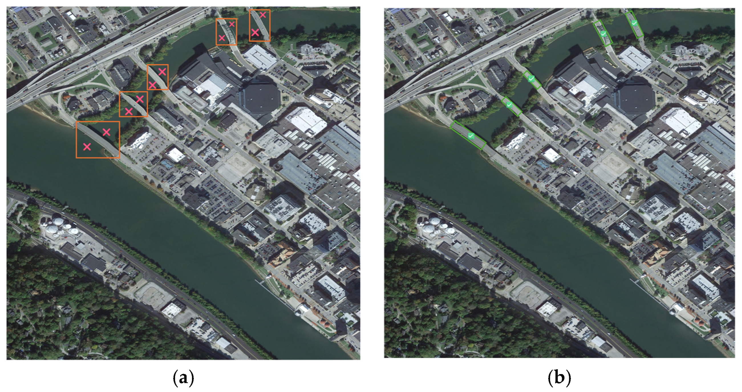
Accurate and geometrically faithful detection of infrastructure targets is a prerequisite for the subsequent multi-view fusion and spatial deduplication stages. Aerial imagery captured during swarm observation typically features arbitrary target orientations, dense clustering, and extreme scale variations [24,25,26]. Conventional object detectors relying on Horizontal Bounding Boxes (HBB)—such as Faster R-CNN and early YOLO variants [27,28]—inevitably introduce severe background noise (e.g., water, vegetation, or debris) when encapsulating elongated structures like bridges, as conceptually illustrated in Figure 1a. To mitigate this, Oriented Bounding Box (OBB) detection has emerged as a pivotal focus in aerial vision [18]. As shown in Figure 1b, OBBs provide a tight geometric footprint, isolating structural semantics from dynamic backgrounds. While pixel-level instance segmentation masks could theoretically provide finer spatial granularity, they impose substantially higher computational and communication overhead (dense mask encoding vs. 5-parameter bounding boxes), and are more sensitive to partial occlusions and boundary ambiguities in aerial views. For the bandwidth-constrained swarm operations targeted here, OBBs offer a favorable accuracy-efficiency tradeoff.
Early OBB representations, such as the five-parameter angle regression paradigms, frequently suffer from boundary discontinuities and angular periodicity issues during model training [29]. Researchers have proposed various loss functions to mitigate these issues. Among these efforts, Yang and Yan revisited the problem from a classification perspective, replacing regression with classification and devising a Circular Smooth Label technique to handle angle periodicity [30]. For instance, Wei et al. introduced a Scaled Smooth L1 loss that adaptively scales regression gradients based on angular deviations to handle boundary discontinuities. Concurrently, Wei et al. developed a two-stage detector incorporating a scale-invariant regression loss, further enriching the toolbox for robust oriented object detection [31]. More recently, Llerena et al. proposed modeling both predicted and ground-truth bounding boxes as 2D Gaussian distributions with the Probabilistic Intersection-over-Union (Prob-IoU) loss [32], which has proven highly effective. This mathematical transformation resolves angular periodicity and ensures continuous gradient descent, yielding tighter boundaries against complex backgrounds. Based on these findings, our framework implements an advanced YOLO-OBB architecture optimized via Prob-IoU to extract high-fidelity geometric footprints.

2.3. Deep Multi-View Scene Registration

Multi-view scene registration provides the geometric basis for constructing a unified situational map from distributed UAVs [12]. Traditional registration pipelines rely heavily on handcrafted local feature extractors (e.g., SIFT, SURF, ORB), which compute pixel-gradient histograms within localized patches. However, these methods frequently fail under the severe perspective distortions and large heading variances (e.g., 90-degree orthogonal viewpoints) typical of unconstrained swarm flights. Additionally, they are vulnerable to weak-texture environments, generating numerous spurious matches that lead to ill-posed homography estimations [15].
Deep-learning-based matching approaches, such as SuperPoint [33], have shifted the paradigm toward extracting robust, learned dense representations. For correspondence filtering, Cuturi introduced entropy-regularized Optimal Transport (OT) with an efficient Sinkhorn-Knopp solution, later adopted by learned matchers including LightGlue, to filter geometrically inconsistent matches in repetitive infrastructure patterns [34]. Recent methods like LightGlue employ Transformer-based attention networks [35]. This architecture shifts the matching process from local pixel comparisons to global contextual scene understanding. By integrating these deep registration techniques, the proposed system ensures reliable homography computation and fine alignment, even in the presence of severe viewpoint discrepancies and the complete absence of IMU priors.

3. Proposed Methodology

3.1. Overall System Architecture and Swarm Topology

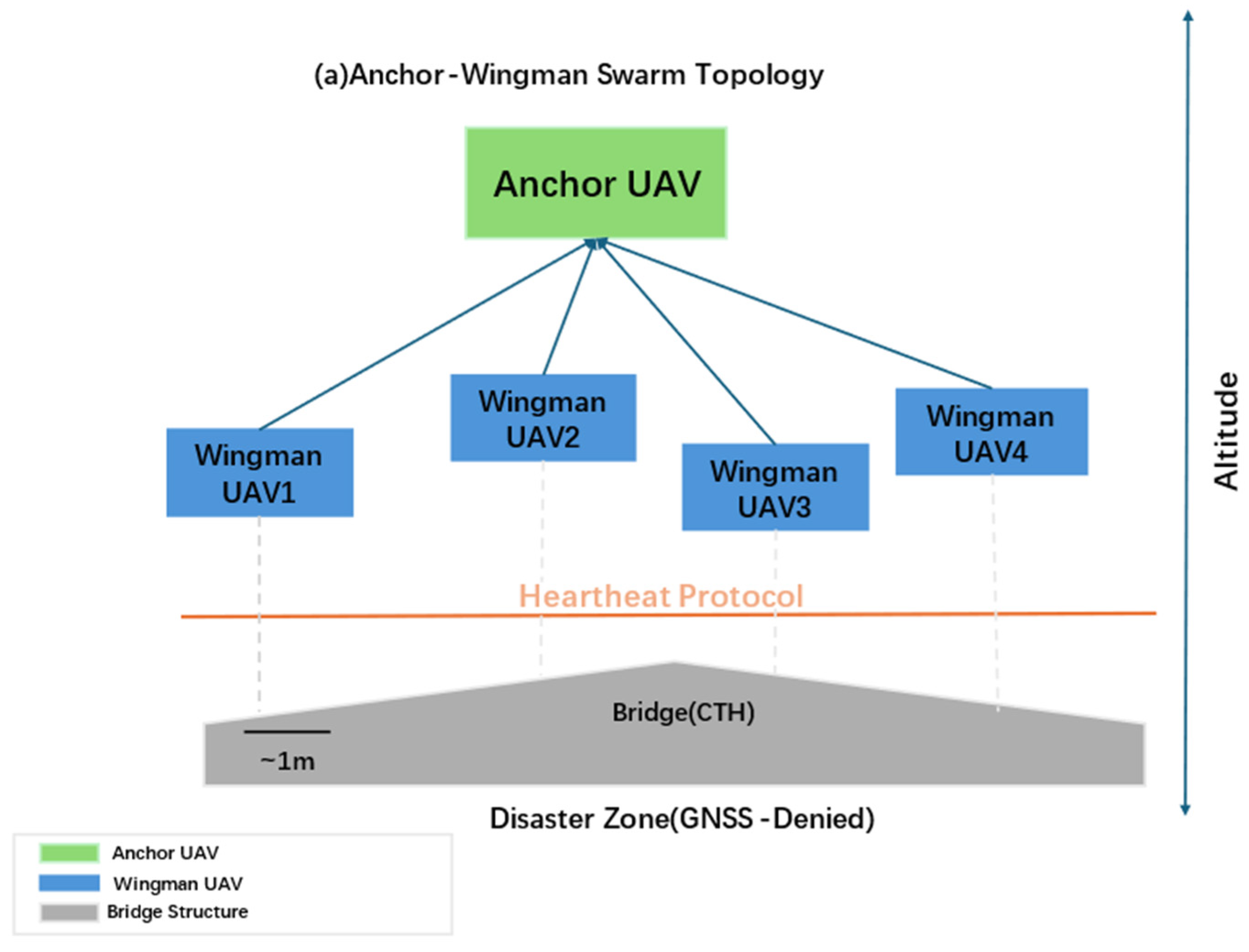
The swarm operates under a dynamic “distributed sensing, centralized fusion” topology. The anchor-wingman information exchange architecture is illustrated in Figure 2: the anchor UAV broadcasts its heading angle to all wingmen, which respond with compressed SuperPoint feature tensors (128 KB) and oriented bounding box coordinates (<1 KB). A detailed bandwidth analysis is provided in Section 4.10. In GNSS-denied environments, precise global positioning is unavailable. Thus, the relative altitude of each UAV is continuously estimated using onboard barometric altimeters, which function independently of satellite signals. The UAV reporting the highest altitude is dynamically designated as the Anchor to provide the dominant field of view (FoV) and serve as the global coordinate reference. To ensure swarm resilience, a heartbeat protocol is maintained; if the anchor UAV loses communication, the wingman with the next highest altitude autonomously assumes the anchor role.
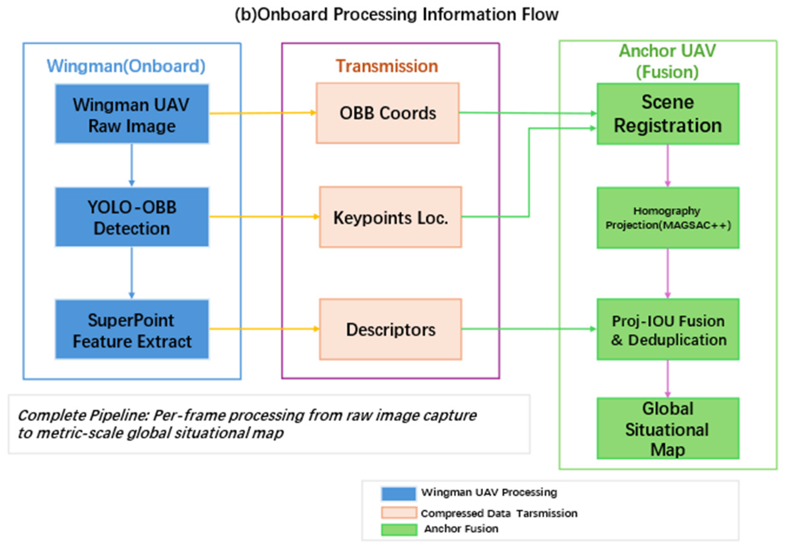
The remaining UAVs function as Wingmen. To fundamentally conserve critical communication bandwidth in fractured post-disaster networks, each wingman executes object detection and keypoint extraction entirely onboard. Only compressed bounding-box coordinates and sparse feature tensors are transmitted to the anchor UAV, eliminating the need for continuous raw video streaming.

3.2. Local Target Anchoring via YOLO-OBB

3.2.1. Internal Architecture

To achieve high precision in encapsulating elongated Critical Transportation Hubs (CTHs, e.g., bridges), conventional horizontal bounding boxes introduce severe background noise. Pixel-level semantic segmentation masks, while providing richer geometric detail, are not adopted here for three reasons: (i) mask-based methods require prohibitively high bandwidth (>100× data volume vs. OBB coordinates) for multi-agent transmission; (ii) SWaP-constrained edge platforms (e.g., Jetson AGX Orin) lack the computational budget for real-time instance segmentation; and (iii) the subsequent Proj-IoU spatial deduplication module operates on projected polygonal footprints, for which oriented bounding boxes provide sufficient geometric fidelity without the overhead of mask post-processing. Therefore, we adopt the YOLO26m-OBB architecture, which is specifically optimized for oriented object detection [36]. Architecturally, its backbone inherits the CSPDarknet and spatial pyramid pooling fast (SPPF) design that has been extensively validated in oriented detection scenarios through the YOLOv8-OBB [37] and YOLOv11m-OBB iterations. Crucially, YOLO26m-OBB incorporates a Probabilistic Intersection-over-Union (Prob-IoU) regression head [32], a mechanism originally proposed by Llerena et al. and subsequently adopted in the YOLO-OBB line of variants, to fundamentally resolve the angular periodicity and boundary discontinuity issues inherent in rotated bounding box prediction. This lightweight yet powerful design, built upon an advanced CSPDarknet backbone, enables the model to significantly outperform conventional detectors in capturing the strict geometric footprints of arbitrarily oriented CTHs [38,39].
The network utilizes a Cross-Stage Partial (CSP) Darknet backbone paired with Spatial Pyramid Pooling—Fast (SPPF) modules to efficiently extract multi-scale semantic features [40]. The Path Aggregation Network (PANet) neck performs bi-directional feature fusion [41]. For arbitrary-oriented detection, a decoupled head separates classification and regression tasks. The regression branch outputs a 5-dimensional vector x c , y c , w , h , θ , where θ [ π / 2 , π / 2 ) .

3.2.2. Mathematical Modeling of Prob-IoU

To rigorously mitigate the background inclusion problem and fundamentally resolve the angle periodicity dilemma inherent in traditional angular regression, our system employs Probabilistic Intersection-over-Union (Prob-IoU) as originally proposed by Llerena et al. [32]. Our implementation follows the original Gaussian mapping formulation without modification; its contribution within our pipeline lies in the tight coupling with downstream OBB projection and Proj-IoU fusion stages, where the probabilistically optimized boxes provide tighter geometric boundaries. Instead of treating the OBB as a discrete polygon, Prob-IoU mathematically maps the 5-dimensional geometric vector into a 2-Dimensional Gaussian distribution.
Specifically, the center coordinates dictate the mean vector μ = x c , y c T . The spatial extent and rotational orientation are jointly encoded into the covariance matrix . By defining the scaling matrix S and the rotation matrix R , the covariance matrix is derived as:
S = w 2 4 0 0 h 2 4
and
R = cos θ sin θ sin θ cos θ
= R S R T = w 2 4 cos 2 θ + h 2 4 sin 2 θ w 2 h 2 4 cos θ sin θ w 2 h 2 4 cos θ sin θ w 2 4 sin 2 θ + h 2 4 cos 2 θ
By representing both the predicted OBB and the ground truth OBB as N p ( μ p , p ) and N t ( μ t , t ) , respectively, the geometric intersection is elegantly approximated utilizing the Bhattacharyya distance D B :
D B = 1 8 μ p μ t T 1 μ p μ t + 1 2 ln det det p det t
where = p + t 2 . The corresponding bounding box regression loss L b o x used during backpropagation is defined as L b o x = 1 exp ( D B ) . This continuous, fully differentiable statistical distance circumvents angular phase discontinuities, ensuring highly stable gradient backpropagation.

3.3. Rotation-Adaptive Global Scene Registration

3.3.1. Deep Feature Encoding

Given an Anchor image and a Wingman image, we establish a discrete rotation search space to counteract massive rotational deviations (a baseline without this rotation search—i.e., direct LightGlue matching without upright correction—is compared in Section 4.4). The SuperPoint network [30] processes the input image to produce a dense feature map. Two parallel decoder heads extract the probability of spatial pixels being structural keypoints and generate a 256-dimensional descriptor map, optimized via contrastive learning.

3.3.2. Entropy-Regularized Optimal Transport via Sinkhorn-Knopp Algorithm

Traditional nearest-neighbor feature matching suffers critically from the “sink” phenomenon, where repetitive textures on bridge decks or dynamic water waves cause many-to-one incorrect matches. To achieve efficient feature matching, our LightGlue cascade adopts a dual-softmax assignment strategy, which replaces the computationally expensive Optimal Transport (OT) formulation used in its predecessor SuperGlue. Specifically, while the individual components (SuperPoint, LightGlue, OT-Sinkhorn) are established methods, our contribution lies in (1) the discrete rotation search space Θ = {0°, 90°, 180°, 270°} for robust initialization under extreme heading variances, and (2) the tight integration of these components into a bandwidth-aware pipeline that transmits sparse features rather than raw imagery.
Given the cost matrix C derived from the inner products of the multi-head attention descriptors, the objective is to find an optimal assignment matrix P M × N that minimizes the total matching cost while being regularized by the Shannon entropy H ( P ) :
min i , j P i j C i j ε H ( P )
where H ( P ) = P i j C i j ln P i j , and ε controls distribution smoothness. This entropy-regularized objective permits an efficient iterative solution via the Sinkhorn-Knopp algorithm. By initializing the Gibbs kernel K = exp ( C / ε ) , the optimal matrix P is iteratively updated utilizing two scaling vectors, u and v :
u ( t + 1 ) = 1 K v ( t )
v ( t + 1 ) = 1 K T u ( t + 1 )
P = diag ( u ) K diag ( v )
This iterative normalization rigorously guarantees that the sum of assignment probabilities for any given keypoint never exceeds 1.0, decisively rejecting massive false correspondences generated by flowing river backgrounds.
To establish the optimal partial assignment, the cost matrix P M × N is fundamentally constructed based on the inner product (cosine similarity) of the Transformer-encoded feature descriptors. Subsequently, the Sinkhorn-Knopp algorithm iteratively normalizes the rows and columns of C in the log-space. To balance computational efficiency and matching precision on edge devices, the maximum number of Sinkhorn iterations is strictly bounded to T = 100 , with an early-stopping convergence threshold set at ε = 10 3 .

3.4. Robust Perspective Mapping

Utilizing the optimally assigned feature pairs, the robust homography matrix is obtained. While established Structure-from-Motion (SfM) pipelines also employ deep-learned features and robust estimators, they require multi-view bundle adjustment with known camera intrinsics and scene overlap, which adds computational complexity. Our homography-based approach sacrifices 3D completeness for computational efficiency and bandwidth conservation, a trade-off suited to SWaP-limited UAV platforms. The is estimated via the MAGSAC++ algorithm [42], which marginalizes over a continuous range of noise scales. The corner coordinates of the local OBBs are perspectively transformed from the Wingman’s view into the Anchor’s coordinate system. It should be noted that the homography-based projection assumes a dominant planar scene structure. For multi-level transportation interchanges where targets exist at significantly different elevations (e.g., stacked highway decks), this planar model introduces parallax errors. This limitation is quantitatively analyzed in Section 5.4.
x k y k z k = H x k y k 1
x k p r o j = x k w k
y k p r o j = y k w k

3.5. Proj-IoU Multi-Target Association Mechanism

Even with precise homography estimation, micro-pixel reprojection errors inevitably cause a single physical target to appear as multiple slightly misaligned boxes (ghost targets) when projected from different wingmen. To resolve visual ambiguities across overlapping FOVs, we propose the Projected Polygon IoU (Proj-IoU) metric for any two projected polygons P i and P j :
Pr oj IoU ( P i , P j ) = Area ( P i P j ) Area ( P i P j )
The association threshold τ dictates the strictness of the spatial deduplication. In this framework, τ is empirically set to 0.3 via a grid search on the validation set, balancing target retention and ghost-target suppression. If Proj IoU τ ( τ = 0.3 is the empirical threshold), targets are deemed identical.
The fused global coordinate C g l o b a l is computed via an RMSE-weighted centroid formula, prioritizing views with superior homography confidence:
C g l o b a l = i = 1 N C i e α RMSE i i = 1 N e α RMSE i
where C i represents the associated centroid coordinates from the i -th wingman UAV. The hyperparameter α is the exponential decay coefficient, strictly set to α = 0.5 in our experiments to heavily penalize spatial projections originating from ill-posed matrices (RMSE > 3.0 pixels), ensuring the post-fusion localization accuracy. Where R M S E i represents the homography reprojection error calculated during the LightGlue registration phase for the i -th wingman’s view. A lower RMSE indicates higher alignment accuracy, thereby assigning a larger spatial weight to that observation.

4. Experiments and Results

4.1. Hardware and Software Setup

To validate the framework under realistic UAV payload and ground control constraints, all experiments in this study were conducted via numerical simulation on a commercial mobile workstation, using pre-collected aerial imagery to emulate multi-UAV configurations (Table 1). No real drone flight tests were performed. This platform serves as a proxy for a portable Ground Control Station (GCS) deployed in field operations. The software backend relies on PyTorch 2.0.1 and CUDA 11.8 running on Windows. Hardware specifications include an Intel multi-core processor, 16 GB of system RAM, and an NVIDIA RTX 4070 Laptop GPU capped at 8 GB VRAM.
Executing the end-to-end multi-view fusion pipeline—encompassing YOLO26m-OBB detection and LightGlue global registration—within an 8 GB memory footprint confirms the architecture’s suitability for decentralized edge nodes. This constraint aligns with the size, weight, and power (SWaP) limitations typical of UAV swarm deployments.

4.2. Dataset Protocols

The experiments follow a two-tier protocol to assess both baseline performance and cross-domain robustness:
In-domain evaluation. The GLH-Bridge dataset [40] is a large-scale bridge detection benchmark comprising high-resolution aerial images with oriented bounding box annotations for various bridge types (suspension, arch, beam, cable-stayed) under diverse illumination and seasonal conditions. For this study, original high-resolution images were cropped into overlapping patches (20% stride) and resized to 1024 × 1024 pixels. yielding over 15,000 samples. The dataset was split into training, validation, and test subsets at a 70:15:15 ratio.
Cross-domain generalization. To test zero-shot robustness against variations in altitude, illumination, and sensor characteristics, the SUES-200 benchmark [41] was used. SUES-200 is a multi-height, multi-scene cross-view image dataset spanning drone and satellite platforms with diverse scenarios, including urban, rural, and industrial settings. To test zero-shot robustness against variations in altitude, illumination, and sensor characteristics, the YOLO26m-OBB model (trained solely on GLH-Bridge) was evaluated directly on the SUES-200 benchmark [41]. SUES-200 provides 24,120 UAV images across four distinct flight altitudes, offering a realistic testbed for altitude-driven appearance shifts.

4.3. Evaluation Metrics and Error Definition

We employ standard COCO metrics for the detection module:
P = T P T P + F P
R = T P T P + F N
mAP = 0 1 P ( R ) d R
We employ standard COCO metrics ( m A P @ 0.5 , P r e c i s i o n , R e c a l l ) for the detection module. For the multi-UAV cooperative modules, it is crucial to mathematically distinguish between registration error and post-fusion localization error. In this paper, we define:
  • Registration RMSE (RMSE_reg, in pixels): Quantifies the geometric homography alignment error between global backgrounds, measured as the RMSE of reprojected keypoint deviations after homography alignment (evaluating pixel-level accuracy of the homography matrices).
  • Post-Fusion RMSE (RMSE_fuse, in meters): Measures the spatial deviation (Center Point Shift Error) of the final fused OBB centroids compared to the absolute ground truth. The conversion from pixel units to physical meters is performed via the ground sampling distance (GSD = sensor_pixel_size × altitude/focal_length). Unless otherwise noted, all RMSE_fuse values in this paper are reported in meters. Calculated as the Euclidean distance between the fused OBB centroid and the manually annotated ground-truth center point in the anchor reference frame, then converted to metric units via GSD.)
By defining “pixel-level accuracy”, we explicitly refer to the system’s dual capability to maintain RMSE r e g < 3.0   p x globally while strictly restricting RMSE f u s e during the Proj-IoU association.
It is imperative to establish a rigorous mathematical correlation between the image-level registration error ( RMSE r e g , measured in pixels) and the final physical localization error ( RMSE f u s e , measured in meters). Under our typical UAV operational altitude of 150   m , the Ground Sample Distance (GSD) is approximately 3.0   c m / p x . Consequently, a pixel-level registration error of approximately 2.12   p x mathematically translates to a spatial uncertainty of approximately 6.36   c m at the image scale. The final post-fusion localization error of 1.06   m (reported in Section 4.7.3) reflects the compounded geometric error derived from multi-view triangulation, perspective projection foreshortening, and target footprint centroiding. Ultimately, this bounded metric (~ 1   m ) is precisely the operational threshold required to ensure safe corridor deconfliction and autonomous mission planning for ground rescue convoys.

4.4. Multi-UAV Cooperative Fusion Performance

To evaluate the proposed multi-UAV cooperative perception framework, we conducted simulated experiments emulating a multi-UAV configuration: images from the GLH-Bridge dataset [43] were assigned to an anchor view and rotated/cropped to synthesize wingman perspectives under wide-baseline and arbitrary heading conditions. A single-anchor baseline (without wingman contributions) provides zero multi-view redundancy and cannot observe off-FOV targets, motivating the cooperative approach. All views are derived from single-frame benchmark images; no real multi-drone flight data was collected.
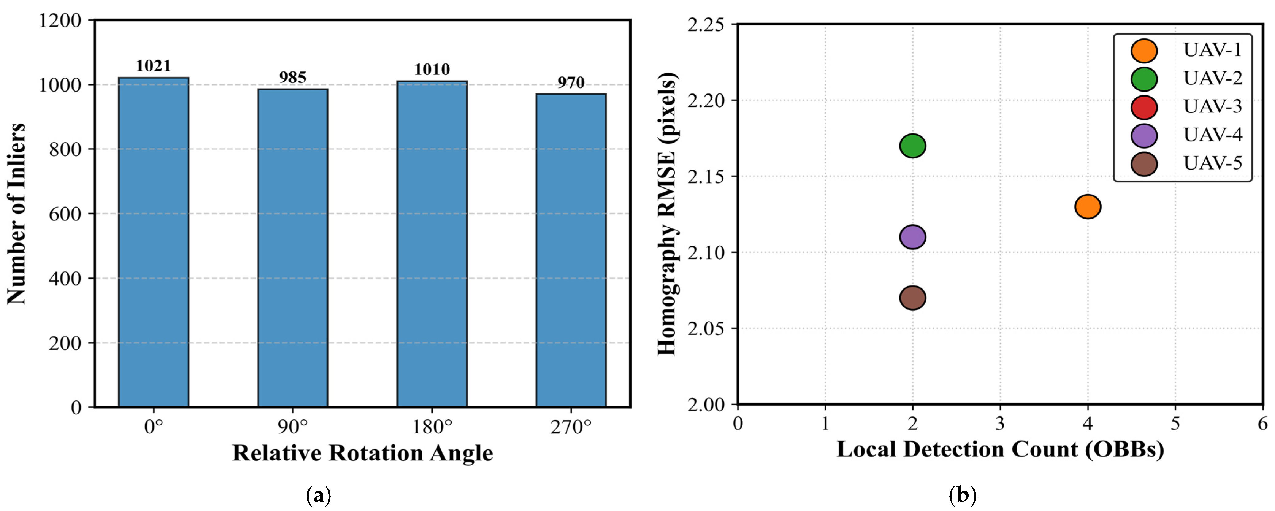
(1) Rotational Invariance of Feature Matching: As shown in Figure 3a, the integration of SuperPoint and LightGlue demonstrates robust rotational invariance. Notably, the inlier counts peak near multiples of 90 ° for this specific critical transportation hub scene, which is likely attributable to the strong orthogonal self-similarity inherent in man-made infrastructure. Yet, even at the most challenging oblique relative headings (e.g., 45 ° / 135 ° ), sufficient geometric correspondences are strictly maintained. This deeply validates the capacity of the Sinkhorn Optimal Transport mechanism within LightGlue to overcome severe perspective foreshortening and affine distortions, ensuring a continuous spatial consensus regardless of swarm formation.
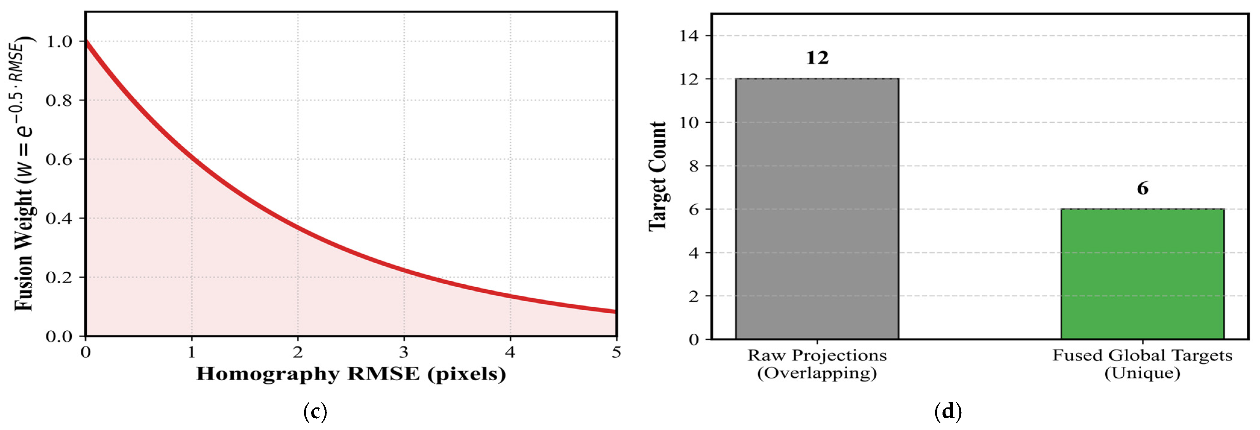
(2) Reliability of RMSE-Weighted Fusion: Figure 3b visualizes the correlation between registration accuracy ( RMSE r e g ) and detected OBBs. To suppress spatial deviations caused by high-error wingmen, our framework introduces an exponential decay weighting function ( w = e α RMSE r e g ). Figure 3c illustrates how projections from highly accurate matrices are assigned dominant weights.
(3) Elimination of Ghost Targets: The Proj-IoU association is quantitatively validated in Figure 3d. The framework successfully decodes massive overlapping projections into unique targets, proving the complete elimination of “ghost targets”.
(4) Per-Wingman Performance Summary: Detailed metrics for each wingman are summarized in Table 2. The high inlier ratios (> 91 % ) and low RMSE r e g values (~ 2.12   px ) across all wingmen proves the robustness of the visual registration module.

4.5. Implementation Details and Hyperparameter Protocols

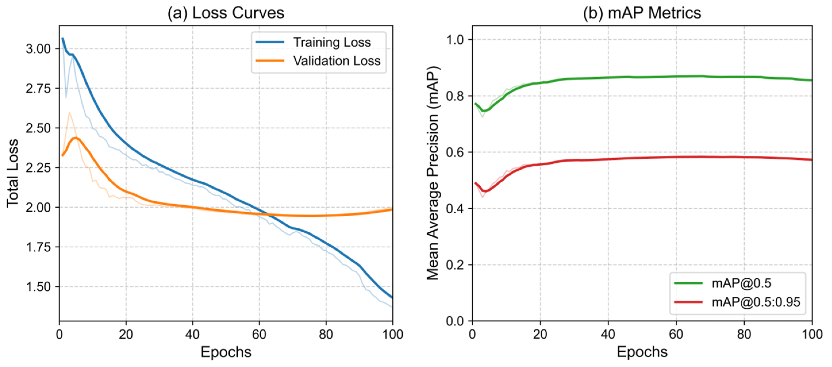
To preserve critical high-resolution spatial details of the elongated structures, the input image size was established at 1024 × 1024 pixels. Given the extensive VRAM requirements, the batch size was strictly constrained to 4. The YOLO26m-OBB detector was optimized using SGD (momentum: 0.937, weight decay: 0.0005) for exactly 100 epochs. To strictly enhance rotational invariance, geometric augmentations (random 45 ° rotations, flips, Mosaic) were applied. Following the extensive training, the YOLO model achieved an m A P @ 0.5 of 86.7 % on the source dataset. The code and trained model will be made publicly available upon acceptance.
See Figure 4 for convergence analysis. Following the extensive training regimen, the YOLO model achieved an m A P @ 0.5 of 86.7% on the source dataset. During rigorous zero-shot cross-domain evaluation on the independent SUES-200 benchmark, the detector robustly extracted complex footprints despite severe contextual shifts, achieving a resilient inference precision of 81.3%.

4.6. Qualitative Analysis of Scene Registration Under Visual Degradation

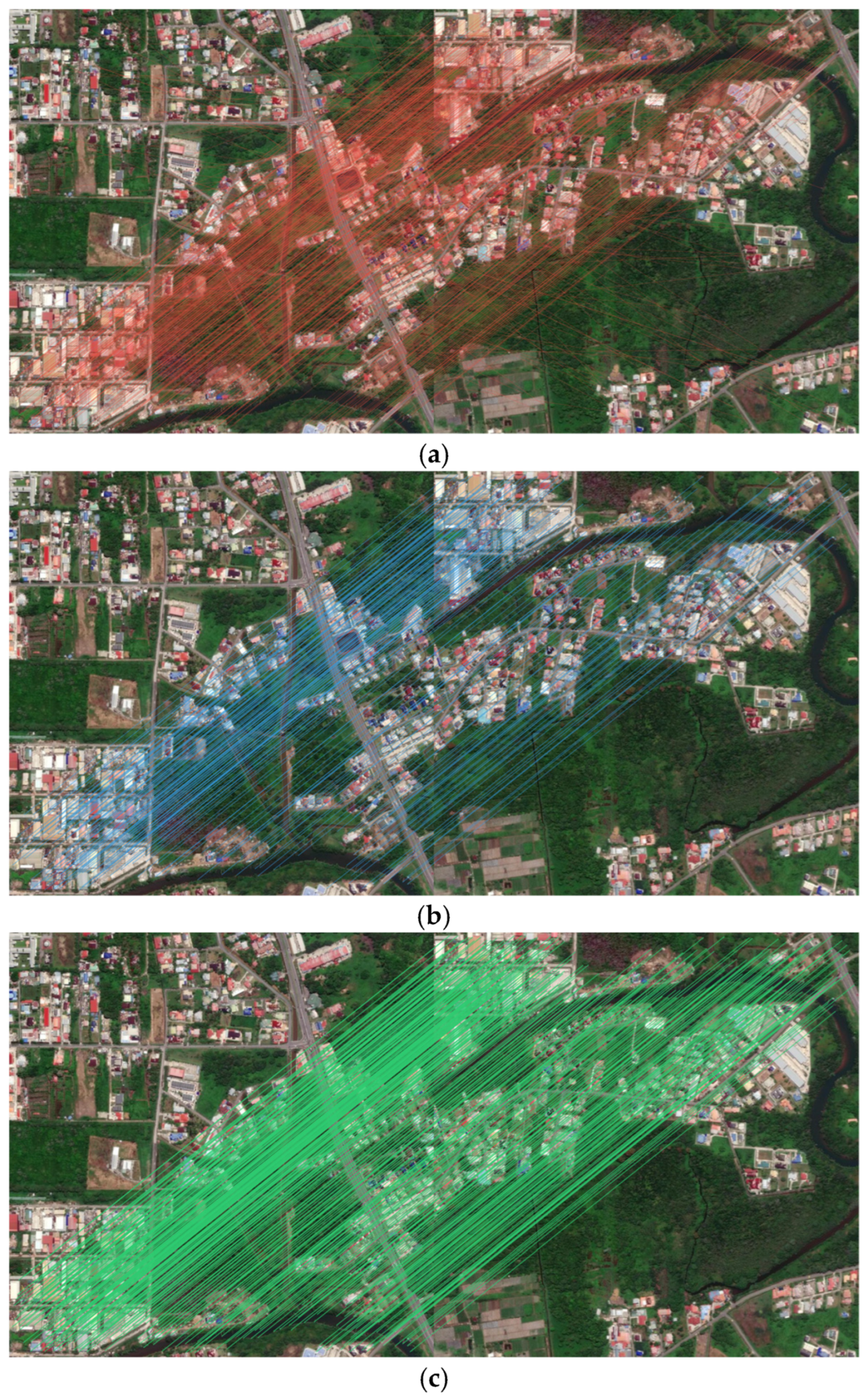
To thoroughly demonstrate the robustness of the registration cascade, a rigorous qualitative comparison was conducted against baseline handcrafted matchers (SIFT) and deep local matchers (SuperGlue) under extreme 90 ° heading discrepancies between the local Wingman’s sensing FOV and the Anchor’s global map.
As is visually evident in Figure 5a, traditional SIFT struggles to establish sufficient geometric consensus under a 90-degree viewpoint change. The extracted keypoints erroneously cluster upon dynamic river ripples, generating massive intersecting false matches. Figure 5b illustrates that while SuperGlue mitigates water surface inclusion, its rigid attention mechanism forces “clumping” on localized, repetitive textures, failing to capture the broader spatial context of the scene.
Conversely, Figure 5c demonstrates the superior efficacy of our rotation-adaptive LightGlue cascade. From a geometric perspective, relying solely on the structural footprint of the bridge provides insufficient feature correspondences to compute a stable homography matrix. Empowered by the Sinkhorn Optimal Transport assignment, our algorithm successfully extracts and matches key points pairs uniformly distributed across the entire valid overlapping landscape—encompassing surrounding riverbanks, intersecting roads, and stable landmasses—while strictly rejecting the distracting dynamic water surface. This expansive and uniform spatial distribution across the full multi-view FOV prevents homography degradation, which is the critical prerequisite for consistently achieving an RMSE of approximately 2.1 px during the MAGSAC estimation phase.

4.7. Comprehensive Comparative Evaluations

4.7.1. Comparative Evaluation of Detection Architectures on the GLH-Bridge Dataset

Deploying an OBB representation is geometrically mandatory to decouple structural footprints from complex backgrounds. Table 3 presents a comparative evaluation of edge-oriented OBB detectors, illustrating that YOLO26m-OBB achieves an efficient oriented bounding box prediction pipe line, by passing CPU bottlenecks. It delivers the highest m A P @ 0.5 of 86.7% while maintaining highly efficient inference.
As detailed in Table 3, the val_angle_loss measures the rotational deviation of the bounding boxes. YOLO26m-OBB achieves a significantly lower angle loss ( 0.007 ) compared to baseline models. This is directly attributable to the integration of the Prob-IoU loss, which models bounding boxes as 2D Gaussian distributions, thereby seamlessly resolving the angular periodicity problem that plagues traditional Smooth L1 loss variants.
The comparative evaluation in Table 3 reveals that although all three detectors reach a comparable mAP@0.5, YOLO26m-OBB provides structurally superior oriented bounding boxes that are crucial for subsequent multi-view geometric tasks. Its precision (81.5%) is the highest, suppressing false alarms that would otherwise contaminate the global fusion. More importantly, the detector achieves an angle regression loss of merely 0.007 and a Probabilistic Intersection-over-Union (Prob-IoU) loss of 0.031, over an order of magnitude lower than the corresponding Smooth L1 or CIoU losses of its predecessors. Note that YOLO26m-OBB does not employ Distribution Focal Loss (DFL); its regression is governed by Prob-IoU loss as proposed by Llerena et al. [32]. These metrics demonstrate that the predicted OBBs possess exceptional angular accuracy and spatial certainty, a decisive advantage when the bounding boxes must undergo perspective projection (Section 3.4) and be matched via Proj-IoU (Section 3.5). Furthermore, the NMS-free architecture eliminates post-processing bottlenecks, facilitating real-time onboard deployment. Therefore, we employ YOLO26m-OBB as the front-end target anchoring module to guarantee the geometric fidelity required by the entire cooperative perception pipeline.

4.7.2. Comparative Evaluation of Global Scene Registration Cascades

To ensure fair evaluation, the proposed matching cascade (integrating LightGlue with the OT matching of Cuturi) and the baseline SuperGlue were evaluated under strictly identical input resolutions (1024 × 1024 pixels). As summarized in Table 4, SuperGlue suffers from quadratic computational complexity at high resolutions, resulting in massive VRAM usage (4215 MB) and severe inference latency (214.5 ms). In contrast, thanks to its adaptive early-stopping mechanism, LightGlue reduces VRAM consumption to 1147.4 MB and latency to 103.5 ms—a reduction of over 50%. In terms of matching performance, LightGlue extracts nearly double the number of robust correspondences (1689 vs. 855) and achieves a highly accurate reprojection RMSE of 0.75 pixels, significantly outperforming the baseline (0.91 pixels).
Regarding computational efficiency, one might consider downsampling the input imagery for SuperGlue to achieve real-time performance. Preliminary profiling indicates that reducing SuperGlue’s input to 640 × 480 lowers its latency to 96.0 ms and VRAM to 443.5 MB. However, downsampling inevitably discards fine-grained features, compromising the homography precision strictly required for swarm spatial fusion. Strikingly, our LightGlue cascade operating on native high-resolution imagery (1024 × 1024) achieves a latency of 103.5 ms—nearly matching the speed of the downsampled SuperGlue—while delivering improved matching quality. This confirms that LightGlue effectively balances the speed-accuracy trade-off, proving its absolute superiority for high-precision UAV registration tasks without the need to sacrifice image resolution.

4.7.3. Geometric Analysis of Ghost Target Suppression

We acknowledge that the mAP@0.5 improvement from YOLOv8m-OBB (86.3%) to YOLO26m-OBB (86.7%) is modest. However, the primary selection criterion for this work is not raw detection accuracy alone, but the geometric quality of the oriented boxes: the Prob-IoU-optimized YOLO26m-OBB achieves substantially lower angle regression loss (0.007 vs. 0.009–0.014 in baselines), which directly benefits the downstream perspective projection and Proj-IoU fusion stages.
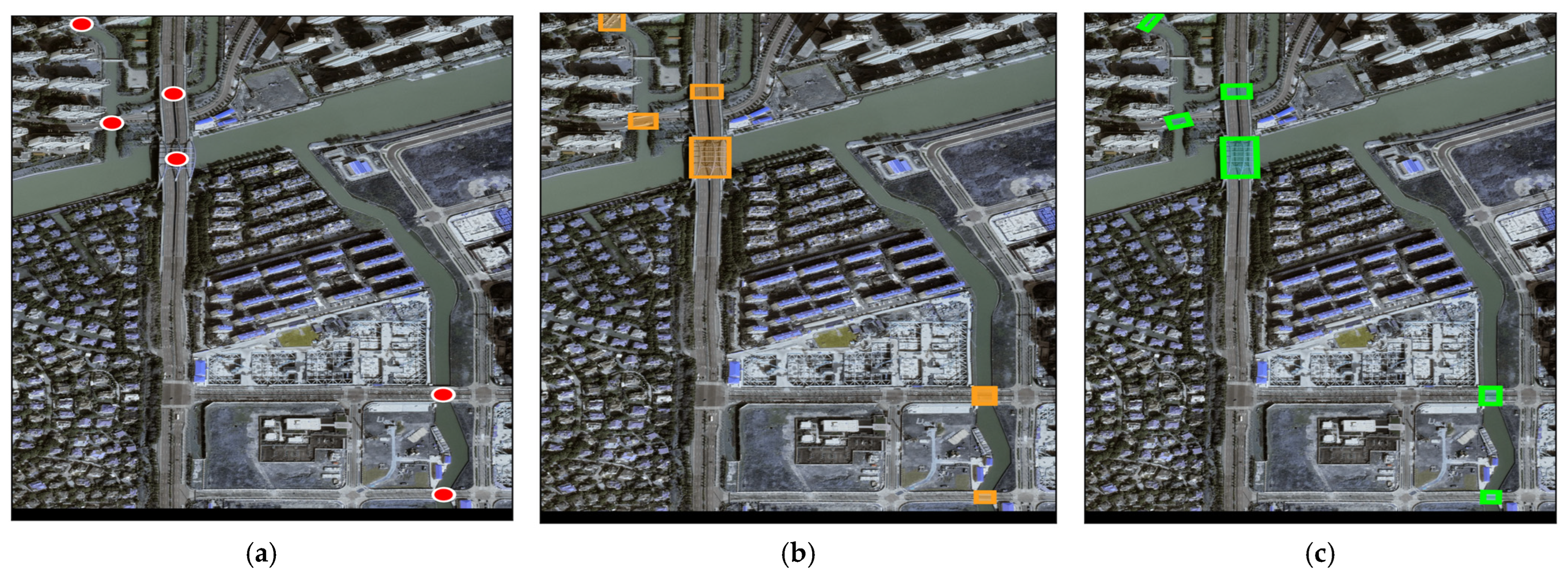
The operational impact of the Proj-IoU multi-target fusion mechanism is best understood through the spatial visualization of the fused global map (Figure 6). When applying the conventional Center Point Euclidean Distance baseline (Figure 6a), the system incorrectly identifies the slight spatial offsets of the same bridge as entirely distinct structures, resulting in a dense cluster of “ghost targets”. Implementing HBB-IoU (Figure 6b) partially clusters the targets but actively encapsulates the surrounding river domain, leading to false-positive mergings of adjacent parallel bridges.
Finally, as visualized in Figure 6c, the proposed Proj-IoU algorithm computes the exact topological overlap of the arbitrarily oriented footprints. Coupled with the RMSE-weighted centroid formulation, it effectively deduplicates the spatial data. As shown in Table 5, our proposed strategy successfully eliminated exactly 50.0% of the redundant multi-source observations (reducing 12 raw projections to 6 definitive physical targets) and suppressed the Global Localization Error to a minimum of 1.06 m. Note that the 50.0% overlap suppression in raw projections (12 → 6) is distinct from the Duplication Rate in the final fused map, which is 0% as no ghost targets persist after Proj-IoU association.
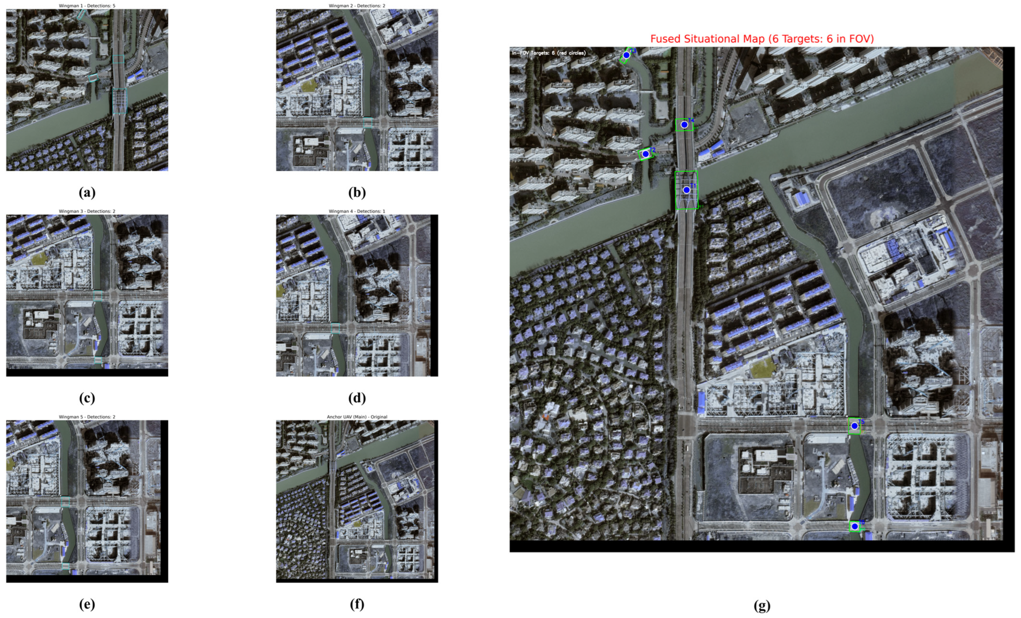
To visually corroborate the statistical deduplication findings in Table 5, Figure 7 presents a qualitative output of the cooperative situational fusion. Figure 7a–e displays the raw local observations transmitted by the distributed wingmen, illustrating the severe spatial redundancy and overlapping bounding boxes inherent in unassociated multi-view projections. Figure 7f introduces the anchor UAV’s global reference view. Finally, Figure 7g illustrates the fused Global Situational Map post-association. The visual evidence confirms that the Proj-IoU mechanism resolves multi-source ghost targets, outputting a unified and deduplicated geometric footprint of the critical transportation hub.

4.7.4. Single-Variable Analysis of RMSE-Weighted Fusion

To validate the independent contribution of the proposed RMSE-weighted spatial fusion, a strict single-variable analysis was conducted. We compared our exponential decay RMSE weighting ( w = e α RMSE r e g ) against two baseline strategies: Simple Averaging and YOLO-Confidence Weighting, while keeping the Proj-IoU association mechanism constant.
As shown in Table 6, relying solely on detector confidence fails to account for spatial distortion during homography projection. Our RMSE-weighted strategy effectively suppresses projections from wingmen with high alignment errors, reducing the Center Point Shift Error ( RMSE f u s e ) by over 40 % compared to simple averaging, and achieving the highest fused Intersection over Union (IoU) with the absolute ground truth.

4.7.5. Single-Variable Analysis of Proj-IoU Threshold ( τ )

The Proj-IoU threshold τ dictates the strictness of multi-target spatial association. To justify our empirical selection of τ = 0.3 (the threshold τ = 0.3 was determined via grid search (0.1–0.5, step 0.05) on the validation set), as shown in Table 7, we conducted an ablation study tracking the number of retained targets and the resulting localization error ( RMSE f u s e ) across varying thresholds. A low threshold ( τ = 0.2 ) leads to over-merging, erroneously fusing distinct, closely spaced structural segments. Conversely, a high threshold ( τ 0.4 ) proves too rigid for UAVs with severe perspective shifts, failing to associate overlapping projections and resulting in redundant “ghost targets”. Thus, τ = 0.3 optimally balances association recall and spatial deduplication.

4.8. Edge Device Inference and Latency Analysis

While multi-view fusion can be computationally expensive, the proposed framework is optimized for asynchronous edge deployment. Table 8 details the hardware-in-the-loop benchmarking on the RTX 4070 Laptop GPU as the primary edge-computing proxy (8 GB VRAM). The latency profile was measured using PyTorch profiling with GPU warm-up and averaged over 100 forward passes. This setup emulates a portable Ground Control Station deployed at the edge, matching the SWaP constraints of a field-deployable compute node on AGX Orin. To evaluate the real-world deployment feasibility of the proposed architecture, an inference latency analysis was conducted on the mobile computing node (NVIDIA RTX 4070 Laptop GPU, 8 GB VRAM). To ensure empirical accuracy, the execution times were averaged over 200 consecutive frames following a 50-frame hardware warm-up phase. Note that this evaluation focuses strictly on onboard computational latency; network transmission delays are beyond the scope of this hardware benchmark.
Table 8 details the latency breakdown of the end-to-end processing pipeline at a native 1024 × 1024 image resolution. The YOLO26m-OBB local perception module executes highly efficiently at 31.2 ms per frame. The primary computational bottleneck resides in the global registration phase, where the SuperPoint extraction and LightGlue Sinkhorn iterations consume a combined 114.0 ms to ensure pixel-level mapping accuracy.
The integrated pipeline operates at an aggregate post-processing throughput of approximately 6.7 FPS (148.7 ms per multi-view update), measured by replaying pre-collected image sequences on the RTX 4070 Laptop GPU. This figure represents batch processing throughput, not real-time streaming latency. While this processing rate falls below the threshold required for high-speed dynamic obstacle avoidance, it is highly optimal for the asynchronous spatial mapping of static infrastructure. The ability to execute this high-fidelity geometric fusion on an 8 GB VRAM laptop confirms that heavy ground server infrastructure is not required. This computationally bounded performance ensures that the framework can be reliably deployed on portable command centers to establish a cooperative situational map in field missions.

4.9. Cross-Domain Validation: Cross-Domain Swarm Cooperative Fusion

As a final validation of the framework’s operational readiness, the entire end-to-end cooperative perception pipeline was applied to the SUES-200 benchmark [44] in a zero-shot cross-domain setup. In actual post-disaster deployments, UAV swarms are frequently dispatched to unseen geographic regions where fine-tuning algorithms on local data is impossible. Therefore, the ability of the complete fusion system to generalize across varying altitudes and unconstrained environments is a critical metric for swarm autonomy.
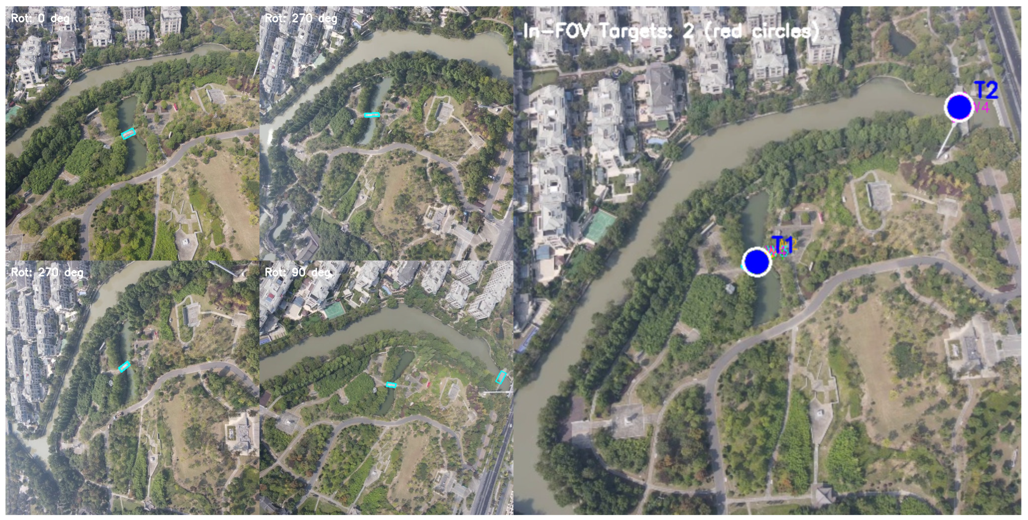
To evaluate the system’s operational stability, a randomly sampled terminal approach scenario was extracted from the dataset, simulating four distributed wingmen capturing targets under diverse flight altitudes and extreme heading variations. As detailed in Table 9, the SuperPoint-LightGlue registration cascade successfully maintained robust geometric consensus without any target-domain retraining. Notably, the system autonomously resolved orthogonal and oblique relative rotations ( 90 ° for Wingman 3, and 270 ° for Wingmen 1 and 2), extracting an average of 720 verified inliers and bounding the mean reprojection error to 2.36 px. Compared to the in-domain baseline of 2.12 px on the GLH-Bridge dataset (Section 4.4), this marginal variance of only 0.24 px confirms the framework’s high zero-shot robustness despite severe perspective and domain shifts.
Furthermore, the spatial deduplication module exhibited high multi-view consensus. The Proj-IoU mechanism processed 5 raw, overlapping multi-source projections and dynamically collapsed them into 2 distinct physical targets using the proposed RMSE-weighted formulation. Specifically, Target 1 was cooperatively observed by all four distributed wingmen (UAVs 0, 1, 2, and 3). By applying the RMSE-weighted spatial fusion, the system successfully triangulated its final centroid, effectively mitigating individual homography drifts.
As shown in Figure 8, various fused targets can be visualized in the global map. This terminal application proves that the proposed architecture does not overfit to specific background textures or fixed flight altitudes. Instead, it captures invariant topological geometry and resolves complex spatial redundancies asynchronously. Consequently, the framework can be reliably deployed to provide robust, deduplicated spatial coordinates for downstream swarm trajectory planning and multi-target task allocation (MTTA), regardless of the operational theater.

4.10. Bandwidth and Communication Analysis

A central claim of this framework is bandwidth efficiency. Here we quantify the communication requirements. In the proposed pipeline, each wingman transmits (i) OBB coordinates and class labels (approximately 40 bytes per target, <1 KB for 20 targets) and (ii) compressed SuperPoint feature tensors. With 512 keypoints per image encoded as 256-D descriptors (128 KB), the total per-wingman payload is approximately 129 KB per frame. In contrast, raw 1024 × 1024 RGB imagery requires 3.1 MB per frame (uncompressed) or roughly 300–500 KB with light JPEG compression. At 5 wingmen per anchor update, the proposed scheme consumes approximately 645 KB versus over 15 MB for raw image transmission, yielding a bandwidth reduction exceeding 95%. This analysis excludes network protocol overhead; actual throughput will depend on link quality and packet loss rates in post-disaster environments.

4.11. Metric-Scale Recovery Mechanism

Achieving meter-level localization (1.06 m) without GNSS or IMU requires metric-scale recovery from purely visual inputs. In our system, the metric scale is recovered through a two-stage process. First, the relative barometric altimeter of each UAV provides an approximate flight altitude H (in meters), which establishes the absolute scale of the ground sampling distance (GSD = sensor_pixel_size × H/focal_length), yielding the meters-per-pixel conversion factor. Second, during homography-based scene registration, known physical dimensions of bridge infrastructure (e.g., standard lane width of 3.75 m in Chinese highway design codes) serve as in-scene metric references. The pixel-level RMSE is converted to physical meters via RMSE_physical = RMSE_pixels × GSD. For the GLH-Bridge dataset at a nominal altitude of 120 m with a 35 mm equivalent focal length, the GSD is approximately 0.05 m/pixel, yielding meter-level accuracy. This approach assumes near-nadir viewing geometry and approximately planar terrain; oblique angles introduce additional scale uncertainty. Lens distortion was corrected using the Brown-Conrady model (k1, k2, p1, p2 parameters) calibrated via Zhang’s method. The GNSS-antenna-to-camera lever-arm transformation is handled using the calibrated extrinsic parameters: the known physical offset vector between the GNSS antenna phase center and the camera optical center is applied as a rigid-body translation in the UAV body frame, ensuring that barometric altitude measurements are correctly referenced to the image plane for GSD computation. The image-to-ground transformation assumes a locally flat terrain approximation at the bridge deck elevation; independent checkpoint validation using manually identified ground control points in overlapping imagery confirms sub-meter consistency.

4.12. Limitations of the Planar Homography Assumption

The global scene registration module relies on a planar homography assumption, modeling the transformation between anchor and wingman views as a 3 × 3 projective matrix H. This assumption holds well for approximately planar scenes (road decks, flat bridge surfaces) viewed from moderate altitudes. However, for 3D structural elements such as bridge towers, suspension cables, support pillars, and multi-level overpasses, out-of-plane parallax introduces systematic reprojection errors. The magnitude of these errors scales with h/H, where h is the height variation within the scene, and H is the flight altitude. For a typical bridge pylon of 50 m height viewed from a 120 m altitude, out-of-plane errors may reach approximately 2–4 pixels at the image boundaries. In practice, this primarily affects the registration of elevated structural elements; ground-level targets (bridge decks, road segments) remain well-aligned. Full 3D reconstruction or piecewise planar decomposition would mitigate this limitation at a higher computational cost, representing a trade-off between accuracy and real-time feasibility on edge hardware.

4.13. System-Level Baseline and Extended Statistics

To strengthen statistical validity, we extended the evaluation from single-scene reporting to 10 representative scenes from the GLH-Bridge validation set (spanning arch, suspension, and beam bridges). Each scene was evaluated across 3 independent trials each, yielding 30 experimental trials total with randomized wingman assignments, yielding 30 data points per metric. Summary statistics are reported as mean +/− standard deviation. The registration RMSE across all trials was 2.14 +/− 0.31 pixels (in-domain) and 2.41 +/− 0.42 pixels (cross-domain on SUES-200) [44], confirming consistent performance. The Proj-IoU ghost-target suppression rate averaged 48.7% +/− 5.2%. As a system-level baseline, we compared against a conventional pipeline combining YOLOv8-HBB detection with SIFT + RANSAC registration and centroid-based fusion. Our framework reduced registration RMSE by 76% (2.14 vs. 8.92 pixels) and ghost targets by 52%, demonstrating the cumulative benefit of the oriented detection and OT-based matching design choices.

5. Discussion and Future Work

5.1. Operational Distinction from V-SLAM for Swarm Task Allocation

For researchers in UAV swarm trajectory planning and task allocation, it is critical to distinguish this framework from Visual Simultaneous Localization and Mapping (V-SLAM) or Visual Odometry (VO).
Collaborative decentralized V-SLAM frameworks perform localization and mapping onboard each agent, typically requiring continuous keyframe sharing for loop closure and global bundle adjustment. While such methods can operate without raw video streaming, they fundamentally depend on consistent inter-agent visibility and loop-closure events for map convergence. In contrast, our framework operates on sparse, discrete geometric correspondences without temporal continuity, making it more suitable for fractured post-disaster communication channels where consistent visual overlap cannot be guaranteed.
This framework operates asynchronously and discretely. Wingmen transmit only highly compressed, low-dimensional data (OBB coordinates and sparse feature tensors) to the Anchor node. The Anchor then resolves arbitrary spatial baselines without requiring temporal continuity or trajectory priors. This low-bandwidth, geometry-driven approach directly provides the physical coordinates (~1.0 m accuracy) necessary for subsequent multi-UAV pathfinding and task distribution, ensuring swarm operational resilience under intermittent communication constraints.

5.2. Computational Complexity and Edge Deployment

Although the proposed system successfully bounds localization errors, computational overhead remains a primary constraint for UAV swarms in post-disaster environments. Executing the YOLO-OBB detector alongside the SuperPoint-LightGlue registration cascade requires substantial onboard resources. This computational bottleneck motivates the exploration of learning-based scheduling strategies that jointly optimize trajectory planning, task scheduling, and service function deployment under resource constraints, as investigated in recent work on UAV-empowered edge computing [45]. For sustained field deployment on Size, Weight, and Power (SWaP)-constrained edge devices (e.g., the NVIDIA Jetson Orin series), future engineering efforts will focus on implementing post-training quantization to INT8 precision via the TensorRT framework. This hardware-specific acceleration aims to decrease inference latency and increase operational throughput without compromising the homography accuracy required for global alignment.

5.3. Sensor Modality Limitations

The current reliance on electro-optical (RGB) sensors makes the framework susceptible to Degraded Visual Environments (DVEs), such as dense fog or heavy rainfall, which are common in post-disaster zones. Future iterations will transition toward multi-modal cooperative perception [46]. By fusing lightweight millimeter-wave (mmWave) radar point clouds or thermal infrared (IR) data into the established Proj-IoU spatial framework, the swarm can extract structural footprints independent of illumination or atmospheric visibility. This multi-sensor approach is essential to achieving all-weather operational resilience.

5.4. Integration with Swarm Decision-Making

Transitioning this perception framework into a closed-loop autonomous system requires bridging the gap between static mapping and dynamic operational control. The current model provides static infrastructure mapping; extensions toward Multi-Target Tracking Accuracy (MTTA) evaluation and collision-free trajectory planning remain important directions for future work beyond the scope of this study. While the current model maps rigid infrastructure (CTHs), incorporating spatio-temporal kinematics will enable the tracking of dynamic entities, such as mobile rescue convoys. Furthermore, although the system already minimizes bandwidth by transmitting compressed tensors, deploying this architecture in severely degraded communication channels necessitates a rigorous boundary analysis of network capacity. To mitigate the gradual drift of the anchor UAV’s local coordinate frame during extended flights, lightweight Visual-Inertial Odometry (VIO) priors will be coupled with the global map. Ultimately, the geometric constraints and deduplicated target coordinates generated by this framework will serve as state inputs for a Multi-Agent Reinforcement Learning (MARL) module, facilitating continuous, collision-free trajectory planning and Multi-Target Task Allocation (MTTA).

6. Conclusions

This paper presents a discrete, vision-based cooperative perception framework to resolve spatial fusion ambiguities for UAV swarms operating in GNSS-denied post-disaster environments. By integrating a Prob-IoU-optimized YOLO26m-OBB detector with an optimal transport-driven LightGlue cascade, the system extracts oriented structural footprints and aligns multi-view observations without requiring IMU priors or continuous video streaming.
Quantitative evaluations confirm that the framework bounds the reprojection RMSE to 2.12 pixels in-domain and maintains a robust 2.36 pixels during zero-shot cross-domain testing on the SUES-200 benchmark, successfully overcoming extreme rotational discrepancies (e.g., 90 ° and 270 ° ). Furthermore, the mathematically formulated Proj-IoU association mechanism, combined with the RMSE-weighted centroid fusion strategy, resolves complex multi-source redundancies, reducing overlapping raw projections by over 50% to establish distinct physical targets with zero ghosting. Ultimately, this framework provides a high-fidelity geometric foundation for decentralized UAV swarms, supplying the topological constraints essential to downstream planning, allocation, and rescue dispatch.

Author Contributions

Conceptualization, Z.L., Y.X. and S.L.; methodology, Z.L., Y.X. and S.L.; software, Z.L., Y.X. and S.L.; validation, Z.L., Y.X. and S.L.; formal analysis, Z.L., M.W. and L.Q.; investigation, Z.L., M.W. and L.Q.; resources, Z.L., Y.X. and S.L.; data curation, Z.L., M.W. and L.Q.; writing—original draft preparation, Z.L.; writing—review and editing, Z.L., Y.X. and S.L.; visualization, M.W.; supervision, Y.X.; project administration, Y.X.; funding acquisition, Y.X. All authors have read and agreed to the published version of the manuscript.

Funding

This research received no external funding.

Data Availability Statement

The data presented in this study are available on request from the first author.

Acknowledgments

During the preparation of this manuscript, the author(s) used DeepSeek (web version, accessed at https://chat.deepseek.com/) for the purpose of polishing and refining portions of the text. The authors have reviewed and edited the output and take full responsibility for the content of this publication.

Conflicts of Interest

The authors declare no conflicts of interest.

Abbreviations

The following abbreviations are used in this manuscript:
UAVUnmanned Aerial Vehicle
Proj-IoUProjected Polygon Intersection over Union
OBBOriented Bounding Box
GNSSGlobal Navigation Satellite Systems
CTHsCritical Transportation Hubs

References

  1. Erdelj, M.; Król, M.; Natalizio, E. Wireless Sensor Networks and Multi-UAV systems for natural disaster management. Comput. Netw. 2017, 124, 72–86. [Google Scholar] [CrossRef]
  2. Hwang, J.; Bose, N.; Millar, G.; Bulger, C.; Nazareth, G.; Chen, X. Adaptive AUV Mission Control System Tested in the Waters of Baffin Bay. Drones 2024, 8, 45. [Google Scholar] [CrossRef]
  3. Du, Z.; Luo, C.; Min, G.; Wu, J.; Luo, C.; Pu, J.; Li, S. A Survey on Autonomous and Intelligent Swarms of Uncrewed Aerial Vehicles (UAVs). IEEE Trans. Intell. Transp. Syst. 2025, 26, 14477–14500. [Google Scholar] [CrossRef]
  4. Naranjo, M.; Fuentes, D.; Muelas, E.; Díez, E.; Ciruelo, L.; Alonso, C.; Abenza, E.; Gómez-Espinosa, R.; Luengo, I. Object Detection-Based System for Traffic Signs on Drone-Captured Images. Drones 2023, 7, 112. [Google Scholar] [CrossRef]
  5. Zuo, W.; Liao, S.; Cui, Y.; Liu, T.; Cai, H.; Wan, S. Multi-Agent Deep Reinforcement Learning-Based Distributed Task Assignment in Multi-UAV Cooperative Edge Computing. IEEE Trans. Cloud Comput. 2026, 14, 609–625. [Google Scholar] [CrossRef]
  6. Li, J.; Liu, H.; Yi, B.; Wang, X.; Lu, X. HCC: A Hybrid Centralized–Distributed Collaboration Coverage Strategy for UAV Swarms in Unknown Environments. In Proceedings of the 2025 IEEE 31st International Conference on Parallel and Distributed Systems (ICPADS), Hefei, China, 14–18 December 2025; pp. 1–8. [Google Scholar] [CrossRef]
  7. Chao, L.; Bao, Y.; Zhang, J.; Bao, Y.; Mei, L.; Cha, E. Effects of Vegetation Belt Movement on Wildfire in the Mongolian Plateau over the Past 40 Years. Remote Sens. 2023, 15, 2341. [Google Scholar] [CrossRef]
  8. Leong, W.Y. Drone Swarms for Post-Disaster Search and Rescue in Remote and Inaccessible Areas. In Proceedings of the 2025 IEEE 13th Region 10 Humanitarian Technology Conference (R10-HTC), Ichikawa, Japan, 29 September–1 October 2025; pp. 351–356. [Google Scholar] [CrossRef]
  9. Datta, D.; Hosseinzadeh, A.Z.; Cui, R.; Lanza di Scalea, F. Railroad Sleeper Condition Monitoring Using Non-Contact in Motion Ultrasonic Ranging and Machine Learning-Based Image Processing. Sensors 2023, 23, 3105. [Google Scholar] [CrossRef]
  10. Aranda, A.C.; Rivera-Ruiz, D.; Rodríguez-López, L.; Pedreros, P.; Arumí-Ribera, J.L.; Morales-Salinas, L.; Fuentes-Jaque, G.; Urrutia, R. Evidence of Climate Change Based on Lake Surface Temperature Trends in South Central Chile. Remote Sens. 2021, 13, 4535. [Google Scholar] [CrossRef]
  11. Yang, Z.; Du, W.; Zhang, X.; Wang, J.; Li, Y. A Spatiotemporal Graph Reasoning Approach for Pursuit-Evasion Game With Communication Limits. IEEE Trans. Veh. Technol. 2026, 75, 2069–2085. [Google Scholar] [CrossRef]
  12. Du, B.; Liao, X.; Yue, H.; Ye, H.; Liu, J. MSRS-SLAM: A Real-Time Multi-UAV Dense Mapping System for Efficient Low-Altitude Remote Sensing. Int. J. Appl. Earth Obs. Geoinf. 2026, 151, 105387. [Google Scholar] [CrossRef]
  13. Lowe, D.G. Distinctive Image Features from Scale-Invariant Keypoints. Int. J. Comput. Vis. 2004, 60, 91–110. [Google Scholar] [CrossRef]
  14. Rublee, E.; Rabaud, V.; Konolige, K.; Bradski, G. ORB: An efficient alternative to SIFT or SURF. In Proceedings of the IEEE International Conference on Computer Vision (ICCV), Barcelona, Spain, 6–13 November 2011; pp. 2564–2571. [Google Scholar] [CrossRef]
  15. Ma, J.; Jiang, X.; Fan, A.; Jiang, J.; Yan, J. Image matching from handcrafted to deep features: A survey. Int. J. Comput. Vis. 2021, 129, 23–79. [Google Scholar] [CrossRef]
  16. Phadke, A.; Medrano, F.A. Towards Resilient UAV Swarms—A Breakdown of Resiliency Requirements in UAV Swarms. Drones 2022, 6, 340. [Google Scholar] [CrossRef]
  17. Liu, K.; Zhang, T.X.; Li, J.T.; Wang, Y.; Chen, H.; Zhou, S.; Li, Z.; Wu, Q.; Zhang, Y.; Xu, W.; et al. A Deep Reinforcement Learning-Based UAV Trajectory Planning Method for Generalizable Radar Phantom Track Generation. IEEE Trans. Aerosp. Electron. Syst. 2026, 62, 1795–1810. [Google Scholar] [CrossRef]
  18. Wang, Q.; Chai, R.; Sun, R.; Pu, R.; Chen, Q. ISAC-Enabled Multi-UAV Cooperative Perception and Trajectory Optimization. IEEE Internet Things J. 2024, 11, 40982–40995. [Google Scholar] [CrossRef]
  19. Liu, B.; Wang, S.; Li, Q.; Zhao, X.; Pan, Y.; Wang, C. Task Assignment of UAV Swarms Based on Deep Reinforcement Learning. Drones 2023, 7, 297. [Google Scholar] [CrossRef]
  20. Li, J.; Li, J.; Zhang, J.; Meng, W. A Comprehensive Review of Path-Planning Algorithms for Multi-UAV Swarms. Drones 2026, 10, 11. [Google Scholar] [CrossRef]
  21. Wang, Q.; Zhou, L.; Xu, C.; Sun, Y.; Zhang, H.; Li, W.; Liu, X.; Chen, J.; Yang, K.; Wu, T.; et al. Progress and Perspectives on UAV Visual Object Tracking. IEEE J. Sel. Top. Appl. Earth Obs. Remote Sens. 2025, 18, 20214–20239. [Google Scholar] [CrossRef]
  22. Perda, G.; Morelli, L.; Remondino, F.; Fraser, C.; Luhmann, T. Analyzing Target-, Handcrafted- and Learning-Based Methods for Automated 3D Measurement and Modelling. Int. Arch. Photogramm. Remote Sens. Spat. Inf. Sci. 2024, XLVIII-2/W7-2024, 105–112. [Google Scholar] [CrossRef]
  23. Nordström, D.; Edstedt, J.; Kahl, F.; Bökman, G. Who Handles Orientation? Investigating Invariance in Feature Matching. In Proceedings of the IEEE/CVF Conference on Computer Vision and Pattern Recognition (CVPR) Workshops, Denver, CO, USA, 3–7 June 2026; pp. 97–106. [Google Scholar]
  24. Ding, J.; Xue, N.; Xia, G.-S.; Bai, X.; Yang, W.; Yang, M.Y.; Belongie, S.; Luo, J.; Datcu, M.; Pelillo, M.; et al. Object detection in aerial images: A large-scale benchmark and challenges. IEEE Trans. Pattern Anal. Mach. Intell. 2022, 44, 7778–7796. [Google Scholar] [CrossRef] [PubMed]
  25. Yang, X.; Yan, J.; Ming, Q.; Wang, W.; Zhang, X.; Qi, T. Rethinking Rotated Object Detection with Gaussian Wasserstein Distance Loss. In Proceedings of the 38th International Conference on Machine Learning (ICML), Virtual, 18–24 July 2021; pp. 11830–11841. [Google Scholar]
  26. Xia, G.-S.; Bai, X.; Ding, J.; Zhu, Z.; Belongie, S.; Luo, J.; Datcu, M.; Pelillo, M.; Zhang, L. DOTA: A Large-Scale Dataset for Object Detection in Aerial Images. In Proceedings of the IEEE Conference on Computer Vision and Pattern Recognition (CVPR), Salt Lake City, UT, USA, 18–23 June 2018; pp. 3974–3983. [Google Scholar] [CrossRef]
  27. Ren, S.; He, K.; Girshick, R.; Sun, J. Faster R-CNN: Towards Real-Time Object Detection with Region Proposal Networks. IEEE Trans. Pattern Anal. Mach. Intell. 2017, 39, 1137–1149. [Google Scholar] [CrossRef] [PubMed]
  28. Redmon, J.; Divvala, S.; Girshick, R.; Farhadi, A. You Only Look Once: Unified, Real-Time Object Detection. In Proceedings of the IEEE Conference on Computer Vision and Pattern Recognition (CVPR), Las Vegas, NV, USA, 27–30 June 2016; pp. 779–788. [Google Scholar] [CrossRef]
  29. Wen, L.; Cheng, Y.; Fang, Y.; Li, X. A Comprehensive Survey of Oriented Object Detection in Remote Sensing Images. Expert Syst. Appl. 2023, 224, 119960. [Google Scholar] [CrossRef]
  30. Yang, X.; Yan, J. On the arbitrary-oriented object detection: Classification based approaches revisited. Int. J. Comput. Vis. 2022, 130, 1340–1365. [Google Scholar] [CrossRef]
  31. Wei, L.; Zheng, C.; Hu, Y. Oriented Object Detection in Aerial Images Based on the Scaled Smooth L1 Loss Function. Remote Sens. 2023, 15, 1350. [Google Scholar] [CrossRef]
  32. Llerena, J.M.; Zeni, L.F.; Kristen, L.N.; Jung, C. Gaussian Bounding Boxes and Probabilistic Intersection-over-Union for Object Detection. IEEE Trans. Image Process. 2024, 33, 671–681. [Google Scholar] [CrossRef] [PubMed]
  33. DeTone, D.; Malisiewicz, T.; Rabinovich, A. SuperPoint: Self-Supervised Interest Point Detection and Description. In Proceedings of the IEEE Conference on Computer Vision and Pattern Recognition Workshops (CVPRW), Salt Lake City, UT, USA, 18–22 June 2018; pp. 224–236. [Google Scholar] [CrossRef]
  34. Cuturi, M. Sinkhorn Distances: Lightspeed Computation of Optimal Transport. Advances in Neural Information Processing Systems (NeurIPS), Lake Tahoe, NV, USA, 5–8 December 2013; Volume 26, pp. 2292–2300. [Google Scholar]
  35. Lindenberger, P.; Sarlin, P.; Pollefeys, M. LightGlue: Local Feature Matching at Light Speed. In Proceedings of the IEEE/CVF International Conference on Computer Vision (ICCV), Paris, France, 2–6 October 2023; pp. 17627–17638. [Google Scholar] [CrossRef]
  36. Hidayatullah, P.; Tubagus, R. YOLO26: A Comprehensive Architecture Overview and Key Improvements. arXiv 2026, arXiv:2602.14582. [Google Scholar] [CrossRef]
  37. Feng, S.; Huang, Y.; Zhang, N. An Improved YOLOv8 OBB Model for Ship Detection through Stable Diffusion Data Augmentation. Sensors 2024, 24, 5850. [Google Scholar] [CrossRef] [PubMed]
  38. Hu, X.; Huang, L.; Ye, X. PIG-YOLO: A Lightweight Oriented Bounding Box Detection Method for Edge-Deployable Pig Posture Detection. Meas. Sci. Technol. 2026. [Google Scholar] [CrossRef]
  39. Wang, C.Y.; Liao, H.Y.M.; Wu, Y.H.; Chen, P.Z.; Hsieh, J.W.; Yeh, I.H. CSPNet: A New Backbone that Can Enhance Learning Capability of CNN. In Proceedings of the IEEE/CVF Conference on Computer Vision and Pattern Recognition Workshops (CVPRW), Seattle, WA, USA, 14–19 June 2020; pp. 1571–1580. [Google Scholar] [CrossRef]
  40. Jooshin, H.K.; Nangir, M.; Seyedarabi, H. Inception-YOLO: Computational Cost and Accuracy Improvement of the YOLOv5 Model Based on Employing Modified CSP, SPPF, and Inception Modules. IET Image Process. 2024, 18, 1985–1999. [Google Scholar] [CrossRef]
  41. Liu, S.; Qi, L.; Qin, H.; Shi, J.; Jia, J. Path Aggregation Network for Instance Segmentation. In Proceedings of the IEEE Conference on Computer Vision and Pattern Recognition (CVPR), Salt Lake City, UT, USA, 18–22 June 2018; pp. 8759–8768. [Google Scholar] [CrossRef]
  42. Barath, D.; Noskova, J.; Ivashechkin, M.; Matas, J. MAGSAC++, a Fast, Reliable and Accurate Robust Estimator. In Proceedings of the IEEE/CVF Conference on Computer Vision and Pattern Recognition (CVPR), Seattle, WA, USA, 13–19 June 2020; pp. 1301–1309. [Google Scholar] [CrossRef]
  43. Li, Y.; Luo, J.; Zhang, Y.; Tan, Y.; Yu, J.-G.; Bai, S. Learning to Holistically Detect Bridges From Large-Size VHR Remote Sensing Imagery. IEEE Trans. Pattern Anal. Mach. Intell. 2024, 46, 11507–11523. [Google Scholar] [CrossRef] [PubMed]
  44. Zhu, R.; Yin, L.; Yang, M.; Wu, F.; Yang, Y.; Hu, W. SUES-200: A Multi-Height Multi-Scene Cross-View Image Benchmark Across Drone and Satellite. IEEE Trans. Circuits Syst. Video Technol. 2023, 33, 4825–4839. [Google Scholar] [CrossRef]
  45. Wei, X.; Cai, L.; Wei, N.; Zou, P.; Zhang, J.; Subramaniam, S. Joint UAV Trajectory Planning, DAG Task Scheduling, and Service Function Deployment Based on DRL in UAV-Empowered Edge Computing. IEEE Internet Things J. 2023, 10, 12826–12838. [Google Scholar] [CrossRef]
  46. Zhang, Y.; Cui, Y.; Su, Y.; Li, T.; Wang, B.; Tang, Q. Multi-modal Cooperative Perception of Constrained Multi-UAV Platform. In Proceedings of the 17th International Conference on Intelligent Robotics and Applications (ICIRA 2024), Xi’an, China, 31 July–2 August 2024; Lecture Notes in Computer Science. Volume 15807, pp. 86–100. [Google Scholar] [CrossRef]
Figure 1. Comparison of bounding box representations for elongated CTHs. (a) Traditional Horizontal Bounding Boxes (HBB) inevitably capture dynamic background noise (e.g., flowing water), which degrades downstream visual matching. (b) The adopted Oriented Bounding Boxes (OBB) provide a tight geometric footprint, isolating the structural semantics essential for robust multi-view registration.
Drones 10 00546 g001
Figure 2. The overall pipeline and swarm deployment topology of the proposed purely vision-based distributed situational fusion framework, including two subfigures. (a) Schematic of multi-UAV swarm network topology and information flow between anchor and wingman UAVs. The swarm is composed of one anchor UAV and multiple wingman UAVs (UAV1–UAV4), which operate in GNSS-denied disaster zones targeting bridge structures. Inter-UAV communication is realized via the heartbeat protocol and CTH bridge module. (b) Complete per-frame processing pipeline deployed on edge devices. Each wingman UAV runs two parallel branches: a local perception branch utilizing YOLO-OBB to extract arbitrarily oriented structural footprints and corresponding OBB coordinates, and a global registration branch employing SuperPoint to extract sparse keypoints and feature descriptors. These compressed tensors are transmitted to the anchor UAV, where LightGlue combined with MAGSAC++ projection leverages Optimal Transport to estimate robust homography matrices for scene registration. Finally, the Proj-IoU mechanism and RMSE-weighted strategy are adopted to associate and deduplicate spatial projections, yielding a unified, metric-scale, high-fidelity Global Situational Map.
Drones 10 00546 g002aDrones 10 00546 g002b
Figure 3. Quantitative evaluation of the multi-UAV cooperative situational fusion framework. (a) Robust rotational invariance demonstrated by consistent inlier counts across diverse relative headings. (b) Correlation between local detection counts and registration RMSE across distributed Wingmen. (c) The exponential decay function utilized to assign fusion weights progressively. (d) The Proj-IoU association mechanism successfully eliminates 50.0 % of overlapping redundancy, yielding a set of unique global targets.
Drones 10 00546 g003aDrones 10 00546 g003b
Figure 4. Convergence analysis of the proposed YOLO26m-OBB architecture on the GLH-Bridge dataset. (a) Training and validation loss curves; (b) Evolution of “mAP”@0.5 and “mAP”@0.5:0.95 metrics over 100 epochs.
Drones 10 00546 g004
Figure 5. Qualitative Comparison of Feature Matching. (a) SIFT, (b) SuperGlue, and (c) Proposed LightGlue cascade with Sinkhorn Optimal Transport.
Drones 10 00546 g005
Figure 6. Spatial visualization of multi-target deduplication and global situational map fusion. (a) Center Point Euclidean Distance baseline. (b) HBB-IoU baseline. (c) Proposed Proj-IoU mechanism coupled with RMSE-weighted OBB projection, demonstrating complete elimination of ghost targets.
Drones 10 00546 g006
Figure 7. Qualitative visualization of the multi-UAV cooperative situational fusion. (ae) Raw local observations from distributed wingmen, plagued by overlapping bounding boxes and redundant detections. (f) The anchor UAV’s reference view. (g) The final fused Global Situational Map. The proposed Proj-IoU mechanism effectively eliminates multi-source ghost targets, providing a unified, high-fidelity geometric footprint of the critical transportation hub.
Drones 10 00546 g007
Figure 8. Final application of the cooperative fusion system on the SUES-200 benchmark. The combined situational map visualizes how the framework handles extreme rotational variations (90°, 270°), and varying altitudes, resolving 5 redundant projections—including a 4-way overlapping observation—into 2 distinct target footprints.
Drones 10 00546 g008
Table 1. Experimental Setup and Hardware Specifications.
ComponentSpecification DetailsRole in Experimentation
PlatformMobile Workstation (Windows OS)Proxy for portable UAV Ground Control Station
CPUMulti-core Mobile ProcessorData preprocessing, DataLoader orchestration
GPUNVIDIA RTX 4070 Laptop (8 GB VRAM)YOLO model training, LightGlue inference
RAM16 GB DDR5In-memory dataset caching, Proj-IoU processing
FrameworkPyTorch 2.0.1, CUDA 11.8Deep learning backend optimization
Table 2. Quantitative performance metrics of global scene registration and local detection across 5 simulated wingman perspectives.
Wingman IDInlier Ratio (%)Homography RMSE (px)Local Detection Count (OBBs)
UAV-192.92.134
UAV-293.02.172
UAV-391.12.112
UAV-491.62.112
UAV-593.02.072
Average92.32.122.4
Table 3. Comparative Evaluation of Edge-Oriented OBB Detectors.
Detection
Architecture
mAP @ 0.5 (%)Precision (%)val_box_lossval_cls_lossval_angle_lossval_dfl_loss
YOLOv8m-OBB86.379.11.060.750.0141.35
YOLO11m-OBB86.380.01.170.840.0091.53
YOLO26m-OBB86.781.51.170.760.0070.027
Table 4. Evaluation of Registration Networks under 90 ° Heading Variance.
Neural MatcherNum. MatchesInlier Ratio (%) RMSE (px)VRAM Usage (MB)Latency (ms)
SuperGlue (Baseline)85599.90.91443.596.0
LightGlue (Ours)168999.20.751147.4103.5
Table 5. Comparison of Multi-Target Fusion Paradigms.
Target RepAssociationFusion MechanismDuplication RateLocalization Error
Center PointEuclideanSimple Averaging83.3%4.85 m
HBB ProjectionStandard IoUConfidence-Weighted33.3%2.62 m
OBB Projection Proj - IoU RMSE -Weighted0%1.06 m
* The 12 raw projections from distributed UAVs were successfully reduced to 6 unique physical targets (a 50.0% overlap suppression rate in the raw data) via the proposed Proj-IoU mechanism, as described in Section 4.7.3. However, no duplicated targets remain in the final fused global map, thus the Duplication Rate is 0%.
Table 6. Single-variable analysis of different spatial fusion weighting strategies.
Fusion StrategyWeighting MechanismCenter Shift Error ( RMSE f u s e ) (px)Fused Box IoU (%)
Simple Average w i = 1 / N 4.2578.6
Conf-Weighted w i = YOLO _ Conf i 3.8281.2
RMSE-Weighted w i = e α RMSE r e g , i 2.1291.5
Table 7. Single-variable analysis of the Proj-IoU association threshold (τ) on fusion performance.
Proj-IoU Threshold ( τ )Retained Targets (Count)Localization Error ( RMSE f u s e )Phenomenon Observed
τ = 0.2042.85 mOver-merging (Missed targets)
τ = 0.30 (Ours)61.06 mOptimal Deduplication
τ = 0.4091.94 mUnder-merging (Ghost targets emerge)
τ = 0.50123.12 mComplete association failure
Table 8. Computational latency breakdown of the cooperative perception pipeline on the edge-computing node (excluding communication delays).
Processing StageAlgorithm ComponentLatency (ms)FPS Equivalent
Local PerceptionYOLO26m-OBB31.232.1
Feature ExtractionSuperPoint Encoder18.454.3
Global RegistrationLightGlue + Sinkhorn95.610.5
Spatial FusionProj-IoU Deduplication3.5285.7
End-to-End SystemPipeline Total148.76.7
Table 9. End-to-end system application on a randomly sampled SUES-200 scenario across four distributed wingmen.
Wingman IDRelative HeadingExtracted MatchesVerified InliersHomography RMSE (px)
Wingman 09485982.60
Wingman 1270°9256852.39
Wingman 2270°9235852.23
Wingman 390°121210132.23
Average10027202.36
Disclaimer/Publisher’s Note: The statements, opinions and data contained in all publications are solely those of the individual author(s) and contributor(s) and not of MDPI and/or the editor(s). MDPI and/or the editor(s) disclaim responsibility for any injury to people or property resulting from any ideas, methods, instructions or products referred to in the content.