Article

Aesthetic-Aware Trajectory Planning for Multi-ROI UAV Aerial Cinematography

School of Remote Sensing and Information Engineering, Wuhan University, Wuhan 430079, China
*
Author to whom correspondence should be addressed.
Drones 2026, 10(5), 380; https://doi.org/10.3390/drones10050380
Submission received: 14 April 2026 / Revised: 13 May 2026 / Accepted: 14 May 2026 / Published: 16 May 2026

Highlights

What are the main findings?
  • We propose an aesthetic-aware UAV trajectory planning framework for multi-ROI aerial cinematography that integrates viewpoint selection, trajectory generation, and global route optimization.
  • The proposed method effectively balances flight feasibility, planning efficiency, and visual composition quality through a hierarchical planning strategy.
What are the implications of the main findings?
  • The framework enables more autonomous and efficient UAV cinematography workflows, reducing dependence on manual operation and professional piloting skills.
  • The integration of learning-based aesthetic evaluation provides a practical approach for improving visual quality in real-world UAV applications.

Abstract

UAV aerial cinematography has become increasingly important in film production, surveying, and smart-city applications due to its efficiency and creative potential. However, existing UAV filming workflows still rely heavily on manual operation and professional piloting skills, resulting in complex mission design, limited planning autonomy, and inconsistent visual quality. To address these challenges, this paper proposes a unified aesthetics-aware trajectory planning framework for multi-region-of-interest (multi-ROI) UAV aerial cinematography that automatically generates safe, efficient, and visually coherent flight paths from user-specified ROIs. The proposed framework consists of three main components. First, for each ROI, candidate viewpoints are sampled using a spiral trajectory, and a learning-based aesthetic evaluation network is applied to select visually optimal viewpoints for local trajectory generation. Second, transition trajectories between ROIs are generated using a Goal-biased Bidirectional Rapidly exploring Random Tree Star (Goal-biased BiRRT*) planner and evaluated through a multi-objective cost function to determine the most suitable transition paths. Third, the global connection of multiple ROIs is formulated as a Set Traveling Salesman Problem (STSP) to obtain an efficient visiting sequence. By integrating learning-based aesthetic evaluation with hierarchical trajectory planning and coordinated multi-ROI route organization, the proposed framework jointly considers flight feasibility, planning efficiency, visual composition quality, and trajectory continuity within a unified planning pipeline. Experimental results demonstrate that the proposed method generates more visually appealing and coherent aerial trajectories than traditional manual or rule-based approaches, while significantly reducing operational complexity. The proposed system provides an effective solution for autonomous UAV aerial cinematography with improved global consistency, aesthetic performance, and practical planning capability in complex environments.

1. Introduction

With the rapid advancement of unmanned aerial vehicle (UAV) technology, UAV-based aerial cinematography and image acquisition have become an important component of intelligent visual perception systems [1]. Such applications require not only safe and efficient flight control but also high-quality camera motion planning to generate continuous and aesthetically appealing aerial videos. In complex outdoor environments, the ability to autonomously generate visually expressive and smooth flight trajectories is crucial for improving the practical value of UAV systems in film production [2,3], surveying and mapping [4,5], and smart-city applications [6,7,8,9]. However, achieving cinematography-level route planning that simultaneously considers flight safety, efficiency, and visual composition remains a challenging problem.
Therefore, developing a unified UAV cinematography planning framework that jointly integrates aesthetic-aware evaluation, intelligent camera pose control, multi-region-of-interest (multi-ROI) trajectory organization, and autonomous route planning is of both theoretical and practical importance.
Existing UAV route planning approaches can generally be categorized into two groups. The first group focuses on navigation and safety, including model predictive control (MPC) [10], reinforcement learning (RL)-based flight control [11], and geometry-based path optimization methods [12]. These methods are effective at generating dynamically feasible and collision-free trajectories in complex environments, thereby providing strong safety guarantees for autonomous UAV operation. However, their optimization objectives are typically limited to motion-related metrics such as path length, smoothness, or control cost, while the influence of camera pose on visual composition and image quality is rarely considered. Consequently, they are not well suited for aerial cinematography tasks that require continuous camera motion and aesthetic consistency.
The second group focuses on vision-oriented tasks such as close-range photogrammetry [13], three-dimensional reconstruction [14], and UAV-based target tracking [15]. These approaches often improve local observation quality by maintaining visual focus on regions of interest (ROIs), achieving promising performance in specific applications. Nevertheless, most of these methods rely on predefined camera parameters or manual adjustments, and their optimization is usually restricted to single objectives or local routes. As a result, they lack systematic modeling of global flight routing, camera motion continuity, coordinated multi-ROI cinematography, and unified aesthetics-aware trajectory organization, making them difficult to extend to complex autonomous aerial cinematography missions.
In addition to academic research, commercial UAV platforms such as DJI Ground Station Pro (DJI, Shenzhen, China) and Airnest provide waypoint-based semi-automatic mission planning. However, users still need to manually configure parameters including waypoint altitude, speed, gimbal pitch, and vehicle yaw, making the workflow time-consuming and highly dependent on operator experience [16]. More importantly, these systems mainly rely on predefined waypoint rules and do not explicitly model cinematic metrics such as composition quality, trajectory continuity, or coordinated visual storytelling, which limits their ability to support highly autonomous and aesthetics-aware aerial cinematography in complex multi-ROI environments.
To address these limitations, this paper proposes a unified aesthetics-aware UAV aerial cinematography framework that integrates learning-based viewpoint evaluation, hierarchical trajectory planning, and coordinated multi-ROI route organization within a unified planning pipeline. Given a user-defined scene and a set of ROIs, the proposed framework automatically generates collision-free and visually coherent flight trajectories in complex three-dimensional environments while improving planning autonomy and maintaining practical computational feasibility. From a system perspective, the framework jointly considers three key aspects within a unified planning pipeline: (i) local trajectory generation and viewpoint optimization within each ROI, (ii) transition path planning between ROIs, and (iii) global organization of multiple ROIs. Through coordinated optimization across these planning layers, the system simultaneously satisfies flight feasibility, planning efficiency, and visual quality requirements. The contribution of this work mainly lies in the unified hierarchical formulation and coordinated integration of aesthetics-aware viewpoint evaluation, local trajectory generation, inter-ROI transition planning, and global route organization for autonomous UAV cinematography, rather than in proposing entirely new low-level optimization algorithms.
The main contributions of this work are summarized as follows:
  • We introduce a unified aesthetics-aware UAV aerial cinematography planning framework that hierarchically coordinates flight trajectory generation, camera pose control, inter-ROI transition planning, and global route organization, enabling simultaneous optimization of motion feasibility and visual appeal under multiple geometric and visual constraints.
  • We develop a learning-based aesthetic evaluation mechanism for aerial viewpoints that quantitatively measures composition quality, providing a computable basis for incorporating visual aesthetics into UAV trajectory planning and decision-making.
  • We propose a hierarchical and coordinated planning strategy from local to global levels, which unifies within-ROI filming optimization, inter-ROI transition planning, and global multi-ROI route organization within a coordinated cinematography pipeline to achieve a balanced trade-off among flight safety, path efficiency, and visual continuity in complex environments.
The remainder of this paper is organized as follows. Section 2 reviews related work on aesthetics-driven camera control and UAV aerial cinematography path planning. Section 3 introduces the proposed multi-ROI UAV cinematography planning method. Section 4 presents the experimental setup and evaluation results. Finally, Section 5 concludes the paper and discusses future research directions.

2. Related Work

2.1. Aesthetics-Based Camera Control

Aesthetics-driven camera control has long been an important topic in automated cinematography and virtual camera systems. Early studies mainly focused on geometric constraints, adjusting camera position, orientation, and field of view to satisfy predefined composition requirements [17,18,19]. These methods primarily addressed target visibility, spatial layout, and viewpoint feasibility, but lacked explicit modeling of higher-level visual aesthetic characteristics and cinematographic semantics.
Subsequent research attempted to formalize cinematographic language and artistic composition principles into computable models. Datta et al. [20] and Mai et al. [21] explored computational representations of photographic aesthetics and composition rules. Arijon [22] and Bowen [23] summarized empirical cinematographic composition guidelines, while He et al. [24] incorporated visual composition features into automated framing algorithms. Gebhardt et al. [25] quantified traditional photographic principles such as the rule of thirds, target visibility, and visual balance and transformed them into mathematical cost functions to guide autonomous UAV cinematography. V’azquez et al. [26] introduced the concept of viewpoint entropy to measure the information conveyed by viewpoints in a 3D scene and used it to compute high-quality viewpoints automatically. Xie et al. [27] further proposed the concept of a field-of-view quality field to evaluate viewpoints according to landmark saliency and compositional alignment.
Although these studies have significantly improved viewpoint evaluation and visual composition modeling, several limitations remain for autonomous UAV cinematography applications. First, most existing methods mainly focus on local viewpoint optimization or isolated framing quality, while lacking coordinated integration with UAV trajectory generation and motion planning. As a result, camera composition and flight feasibility are often optimized separately rather than jointly considered within a unified framework. Second, many approaches rely heavily on handcrafted aesthetic rules or manually specified constraints, which limits their robustness and adaptability in complex real-world environments with varying scene structures, occlusions, and dynamic visual conditions. Furthermore, existing methods generally emphasize single-view or single-target optimization and provide limited support for globally coordinated multi-ROI aerial cinematography tasks requiring trajectory continuity and cross-scene visual coherence.
Therefore, integrating learning-based aesthetic evaluation with UAV trajectory planning and multi-ROI coordination has become an important research direction for enabling more autonomous and visually coherent aerial cinematography systems [28].

2.2. UAV Aerial Cinematography Trajectory Planning

Existing UAV aerial cinematography planning methods focus on different aspects such as flight safety, viewpoint organization, and visual quality. According to their optimization objectives, these approaches can generally be categorized into feasibility-driven trajectory generation, task- or efficiency-oriented planning strategies, and semi-automatic systems used in practical applications.
Early approaches mainly aimed to generate feasible flight trajectories satisfying safety, visibility, and continuity constraints [29,30]. These methods usually rely on user-defined keyframes and use polynomial interpolation to generate smooth camera trajectories. Although computationally stable, such approaches place a heavy burden on users and rely strongly on manual inputs.
Subsequent research introduced optimization-based planning strategies. The Traveling Salesman Problem (TSP) framework has been used to optimize viewpoint visiting order [31,32], while local planning strategies allow real-time computation of camera view frustums and coverage [33]. Xie et al. [27] further extended this idea to a Set Traveling Salesman Problem (STSP) formulation to optimize viewpoint connections among sampling locations. Although these methods perform well in spatial coverage and viewpoint organization, they still rely heavily on user annotations and lack deep integration with aesthetic evaluation mechanisms.
In addition to academic studies, commercial UAV platforms such as DJI Ground Station Pro and Airnest provide waypoint-based semi-automatic mission planning. However, users must still manually configure parameters including flight altitude, velocity, gimbal pitch, and vehicle yaw, which makes the planning process time-consuming and expertise-dependent. Furthermore, these systems do not explicitly incorporate cinematic metrics such as composition balance or visual continuity, resulting in aerial footage that often lacks visual consistency.
Overall, although significant progress has been made in different aspects of UAV cinematography planning, existing solutions still suffer from strong dependence on manual configuration, the absence of unified planning frameworks, and limited integration of aesthetic modeling and trajectory optimization.

2.3. Literature Gap and Research Positioning

The above studies have established important foundations for autonomous UAV cinematography from the perspectives of camera control, viewpoint evaluation, and trajectory planning. However, several important research gaps still remain.
First, existing aesthetics-based camera control methods mainly focus on local viewpoint optimization and composition quality evaluation, while lacking coordinated integration with UAV trajectory generation and motion planning. As a result, visual aesthetics and flight feasibility are often treated as separate optimization objectives rather than jointly modeled within a unified framework.
Second, most existing UAV trajectory planning approaches primarily emphasize navigation safety, spatial coverage, or route efficiency, with limited consideration of cinematographic aesthetics and visual continuity. Although optimization-based planning strategies can improve viewpoint organization and path feasibility, they generally lack explicit aesthetic-aware evaluation mechanisms capable of guiding viewpoint selection and trajectory generation simultaneously.
Third, existing methods and commercial systems still rely heavily on manual configuration and expert intervention, particularly in multi-ROI cinematography scenarios requiring coordinated viewpoint transitions and globally coherent visual storytelling. Current approaches mainly optimize isolated viewpoints or local trajectory segments, while providing limited support for globally coordinated multi-ROI aerial cinematography tasks involving both visual continuity and trajectory organization.
Furthermore, although several planning frameworks support offline optimization and feasible trajectory generation, real-time or near-real-time autonomous cinematography in complex environments remains a significant challenge. Many existing approaches achieve satisfactory planning quality at the expense of computational efficiency, while commercial systems typically simplify cinematographic objectives to maintain interactive usability. As a result, balancing autonomy level, aesthetic quality, trajectory coordination, and computational feasibility remains an open problem in autonomous UAV cinematography research.
Therefore, there remains a lack of unified autonomous UAV cinematography frameworks that jointly integrate aesthetic evaluation, camera pose control, local trajectory optimization, and global multi-ROI route organization within a coordinated planning pipeline, while also improving planning autonomy and maintaining practical computational feasibility.
To address these limitations, this paper proposes an aesthetics-aware UAV aerial cinematography framework that integrates learning-based viewpoint evaluation with hierarchical trajectory planning and multi-ROI route optimization. The proposed framework simultaneously considers flight feasibility, visual composition quality, trajectory continuity, and global filming coherence, thereby enabling more autonomous and visually consistent UAV cinematography in complex environments.
To provide a clearer positioning of the proposed framework with respect to existing approaches, Table 1 summarizes representative methods in terms of flight feasibility (Flight Feas.), aesthetics-motion coordination (A.-M. Coord.), multi-ROI capability (multi-ROI), visual continuity, unified framework design, automation level, and real-time feasibility (Real-time).

3. Proposed Method

3.1. Problem Formulation and Framework Overview

In UAV cinematography applications, the aircraft is required to capture multiple regions of interest while maintaining safe flight trajectories and visually appealing camera compositions in complex three-dimensional environments. Given a 3D scene representation S and a set of ROIs R = { r 1 , r 2 , , r n } , the objective of this work is to generate a global UAV trajectory T that allows the UAV to visit each ROI and capture high-quality viewpoints. The generated trajectory should satisfy several requirements, including collision avoidance, motion feasibility, efficient traversal among ROIs, and coordinated optimization of viewpoint aesthetics and trajectory continuity within a unified planning framework.
In this work, a viewpoint is defined as the joint state consisting of a spatial sampling position of the UAV and its associated camera orientation that produces an optimal composition. This viewpoint representation therefore characterizes the full camera pose used for viewpoint evaluation and trajectory generation.
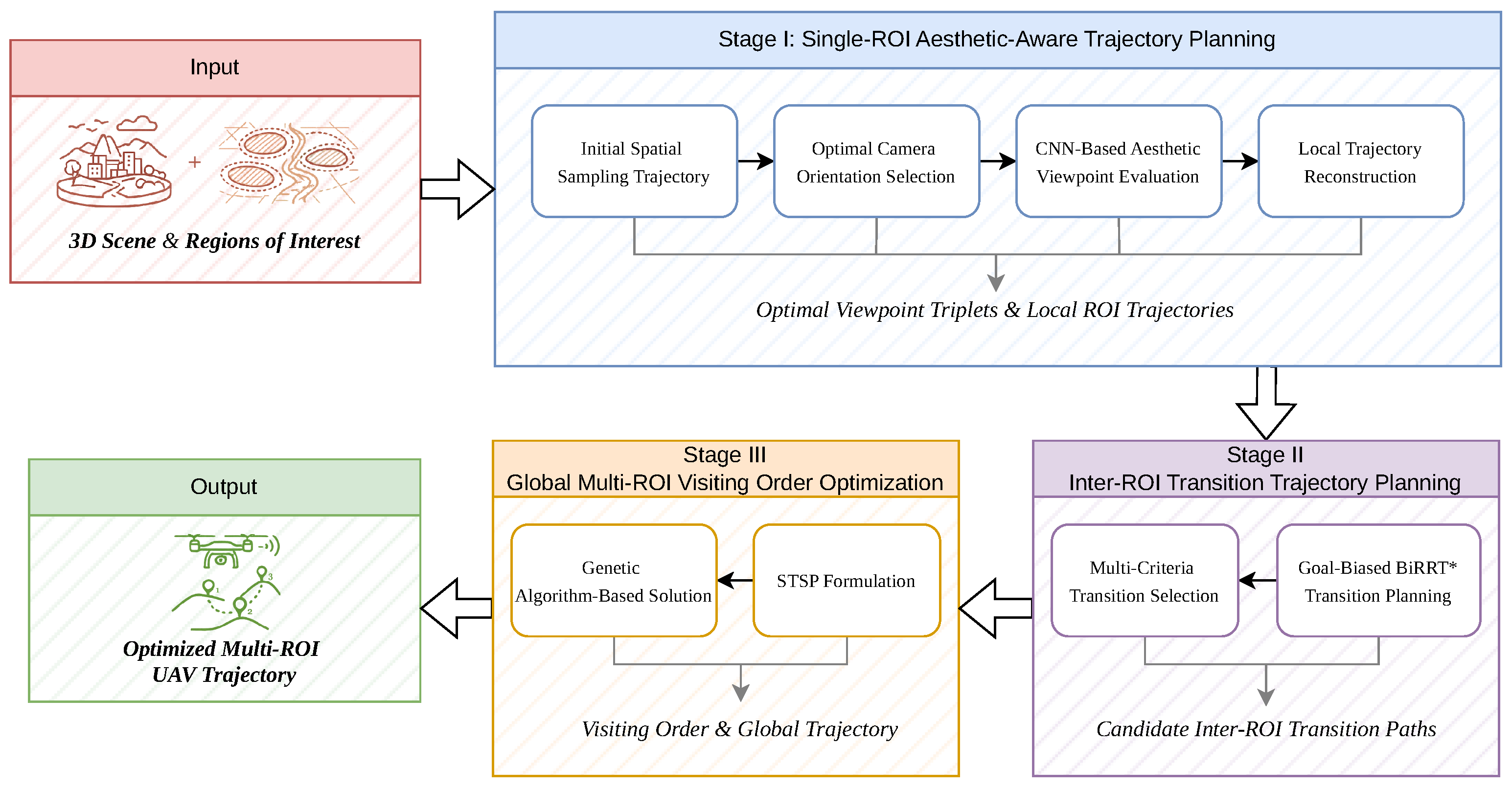
Figure 1 illustrates the overall workflow of the proposed UAV trajectory planning framework.
As illustrated in Figure 1, the proposed framework consists of three coordinated planning stages. Stage I performs single-ROI aesthetic-aware trajectory planning, where candidate viewpoints are generated and optimized according to visual composition quality and motion feasibility. Stage II performs inter-ROI transition trajectory planning using the Goal-biased BiRRT* algorithm to generate collision-free transition paths between ROIs in cluttered environments. Finally, Stage III formulates the global multi-ROI visiting order optimization problem as a STSP to determine an efficient global filming sequence.
Unlike conventional UAV cinematography approaches that separately optimize camera viewpoints and flight trajectories, the proposed framework jointly integrates aesthetic evaluation, local trajectory generation, inter-ROI transition planning, and global route organization within a unified hierarchical planning pipeline. From a system perspective, the proposed framework emphasizes the coordinated hierarchical formulation and system-level integration of these planning stages for autonomous UAV cinematography, rather than proposing entirely new low-level optimization algorithms. The current framework mainly focuses on offline or semi-offline multi-ROI UAV cinematography planning in relatively static environments, where high-quality trajectory generation and visual coherence are prioritized over fully real-time autonomous operation.
First, within each ROI, an initial spatial sampling trajectory is generated using a spiral-ascent sampling strategy. For each sampled position, the optimal camera orientation is selected to form candidate viewpoints. A convolutional neural network (CNN)-based aesthetic evaluation model is then employed to assess the visual quality of candidate viewpoints. Based on the evaluation results and a comprehensive cost function, an optimal set of viewpoints is selected. Accordingly, a local UAV trajectory is reconstructed from the selected viewpoints to generate an aesthetics-aware trajectory within the ROI while jointly considering visual composition quality and motion feasibility.
After obtaining local trajectories for individual ROIs, smooth transitions between different ROIs are generated. Specifically, a Goal-biased Bidirectional Rapidly exploring Random Tree Star (Goal-biased BiRRT*) algorithm is employed to produce multiple candidate transition trajectories between ROIs. An optimal transition path is then selected according to a multi-criteria cost evaluation.
Finally, the global visiting order of ROIs is formulated as a STSP. A genetic algorithm is adopted to solve the STSP and determine an efficient visiting sequence among ROIs. By integrating local ROI trajectories, inter-ROI transition trajectories, and optimized global visiting order organization within a coordinated hierarchical planning architecture, the proposed framework achieves autonomous multi-ROI UAV cinematography with improved visual continuity, planning autonomy, and global trajectory coherence.
The detailed implementations of each stage are described in the following subsections.

3.2. Single-ROI Aesthetic-Aware Trajectory Planning

3.2.1. Initial Spatial Sampling Trajectory for a Single ROI

To enable multi-view observation of the target region, each region of interest is abstracted as a cylindrical volume, and a spiral ascent trajectory is adopted as the initial UAV flight path. Considering the high-fidelity rendering capability of Unreal Engine 5 (UE5) and the UAV simulation support provided by AirSim, a virtual aerial cinematography environment is constructed to validate the proposed method in a safe and controllable manner [34,35].
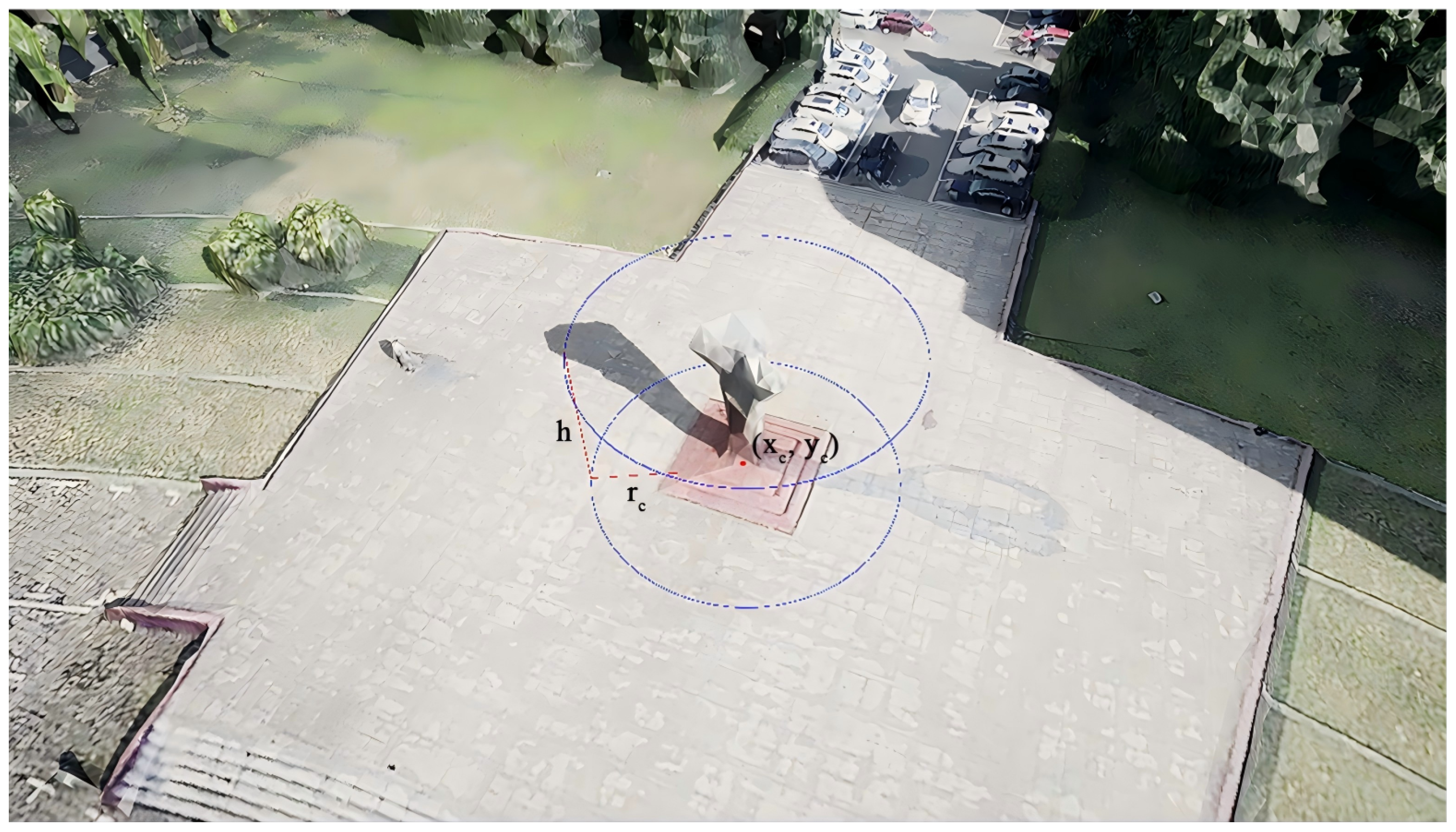
As illustrated in Figure 2, the ROI is parameterized by the ground center coordinate ( x c , y c ) , the cylinder radius r c , and the height h.
In the current framework, the geometric characteristics of the ROI, including its approximate spatial extent and height information, are assumed to be obtained from prior scene information, user annotations, or reconstructed scene geometry. Moderate uncertainty in the ROI dimensions may influence the generated sampling radius, altitude bounds, and viewpoint distribution density, thereby affecting local composition stability and trajectory compactness. However, since the proposed framework adopts multi-view spatial sampling together with subsequent viewpoint evaluation and optimization, moderate geometric deviations can still be partially compensated during the viewpoint selection stage. The current work mainly focuses on relatively static environments with reasonably accurate ROI estimation. Future work will further investigate uncertainty-aware adaptive viewpoint sampling and trajectory adjustment mechanisms for more robust autonomous UAV cinematography in complex real-world scenarios.
  • Flight Radius Determination
    According to the rule-of-thirds composition principle, the main subject should occupy at least one-third of the image dimension. Based on the horizontal and vertical camera fields of view, the maximum observation distances can be computed.
    Let W and H denote the width and height of the ROI, and let F O V h and F O V v represent the horizontal and vertical camera field-of-view angles. The maximum horizontal and vertical observation distances are
    D h = 3 W 2 tan F O V h 2 ,
    D v = 3 H 2 tan F O V v 2 .
    The orbital flight radius is then determined as
    D c = r c + max ( D h , D v ) ,
    where r c denotes the radius of the cylindrical ROI.
  • Altitude Bounds
    To ensure that the bottom of the ROI remains visible in the captured image while considering the practical constraint of camera pitch, the minimum flight altitude is derived as
    h m i n H m i n + 2 3 ( D c r c ) tan F O V v 2 ,
    where H m i n denotes the height of the ROI bottom.
    Similarly, when the UAV is located above the ROI center and the camera is oriented downward, the maximum flight altitude satisfying the composition constraint is
    h m a x = H m a x + 3 r c tan F O V h 2 ,
    where H m a x denotes the height of the ROI top.
  • Spiral Sampling Trajectory Generation
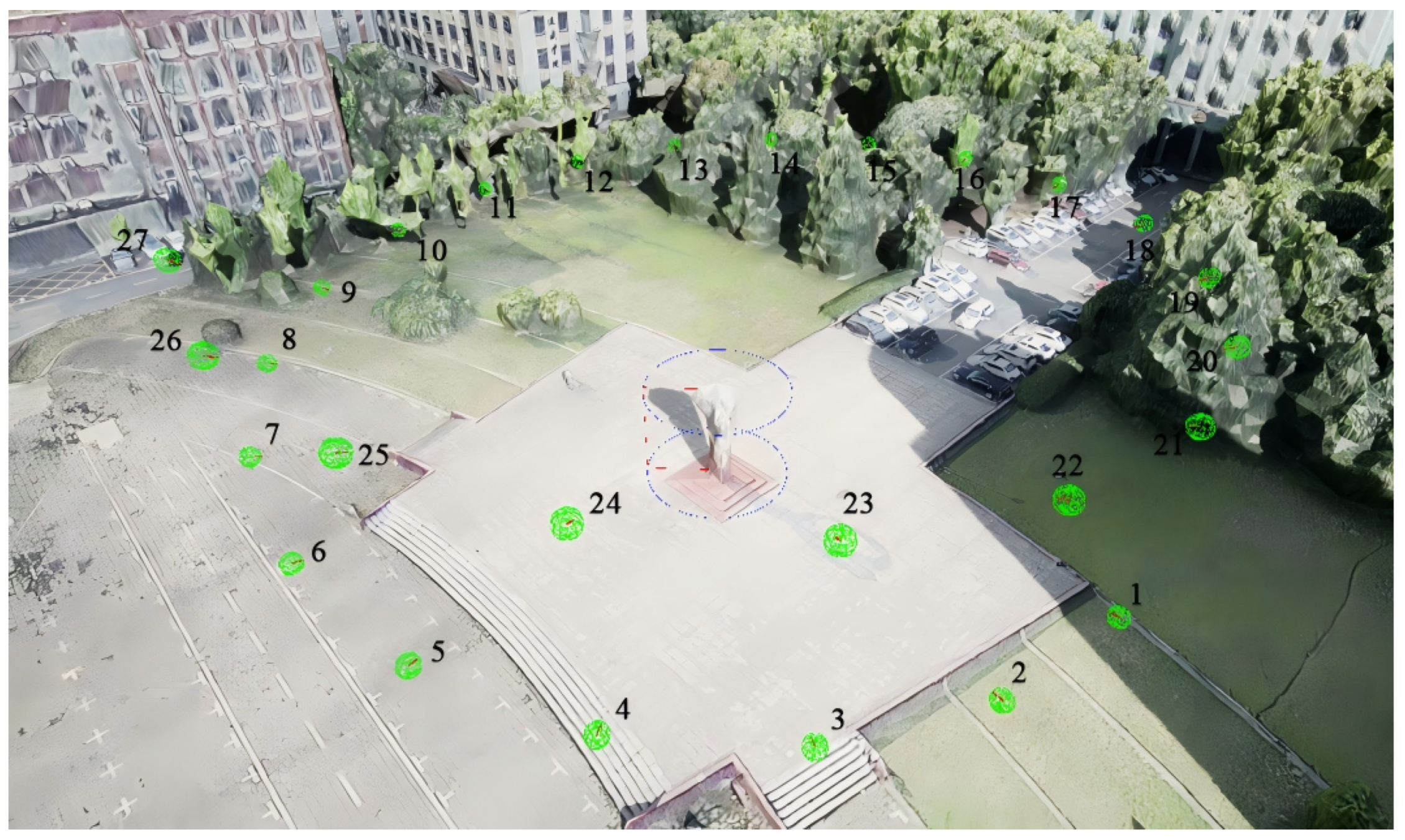
    Based on the derived orbital radius and altitude bounds, a multi-layer spiral ascent trajectory is constructed to generate candidate sampling viewpoints around the ROI. The trajectory center coincides with the cylindrical axis of the ROI, and the altitude increases gradually from h m i n to h m a x .
    Let Δ θ denote the angular increment between consecutive sampling points. The coordinates of the i-th sampling point p i = ( x i , y i , z i ) are defined as
    x i = ( D c + D s ) cos ( θ i ) + x c , y i = ( D c + D s ) sin ( θ i ) + y c , z i = h i ,
    where D s denotes an additional safety margin, θ i = θ 0 + i Δ θ is the azimuth angle of the sampling point, θ 0 is the initial angle, and h i is the corresponding altitude.
    During flight, the camera continuously faces the ROI center to ensure that the target remains within the central region of the image frame. The resulting spiral trajectory provides a structured set of candidate viewpoints for subsequent viewpoint evaluation and trajectory optimization, as illustrated in Figure 3.

3.2.2. Composition View Generation and Optimal Viewpoint Selection

Based on the spiral sampling trajectory generated in the previous subsection, an optimal camera orientation is determined for each sampling point such that the ROI is placed at aesthetically favorable locations in the image plane.
In this work, the UAV is assumed to carry a three-axis gimballed camera whose orientation can be adjusted independently from the UAV body attitude within practical mechanical limits. The UAV trajectory primarily controls the spatial motion of the platform, while the gimbal is responsible for camera orientation adjustment during viewpoint generation and composition optimization. Therefore, each viewpoint is represented by the joint state consisting of the UAV spatial position and the associated gimbal camera orientation.
To achieve this, a set of predefined ideal composition anchors is introduced, and a composite cost function combining composition alignment and visibility constraints is constructed.
  • Ideal Composition Points
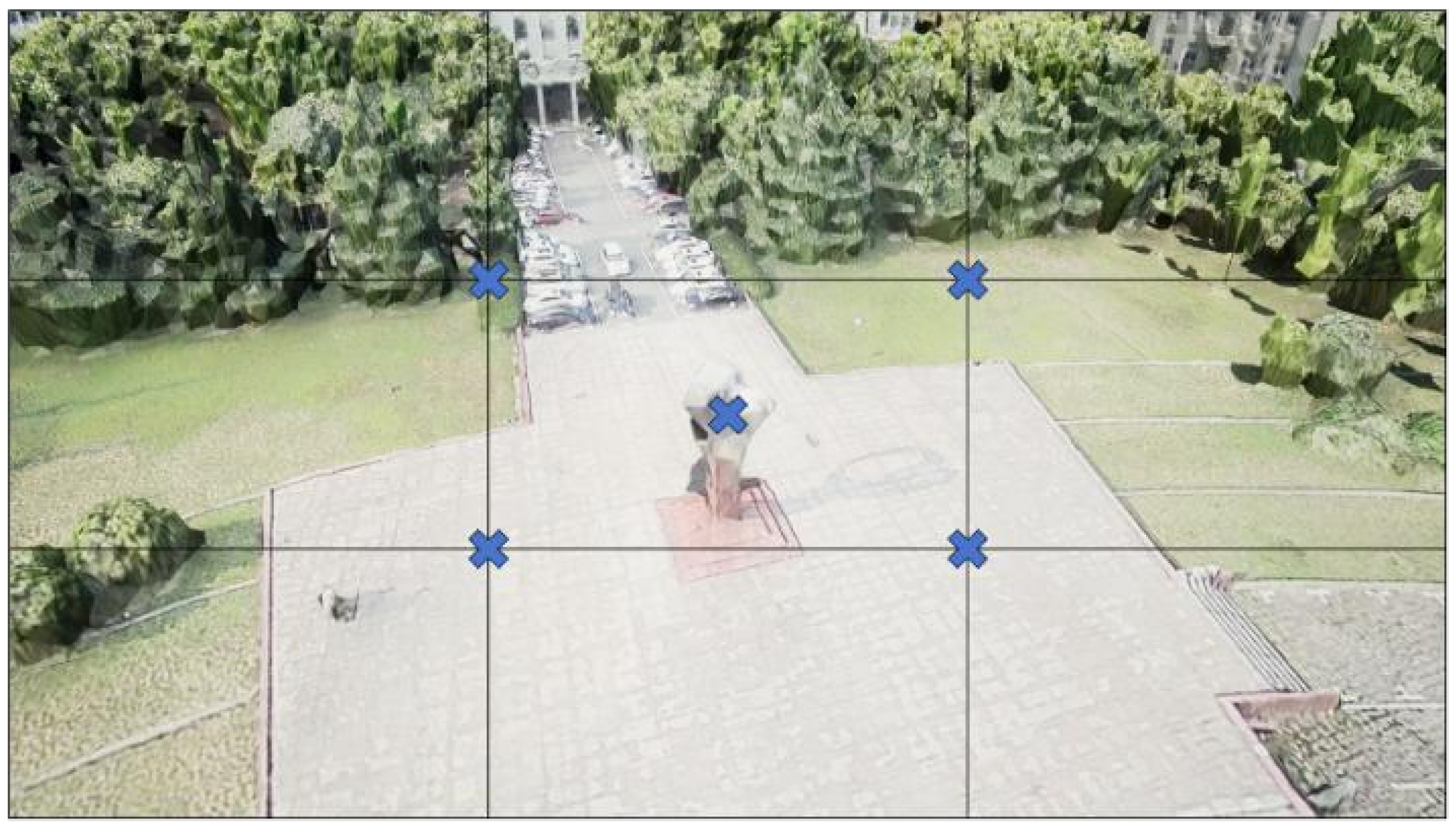
    According to the rule-of-thirds composition principle, five commonly used framing anchors are considered: the image center and the four rule-of-thirds intersection points. These anchors form the candidate composition set
    P i d e a l = { p c e n t e r , p t o p l e f t , p t o p r i g h t , p b o t t o m l e f t , p b o t t o m r i g h t } .
    As illustrated in Figure 4, these anchors serve as candidate targets for camera orientation optimization.
  • Framing Cost
    The framing cost measures the deviation between the projected ROI center and the ideal composition anchors. Let p c u r r e n t denote the projection of the ROI center in the image plane. Its normalized camera coordinate is
    p c u r r e n t n o r m = K 1 p c u r r e n t ,
    where K is the camera intrinsic matrix. Similarly, the normalized coordinate of an ideal anchor p i is
    p i n o r m = K 1 p i .
    The framing cost is defined as
    C f r a m i n g = p c u r r e n t n o r m p i n o r m 2 2 .
  • Visibility Cost
    To prevent the ROI from being truncated by image boundaries, a visibility constraint is introduced. Let d l e f t , d r i g h t , d t o p , and d b o t t o m denote the distances from the ROI bounding box to the image borders. A zoom factor is defined as
    α = max d t h r e s h o l d d l e f t , d t h r e s h o l d d r i g h t , d t h r e s h o l d d t o p , d t h r e s h o l d d b o t t o m .
    The visibility cost is then defined as
    C v i s i b i l i t y = 0 , α 1 λ ( α 1 ) , α > 1 .
    where λ is a weighting parameter controlling the penalty strength of visibility violation. Since both the framing cost and the visibility penalty are defined on normalized image-plane coordinates, their magnitudes are generally within the order of O ( 1 ) . Accordingly, λ is empirically selected within the same order of magnitude to maintain a balanced contribution between composition alignment and visibility preservation.
  • Optimal Composition View Selection
    The overall cost is defined as
    C t o t a l = ω 1 C f r a m i n g + ω 2 C v i s i b i l i t y .
    For each sampling point, the composite cost is evaluated for all candidate composition anchors, and the orientation yielding the minimum cost is selected as the optimal composition view.
    The camera orientation required to align the ROI with the selected composition anchor can then be analytically derived from the geometric relationship between the current ROI projection and the target image-plane position. Each sampling position together with its optimal camera orientation forms a candidate viewpoint, which is subsequently used for viewpoint evaluation and trajectory generation.

3.2.3. CNN-Based Aesthetic Viewpoint Evaluation

After determining the optimal composition view for each sampling point, the visual quality of candidate viewpoints must be quantitatively evaluated. To this end, a convolutional neural network (CNN)-based aesthetic assessment model is introduced to automatically estimate the aesthetic quality of captured views.
In practice, for each sampled viewpoint, a rendered image is generated in the simulation environment and fed into the aesthetic evaluation network. The predicted aesthetic score is then used as a quantitative metric for viewpoint evaluation and is further integrated into the trajectory optimization process.
  • Teacher Aesthetic Model
    The teacher model is built upon the ReLIC++ aesthetic evaluation framework proposed by Zhao et al. [36], with MobileNetV2 adopted as the backbone network for visual feature extraction [37,38].
    The architecture adopts a dual-branch design to jointly capture global and local aesthetic cues:
    1.
    Global perception branch: extracts holistic visual representations through global average pooling, capturing global composition layout, lighting distribution, and color harmony.
    2.
    Self-attention branch: models spatial relationships between image regions using attention mechanisms, enhancing the representation of local composition structures.
    By combining global and local representations, the teacher model can effectively learn comprehensive aesthetic features of images.
  • Lightweight Student Model
    To enable efficient inference in real-time 3D environments such as Unreal Engine, a lightweight aesthetic evaluation network termed LightNIMA is designed. The model inherits the score distribution prediction mechanism of the Neural Image Assessment (NIMA) framework proposed by [39], which represents image aesthetics using a probability distribution over multiple rating levels. To adapt this concept to real-time UAV trajectory planning, the network is further simplified through backbone truncation and knowledge distillation.
    Given an input image I, the student network first extracts visual features using a truncated MobileNetV2 backbone, where only the first nine layers are retained to reduce computational overhead. Based on these features, the LightNIMA architecture contains three lightweight modules:
    1.
    Lightweight feature extraction: depthwise separable convolution blocks are employed to further process feature maps, significantly reducing the number of parameters while maintaining feature representation capability.
    2.
    Statistical feature aggregation: global statistics, including maximum, minimum, mean, and standard deviation values of feature maps, are computed to obtain compact global descriptors.
    3.
    Lightweight regression head: a shallow fully connected network predicts the aesthetic score distribution of the input image.
    The network outputs a 10-dimensional aesthetic score distribution
    a = [ a 1 , a 2 , , a 10 ] ,
    where a i denotes the probability that the image receives a score of i. This probabilistic representation follows the NIMA paradigm and provides a more expressive description of aesthetic perception compared with single-score prediction.
  • Knowledge Distillation Training
    To preserve the perceptual capability of the teacher model while maintaining efficiency, a multi-objective knowledge distillation strategy is employed. During training, each input image is simultaneously fed into both the teacher and student networks. The student model is optimized to match the teacher outputs through several distillation objectives.
    The overall training loss is defined as
    L t o t a l = η L K L + ( 1 η ) L a t t n + γ L m i d
    where η controls the balance between score distribution alignment and attention consistency, L K L aligns the predicted score distributions, L a t t n enforces consistency between attention maps, and L m i d matches intermediate feature representations.
    The three distillation objectives provide complementary knowledge transfer constraints at different representation levels. Specifically, L K L aligns the global aesthetic score distributions between the teacher and student models through soft-label distillation, enabling the student network to preserve high-level aesthetic judgment capability. L a t t n enforces consistency between spatial attention maps, which helps the student model focus on visually important regions related to composition and saliency. Meanwhile, L m i d constrains intermediate feature representations and improves semantic feature consistency during knowledge transfer. By jointly optimizing these objectives, the student model is able to retain essential perceptual and compositional capabilities of the teacher network while maintaining lightweight computational complexity suitable for real-time viewpoint evaluation.
  • Datasets and Training Strategy
    The model is trained on a mixture of the AVA dataset [40] and the BAID dataset [41]. AVA contains 255,530 photographs with aesthetic scores from 1 to 10, capturing photographic composition and lighting characteristics. BAID contains 60,337 artworks from the Boldbrush community, covering diverse artistic styles.
    A 1:1 mixture of AVA and BAID samples is used for training to enhance cross-domain aesthetic perception capability.
    It should be noted that although the AVA and BAID datasets are not specifically designed for UAV aerial cinematography, they contain large numbers of photographic and artistic samples that capture general aesthetic principles such as composition balance, rule of thirds, visual saliency, leading lines, and color harmony.
    Since the proposed framework mainly focuses on viewpoint-level composition quality evaluation rather than high-level cinematic editing semantics or temporal rhythm modeling, these general visual aesthetic characteristics still provide a meaningful basis for UAV viewpoint assessment.
    Rather than modeling high-level cinematic semantics or professional film editing styles, the proposed aesthetic evaluation model mainly focuses on viewpoint-level visual composition quality assessment, including composition balance, target placement, spatial saliency, and visual harmony. Therefore, general-purpose photographic and artistic datasets can still provide useful supervision for learning transferable low-level and mid-level aesthetic representations applicable to UAV viewpoint evaluation.
    Nevertheless, domain discrepancies between ground-level photography and aerial cinematography still exist due to differences in viewing perspectives, scene scales, and motion characteristics. The current framework does not explicitly perform aerial-specific domain adaptation or fine-tuning because of the limited availability of large-scale UAV cinematography aesthetic datasets with reliable subjective annotations. As a result, certain domain biases may still exist in complex aerial filming scenarios.
    Future work will investigate aerial-specific aesthetic datasets, transfer learning strategies, and cross-domain adaptation techniques to further improve the robustness and generalization capability of the aesthetic evaluation model in UAV cinematography applications.
  • Viewpoint Aesthetic Scoring
    For each candidate viewpoint generated along the sampling trajectory, the rendered image is fed into the trained LightNIMA network to obtain the aesthetic score distribution. The expected aesthetic score can be further computed as a scalar metric to evaluate viewpoint quality. This score is subsequently used to rank candidate viewpoints and guide the trajectory optimization process.

3.2.4. Optimal Viewpoint Set Selection and Local Trajectory Reconstruction

After the viewpoint generation and CNN-based aesthetic evaluation stages, a candidate viewpoint pool has been obtained for each ROI. Specifically, each candidate viewpoint generated along the spiral sampling trajectory has already been associated with its corresponding aesthetic score distribution and expected aesthetic score predicted by the LightNIMA network. These evaluated candidate viewpoints are subsequently used for viewpoint subset selection and local trajectory reconstruction.
Within each ROI, an optimal subset of viewpoints is selected to balance aesthetic quality and spatial coverage. Given a set of candidate viewpoints generated in the previous steps, our strategy first constructs candidate viewpoint triplets based on coverage, viewpoint distribution, and aesthetic scores. Local trajectories are then reconstructed for each triplet and evaluated using multiple criteria. The best-performing triplet is finally selected as the optimal viewpoint set, and its corresponding trajectory is regarded as the optimal local flight path.
  • Candidate Triplet Generation
    To ensure that the ROI can be observed from diverse directions, candidate viewpoints must satisfy spatial coverage constraints. For a cylindrical ROI with radius r c , if a viewpoint V i is located at distance D i from the ROI center, its horizontal coverage angle is defined as
    θ i = 2 arctan r c D i .
    By merging the coverage intervals of all viewpoints, the overall azimuth coverage of the ROI can be estimated. Only viewpoint combinations that provide sufficient coverage are retained as valid candidates.
    In addition, viewpoint distance constraints are imposed to avoid redundant observations and excessively long trajectories. Based on the CNN-based aesthetic evaluation model described in the previous subsection, viewpoints with aesthetic score a i lower than a threshold are discarded.
    All valid viewpoint triplets are collected as
    V = { ( V 1 1 , V 2 1 , V 3 1 ) , , ( V 1 M , V 2 M , V 3 M ) } ,
    where M denotes the number of candidate triplets.
  • Triplet Evaluation
    To jointly evaluate spatial coverage and aesthetic quality, a composite scoring function is defined for each viewpoint triplet:
    S ( V 1 , V 2 , V 3 ) = λ 1 S coverage + λ 2 i = 1 3 a i ,
    where S coverage measures the coverage completeness of the ROI, a i is the aesthetic score predicted by the CNN model, and λ 1 , λ 2 are weighting coefficients.
    Triplets are ranked according to this score, and the top candidates are retained for trajectory reconstruction.
  • Local Trajectory Reconstruction
    For each candidate viewpoint triplet ( V 1 , V 2 , V 3 ) , a local flight trajectory is generated using a quintic B-spline representation to ensure smooth and dynamically feasible motion.
    The trajectory is represented as
    P ( t ) = i = 0 n N i , p ( t ) P i ,
    where N i , p ( t ) denotes the p-th order B-spline basis function and P i denotes the control points. The selected viewpoints serve as the primary control points, while additional control points are generated through interpolation and extrapolation to ensure trajectory continuity.
  • Trajectory Optimization
    All reconstructed trajectories are first checked for feasibility through collision detection. Only collision-free trajectories are retained for further optimization.
    In the current framework, obstacle information is assumed to be available in advance from the reconstructed 3D environment used in the simulation platform. The considered obstacles mainly include static scene structures such as buildings, terrain surfaces, trees, and other large environmental objects. During trajectory validation, sampled trajectory points and interpolated trajectory segments are checked against the collision geometry of the scene to ensure that the generated trajectories remain collision-free and dynamically feasible.
    The current work mainly focuses on offline or semi-offline UAV cinematography planning in relatively static environments. Therefore, dynamic obstacles such as pedestrians or moving vehicles are not explicitly modeled in the present framework. Handling dynamic obstacle avoidance and online trajectory replanning will be investigated in future work.
    A multi-objective cost function is then defined to jointly evaluate trajectory length, viewpoint quality, and motion smoothness:
    E total = β 1 E length + β 2 E quality + β 3 E smooth ,
    where E length measures the overall trajectory length to encourage efficient flight paths, E quality evaluates the average aesthetic quality of sampled viewpoints along the reconstructed trajectory based on the CNN-predicted aesthetic scores, and E smooth penalizes excessive trajectory curvature variation to encourage smooth and dynamically feasible UAV motion.
    In the current framework, trajectory smoothness mainly corresponds to the geometric continuity and curvature consistency of the reconstructed B-spline trajectory, thereby reducing abrupt turning behaviors and improving motion stability during aerial cinematography.
    The trajectory with the minimum total cost is selected as the optimal local trajectory for the ROI, ensuring safe, efficient, and aesthetically optimized aerial cinematography.

3.3. Inter-ROI Transition Trajectory Planning

3.3.1. Goal-Biased BiRRT* Transition Trajectory Generation

In complex environments, multiple feasible transition trajectories may exist between any pair of ROIs, while the presence of obstacles further increases the difficulty of safe UAV navigation. To efficiently generate feasible paths in such cluttered environments, a Goal-biased BiRRT* algorithm is employed for inter-ROI transition trajectory generation.
In the current framework, the considered cluttered environments mainly contain complex static obstacles such as buildings, terrain structures, trees, and other large scene objects reconstructed in the simulation environment. The obstacle locations are assumed to be known in advance from the prebuilt 3D scene representation used for offline or semi-offline UAV cinematography planning.
Under such environments, conventional uniform-sampling planners may suffer from low exploration efficiency and poor convergence in narrow free-space regions. Therefore, the Goal-biased BiRRT* framework is adopted to improve path exploration efficiency, trajectory feasibility, and collision-free connectivity in complex static environments.
The algorithm follows a bidirectional RRT framework in which two search trees are simultaneously expanded from the start and goal configurations [42]. During the exploration process, the two trees attempt to connect while applying the RRT* rewiring mechanism to continuously improve path quality.
To further improve planning efficiency and trajectory quality in complex environments, three optimization mechanisms are introduced.
  • Heuristic Sampling Strategy
    Uniform random sampling used in conventional RRT planners is inefficient in cluttered environments. To address this limitation, a heuristic non-uniform sampling strategy is introduced:
    p heuristic ( x ) = ρ 1 p conn ( x ) + ρ 2 p narrow ( x ) + ( 1 ρ 1 ρ 2 ) p uniform ( x )
    where p conn ( x ) biases sampling toward the region between the two trees, p narrow ( x ) focuses sampling on narrow passages, and p uniform ( x ) denotes global uniform sampling. This strategy improves exploration efficiency while maintaining global coverage.
  • Dynamic Goal Biasing
    Instead of using a fixed goal bias probability, the goal sampling probability is dynamically adjusted according to the planning progress:
    p goal = 0.7 p goal 0 , i i max < 0.3 p goal 0 f ( r succ ) , 0.3 i i max 0.7 min ( 0.5 , 1.5 p goal 0 ) , i i max > 0.7
    where i is the current iteration index, i max is the maximum iteration number, and r succ denotes the sampling success rate. This adaptive strategy balances exploration and exploitation during different search stages.
  • Adaptive Connection Threshold
    In bidirectional RRT planners, the connection threshold determines when the two trees attempt to connect. To adapt to different environment complexities, an adaptive connection threshold is introduced:
    δ conn ( i ) = δ conn 0 1 + 0.5 i i max g ( r succ )
    This mechanism dynamically adjusts the connection condition based on search progress and environmental feedback, improving the success rate of tree connections and the smoothness of the generated trajectories.
With these three optimization mechanisms—heuristic sampling, dynamic goal biasing, and adaptive connection threshold adjustment—the Goal-biased BiRRT* algorithm can efficiently generate smooth and feasible transition trajectories between ROIs in complex environments.

3.3.2. Multi-Criteria Evaluation and Optimal Path Selection

The transition trajectories generated by the Goal-biased BiRRT* planner are typically composed of discrete waypoints and may contain redundant nodes and unnecessary turning motions. Therefore, an additional smoothing and multi-criteria evaluation process is performed to obtain the optimal inter-ROI transition trajectory.
  • Trajectory Smoothing and Feasibility Processing
    For each candidate transition path, the discrete waypoints are first extracted as initial control points. A B-spline curve is then employed to reconstruct a smooth trajectory with improved continuity and executability:
    P ( t ) = i = 0 n N i , p ( t ) P i
    where N i , p ( t ) denotes the B-spline basis function and P i denotes the control points.
    After smoothing, the reconstructed trajectory is further checked for feasibility, including collision avoidance and motion continuity. If collisions are detected, the control points are adjusted and the smooth trajectory is regenerated. If excessive turning motions are observed, local refinement is applied to improve continuity and smoothness.
  • Transition Cost Evaluation
    For a candidate transition trajectory T m , m connecting ROI m and ROI m , a multi-criteria cost is defined based on the following factors:
    1.
    Path length cost, which constrains flight time and energy consumption;
    2.
    Viewpoint quality cost, which evaluates the aesthetic quality of sampled viewpoints along the transition using the CNN-based model;
    3.
    Camera orientation change cost, which penalizes abrupt changes in camera direction;
    4.
    Turning smoothness cost, which measures directional continuity when entering and leaving ROIs;
    5.
    Altitude change cost, which discourages abrupt vertical transitions.
    The overall transition cost is defined as
    E trans = κ 1 E length + κ 2 E quality + κ 3 E rot + κ 4 E turn + κ 5 E height
    where κ 1 , , κ 5 are weighting coefficients.
    The weighting coefficients are selected to balance multiple competing objectives during transition trajectory generation. In the current framework, relatively larger weights are assigned to viewpoint quality and turning smoothness terms to encourage visually coherent and cinematographically smooth UAV motion, while path length and altitude variation terms mainly serve as auxiliary constraints for flight efficiency and trajectory stability.
    Specifically, increasing the viewpoint quality weight tends to favor trajectories containing more aesthetically favorable viewpoints, whereas increasing the turning smoothness weight suppresses abrupt directional changes and improves motion continuity between ROIs. Meanwhile, larger path length or altitude variation weights encourage shorter and more energy-efficient transitions but may reduce trajectory flexibility in cluttered environments. The final weighting configuration was determined empirically through iterative qualitative evaluation across multiple representative UAV cinematography scenarios.
  • Optimal Path Selection
    The total cost is computed for all candidate transition trajectories, and the trajectory with the minimum cost is selected as the optimal path between ROI m and ROI m . This multi-criteria evaluation strategy provides a balanced trade-off among flight efficiency, visual quality, and motion smoothness, and supplies reliable edge costs for the subsequent global visiting order optimization.

3.4. Global Multi-ROI Visiting Order Optimization

In the previous stage, candidate transition trajectories between ROIs were generated and evaluated, and the optimal connection between each ROI pair was determined. Based on these locally optimal connections, the remaining task is to determine the visiting order of all ROIs to obtain the globally optimal UAV cinematography route.
The global planning stage aims to:
  • Visit all ROIs and complete the corresponding cinematography tasks;
  • Ensure smooth transitions between consecutive local ROI trajectories;
  • Minimize the overall flight cost while satisfying feasibility constraints.
To achieve these objectives, the global route optimization problem is formulated as a Set Traveling Salesman Problem and solved using a Genetic Algorithm (GA). Through iterative evolution, the algorithm identifies an ROI visiting order that balances flight efficiency, path length, and cinematic continuity, thereby producing an optimized global flight trajectory for multi-ROI aerial cinematography.

3.4.1. STSP Formulation for Multi-ROI Cinematography

In the STSP formulation, each ROI is represented as a node set consisting of an entry node and an exit node. The global navigation problem can therefore be represented as a directed weighted graph
G = ( V , E )
where the vertex set includes the global start and end nodes as well as all entry and exit nodes of the ROIs.
If a feasible transition trajectory exists between nodes i and j, a directed edge ( i , j ) is created with weight E trans ( i , j ) , which corresponds to the transition trajectory cost obtained in the previous stage.
The objective of the global planning problem is to determine the visiting order of all ROIs and the corresponding entry/exit selections that minimize the total transition cost:
min E global = E trans ( i , j ) .
This formulation jointly models the ROI visiting sequence and the transition costs between ROIs.

3.4.2. Genetic Algorithm-Based Solution for Global Path Optimization

To efficiently solve the formulated STSP problem, a Genetic Algorithm is adopted for global optimization.
Each chromosome represents a candidate ROI visiting sequence together with the corresponding entry/exit node selections. The GA iteratively improves candidate solutions through population evolution.
  • Population Initialization
    The initial population is generated by randomly permuting the ROI visiting order and randomly assigning entry and exit nodes, ensuring sufficient diversity in the search space.
  • Fitness Evaluation
    The fitness of a candidate route P is defined as the reciprocal of its global path cost:
    Fitness ( P ) = 1 E global ( P ) .
    Routes with lower cost therefore obtain higher fitness values.
  • Evolutionary Operations
    Selection, crossover, and mutation operations are applied to generate new candidate routes and explore the solution space while avoiding premature convergence.
  • Global Route Construction
    After convergence, the best chromosome represents the optimal ROI visiting order and the corresponding entry/exit node configuration. The final global trajectory is constructed by concatenating local ROI trajectories with the optimal inter-ROI transition trajectories.
Through this optimization process, a globally efficient and visually coherent UAV cinematography route covering all ROIs is obtained.

4. Experiments and Analysis

To systematically evaluate the effectiveness and practicality of the proposed UAV cinematography trajectory planning framework, a series of experiments were conducted in several virtual three-dimensional environments. The experiments aim to analyze the performance of the proposed method from multiple aspects, including single-ROI local trajectory generation, inter-ROI transition trajectory planning, and global route optimization. In addition, comparative algorithm experiments, user subjective evaluations, and computational performance analysis are carried out to assess the proposed framework from the perspectives of path quality, visual aesthetics, and system feasibility.

4.1. Experimental Setup

To evaluate the performance of the proposed UAV cinematography trajectory planning framework, a set of experiments was conducted in several representative virtual environments. All experiments were performed in a three-dimensional simulation environment built with Unreal Engine 5.4.4. The experiments were executed on a workstation running Windows 11, equipped with an Intel i9-12900K CPU, 64 GB RAM, and an NVIDIA RTX 4070 Super GPU.
Three representative test environments were used in the experiments: the Wuhan University campus scene, the Central Park scene in New York, and the Chibi scenic area scene. These environments contain different types of buildings, vegetation distributions, and spatial layouts, allowing the evaluation of the proposed method under environments with varying levels of structural complexity. In each scene, multiple ROIs were defined to simulate multi-target aerial cinematography tasks.
To comprehensively evaluate the performance of the proposed method, several metrics were adopted in the experiments. These metrics include planning time, path length, success rate, number of nodes, and minimum clearance from obstacles, which are used to evaluate the efficiency, path quality, and safety of the planned trajectories. In addition, for experiments involving visual quality evaluation, the aesthetic scores of captured viewpoints were predicted using the CNN-based aesthetic evaluation model to quantify the visual quality of different trajectories.

4.2. Single-ROI Cinematography Evaluation

To evaluate the effectiveness of the proposed single-ROI trajectory generation method, experiments were conducted from three perspectives: viewpoint aesthetic response analysis, student model performance evaluation, and comparison of local trajectory generation methods.

4.2.1. Viewpoint Aesthetic Response Analysis

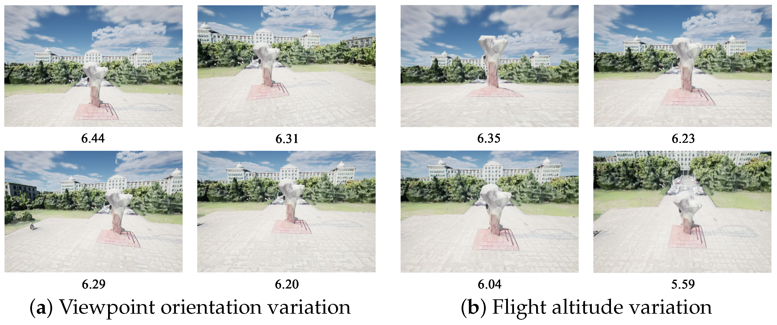
To analyze the sensitivity of the proposed student model to viewpoint variations, we first examine the predicted aesthetic scores under different camera orientations while keeping the UAV position fixed. As shown in Figure 5a, the predicted aesthetic score reaches approximately 6.44 when the camera orientation corresponds to the optimal composition viewpoint, where the subject is located near the rule-of-thirds intersections and the visual balance of the scene is well maintained.
When the viewpoint slightly deviates from the optimal orientation, the score decreases to 6.31, and further deviations lead to a score of 6.20. This trend indicates that as the subject gradually moves away from the ideal composition region, the visual balance and attractiveness of the image decrease, resulting in lower aesthetic scores.
A similar experiment was conducted by varying the UAV altitude while maintaining the same horizontal position, as illustrated in Figure 5b. The optimal altitude yields an aesthetic score of approximately 6.35, while higher flight altitudes gradually reduce the score to 5.59. This phenomenon can be explained by the increasing top-down viewing angle, which makes the subject appear smaller and weakens the spatial depth of the scene.
These results demonstrate that the proposed student model can effectively capture aesthetic variations caused by viewpoint and altitude changes, providing useful guidance for selecting optimal UAV viewpoints in automated aerial cinematography.
Although the aesthetic evaluation model is trained on general-purpose photographic and artistic datasets rather than aerial-specific cinematography datasets, the qualitative experimental results in UAV aerial cinematography scenes demonstrate that the model can still provide visually reasonable viewpoint preferences under different viewing angles and flight altitudes. This observation suggests that general visual aesthetic principles learned from AVA and BAID, such as composition balance and visual saliency, remain partially transferable to UAV viewpoint evaluation. Nevertheless, domain discrepancies between ground-level photography and aerial cinematography still exist, and future work will further investigate aerial-specific dataset construction and cross-domain adaptation strategies to improve model generalization capability.

4.2.2. Student Model Performance Evaluation

To quantitatively evaluate the accuracy preservation and computational efficiency of the proposed lightweight student model, 40 images of the target object were collected from different viewpoints in a simulated environment. These images were evaluated using both the teacher model and the student model.
The results in Table 2 show that the student model maintains high consistency with the teacher model while significantly reducing computational cost. The Pearson correlation coefficient between the two models is r = 0.9461 , and the Spearman rank correlation coefficient is ρ = 0.9030 , indicating that the student model successfully inherits the aesthetic evaluation capability of the teacher model.
In terms of efficiency, the student model achieves a 68% improvement in inference speed and reduces the model size by approximately 93%. Although the student model exhibits slightly larger prediction errors in terms of MAE and RMSE, the error magnitude remains acceptable for real-time UAV cinematography applications.

4.2.3. Comparison of Local Trajectory Generation Methods

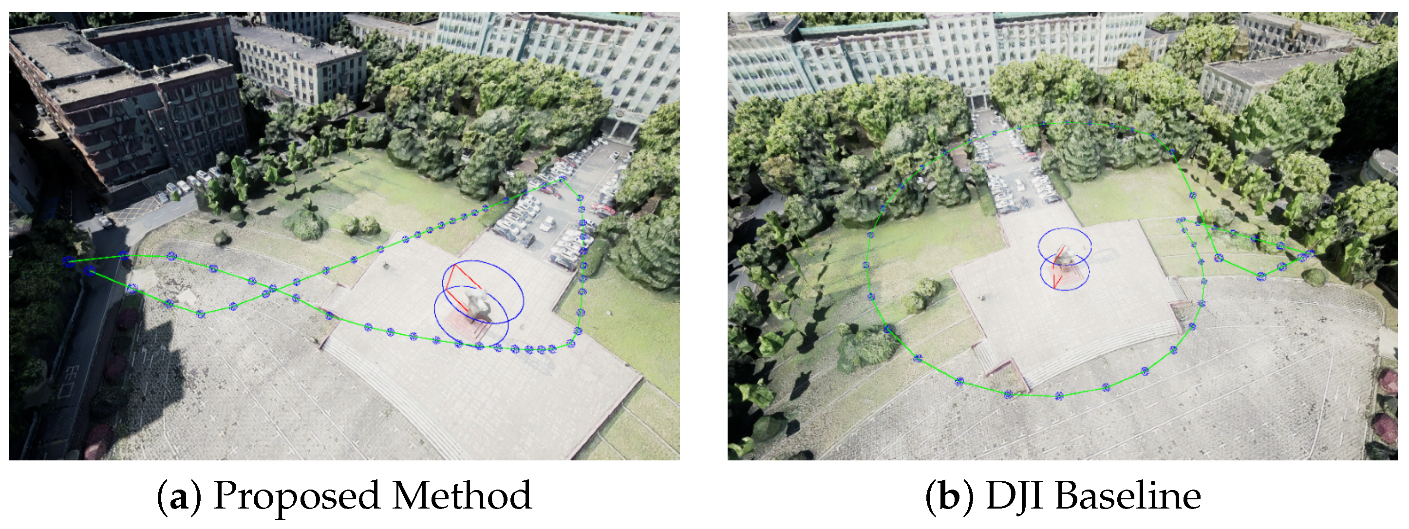
To validate the effectiveness of the proposed single-ROI trajectory generation method, it was compared with the DJI automatic mission planning approach. The DJI baseline typically generates circular orbit trajectories with a fixed radius and altitude while uniformly sampling viewpoints along the path. In contrast, the proposed method integrates spiral trajectory sampling with aesthetic viewpoint optimization, enabling the UAV to select viewpoints that better satisfy cinematographic composition principles.
As a practical commercial UAV cinematography system, the DJI waypoint planning strategy serves as a representative baseline for semi-automatic UAV cinematography planning. Although it does not represent the latest learning-based or optimization-heavy UAV cinematography planners, it provides a widely used industrial reference for evaluating planning autonomy, viewpoint consistency, visual continuity, and manual configuration complexity in practical UAV filming applications. A direct comparison with recent RL-based or end-to-end UAV cinematography planners remains challenging because many such methods are highly environment-specific and rely on different simulation platforms, control assumptions, reward formulations, and evaluation protocols, which makes fair reproduction and standardized benchmarking difficult.
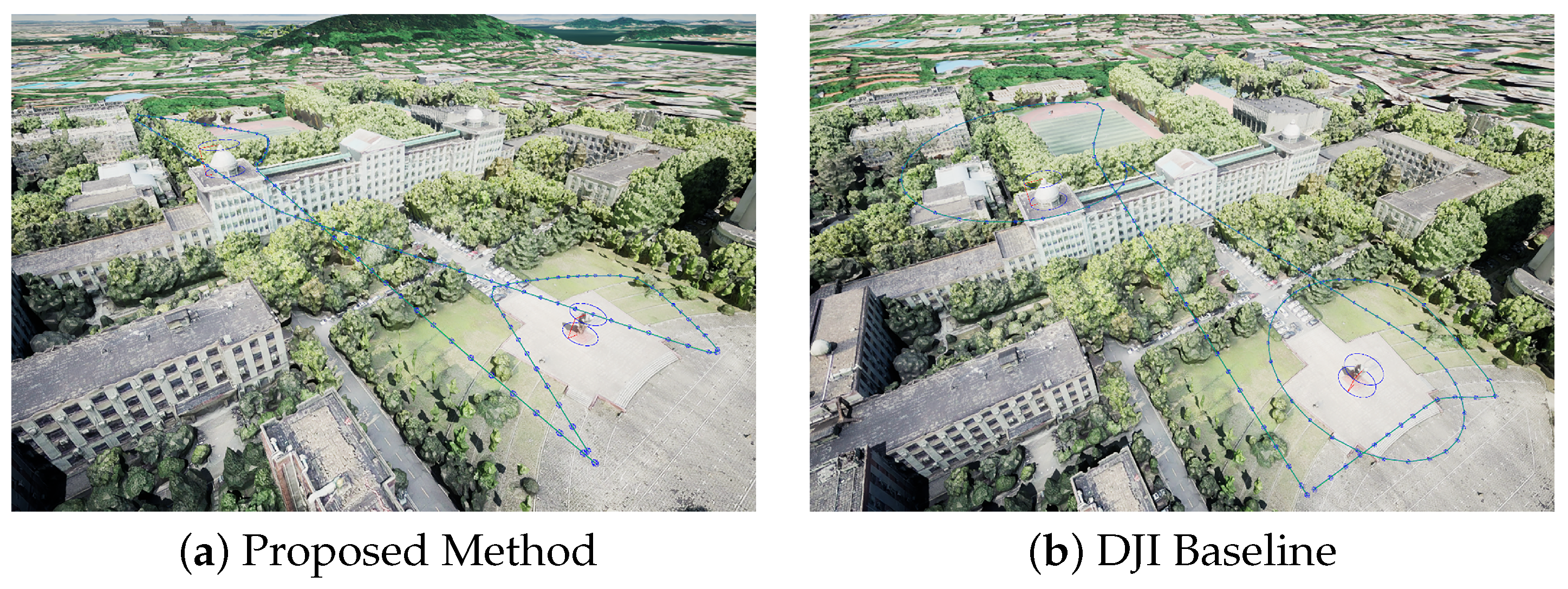
Experiments were conducted in the Wuhan University campus environment. Figure 6 illustrates the trajectories generated by the two methods. The proposed approach produces smoother orbital motion around the target and maintains more consistent subject composition during the flight.
From a quantitative perspective, the proposed method achieves an average aesthetic score of 4.774, compared with 4.510 obtained by the DJI baseline, representing an improvement of approximately 0.264 (about 5.8%). Furthermore, the minimum aesthetic score of the proposed method is 4.022, which is higher than the baseline value of 3.880. This indicates that the proposed method provides more consistent viewpoint quality across different viewing angles.
Overall, the results demonstrate that the proposed local trajectory generation method can produce smoother and more visually appealing UAV cinematography trajectories while maintaining flight feasibility. Compared with conventional automatic mission planning methods, the proposed approach shows clear advantages in viewpoint selection, composition optimization, and trajectory consistency.

4.3. Goal-Biased BiRRT* Transition Trajectory Evaluation

To evaluate the effectiveness of the proposed Goal-biased BiRRT* transition trajectory planner in complex environments, a series of experiments were conducted in simulated urban scenarios. The evaluation focuses on planning efficiency, trajectory quality, and robustness under obstacle-dense conditions.

4.3.1. Planner Performance Comparison

Our proposed Goal-biased BiRRT* algorithm was compared with standard BiRRT and RRT planners in a simulated urban environment containing multiple cylindrical obstacles.
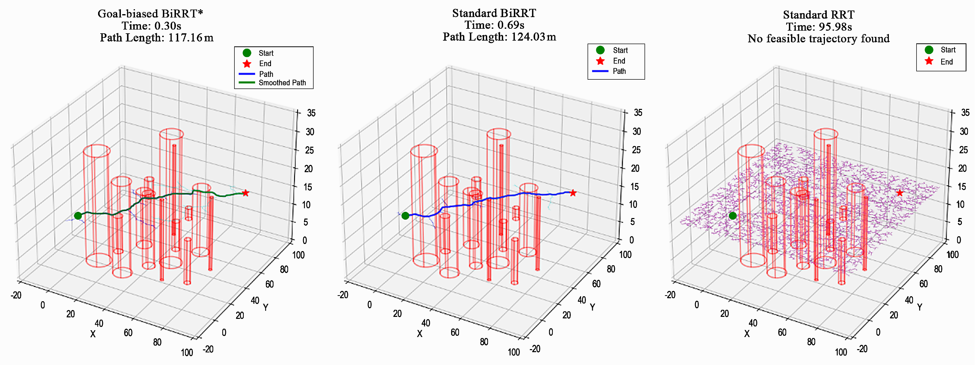
As illustrated in Figure 7, our proposed Goal-biased BiRRT* generates a relatively direct and smooth transition trajectory from the start position to the target region while maintaining safe clearance from obstacles. Compared with standard BiRRT, our proposed method produces a shorter trajectory length (117.16 m vs. 124.03 m) and requires less computation time (0.30 s vs. 0.69 s).
The standard BiRRT planner also avoids collisions successfully but produces trajectories with noticeable detours and curvature fluctuations. In contrast, the standard RRT planner exhibits highly stochastic exploration behavior and fails to generate a feasible path within the given computation time limit (95.98 s) in the illustrated scenario.
Quantitative results are summarized in Table 3, where all statistical metrics were computed over 10 independent planning trials for each method. Combined with the visual comparison in Figure 7, the results demonstrate that our proposed Goal-biased BiRRT* achieves both higher planning efficiency and more stable trajectory quality in cluttered environments.
Compared with standard RRT, our proposed Goal-biased BiRRT* is approximately two orders of magnitude faster in terms of average computation time (0.28 s vs. 26.01 s), while also reducing the average node count by more than one order of magnitude (273.9 vs. 4133.4). Compared with standard BiRRT, our proposed Goal-biased BiRRT* further improves planning efficiency while maintaining smoother and more visually coherent trajectories.
In addition, the success rate of standard RRT decreases to 90%, whereas both BiRRT-based methods maintain a 100% success rate. One representative failure case of standard RRT is illustrated in Figure 7, where the planner fails to generate a feasible path within the limited computation time. These results indicate that our proposed Goal-biased BiRRT* provides more robust and computationally efficient trajectory generation under obstacle-dense conditions.
These results demonstrate that our proposed Goal-biased BiRRT* algorithm provides an efficient and reliable foundation for global trajectory connection across multiple ROIs.

4.3.2. Obstacle Avoidance and Safety Evaluation

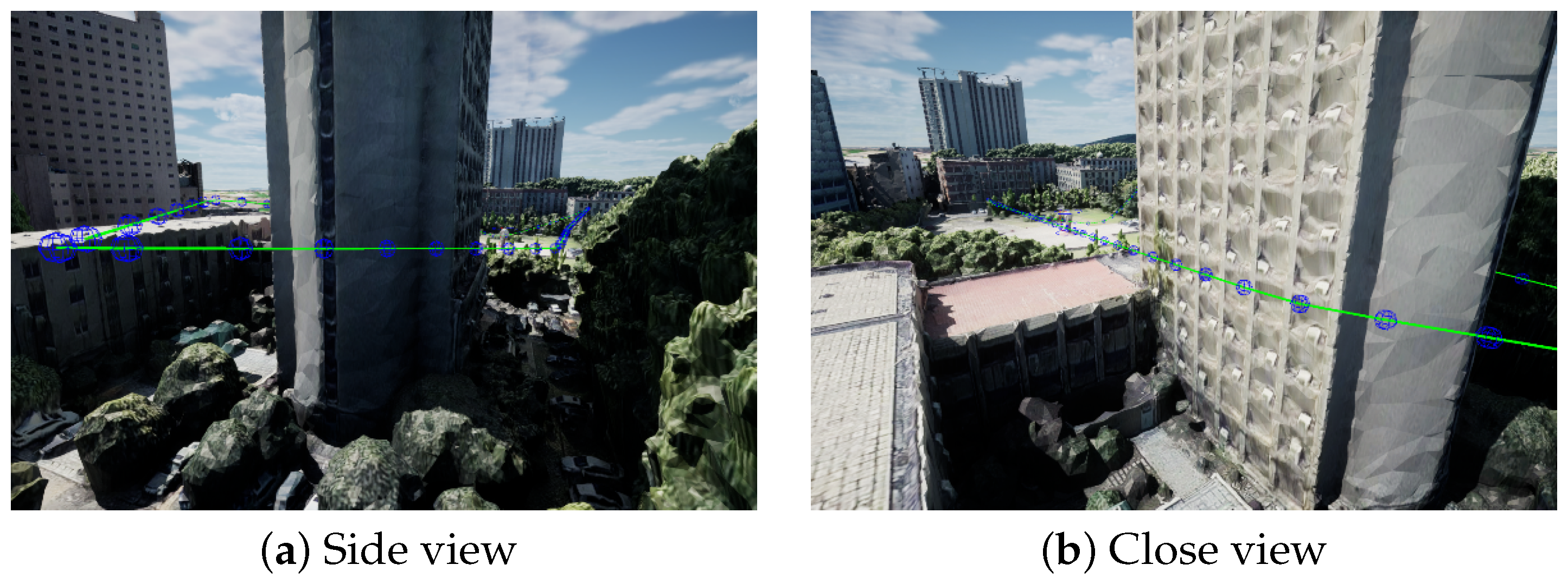
To further evaluate the feasibility and safety of the proposed framework in complex three-dimensional environments, obstacle avoidance experiments were conducted in a virtual campus environment of Wuhan University containing multiple high-rise buildings and constrained urban structures.
As shown in Figure 8, the UAV must plan a trajectory through narrow corridors formed by tall buildings. Experimental results demonstrate that the proposed method successfully generates a collision-free trajectory that passes through the constrained space while maintaining a reasonable path length.
Throughout the planning process, the generated trajectory maintains stable clearance from surrounding obstacles and exhibits smooth and continuous motion without unnecessary detours or abrupt turns. These results indicate that the proposed Goal-biased BiRRT* planner remains robust and reliable even under highly constrained spatial conditions.
Analysis of the generated trajectories shows that the minimum distance between trajectory points and obstacles exceeds 4 m across all experiments, and no violations below the safety thresholds of 2 m or 3 m were observed. This confirms that the proposed method ensures safe navigation in complex urban environments.

4.4. Global Multi-ROI Trajectory Evaluation

To further evaluate the effectiveness of the proposed global multi-ROI trajectory generation framework, experiments were conducted in a simulated urban campus environment containing multiple regions of interest.
The proposed framework integrates Goal-biased BiRRT*-based inter-ROI transition planning, ROI visiting order optimization, and multi-segment trajectory smoothing to construct a continuous global flight path with improved visual coherence.
For comparison, the DJI automatic mission planning mode was selected as the baseline method. This baseline typically generates independent circular trajectories for each ROI and connects them in a predefined visiting order without considering cross-region transition optimization or aesthetic consistency. As a result, abrupt viewpoint changes and visually discontinuous transitions may occur in multi-ROI scenarios.
Figure 9 illustrates the global trajectories generated by the two methods. The proposed framework produces smoother inter-ROI transitions and maintains more consistent visual composition throughout the entire flight path.
From a quantitative perspective, the DJI baseline achieves an average aesthetic score of 4.981, with a minimum score of 3.869 and a standard deviation of 0.493. In contrast, the proposed method improves the average score to 5.254 (approximately a 5.5% increase), raises the minimum score to 4.268, and reduces the standard deviation to 0.433. These results indicate that the proposed approach improves global composition consistency and reduces aesthetic quality fluctuations during cross-region transitions.
Overall, the proposed framework enhances trajectory smoothness, global visual coherence, and aesthetic quality in multi-ROI aerial cinematography tasks.

4.5. Computational Efficiency Analysis

To evaluate the computational overhead of the proposed framework, the complete planning pipeline was analyzed across three representative scenarios: Wuhan University campus, Central Park, and Chibi. Each scenario contains three ROIs, and the full planning process was executed ten times to obtain average runtime statistics.
Corresponding to the three-stage hierarchical framework illustrated in Figure 1, the overall computational pipeline mainly consists of the following three planning stages:
  • Local trajectory generation for individual ROIs;
  • Inter-ROI transition path search and cost evaluation;
  • STSP-based global visit order optimization.
The average computation time of each stage under different scenarios is summarized in Table 4. This stage-wise analysis further reflects the computational characteristics of the coordinated hierarchical framework shown in Figure 1.
Overall, even in environments with dense obstacles and complex spatial structures (e.g., the Central Park scenario), the end-to-end global route generation time for three ROIs remains within 25 min. This runtime satisfies the efficiency requirements of practical UAV cinematography planning tasks.
From the computational breakdown, inter-ROI transition path search and cost evaluation and local ROI trajectory generation are the most time-consuming components. Transition planning based on the Goal-biased BiRRT* algorithm requires extensive three-dimensional sampling and collision checking, resulting in computation times up to 946 s in cluttered environments. Local trajectory generation also introduces noticeable overhead due to repeated aesthetic model inference and viewpoint optimization for each ROI.
In contrast, the STSP-based global visit order optimization (Stage III in Figure 1) requires only negligible computation time and therefore has little impact on the overall runtime, indicating that the primary computational overhead of the proposed framework mainly originates from local trajectory generation and inter-ROI transition planning.
Overall, despite the computational cost of transition planning in complex environments, the proposed framework remains computationally feasible for multi-ROI aerial cinematography planning.
Although the current experiments demonstrate the effectiveness and computational feasibility of the proposed framework in representative multi-ROI UAV cinematography scenarios, the benchmarking scope is still limited. In particular, the comparison mainly focuses on a practical commercial waypoint-based baseline rather than a broad set of recent learning-based, optimization-based, or multi-objective UAV cinematography planning methods. This is partly because many existing UAV cinematography planners differ significantly in scene representation, control assumptions, simulation environments, reward formulations, and evaluation protocols, which makes fair reproduction and standardized benchmarking difficult. Future work will further investigate broader comparative evaluations against recent UAV cinematography planning frameworks under more unified benchmark settings, as well as larger-scale multi-ROI scenarios to further evaluate robustness and scalability.
From a deployment perspective, the current framework is mainly designed for offline or semi-offline UAV cinematography planning in relatively static environments rather than fully real-time autonomous operation. The primary computational bottlenecks originate from repeated three-dimensional collision checking during inter-ROI transition planning and iterative aesthetic viewpoint evaluation during local trajectory optimization.
To further improve practical applicability in time-sensitive or dynamic environments, several acceleration strategies can be considered in future work. For example, parallel trajectory sampling and collision checking may improve planning efficiency, while lightweight aesthetic evaluation networks and model compression techniques could reduce inference overhead. In addition, online local replanning strategies and incremental trajectory update mechanisms may further improve adaptability to moving obstacles and dynamic scene changes.

5. Conclusions

This paper addresses the problem of generating continuous UAV cinematography trajectories across multiple ROIs while explicitly considering aesthetic composition constraints. To tackle this challenge, a unified aesthetics-aware planning framework for multi-ROI aerial cinematography is proposed. At the local level, a lightweight aesthetic evaluation model guides viewpoint selection and composition optimization for single-ROI trajectory generation. At the global level, a Goal-biased BiRRT* planner is combined with a STSP formulation to determine efficient transition paths and optimal visiting sequences among multiple ROIs. Through coordinated optimization across local and global planning stages, the proposed framework jointly considers flight feasibility, visual composition quality, trajectory continuity, and multi-ROI filming coherence within a unified planning pipeline. The primary novelty of this work lies in the unified hierarchical coordination of aesthetics-aware viewpoint evaluation, local trajectory generation, inter-ROI transition planning, and global route organization for autonomous UAV cinematography, rather than in proposing entirely new low-level optimization algorithms.
Experimental results demonstrate that the proposed framework outperforms conventional circular-orbit and uniform-sampling planning strategies in terms of planning efficiency, trajectory smoothness, obstacle avoidance safety, and overall visual quality. By integrating learning-based aesthetic evaluation, spatial trajectory planning, and global route organization within a coordinated hierarchical planning architecture, the proposed method is able to generate more coherent and visually appealing UAV cinematography trajectories while improving planning autonomy and reducing manual configuration requirements. The proposed framework therefore provides an effective solution for intelligent and aesthetics-aware autonomous aerial cinematography systems in complex environments.
Despite the promising results, several limitations remain. First, the current aesthetic evaluation model is trained primarily on static images and therefore cannot fully capture temporal coherence and shot rhythm in aerial video sequences. Moreover, the aesthetic evaluation framework currently relies mainly on general-purpose photographic and artistic datasets rather than aerial-specific cinematography datasets, which may introduce domain bias in certain UAV filming scenarios.
Second, the system still has limited adaptability to dynamic environments, and further improvements are required to handle moving obstacles such as pedestrians and vehicles. Meanwhile, the computational cost of global planning may increase with scenario scale and the number of ROIs, which poses challenges for real-time deployment on lightweight embedded platforms. Furthermore, the current experimental comparison is mainly conducted against a practical commercial waypoint-based baseline, and broader benchmarking against recent learning-based, optimization-based, and multi-objective UAV cinematography planning frameworks under standardized evaluation protocols remains an important direction for future work.
Future work will focus on video-level aesthetic modeling, online trajectory re-planning in dynamic environments, computational acceleration strategies, and richer scene representation mechanisms to further enhance the autonomy, scalability, and practical applicability of UAV cinematography systems. In particular, parallel computation strategies, lightweight aesthetic evaluation models, and online local replanning mechanisms will be further investigated to improve real-time deployment capability in dynamic UAV cinematography environments. These directions may further improve the practical deployment capability and real-time adaptability of unified autonomous UAV cinematography systems.

Author Contributions

Methodology, Z.H. and Y.L.; software, Z.H. and Y.L.; validation, Z.H.; writing—original draft preparation, Z.H.; writing—review and editing, Z.H. and Z.J.; visualization, Z.H.; supervision, Z.J.; All authors have read and agreed to the published version of the manuscript.

Funding

This research was supported by the Hubei Provincial Science and Technology Plan Project “Research on Unmanned Monitoring Technology and Equipment for Bridge Construction Safety Based on Digital Twin” under Grant No. 2025BAB050.

Data Availability Statement

The data presented in this study are available on request from the corresponding author.

Conflicts of Interest

The authors declare no conflicts of interest.

Abbreviations

The following abbreviations are used in this manuscript:
A.-M. Coord.Aesthetics-Motion Coordination
AVAAesthetic Visual Analysis Dataset
BAIDBehance Artistic Image Dataset
BiRRT*Bidirectional Rapidly exploring Random Tree Star
CNNConvolutional Neural Network
GAGenetic Algorithm
MAEMean Absolute Error
MPCModel Predictive Control
NIMANeural Image Assessment
RMSERoot Mean Squared Error
ROIRegion of Interest
RLReinforcement Learning
RRTRapidly exploring Random Tree
RRT*Rapidly exploring Random Tree Star
RTReal-time Feasibility
STSPSet Traveling Salesman Problem
TSPTraveling Salesman Problem
UAVUnmanned Aerial Vehicle
UE5Unreal Engine 5

References

  1. Li, Q.; Yang, X.; Lu, R.; Fan, J.; Wang, S.; Qin, Z. VisionICE: Air–Ground Integrated Intelligent Cognition Visual Enhancement System Based on a UAV. Drones 2023, 7, 268. [Google Scholar] [CrossRef]
  2. Adams, C. Dual Control: Investigating the Role of Drone (UAV) Operators in TV and Online Journalism. Media Commun. 2020, 8, 93–100. [Google Scholar] [CrossRef]
  3. Alcántara, A.; Capitán, J.; Cunha, R.; Ollero, A. Optimal Trajectory Planning for Cinematography with Multiple Unmanned Aerial Vehicles. Robot. Auton. Syst. 2021, 140, 103778. [Google Scholar] [CrossRef]
  4. Wen, Y.; Liang, D.; Wu, Y. Study on the Key Technology and Application of UAV Surveying and Mapping Data Processing. J. Phys. Conf. Ser. 2021, 1744, 022089. [Google Scholar] [CrossRef]
  5. Lambertini, A.; Mandanici, E.; Tini, M.A.; Vittuari, L. Technical Challenges for Multi-Temporal and Multi-Sensor Image Processing Surveyed by UAV for Mapping and Monitoring in Precision Agriculture. Remote Sens. 2022, 14, 4954. [Google Scholar] [CrossRef]
  6. Jovanović, D.; Milovanov, S.; Ruskovski, I.; Govedarica, M.; Sladić, D.; Radulović, A.; Pajić, V. Building Virtual 3D City Model for Smart Cities Applications: A Case Study on Campus Area of the University of Novi Sad. ISPRS Int. J. Geo-Inf. 2020, 9, 476. [Google Scholar] [CrossRef]
  7. Alawad, W.; Halima, N.B.; Aziz, L. An Unmanned Aerial Vehicle (UAV) System for Disaster and Crisis Management in Smart Cities. Electronics 2023, 12, 1051. [Google Scholar] [CrossRef]
  8. Al-Dosari, K.; Fetais, N. A New Shift in Implementing Unmanned Aerial Vehicles (UAVs) in the Safety and Security of Smart Cities: A Systematic Literature Review. Safety 2023, 9, 64. [Google Scholar] [CrossRef]
  9. Abbas, N.; Abbas, Z.; Liu, X.; Khan, S.S.; Foster, E.D.; Larkin, S. A Survey: Future Smart Cities Based on Advance Control of Unmanned Aerial Vehicles (UAVs). Appl. Sci. 2023, 13, 9881. [Google Scholar] [CrossRef]
  10. Pueyo, P.; Montijano, E.; Murillo, A.C.; Schwager, M. CineMPC: Controlling Camera Intrinsics and Extrinsics for Autonomous Cinematography. In Proceedings of the 2022 International Conference on Robotics and Automation (ICRA), Philadelphia, PA, USA, 23–27 May 2022; IEEE: New York, NY, USA, 2022; pp. 4058–4064. [Google Scholar] [CrossRef]
  11. Koch, W.; Mancuso, R.; West, R.; Bestavros, A. Reinforcement Learning for UAV Attitude Control. ACM Trans. Cyber-Phys. Syst. 2019, 3, 22. [Google Scholar] [CrossRef]
  12. Ait Saadi, A.; Soukane, A.; Meraihi, Y.; Benmessaoud Gabis, A.; Mirjalili, S.; Ramdane-Cherif, A. UAV Path Planning Using Optimization Approaches: A Survey. Arch. Comput. Methods Eng. 2022, 29, 4233–4284. [Google Scholar] [CrossRef]
  13. Ahmad Shazali, A.S.; Tahar, K.N. Virtual 3D Model of Canseleri Building via Close-Range Photogrammetry Implementation. Int. J. Build. Pathol. Adapt. 2019, 38, 217–227. [Google Scholar] [CrossRef]
  14. Zhou, H.; Ji, Z.; You, X.; Liu, Y.; Chen, L.; Zhao, K.; Lin, S.; Huang, X. Geometric Primitive-Guided UAV Path Planning for High-Quality Image-Based Reconstruction. Remote Sens. 2023, 15, 2632. [Google Scholar] [CrossRef]
  15. Hao, J.; Zhou, Y.; Zhang, G.; Lv, Q.; Wu, Q. A Review of Target Tracking Algorithm Based on UAV. In Proceedings of the 2018 IEEE International Conference on Cyborg and Bionic Systems (CBS), Shenzhen, China, 25–27 October 2018; IEEE: New York, NY, USA, 2018; pp. 328–333. [Google Scholar] [CrossRef]
  16. DJI. Introduction to Waypoint Flight Mode of DJI Fly. 2026. Available online: https://repair.dji.com/help/content?customId=01700007343&spaceId=17&re=US&lang=en (accessed on 20 January 2026).
  17. Blinn, J. Where Am I? What Am I Looking at? (Cinematography). IEEE Comput. Graph. Appl. 1988, 8, 76–81. [Google Scholar] [CrossRef]
  18. Drucker, S.M.; Zeltzer, D. Intelligent Camera Control in a Virtual Environment. In Proceedings of the Graphics Interface ’94—GI ’94, Banff, AB, Canada, 18–20 May 1994; Morgan Kaufmann Publishers Inc.: San Mateo, CA, USA, 1994; pp. 190–199. [Google Scholar]
  19. Gleicher, M.; Witkin, A. Through-the-Lens Camera Control. In Proceedings of the 19th Annual Conference on Computer Graphics and Interactive Techniques, Chicago, IL, USA, 26–31 July 1992; ACM: New York, NY, USA, 1992; pp. 331–340. [Google Scholar] [CrossRef]
  20. Datta, R.; Joshi, D.; Li, J.; Wang, J.Z. Studying Aesthetics in Photographic Images Using a Computational Approach. In Computer Vision–ECCV 2006; Hutchison, D., Kanade, T., Kittler, J., Kleinberg, J.M., Mattern, F., Mitchell, J.C., Naor, M., Nierstrasz, O., Pandu Rangan, C., Steffen, B., et al., Eds.; Springer: Berlin/Heidelberg, Germany, 2006; Volume 3953, pp. 288–301. [Google Scholar] [CrossRef]
  21. Mai, L.; Le, H.; Niu, Y.; Liu, F. Rule of Thirds Detection from Photograph. In Proceedings of the 2011 IEEE International Symposium on Multimedia, Dana Point, CA, USA, 5–7 December 2011; IEEE: New York, NY, USA, 2011; pp. 91–96. [Google Scholar] [CrossRef]
  22. Arijon, D. Grammar of the Film Language; Silman-James Press: Los Angeles, CA, USA; Samuel French Trade: Hollywood, CA, USA, 1991. [Google Scholar]
  23. Bowen, C.J. Grammar of the Shot; Focal Press: Burlington, MA, USA, 2013. [Google Scholar]
  24. He, L.w.; Cohen, M.F.; Salesin, D.H. The Virtual Cinematographer: A Paradigm for Automatic Real-Time Camera Control and Directing. In Seminal Graphics Papers: Pushing the Boundaries, 1st ed.; Whitton, M.C., Ed.; ACM: New York, NY, USA, 2023; Volume 2, pp. 707–714. [Google Scholar] [CrossRef]
  25. Gebhardt, C.; Stevšić, S.; Hilliges, O. Optimizing for Aesthetically Pleasing Quadrotor Camera Motion. ACM Trans. Graph. 2018, 37, 90. [Google Scholar] [CrossRef]
  26. Vázquez, P.P.; Feixas, M.; Sbert, M.; Heidrich, W. Viewpoint Selection Using Viewpoint Entropy. In Proceedings of the Vision Modeling and Visualization Conference 2001—VMV ’01, Stuttgart, Germany, 11–23 November 2001; Aka GmbH: Berlin, Germany, 2001; pp. 273–280. [Google Scholar]
  27. Xie, K.; Yang, H.; Huang, S.; Lischinski, D.; Christie, M.; Xu, K.; Gong, M.; Cohen-Or, D.; Huang, H. Creating and Chaining Camera Moves for Quadrotor Videography. ACM Trans. Graph. 2018, 37, 88. [Google Scholar] [CrossRef]
  28. Bonatti, R.; Wang, W.; Ho, C.; Ahuja, A.; Gschwindt, M.; Camci, E.; Kayacan, E.; Choudhury, S.; Scherer, S. Autonomous Aerial Cinematography in Unstructured Environments with Learned Artistic Decision-making. J. Field Robot. 2020, 37, 606–641. [Google Scholar] [CrossRef]
  29. Joubert, N.; Roberts, M.; Truong, A.; Berthouzoz, F.; Hanrahan, P. An Interactive Tool for Designing Quadrotor Camera Shots. ACM Trans. Graph. 2015, 34, 238. [Google Scholar] [CrossRef]
  30. Joubert, N.; E, J.L.; Goldman, D.B.; Berthouzoz, F.; Roberts, M.; Landay, J.A.; Hanrahan, P. Towards a Drone Cinematographer: Guiding Quadrotor Cameras Using Visual Composition Principles. arXiv 2016, arXiv:1610.01691. [Google Scholar] [CrossRef]
  31. Serin, E.; Hasan Adali, S.; Balcisoy, S. Automatic Path Generation for Terrain Navigation. Comput. Graph. 2012, 36, 1013–1024. [Google Scholar] [CrossRef]
  32. Sokolov, D.; Plemenos, D. Virtual World Explorations by Using Topological and Semantic Knowledge. Vis. Comput. 2008, 24, 173–185. [Google Scholar] [CrossRef]
  33. Lino, C.; Christie, M.; Lamarche, F.; Schofield, G.; Olivier, P. A Real-Time Cinematography System for Interactive 3D Environments. In Proceedings of the SCA’10: 2010 ACM SIGGRAPH/Eurographics Symposium on Computer Animation, Madrid, Spain, 2–4 July 2010. [Google Scholar] [CrossRef]
  34. Epic Games. Unreal Engine 5.7 Documentation. 2026. Available online: https://dev.epicgames.com/documentation/en-us/unreal-engine/unreal-engine-5-7-documentation (accessed on 20 January 2026).
  35. Microsoft. AirSim Simulator. 2026. Available online: https://microsoft.github.io/AirSim/ (accessed on 20 January 2026).
  36. Zhao, L.; Shang, M.; Gao, F.; Li, R.; Huang, F.; Yu, J. Representation Learning of Image Composition for Aesthetic Prediction. Comput. Vis. Image Underst. 2020, 199, 103024. [Google Scholar] [CrossRef]
  37. Sandler, M.; Howard, A.; Zhu, M.; Zhmoginov, A.; Chen, L.C. MobileNetV2: Inverted Residuals and Linear Bottlenecks. arXiv 2018, arXiv:1801.04381. [Google Scholar] [CrossRef]
  38. Howard, A.G.; Zhu, M.; Chen, B.; Kalenichenko, D.; Wang, W.; Weyand, T.; Andreetto, M.; Adam, H. MobileNets: Efficient Convolutional Neural Networks for Mobile Vision Applications. arXiv 2017, arXiv:1704.04861. [Google Scholar] [CrossRef]
  39. Talebi, H.; Milanfar, P. NIMA: Neural Image Assessment. IEEE Trans. Image Process. 2018, 27, 3998–4011. [Google Scholar] [CrossRef] [PubMed]
  40. Murray, N.; Marchesotti, L.; Perronnin, F. AVA: A Large-Scale Database for Aesthetic Visual Analysis. In Proceedings of the 2012 IEEE Conference on Computer Vision and Pattern Recognition, Providence, RI, USA, 16–21 June 2012; IEEE: New York, NY, USA, 2012; pp. 2408–2415. [Google Scholar] [CrossRef]
  41. Yi, R.; Tian, H.; Gu, Z.; Lai, Y.K.; Rosin, P.L. Towards Artistic Image Aesthetics Assessment: A Large-scale Dataset and a New Method. In Proceedings of the 2023 IEEE/CVF Conference on Computer Vision and Pattern Recognition (CVPR), Vancouver, BC, Canada, 17–24 June 2023; IEEE: New York, NY, USA, 2023; pp. 22388–22397. [Google Scholar] [CrossRef]
  42. Kuffner, J.; LaValle, S. RRT-connect: An Efficient Approach to Single-Query Path Planning. In Proceedings of the 2000 ICRA. Millennium Conference. IEEE International Conference on Robotics and Automation. Symposia Proceedings (Cat. No.00CH37065), San Francisco, CA, USA, 24–28 April 2000; IEEE: New York, NY, USA, 2000; Volume 2, pp. 995–1001. [Google Scholar] [CrossRef]
Figure 1. Three-stage pipeline of the proposed aesthetics-aware multi-ROI UAV cinematography planning framework.
Drones 10 00380 g001
Figure 2. Cylindrical modeling of the ROI in the reconstructed Wuhan University campus environment, where ( x c , y c ) denotes the ground center coordinate, r c denotes the cylinder radius, and h denotes the ROI height.
Drones 10 00380 g002
Figure 3. Illustration of the initial spiral sampling trajectory around the cylindrical ROI in the reconstructed Wuhan University campus environment. The green markers denote sampled UAV positions distributed along the multi-layer spiral ascent path, and the associated numbers indicate the visiting order of the sampled viewpoints along the trajectory.
Drones 10 00380 g003
Figure 4. Candidate composition anchors defined on the image plane according to the rule-of-thirds principle for viewpoints generated in the reconstructed Wuhan University campus environment. The center point and four intersection points serve as candidate framing targets for camera orientation optimization.
Drones 10 00380 g004
Figure 5. Sensitivity analysis of the aesthetic evaluation model under viewpoint variations. (a) Predicted aesthetic scores for different camera orientations at the same spatial location. (b) Predicted aesthetic scores at different UAV flight altitudes while keeping the horizontal position fixed.
Drones 10 00380 g005
Figure 6. Comparison of local trajectory generation methods in a single ROI scenario. The proposed method produces smoother spiral trajectories and more consistent viewpoints compared with the DJI automatic mission planning baseline. The colored curves denote UAV flight trajectories, while the circular markers indicate sampled viewpoints along the trajectory.
Drones 10 00380 g006
Figure 7. Comparison of transition trajectory planning results in a simulated urban environment with cylindrical obstacles. The red cylinders denote obstacle regions, while the purple trajectories indicate infeasible random exploration paths generated by the standard RRT method.
Drones 10 00380 g007
Figure 8. Obstacle avoidance results in a high-rise urban environment with narrow corridors. The proposed planner generates collision-free trajectories in highly constrained spaces. The colored curves denote UAV flight trajectories, while the circular markers indicate sampled viewpoints along the trajectory.
Drones 10 00380 g008
Figure 9. Comparison of global multi-ROI trajectory generation methods. The proposed framework produces smoother inter-region transitions and more consistent visual composition than the DJI automatic mission planning baseline. The colored curves denote UAV flight trajectories, while the circular markers indicate sampled viewpoints along the trajectory.
Drones 10 00380 g009
Table 1. Comparison of representative UAV cinematography planning approaches. × indicates unsupported functionality, ✓ indicates supported functionality, and “Partial” indicates partially supported functionality.
MethodFeas.A.-M.M-ROIV-Cont.UnifiedAutonomyRT
Geometric camera control×××Partial×Low
Rule-based aesthetic framing×××Partial×Medium
Vision-based viewpoint evaluation×××Partial×MediumPartial
Navigation-oriented path planning×Partial××Medium
Optimization-based cinematography planningPartialPartialPartial×Medium×
Commercial UAV systems×PartialPartial×Medium
Proposed Framework HighPartial
Table 2. Quantitative comparison between the teacher model and the proposed lightweight student model in terms of model size, inference efficiency, and prediction accuracy.
MetricTeacher ModelStudent Model
Model Size (MB)17.381.18
Average Inference Time (ms)10.113.19
Pearson Correlation Coefficient0.9461 ( p = 0.0000 )
Spearman Correlation Coefficient0.9030 ( p = 0.0003 )
Mean Absolute Error (MAE)0.2786
Root Mean Squared Error (RMSE)0.2952
Table 3. Quantitative comparison of planning performance for Goal-biased BiRRT*, standard BiRRT, and standard RRT.
MetricGoal-Biased BiRRT*Standard BiRRTStandard RRT
Average Time0.28 s0.40 s26.01 s
Time Std. Dev.0.08 s0.18 s30.07 s
Average Path Length123.99 m121.65 m126.30 m
Path Length Std. Dev.7.68 m4.95 m42.49 m
Success Rate100%100%90%
Average Node Count273.9357.64133.4
Node Count Std. Dev.58.49106.883360.22
Table 4. Average computational time of each planning stage under different test scenarios.
ScenarioComputation StageTime (s)
Wuhan UniversityLocal ROI Trajectory Generation379.69
Inter-ROI Transition Search and Cost Evaluation370.71
STSP Optimization0.087
Central ParkLocal ROI Trajectory Generation369.14
Inter-ROI Transition Search and Cost Evaluation946.19
STSP Optimization0.086
ChibiLocal ROI Trajectory Generation265.46
Inter-ROI Transition Search and Cost Evaluation662.66
STSP Optimization0.096
Disclaimer/Publisher’s Note: The statements, opinions and data contained in all publications are solely those of the individual author(s) and contributor(s) and not of MDPI and/or the editor(s). MDPI and/or the editor(s) disclaim responsibility for any injury to people or property resulting from any ideas, methods, instructions or products referred to in the content.