Systematic Review

Identification of Pathologies in Pavements by Unmanned Aerial Vehicle (UAV): A Systematic Literature Review

1
Escuela de Construcción Civil, Pontificia Universidad Católica de Chile, Avenida Vicuña Mackenna 4860, Santiago 7820436, Chile
2
Escuela de Ingeniería Informática, Pontificia Universidad Católica de Valparaíso, Avenida Brasil 2241, Valparaíso 2362807, Chile
3
Escuela de Negocios Internacionales, Universidad de Valparaíso, Alcalde Prieto Nieto 452, Viña del Mar 2572048, Chile
*
Author to whom correspondence should be addressed.
Drones 2026, 10(2), 90; https://doi.org/10.3390/drones10020090
Submission received: 3 December 2025 / Revised: 8 January 2026 / Accepted: 20 January 2026 / Published: 28 January 2026

Highlights

What are the main findings?
  • More researches are using UAV and computer vision approaches to identify pathologies in pavements.
  • Research objectives and themes in this area are more focused on specific objects nowadays.
What are the implications of the main findings?
  • The results provide practical guidelines for future research directions such as UAV platforms and identification problems.
  • The findings suggest that more current gaps can be filled, such as diversity in pathology categories and pavement materials, to advance UAV and computer vision as an alternative to conventional inspection.

Abstract

The identification and monitoring of pavement pathologies are critical for maintaining road infrastructure and ensuring transportation safety. As traditional inspection methods are often time-consuming, labor-intensive, and prone to human error, in recent years, Unmanned Aerial Vehicles (UAVs) have emerged as a promising tool for pavement condition assessment due to their mobility, efficiency, and ability to capture high-resolution imagery and multi-sensor data. This Systematic Literature Review aims to synthesize and evaluate existing research on the use of UAV for identifying pavement pathologies, such as cracks, potholes, rutting, and surface degradation. Following the Preferred Reporting Items for Systematic Reviews and Meta-Analysis (PRISMA) methodology, publications were screened and selected across major academic databases such as Scopus and Web of Science. A total of 361 relevant articles published from 2020 to July 2025 were identified and analyzed using bibliometric overview. And a full-text synthesis and qualitative analysis was performed on a subset of 108 studies, which met the quality assessment criteria. The review categorizes the UAV systems, computer vision approaches, pathology types, and pavement materials examined in the studies. The findings indicate a growing trend in the use of UAV and computer vision techniques for pavement pathology detection, along with evolving preferences for UAV platforms, analytical approaches, and targeted pathology categories over time. This review highlights current gaps and outlines future research directions to advance UAV-based pavement pathology identification as a viable and reliable alternative to conventional inspection methods.

1. Introduction

Pavement infrastructure is a fundamental component of modern transportation networks, supporting economic development and enabling social connectivity [1]. However, its progressive deterioration remains a persistent challenge for civil engineering and transportation agencies worldwide [2]. Environmental exposure [3], increasing traffic loads [4], and material aging [5] are among the main factors contributing to pavement pathologies such as cracks, potholes, and rutting [6]. If not properly addressed, these defects can compromise road safety, degrade ride quality, and lead to costly maintenance operations or premature reconstruction [7].
Traditional pavement inspection methods, typically based on manual surveys or ground-based vehicles, are labor-intensive, time-consuming, and may expose to risks [8]. In addition, the subjective nature of visual assessments introduces inconsistencies in defect identification and in the classification of deterioration severity [9]. Recent advances in Unmanned Aerial Vehicle (UAV) systems and Computer Vision (CV) methodologies have begun to transform inspection workflows across asset monitoring and management.
UAV provide notable advantages for acquiring aerial imagery and surface data with high efficiency, extensive coverage, and minimal human intervention, even in hard-to-access locations [10]. Equipped with high-resolution cameras and additional sensors, they can capture detailed pavement imagery without disrupting traffic flow [11]. When integrated with CV techniques, these data can be automatically processed to quantify pavement pathologies, offering a more objective alternative to traditional inspection methods [12]. The combination of UAV and CV technologies thus holds strong potential for enabling advanced and autonomous systems, which are capable of identifying and characterizing a wide spectrum of pavement defects.
A wide range of UAV platforms have been employed for infrastructure monitoring. For example, the generation of orthophotos for pavement surface defect analysis [13]; the acquisition of oblique imagery for 3D pavement modeling [14]; the use of LiDAR (Light Detection and Ranging) for surface deformation assessment [15]; and the application of thermal profiling during pavement construction [16]. In parallel, numerous studies have explored the integration of UAV and CV technologies, specifically for the identification of pavement pathologies.
A diverse set of CV-based techniques has been applied for the automatic identification of pavement defects. For example, object-detection models for classification and localization [17]; semantic segmentation approaches for pixel-level crack extraction and quantification [18]; artificial neural networks for pavement condition assessment [19]; and machine-learning clustering algorithms for severity evaluation [20]. These methods collectively illustrate the expanding methodological landscape of UAV-assisted pavement inspection.
This Systematic Literature Review (SLR) aims to synthesize the current state of research on pavement pathology identification enabled by the combined use of UAV and CV technologies. Through a systematic analysis of the existing literature, this SLR seeks to
1. Assess publication trends related to UAV-based pavement pathology detection, including leading journals, contributing countries, and temporal evolution.
2. Identify and categorize the types of pavements and pathologies examined using UAV imagery.
3. Evaluate and compare the UAV platforms and configurations adopted in prior studies.
4. Examine the specific identification problems addressed through UAV-CV approaches and summarize the methodologies employed.
5. Highlight current research gaps and outline future directions to advance UAV- and CV-based pavement pathology identification.
Through a comprehensive and critical examination of the literature, this review seeks to offer a robust reference for researchers, practitioners, and policymakers. It focuses on those interested in leveraging emerging technologies to enhance the efficiency, safety, and sustainability of pavement inspection, maintenance, and management processes.
This review advances the state of the art in several keyways. It provides updated temporal coverage from 2020 to 2025, capturing the rapid evolution of UAV-based pavement pathology research in the era of convolutional neural networks, transformer-based models, and edge computing. Unlike the prior reviews that emphasize algorithmic performance alone, this study introduces a comprehensive taxonomy that systematically categorizes UAV-based pavement inspection studies according to pavement types, UAV platforms, identification tasks, and pathology categories. In addition, a bibliometric and trend analysis is conducted to identify dominant research themes, geographic distribution, and emerging directions, thereby providing strategic insights for researchers and practitioners.
Collectively, these contributions position this review as a consolidated and forward-looking reference that not only synthesizes recent progress but also identifies open challenges and future research opportunities in UAV-based pavement pathology identification.

2. Methodology

This section describes the methodology adopted for the SLR, which was structured into five main stages:
1. Formulation of the research questions to align with the study objectives;
2. Definition of the search strategy, including databases, keywords, and search trends;
3. Establishment of inclusion and exclusion criteria based on titles, abstracts, and keywords;
4. Quality assessment of the selected studies through a relevance-based scoring system;
5. Data extraction, synthesis, and reporting of findings.
The overall process followed the Preferred Reporting Items for Systematic Reviews and Meta-Analyses (PRISMA) guidelines and checklist, as shown in the Supplementary Materials [21,22,23]. A summary of the five stages of the SLR methodology is presented in Table 1.

2.1. Research Questions

The overarching question guiding this study is as follows: How can a comprehensive perspective be established on the identification of pavement pathologies using UAV?
To address this central inquiry, two specific research questions (RQs) were formulated:
RQ1: What UAV systems and CV approaches have been applied between 2020 and 22 July 2025 for the identification of pavement pathologies?
RQ2: What types of pavement pathologies and pavement materials have been identified within the same period using UAV-based methods?
To answer RQ1, multiple analytical aspects were considered, including the annual distribution of publications, the publishing venues such as journals or conferences, and the types of UAV and CV techniques employed.
For RQ2, the scope of the studies was examined in terms of the categories of pavement pathologies addressed and the types of pavement surfaces investigated.

2.2. Search Process

The literature search was conducted using two major academic databases: Scopus and Web of Science (WoS). The time frame was restricted to publications from January 2020 to July 2025 to capture recent advances in UAV and CV applications for pavement pathology identification. The year 2020 was selected as a starting point due to the significant technological advances and increased research activity in UAV-based inspection observed after this period. For example, the increased autonomy, multi-sensor integration, real-time data processing, Beyond Visual Line-of-Sight (BVLOS) operations, and enhanced flight capabilities and endurance [24,25].
Four main search fields (SFs) were defined to guide the query formulation:
-
SF1: “identification” OR “detection” OR “inspection” OR “monitoring”.
-
SF2: “pathology” OR “damage” OR “defect” OR “deterioration” OR “distress” OR “crack”.
-
SF3: “pavement” OR “road” OR “highway”.
-
SF4: “UAV” OR “drone”.
The final search strings used in the databases were as follows:
Scopus: Article title, Abstract, Keywords (“identification” OR “detection” OR “inspection” OR “monitoring”) AND Article title, Abstract, Keywords (“pathology” OR “damage” OR “defect” OR “deterioration” OR “distress” OR “crack”) AND Article title, Abstract, Keywords (“pavement” OR “road” OR “highway”) AND Article title, Abstract, Keywords (“UAV” OR “drone”).
WoS: Topic (“identification” Or “detection” Or “inspection” Or “monitoring”) And Topic (“pathology” Or “damage” Or “defect” Or “deterioration” Or “distress” Or “crack”) And Topic (“pavement” Or “road” Or “highway”) And Topic (“UAV” Or “drone”).

2.3. Inclusion and Exclusion Criteria

Eligibility criteria were applied to the search results to ensure the relevance and quality of the selected studies. Only articles written in English were considered, as this is the predominant language in international scientific databases. Publications in other languages were excluded due to their limited presence and accessibility in global indexing systems. Publications that were inaccessible were also removed.
Duplicate records and papers not involving UAV-based analyses were excluded. Only studies that explicitly addressed the identification or monitoring of pavement pathologies using UAV were included. Literature review papers were also excluded to avoid redundancy with this study. Two reviewers independently conducted the screening process, and disagreements were resolved through discussion until consensus was achieved. This process followed the PRISMA recommendations to ensure transparency and reproducibility [22,23].

2.4. Quality Assessment

A second filtering stage evaluated the methodological quality and relevance of the selected studies through a structured scoring system. Each study was assessed using five primary questions (Q1–Q5). A “Yes” answer received one point and a “No” answer received zero point. Studies with a total score below three were excluded from further analysis. The main criteria were as follows:
-
Q1: Does the study employ UAV for data acquisition?
-
Q2: Does the study address an identification or classification problem?
-
Q3: Is the identified object a pavement pathology?
-
Q4: Are the identified pathologies located on pavements?
-
Q5: Does the study use a CV approach?
In addition, complementary sub-questions (Q1.1–Q5.4) were used to extract detailed information about UAV systems, types of pathologies identified, pavement materials, and CV algorithms implemented. These sub-questions were not used for scoring but for data extraction purposes.

2.5. Data Collection

Data were extracted from each selected article using a standardized template, which included: bibliographic information, year of publication, journal or conference, country of authors, quality score, UAV and sensor specifications, CV algorithm used, type of pathology, pavement category, and key findings. This systematic extraction enabled a consistent and comparative synthesis of UAV-CV applications for pavement pathology identification.
  • Q1: Does the study employ UAV for data acquisition?
    -
    Q1.1: Is data acquired exclusively with an RGB sensor?
    -
    Q1.2: Is a thermal sensor used for data acquisition?
    -
    Q1.3: Is any other type of sensor used for data acquisition?
    -
    Q1.4: Which camera or sensor model is employed?
    -
    Q1.5: What flight parameters are reported?
    -
    Q1.6: Are only nadir images captured, or are oblique images also used?
    -
    Q1.7: Are Ground Control Points (GCP) used for rectification?
    -
    Q1.8: What spatial accuracy metrics are reported?
    -
    Q1.9: Are any visual accuracy metrics reported?
  • Q2: Does the study address an identification or a classification problem?
    -
    Q2.1: How many elements are targeted for identification or classification?
  • Q3: Is the identified object a pavement pathology?
    -
    Q3.1: How many instances or locations are investigated?
  • Q4: Are the identified pathologies located on pavements?
    -
    Q4.1: What type of pavement is inspected?
    -
    Q4.2: Is a reference or standard sample used for comparison?
    -
    Q4.3: Is image analysis supported by a locally developed implementation or by a decision-support procedure?
  • Q5: Does the study use a CV approach?
    -
    Q5.1: Which identification or classification algorithm is used?
    -
    Q5.2: Is classification performed directly from individual images or from orthomosaics generated through photogrammetry?
    -
    Q5.3: How many images are used for the analysis?
    -
    Q5.4: Is any data augmentation technique applied?

3. Results

This section presents a descriptive and bibliometric analysis of the selected studies, followed by the results of the literature search, screening, and data collection processes. A full-text synthesis and qualitative analysis was performed on a subset of studies that met the quality assessment criteria, including quality evaluation, quality factors, and popularity factors.

3.1. General and Bigram Analysis

A descriptive bibliometric analysis was conducted using the Bibliometrix (v4.0.0) R-package and its Biblioshiny interface [26,27]. The analysis on 361 selected studies covered key descriptive indicators such as the year of publication, publication trends, countries of sources, publication types, geographical distribution, collaboration networks, and relationships among keywords.
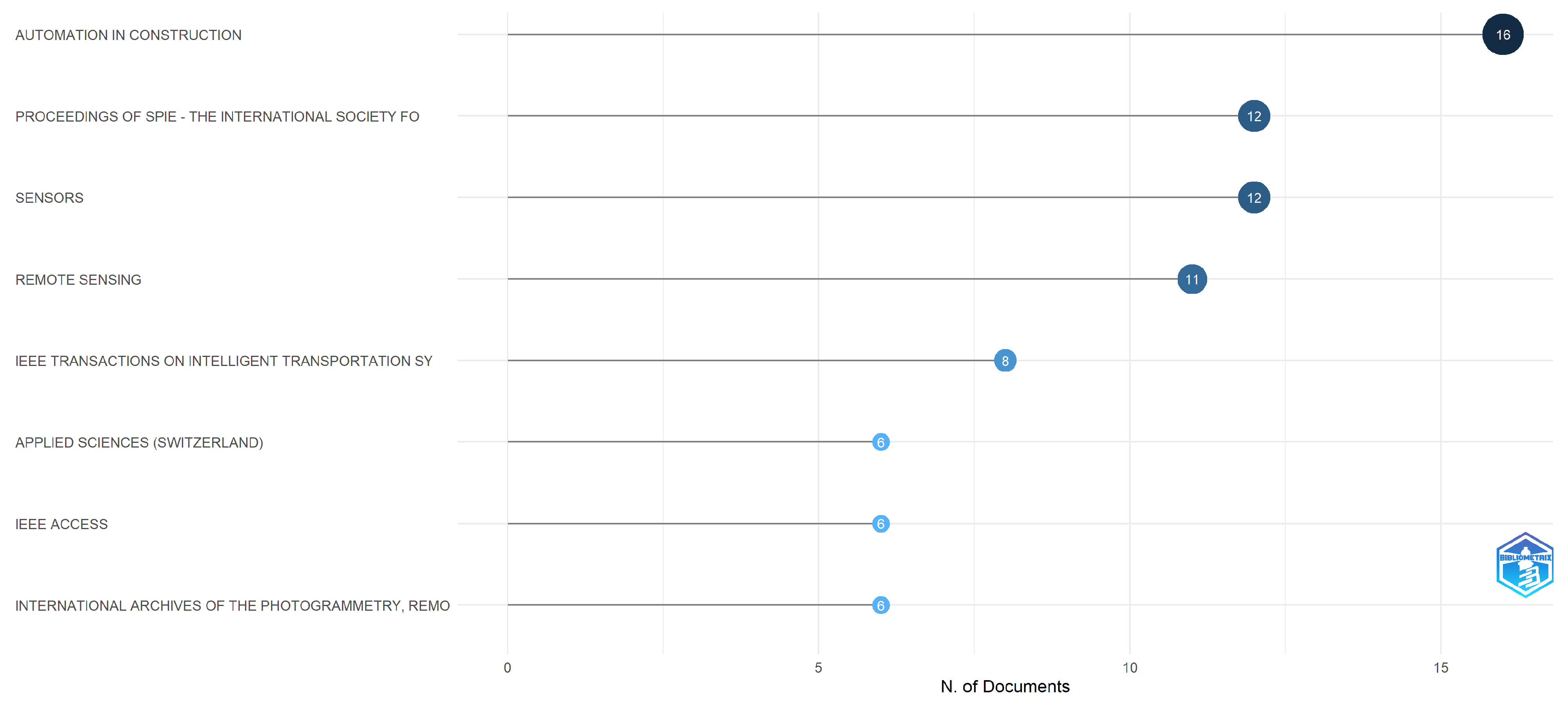
Figure 1 shows the most relevant journals and conferences publishing research on pavement pathology identification using UAV technologies. The journals Automation in Construction, Sensors, Remote Sensing, and the Proceedings of SPIE—The International Society for Optical Engineering were identified as the main publication venues. Additionally, the IEEE leads the conference proceedings in this domain, reflecting the increasing integration of computer science and electronic engineering approaches within civil engineering applications.
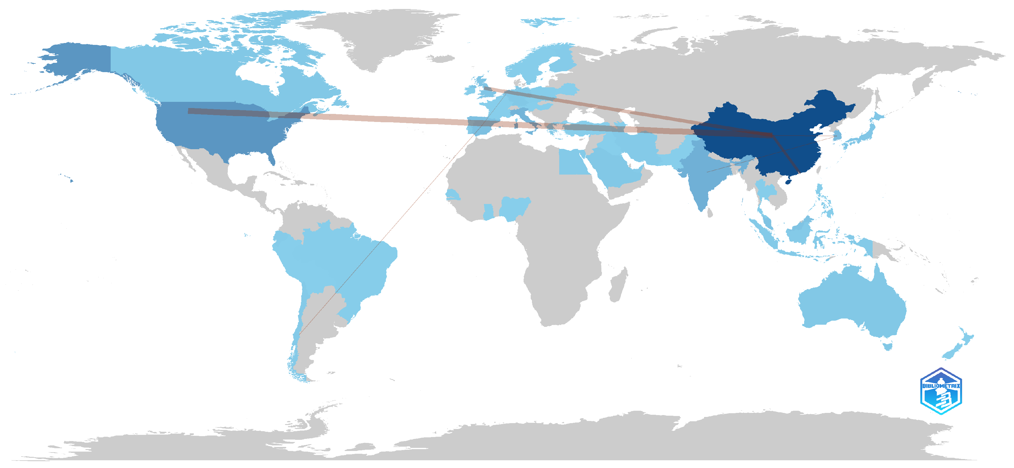
Figure 2 presents the geographical distribution of publications. China stands out with most contributions, followed by the United States and Italy. The collaboration network analysis revealed that the strongest international cooperation occurs between China and the United States, which aligns with their dominant output in this field. Furthermore, Spain exhibits the most active collaboration with Chile, with two co-authored studies.
These patterns suggest that research on UAV-based pavement pathology detection has been largely driven by countries with advanced infrastructure monitoring programs. Such efforts are further supported by strong investments in computer vision technologies.
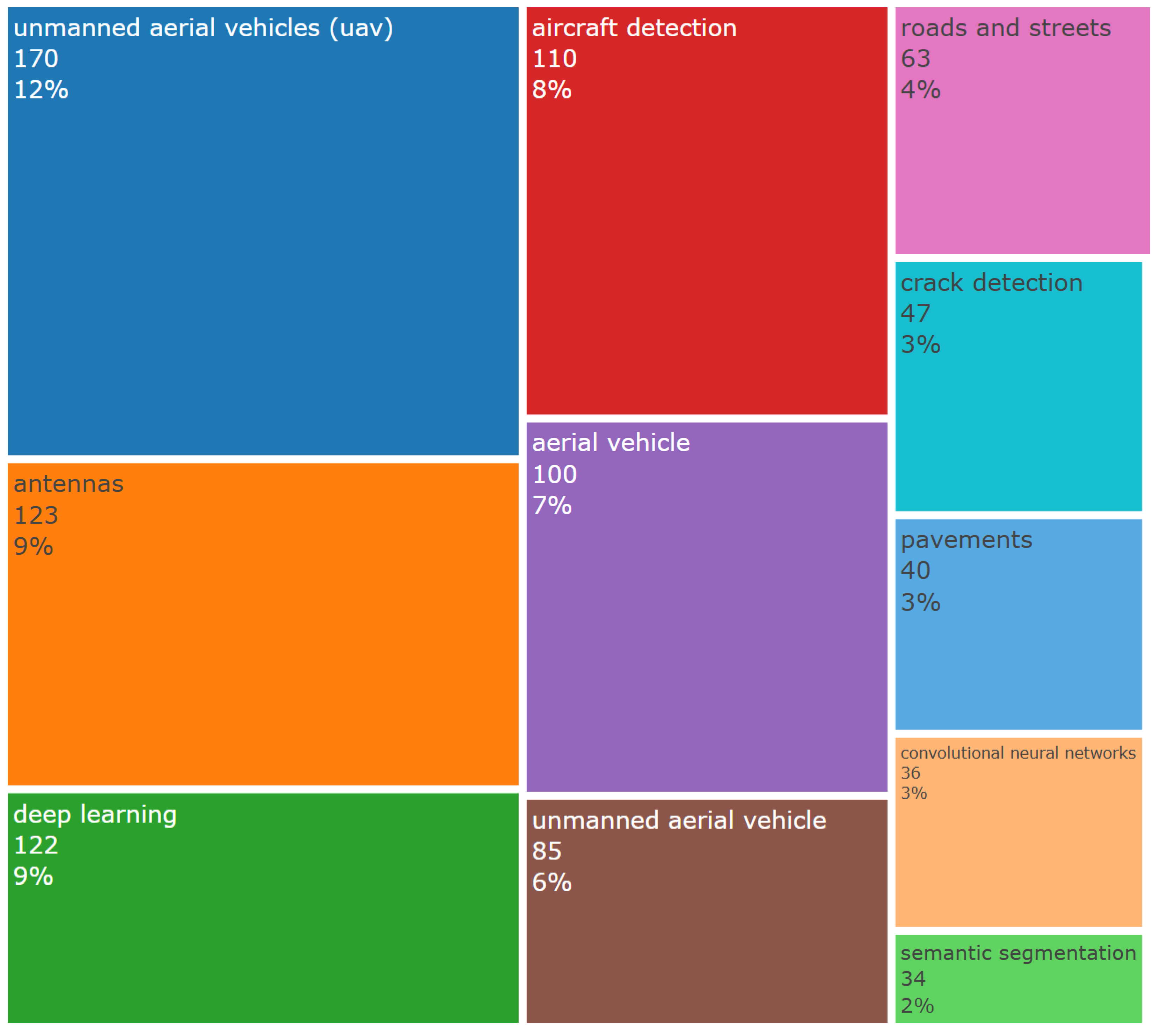
A bigram refers to a pair of consecutive words extracted from a corpus, allowing the statistical analysis of co-occurrence patterns among keywords [27]. A Treemap visualization was generated to display the most frequent bigrams related to each research topic, as shown in Figure 3. A tree map allows us to show hierarchy and proportion at the same time, where each rectangle is proportional to a variable to be studied. The results revealed that UAV was the most frequent term, strongly associated with related keywords, such as antennas, aircraft detection, aerial vehicle, drone, and remote sensing. These associations indicate a strong technological focus on aerial data acquisition, and these terms come from broader UAV literature captured by the search fields.
The second most prevalent bigram group corresponded to deep learning, linked to terms such as damage detection, crack detection, convolutional neural networks, semantic segmentation, inspection, object detection, image enhancement, and computer vision. This reflects the increasing adoption of CV-based processing methods for automated pavement assessment. Finally, bigrams related to road infrastructure, such as roads, streets, pavement distress, road cracks, and deterioration, were also prominent, representing the physical domain of application.
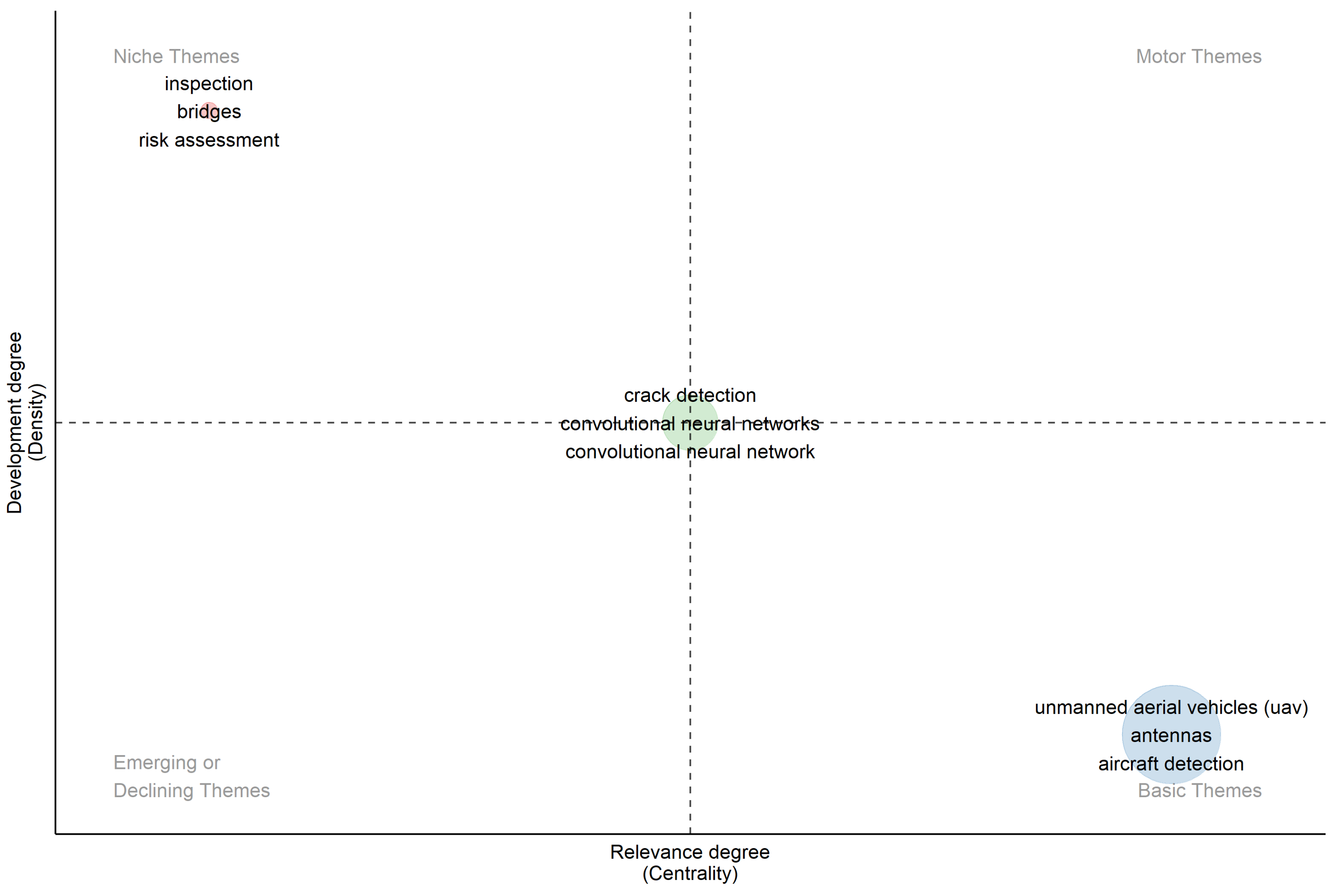
A thematic map was subsequently developed to conduct a clustering analysis of bigrams, combining the concepts of internal density and external centrality [28,29]. A thematic map is a cartographic representation designed to show the spatial distribution of a specific theme or phenomenon over a territory. As illustrated in Figure 4, three main thematic clusters were identified: UAV, inspection, and crack detection. These clusters are consistent with the thematic groups identified in the Treemap. Meanwhile, centrality indicates the relevance degree among the terms, while density shows the development degree of them.
The UAV cluster was classified as a basic theme with high centrality and low density, representing a foundational and widely connected topic that underpins most studies. Because different techniques were used for UAV flights in these literature with the highest cluster frequency. Conversely, the inspection cluster was categorized as a niche theme with high density and low centrality, indicating a specialized and methodologically focused area with limited cross-linkages. Because most techniques were used to inspect pavement pathology in these studies with the lowest cluster frequency. Meanwhile, the crack detection cluster occupied an intermediate position with balanced centrality and density, reflecting its role as the most common application domain of UAV-based inspection studies.
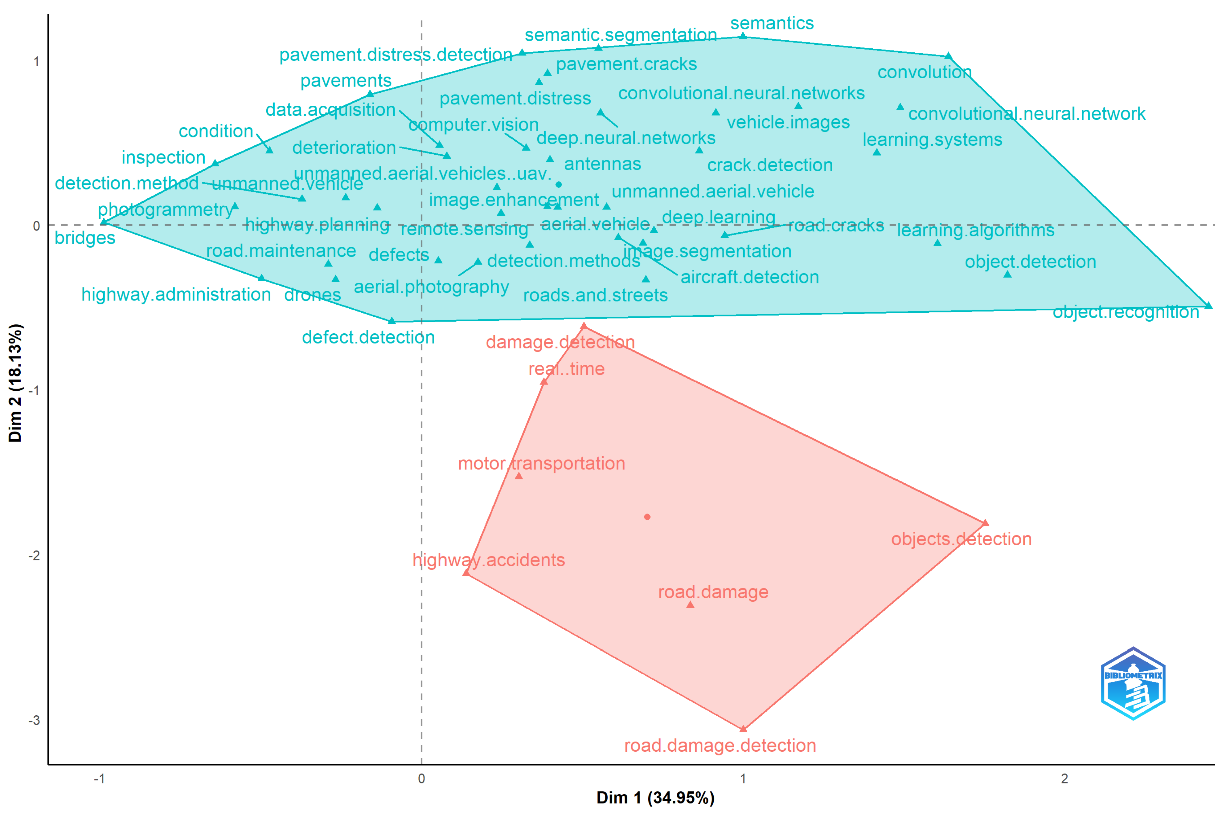
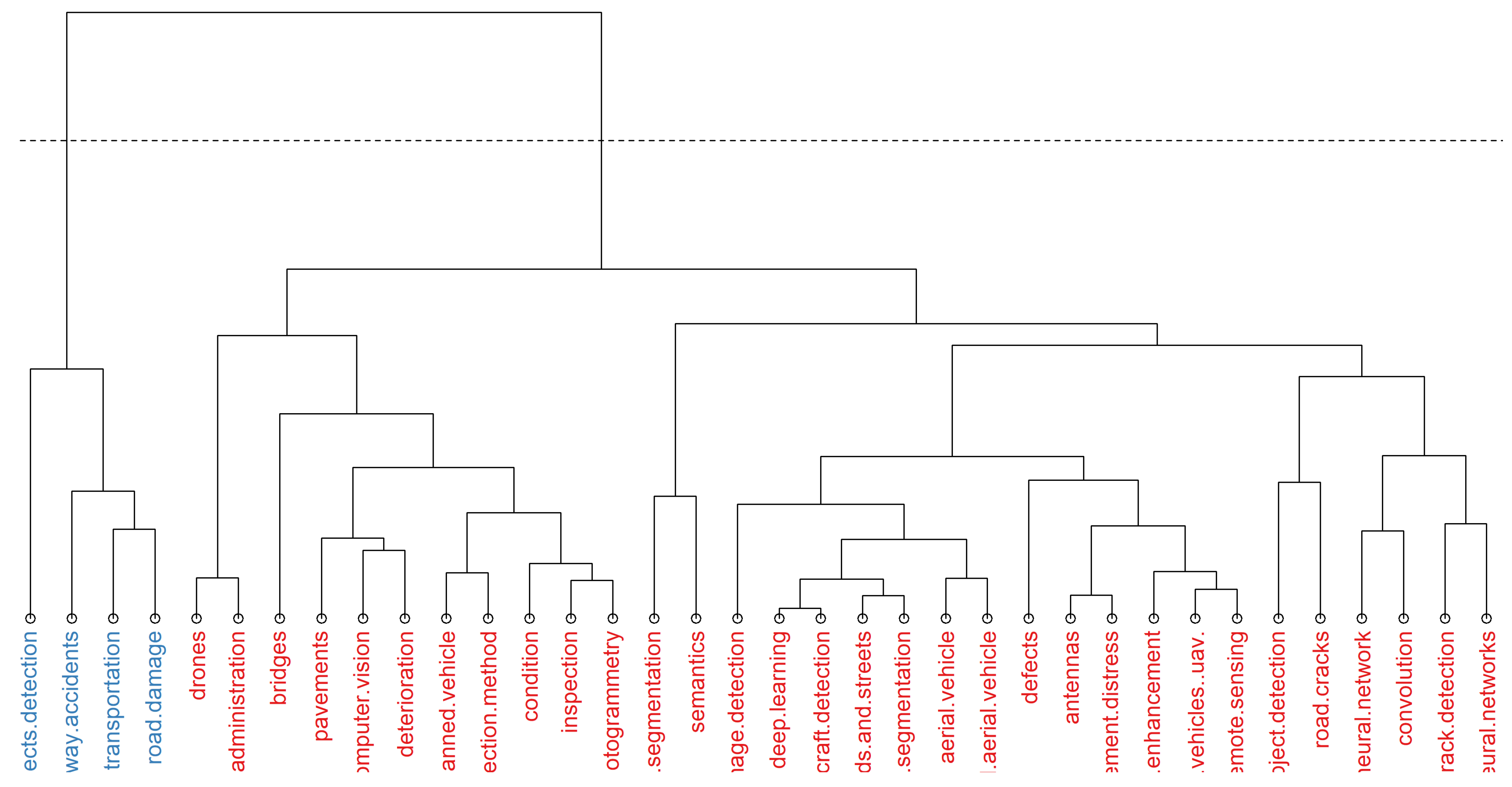
Finally, conceptual and factorial bigram analyses were performed to explore the conceptual structure of the literature using correspondence analysis and hierarchical clustering, as shown in Figure 5 and Figure 6. Two main conceptual groups were identified. The blue cluster included terms such as UAV, identification, and deep learning. These terms are primarily associated with methodological approaches and image-processing techniques, particularly object recognition and convolutional models. The red cluster contained terms such as road and damage, representing the application-oriented concepts related to infrastructure and distress detection. The connection between these two clusters highlights the strong interdependence between technological approaches and the practical objectives of pavement pathology identification.

3.2. Search Results

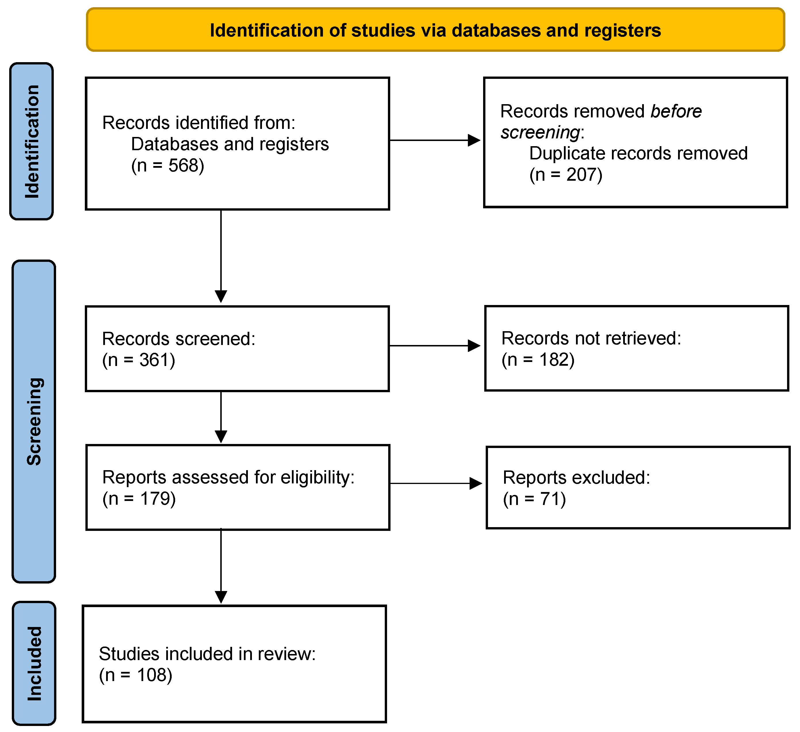
In the first round of the literature search, a total of 568 articles were retrieved from Scopus and WoS databases, as shown in Table 2 and Figure 7. 361 publications were screened based on their titles, abstracts, and keywords. During the second round, a quality assessment was conducted according to the inclusion criteria defined in Section 2.4. As a result, 179 publications were retained for full-text evaluation, as they met the established criteria. In the third round, these publications were further screened by investigators in detail to ensure the quality of the articles. Ultimately, 108 studies were included for data extraction and detailed analysis.

3.3. Quality Evaluation of Articles

The quality of the 108 selected articles was evaluated according to the criteria described in Section 2.4. The results of this assessment are summarized in Table 3 and Table 4. Each article was scored based on five evaluation questions (Q1–Q5), and inter-rater agreement between reviewers was calculated to minimize bias. The last threshold shows the score of three raters’ agreements on the quality evaluation of selected articles, where 1 represents the rater agreeing on the quality while 0 means disagreement. Studies with a sum score below three points were excluded from further analysis to resolve the disagreements. As a result, 253 publications were discarded, and only those achieving a score no less than three were retained for synthesis.

3.4. Quality Factors

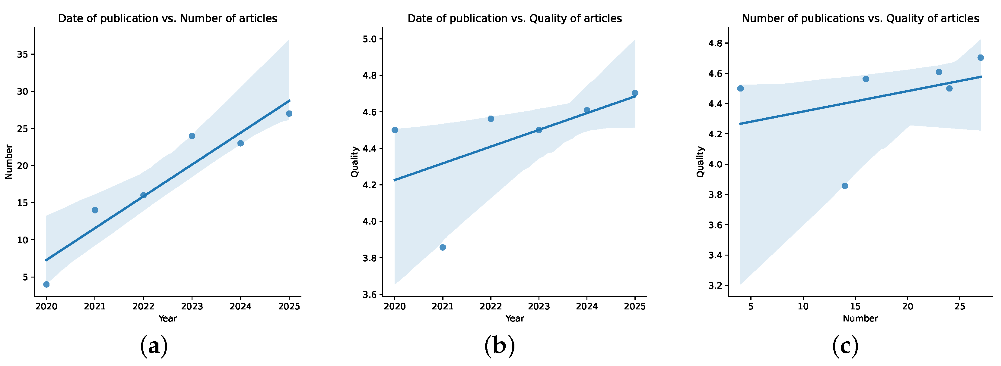
The trend between the number and quality of selected articles over time was examined to investigate potential correlations, and a statistical analysis was conducted to evaluate this trend. The average quality score for each year was calculated using Equation (1), enabling a quantitative comparison of article quality. As presented in Table 5, there is a clear increasing trend in the number of selected publications over the years. This indicates an increasing interest in automated pavement inspection due to advances in UAV sensors and growth of CV approaches. It is also noteworthy that, although only half of 2025 was considered, the number of articles already exceeded that of previous years. Therefore, it is expected that more papers will be published by the end of 2025.
Average quality score = Sum of scores Number of articles
A statistical analysis was also performed to assess the correlations between (i) the number of publications and their publication year; (ii) the quality of publications and their publication year; and (iii) the quality of publications and the number of publications, as shown in Figure 8. The results show that the number of publications has grown consistently over time. This trend is supported by a correlation coefficient of 0.948 and a p-value below 0.01, indicating a very strong and statistically significant positive relationship. Meanwhile, article quality showed a moderate positive correlation both with the publication year and with the number of publications, with correlation coefficients of 0.567 and 0.376, respectively. However, since the p-values of these two relationships were both higher than 0.2, their statistical significance was not strong.

3.5. Popularity Factors

The 108 selected articles were studied to explore the relationships between the popularity of UAV models, identification problems, pathology categories, and pavement types in relation to the year of publication. Data for these four characteristics were extracted and quantified according to their publication year to identify temporal trends and dominant research focuses.
As shown in Table 6, the most widely used UAV models for pavement pathology identification are the DJI Phantom 4 Pro and DJI Phantom 4 (DJI, Shenzhen, China), both belonging to the same series. It was observed that DJI is by far the most frequently employed UAV brand in the reviewed studies, significantly surpassing other manufacturers. Interestingly, the choice of UAV model does not appear to correlate directly with the year of publication. For instance, the DJI Phantom 4 Pro was consistently used across studies from 2021 to 2025, while the DJI Matrice 600 Pro appeared mainly in 2023–2024 and the DJI Matrice 300 in 2025. This suggests that researchers prioritize UAV functionality and experimental suitability over the release date or technological novelty of the models. Despite the technological evolution of UAVs during the investigated period, researchers tend to favor models with proven reliability and well-documented performance. They do so rather than adopting the newest or most complex platforms. Therefore, it is recommended that future studies select UAV platforms based on specific project requirements and sensor capabilities. This approach is preferable to opting for the most advanced or expensive alternatives.
Table 7 summarizes the evolution of research focus according to the type of identification problem addressed. Detection and segmentation remain the most prevalent tasks in UAV-based pavement pathology identification, while quantification and evaluation have recently gained more attention. Before 2022, segmentation dominated as the main research topic. However, from 2022 onward, detection has become the predominant focus, reflecting a shift toward real-time and application-oriented analysis. In parallel, quantification and evaluation have emerged as growing areas of interest, as they represent subsequent stages following initial detection and segmentation. These stages are crucial for assessing pavement condition and prioritizing maintenance. Consequently, future research should aim to develop methodologies that advance beyond visual recognition. These efforts should address quantification, evaluation, and repair, while continuing to enhance detection accuracy and computational efficiency for real-time applications.
As presented in Table 8, damage, distress, and cracks are the most frequently identified pavement pathologies across the reviewed studies, while potholes and landslides were also inspected in a smaller number of publications. Crack detection was the main focus prior to 2021 and continues to be the most studied pathology, given that cracks are the most common and early indicators of pavement deterioration that may evolve into more severe defects. Since 2021, however, there has been a noticeable increase in studies targeting broader categories such as damage and distress. This shift has been enabled by advancements in UAV imaging and computer vision algorithms, which are capable of detecting multiple pathology types. Therefore, future research is encouraged to extend UAV applications toward more comprehensive identification frameworks encompassing diverse pathology types beyond cracking.
Finally, Table 9 shows that flexible pavements are by far the most extensively investigated surface type, followed by soil pavements. Meanwhile, rigid, stone, and bridge pavements have received comparatively limited attention. The predominance of flexible pavements reflects their widespread use in transportation infrastructure and the suitability of UAV-based image analysis for asphalt surfaces. Nevertheless, the continued inclusion of soil pavements in recent studies indicates ongoing interest in UAV applications for rural, mining, and off-road environments, where unpaved roads remain prevalent. Future research should therefore aim to diversify UAV-based inspection methodologies to include a broader range of pavement materials and structural conditions. This approach would help ensure more comprehensive and representative outcomes for pavement management systems.
The analysis demonstrates that UAV-based pavement pathology identification research remains concentrated on a limited set of configurations, primarily crack detection in flexible pavements using commercial DJI platforms. Although this focus has contributed to significant technical progress, future investigations should strive for greater methodological diversity. This includes incorporating emerging UAV technologies, multi-modal data sources, and underexplored pavement contexts.

4. Discussion

This section discusses the findings of the SLR in response to the formulated research questions.

4.1. What UAV Systems and CV Approaches Have Been Used Between 2020 and July 2025 to Identify Pavement Pathologies?

4.1.1. UAV Systems

As presented in the popularity analysis, DJI models appeared consistently, representing more than 90% of the publications that explicitly described the UAV platform employed for pavement pathology detection. This strong dominance of DJI models can be attributed to their accessibility, flight stability, and the maturity of their imaging systems. DJI drones offer integrated stabilization, high-resolution RGB sensors, standardized SDKs, and global availability, significantly lowering the entry barrier for civil infrastructure researchers who are not UAV specialists.
Most of these UAVs share several core specifications that explain their popularity in pavement inspection applications. All the aforementioned models are quadcopter, multi-rotor, and precise positioning and flight stability. Quadcopter and multi-rotor configurations, featuring four rotors for propulsion and lift, provide stable flight dynamics, high maneuverability, and the ability to hover precisely over targeted areas. These characteristics are particularly advantageous for capturing high-resolution imagery of pavement surfaces, as they enable slow, controlled flight and repeated coverage of specific sections. The counter-rotation of the rotors with two clockwise and two counterclockwise eliminates torque effects, enhancing balance and image stability during data collection.
In addition, precise positioning and flight stability contribute significantly to inspection accuracy. Integrated multi-constellation GNSS such as GPS and GLONASS, combined with advanced flight controllers and inertial measurement units (IMUs), allow for accurate hovering, consistent flight paths, and reliable geotagging of imagery. These capabilities support systematic pavement surveys and facilitate spatially referenced damage mapping. Meanwhile, most DJI Enterprise models support Real-Time Kinematic (RTK) modules, which provide centimeter-level horizontal and vertical positioning. This eliminates the need for manual GCPs on the road, which is dangerous for inspectors in high-traffic areas.
In terms of sensing equipment, the reviewed UAV systems predominantly employ high-resolution camera sensors with advanced imaging capabilities. These sensors enable the capture of small-scale and irregular pavement pathologies, such as fine cracks or localized distress. For example, the DJI Phantom 4 Pro is equipped with a 1-inch CMOS sensor (20 MP effective pixels) and a lens with an 84° field of view (8.8 mm/24 mm, f/2.8–f/11). Meanwhile, the DJI Phantom 4 includes a 1/2.3-inch CMOS sensor (12.4 MP effective pixels) and a 94° field of view (20 mm, f/2.8). Similar configurations were found in other frequently used UAV, such as DJI Mavic 2 Pro (20 MP), DJI Mavic 2 (12 MP), DJI Mavic 3 (20 MP), and DJI Air 2S (20 MP).
Furthermore, most of these UAVs are equipped with three-axis gimbals, enabling flexible motion along the pitch, roll, and yaw axes. This stabilization system allows precise control of camera orientation, reducing motion blur and improving image quality under variable wind or speed conditions. The combination of high-resolution sensors and advanced stabilization systems ensures the acquisition of detailed and distortion-free images. These qualities are essential for the subsequent application of computer vision techniques in pathology detection.
However, this platform concentration introduces a form of technological monoculture, potentially biasing research outcomes toward specific flight dynamics, camera optics, and onboard processing constraints. As a result, conclusions drawn from DJI-centric studies may not be generalized to fixed-wing UAVs, autonomous swarm platforms, or heavier multi-sensor configurations required for large-scale roadway networks. Furthermore, few studies report sufficient platform metadata such as lens distortion parameters, flight stability metrics, and sensor calibration procedures, limiting true experimental reproducibility despite apparent hardware uniformity.
The analysis reveals that UAV used for pavement pathology identification share a balance between operational efficiency, imaging precision, and cost-effectiveness. Rather than adopting cutting-edge or custom-built UAV systems, researchers have converged toward a standardized set of commercial platforms that provide sufficient quality for image-based diagnosis. This trend suggests that primary performance improvements in the field are increasingly driven by advances in computer vision algorithms and data processing techniques. These gains occur rather than through UAV hardware innovation alone. Because UAV data acquisition for image quality and 3D modeling is mainly used for road detection and edge extraction of pathologies to obtain quantification information for assessment.

4.1.2. CV Approaches

In the reviewed studies, detection and segmentation emerged as the two predominant CV tasks applied to the identification of pavement pathologies. In civil engineering applications, object detection refers to locating and classifying specific defects within an image. In contrast, semantic segmentation involves differentiating the target objects from the background and producing a pixel-level classification based on intensity thresholds or learned features [138]. Accordingly, the CV approaches employed in UAV-based pavement inspection studies can be grouped primarily under these two categories.
Among detection algorithms, the You Only Look Once (YOLO) family stands out as the most widely used approach for identifying diverse pavement pathologies. Originally introduced by Joseph Redmon [139], YOLO is a single-stage Convolutional Neural Network (CNN)–based object detection framework optimized for real-time performance. Numerous studies have employed different YOLO versions, ranging from YOLOv3 [80], YOLOv4 [70], and YOLOv5 [62] to more recent releases, such as YOLOv6 [82], YOLOv7 [125], YOLOv8 [122], YOLOv9 [74], YOLOv10 [77], YOLOv11 and YOLOv12 [137], as well as YOLOX [95].
Two general implementation strategies can be observed. In some studies, YOLO algorithms were applied directly to UAV imagery to detect surface defects such as cracks or potholes. In other cases, researchers modified YOLO architectures to enhance detection performance. These modifications address the challenging visual conditions typical of pavements, such as low contrast, variable illumination, noise interference, or irregular texture patterns [138]. The adaptability of the YOLO framework has facilitated its continued application across different datasets and contexts. Future research could benefit from developing tailored YOLO variants optimized for the visual characteristics of road surfaces.
Regarding segmentation tasks, the U-shaped Convolutional Neural Network (U-Net) is the most commonly adopted architecture for delineating pavement pathologies in UAV imagery. Owing to its encoder–decoder structure and efficient handling of spatial information, U-Net has become a backbone model for many segmentation algorithms in civil infrastructure analysis [138]. Several modified U-Net variants have been proposed to enhance performance, incorporating additional convolutional blocks, skip connections, or attention mechanisms. Examples include SD-U-Net [111], U-Net CNN [104], SegNet U-Net [61], U-Netlight-CBAM [94], U-Net-CycleGAN [47], DR-Block U-Net [75], ResNet U-Net [65], DDU-Net [135], and Inception-U-Net [96].
These architectures are typically trained and refined to segment specific types of pavement distress, improving both precision and robustness. Recent trends show an increasing integration of hybrid architectures that combine convolutional and generative elements such as U-Net–CycleGAN, or attention-based modules such as U-Netlight–CBAM. These approaches enhance feature extraction under variable pavement conditions. These approaches are also applied to pixel-level road edge detection and centerline or boundary modeling in pavement perception. They supplement road edge extraction and geometric modeling for the identification of pavement pathologies.
In summary, the frequent adoption of YOLO-based detection and U-Net-style segmentation algorithms reflects their favorable balance between accuracy and computational efficiency. YOLO models are particularly attractive for near-real-time pathology detection, while U-Net architectures align well with pixel-level pathology segmentation tasks using limited training data.
Despite their popularity, these architectures impose implicit assumptions such as fixed-scale object representations and dense pixel continuity, that may not hold across varying pavement materials, lighting conditions, or pathology morphologies. Moreover, most studies rely on pre-trained backbones without systematic domain adaptation, raising concerns about robustness when models are deployed beyond their original datasets.
Future studies are encouraged to continue developing adaptive network architectures, which are capable of generalizing across diverse pavement textures and environmental conditions. Such advancements could enable more reliable extraction of quantitative data for subsequent processes, including deterioration evaluation, maintenance prioritization, and automated repair planning. Because data from road detection and edge extraction of pathologies are mainly used to provide digital information for pavement assessment and management.

4.2. Which Pavement Pathologies and Pavement Types Have Been Identified Using UAV from 2020 to 22 July 2025?

4.2.1. Pathology Categories

The results indicate that damage, distress, and cracks are the most frequently identified pathology categories in UAV-based pavement inspection studies. Among them, damage and distress account for approximately 50% of the reviewed publications, while cracks represent more than 20%. Given their prevalence and relevance, both categories are discussed in greater detail to highlight their main characteristics and research trends.
In pavement maintenance, the category of damage and distress encompasses multiple surface defects, such as cracks, potholes, ruts, patches, and raveling. Therefore, it involves not only the detection of these pathologies on pavement surfaces, but also their classification into specific subtypes. In the reviewed studies, this category typically includes two or more pathologies as detection targets, for instance: cracking, distortion, and disintegration [98]; cracks and joints [61]; cracks and potholes [112]; cracks, potholes, and joints [101]; cracks, potholes, and repairs [86]; cracks and corrosion [47]; cracking, depression, patching, and potholes [116]; cracks, patching, and potholes [107]; cracks, hollows, ruts, and block repairs [71]; cracks, potholes, and surface degradation [127]; cracks, potholes, and depressions [133]; and grooves, ruts, and cracks [69].
Across these composite categories, cracking consistently appears as the most recurrent pathology, followed by potholes, reflecting similar tendencies to those observed in single-pathology studies. This dominance suggests a research concentration on the most visually detectable and structurally critical defects. Nevertheless, to achieve a more comprehensive understanding of pavement degradation, future studies should expand the detection scope. This expansion should include additional pathologies, such as raveling, bleeding, or block failures, within the broader “damage and distress” category.
On the other hand, cracks stand as the most extensively investigated single pathology across the 108 reviewed articles. Beyond simple identification, many studies also focused on distinguishing different types of cracks according to their morphology or causation mechanisms. From a morphological perspective, the most common classifications include longitudinal, transverse, alligator, and block cracks [138], along with newer forms such as oblique [106], cross [62], and irregular cracks [102]. Alternatively, some researchers grouped cracks according to their mechanistic origins, such as fatigue, edge, joint, reflection, and slippage cracks [98].
The reviewed literature reveals that the UAV-CV framework has been primarily used to detect and categorize surface-level manifestations of pavement deterioration, particularly cracking. However, there remains a lack of standardization in how these pathologies are classified across studies. Therefore, future work should aim to establish a unified taxonomy and theoretical framework for UAV-based pathology classification. This would allow for consistent identification, comparison, and interpretation of results across different pavement types and operational conditions.

4.2.2. Pavement Types

As shown in Table 9, flexible pavements are by far the most frequently investigated surface type for UAV-based pathology detection, accounting for over 70% of the reviewed studies. Meanwhile, unpaved soil pavements have also received growing attention compared with other pavement types. Both categories are therefore discussed in greater detail below.
Flexible pavements are typically composed of asphalt concrete, in which the asphalt binder provides cohesion among mineral aggregates such as sand and crushed stone. Pathologies in these pavements mainly originate at the aggregate–binder interface. At this interface, the asphalt matrix progressively loses cohesion or integrity due to aging, oxidation, traffic loading, temperature variations, and moisture damage. Consequently, a wide variety of distresses, such as bleeding, bumps and sags, corrugation, depressions, polished aggregates, shoving, swelling, weathering, and raveling, are commonly observed on flexible surfaces.
In addition, the dark color and low reflectance of asphalt reduce the visual contrast between surface defects and the surrounding pavement, increasing the challenge of accurate detection through computer vision. This combination of structural complexity and visual subtlety makes flexible pavements a representative and demanding case study for UAV-based pathology identification. Given that these pavements dominate highway and urban networks worldwide, it is advisable for future research to continue focusing on flexible pavements. At the same time, investigations should be extended to other surface types, such as rigid, bridge, brick, and stone pavements, to obtain a more comprehensive understanding of pavement performance across the entire transportation infrastructure system.
Despite growing interest in UAV-based pavement inspection, rigid pavements, bridge decks, and other engineered surfaces remain comparatively understudied in the literature. One primary reason is the visual complexity and material heterogeneity of these surfaces. Different from flexible pavements, rigid pavements and bridge decks often exhibit joints, surface textures, patching materials, and structural elements. These elements complicate the visual distinction between true damage and design features in aerial imagery. Meanwhile, operational constraints also play a role. UAV flights over bridges and critical infrastructure are subject to stricter safety, regulatory, and accessibility constraints compared to roadway segments, reducing opportunities for systematic data collection. Additionally, bridges often require close-range inspection angles, shadow management, and multi-view imaging, which increases mission complexity relative to planar roadway surveys.
Conversely, soil pavements are the most commonly examined unpaved surfaces in the reviewed studies. Large portions of transportation networks, especially in rural or low-traffic areas, still rely on unpaved roads due to economic or logistical reasons. However, these surfaces also require systematic inspection and maintenance to ensure safe and serviceable conditions. Distresses in soil pavements typically result from the loss of cohesion and bearing capacity of the soil mass. They can trigger localized displacements, large-scale deformations, or even slope instabilities with more severe consequences than those observed on paved roads.
Accordingly, UAV-based studies have focused on pathologies directly related to ground instability, such as landslides [111], fissures, lateral spreading, subsidence, vertical offsets, collapses, ground shaking, and rifts [45], flood-induced erosion [34], land movement [40], and cracks and in-depth erosion [43]. The use of UAV is particularly advantageous for these cases, as unpaved areas are often remote, extensive, and hazardous to access. Therefore, expanding UAV-based pathology detection to broader classes of unpaved surfaces would enhance maintenance planning. It would also contribute to the resilience and safety of transportation systems in vulnerable or underdeveloped regions.

4.3. Research Gaps and Further Suggestions

At present, most investigations in this field are conducted using DJI UAV models, which can cause limitation because of the high similarity in platforms. Platform standardization, particularly the widespread use of identical UAV models and cameras, enhances short-term reproducibility by reducing hardware variability. However, it simultaneously risks stagnating methodological innovation, as algorithms become implicitly tuned to specific sensor characteristics and flight envelopes.
Therefore, it is suggested to expand the scopes of hardware and try more UAV models on this task, so that more various aspects can be explored for comparison to enhance the results. Moreover, more needs and suggestions can be obtained for the development of cameras and systems, through broadening the types of UAV models specifically for the identification of pavement pathologies.
Meanwhile, the selections of CV approaches in relevant publications also tend to be standardized, such as YOLO for pathology detection and U-Net for segmentation. This can cause limitations in algorithm development, as an increasing number of object detection and semantic segmentation methods are being proposed. It is therefore important to incorporate a broader range of computer vision tools into the automatic identification of pavement pathologies. Furthermore, it is recommended to introduce more novel approaches to further improve the accuracy of identification, such as two-step detection and segmentation approach combining the advantages of both algorithms [138].
On the other hand, pathology categories also indicate that not all pavement pathologies are identified by UAV and CV approaches at present, such as bleeding, bumps and sags, corrugations, shoving, and swelling. However, these pathologies should be included in the pavement condition evaluation such as Pavement Condition Index (PCI) and International Roughness Index (IRI), according to American Association of State Highway Officials (AASHO) and American Society for Testing and Materials (ASTM) standards [140].
Thus, it is advised to include more kinds of pavement pathologies in UAV data acquisition and CV approach training. Accordingly, a wider range of pavement materials should be investigated rather than focusing solely on flexible pavements. This broader scope would allow more types of pavement pathologies to be included in a comprehensive pavement condition management system. For example, rigid pavements for coastal areas and unpaved roads in rural areas can be studied using UAV and CV approaches, to broaden the management on whole road system.
Moreover, the overwhelming reliance on RGB imagery reflects its low cost and compatibility with commercial UAVs. However, this choice fundamentally constrains the observability of subsurface or early-stage pavement deterioration. Pathologies such as moisture-induced damage, delamination, and structural fatigue often manifest weak or ambiguous visual cues in RGB space. Therefore, the adoption of thermal, multispectral, and LiDAR sensors tends to favor surface-invisible pathologies, enabling predictive pavement management.
The analysis of the reviewed studies reveals that most current research focuses primarily on the use of UAV for data acquisition and surface modeling. Meanwhile, the identification of pavement pathologies is typically performed offline in laboratory environments after UAV missions. Consequently, UAV-based inspection still differs substantially from on-site manual assessments, where human inspectors identify and classify distresses in real time during road surveys. This limitation highlights that the integration between UAV sensing and real-time CV analysis remains underdeveloped.
Recent literature has increasingly focused on the transition from offline processing to real-time detection using UAVs. For instance, Du et al. [141] and Xiang et al. [142] have demonstrated that lightweight deep learning architectures, such as modified YOLO models, can be deployed on edge computing platforms to identify pavement cracks during flight. Although these real-time approaches prioritize immediate feedback and rapid large-scale screening, it is suggested to develop more real-time approaches on more kinds of pavement pathology using more algorithms. Future research should therefore aim to develop onboard or edge-computing solutions, which are capable of performing real-time detection and identification of pavement pathologies during UAV flights. This capability would enable immediate decision-making and more efficient infrastructure monitoring.

4.4. Implications for Practice and Implementation

Despite significant advances in UAV-based CV for pavement pathology identification, the translation of these outputs into actionable engineering decisions remains limited. Most reviewed studies report detection accuracy, segmentation quality, or classification performance without explicitly linking these outputs to established pavement management indicators such as the PCI, maintenance prioritization rules, or asset management workflows.
In practice, UAV-CV outputs such as crack length, crack density, pothole area, and surface distress maps, can be directly mapped to PCI subcomponents defined in standards such as ASTM D6433 [140]. However, only a small fraction of studies explicitly demonstrate this integration, resulting in a gap between algorithmic performance and decision-level usability. Without such mapping, UAV-based systems risk remaining proof-of-concept tools rather than deployable inspection solutions.
Compared with traditional manual or vehicle-based surveys, UAV-assisted inspection offers advantages in terms of safety, rapid data acquisition, and spatial coverage, particularly for high-risk or traffic-intensive corridors. Nevertheless, regulatory acceptance remains constrained by concerns over measurement consistency, repeatability, and validation against ground truth surveys. While studies report high agreement with manual inspections, the lack of standardized validation protocols and cross-agency benchmarks limits confidence in widespread adoption.
From an implementation perspective, UAV-based methods currently appear most viable as decision-support tools rather than full replacements for conventional surveys. They are particularly well suited for network-level screening, post-disaster assessment, and monitoring of hard-to-access pavements, where they can prioritize sections for detailed inspection or maintenance intervention.
For transportation agencies, successful deployment will depend not only on detection accuracy but also on system-level considerations, including interoperability with existing Pavement Management Systems (PMS), compliance with aviation regulations, data governance, and workforce training. Addressing these factors is essential to transitioning UAV-based pavement evaluation from experimental studies to routine engineering practice.
Although high accuracy values are frequently reported, direct comparison across studies remains problematic. Differences in dataset size, annotation granularity, distress definitions, train-test splits, and evaluation metrics undermine cross-study comparability. Consequently, reported performance improvements often reflect dataset-specific optimization rather than genuine methodological advancement. This fragmentation highlights the need for standardized benchmarks and open datasets tailored to UAV-based pavement inspection.
Additionally, the review indicates that the regulatory and policy framework governing UAV operations for pavement inspection is largely undefined or inconsistent across countries. The absence of standardized guidelines concerning flight permissions, data privacy, operational safety, and result validation can hinder the transition from experimental research to practical deployment. Thus, it is recommended that future studies and collaborations between academia, industry, and governmental agencies address the development of regulatory frameworks. These efforts should also establish certification protocols for UAV-based inspection systems. Establishing such policies would facilitate the transfer of research outcomes into operational tools, fostering broader adoption of UAV and CV technologies in road maintenance and infrastructure management.

5. Conclusions

This SLR investigated the identification of pavement pathologies using UAV, with the objective of providing comprehensive references and recommendations for future research. The PRISMA methodology was applied to systematically select and evaluate the studies, resulting in the inclusion of 108 highly relevant articles for detailed analysis. Descriptive data analysis was performed using the Bibliometrix approach to provide a general overview of publication trends, research scope, and thematic relationships. Furthermore, the risk of bias, certainty of evidence, and reliability of the reviewed reports were assessed to ensure the robustness and validity of the conclusions. Two research questions were addressed in the Section 4 Discussion, complemented by five additional questions used for the quality assessment. Based on these analyses, the main conclusions of this SLR can be summarized as follows:
The general and bigram analyses revealed that the most relevant publication sources in this domain are Automation in Construction, Proceedings of SPIE–The International Society for Optical Engineering, Sensors, and Remote Sensing. China and the United States emerged as the leading contributors to the field, both in publication volume and international collaboration. The most frequent keywords identified were “UAV,” “deep learning,” and “roads”. These terms correspond to the three main thematic clusters: UAV operation, inspection, and crack detection, identified through the thematic bigram analysis. Among these, UAV-related studies exhibited the highest centrality but lowest density, representing foundational research themes. Meanwhile, inspection topics showed the opposite trend, indicating specialized and mature research areas. Conceptual and factorial bigram analyses further demonstrate that these clusters are interconnected. They form two overarching conceptual domains that link the objectives such as pathology identification with the approaches such as UAV and computer vision techniques.
The overall quality assessment of the 108 selected articles averaged 4.5 out of 5, with all inter-rater agreement scores exceeding 3 points, confirming the reliability of the evaluation process. Additionally, a steady increase in publications between 2020 and 2025 reflects the growing global attention to UAV-based pavement inspection. This growth is driven by the need for safer, more efficient, and cost-effective infrastructure monitoring. The observed improvement in methodological rigor and publication quality over time suggests that research in this area is progressively converging toward standardized criteria and shared methodological frameworks. This convergence reinforces the scientific maturity of this emerging field.
DJI Phantom 4 Pro and Phantom 4 series emerged as the most frequently used UAV systems among the reviewed studies. Meanwhile, more than 90% of the selected articles employed DJI platforms for pavement pathology identification. These UAVs combine quadcopter, multi-rotor, and positioning capabilities, offering stable flight dynamics and precise hovering. These terms are particularly advantageous for long-distance inspections under variable weather, traffic, and environmental conditions. Furthermore, their integration of high-resolution camera sensors and 3-axis gimbals enables the capture of fine and irregular surface defects with high precision, even under challenging lighting and shadow conditions.
Regarding CV methodologies, the YOLO algorithm family was the most widely adopted approach for object detection tasks in UAV-based pavement inspections. Various versions of YOLO were applied or adapted to detect specific types of pavement pathologies. This choice reflects their well-documented balance between accuracy and computational efficiency, as well as their flexibility for model customization. Similarly, the U-Net architecture was the predominant framework for semantic segmentation, enabling the delineation of damaged areas with high spatial precision. Numerous modifications such as the incorporation of residual, attention, or inception blocks, were introduced to enhance model performance and adaptability to specific defect characteristics. Consequently, future research should focus on advancing computer vision and artificial intelligence algorithms. This includes exploring novel machine learning and deep learning architectures to improve detection precision, processing efficiency, and integration with real-time UAV operations.
In terms of pathology categories, pavement damage was the most frequently identified, encompassing multiple defect types such as cracks and potholes, which dominated the reviewed literature. Detection tasks for this category often required both the identification and classification of individual defect types. Cracking represented the second most studied category and the most investigated single pathology. To enhance comparability and reproducibility, the development of a standardized taxonomy of pavement pathologies is recommended. This taxonomy would provide a unified framework for future UAV-based detection and evaluation studies.
Flexible pavements, predominantly composed of asphalt concrete, were the most extensively studied pavement type, appearing in over 70% of the reviewed articles. The mechanical failure at the asphalt–aggregate interface contributes to a wide range of defects, making these pavements representative and challenging targets for UAV-based inspection. Conversely, soil pavements were the most examined unpaved surfaces, particularly in rural, mining, and remote contexts, where UAV accessibility is advantageous. Future studies should, therefore, expand the scope of UAV and computer vision applications to include a broader variety of pavement types. They should also integrate real-time detection capabilities and establish regulatory frameworks to guide the practical deployment and policy adoption of these emerging technologies.

Supplementary Materials

The following supporting information can be downloaded at https://www.mdpi.com/article/10.3390/drones10020090/s1. Table S1: PRISMA 2020 checklist for study selection.

Author Contributions

Conceptualization, J.L.-R. and E.J.R.; Methodology, J.L.-R., E.J.R. and J.L.; Software, J.L.; Validation, J.L.; Formal analysis, J.L., M.B.-R. and G.A.; Investigation, J.L. and J.L.-R.; Resources, J.L. and J.L.-R.; Data curation, J.L. and J.L.-R.; Writing—original draft preparation, J.L. and E.J.R.; Writing—review and editing, E.J.R., J.L., J.L.-R., M.B.-R. and G.A.; Visualization, J.L.; Supervision, J.L.-R. and E.J.R.; Project administration, J.L.-R. and E.J.R.; Funding acquisition, M.B.-R. and G.A. All authors have read and agreed to the published version of the manuscript.

Funding

Jingwei Liu is supported by Postdoctoral Grant in Pontificia Universidad Católica de Chile: PD2024-597.

Data Availability Statement

The data presented in this study are available upon request from the corresponding author.

Acknowledgments

The authors are grateful to the editor and anonymous reviewers for their constructive comments and valuable suggestions to improve the quality of the article.

Conflicts of Interest

The authors declare no conflicts of interest.

Abbreviations

The following abbreviations are used in this manuscript:
UAVUnmanned Aerial Vehicle
CVComputer Vision
SLRSystematic Literature Review
LiDARLight Detection and Ranging
PRISMAPreferred Reporting Items for Systematic Reviews and Meta-Analyses
WoSWeb of Science
BVLOSBeyond Visual Line-of-Sight
IMUsInertial Measurement Units
YOLOYou Only Look Once
CNNConvolutional Neural Network
U-NetU-shaped Network
RTKReal-Time Kinematic
GCPGround Control Point
PCIPavement Condition Index
IRIinternational Roughness Index
PMSPavement Management System
AASHOAmerican Association of State Highway Officials
ASTMAmerican Society for Testing and Materials

References

  1. Zaloshnja, E.; Miller, T. Cost of Crashes Related to Road Conditions, United States, 2006. Ann. Adv. Automot. Med. 2009, 53, 141–153. [Google Scholar]
  2. Pellecuer, L.; Assaf, G.; St-Jacques, M. Life cycle environmental benefits of pavement surface maintenance. Can. J. Civ. Eng. 2014, 41, 695–702. [Google Scholar] [CrossRef]
  3. Teltayev, B.; Radovskiy, B. Predicting thermal cracking of asphalt pavements from bitumen and mix properties. Road Mater. Pavement Des. 2018, 19, 1832–1847. [Google Scholar] [CrossRef]
  4. Elkashef, M.; Williams, R.C.; Cochran, E. Investigation of fatigue and thermal cracking behavior of rejuvenated reclaimed asphalt pavement binders and mixtures. Int. J. Fatigue 2018, 108, 90–95. [Google Scholar] [CrossRef]
  5. Golestani, B.; Nam, B.; Noori, M.; An, J.; Tatari, O. An optimum selection strategy of reflective cracking mitigation methods for an asphalt concrete overlay over flexible pavements. Int. J. Pavement Eng. 2018, 19, 48–61. [Google Scholar] [CrossRef]
  6. Wang, H.; Zhu, Y.; Zhang, W.; Shen, S.; Wu, S.; Mohammad, L.N.; She, X. Effects of Field Aging on Material Properties and Rutting Performance of Asphalt Pavement. Materials 2023, 16, 225. [Google Scholar] [CrossRef]
  7. Wang, K.; Gong, W. Automated Pavement Distress Survey: A Review and A New Direction. In Proceedings of the Pavement Evaluation Conference, Roanoke, VA, USA, 21–25 October 2002. [Google Scholar]
  8. Huang, L.L.; Lin, J.D.; Huang, W.H.; Kuo, C.H.; Huang, M.Y. Application of Automated Pavement Inspection Technology in Provincial Highway Pavement Maintenance Decision-Making. Appl. Sci. 2024, 14, 6549. [Google Scholar] [CrossRef]
  9. Ragnoli, A.; Blasiis, M.R.D.; Benedetto, A.D. Pavement Distress Detection Methods: A Review. Infrastructures 2018, 3, 58. [Google Scholar] [CrossRef]
  10. Molina, A.L.A. Using Unmanned Aircraft Systems for Construction Verification, Volume Calculations, and Field Inspection. Ph.D. Thesis, East Carolina University, Greenville, NC, USA, 2023. [Google Scholar]
  11. Feitosa, I.; Santos, B.; Almeida, P.G. Pavement Inspection in Transport Infrastructures Using Unmanned Aerial Vehicles (UAVs). Sustainability 2024, 5, 16. [Google Scholar] [CrossRef]
  12. Tamagusko, T.; Correia, M.G.; Ferreira, A. Machine Learning Applications in Road Pavement Management: A Review, Challenges and Future Directions. Infrastructures 2024, 9, 213. [Google Scholar] [CrossRef]
  13. Parente, D.C.; Felix, N.C.; Picanço, A.P. Use of unmanned aerial vehicle (UAV) in the identification of surface pathology in asphalt pavement. Rev. ALCONPAT 2017, 7, 160–171. [Google Scholar] [CrossRef]
  14. Cheng, B.; Ji, H.; Wang, Y. A new method for constructing roads map in forest area using UAV images. J. Comput. Methods Sci. Eng. 2023, 23, 573–587. [Google Scholar] [CrossRef]
  15. Zhu, J.; Gao, Y.; Huang, S.; Bu, T.; Jiang, S. Measuring Surface Deformation of Asphalt Pavement via Airborne LiDAR: A Pilot Study. Drones 2023, 7, 570. [Google Scholar] [CrossRef]
  16. Vedula, N.V.; Beheshti, M.; Al-Alawi, O.; Ozer, H. Thermal Profiling of Asphalt Pavement Construction Using Unmanned Aerial Vehicle. Transp. Res. Rec. 2024, 2678, 170–186. [Google Scholar] [CrossRef]
  17. Xing, J.; Liu, Y.; Zhang, G.Z. Improved YOLOV5-Based UAV Pavement Crack Detection. IEEE Sens. J. 2023, 23, 15901–15909. [Google Scholar] [CrossRef]
  18. Ji, A.; Xue, X.; Luo, X.; Man, Q. A transformer-based deep learning method for automatic pixel-level crack detection and feature quantification. Eng. Constr. Archit. Manag. 2023, 32, 2455–2486. [Google Scholar] [CrossRef]
  19. Liu, Z.; Wang, S.; Gu, X.; Wang, D.; Dong, Q.; Cui, B. Intelligent Assessment of Pavement Structural Conditions: A Novel FeMViT Classification Network for GPR Images. IEEE Trans. Intell. Transp. Syst. 2024, 25, 13511–13523. [Google Scholar] [CrossRef]
  20. Valipour, P.S.; Golroo, A.; Kheirati, A.; Fahmani, M.; Amani, M.J. Automatic pavement distress severity detection using deep learning. Road Mater. Pavement Des. 2024, 25, 1830–1846. [Google Scholar] [CrossRef]
  21. Moher, D.; Liberati, A.; Tetzlaff, J.; Altman, D.G. Preferred reporting items for systematic reviews and meta-analyses: The PRISMA statement. BMJ 2009, 339, b2535. [Google Scholar] [CrossRef]
  22. Page, M.J.; McKenzie, J.E.; Bossuyt, P.M.; Boutron, I.; Hoffmann, T.C.; Mulrow, C.D.; Shamseer, L.; Tetzlaff, J.M.; Akl, E.A.; Brennan, S.E.; et al. The PRISMA 2020 statement: An updated guideline for reporting systematic reviews. BMJ 2021, 372, n71. [Google Scholar] [CrossRef]
  23. Page, M.J.; Moher, D.; Bossuyt, P.M.; Boutron, I.; Hoffmann, T.C.; Mulrow, C.D.; Shamseer, L.; Tetzlaff, J.M.; Akl, E.A.; Brennan, S.E.; et al. PRISMA 2020 explanation and elaboration: Updated guidance and exemplars for reporting systematic reviews. BMJ 2021, 372, n160. [Google Scholar] [CrossRef]
  24. Huang, D.; Zhou, Z.; Zhang, Z.; Du, X.; Fan, R.; Li, Q.; Huang, Y. From Application-Driven Growth to Paradigm Shift: Scientific Evolution and Core Bottleneck Analysis in the Field of UAV Remote Sensing. Appl. Sci. 2025, 15, 8304. [Google Scholar] [CrossRef]
  25. Mendu, B.; Mbuli, N. State-of-the-Art Review on the Application of Unmanned Aerial Vehicles (UAVs) in Power Line Inspections: Current Innovations, Trends, and Future Prospects. Drones 2025, 9, 265. [Google Scholar] [CrossRef]
  26. Aria, M.; Cuccurullo, C. bibliometrix: An R-tool for comprehensive science mapping analysis. J. Informetr. 2017, 11, 959–975. [Google Scholar] [CrossRef]
  27. Becerra-Rozas, M.; Lemus-Romani, J.; Cisternas-Caneo, F.; Crawford, B.; Soto, R.; Astorga, G.; Castro, C.; García, J. Continuous Metaheuristics for Binary Optimization Problems: An Updated Systematic Literature Review. Mathematics 2023, 11, 129. [Google Scholar] [CrossRef]
  28. Grivel, L.; Mutschke, P.; Polanco, X. Thematic mapping on bibliographic databases by cluster analysis: A description of the SDOC environment with SOLIS. Knowl. Organ. 1995, 22, 70–77. [Google Scholar]
  29. López-Fernández, M.C.; Serrano-Bedia, A.M.; Pérez-Pérez, M. Entrepreneurship and Family Firm Research: A Bibliometric Analysis of An Emerging Field. J. Small Bus. Manag. 2016, 54, 622–639. [Google Scholar] [CrossRef]
  30. Chen, J.-L.; Li, H.-B.; Jiang, N.; Chen, Q.; Yang, Y.-C.; Zhou, J.-W. Stability evaluation of shallow blocks in high and steep slope combining TLS and UAV photogrammetry. Geomat. Nat. Hazards Risk 2025, 16, 2464052. [Google Scholar] [CrossRef]
  31. Iwasaki, K.; Shimoda, S.; Nakata, Y.; Hayamizu, M.; Nanko, K.; Torita, H. Remote sensing of soil ridge height to visualize windbreak effectiveness in wind erosion control: A strategy for sustainable agriculture. Comput. Electron. Agric. 2024, 219, 108778. [Google Scholar] [CrossRef]
  32. Wu, S.; Chen, Z.; Bangura, K.; Jiang, J.; Ma, X.; Li, J.; Peng, B.; Meng, X.; Qi, L. A navigation method for paddy field management based on seedlings coordinate information. Comput. Electron. Agric. 2023, 215, 108436. [Google Scholar] [CrossRef]
  33. Talreja, P.; Durbha, S.S.; Shinde, R.C.; Potnis, A.V. Real-Time Embedded HPC Based Earthquake Damage Mapping Using 3D LiDAR Point Clouds. In Proceedings of the 2021 IEEE International Geoscience and Remote Sensing Symposium IGARSS, Brussels, Belgium, 12–16 July 2021; pp. 8241–8244. [Google Scholar] [CrossRef]
  34. Pi, Y.; Nath, N.D.; Behzadan, A.H. Detection and Semantic Segmentation of Disaster Damage in UAV Footage. J. Comput. Civ. Eng. 2021, 35, 04020063. [Google Scholar] [CrossRef]
  35. Lee, M.G.; Cho, H.B.; Youm, S.K.; Kim, S.W. Detection of Pine Wilt Disease Using Time Series UAV Imagery and Deep Learning Semantic Segmentation. Forests 2023, 14, 1576. [Google Scholar] [CrossRef]
  36. Munawar, H.S.; Ullah, F.; Qayyum, S.; Heravi, A. Application of Deep Learning on UAV-Based Aerial Images for Flood Detection. Smart Cities 2021, 4, 1220–1242. [Google Scholar] [CrossRef]
  37. Coulibaly, A.; Ngom, I.; Dembele, J.M.; Diagne, I.; Sadio, O.; Tall, M.M.; Ndiaye, M.; Diop, A. Remote Sensing of Artisanal Mines Buried in the Ground by Infrared Thermography Using UAV. In Proceedings of the Mathematics of Computer Science, Cybersecurity and Artificial Intelligence, S2DSMCS 2023, Dakar, Senegal, 20–22 December 2023; Volume 468, pp. 213–224. [Google Scholar] [CrossRef]
  38. Meier, J.; Welborn, E.; Diamantas, S. Pothole segmentation and area estimation with thermal imaging using deep neural networks and unmanned aerial vehicles. Mach. Vis. Appl. 2025, 36, 17. [Google Scholar] [CrossRef]
  39. Jiang, X.; Mao, S.; Li, M.; Liu, H.; Zhang, H.; Fang, S.; Yuan, M.; Zhang, C. MFPA-Net: An efficient deep learning network for automatic ground fissures extraction in UAV images of the coal mining area. Int. J. Appl. Earth Obs. Geoinf. 2022, 114, 103039. [Google Scholar] [CrossRef]
  40. Pesantez, P.C. Land Movement Detection from UAV Images. In Proceedings of the XXIV ISPRS Congress Imaging Today, Foreseeing Tomorrow, Commission II, Nice, France, 6–11 June 2022; Volume 43-B2, pp. 1071–1076. [Google Scholar] [CrossRef]
  41. Gan, Z.; Xu, H.; He, Y.; Cao, W.; Chen, G. Autonomous Landing Point Retrieval Algorithm for UAVs Based on 3D Environment Perception. In Proceedings of the 2021 IEEE 7th International Conference on Virtual Reality (ICVR 2021), Foshan, China, 20–22 May 2021; pp. 104–108. [Google Scholar] [CrossRef]
  42. Pesantez-Cabrera, P.C. Land Movement Detection from UAV Images for a Sustainable World. In Proceedings of the MID-TERM Symposium the Role of Photogrammetry for a Sustainable World, Las Vegas, NV, USA, 11–14 June 2024; Volume 48-2, pp. 335–340. [Google Scholar] [CrossRef]
  43. Nikolakopoulos, K.G.; Kyriou, A.; Koukouvelas, I.K.; Tomaras, N.; Lyros, E. UAV, GNSS, and InSAR Data Analyses for Landslide Monitoring in a Mountainous Village in Western Greece. Remote Sens. 2023, 15, 2870. [Google Scholar] [CrossRef]
  44. Jelowicki, L.; Sosnowicz, K.; Ostrowski, W.; Osinska-Skotak, K.; Bakula, K. Evaluation of Rapeseed Winter Crop Damage Using UAV-Based Multispectral Imagery. Remote Sens. 2020, 12, 2618. [Google Scholar] [CrossRef]
  45. Ybanez, R.L.; Ybanez, A.A.B.; Lagmay, A.M.F.A.; Aurelio, M.A. Imaging ground surface deformations in post-disaster settings via small UAVs. Geosci. Lett. 2021, 8, 23. [Google Scholar] [CrossRef]
  46. Prakash, G.; Kasthala, S.; Loya, A. Deep learning for automatic post-disaster debris identification for precise damage assessments using UAV footage. Appl. Geomat. 2025, 17, 269–279. [Google Scholar] [CrossRef]
  47. Munawar, H.S.; Ullah, F.; Shahzad, D.; Heravi, A.; Qayyum, S.; Akram, J. Civil Infrastructure Damage and Corrosion Detection: An Application of Machine Learning. Buildings 2022, 12, 156. [Google Scholar] [CrossRef]
  48. Jiang, X.; Cui, Q.; Wang, C.; Wang, F.; Zhao, Y.; Hou, Y.; Zhuang, R.; Mei, Y.; Shi, G. A Model for Infrastructure Detection along Highways Based on Remote Sensing Images from UAVs. Sensors 2023, 23, 3847. [Google Scholar] [CrossRef]
  49. de Araujo, T.M.A.; Teixeira, C.A.d.M.; Francês, C.R.L. Enhancing geotechnical damage detection with deep learning: A convolutional neural network approach. PeerJ Comput. Sci. 2024, 10, e2052. [Google Scholar] [CrossRef]
  50. Dutta, T.; Soni, A.; Gona, P.; Gupta, H.P. Real Testbed for Autonomous Anomaly Detection in Power Grid Using Low-Cost Unmanned Aerial Vehicles and Aerial Imaging. IEEE Multimed. 2021, 28, 63–74. [Google Scholar] [CrossRef]
  51. Liu, K.; Chen, B.M. Industrial UAV-Based Unsupervised Domain Adaptive Crack Recognitions: From Database Towards Real-Site Infrastructural Inspections. IEEE Trans. Ind. Electron. 2023, 70, 9410–9420. [Google Scholar] [CrossRef]
  52. Gong, F.; Cheng, X.; Fang, B.; Cheng, C.; Liu, Y.; You, Z. Prospect of 3D printing technologies in maintenance of asphalt pavement cracks and potholes. J. Clean. Prod. 2023, 397, 136551. [Google Scholar] [CrossRef]
  53. Silva, L.A.; Leithardt, V.R.Q.; Batista, V.F.L.; Gonzalez, G.V.; Santana, J.F.D.P. Automated Road Damage Detection Using UAV Images and Deep Learning Techniques. IEEE Access 2023, 11, 62918–62931. [Google Scholar] [CrossRef]
  54. Xie, X. Road Surface Defect Detection Based on Partial Convolution and Global Attention. Int. J. Pavement Res. Technol. 2024, 17, 4. [Google Scholar] [CrossRef]
  55. Zhang, W.; Li, X.; Wang, L.; Zhang, D.; Lu, P.; Wang, L.; Cheng, C. A Lightweight Method for Road Defect Detection in UAV Remote Sensing Images with Complex Backgrounds and Cross-Scale Fusion. Remote Sens. 2025, 17, 2248. [Google Scholar] [CrossRef]
  56. Pan, W.; Wang, X.; Huan, W. Real-time dynamic scale-aware fusion detection network: Take road damage detection as an example. J.-Real-Time Image Process. 2025, 22, 55. [Google Scholar] [CrossRef]
  57. Jiang, S.; Wang, H.; Ning, Z.; Li, S. Lightweight pruning model for road distress detection using unmanned aerial vehicles. Autom. Constr. 2024, 168, 105789. [Google Scholar] [CrossRef]
  58. Zhang, Y.; Chen, J.; Wu, Z.; Guo, X.; Jia, S. Optimizing pavement distress detection with UAV: A comparative study of vision transformer and convolutional neural networks. KSCE J. Civ. Eng. 2025, 29, 100095. [Google Scholar] [CrossRef]
  59. Behera, T.K.; Bakshi, S.; Sa, P.K. Aerial Data Aiding Smart Societal Reformation: Current Applications and Path Ahead. IT Prof. 2021, 23, 82–87. [Google Scholar] [CrossRef]
  60. Khairani, H.F.; Astor, Y.; Dwiyuda, N.R.; Febriansya, A.; Aisyah, L.; Indah, R.N.; Sihombing, A.V.R.; Syaputra, M.J.D. Implementation of UAV Lidar for Surveying Pavement Conditions Covered by Different Vegetation Densities. J. Eng. Sci. Technol. 2025, 20, 59–67. [Google Scholar]
  61. Mirzazade, A.; Popescu, C.; Blanksvard, T.; Taljsten, B. Workflow for Off-Site Bridge Inspection Using Automatic Damage Detection-Case Study of the Pahtajokk Bridge. Remote Sens. 2021, 13, 2665. [Google Scholar] [CrossRef]
  62. Wang, W.; Xu, X.; Peng, J.; Hu, W.; Wu, D. Fine-Grained Detection of Pavement Distress Based on Integrated Data Using Digital Twin. Appl. Sci. 2023, 13, 4549. [Google Scholar] [CrossRef]
  63. Li, R.; Gu, M. Road crack detection method based on lightweight YOLOv8-LUAPD and UAV images. Meas. Sci. Technol. 2025, 36, 045411. [Google Scholar] [CrossRef]
  64. Zhu, J.; Bu, T.; Ma, T.; Huang, X.; Chen, F. Raster-Based Point Cloud Mapping of Defective Road Marking: Toward Automated Road Inspection via Airborne LiDAR. J. Transp. Eng. Part-B-Pavements 2024, 150, 04024015. [Google Scholar] [CrossRef]
  65. Elamin, A.; El-Rabbany, A. UAV-Based Image and LiDAR Fusion for Pavement Crack Segmentation. Sensors 2023, 23, 9315. [Google Scholar] [CrossRef]
  66. Atencio, E.; Plaza-Munoz, F.; Rivera, F.M.L.; Lozano-Galant, J.A. Calibration of UAV flight parameters for pavement pothole detection using orthogonal arrays. Autom. Constr. 2022, 143, 104545. [Google Scholar] [CrossRef]
  67. Zhang, X.; Cheng, S.; Wang, P.; Zheng, H.; Yang, X.; Guo, Y. 3D Reconstruction and Large-Scale Detection of Roads Based on UAV Imagery. Materials 2025, 18, 2133. [Google Scholar] [CrossRef]
  68. Tilon, S.; Nex, F.; Vosselman, G.; de la Llave, I.S.; Kerle, N. Towards Improved Unmanned Aerial Vehicle Edge Intelligence: A Road Infrastructure Monitoring Case Study. Remote Sens. 2022, 14, 4008. [Google Scholar] [CrossRef]
  69. Zuo, D.; Shao, L.; Chen, B.; Tan, J.; Yang, J. Pavement damage detection and evaluation based on UAV image and improved AHP. Case Stud. Constr. Mater. 2025, 22, e04169. [Google Scholar] [CrossRef]
  70. Silva, L.A.; Blas, H.S.S.; García, D.P.; Mendes, A.S.; González, G.V. An Architectural Multi-Agent System for a Pavement Monitoring System with Pothole Recognition in UAV Images. Sensors 2020, 20, 6205. [Google Scholar] [CrossRef]
  71. He, X.; Tang, Z.; Deng, Y.; Zhou, G.; Wang, Y.; Li, L. UAV-based road crack object-detection algorithm. Autom. Constr. 2023, 154, 105014. [Google Scholar] [CrossRef]
  72. Yajima, Y.; Kahoush, M.; Kim, S.; Chen, J.; Park, J.; Kangisser, S.; Irizarry, J.; Cho, Y.K. AI-Driven 3D Point Cloud-Based Highway Infrastructure Monitoring System Using UAV. In Proceedings of the International Conference on Computing in Civil Engineering (I3CE), Orlando, FL, USA, 12–14 September 2021; pp. 894–901. [Google Scholar]
  73. Zhao, R.; Huang, Y.; Luo, H.; Huang, X.; Zheng, Y. A Framework for Using UAVs to Detect Pavement Damage Based on Optimal Path Planning and Image Splicing. Sustainability 2023, 15, 2182. [Google Scholar] [CrossRef]
  74. Geng, H.; Liu, Z.; Wang, Y.; Fang, L. SDFC-YOLO: A YOLO-Based Model With Selective Dynamic Feature Compensation for Pavement Distress Detection. IEEE Trans. Intell. Transp. Syst. 2025, 26, 6556–6569. [Google Scholar] [CrossRef]
  75. Gao, Y.; Cao, H.; Cai, W.; Zhou, G. Pixel-level road crack detection in UAV remote sensing images based on ARD-Unet. Measurement 2023, 219, 113252. [Google Scholar] [CrossRef]
  76. Wang, X.; Gao, H.; Jia, Z.; Zhao, J. A road defect detection algorithm incorporating partially transformer and multiple aggregate trail attention mechanisms. Meas. Sci. Technol. 2025, 36, 026003. [Google Scholar] [CrossRef]
  77. Zuo, C.; Huang, N.; Yuan, C.; Li, Y. Pavement-DETR: A High-Precision Real-Time Detection Transformer for Pavement Defect Detection. Sensors 2025, 25, 2426. [Google Scholar] [CrossRef]
  78. Shan, J.; Huang, Y.; Jiang, W.; Yuan, D.; Guo, F. GLoU-MiT: Lightweight Global-Local Mamba-Guided U-mix transformer for UAV-based pavement crack segmentation. Adv. Eng. Inform. 2025, 65, 103384. [Google Scholar] [CrossRef]
  79. Feng, S.; Gao, M.; Jin, X.; Zhao, T.; Ang, F.Y. Fine-grained damage detection of cement concrete pavement based on UAV remote sensing image segmentation and stitching. Measurement 2024, 226, 113844. [Google Scholar] [CrossRef]
  80. Hassan, S.A.; Han, S.H.; Shin, S.Y. Real-time Road Cracks Detection based on Improved Deep Convolutional Neural Network. In Proceedings of the 2020 IEEE Canadian Conference on Electrical and Computer Engineering (CCECE), London, ON, Canada, 26–29 April 2020. [Google Scholar] [CrossRef]
  81. Zhou, J.; Wang, Y.; Zhou, W. Efficient instance segmentation framework for UAV-based pavement distress detection. Autom. Constr. 2025, 175, 106195. [Google Scholar] [CrossRef]
  82. Wang, X.; Gao, H.; Jia, Z.; Li, Z.; Yang, Z. Improved Road Defect Detection Model Based on RT-DETR for UAV Images. In Proceedings of the Neural Computing for Advanced Applications, NCAA 2024, Guilin, China, 5–7 July 2024; Volume 2183, pp. 384–396. [Google Scholar] [CrossRef]
  83. Zhao, Y.; Zhou, L.; Wang, X.; Wang, F.; Shi, G. Highway Crack Detection and Classification Using UAV Remote Sensing Images Based on CrackNet and CrackClassification. Appl. Sci. 2023, 13, 7269. [Google Scholar] [CrossRef]
  84. Zhu, J.; Zhong, J.; Ma, T.; Huang, X.; Zhang, W.; Zhou, Y. Pavement distress detection using convolutional neural networks with images captured via UAV. Autom. Constr. 2022, 133, 103991. [Google Scholar] [CrossRef]
  85. Zhong, J.; Zhang, M.; Ma, Y.; Xiao, R.; Cheng, G.; Huang, B. A Multitask Fusion Network for Region-Level and Pixel-Level Pavement Distress Detection. J. Transp. Eng. Part-B-Pavements 2024, 150, 04024002. [Google Scholar] [CrossRef]
  86. Zhang, Y.; Zuo, Z.; Xu, X.; Wu, J.; Zhu, J.; Zhang, H.; Wang, J.; Tian, Y. Road damage detection using UAV images based on multi-level attention mechanism. Autom. Constr. 2022, 144, 104613. [Google Scholar] [CrossRef]
  87. Ayele, Y.Z.; Aliyari, M.; Griffiths, D.; Droguett, E.L. Automatic Crack Segmentation for UAV-Assisted Bridge Inspection. Energies 2020, 13, 6250. [Google Scholar] [CrossRef]
  88. Shan, J.; Jiang, W.; Huang, Y.; Yuan, D.; Liu, Y. Unmanned Aerial Vehicle (UAV)-Based Pavement Image Stitching Without Occlusion, Crack Semantic Segmentation, and Quantification. IEEE Trans. Intell. Transp. Syst. 2024, 25, 17038–17053. [Google Scholar] [CrossRef]
  89. Li, Y.; Ma, J.; Zhao, Z.; Shi, G. A Novel Approach for UAV Image Crack Detection. Sensors 2022, 22, 3305. [Google Scholar] [CrossRef]
  90. Pan, Y.; Chen, X.; Sun, Q.; Zhang, X. Monitoring Asphalt Pavement Aging and Damage Conditions from Low-Altitude UAV Imagery Based on a CNN Approach. Can. J. Remote Sens. 2021, 47, 432–449. [Google Scholar] [CrossRef]
  91. Bu, T.; Zhu, J.; Ma, T. A UAV Photography-Based Detection Method for Defective Road Marking. J. Perform. Constr. Facil. 2022, 36, 04022035. [Google Scholar] [CrossRef]
  92. Malek, A. Assessment of the Use of Unmanned Aerial Vehicles for Road Pavement Condition Surveying. Roads-Bridg.-Drog. I Mosty 2023, 22, 331–345. [Google Scholar] [CrossRef]
  93. Manjusha, M.; Sunitha, V. A review of advanced pavement distress evaluation techniques using unmanned aerial vehicles. Int. J. Pavement Eng. 2023, 24, 2268796. [Google Scholar] [CrossRef]
  94. Hong, Z.; Yang, F.; Pan, H.; Zhou, R.; Zhang, Y.; Han, Y.; Wang, J.; Yang, S.; Chen, P.; Tong, X.; et al. Highway Crack Segmentation From Unmanned Aerial Vehicle Images Using Deep Learning. IEEE Geosci. Remote Sens. Lett. 2022, 19, 6503405. [Google Scholar] [CrossRef]
  95. Cheng, H.; Zhang, J.; Yan, H.; Wang, Y.; Li, D. RLD-Net: An enhanced deep learning model for accurate pavement distress detection using UAV captured images. Multiscale Multidiscip. Model. Exp. Des. 2025, 8, 353. [Google Scholar] [CrossRef]
  96. Amieghemen, G.E.; Sherif, M.M. Deep convolutional neural network ensemble for pavement crack detection using high elevation UAV images. Struct. Infrastruct. Eng. 2025, 21, 1008–1023. [Google Scholar] [CrossRef]
  97. Yin, Y.; Yu, J.; Chen, P.; Chen, J.; Ma, X.; Dong, Z. Road crack detection of drone-captured images based on TPH-YOLOv5. Int. J. Pavement Eng. 2025, 26, 2474729. [Google Scholar] [CrossRef]
  98. Nappo, N.; Mavrouli, O.; Nex, F.; van Westen, C.; Gambillara, R.; Michetti, A.M. Use of UAV-based photogrammetry products for semi-automatic detection and classification of asphalt road damage in landslide-affected areas. Eng. Geol. 2021, 294, 106363. [Google Scholar] [CrossRef]
  99. Zhu, J.; Wu, Y.; Ma, T. Multi-Object Detection for Daily Road Maintenance Inspection With UAV Based on Improved YOLOv8. IEEE Trans. Intell. Transp. Syst. 2024, 25, 16548–16560. [Google Scholar] [CrossRef]
  100. Fakhri, S.A.; Abrovi, M.S.; Zakeri, H.; Safdarinezhad, A.; Fakhri, S.A. Pavement crack detection through a deep-learned asymmetric encoder-decoder convolutional neural network. Int. J. Pavement Eng. 2023, 24, 2255359. [Google Scholar] [CrossRef]
  101. Wang, S.; Sui, X.; Leng, Z.; Jiang, J.; Lu, G. Asphalt pavement density measurement using non-destructive testing methods: Current practices, challenges, and future vision. Constr. Build. Mater. 2022, 344, 128154. [Google Scholar] [CrossRef]
  102. He, J.; Gong, L.; Xu, C.; Wang, P.; Zheng, Y.; Zheng, O.; Su, G.; Yang, Y.; Hu, J.; Sun, Y. HighRPD: A high-altitude drone dataset of road pavement distress. Data Brief 2025, 59, 111377. [Google Scholar] [CrossRef]
  103. Ibrahim, H.B.; Salah, M.; Zarzoura, F.; El-Mewafi, M. Smart monitoring of road pavement deformations from UAV images by using machine learning. Innov. Infrastruct. Solut. 2024, 9, 16. [Google Scholar] [CrossRef]
  104. Garilli, E.; Bruno, N.; Autelitano, F.; Roncella, R.; Giuliani, F. Automatic detection of stone pavement’s pattern based on UAV photogrammetry. Autom. Constr. 2021, 122, 103477. [Google Scholar] [CrossRef]
  105. Peddinti, P.R.T.; Puppala, H.; Kim, B. Pavement Monitoring Using Unmanned Aerial Vehicles: An Overview. J. Transp. Eng. Part-B-Pavements 2023, 149, 03123002. [Google Scholar] [CrossRef]
  106. Chen, X.; Zhang, X.; Ren, M.; Zhou, B.; Sun, M.; Feng, Z.; Chen, B.; Zhi, X. A multiscale enhanced pavement crack segmentation network coupling spectral and spatial information of UAV hyperspectral imagery. Int. J. Appl. Earth Obs. Geoinf. 2024, 128, 103772. [Google Scholar] [CrossRef]
  107. Yan, H.; Zhang, J. UAV-PDD2023: A benchmark dataset for pavement distress detection based on UAV images. Data Brief 2023, 51, 109692. [Google Scholar] [CrossRef] [PubMed]
  108. Rahnemoonfar, M.; Chowdhury, T.; Sarkar, A.; Varshney, D.; Yari, M.; Murphy, R.R. FloodNet: A High Resolution Aerial Imagery Dataset for Post Flood Scene Understanding. IEEE Access 2021, 9, 89644–89654. [Google Scholar] [CrossRef]
  109. Rocha, J.H.A.; Chileno, N.G.C.; Rodriguez, S.N.A.; Brañez, A.I.A.; Camacho, J.G.T.; Miranda, H.L.S. Pothole Identification in Flexible Pavement Using Unmanned Aerial Vehicles (UAVs). In Proceedings of the 6th Brazilian Technology Symposium (BTSym’20), Online, 26–28 October 2020; Volume 233, pp. 589–597. [Google Scholar] [CrossRef]
  110. Hou, Y.; Lv, Z.; Yan, Z.; Zhang, Z.; Cheng, S. A rut detection method based on multi-rotor UAV equipped with Lidar. In Proceedings of the 6th International Conference on Advanced Electronic Materials, Computers, and Software Engineering, AEMCSE 2023, Shenyang, China, 21–23 April 2023; Volume 12787. [Google Scholar] [CrossRef]
  111. Vu, H.N.; Nguyen, H.M.; Pham, C.D.; Tran, A.D.; Trong, K.N.; Pham, C.; Nguyen, V.H. Landslide Detection with Unmanned Aerial Vehicles. In Proceedings of the 2021 International Conference on Multimedia Analysis and Pattern Recognition, MAPR 2021, Hanoi, Vietnam, 15–16 October 2021. [Google Scholar] [CrossRef]
  112. Khan, M.A.A.; Alsawwaf, M.; Arab, B.; Alhashim, M.; Almashharawi, F.; Hakami, O.; Olatunji, S.O.; Farooqui, M. Road Damages Detection and Classification using Deep Learning and UAVs. In Proceedings of the 2022 2nd Asian Conference on Innovation in Technology, ASIANCON 2022, Pune, India, 26–28 August 2022. [Google Scholar] [CrossRef]
  113. Pinto, H.; Jorquera, L.; Valenzuela, M.; Moraga, P.; Alvarez, F.; Márquez, M. Risk Management Methodology on Road Infrastructure (GRDR). Application on Mountain Tunnels and Bridges, Valparaíso Region, Chile. In Proceedings of the IABSE Congress Nanjing 2022—Bridges and Structures: Connection, Integration and Harmonisation, Nanjing, China, 21–23 September 2022; pp. 2000–2007. [Google Scholar]
  114. Malik, H.; Alzarrad, A.; Shakshuki, E. Payload Assisted Unmanned Aerial Vehicle Structural Health Monitoring (UAVSHM) for Active Damage Detection. In Proceedings of the Procedia Computer Science, Bandung, Indonesia, 17–18 November 2022; Volume 210, pp. 78–85. [Google Scholar] [CrossRef]
  115. Shivakumar, N. Analysis of Aerial Images Using Deep Learning to Identify Critical Areas in Natural Disasters. In Proceedings of the 2022 2nd International Conference on Robotics, Automation and Artificial Intelligence, RAAI 2022, Singapore, 9–11 December 2022; pp. 256–265. [Google Scholar] [CrossRef]
  116. Utami, R.; Astor, Y.; Gustaman, F.A.; Firdaus, M.R.; Rahman, F.A.; Winata, S.N. Survey of road distress during the COVID-19 pandemic using unmanned aerial vehicles (UAVs). In Proceedings of the Symposium on Advance of Sustainable Engineering 2021: Post COVID-19 Pandemic: Challenges and Opportunities in Environment, Science, and Engineering Research, SIMASE 2021, Bandung, Indonesia, 18–19 August 2021; Volume 2646. [Google Scholar] [CrossRef]
  117. Kapoor, C.; Warrier, A.; Singh, M.; Narang, P.; Puppala, H.; Rallapalli, S.; Singh, A.P. Fast and Lightweight UAV-based Road Image Enhancement Under Multiple Low-Visibility Conditions. In Proceedings of the 2023 IEEE International Conference on Pervasive Computing and Communications Workshops and other Affiliated Events, PerCom Workshops 2023, Atlanta, GA, USA, 13–17 March 2023; pp. 154–159. [Google Scholar] [CrossRef]
  118. Guo, C.; Su, Y.; Zuo, C. A Heterogeneous Semi-supervised Learning Network for Road Damage Detection. In Proceedings of the 2024 9th International Conference on Intelligent Computing and Signal Processing, ICSP, Xi’an, China, 19–21 April 2024; pp. 1596–1599. [Google Scholar] [CrossRef]
  119. Saikiran, N.; Sandeep, M.; Rao, N.T.; Surekha, P.; Lakshmi, M.R.; Bhaskar, P. Automating the Detection of Road Damage via the Use of UAV-Captured Images and the YOLO. In Proceedings of the 5th International Conference on Smart Electronics and Communication, ICOSEC 2024, Trichy, India, 18–20 September 2024; pp. 1407–1412. [Google Scholar] [CrossRef]
  120. Nappo, N.; Mavrouli, O.; Núñez-Andrés, M.A. Use of UAV imagery for the detection and measurement of damages to road networks in landslide areas. In Earth Observation Applications to Landslide Mapping, Monitoring and Modeling: Cutting-Edge Approaches with Artificial Intelligence, Aerial and Satellite Imagery; Elsevier: Amsterdam, The Netherlands, 2024; pp. 353–377. [Google Scholar] [CrossRef]
  121. Zhang, Y.; Guo, X.Y.; Wu, Z.G.; Kang, A.H.; Chen, J.J. Study on intelligent detection of asphalt pavement distresses based on multiple improved convolutional neural networks. In Proceedings of the 7th Chinese-European Workshop on Functional Pavements, CEW 2023, Birmingham, UK, 2–4 July 2023; pp. 129–133. [Google Scholar] [CrossRef]
  122. Maluya, M.M.O.; Aleluya, E.R.M.; Opon, J.G.; Salaan, C.J.O. Lane Tracking for Autonomous Road Pavement Inspection with Unmanned Aerial Vehicles. In Proceedings of the 2023 6th International Conference on Applied Computational Intelligence in Information Systems: Intelligent and Resilient Digital Innovations for Sustainable Living, ACIIS 2023, Bandar Seri Begawan, Brunei, 23–25 October 2023. [Google Scholar] [CrossRef]
  123. Liu, L. Pavement breakage detection from unmanned aerial vehicle viewpoint based on improved Detr. In Proceedings of the 2024 International Conference on Algorithms, High Performance Computing, and Artificial Intelligence, AHPCAI 2024, Zhengzhou, China, 21–23 June 2024; Volume 13403. [Google Scholar] [CrossRef]
  124. Aruna, S.; Lahari, P.; Suraj, P.; Junaid, M.W.F.; Sanjeev, V. Secure Communication and Pothole Detection for UAV Platforms. In Lecture Notes on Data Engineering and Communications Technologies; Springer Science and Business Media Deutschland GmbH: Berlin/Heidelberg, Germany, 2023; Volume 142, pp. 183–193. [Google Scholar] [CrossRef]
  125. Maluya, M.M.O.; Aleluya, E.R.M.; Alagon, F.J.A.; Clar, S.E.; Salaan, C.J.O.; Opon, J.G.; Bahinting, M.F.P. Rural Road Pavement Panel Detection with Unmanned Aerial Vehicles. In Proceedings of the 2023 IEEE 15th International Conference on Humanoid, Nanotechnology, Information Technology, Communication and Control, Environment, and Management, HNICEM 2023, Coron, Philippines, 19–23 November 2023. [Google Scholar] [CrossRef]
  126. Shuai, H.; Ma, L.; Zhang, Y.; Guo, D.; He, R. Research on Pavement Distress Detection in UAV Images Based on Deep Learning. In Proceedings of the 2024 5th International Conference on Machine Learning and Computer Application, ICMLCA 2024, Hangzhou, China, 18–20 October 2024; pp. 263–267. [Google Scholar] [CrossRef]
  127. Vinothkumar, S.; Dhanushya, S.; Guhan, S.; Krisvanth, P. Enhancing Road Infrastructure Maintenance Using Deep Learning Approach. In Proceedings of the 23rd International Conference on Intelligent Systems Design and Applications, ISDA 2023, Online, 11–13 December 2023; Volume 1047 LNNS, pp. 205–214. [Google Scholar] [CrossRef]
  128. Utami, R.; Ruchiat, I.; Astor, Y.; Sihombing, A.V.R.; Prayogo, R.; Pertiwi, D.A.; Sari, R.M. Pavement conditions evaluation based on guidelines for pavement condition index PCI) with the assistance of unmanned aerial vehicle (UAV). In Proceedings of the 2022 Transdisciplinary Symposium on Engineering and Technology: Development of Digital and Green Technology on Post Pandemic Era, TSET 2022, Online, 21 September 2022; Volume 3077. [Google Scholar] [CrossRef]
  129. Inzerillo, L.; Acuto, F.; Pisciotta, A.; Mantalovas, K.; Mino, G.D. Detection of distress in rural road pavements: An analysis of UAV altitude variations. In Proceedings of the 2025 EARSeL and DGPF Joint Istanbul Workshop on Topographic Mapping from Space, Istanbul, Turkey, 29–31 January 2025; Volume 48, pp. 139–146. [Google Scholar] [CrossRef]
  130. Manjusha, M.; Rudhra, A.; Sunitha, V. Pavement Distress Detection Using Image Processing from Unmanned Aerial Vehicle Data. In Proceedings of the International Conference on Innovative Methods and Practical Applications for Cognizant Transportation Systems, IMPACTS 2023, Kerala, India, 20–22 March 2023; Volume 263 LNCE, pp. 177–191. [Google Scholar] [CrossRef]
  131. Ejaz, N.; Alam, A.; Choudhury, S. Generative AI-driven edge-cloud system for intelligent road infrastructure inspection. Results Eng. 2025, 27, 105844. [Google Scholar] [CrossRef]
  132. Xu, F.; Wan, Y.; Ning, Z.; Wang, H. Comparative Study of Lightweight Target Detection Methods for Unmanned Aerial Vehicle-Based Road Distress Survey. Sensors 2024, 24, 6159. [Google Scholar] [CrossRef]
  133. Akbar, M.; Pamuttu, D.L.; Budianto, E.; Rachmat, R.; Mardiyadi, Z. Road Damage Identification Using a Combination of UAV Quadcopter Technology and Subgrade Investigation. Int. J. Saf. Secur. Eng. 2025, 15, 79–85. [Google Scholar] [CrossRef]
  134. Aziz, N.H.B.; Hashim, K.A.; Samad, A.M.; Dahlan, Z.A.; Rosly, M.A.; Ma’arof, I.; Hashim, K.A.; Hadi, B.A.; Fadzil, M.N.M. Pothole Detection Using UAV with Deep Learning Algorithm for Road Inspection. In Proceedings of the 21st IEEE International Colloquium on Signal Processing and Its Applications, CSPA 2025, Pulau Pinang, Malaysia, 7–8 February 2025; pp. 239–244. [Google Scholar] [CrossRef]
  135. Yue, B.; Dang, J.; Sun, Q.; Wang, Y.; Min, Y.; Wang, F. TSPCS-net: Two-stage pavement crack segmentation network based on encoder-decoder architecture. Eng. Appl. Artif. Intell. 2025, 141, 109840. [Google Scholar] [CrossRef]
  136. Khan, M.W.; Obaidat, M.S.; Mahmood, K.; Batool, D.; Badar, H.M.S.; Aamir, M.; Gao, W. Real-Time Road Damage Detection and Infrastructure Evaluation Leveraging Unmanned Aerial Vehicles and Tiny Machine Learning. IEEE Internet Things J. 2024, 11, 21347–21358. [Google Scholar] [CrossRef]
  137. Luo, X.; Liu, R.; He, X.; Wang, H. A Road Damage Detection Model Based on Improved RT-DETR for Complex Environments. IEEE Trans. Instrum. Meas. 2025, 74, 5037413. [Google Scholar] [CrossRef]
  138. Liu, J.; Yang, X.; Lau, S.; Wang, X.; Luo, S.; Lee, V.C.S.; Ding, L. Automated pavement crack detection and segmentation based on two-step convolutional neural network. Comput.-Aided Civ. Infrastruct. Eng. 2020, 35, 1291–1305. [Google Scholar] [CrossRef]
  139. Redmon, J.; Farhadi, A. YOLOv3: An Incremental Improvement. arXiv 2018, arXiv:1804.02767. [Google Scholar] [CrossRef]
  140. ASTM D6433; Standard Practice for Roads and Parking Lots Pavement Condition Index Surveys. ASTM: West Conshohocken, PA, USA, 2024.
  141. Du, Y.; Cheng, Q.; Liu, X.; Xu, J.; Yi, Y. Enhancing Road Maintenance Through Cyber-Physical Integration: The LEE-YOLO Model for Drone-Assisted Pavement Crack Detection. IEEE Trans. Intell. Transp. Syst. 2025, 26, 14169–14178. [Google Scholar] [CrossRef]
  142. Xiang, X.; Hu, H.; Ding, Y.; Zheng, Y.; Wu, S. GC-YOLOv5s: A Lightweight Detector for UAV Road Crack Detection. Appl. Sci. 2023, 13, 1030. [Google Scholar] [CrossRef]
Figure 1. Most relevant publication sources.
Drones 10 00090 g001
Figure 2. Country’s scientific production and collaboration map. (darker blue as more publications).
Drones 10 00090 g002
Figure 3. Treemap of most frequent bigrams.
Drones 10 00090 g003
Figure 4. Clustering thematic analysis of bigrams.
Drones 10 00090 g004
Figure 5. Conceptual bigram analysis.
Drones 10 00090 g005
Figure 6. Factorial bigram analysis.
Drones 10 00090 g006
Figure 7. Search results using Preferred Reporting Items for Systematic Reviews and Meta-Analyses (PRISMA) approach [22,23].
Drones 10 00090 g007
Figure 8. Statistical analysis of correlations: (a) date of publication vs. number of articles, (b) date of publication vs. quality of articles, (c) number of publications vs. quality of articles.
Drones 10 00090 g008
Table 1. Systematic Literature Review (SLR) methodology based on five stages.
StagesResearch QuestionsSearch ProcessInclusion CriteriaQuality AssessmentData Collection
TasksKey research questions and pivot conceptsSearch sources and key termsFiltering studiesEvaluation of the relevance and qualityExtraction and detailed analysis of relevant data
Table 2. Search results from 2020 to 22 July 2025.
DatabasesRecords
Identified
Records
Screened
Records
Assessed
Records
Included
Scopus34322311672
WoS2251386336
Total568361179108
Table 3. Quality evaluation of selected articles—Part 1.
No°Q1Q2Q3Q4Q5ScoreAgreement
1 [30]YYYNN33
2 [31]YYYNN33
3 [32]YYYNN33
4 [33]YYYNY43
5 [34]YYYNY43
6 [35]YYYNY43
7 [36]YYYNY43
8 [37]YYYNN33
9 [38]YYYYY53
10 [39]YYYNY43
11 [40]YYYNN33
12 [41]YYYNN33
13 [42]YYYNN33
14 [43]YYYNN33
15 [44]YYYNY43
16 [45]YYYNN33
17 [46]YYYNY43
18 [47]YYYYY53
19 [48]YYYYY53
20 [49]YYYNY43
21 [50]YYYNN33
22 [51]YYYNY43
23 [52]YYYYN43
24 [53]YYYYY53
25 [54]YYYYY53
26 [55]YYYYY53
27 [56]YYYYY53
28 [57]YYYYY53
29 [58]YYYYY53
30 [59]YYYNN33
31 [60]YYYYN43
32 [61]YYYNY43
33 [62]YYYYY53
34 [63]YYYYY53
35 [64]YYYYY53
36 [65]YYYYY53
37 [66]YYYYN43
38 [67]YYYYN43
39 [68]YYYYY53
40 [69]YYYYN43
41 [70]YYYYY53
42 [71]YYYYN43
43 [72]YYYYY53
44 [73]YYYYY53
45 [74]YYYYY53
46 [75]YYYYY53
47 [76]YYYYY53
48 [77]YYYYY53
49 [78]YYYYY53
50 [79]YYYYY53
51 [80]YYYYY53
52 [81]YYYYY53
53 [82]YYYYY53
54 [83]YYYYY53
Table 4. Quality evaluation of selected articles—Part 2.
No°Q1Q2Q3Q4Q5ScoreAgreement
55 [84]YYYYY53
56 [85]YYYYY53
57 [86]YYYYY53
58 [87]YYYNY43
59 [88]YYYYY53
60 [89]YYYYY53
61 [90]YYYYY53
62 [91]YYYYY53
63 [92]YYYYN43
64 [93]YYYYY53
65 [94]YYYYY53
66 [95]YYYYY53
67 [96]YYYYY53
68 [97]YYYYY53
69 [98]YYYYN43
70 [99]YYYYY53
71 [100]YYYYY53
72 [101]YYYYY53
73 [102]YYYYY53
74 [103]YYYYY53
75 [104]YYYYY53
76 [105]YYYYN43
77 [106]YYYYY53
78 [107]YYYYY53
79 [108]YYYNY43
80 [109]YYYYN43
81 [110]YYYYN43
82 [111]YYYNY43
83 [112]YYYYY53
84 [113]YYYYN43
85 [114]YYYNY43
86 [115]YYYNY43
87 [116]YYYYN43
88 [117]YYYYY53
89 [118]YYYYY53
90 [119]YYYYY53
91 [120]YYYYN43
92 [121]YYYYY53
93 [122]YYYYY53
94 [123]YYYYY53
95 [124]YYYYY53
96 [125]YYYYY53
97 [126]YYYYY53
98 [127]YYYYY53
99 [128]YYYYN43
100 [129]YYYYN43
101 [130]YYYYY53
102 [131]YYYYY53
103 [132]YYYYY53
104 [133]YYYYN43
105 [134]YYYYY53
106 [135]YYYYY53
107 [136]YYYYY53
108 [137]YYYYY53
Table 5. Relationship between article quality and publication date.
Year202020212022202320242025Total
Number41416242327108
Quality4.503.864.564.504.614.704.50
Table 6. Unmanned Aerial Vehicle (UAV) used per year.
UAV202020212022202320242025Total
DJI Matrice 1001 [87] 1
DJI Mavic Air 21 [70] 1
eBee1 [44] 1
DJI Phantom 4 Pro 3 [98,104,109]1 [66]3 [43,100,116]3 [120,126,128]3 [46,67,130]13
DJI Mavic Pro 1 [108] 1
DJI S900 1 [90] 1
3DR Site Scan 1 [61] 1
DJI Terra 1 [59] 1
DJI Mavic 2 Pro 1 [45] 1 [129]2
River-map 1 [36] 1
DJI Mavic 2 1 [91] 1 [99]1 [38]3
DJI Phantom 4 1 [89]3 [32,62,93]5 [31,37,42,103,106] 9
DJI Matrice 600 Pro 1 [84]1 [65]2 [64,85]1 [55]5
DeltaQuad Pro 1 [68] 1
DJI Matrice 200 1 [47] 1
DJI FC6310R 1 [39] 1
DJI Mini SE 2 [122,125] 2
DJI Air 2S 1 [117] 1
DJI Mavic 3 1 [75] 1 [135]2
DJI Mavic Mini 1 [71] 1
DJI Mavic Air 2S 1 [53]1 [127] 2
Keva Drone KD-2 Mapper 1 [35] 1
DJI Matrice 300 1 [83]1 [88]2 [60,102]4
DJI Matrice 600 1 [134]1
DJI Mavic 3 Pro 1 [81]1
DJI Air 3 1 [69]1
DJI Avata 1 [58]1
Table 7. Identification problem per year.
Identification202020212022202320242025Total
Segmentation2 [44,87]9 [33,34,36,50,61,90,104,108,111]8 [39,40,47,68,72,89,94,101]7 [35,51,65,73,75,83,100]6 [49,64,85,103,121,123]4 [78,96,130,135]36
Detection2 [70,80]4 [41,45,98,109]9 [68,84,86,89,91,112,113,114,115]10 [32,48,53,62,93,107,110,122,124,125]12 [31,37,54,85,99,118,119,120,126,127,132,136]21 [30,46,55,56,58,63,67,69,74,76,77,81,82,95,97,102,129,131,133,134,137]58
Quantification 1 [66]4 [43,71,92,116]1 [88]1 [38]7
Enhancement 1 [117] 1
Repair 1 [52] 1
Evaluation 3 [79,106,128]1 [60]4
Table 8. Pathology category per year.
Pathology202020212022202320242025Total
Crack2 [80,87] 4 [39,89,94,114]5 [65,73,75,83,100]4 [57,88,106,126]7 [56,78,95,96,97,129,135]22
Pothole1 [70]1 [109]1 [66]1 [124] 2 [38,134]6
Damage
/Distress
1 [44]6 [33,45,50,59,61,98]7 [47,84,86,101,112,113,115]9 [52,53,62,71,92,93,107,116,125]14 [54,79,85,99,103,118,119,120,121,123,127,128,132,136]17 [46,55,58,60,63,67,69,74,76,77,81,82,102,130,131,133,137]54
Landslide 1 [111]1 [40]1 [43]2 [42,49]1 [30]6
Flood 3 [34,36,108] 3
Patching 1 [104] 1
Aging 1 [90] 1
Marking 2 [68,91] 1 [64] 3
Lane 1 [122] 1
Rut 1 [110] 1
Table 9. Pavement type per year.
Pavement202020212022202320242025Total
Bridge1 [87]1 [61]3 [40,47,113] 5
Flexible2 [70,80]4 [36,90,98,109]8 [66,68,84,86,89,91,94,101]19 [48,52,53,62,65,71,73,75,83,92,93,100,107,110,116,117,122,124,125]17 [57,64,85,88,99,103,106,118,119,120,121,123,126,127,128,132,136]26 [38,46,55,56,58,60,63,67,69,74,76,77,78,81,82,95,96,97,102,129,130,131,133,134,135,137]76
Soil1 [44]4 [34,41,45,111]3 [39,40,72]3 [32,35,43]4 [31,37,42,49] 15
Stone 1 [104] 1 [30]2
Rigid 1 [114] 1 [79] 2
Disclaimer/Publisher’s Note: The statements, opinions and data contained in all publications are solely those of the individual author(s) and contributor(s) and not of MDPI and/or the editor(s). MDPI and/or the editor(s) disclaim responsibility for any injury to people or property resulting from any ideas, methods, instructions or products referred to in the content.