Proceeding Paper

Groundwater Temperature Trend as a Proxy for Climate Variability †

by
Micòl Mastrocicco
1,
Gianluigi Busico
1 and
Nicolò Colombani
2,*
1
Department of Environmental, Biological and Pharmaceutical Sciences and Technologies, University of Campania “Luigi Vanvitelli”, Via Vivaldi 43, 81100 Caserta, Italy
2
Department of Life Sciences and Biotechnology, University of Ferrara, Via Luigi Borsari 46, 44121 Ferrara, Italy
*
Author to whom correspondence should be addressed.
Presented at the 3rd EWaS International Conference on “Insights on the Water-Energy-Food Nexus”, Lefkada Island, Greece, 27–30 June 2018.
Proceedings 2018, 2(11), 630; https://doi.org/10.3390/proceedings2110630
Published: 30 July 2018
(This article belongs to the Proceedings of EWaS3 2018)

Abstract

:
One of the main drivers affecting water quality evolution with climate change is temperature. While the effects of climate change on the thermal regimes of surface waters have already been assessed by many studies, there is still a lack of knowledge on the effects on groundwater temperature. Studies of historical changes in river water temperature generally report increases. Even for groundwater, recent studies identify a direct relationship between air temperature and groundwater temperature, especially in shallow alluvial aquifers. The large dataset of the Campania Environmental Agency was analyzed to assess the impact of climate change on the local unconfined aquifer.

1. Introduction

The climate has changed in the past, is changing now and will change in the future. As an example, in the Mediterranean Region, recent climate change (CC) studies forecast an increase in temperature [1], especially during summer [2,3,4], a probable decrease in precipitation and a certain change in the in-year precipitation pattern [4,5,6].
The main concern raised by CC is that it alters the global hydrological cycle (GHC) around the world, even under the most stringent emissions mitigation scenarios [7,8,9].
To date, most research has been conducted on the above ground components of the GHC (e.g., increasing risk of flooding, frequency of extreme drought, surface water quality deterioration and threat to freshwater ecosystems), both on historical and projected changes [10,11]. Conversely, for the sub-surface components of the GHC (e.g., recharge, groundwater levels, aquifer fluxes and groundwater quality), the picture is still fragmentary and some aspects have been almost completely ignored [12,13].
Anyway, it is certain that CC and the deriving land use changes (LUC) will have a manifold effect on groundwater (GW) resources both from a quantitative and qualitative perspective. While research on GW availability in view of CC has gained increasing attention in the last years, studies on future GW quality are hard to find in the literature [14]. In this paper, a 12 years long dataset on air and groundwater temperature has been analysed to unravel the effects of changing atmospheric temperatures on the underling unconfined alluvial aquifer.

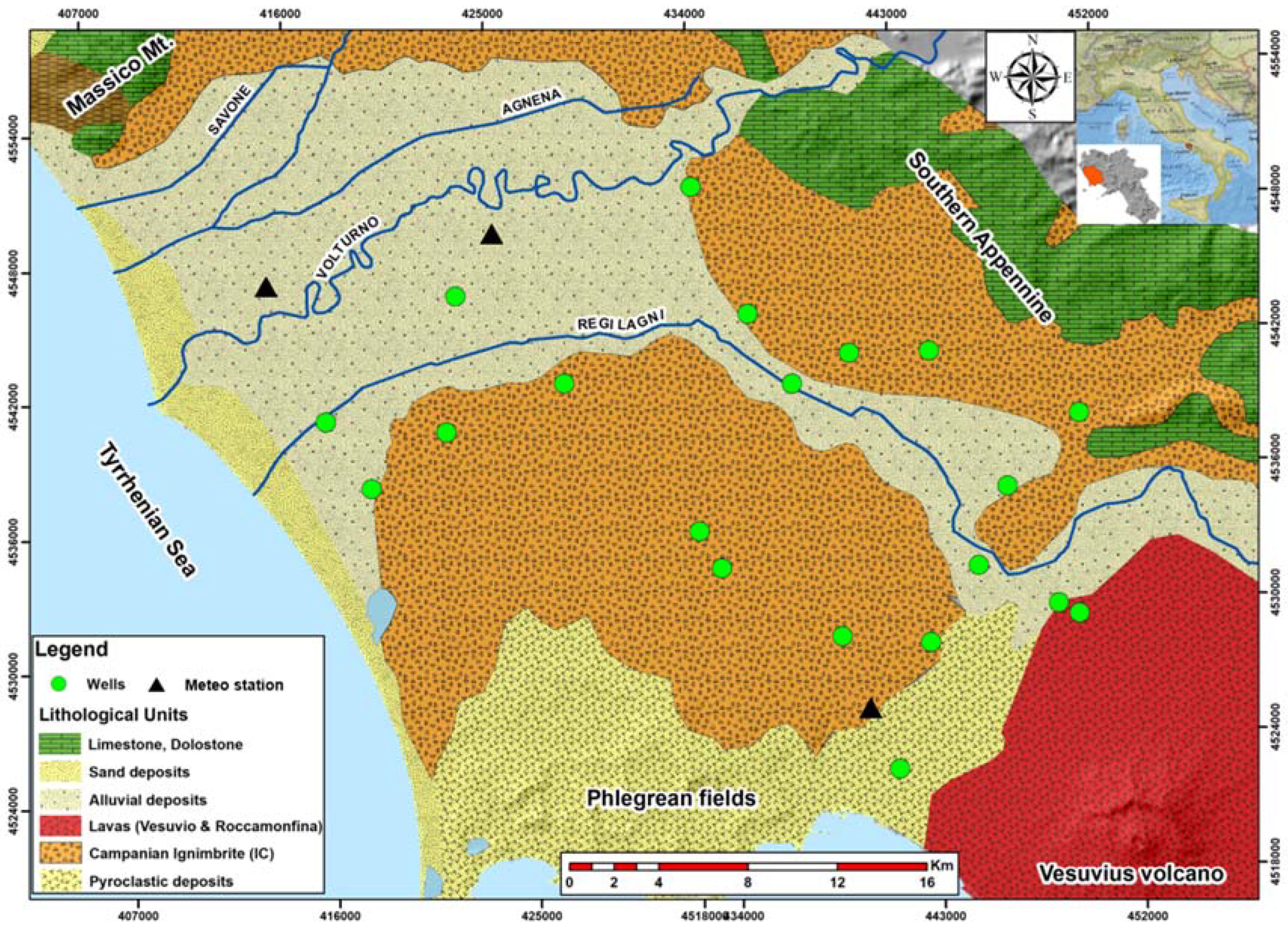
2. Materials and Methods

The study area is situated in the Campanian Plain in southern Italy (Figure 1). The Campanian Plain is bounded by the Massico Mountain to the North, by the Apennine carbonate belt to the East, and by the volcanic systems of Phlegrean Fields and Vesuvius to the South. The Tyrrhenian Sea is the outlet of the watershed and is the western boundary of the study area. The Campanian Plain comprises of two main geological units: quaternary alluvial deposits located in the center of the plain and encircled by pyroclastic deposits (Figure 1). The thickness of the aquifer can reach up to 100 m and the vadose zone decreases towards the coast [15]. The main unconfined aquifer of the CP is developed in the sedimentary formation of the terminal alluvial plain of the Volturno River. High values of hydraulic conductivity characterize the alluvial deposits (mainly gravel and sand). However, clay and peat also occurred, especially in the lowland area located in the central part of the Volturno River plain. The investigated area covers about 900 km2, the land use is heterogeneous with urban areas covering 27% of the territory (especially around Naples), while the agricultural land and pastures, covers more than 73% of the territory.
For this study, 20 monitoring wells were selected among the online available dataset of ARPA Campania [16]. The total number of groundwater temperatures were 370, distributed in approximately two campaigns per year from 2004 to 2016, excluding 2011 and 2015 where data were unavailable. The monitoring wells consist of domestic, municipal and agricultural wells, whose coordinates were recorded using a GPS. Before sampling, all wells were purged for at least three casing volumes to remove stagnant water and then temperature and other physical chemical parameters were measured in situ. The available meteorological stations were 3 with daily minimum, maximum and mean air temperatures in the last 20 years (from 1997 to 2017). The daily observed data were used to generate mean monthly and mean yearly data on air temperature. The temperature dataset was analyzed using both multiple linear regression and Pearson correlation tests via Excel 2016.

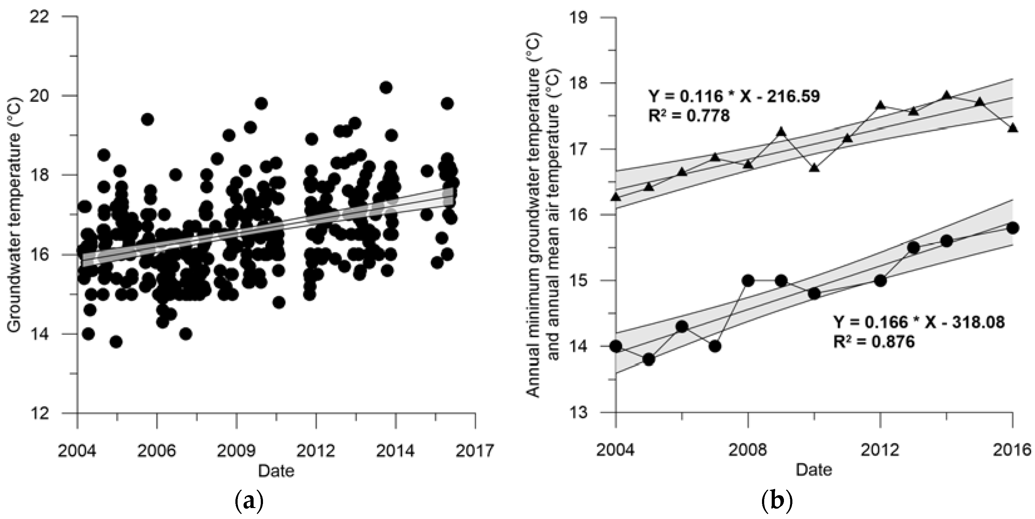
3. Results and Discussion

Figure 2 shows the trend of yearly averaged maximum and minimum air temperatures in the area during the period 2004–2016. The maximum air temperatures exhibit an increasing trend, although some outliers decrease the overall fit with linear interpolation to R2 of 0.305 (Table 1). The trend is even worst when the dataset of the last 20 years is employed, generating an R2 of 0.005 (not shown). On the contrary, the minimum air temperatures exhibit a clear increasing trend, with an R2 of 0.867 (Table 1) and the trend is maintained even using the whole dataset although the R2 diminished to a value of 0.67 (not shown). The mean air temperature trend lies between the maximum and minimum with an annual temperature increase from 2004 to 2016 of 0.116 °C. This means that the investigated area has experienced an increase of atmospheric temperatures of approximately 1.5 °C in the same period, which is in line with the observed trend for southern Italy [17].
Figure 3 shows the trend of all the observed groundwater temperatures in the area during the period 2004–2016 and the yearly averaged minimum groundwater temperatures, it can be noticed as the year 2011 and 2015 are missing from the dataset. Nevertheless, an undeniable increasing trend of groundwater temperatures is described by the annual mean minimum groundwater temperatures plot of Figure 3, with nearly all the points falling within the 95% confidence interval. In fact, the corresponding R2 is extremely high, with a value of 0.876 (Table 2) compared to the annual mean maximum and average groundwater temperatures. The annual increment is compatible with the one found for atmospheric temperatures of the area in the same period. These results should be further investigated in future studies, because recently it has been shown that both lag time and dumping of thermal regime has to be expected in aquifers [18]. In fact, the regime shifts in groundwater take place with a lag phase respect to the climate regime shifts due to both the thermal properties and thickness of the unsaturated zone. Besides, the observed groundwater temperatures could be biased by multiple factors, like the long screens of the investigated wells that could cause artificial mixing of different waters or the measurement method that could be influenced by atmospheric temperatures [19]. In addition, the land use has been changed and is continuously changing in this area [15], possibly inducing thermal shift in the unconfined aquifer.
Finally, Table 3 shows the correlation matrix between all the variables analyzed. Here the Pearson coefficients, shown in bold, denote a good correlation between the annual mean minimum, and average groundwater temperature and the annual mean minimum air temperature. In addition, also the annual mean minimum groundwater temperature has a good correlation with the annual mean air temperature. All the other parameters with an elevated Pearson coefficient but not shown bold were not selected since they are autocorrelated, e.g., minimum and average groundwater or air temperatures.

4. Conclusions

This study has shown a clear correlation between the mean minimum air temperature and the mean minimum groundwater temperature of a regional unconfined aquifer located in Southern Italy. The investigated area has experienced an increase of atmospheric temperatures of approximately 1.5 °C in the period from 2014 to 2016, which was well reflected by a concomitant increase of minimum and average groundwater temperatures. Despite the good correlation found between air and groundwater temperatures, this preliminary assessment should be further investigated to unravel possible biases due to sampling methods or due to land use changes, which could affect the interactions between the atmospheric temperatures and groundwater temperatures.

Author Contributions

M.M. conceived and designed the experiments; N.C. performed the statistical analyses; M.M., N.C. and G.B. analyzed the data; N.C. and G.B. contributed providing figures and tables; M.M. wrote the paper.

Acknowledgments

No grants have been received in support of this research and no funds have been received for covering the costs to publish in open access.

Conflicts of Interest

The authors declare no conflict of interest. The founding sponsors had no role in the design of the study; in the collection, analyses, or interpretation of data; in the writing of the manuscript, and in the decision to publish the results.

References

  1. IPCC. Climate Change 2014 Impacts, Adaptation, and Vulnerability Part A: Global and Sectoral Aspects. In Working Group II Contribution to the Fifth Assessment Report of the Intergovernmental Panel on Climate Change; Field, C.B., Ed.; Cambridge University Press: Cambridge, UK, 2014; Volume 1. [Google Scholar]
  2. Candela, L.; Elorza, F.J.; Jiménez-Martínez, J.; von Igel, W. Global change and agricultural management options for groundwater sustainability. Comput. Electron. Agric. 2012, 86, 120–130. [Google Scholar] [CrossRef]
  3. Chaouche, K.; Neppel, L.; Dieulin, C.; Pujol, N.; Ladouche, B.; Martin, E.; Salas, D.; Caballero, Y. Analyses of precipitation, temperature and evapotranspiration in a French Mediterranean region in the context of climate change. Comptes Rendus Geosci. 2010, 342, 234–243. [Google Scholar] [CrossRef]
  4. Molina-Navarro, E.; Trolle, D.; Martínez-Pérez, S.; Sastre-Merlín, A.; Jepsen, E. Hydrological and water quality impact assessment of a Mediterranean limno-reservoir under climate change and land use change scenarios. J. Hydrol. 2014, 509, 354–366. [Google Scholar] [CrossRef]
  5. Dai, A. Increasing drought under global warming in observations and models. Nat. Clim. Chang. 2013, 3, 52–58. [Google Scholar] [CrossRef]
  6. Lionello, P. The Climate of the Mediterranean Region: From the Past to the Future; Elsevier: New York, NY, USA, 2012; 592p. [Google Scholar]
  7. Bates, B.; Kundzewicz, Z.W.; Wu, S.; Palutikof, J.P. Climate Change and Water, Intergovernmental Panel on Climate Change Secretariat; IPCC Secretariat: Geneva, Switzerland, 2008; 210p. [Google Scholar]
  8. Giorgi, F.; Im, E.-S.; Coppola, E.; Diffenbaugh, N.S.; Gao, X.J.; Mariotti, L.; Shi, Y. Higher hydroclimatic intensity with global warming. J. Clim. 2011, 24, 5309–5324. [Google Scholar] [CrossRef]
  9. Hirabayashi, Y.; Mahendran, R.; Koirala, S.; Konoshima, L.; Yamazaki, D.; Watanabe, S.; Kim, H.; Kanae, S. Global flood risk under climate change. Nat. Clim. Chang. 2013, 3, 816–821. [Google Scholar] [CrossRef]
  10. Garner, G.; Hannah, D.M.; Watts, G. Climate change and water in the UK: Recent scientific evidence for past and future change. Prog. Phys. Geogr. 2017, 41, 1–17. [Google Scholar] [CrossRef]
  11. Taylor, R.G.; Scanlon, B.; Döll, P.; Rodell, M.; Van Beek, R.; Wada, Y.; Longuevergne, L.; Leblanc, M.; Famiglietti, J.S.; Edmunds, M.; et al. Ground water and climate change. Nat. Clim. Chang. 2013, 3, 322–329. [Google Scholar] [CrossRef]
  12. Green, T.R.; Taniguchi, M.; Kooi, H.; Gurdak, J.J.; Allen, D.M.; Hiscock, K.M.; Treide, H.; Aureli, A. Beneath the surface of global change: Impacts of climate change on groundwater. J. Hydrol. 2011, 405, 532–560. [Google Scholar] [CrossRef]
  13. Jyrkama, M.I.; Sykes, J.F. The impact of climate change on spatially varying groundwater recharge in the grand river watershed (Ontario). J. Hydrol. 2007, 2007 338, 237–250. [Google Scholar] [CrossRef]
  14. Stuart, M.E.; Gooddy, D.C.; Bloomfield, J.P.; Williams, A.T. A review of the impact of climate change on future nitrate concentrations in groundwater of the UK. Sci. Total Environ. 2011, 409, 2859–2873. [Google Scholar] [CrossRef] [PubMed]
  15. Busico, G.; Kazakis, N.; Colombani, N.; Mastrocicco, M.; Voudouris, K.; Tedesco, D. A modified SINTACS method for groundwater vulnerability and pollution risk assessment in highly anthropized regions based on NO3 and SO42− concentrations. Sci. Total Environ. 2017, 609, 1512–1523. [Google Scholar] [CrossRef] [PubMed]
  16. ARPA Campania. Available online: http://www.arpacampania.it/web/guest/365 (accessed on 26 January 2018).
  17. Toreti, A.; Desiato, F.; Fioravanti, G.; Perconti, W. Seasonal temperatures over Italy and their relationship with low-frequency atmospheric circulation patterns. Clim. Chang. 2010, 99, 211–227. [Google Scholar] [CrossRef]
  18. Menberg, K.; Blum, P.; Kurylyk, B.L.; Bayer, P. Observed groundwater temperature response to recent climate change. Hydrol. Earth Syst. Sci. 2014, 18, 4453–4466. [Google Scholar] [CrossRef]
  19. Colombani, N.; Giambastiani, B.M.S.; Mastrocicco, M. Use of shallow groundwater temperature profiles to infer climate and land use change: Interpretation and measurement challenges. Hydrol. Process 2016, 30, 2512–2524. [Google Scholar] [CrossRef]
Figure 1. Geolithological map with the location of the monitoring wells and meteorological stations.
Proceedings 02 00630 g001
Figure 2. (a) Annual mean maximum air temperatures recorded in the study area from 2004 to 2016 (black dots) with linear fit and the corresponding 95% confidence intervals plotted; (b) Annual mean minimum air temperatures recorded in the study area from 2004 to 2016 (black dots) with linear fit and the corresponding 95% confidence intervals plotted.
Proceedings 02 00630 g002
Figure 3. (a) Groundwater temperatures recorded in the study area from 2004 to 2016 (black dots) with linear fit and the corresponding 95% confidence intervals plotted; (b) Annual mean minimum groundwater temperatures (black dots) and annual mean air temperatures (black triangles) recorded in the study area from 2004 to 2016 with linear fit and the corresponding 95% confidence intervals plotted. .
Proceedings 02 00630 g003
Table 1. Annual increments of mean maximum, minimum and average air temperatures, with their relative R2.
Air TemperatureAnnual Increment (°C)R2 (-)
Annual mean maximum temperature0.0760.305
Annual mean minimum temperature0.1570.867
Annual mean average temperature0.1160.778
Table 2. Annual increments of mean maximum, minimum and average air temperatures, with their relative R2.
Groundwater TemperatureAnnual Increment (°C)R2 (-)
Annual mean maximum temperature0.1340.510
Annual mean minimum temperature0.1660.876
Annual mean average temperature0.1310.787
Table 3. Correlation matrix with Pearson coefficients for the selected variables. Numbers in bold are representative values.
T av GWT Min GWT Max GWT Min AirT Max AirT Med Air
T av GW1.00
T min GW0.851.00
T max GW0.730.741.00
T min Air0.830.870.731.00
T max Air0.270.480.170.431.00
T med Air0.680.810.560.870.811.00
Publisher’s Note: MDPI stays neutral with regard to jurisdictional claims in published maps and institutional affiliations.

