Article

The Concentration of Urban Functions Within Transformed City Areas Due to the Deployment of a Multimodal Transit Hub—A Case Study: Barcelona, Berlin, and London

Faculty of Architecture, University of Zagreb, Fra Andrije Kačića Miošića 26, 10000 Zagreb, Croatia
*
Author to whom correspondence should be addressed.
Urban Sci. 2025, 9(8), 327; https://doi.org/10.3390/urbansci9080327 (registering DOI)
Submission received: 4 July 2025 / Revised: 1 August 2025 / Accepted: 15 August 2025 / Published: 19 August 2025

Abstract

In the 21st century, the role of railway stations began to change, as they began to integrate various modes of transport to become multimodal transit hubs (MTHs). They are often part of urban transformation plans due to the vast and underutilized spaces associated with them. This paper aims to reveal the changes in urban functions within transformed city areas due to the development of MTHs, as well as within MTHs themselves, by utilizing a widely accepted theoretical concept: the “15-minute city”. All conclusions are drawn by analyzing MTHs in urban transformation areas of European metropolises: Barcelona, Berlin, and London. The research shows that areas previously designated only for one use—industry—become areas with diverse urban functions after urban transformation. The reduction in infrastructural areas has resulted in the concentration of urban functions within these areas. This concentration can be observed in the following two ways: urban diversity has increased, and urban functions occupy significantly larger areas than before the urban transformation. It has been established that MTHs are catalysts for comprehensive urban transformation, as indicated by economic investments largely directed toward the development of urban functions in their surrounding areas.

1. Introduction

During the 19th and 20th centuries, many European cities exhibited a tendency toward urban sprawl, leading many daily travelers to combine several modes of transport to reach their final destination. At the same time, this resulted in a decrease in the attractiveness of public transportation compared to private cars. The rapid expansion and evolution of cities in the 21st century have created new challenges and opportunities in city design, particularly concerning mobility and urban life. To ensure sustainable urban development, many cities today follow the policies of the European Union [1,2] and strive to transform their railway stations into multimodal transit hubs (MTHs). Urban development represents the complex process of planning, constructing, and managing the physical and social transformation of urban areas. This encompasses everything from the construction of new infrastructure and buildings on built and unbuilt urban land to revitalizing existing neighborhoods and addressing the evolving needs of city dwellers. It aims to enhance the livability of cities and create new economic opportunities [3]. An MTH is significantly more spatially and functionally complex than a conventional railway station. It is a recognizable place that integrates two or more (public urban or intercity) modes of transport to enable uninterrupted (fast, simple, and efficient) passenger travel. An MTH is an important part of urban space with unique characteristics, as it not only plays a role in a city’s transport system (as a Node), but also incorporates other urban functions, all for the purpose of creating a Sense of Place [4]. Sense of Place is a crucial feature of an MTH, which can create the conditions for MTHs to become a catalyst for urban transformation [5]—a process involving planning and construction on previously built urban areas that have been destroyed by inadequate approaches or neglect [6]. This, in turn, can promote further development in the part of the city in which the MTH is located. This dual role of MTHs was first introduced by Bertolini [7], who formulated the Node–Place model. The model was initially presented as a diagram with the following two axes: one representing the traffic accessibility of the hub and the other the strength and diversity of the hub’s activities. Bertolini [8] emphasized that the Node–Place model provides a conceptual framework for exploring possibilities for railway station area redevelopment and that the model requires further enhancement [9]. The MTH traffic function is the most important, followed by its role as a public space, while providing various services and business activities is significantly less important [10]. Based on the research results obtained thus far, different groups of criteria influencing MTH planning and characteristics have been identified [11]. The first group of criteria includes factors affecting the function and infrastructural equipment of the hub, such as the number of passengers and included transport modes, as well as available services and amenities. These may vary between hubs, with some having a few tobacco shops and self-service devices, some with several shops, cafes, and restaurants for passengers, and finally some with shopping centers. The second group consists of criteria derived from location characteristics: the hub’s position within the city in relation to high-demand areas, amenities in the hub’s surrounding area that can either encourage or limit the facilities within the hub, and the existence of physical plans that concurrently address both the MTH and urban transformation of the surrounding area. Lastly, it has been noted that the construction of residential and commercial buildings is more frequent when the MTH is integrated into physical plans.
Another study shows that urban morphology, studying the city as a human habitat and focusing on the visible effects of social and economic dynamics [12], plays a key role in shaping MTHs. It involves dealing with urban form, which refers to the physical appearance, organization, and size of the urban fabric [13]—as well as urban structure, understood as the arrangement and organization of physical elements within an urban space, regarding how functions are spatially distributed and how they relate to each other [14]. Additionally, it includes considerations of access networks and urban intensity, which refers to the degree of activity and social and economic interactions, typically guided by strategic documents and physical plans [15].
In previous centuries, according to the Urban Core theory, cities were viewed and planned as monocentric systems consisting of a core and a periphery [16]. Railway stations were planned and built within industrial areas on the outskirts of cities (periphery). Their role as transport buildings (as places to pass through and primarily designated for travelers) was acknowledged far more compared to their roles as venues for living and socializing [17]. This role of railway stations began to evolve during the last quarter of the 20th century. In the 21st century, cities are increasingly viewed as a polycentric system, characterized by the development of multiple urban centers, each with significant economic, social, and infrastructural functions [18,19]. In such systems, Nodes serve as urban centers [20]. As cities have expanded, railway stations have become crucial components of historic city areas [21] and are considered part of industrial heritage [22,23]. Many railway stations are situated within highly valuable urban spaces in city centers, which are often the most attractive and frequently visited parts of cities [24]. However, railway station areas are now characterized by large and underutilized zones due to the relocation of former industrial areas and cargo transport ports [25]. This creates a necessity to transform these facilities and their surrounding areas.
Railway stations that, through the urban transformation process, become MTHs, along with their adjacent areas, are fundamental determinants of urban transformation plans in Europe and beyond [26,27]. A complex set of factors, such as promoting sustainable transportation and land use, stimulating local economies, and technological development, drives these changes [28]. Bodnár and Csomós [29] noted that European examples of MTHs are not isolated projects, but key elements of large-scale urban transformation interventions aimed at developing smart cities—innovative, technology-driven cities that connect people, information, and urban elements using new technologies, with competitive and innovative commerce, smarter and more efficient urban transport, and improved quality of life [30]. The analysis of physical plans, strategies, and projects for the urban transformation of railway station areas, which have become MTHs, can provide insights into how brownfield areas around them should be developed. The goal of urban transformation is to establish new functions and services so that the resulting positive impacts can support effective urban renewal policies. In essence, the urban transformation process significantly affects the physical, functional, and environmental qualities of a city, alongside corresponding changes in property values [31]. The implementation of new infrastructure and the MTH itself can greatly influence increased demand for space in the immediate vicinity, leading to higher property values [32] compared to other urban districts. Previous research shows that commercial properties within 400 m of an MTH can be up to 16.4% more expensive, and residential properties can be around 4.2% pricier than those outside this radius [33]. Regarding the functional impact of urban transformation, the following two principles have been recognized as important: diversity and density. Urban diversity involves a mix of functions (mixed land use), while urban density reflects the average population density within a given area (the ratio of total population to the urban area it occupies) [34]. Kumakoshi et al. [35] found that urban diversity in MTH areas is associated with their density. Lower-density areas tend to show a positive correlation with functional diversity, whereas higher-density areas tend to demonstrate a negative correlation. They also emphasized the importance of encouraging diverse functions in highly dense MTH areas and the need to actively pursue this goal.
Previous research has identified the role of MTH traffic as its primary function, but has not clarified what other functions it currently performs or could potentially undertake to serve not only passengers, but also residents in the immediate surroundings. To fill this gap in the literature and to identify MTH urban functions, the urban planning concept of the “15-minute city” (15MC) was applied. It was selected among other comparable concepts, such as Transit-Oriented Development [36] and the Compact City [37], because the 15MC proposes an approach focused on essential urban functions and is believed to embody an urban structure aligned with sustainable urban development principles [38,39], as well as supporting the development of a polycentric city. Another reason this concept is suitable for this research is that it considers both the allocation of urban functions and residents’ mobility needs. The 15MC aims to develop multifunctional (diverse), walkable neighborhoods that satisfy all the daily needs of their residents. When a neighborhood is well designed and equipped with essential urban functions, people are more likely to use sustainable transportation modes (walking, biking, or using public transit), although many still commute outside the neighborhood for work or school. Short-distance connections become increasingly important, but cannot replace long-distance ones [40]. The 15MC integrates the network of short distances with the network of long distances, where the MTH provides a connection between 15MC neighborhoods and access to more distant locations [41]. It can be considered the central (or starting) point of the 15MC neighborhood.
Considering the theoretical and contextual background outlined above, this research aims to address the following questions and hypotheses:
(I)
What urban functions develop within urban transformation areas with MTHs and within MTHs themselves? To address this question, it is hypothesized that urban transformation areas are developed according to 15MC principles, as they encompass all of its urban functions, while an MTH has at least one urban function—commerce.
(II)
What is the urban structure of transformed areas with an MTH? As a possible answer, it is assumed that commercial and working areas concentrate around MTHs, while other urban functions are spread throughout the area.
(III)
What insights are provided by the economic value of urban functions in transformed city areas with MTHs into the significance of these projects? In exploring this question, it is proposed to compare the economic values of urban functions and MTHs. It is expected that the economic value of urban functions within transformed city areas with MTHs will show that investments are largely directed toward the development of urban functions in the surrounding areas of MTHs.

2. Materials and Methods

This research involves seven steps to obtain information and draw conclusions (Figure 1). The first step consists of gathering relevant international scientific research from bibliographic databases to select case studies. The most recent literature review [42,43,44,45] showed that the concept of a polycentric city appears to be the most prevalent in European countries. This was followed by another study [46], which showed an overview of 58 European cities identified as having 15MC practices. From these, metropolises located in different parts of Europe are chosen—Barcelona (Spain) in the west, Berlin (Germany) in the east, and London (United Kingdom) in the north. Cities from different parts of Europe are selected to ensure that the observed case studies represent a variety and diversity of experiences and to identify potential differences in practices, along with their positive and negative aspects. All these countries have well-developed railway networks, numerous operational hubs, and are exploring new possibilities. Since the goal of this research is to examine urban transformation areas with MTHs, the selected MTH examples analyzed here—La Sagrera Station in Barcelona, Central Station in Berlin, and King’s Cross Station in London—are cases where railway stations have become MTHs and the role of their surrounding areas has changed. The second step involves analyzing historical maps to understand the previous urban form and physical and urban planning documents from the same period in order to understand and evaluate the former urban structure (functions) of the studied areas. The time frame for observing the former urban form is chosen based on the available historical maps or orthophotographs that last displayed the railway stations before the MTH was built. The third step involves analyzing urban transformation plans for the examined areas to understand the changes in urban form and structure. Studying the current urban form is supported by open-access sources with global spatial coverage, such as OpenStreetMap (OSM) and Google Maps Platform, which provide highly accurate, georeferenced data. The urban functions are identified based on graphical and textual data from planning documents. The fourth step involves examining the selected MTH projects to determine the urban functions within those MTHs. The fifth step includes creating figures that show the urban form before and after urban transformation, as well as the distribution of urban functions before and after urban transformation, and within the MTH buildings, using the 15MC concept. The figures are created in QGIS for the transformation areas and in AutoCAD 2026 for the MTH buildings. These figures enable us to obtain quantitative data used later in the analysis of urban functions. In the sixth step, the investment value of the urban transformation projects with MTHs is estimated. These values are based on data from the available literature or are assumed proportionally based on the known data. The final step focuses on evaluating the urban functions of the selected MTH projects and their respective areas. A comprehensive evaluation of the space use of MTH areas can provide a basic understanding of the intensive utilization and optimization of urban space [47].
Since the research relies on two related scales—urban transformation and the MTH building—multiple research methods were applied. To gain a comprehensive understanding of urban functions in transformed city areas with MTHs and the role of MTHs within them, a case study analysis was utilized. This method allowed for examining how 15MC urban functions are implemented within the urban transformation areas and MTH buildings of three different cities, revealing both similarities and differences. Spatial data analysis was conducted using QGIS to map and study the spatial distribution and diversity of urban functions within the transformation areas, as well as to visualize changes in urban functions before and after transformation. A comparative analysis of the case studies based on the identified urban functions was performed to explore whether these case studies had similar or different influences on their surrounding areas [48]. Finally, a quantitative method was applied to evaluate the urban functions of the selected MTH projects and their respective areas. This method was also used to analyze the estimated investment values. The data obtained based on the authors’ figures are presented in tables and graphs, which enable a comparison between former and current urban functions, as well as between the estimated investment values across all three case studies, analysis of case study interrelations, and the drawing of overall conclusions.

Mapping Urban Functions in Urban Transformation Areas and Within MTHs

The 15MC concept, as delineated by Carlos Moreno [49], assumes that the quality of urban life is inversely proportional to the time required for commuting, particularly by car. Moreno identifies the following six categories of essential urban functions: living, working, commerce, healthcare, education, and entertainment, which should be accessible within the immediate neighborhood to enhance the quality of life in modern cities. Living refers to residential areas (housing) but excludes tourist accommodation. The other five categories include amenities that fulfill residents’ daily needs and are considered essential for quality of life. Working encompasses workplaces, while Commerce includes supply stores, gastronomy, markets, and other daily necessities. Healthcare involves local healthcare centers, hospitals, pharmacies, and dental services. Education covers all age groups, from preschool to university, along with cultural activities like museums, theaters, and libraries. Finally, entertainment pertains to various sports and recreational activities, as well as leisure facilities. The classification of specific urban functions into each of these six categories was supported by previous research [50,51,52].

3. Results

Section 3 is divided into three subsections, one subsection for each case study. Each subsection shows the urban functions within the urban transformation area and the MTH building, as well as the estimated investment value of the project for that case study.

3.1. La Sagrera Station, Barcelona

3.1.1. Urban Functions Within the La Sagrera Station Area

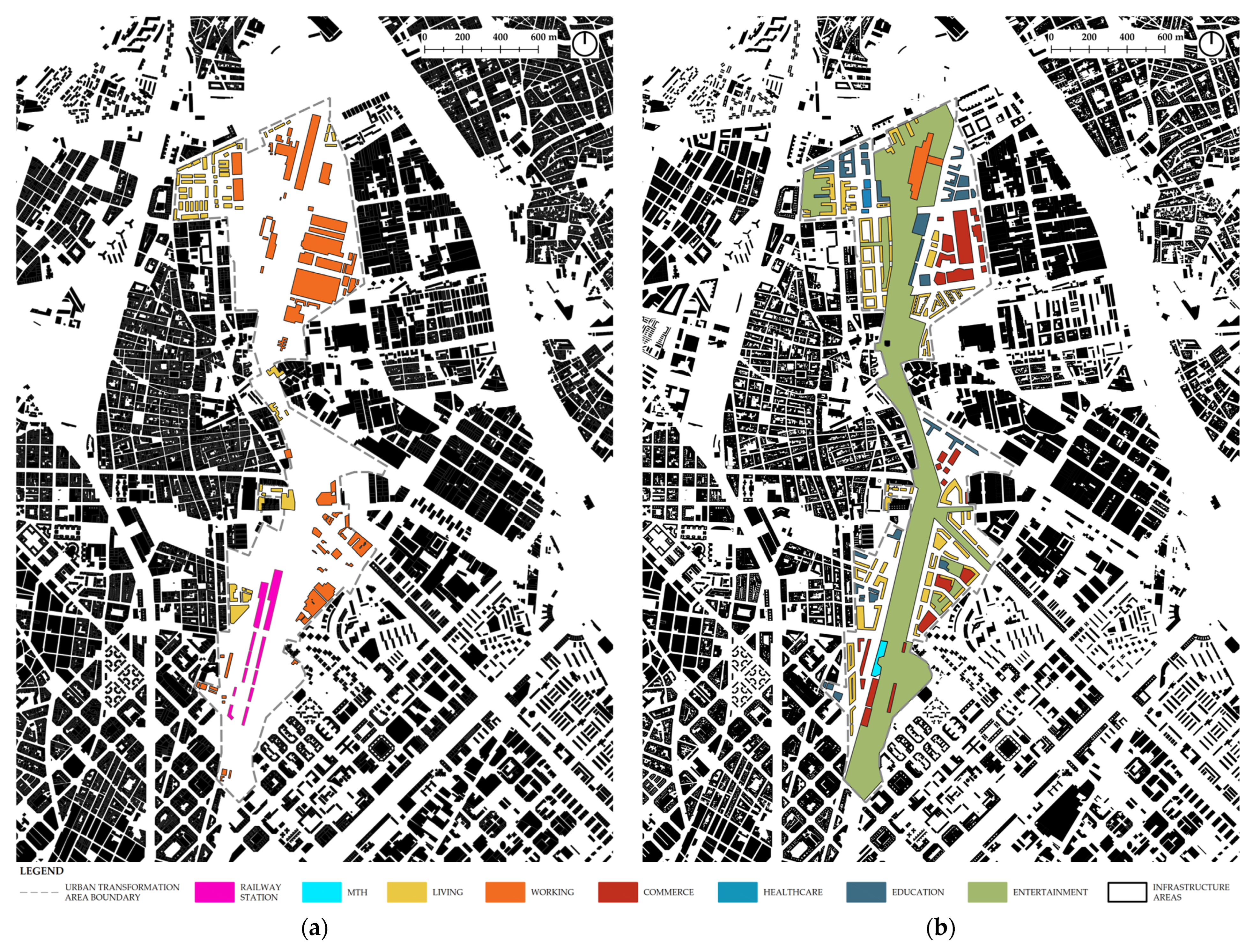
The new La Sagrera Station serves as the core of a 160-hectare urban transformation area. Originally, the La Sagrera region was rural and located on the outskirts of Barcelona. Due to industrialization throughout the 19th and 20th centuries, the area has undergone rapid transformation from a rural to an urban environment. This industrialization brought factories to La Sagrera, including the Ivanow paint factory, which is now the Nau Ivanow, an art and creation center [53]. During this time, many immigrants began settling in the barracks, predominantly found in the northwest part of today’s urban transformation area. In the 21st century, La Sagrera is not the city center, but nor is it the periphery anymore (Figure 2).
Before the urban transformation, the area was in a state of severe neglect characterized by abandoned cars, improvised migrant settlements, and waste disposal sites. The Pla General Metropolità (PGM) 1996 had already recognized this as one of the most important areas for transport connections and the city’s further development. The PGM envisioned significant infrastructural interventions and the development of an MTH that would connect railway and metro lines. Later Amendments to the Plan (PGM 2004) continued to elaborate on these directions, including the transformation of the La Sagrera terminal into a large MTH. Due to the land deterioration surrounding the future MTH, the residents demanded its development and improvement.
The aim of the urban transformation plan is to resolve both transportation and urban form issues, particularly the barrier created by railway lines [54]. To achieve this goal, a central transit hub featuring various modes of public and intercity transportation will primarily be located underground. The top level of La Sagrera Station will be integrated into a large public park known as The Linear Park. This 40-hectare park will conceal much of the underlying infrastructure, primarily railway lines, and will create a green corridor connecting the northern and southern parts of the urban transformation area, specifically the two urban districts of San Andreu and Bon Pastor, which have historically been separated. Ultimately, the park will predominantly be surrounded by residential and educational buildings, along with some commercial structures. The commercial buildings will be concentrated in the former factory area (in the northeast part of the area—now La Maquinista shopping center) and around the MTH (priority zoning for hotels), while housing and workspaces will be dispersed throughout. Several residential buildings are intended for student housing, as well as a senior living facility. The built environment of the area will undergo significant changes and will now follow the urban pattern logic of the immediate surroundings. The functions of the area will also transform completely. Industrial buildings will be replaced with residential, office, and hotel structures. In this context, the relocation of industries situated within the urban transformation area or in the immediate vicinity (Montsolís and Via Trajana industrial areas) has been planned. Consequently, all industrial buildings are set for demolition. The new urban layout will accommodate the full spectrum of 15MC urban functions, as illustrated in Figure 3.

3.1.2. Urban Functions Within La Sagrera Station

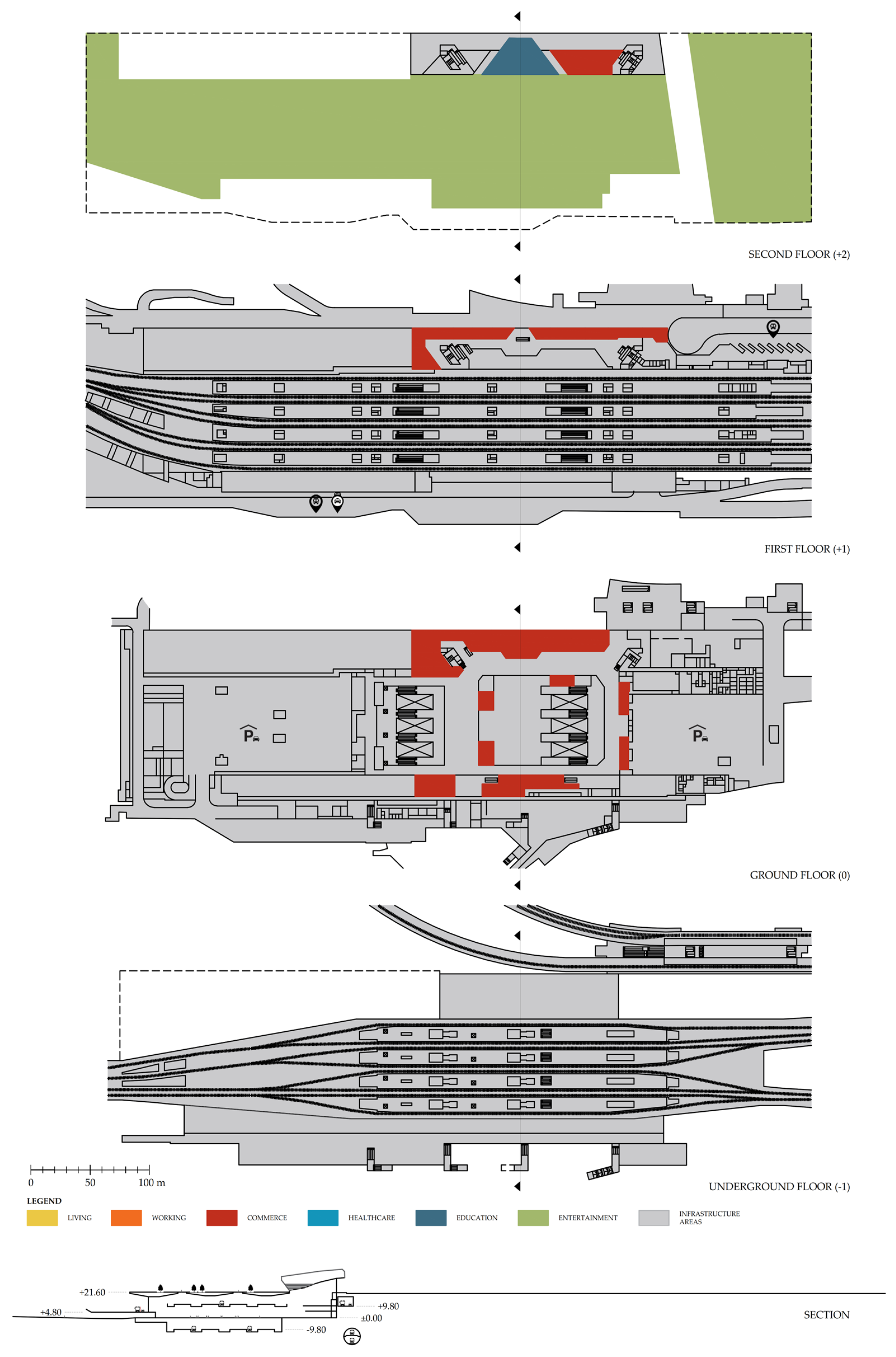
The La Sagrera Station was an important freight hub until the 1990s, when it ceased operations and all facilities were left abandoned. In 2007, demolition work commenced on the old freight station. The new MTH will feature a commercial area on the ground and first floors, while a section of the new city park will extend over the MTH rooftop. The bulkhead is designed like an outdoor auditorium facing the city park. This way, the new MTH building will integrate itself into the city (Figure 4).

3.1.3. Estimated Investment Values for the Transformation of La Sagrera Station Area

The total estimated investment value for the construction of the MTH building, with a total gross area (GFA) of 286,900 m2, is EUR 650M [55]. For the rest of the urban transformation area, including the construction of buildings with a total gross area (GFA) of 942,935 m2 [56,57] and the development of public open spaces (the areas in Figure 3 identified as entertainment and infrastructure areas), the estimated investment value is EUR 1.60B. Within this total of EUR 1.60B, EUR 72M is designated for the development of Linear Park [58]. In conclusion, the estimated value of the overall urban transformation of the La Sagrera Station area (but without the estimated investment value of construction work on underground infrastructure) is EUR 2.25B [59].

3.2. Central Station, Berlin

3.2.1. Urban Functions Within the Heidestrasse Area (Europacity)

At the beginning of the 18th century, the Heidestrasse (an axis implemented in the urban structure after World War II that connected the historical railway station (now MTH) in the south with the northern part of Berlin) was still located outside the city (Figure 5). Later, it was utilized for military purposes. In the 19th century, the Hamburger Bahnhof (later Lehrter Bahnhof) was established, and the railway began to shape this area. From that point on, the Heidestrasse area became one of the largest railway sites, initially serving as a freight yard and later as a container yard (Figure 6). However, next to Lehrter Station, from 1936 to 1943, a German Aviation Museum (German Aviation Collection) was housed in the former ULAP (Universum-Landes-Ausstellungspark or Universum State Exhibition Park) exhibition hall until it was relocated due to bombing raids [60]. This location was chosen not only because of its spacious interior and historical significance tied to Berlin’s industrial and technological heritage, but also for its easy accessibility to the public, being close to transport links that facilitated the transfer of museum objects by rail.
Thanks to strong infrastructural connections, industrial and similar facilities have established themselves in this area. There were no significant residential buildings in this area until the early 21st century. Following German reunification in 1991, its use as a container yard increased until the depot’s relocation in 2003. Therefore, this area became available for new developments. In 1998, the construction of today’s MTH began, marking the start of ideas and planning for the transformation of the MTH area. With the opening of the MTH in 2006, the Heidestrasse area gained a new central position in the city’s structure. The Masterplan was adopted by the Senate in 2009 [61], and soon after, this area increasingly became the focus of urban development plans for various parts of the region.
A new urban district named Europacity, which spans over 60 hectares, is envisioned as a place where living and working can occur simultaneously, which is well-connected with public local and long-distance transportation. A mix of building typologies within six sections of Europacity ensures a blend of urban functions of almost all 15MC categories (living, working, commerce, education, and entertainment), as illustrated in Figure 6. The urban structure of this area has completely transformed. Instead of a fragmented urban layout with numerous smaller buildings, large building blocks are now being planned and constructed. Only a few former warehouses in the western and southeastern parts of the area have been retained and reused.
The area around the MTH (Am Hauptbahnhof) features two office skyscrapers with spaces for gastronomic use and a conference area. Additionally, there are two office buildings and two hotels with restaurants, an auditorium, and a conference area. The art campus (Am Kunst-Campus) includes some former warehouses that have been transformed into the Hamburger Bahnhof—Nationalgalerie der Gegenwart, which serves as a museum of contemporary art, galleries, and studios. The entrance building has functioned as a museum since the early 20th century, contributing a unique cultural character that can trigger further urban transformation. The southwest boulevard consists of existing peripheral building blocks. These buildings have been integrated into the new urban structure, repurposed as office and service buildings. The ground floor areas along Heidestrasse feature small, individual retailers and restaurants. In the vicinity of the city harbor (Am Stadthafen), the emphasis is on residential use, but towards Heidestrasse, there are also local restaurants, services, and hotels. Attractive green public spaces and the waterfront location provide opportunities for leisure activities. The Nordhafen Park extends around the entire northern harbor basin of the district. The Boulevard West stands out for its central location within Europacity. It is primarily a residential area with a few office spaces on the upper floors and diverse urban use on the ground floor, predominantly for commercial purposes. Lastly, the area near the north harbor (Am Nordhafen) accommodates a great variety of uses focused on offices and services.

3.2.2. Urban Functions Within Berlin Central Station

Berlin Central Station (Berlin Hauptbahnhof), one of the largest MTHs in Europe, is located in the Berlin City Center, near the government district. It was opened in 2006, after nearly eleven years of construction on the historical site of the former Lehrter Bahnhof (which was destroyed in World War II and demolished in the 1950s) [62].
The multi-story shopping center has become an integral part of the new Berlin Central Station (MTH), featuring a variety of clothing and cosmetics stores, as well as a food court and pharmacy, spread across three levels of the MTH. All food and shopping areas are situated near the ticket office and lounges for travelers. Furthermore, there is no other shopping center within Europacity except this one in the MTH. Two office towers rise above these three floors (Figure 7).

3.2.3. Estimated Investment Values for the Transformation of Heidestrasse Area (Europacity)

The total estimated investment value for the construction of the MTH building, with a total gross area (GFA) of 65,000 m2, is EUR 700M [63]. For the rest of the urban transformation area, including the construction of buildings with a total gross area (GFA) of 819,000 m2 [64] and the development of public open spaces (the areas in Figure 6 identified as entertainment and infrastructure areas), the estimated investment value is EUR 1.00B [65]. In conclusion, the estimated value of the overall urban transformation of Europacity (but without the estimated investment value of construction works on the underground infrastructure) is EUR 1.70B.

3.3. King’s Cross Station, London

3.3.1. Urban Functions Within the King’s Cross Area

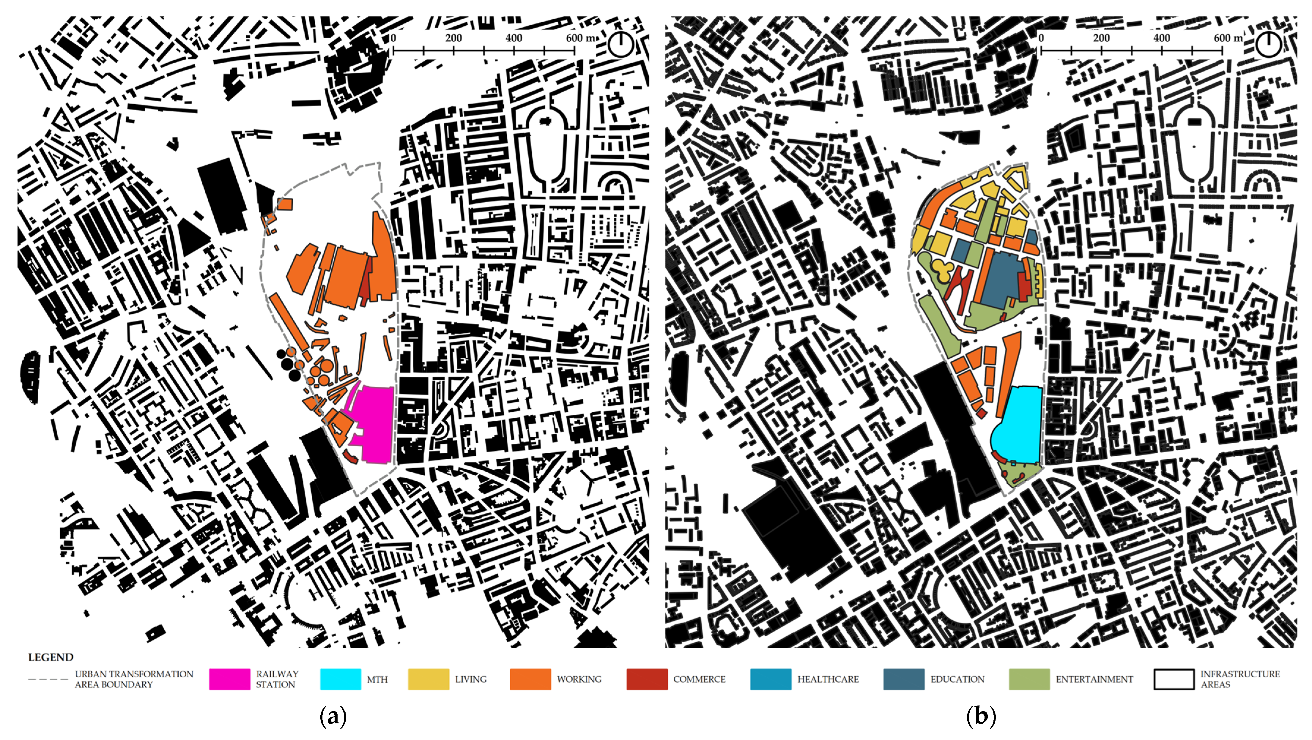
In the 19th century, King’s Cross Station was a significant industrial transport hub. With the completion of Regent’s Canal in 1820, King’s Cross Station became connected to industrial cities in the north, which brought goods and industry to this area [66]. However, by the late 20th century, the area was characterized by abandoned buildings, railway sidings, warehouses, and contaminated land (Figure 8 and Figure 9). With the arrival of the 21st century, new ideas for transforming the King’s Cross area emerged.
The first 2004 London Plan—Spatial Development Strategy for Greater London [67] envisioned King’s Cross as the most accessible location in London by transforming King’s Cross Station into one of the largest MTHs in the city core. The 2004 London Plan also predicted that major infrastructure investments, upgrades, and connection improvements would act as a catalyst for the transformation of the King’s Cross (St. Pancras) area in response to a significant increase in daily travelers and users. Furthermore, the area was identified as one of the “Opportunity Areas” due to its connection with Regent’s Canal, as waterside locations are deemed crucial for regeneration and economic growth in London. The 2004 London Plan, due to the central location and effective public transport accessibility of the area, supports high-density business development, as well as housing. Conference facilities could also be planned for satisfactory integration, along with other activities. The development plan should consider the historic features of the site as part of the new urban structure, accommodating new urban functions to create a sustainable business and residential community reliant on minimal car use. The King’s Cross Masterplan 2004 established detailed guidelines for urban transformation of the entire area, especially in terms of spatial relationships and heritage conservation [68].
The King’s Cross urban transformation area covers about 34 hectares of former industrial and rail land in central London, located north of King’s Cross Station and east of St. Pancras Station. This program has turned a neglected area of London into a new, vibrant mixed-use urban space [69].
The northern section of the transformation area (north of today’s Handyside Street) is a residential area, as well as an office area, with Cubitt Park at its center. Next to Cubitt Park and Handyside Street, there is an educational center known as the Aga Khan Centre. The ground-floor parts of residential buildings facing the streets are used for restaurants and shops. Just one building to the northeast of Cubitt Park has additional care homes on its upper floors. Moreover, two buildings for student housing can be found on the northwest, along with a fitness center on the southeast of this section.
The King’s Cross area has around 30 valuable buildings and structures from the industrial era that have been refurbished and reused. These buildings are located within a conservation area, which covers almost the entire area south of today’s Handyside Street.
Between Handyside Street to the north and Regent’s Canal to the south lies a cultural and educational center of the area. At the heart of this area, there is a former Goods Yard Complex, which comprised the Granary Building and the Eastern and Western Transit Sheds. The Granary Building, alongside the Eastern Transit Shed, is now an arts college (Central Saint Martins, part of the University of the Arts London). The Western Transit Shed has been transformed into office space with shops and restaurants along Stable Street. The development of the Granary Complex was of great importance, as the area became attractive to young people and students. This marked the beginning of the reuse and revitalization of this part of the city, which also encouraged further development and the construction of residential buildings.
Next to the Granary Complex is the West Handyside Canopy (formerly a fish market), which is now used as an event space and for a weekend market. The eastern edge of this market is marked by the Midlands Goods Shed (formerly a warehouse), which now serves as an office space, with a restaurant on the ground floor and an education center on the upper floor. On the western side of the Granary Building, facing Cubitt Square, there is yet another educational and cultural center.
Unlike Europacity, in the case of the King’s Cross area, the shopping center (with shops, bars, and restaurants) is located near the MTH at Granary Square, housed in former coal drop buildings. In both cases, these shopping centers maintain local and regional connections, and their location within the railroad impact zones ensure a sufficient number of consumers [70].
On the central zone edge, there are four primarily residential buildings, the following two of which have been reused: Tapestry and Gasholder Triplet. On the ground floor of one of the buildings is a primary school and a school for deaf children. The school is located next to former Gasholder No. 8, which has been transformed into an urban park and playground.
Alongside Regent’s Canal, there is plenty of green space, especially on the south of the Canal, where the two-hectare Camley Street Natural Park is situated.
Finally, the southern section of the transformation area (next to the MTH) is mainly a business area. Only on the ground floors of these buildings can some other activities, like shops and restaurants, be found. Only the Great Northern Hotel, which is adjacent to the MTH, has maintained its function as a hotel.
In conclusion, we may say that the King’s Cross area has transformed from a brownfield site to become a high-quality mixed-use neighborhood, encompassing almost the entire range of functions of the 15MC (Figure 9).

3.3.2. Urban Functions Within King’s Cross Station

In 2012, the renovated and extended King’s Cross Station reopened. The complete restoration of the historic train station building and its expansion in the scope of constructing Western Concourse Hall [71] transformed the station into a modern and vibrant MTH.
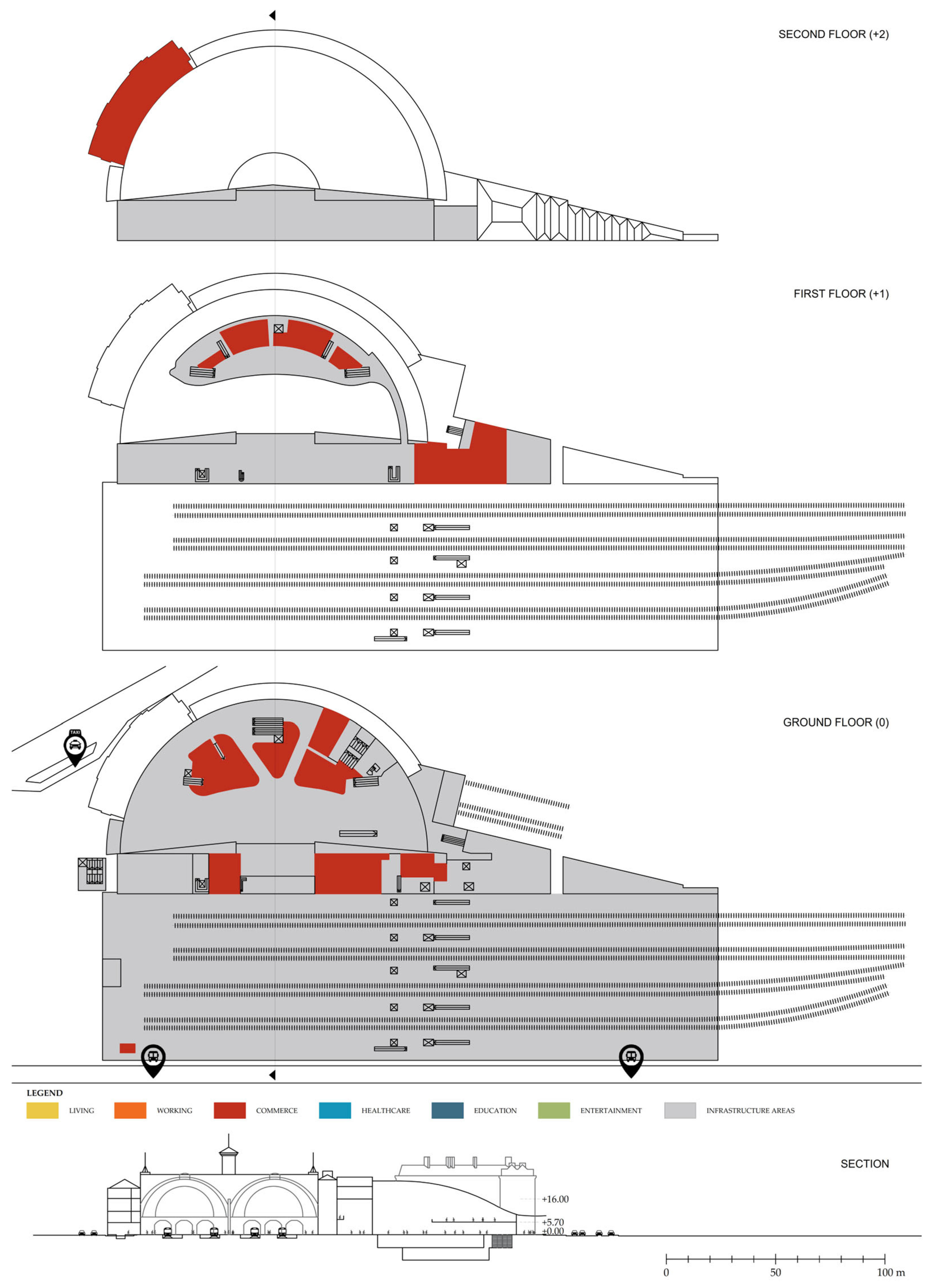
There are many shops, restaurants, and bars. The new Concourse features a mezzanine that serves as a new departures lounge. Seating is not always attached to restaurants and cafes, and is separated from the ground-floor retail area as well. The new King’s Cross Station attracts many passengers, but also tourists, as the station includes Platform 93/4 from the Harry Potter movies. King’s Cross Station has no other urban functions aside from commercial (Figure 10). However, considering the number and diversity of urban functions in the surrounding area, the commercial facilities within King’s Cross Station primarily serve passengers and tourists, rather than the residents of this area. For the residents of the area, King’s Cross Station is mainly just a transit hub that connects them to other parts of the city.

3.3.3. Estimated Investment Values for the Transformation of the King’s Cross Area

The total estimated investment value for the construction of the MTH building, with a total gross area (GFA) of 47,800 m2, is EUR 630M [72]. For the rest of the urban transformation area, including the construction of buildings with a total gross area (GFA) of 713,090 m2 [73] and the development of public open spaces (areas in Figure 9 identified as entertainment and infrastructure areas), the estimated investment value is EUR 2.80B. In conclusion, the estimated value of the overall urban transformation of the King’s Cross area (but without the estimated investment value of construction works on the underground infrastructure and after the conversion from British pounds (GBP) to Euros (EUR) according to the exchange rate in July 2025) is EUR 3.43B [74].

4. Discussion

The discussion is divided into two subsections. The first one discusses urban functions and comprises four key components. Firstly, an overview of MTHs’ impact on urban form has been outlined. This is followed by a detailed analysis of the urban transformation areas and MTHs according to each one of the six urban functions of Moreno’s 15MC. Lastly, the relation between 15MC urban function areas, infrastructure, and MTH areas was analyzed. In the second subsection, the estimated investment values of the case studies are presented in tables, providing a basis for comparison and further analysis.

4.1. Concentration of Urban Functions Supports Urban Diversity

Once, railway stations, and now MTHs, had a profound impact on cities’ morphology, occupying a significant amount of land [75]. This study aims to demonstrate that, in the past, railway stations were a structuring element in the same way that MTHs nowadays are determinant in causing profound urban transformations. In all the cases analyzed, railway stations were built on the outskirts of a city, but as the city expanded, they eventually became part of the inner-city area. Subsequently, former industrial zones transformed into mixed-use areas. As the author’s analysis indicates, MTH construction entailed the demolition of existing buildings and changes in the use of the surrounding space, as well as the user profile (Table 1). In all case studies, during the transformation of railway stations into MTHs, alongside inevitable infrastructure improvements, efforts were made to eliminate the physical barriers that railways create within the urban fabric. In Barcelona, this barrier was addressed by planning a city park over railway lines. Conversely, in Berlin and London, the railway was placed underground, creating a significant amount of space for new urban facilities.
The urban transformation of the MTH areas in all analyzed cases had a strategic urban role. Firstly, all three cities aimed to incorporate brownfield zones into the urban fabric, connecting them with the surrounding city quarters. In the city of Barcelona, this was pursued through the implementation of a linear city park, and in the other two cities, through planning a complex street network and waterfront developments. Furthermore, the city of Berlin aimed to reduce pressure on the historic city center by guiding urban growth toward a previously neglected area. Finally, the cities of Berlin and London aimed to boost their economic position in the global world based on the assumption that improved transport connections via an MTH will attract international investors to the area, or rather, business and finance services. When the urban transformation plans for the King’s Cross area began, the city of London was the number one financial center in the world. Finance and business services were dominant sectors in the UK economy, and that led to a dramatic boom in demand for office space [76]. The King’s Cross area, with excellent transport connections, has been seen as a potential financial and business center since the 2004 London Plan.
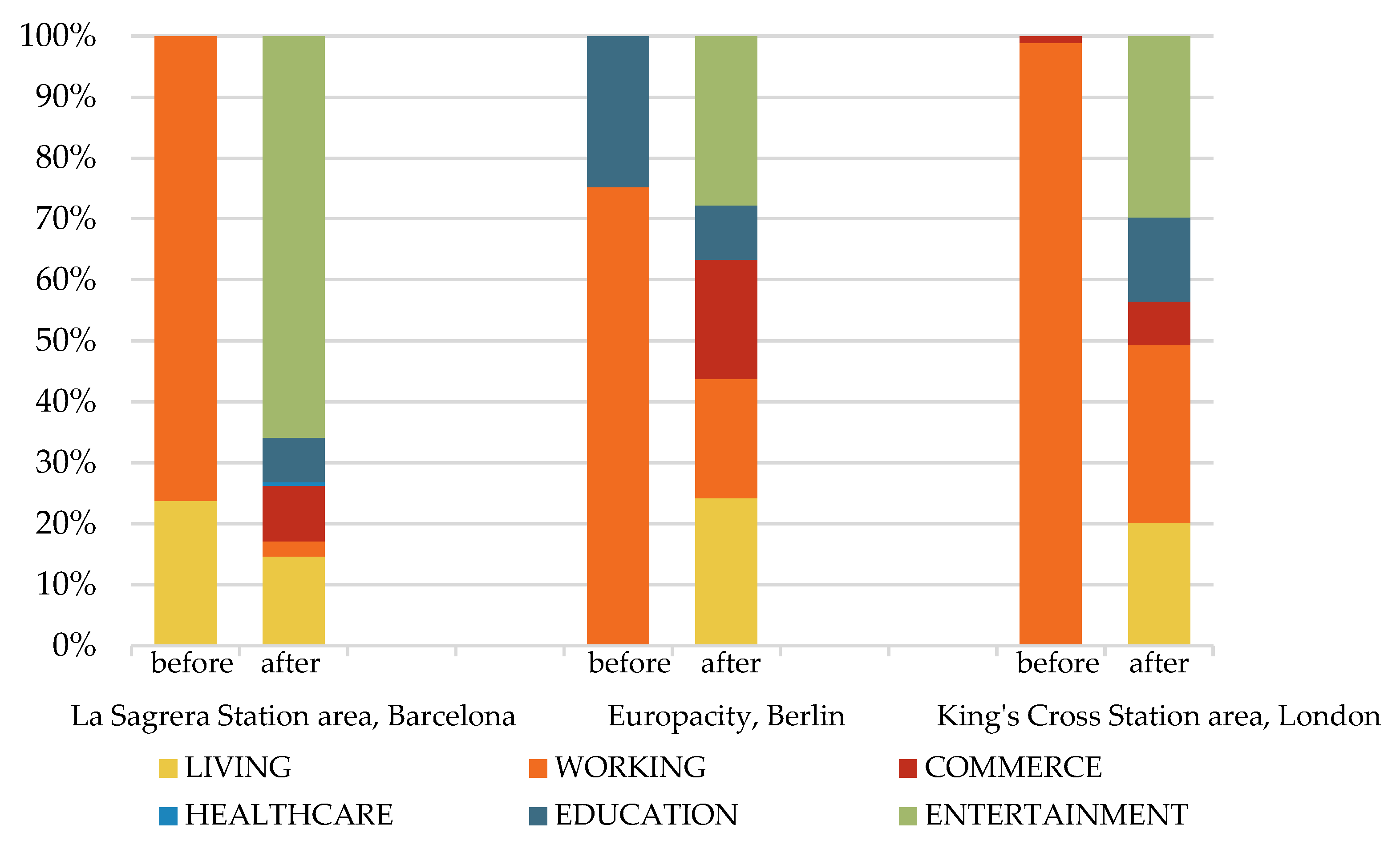
As shown in Figure 11, residential buildings (known as barracks) previously existed only in the La Sagrera Station area. The urban transformation plan for this area provided 25000 new housing units, of which 40% will be protected. The transformation of areas designated for residential use and an increase in housing supply, particularly in the protected housing category, are outcomes of the City Administration’s efforts to stabilize and reduce rental and purchase prices [77]. In the case of Europacity in Berlin, the percentage of social housing is significantly lower, as the project has primarily been developed through private investment, while the La Sagrera transformation project continues to receive funding from the city budget and EU funds. Of the approximately 3000 apartments planned within the Europacity area, only 9% (or 257 apartments) will be social housing subsidized by the Berlin government [78]. The additional 215 social housing units may not be implemented as initially intended, as the site owner decided to construct high-priced micro-apartments instead [79]. Similar to Europacity, the King’s Cross urban transformation project illustrates this trend, having been funded by a public–private partnership. The King’s Cross Opportunity Area Planning & Development Brief (2004) sets a requirement for at least 1000 housing units planned within the area, but it also states that a number of 1800 housing units is more desirable. At least 35% of that number should have been designated for social housing. Ultimately, 2000 housing units were built, of which only 10% were allocated for affordable housing [80,81,82,83]. It can be concluded that areas transformed with funding from private investors will likely have a smaller percentage of social housing, as it is less profitable for developers.
Working areas have been diminished, yet they continue to exist within the urban structure. However, sites initially designated for industrial use (factories and warehouses) have now been converted for office use (office buildings). The development of high-end office space and up-market accommodation creates a high probability of rising rental rates in adjacent wards [84]. In other words, the gentrification in these areas is quite possible and could be expected.
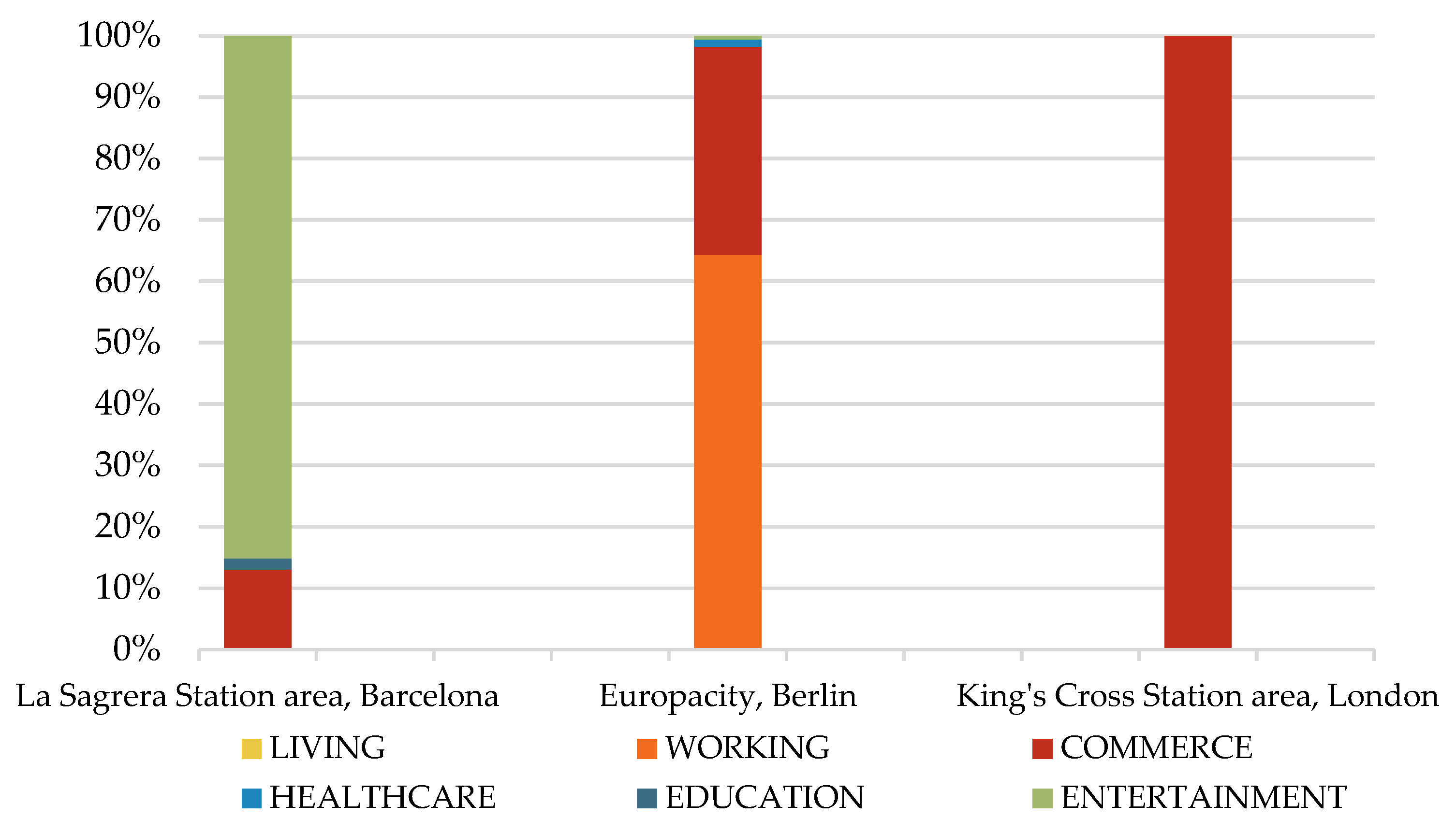
In all analyzed cases, commercial areas are planned nearby, as well as within the MTH (Table 2). Hotels are located in the immediate vicinity of all three hubs. Concerning King’s Cross Station, a hotel is attached to the MTH building. This way, shopping centers and hotels have local and regional links, and their location in the railroad impact zone ensures a sufficient number of consumers [85].
Healthcare, as a primary function within the urban transformation area, was identified only in the La Sagrera Station area, manifested by a single institution (one polyclinic). According to the Node–Place model, a high level of accessibility may drive demand for the development of this urban function. However, a high concentration of activities, such as those drawn by healthcare centers [86,87], may necessitate further MTH development. Optimizing MTH accessibility could negatively impact the livability and attractiveness of the area. Therefore, although healthcare centers (hospitals) typically have access to main roads and good connections with public transport, which MTHs provide, their significant potential to attract traffic explains why these centers have not been located near MTHs. In contrast, pharmacies, doctors’ and dentists’ offices, and similar healthcare facilities are incorporated into residential and commercial buildings throughout the urban transformation area as a secondary use.
Education and entertainment areas play a crucial role in advancing urban transformation. MTH construction is followed by the establishment of cultural centers or similar venues that attract visitors to the area. These spaces are designed and developed to create a Sense of Place for the location. In the case of Europacity in Berlin, the art campus was completed in April 2009 and became the first project finished within Europacity. On one hand, the art campus served as a gateway to the future residential and business quarter; on the other hand, it functioned as a connecting element between the MTH and the rest of the urban transformation area [88]. It also emerged as a vital location for artists and art enthusiasts. The opening of the art campus was followed by the commencement of construction on the first office tower in Europacity in November 2009. A similar trend can be observed at King’s Cross in London, where the completion of the University of Arts spurred further urban transformation and the development of residential buildings.
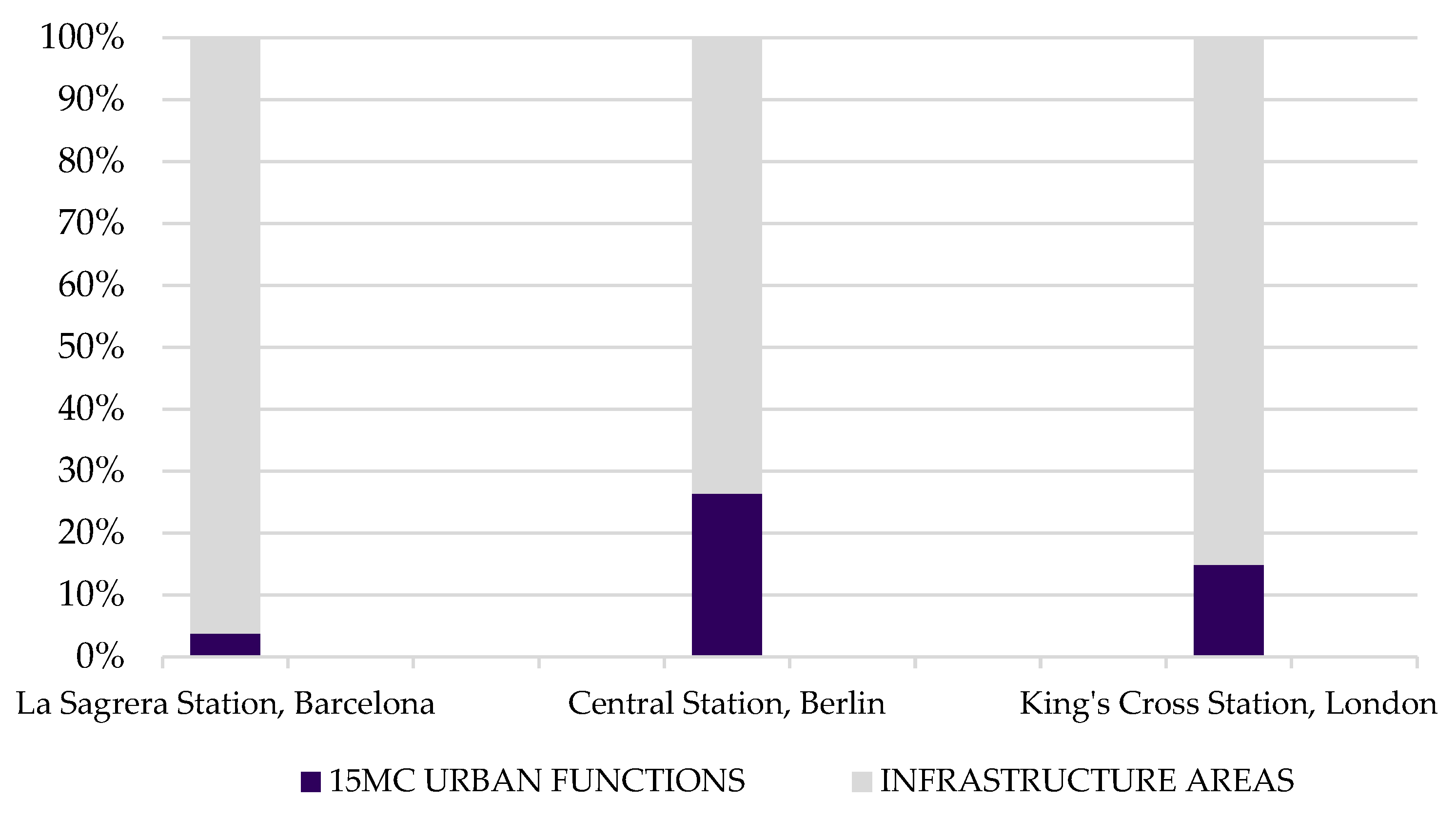
The transformation from a station to an MTH has redefined the use of these buildings. They are no longer just a Node, although the building area intended for transport still dominates compared to the building area intended for other urban functions. At La Sagrera Station, the building area intended for transport covers approximately 96% of the MTH, whereas at King’s Cross Station (74%) and Central Station (85%), this number is slightly lower (Figure 12).
MTHs can feature shopping centers (Figure 13) within the urban transformation area to primarily satisfy passengers’ needs. In two of the three case studies (in Barcelona and London), in addition to the one in the MTH, there was one additional shopping center planned. However, their role as a Place does not have to be restricted to a shopping facility. MTHs can perform a wider range of optional and social activities [89]. Beyond its function as a shopping center, Central Station in Berlin also serves as an office building, and La Sagrera Station in Barcelona is part of the city park. Cultural memories and heritage play important roles in shaping a Sense of Place [90]. In this context, King’s Cross Station, as a renovated heritage building, has a higher potential to become a Place because it is more identifiable and recognizable to the local community. In contrast to previous research [10], the results of this research show that within the MTH, traffic function is dominant, followed by commercial and business activity, while areas intended for leisure and social interaction remain the least developed.
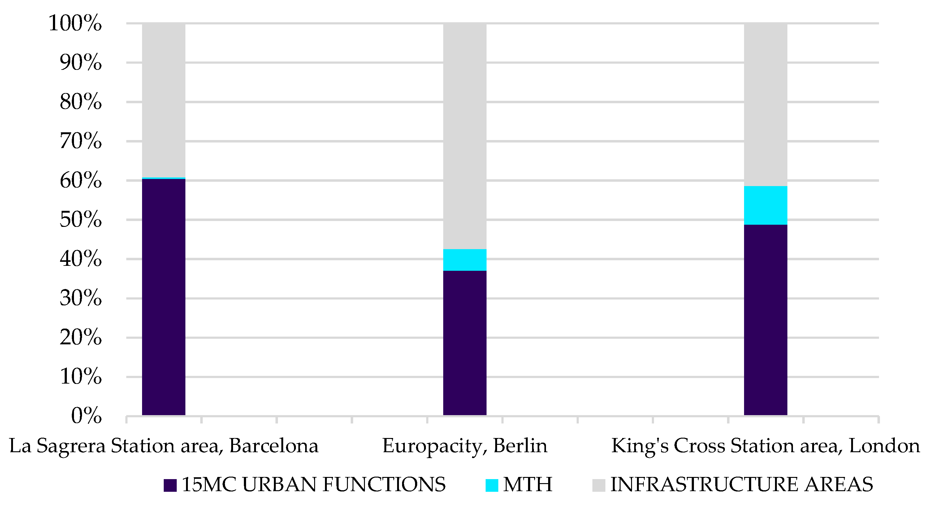
In all cases analyzed, the MTH building was finished or opened and became operational when the urban transformation of the surrounding area had started. Accordingly, MTH buildings can be considered as a catalyst for the urban transformation of the surrounding area, which confirms the results of previous research [6,26,27,29]. As shown in Figure 14, the MTH building that serves as a catalyst for the urban transformation of the surrounding area covers from approximately 4% (La Sagrera Station) to 10% (King’s Cross Station) of the overall urban transformation area. Infrastructure areas now encompass from around 40% (La Sagrera Station and King’s Cross Station areas) to 57% (Europacity). However, this percentage is significantly lower than before the urban transformation, when it ranged from 70% (La Sagrera Station and King’s Cross Station areas) to 80% (Europacity). Despite the increase in transportation facilities, MTHs do not occupy a substantially larger area than former stations, and the infrastructural areas within the urban transformation zone have been considerably reduced. In the case of King’s Cross, the MTH is 9% larger than the former station, while infrastructure areas have been reduced by 30%. Only in the case of Berlin does the MTH occupy an area 70% larger than the former station, while the reduction in infrastructural areas (around 26%) is smaller than the increase in the hub’s surface. The La Sagrera Station is the only analyzed case where the above-ground area of the MTH is smaller than that of the previous station, while the infrastructure areas were reduced by 67%. This reduction in infrastructural areas has resulted in the concentration of urban functions within transformed city areas.
To sum up, within transformed city areas with MTHs, all 15MC urban functions are developed. Most of the working and commercial areas planned within the urban transformation area, in all three cases analyzed, surround the MTH. On the other hand, residential areas are located in sections of urban transformation areas that are furthest from the MTH, and education and entertainment facilities are dispersed throughout the area. Meanwhile, the MTH, in addition to its traffic function, serves as one of the shopping centers. Concentration can be observed in two ways. First, the number of urban functions in the area has increased (from two to all six of the 15MC urban functions in the La Sagrera Station area, and from two to five 15MC urban functions in the case of Europacity and King’s Cross areas). In other words, urban diversity has increased. This may be interpreted as the result of a planned approach to urban transformation, as suggested by Kumakokoshi et al. [35]. Secondly, the urban functions occupy significantly larger areas than before the urban transformation. Lastly, these results confirm our first (I) and second hypotheses (II) listed in the Section 1.

4.2. Prevalence of Investment in Urban Transformation Area over MTH

Based on the data presented in Table 3, it can be observed that the construction cost per square meter of built space is highest in the case of London (King’s Cross area), with a price of EUR 3847 per square meter, followed by Barcelona (La Sagrera Station area), with a price of EUR 1548 per square meter, and Berlin (Europacity), with a price of EUR 1119 per square meter. As the urban transformation of the La Sagrera Station area has only just begun, the market value of the planned apartments is still unknown. However, in the case of Europacity, the average price per square meter of an apartment is between EUR 9000 and EUR 11,000. The price of an apartment in the Europacity between 2015 and 2023 has increased by approximately 60% [91]. In the King’s Cross area, the price is even higher, with an average price per square meter ranging between EUR 8600 and EUR 14,740 [92]. New build property prices in the King’s Cross area increased by 106% from 2011 to 2019 compared to the rest of the zone (London 1—Central London), with a 19% increase for the same period [93]. These results confirm the findings of previous research [31,32]. Therefore, it is likely that the same trend will follow the La Sagrera Station area in Barcelona. Nevertheless, these projects are always in public interest. In this respect, local authorities can set specific requirements and regulations. For example, local authorities may set the price of certain apartments within the urban transformation area, which can only be purchased by eligible buyers who fulfill defined economic and social conditions. Furthermore, it is also possible to determine the number of apartments within each planned building to be allocated for households unable to afford accommodation at market prices. In the case of the King’s Cross area, the London Plan set the number of affordable apartments that should be built within the urban transformation area.
As shown in Table 4, the total estimated investment value for the construction of the MTH buildings is approximately the same, despite the construction taking place during different periods. However, a significant difference in the price per square meter can be observed—EUR 13,179 for King’s Cross Station, EUR 10,769 for Berlin Central Station, and EUR 2249 for La Sagrera Station in Barcelona. It is also worth mentioning that only in the case of King’s Cross Station does the indicated price represent the cost of upgrading the existing building (the construction of the Western Concourse Hall), while in the case of La Sagrera Station and Berlin Central Station, the indicated price represents the cost of construction of the new building.
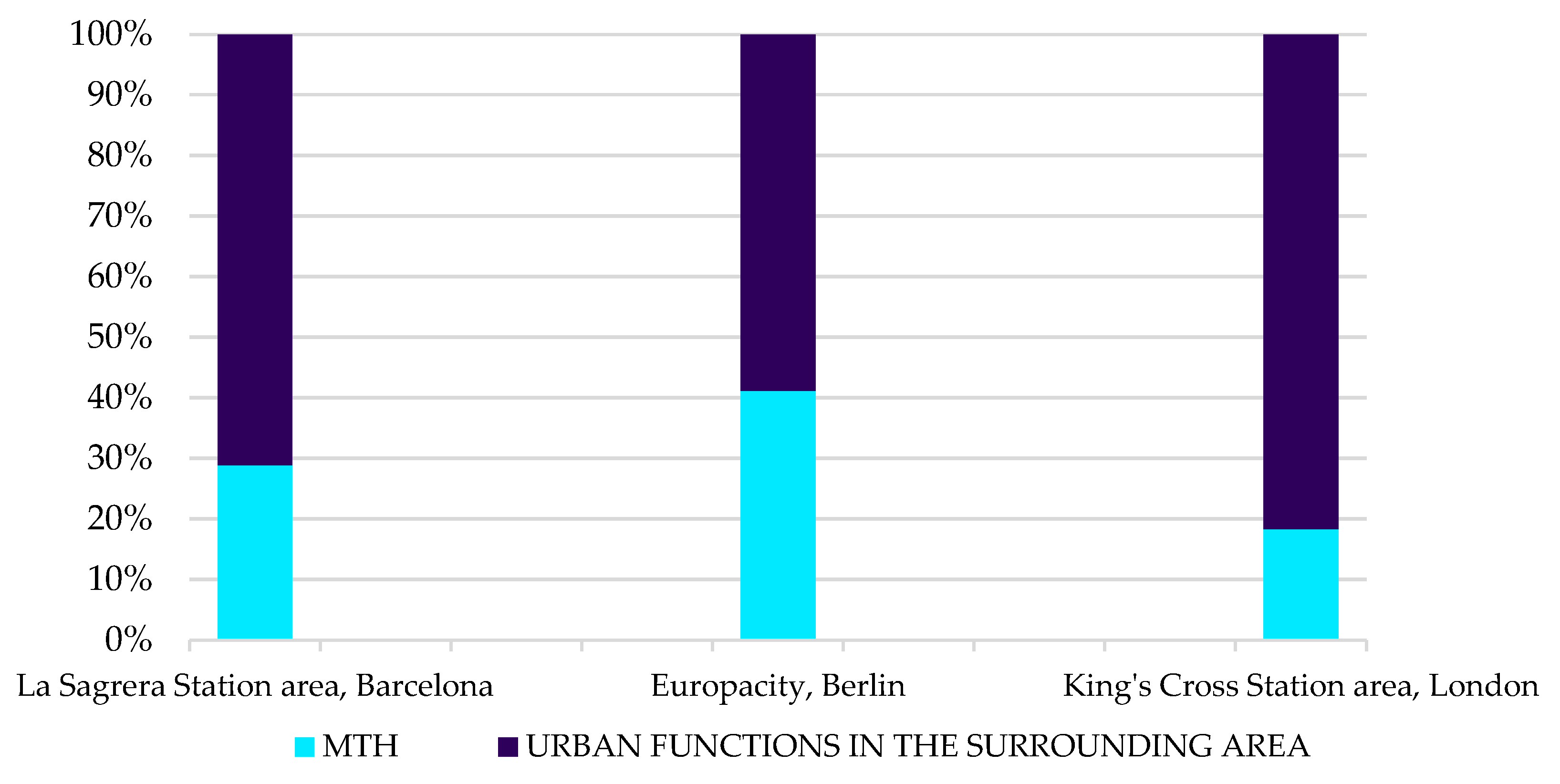
As can be observed in Figure 15, the percentage of the investment in the MTH building within the total funding allocated for the full scope of the urban transformation project is 18% in the case of King’s Cross Station, 28% in the case of La Sagrera Station, and 41% in the case of Central Station. In addition, the percentage of the investment in the urban functions in the surrounding area (within the urban transformation area) is 82% in the case of the King’s Cross Station area, 72% in the case of the La Sagrera Station area, and 59% in the case of Europacity. This indicates that MTHs are catalysts for comprehensive urban transformation, as the estimated investment values are largely directed toward the development of urban functions in their surrounding areas (Hypothesis III).

5. Conclusions

This research explores a highly relevant issue related to the transformation of railway stations into MTHs in three European metropolises—Barcelona, Berlin, and London—which is presented in the context of the polycentric city and 15MC.
Railway stations once served passengers only, while the areas around railway stations were primarily adapted for warehouses. Through time, railway stations have had to incorporate other modes of transport, especially buses and cars, to meet the needs of the modern city. The case studies presented in Section 3 and Section 4 show various attempts to create modern MTHs by the further development of existing railway stations, which will also serve the daily needs of non-travelers.
Section 4 shows that the MTH area can have multiple functions around a highly connected MTH. They affect their surrounding area, as they adopt some urban functions of the 15MC to serve the area in which they are located. However, activities inside the MTH building (its role as a Place) are mostly limited to the creation of shopping centers. Often, these shopping centers are oriented towards travelers only, so there is still a need for the implementation of others within the urban transformation area.
Transport and accessibility remain the primary reasons why other urban functions cluster around MTHs. Working and commercial areas are always planned as close to the MTH as possible, sometimes even within the MTH, as evidenced by the case of Central Station in Berlin. In contrast, residential areas are located in the sections of urban transformation areas that are furthest from the MTH. The residential use percentage is almost the same in all analyzed cases, ranging from 15% to 25%. Education and entertainment facilities are dispersed throughout the area. They are often used as a tool for attracting people back to abandoned areas, encouraging further transformation. The ratio of working and commercial areas compared to public spaces (education and entertainment) varies depending on how the project is funded (public–private partnership or the city budget and EU funds), as well as the overall development vision and needs of the city. Healthcare is the least integrated function within urban transformation areas, but it is often included as a secondary use in specific mixed-use buildings. In conclusion, areas that were previously designated for one primary use—industry—after urban transformation, become areas with diverse urban functions (mixed-use areas) according to the principles of the 15MC. The reduction in infrastructural areas has resulted in the concentration of urban functions within transformed city areas with an MTH. This concentration can be observed in the following two ways: urban diversity has increased, and at the same time, urban functions occupy significantly larger areas than before the urban transformation.
MTHs are a catalyst for the comprehensive urban transformation of the part of the city where they have been incorporated, as indicated by economic investments largely directed toward the development of urban functions in MTHs’ surrounding areas. The share of investment in the MTH building, within the total funding allocated for the full scope of the urban transformation project, is significantly lower than the investment in urban functions in the surrounding area. Transportation remains an MTH’s core function, while its role as a Place is still limited and often focused on travelers only, highlighting the need for greater integration of functions that serve the local community. However, MTHs’ surrounding areas have transformed from industrial zones to vibrant and multifunctional urban districts, aligned with the principles of the 15MC.
As part of the ongoing research, this method of analyzing urban transformation areas with MTHs will be applied to a larger number of case studies. Since this research focused on case studies from European metropolises, further research should also consider the MTHs in smaller cities.

Author Contributions

Conceptualization, L.A. and K.Š.; methodology, L.A.; formal analysis, L.A.; investigation, L.A.; resources, L.A.; writing—original draft preparation, L.A.; writing—review and editing, L.A.; visualization, L.A.; supervision, K.Š. and S.G. All authors have read and agreed to the published version of the manuscript.

Funding

This research received no external funding.

Data Availability Statement

The data presented in this study are available in the article.

Conflicts of Interest

The authors declare no conflicts of interest.

References

  1. Hernández, S.; Monzón, A. Key factors for defining an efficient urban transport interchange: Users’ perceptions. Cities 2016, 50, 158–167. [Google Scholar] [CrossRef]
  2. Litman, T. Land use impact costs of transportation. Word Policy Pract. 1995, 1, 9–16. [Google Scholar] [CrossRef]
  3. Camagni, R. Sustainable urban development: Definition and reasons for a research programme. Int. J. Environ. Pollut. 1998, 10, 6–27. [Google Scholar] [CrossRef]
  4. Aono, S. Identifying Best Practices for Mobility Hubs Prepared for TransLink; University of British Columbia: Vancouver, BC, Canada, 2019. [Google Scholar]
  5. Wenner, F.; Thierstein, A. High speed rail as urban generator? An analysis of land use change around European stations. Eur. Plan. Stud. 2021, 30, 227–250. [Google Scholar] [CrossRef]
  6. Jukić, T.; Mrđa, A.; Perkov, K. Urbana Obnova, Urbana Regeneracija Donjega Grada, Gornjega Grada i Kaptola/Povijesne Urbane Cjeline Grada Zagreba, 1st ed.; University of Zagreb, Faculty of Architecture, Department of Urban Planning, Spatial Planning and Landscape Architecture: Zagreb, Croatia, 2020; ISBN 978-953-8042-63-8. [Google Scholar]
  7. Bertolini, L. Nodes and places: Complexities of railway station redevelopment. Eur. Plan. Stud. 1996, 4, 331–345. [Google Scholar] [CrossRef]
  8. Bertolini, L. Spatial Development Patterns and Public Transport: The Application of an Analytical Model in the Netherlands. Plan. Pract. Res. 1999, 14, 199–210. [Google Scholar] [CrossRef]
  9. Caset, F.; Marques Teixeira, F.; Derudder, B.; Boussauw, K.; Witlox, F. Planning for nodes, places, and people in Flandres and Brussels: An empirical railway station assessment tool for strategic decision-making. J. Transp. Land Use 2019, 12, 811–837. [Google Scholar] [CrossRef]
  10. Wicki, M.; Hauller, S.; Bernauer, T.; Kaufmann, D. Beyond a transport node? What residents want from transforming railway stations? Eur. Plan. Stud. 2024, 32, 1–23. [Google Scholar] [CrossRef]
  11. Monzón, A.; Hernández, S.; Di Ciommo, F. Efficient urban interchanges: The City-HUB model. Transp. Res. Procedia 2016, 14, 1124–1133. [Google Scholar] [CrossRef]
  12. Lehner, A.; Blaschke, T. A Generic Classification Scheme for Urban Structure Types. Remote Sens. 2019, 11, 173. [Google Scholar] [CrossRef]
  13. Schwarz, N. Urban form revisited—Selecting indicators for characterizing European cities. Landsc. Urban Plan. 2010, 96, 29–47. [Google Scholar] [CrossRef]
  14. Wu, Y.; Yuan, J. Is There a Regulation in the Expansion of Urban Spatial Structure? Empirical Study from the Main Urban Area in Zhengzhou, China. Sustainability 2022, 14, 2883. [Google Scholar] [CrossRef]
  15. Peimani, N.; Kamalipour, H. Assembling Transit Urban Design in the Global South: Urban Morphology in Relation to Forms of Urbanity and Informality in the Public Space Surrounding Transit Stations. Urban Sci. 2022, 6, 18. [Google Scholar] [CrossRef]
  16. Boyce, R.R. The Central Business District Core-Frame Concept and Some of Its Implications. Yearb. Assoc. Pac. Coast Geogr. 1960, 22, 28–33. [Google Scholar] [CrossRef]
  17. Banerjee, I. Railway station, The Image of the City, and transit-oriented development: An appraisal of the cognitive value of transit hubs. Asian Geogr. 2023, 42, 1–21. [Google Scholar] [CrossRef]
  18. Noaime, E.; Alalouch, C.; Mesloub, A.; Hamdoun, H.; Gnaba, H.; Alnaim, M.M. Urban Centrality as a Catalyst for City Resilience and Sustainable Development. Land 2025, 14, 1333. [Google Scholar] [CrossRef]
  19. Bartosiewicz, B.; Marcińczak, S. Investigating polycentric urban regions: Different measures—Different results. Cities 2020, 105, 102855. [Google Scholar] [CrossRef]
  20. Sýkora, L.; Mulíček, O.; Maier, K. City regions and polycentric territorial development: Concepts and practice. Urban Res. Pract. 2009, 2, 233–239. [Google Scholar] [CrossRef]
  21. Oosten, W.J. Railway stations and a geography of networks. In Proceedings of the 6th Annual Congress of the Netherlands Research School for Transport, Infrastructure and Logistics, Hague, The Netherlands, 30 October 2000. [Google Scholar]
  22. Garda, E.; Gerbino, A.; Mangosio, M. Italian railway stations heritage. Int. J. Herit. Archit. Stud. Repairs Maint. 2017, 2, 324–334. [Google Scholar] [CrossRef]
  23. Reeves, C.D.; Dalton, R.C.; Pesce, G. Context and Knowledge for Functional Buildings from the Industrial Revolution Using Heritage Railway Signal Boxes as Exemplar. Hist. Environ. Policy Pract. 2020, 11, 232–257. [Google Scholar] [CrossRef]
  24. Bustin, R. From the Archive: Christaller’s Central Place Theory. Teach. Geogr. 2020, 45, 12–14. Available online: https://www.jstor.org/stable/26890772 (accessed on 26 July 2025).
  25. Ahac, M.; Gašparović, S.; Šmit, K. Infrastructure in Post-industrial Urban Landscapes. In The Reimagining of Urban Spaces. A Journey Through Post-Industrial Cityscapes; Lakušić, S., Pavičić, J., Stojčić, N., Scholten, P.W.A., van Sinderen Law, J., Eds.; Springer: Cham, Germany, 2024; pp. 135–148. ISBN 978-3-031-75649-8. [Google Scholar]
  26. Bellet Sanfeliu, C.; Santos Ganges, L. The high-speed rail project as an urban redevelopment tool. The cases of Zaragoza and Valladolid. Belgeo 2016, 3, 1–18. [Google Scholar] [CrossRef]
  27. Zhang, C.; Dai, S.; Xia, H. Reuse of Abandoned Railways Leads to Urban Regeneration: A Tale from a Rust Track to a Green Corridor of Zhangjiakou. Urban Rail Transit 2020, 6, 104–115. [Google Scholar] [CrossRef]
  28. Bertolini, L.; Spit, T. Cities on Rails: The Redevelopment of Railway Stations and their Surroundings, 1st ed.; Routledge: Oxon, UK, 1998; ISBN 978-0-419-22760-1. [Google Scholar]
  29. Bodnár, B.; Csomós, G. Exploring the relationship between the creation of an intermodal passenger terminal and the urban development of Debrecen: A case study. Quaest. Geogr. 2019, 38, 101–119. [Google Scholar] [CrossRef]
  30. Moura, F.; de Abreu e Silva, J. Smart Cities: Definitions, Evolution of the Concept and Examples of Initiatives. In Industry, Innovation and Infrastructure; Leal Filho, W., Azul, A., Brandli, L., Özuyar, P., Wall, T., Eds.; Encyclopedia of the UN Sustainable Development Goals; Springer: Cham, Germany, 2019; ISBN 978-3-319-71059-4. [Google Scholar]
  31. Gargiulo, C.; de Ciutiis, F. Urban Transformation and Property Value Variation. The Role of HS Stations. TeMa-J. Mobil. Land Use Environ. 2010, 3, 65–84. [Google Scholar] [CrossRef]
  32. Vichiensan, V.; Wasuntarasook, V.; Hayashi, Y.; Kii, M.; Prakayaphun, T. Urban Rail Transit in Bangkok: Chronological Development Review and Impact on Residential Property Value. Sustainability 2022, 14, 284. [Google Scholar] [CrossRef]
  33. Debrezion, G.; Pels, E.; Rietveld, P. The Impact of Railway Stations on Residential and Commercial Property Value: A Meta-analysis. J. Real Estate Financ. Econ. 2007, 35, 161–180. [Google Scholar] [CrossRef]
  34. Angel, S.; Lamson-Hall, P.; Blei, A.; Shingade, S.; Kumar, S. Densify and Expand: A Global Analysis of Recent Urban Growth. Sustainability 2021, 13, 3835. [Google Scholar] [CrossRef]
  35. Kumakoshi, Y.; Koizumi, H.; Yoshimura, Y. Diversity and density of urban functions in station areas. Comput. Environ. Urban Syst. 2021, 89, 101679. [Google Scholar] [CrossRef]
  36. Zhang, M. Next-Gen TOD: Transforming Transit Oriented Development to Embrace New Challenges and Opportunities. Urban Rail Transit 2025, 11. [Google Scholar] [CrossRef]
  37. Bibri, S.E.; Krogstie, J.; Kärrholm, M. Compact city planning and development: Emerging practices and strategies for achieving the goals of sustainability. Dev. Built Environ. 2020, 4, 100021. [Google Scholar] [CrossRef]
  38. Drobniak, A.; Stangel, M. Fostering Local Urban Centers in relation to district train stations as a part of the transition from a post-industrial to a sustainable city: A case study of Katowice. Bull. Geogr. Socio-Econ. Ser. 2024, 64, 103–116. [Google Scholar] [CrossRef]
  39. Barbieri, L.; D’Autilia, R.; Marrone, P.; Montella, I. Graph Representation of the 15-Minute City: A Comparison between Rome, London, and Paris. Sustainability 2023, 15, 3772. [Google Scholar] [CrossRef]
  40. Bocca, A. Public space and 15-minutes city. A conceptual exploration for the functional reconfiguration of the proximity city. Tema. J. Land Use Mobil. Environ. 2021, 14, 395–410. [Google Scholar] [CrossRef]
  41. Wolański, M. The Potential Role of Railway Stations and Public Transport Nodes in the Development of “15-Minute Cities”. Infrastructures 2023, 8, 141. [Google Scholar] [CrossRef]
  42. Allam, Z.; Khavarian-Garmsir, A.R.; Lassaube, U.; Chabaud, D.; Moreno, C. Mapping the Implementation Practices of the 15-Minute City. Smart Cities 2024, 7, 2094–2109. [Google Scholar] [CrossRef]
  43. Shaw, D.; Sykes, O. The concept of polycentricity in European spatial planning: Reflections on its interpretation and application in the practice of spatial planning. Int. Plan. Stud. 2004, 9, 283–306. [Google Scholar] [CrossRef]
  44. Schmitt, P. Planning for Polycentricity in European Metropolitan Areas-Challenges, Expectations and Practices. Plan. Pract. Res. 2013, 28, 400–419. [Google Scholar] [CrossRef]
  45. Harrison, J.; Hoyler, M.; Derudder, B.; Liu, X.; Meijers, E. Governing polycentric urban regions. Territ. Politics Gov. 2023, 11, 213–221. [Google Scholar] [CrossRef]
  46. Teixeira, J.F.; Silva, C.; Seisenberger, S.; Büttner, B.; McCormick, B.; Papa, E.; Cao, M. Classifying 15-minute Cities: A review of worldwide practices. Transp. Res. Part A Policy Pract. 2024, 189, 104234. [Google Scholar] [CrossRef]
  47. Liang, Y.; Song, W.; Dong, X. Evaluating the Space Use of Large Railway Hub Station Areas in Beijing toward Integrated Station-City Development. Land 2021, 10, 1267. [Google Scholar] [CrossRef]
  48. Cardoso de Matos, A.; Sobrino Simal, J.; de Lima Lourencetti, F. The Lisbon and Seville stations: Their place within railway station typology and their impact on the organization of urban space; EdA Esempi di Architettura: Rome, Italy, 2020. [Google Scholar]
  49. Moreno, C.; Allam, Z.; Chabaud, D.; Gall, C.; Pratlong, F. Introducing the “15-Minute City”: Sustainability, Resilience and Place Identity in Future Post-Pandemic Cities. Smart Cities 2021, 4, 93–111. [Google Scholar] [CrossRef]
  50. Ferrer-Ortiz, C.; Marquet, O.; Mojica, L.; Vich, G. Barcelona under the 15-Minute City Lens: Mapping the Accessibility and Proximity Potential Based on Pedestrian Travel Times. Smart Cities 2022, 5, 146–161. [Google Scholar] [CrossRef]
  51. Elldér, E. The 15-minute city dilemma? Balancing local accessibility and gentrification in Gothenburg, Sweden. Transp. Res. Part D 2024, 135, 104360. [Google Scholar] [CrossRef]
  52. Papadoppoulus, E.; Sdoukopoulos, A.; Politis, I. Measuring compliance with the 15-minute city concept: State-of-the-art, major components and further requirements. Sustain. Cities Soc. 2023, 99, 1–21. [Google Scholar] [CrossRef]
  53. Available online: https://www.meet.barcelona/en/visit-and-love-it/points-interest-city/la-sagrera-99400387329?utm (accessed on 10 May 2025).
  54. Baron, N. Who killed Barcelona’s High Speed Station Promises? Infrastructure political capture, scaling narratives and the urban fabric. Eur. J. Geogr. 2019, 10, 6–22. Available online: https://eurogeojournal.eu/index.php/egj/article/view/64/211 (accessed on 10 May 2025).
  55. PPIAF Global Infrastructure Hub. Available online: https://www.gihub.org/quality-infrastructure-database/case-studies/sagrera-railway-station/ (accessed on 26 July 2025).
  56. The New Gate to Europe. Available online: http://barcelonacatalonia.cat/b/wp-content/uploads/2014/04/The-new-gate-to-Europe.pdf (accessed on 26 July 2025).
  57. Diari Ara. Available online: https://en.ara.cat/society/barcelona-is-promoting-the-construction-of-one-of-the-new-neighborhoods-around-sagrera_1_5348692.html (accessed on 26 July 2025).
  58. La Vanguardia. Available online: https://www.lavanguardia.com/vida/20120806/54333460667/parque-sant-andreu-sagrera-plaza-mil-banderas.html (accessed on 27 July 2025).
  59. Railway Gazette International. Available online: https://www.railwaygazette.com/in-depth/stations-barcelonas-next-rail-hub-nears-completion/67792.article (accessed on 26 July 2025).
  60. Available online: https://www.bauwelt.de/themen/Die-Berliner-Luftfahrtsammlung-Berlin-Aviatisches-Museum-Johannisthal-Luftfahrtmuseum-Krakau-2095938.html (accessed on 30 March 2025).
  61. Berlin Heidestrasse Master Plan. Available online: https://www.berlin.de/sen/stadtentwicklung/staedtebau/umfeld-hauptbahnhof/europacity/ (accessed on 8 January 2025).
  62. Berlin.de. The Official Website of Berlin. Available online: https://www.berlin.de/en/attractions-and-sights/3561731-3104052-berlin-hauptbahnhof.en.html (accessed on 24 March 2025).
  63. SPIEGEL International. Available online: https://www.spiegel.de/international/spiegel/berlin-s-new-train-station-a-glass-armadillo-for-germany-s-capital-a-417598.html (accessed on 26 July 2025).
  64. CA IMMO. Available online: https://www.caimmo.com/en/portfolio/project/europacity-1/ (accessed on 26 July 2025).
  65. Property Developments. Available online: https://propertydevelopments.com/listing/europacity/ (accessed on 26 July 2025).
  66. Kings Cross. About the Development. Available online: https://www.kingscross.co.uk/about-the-development (accessed on 24 March 2025).
  67. London Plan 2004. Available online: https://www.london.gov.uk/programmes-strategies/planning/london-plan/past-versions-and-alterations-london-plan/london-plan-2004 (accessed on 29 March 2025).
  68. King’s Cross Opportunity Area Planning & Development Brief. Available online: https://www.camden.gov.uk/documents/20142/3797089/King%27s+Cross+Opportunity+Area+Planning+and+Development+Brief.pdf/c11edd6b-a2e4-8f7a-083b-00b6a4c04b86 (accessed on 25 March 2025).
  69. PPIAF. Railway Reform: Toolkit for Improving Rail Sector Performance, 2nd ed.; PPIAF: Washington, DC, USA; World Bank Group: Washington, DC, USA, 2017; pp. 453–465. Available online: https://www.ppiaf.org/sites/ppiaf.org/files/documents/toolkits/railways_toolkit/index.html (accessed on 29 March 2025).
  70. Dragan, W. Development of the urban space surrounding selected railway stations in Poland. Environ. Socio-Econ. Stud. 2017, 5, 57–65. [Google Scholar] [CrossRef]
  71. Donnellan, C. Building the historic environment values and uses—Urban regeneration at King’s Cross Central, London. In Living (World) Heritage Cities. Opportunities, Challenges, and Future Perspectives of People-Centered Approaches in Dynamic Historic Urban Landscapes, 1st ed.; De Waal, M.S., Rosetti, I., De Groot, M., Jinadasa, U., Eds.; Sidestone Press: Leiden, The Netherlands, 2022; pp. 67–74. ISBN 978-94-6426-144-8. [Google Scholar]
  72. NetworkRail. Available online: https://www.networkrailconsulting.com/our-capabilities/network-rail-projects/kings-cross-station-redevelopment-programme/ (accessed on 26 July 2025).
  73. Studylib. Available online: https://studylib.net/doc/18919024/non-technical-summary? (accessed on 26 July 2025).
  74. UrbanPlan. Available online: https://urbanplan.uli.org/resources/overview/project-snapshots/kings-cross/ (accessed on 26 July 2025).
  75. Martínez-Corral, A.; Cárcel-Carrasco, J.; Colmenero Fonseca, F.; Kannampallil, F.F. Martínez-Corral, A.; Cárcel-Carrasco, J.; Fonseca, F.C.; Kannampallil, F.F. Urban–Spatial Analysis of European Historical Railway Stations: Qualitative Assessment of Significant Cases. Buildings 2023, 13, 226. [Google Scholar] [CrossRef]
  76. Edwards, M. King’s Cross: Renaissance for Whom? In Urban Design and the British Urban Renaissance; Punter, J., Ed.; Routledge: London, UK, 2009; ISBN 9780415443036. [Google Scholar]
  77. El Distrito de Sant Martí de Barcelona Será un Nuevo Polo de Vivienda Pública Con 2.089 Inmuebles Protegidos. Available online: https://elpais.com/espana/catalunya/2025-04-15/el-distrito-de-sant-marti-de-barcelona-sera-un-nuevo-polo-de-vivienda-publica-con-2089-inmuebles-protegidos.html (accessed on 30 May 2025).
  78. What Is Europacity? Available online: https://www.berlin.de/stk-mitte/unsere-stadtteilkoordinationen/stk-moabit-ost/aktuelles/artikel.821050.php? (accessed on 30 May 2025).
  79. Exploded Time Bomb in Europacity. Available online: https://www.bmgev.de/mieterecho/alle-ausgaben/2024/me-single/article/geplatzte-zeitbombe-in-der-europacity/ (accessed on 30 May 2025).
  80. Ballymore JV Picked for £500m King’s Cross Scheme. Available online: https://www.constructionenquirer.com/2024/10/10/ballymore-jv-picked-for-500m-kings-cross-scheme/? (accessed on 30 May 2025).
  81. Acorn House. Available online: https://www.buildington.co.uk/buildings/4369/england/london-wc1x/314-320-gray-s-inn-road/acorn-house? (accessed on 30 May 2025).
  82. Site W2N Kings Cross Regeneration. Available online: https://www.originhousing.org.uk/new-housing-developments/argent-triangle-w2n/? (accessed on 30 May 2025).
  83. R8 King’s Cross. Available online: https://www.buildington.co.uk/buildings/10330/england/london-n1c/york-way/r8-king-s-cross? (accessed on 30 May 2025).
  84. Brenner, D. King’s Cross Railway Lands: A “Good Argument” For Change? DPU Working Paper No. 171; Development Planning Unit|The Bartlett|University College London: London, UK, 2016. [Google Scholar]
  85. Rao, F.; Pafka, E. Shopping morphologies of urban transit station areas: A comparative study of central city station catchments in Toronto, San Francisco, and Melbourne. J. Transp. Geogr. 2021, 96, 103156. [Google Scholar] [CrossRef]
  86. Wang, Y.; Tong, D.; Liu, Y. Optimizing the spatial relocation of hospitals to reduce urban traffic congestion: A case study of Beijing. Trans. GIS 2019, 23, 365–386. [Google Scholar] [CrossRef]
  87. Maleki, M.; Smith-Collin, J. How do transportation barriers affect healthcare visits? Using mobile-based trajectory data to inform health equity. Transp. Res. Intedisciplinary Perspect. 2025, 30, 101345. [Google Scholar] [CrossRef]
  88. Gestaltung Kunst-Campus in Berlin Abgeschlossen—Eingang für Neues Stadtquartier. Available online: https://www.caimmo.com/de/presse/news/artikel/ca-immo-initiiert-szenetreffpunkt-in-der-berliner-europacity/ (accessed on 8 June 2025).
  89. Martins da Conceição, A.L. From City’s Station to Station City. An Integrative Spatial Approach to the (Re)Development of Station Areas; Delft University of Technology, Faculty of Architecture and the Built Environment: Delft, The Netherlands, 2015; ISBN 978-94-6186-409-3. [Google Scholar]
  90. K’oyoo, E.O. Sense of Place: Concepts, Importance and Methods of Study. Afr. Habitat Rev. J. 2025, 20, 3136–3146. [Google Scholar]
  91. Engel & Völkers Berlin Brandenburg Real Estate. Available online: https://www.engelvoelkersberlin.com/insights/europacity/? (accessed on 27 July 2025).
  92. Mansion Global. Available online: https://www.mansionglobal.com/amp/articles/kings-cross-its-ongoing-renaissance-has-it-rising-as-a-london-hot-spot-01654340620? (accessed on 27 July 2025).
  93. Jones Lang LaSalle Investments. Available online: https://internationalresidential.jll.com.hk/aktuelles/article/kings-cross-offers-some-of-the-best-residential-investment-prospects-in-london? (accessed on 27 July 2025).
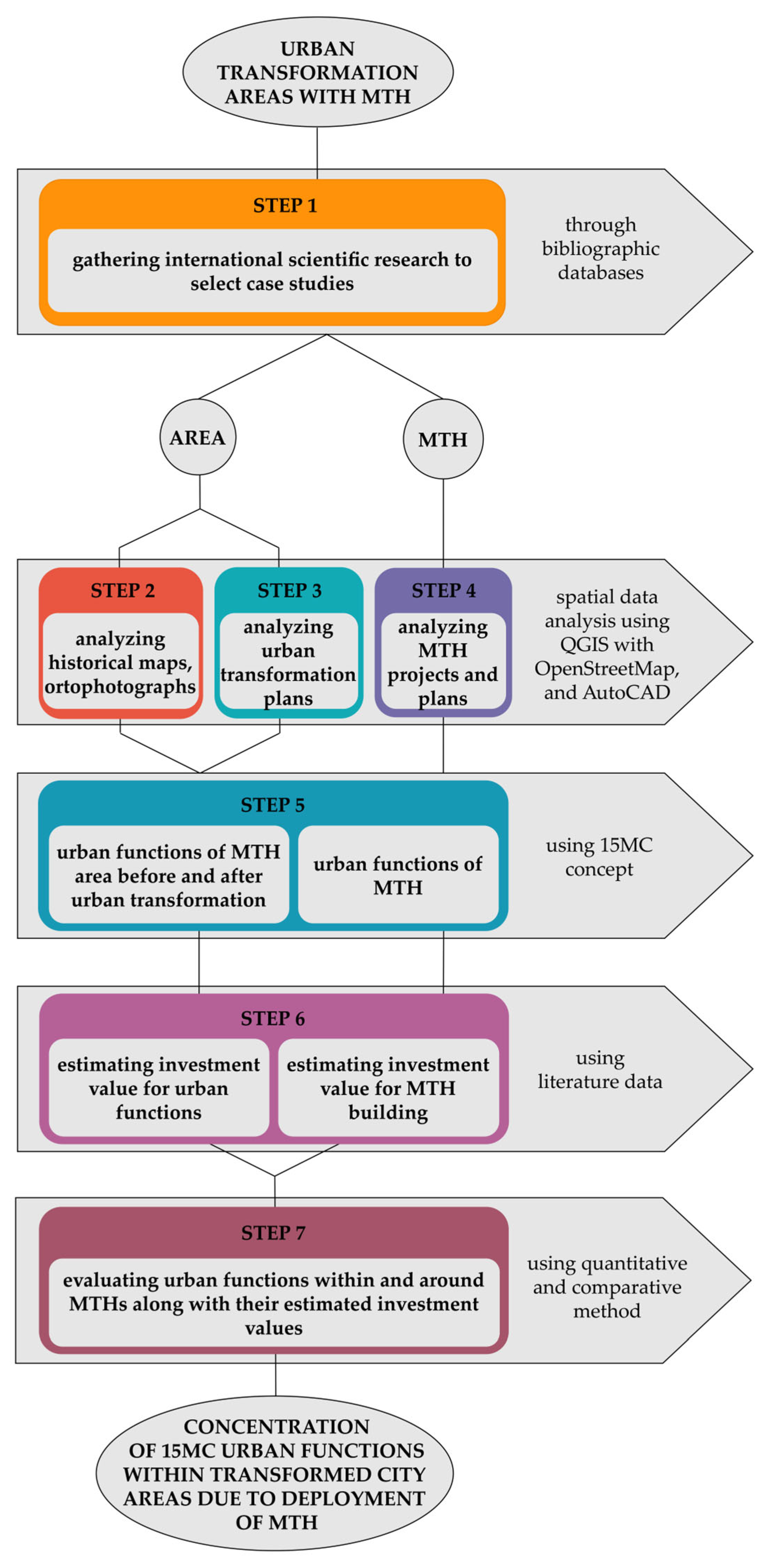
Figure 1. Research diagram. Created by the author (L.A.).
Urbansci 09 00327 g001
Figure 2. The position of La Sagrera Station area (marked by the orange line) within the city of Barcelona, based on a photo by Google Earth.
Urbansci 09 00327 g002
Figure 3. 15MC urban functions within the La Sagrera Station area: (a) before urban transformation (around 1990) and (b) after urban transformation (still in progress, construction works on the MTH expected to be finished in 2026). Figure created by the author (L.A.).
Urbansci 09 00327 g003
Figure 4. 15MC urban functions within La Sagrera Station. Figure created by the author (L.A.).
Urbansci 09 00327 g004
Figure 5. Central Station area position (marked by the orange line) within the city of Berlin, based on a photo by Google Earth.
Urbansci 09 00327 g005
Figure 6. 15MC urban functions within Europacity: (a) before urban transformation (1940) and (b) after urban transformation (2025). Figure created by the author (L.A.).
Urbansci 09 00327 g006
Figure 7. 15MC urban functions within Berlin Central Station. Figure created by the author (L.A.).
Urbansci 09 00327 g007
Figure 8. King’s Cross Station area position (marked by the orange line) within the city of London, based on a photo by Google Earth.
Urbansci 09 00327 g008
Figure 9. 15MC urban functions within the King’s Cross area: (a) before urban transformation (1999) and (b) after urban transformation (2025). Figure created by the author (L.A.).
Urbansci 09 00327 g009
Figure 10. 15MC urban functions within King’s Cross Station. Figure created by the author (L.A.).
Urbansci 09 00327 g010
Figure 11. The relation between urban functions within urban transformation areas (Stacked Column charts before, on the left, and after the urban transformation, on the right). Figure created by the author (L.A.).
Urbansci 09 00327 g011
Figure 12. The relation between 15MC urban functions and infrastructure areas within observed MTHs. Figure created by the author (L.A.).
Urbansci 09 00327 g012
Figure 13. The relation between 15 MC urban functions within observed MTHs. Figure created by the author (L.A.).
Urbansci 09 00327 g013
Figure 14. The relation between 15MC urban functions, MTH, and infrastructure areas within observed urban transformation areas. Figure created by the author (L.A.).
Urbansci 09 00327 g014
Figure 15. The relation between estimated investment values for urban functions and the MTH building. Figure created by the author (L.A.).
Urbansci 09 00327 g015
Table 1. 15MC urban functions before and after urban transformation. Created by the author (L.A.).
15MC Urban Function *La Sagrera Station Area, Barcelona (AR = 160 ha)Europacity,
Berlin (AR = 60 ha)
King’s Cross Station Area, London (AR = 34 ha)
BeforeAfterBeforeAfterBeforeAfter
Living (ha)6.4014.190.005.390.003.34
Working (ha)20.472.366.914.348.794.84
Commerce (ha)0.008.820.004.340.101.18
Healthcare (ha)0.000.630.000.000.000.00
Education (ha)0.006.992.281.980.002.29
Entertainment (ha)0.0063.720.006.180.004.93
* All the data presented in this table were obtained using the author’s drawings prepared in QGIS. Therefore, minor deviations from the actual areas are possible.
Table 2. 15MC urban functions within MTHs. Created by the author (L.A.).
15MC Urban Function *La Sagrera Station,
Barcelona (AR = 28.89 ha)
Central Station,
Berlin (AR = 6.50 ha)
King’s Cross Station,
London (AR = 4.78 ha)
Living (ha)0.000.000.00
Working (ha)0.001.100.00
Commerce (ha)0.950.580.71
Healthcare (ha)0.000.020.00
Education (ha)0.130.000.00
Entertainment (ha)6.19 **0.010.00
* All the data presented in the table were obtained using the author’s drawings prepared in AutoCAD. Therefore, minor deviations from the actual areas are possible. ** The data presented in the table refers to the area of the city park that extends over the MTH rooftop, but it’s not included in the overall area of the MTH
Table 3. Estimated investment value for all construction works within the urban transformation areas. Created by the author (L.A.).
CityYear of CompletionUrban Transformation AreaTotal Gross Area Within the Urban Transformation Area (GFA) *Total Estimated Value for Construction of BuildingsEstimated Investment Value Per Square
Meter of GFA
Total Area Under
Public Open Spaces **
Total Estimated
Investment Value for Public Open Spaces
Estimated Investment Value Per Square
Meter of Public Open Space
Overall Estimated
Investment Value ***
Barcelona2029–2050160 ha942,935 m2EUR 1.46BEUR 1548128.56 haEUR 140.10MEUR 109.00EUR 1.60B
Berlin2010–202760 ha819,000 m2EUR 916.75MEUR 111994.45 haEUR 83.25MEUR 68.13EUR 1.00B
London2011–202534 ha713,090 m2EUR 2.74BEUR 384729.74 haEUR 56.73MEUR 190.75EUR 2.80B
* The data presented in this column does not include the area of the MTH building. ** The data presented in this column were obtained using the author’s drawings prepared in QGIS. This includes areas that are on Figure 3, Figure 6, and Figure 9, identified as Entertainment and Infrastructure areas. *** The data presented in this column does not include the estimated value of construction works on the MTH buildings.
Table 4. Estimated investment values for construction works on MTH buildings. Created by the author (L.A.).
CityYears of ConstructionThe Total Gross Area of the MTH Building (GFA) *Total Estimated Investment ValueEstimated Investment Value Per Square Meter of the MTH Building
Barcelona2010–202628.89 haEUR 650MEUR 2249
Berlin1995–20066.50 haEUR 700MEUR 10,769
London2007–20124.78 haEUR 630MEUR 13,179
* The data presented in this column were obtained using the author’s drawings prepared in AutoCad 2026.
Disclaimer/Publisher’s Note: The statements, opinions and data contained in all publications are solely those of the individual author(s) and contributor(s) and not of MDPI and/or the editor(s). MDPI and/or the editor(s) disclaim responsibility for any injury to people or property resulting from any ideas, methods, instructions or products referred to in the content.