1. Introduction
As the concept of green mobility becomes more and more entrenched around the world, cycling continues to grow in importance as a green, low-carbon, and health-friendly mode of transportation. With the acceleration of urbanization, traffic congestion, environmental pollution, and other urban problems are becoming more and more serious. Cycling has shown remarkable value in easing traffic pressure, reducing carbon emissions, and improving the urban ecological environment.
Hengqin Island in Zhuhai is committed to building a high-quality living environment, and its cycling system, as a key component of the urban living environment, clearly adhered to the concept of “people-centered” in its infrastructure planning, with the aim of establishing a safe and convenient transportation system for walking and cycling. Continuous promotion occurred at the policy and practice levels: for example, in 2021, 130 electronically fenced bicycle service stations and 2000 shared bicycles were introduced. By 2022, the number of electronically fenced stations had grown to 200, and the “City Bicycle + Shared Bicycle” cooperative operation model was launched. By 2024, the number of shared bicycles exceeded 5000, and policies such as the “Measures for the Administration of Internet Leased Bicycles in the Hengqin Guangdong-Macau Cooperation Zone” were introduced. Measures and other policies were introduced to encourage residents and tourists to explore the island by bicycle. A well-developed cycling system not only helps to improve the quality of life of residents, but also enhances the attractiveness of a city. However, despite the fact that the cycling system on Hengqin Island has begun to take shape, there are still obvious shortcomings in terms of environmental comfort, information guidance, and facilities and services, which urgently need to be systematically optimized and upgraded.
The study is guided by habitat theory, focusing on the cycling system of Hengqin Island. At the theoretical level, the study expands the scope of application of habitat theory in the field of cycling systems, providing a new analytical perspective and methodological support for the field by integrating natural, humanistic, and social factors. The study is based on the “human–situation interaction” of habitat theory and focuses on the following three key interactions: first, energy metabolism, which refers to the physical energy consumption and adaptive adjustment of cyclists under the influence of climate and terrain; second, information perception, which refers to the spatial cognition of cyclists through physical markers and cultural symbols; and third, spatial–temporal adaptation, which refers to the dynamic match between cyclists’ behavior and the provision of facilities. Together, they constitute the core dimension of “human–environment” synergy in cycling systems, which is also the basis of the analytical framework of the study. On the practical level, the research results aim to provide a direct basis for the improvement and construction of the cycling system on Hengqin Island, which will effectively enhance the cycling experience and vitality, and, at the same time, provide a valuable practical model for the planning of cycling systems in other regions, especially in coastal cities.
2. Theoretical Foundations and Research Design
2.1. Theoretical Foundation and Domestic and International Research Progress
2.1.1. Habitat Theory
At the beginning of the twentieth century, many countries were at war [
1], and the idea of improving the human environment, which emerged at the end of the nineteenth century, was continued during this period, with the academic community thinking about urban planning [
2,
3,
4,
5,
6], ecology [
7,
8], and architecture at all levels. In the 1960s and 1970s, the rise of industrial civilization promoted the process of urbanization, but, at the same time, also brought about serious ecological and environmental problems. In 1962, Rachael Carson, with her book
The Silent Spring, alerted people to the possibility that the industrial revolution would bring about a crisis in the survival of mankind, and called on the general public to pay more attention to the relationship between human beings and nature [
9,
10]. McHarg proposed in 1969 that the scope of “planning” and “design” should be extended to include ecological science [
11]. The Science of Human Settlements, a theory proposed by Greek architect C.A. Doxiadis, takes all human settlements, including villages, towns, and cities, as the object of study, and emphasizes the analysis of the interrelationships between human beings and the environment [
12]. Since then, through a series of conferences, the focus on improving human settlements expanded from academia to world leadership and became a global program of construction. In China, in 1987, academician Wu Liangyong proposed An Integal Architecture, which expanded “architecture” to “settlement”, integrating architecture and the city, which is the prototype of the idea of habitat [
13]. At the beginning of the 21st century, UN-HABITAT published “Planning Sustainable Cities: A Global Report on Habitat”, in which it proposed five new challenges facing cities in the 21st century, promoting the process of theoretical research on the human habitat environment [
14]. Based on the “triad” in philosophical epistemology and methodology, Prof. Liu Binyi of Tongji University put forward the triad theory system of habitat, background–activity–construction, which laid the foundation for the subsequent creation of the theory of “human–environment interaction” [
15].
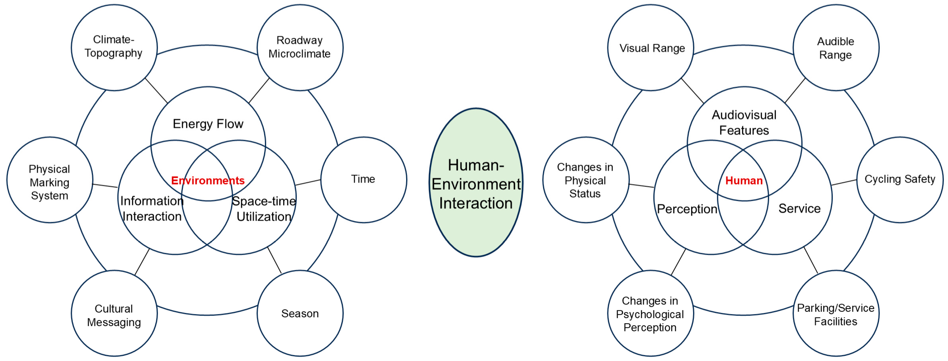
The study takes the mechanism of “human–environment interaction”, which is the core of the triad theory of the human habitat environment proposed by Liu Binyi, as its theoretical guiding framework [
15,
16,
17]. The theory emphasizes that the core of the habitat lies in the dynamic interaction process occurring between the subject (human) and the object (environment): taking human perception as the starting point, the energy flow, information interaction, and spatial and temporal utilization embedded in the environment are taken as the core elements of the “environment”, so as to form a bidirectional subject–object interaction relationship. In this context, the concept of environmental “place” can be quoted, as Christian Norberg-Schulz argues that for people to inhabit, orientation and identification with the environment is a necessary condition. Place focuses on experience, which is not limited to the boundaries of spatial geometry, but rather to the space in which people’s lives take place [
18]. Applying the mechanism of “human–environment interaction” to the study of cycling systems means focusing on the interaction between the cyclist (the subject) and the cycling environment (the object) in the dimension of the above core elements. Together, the above elements constitute the specific carrier of “human–environment interaction” in the cycling system, which corresponds to the three dimensions of energy flow, information interaction, and spatial and temporal utilization (
Figure 1).
2.1.2. Research Progress at Home and Abroad
With the elevated pressure imposed by the growth of motor vehicle ownership on the development of slow-moving urban systems, optimization research on slow-moving systems (especially cycling systems) has received attention from academics [
19,
20,
21,
22,
23,
24]. The system optimization of cycling as a green, low-carbon mode of travel is related to transport efficiency, but also affects the quality of human settlements and ecological sustainability [
25,
26]. Cycling can exert greater advantages than motorized vehicles, especially in urban environments [
27]. Currently, the cycling system in China’s southern coastal cities (e.g., Hengqin Island), with multi-dimensional value, is facing complex real-world challenges because of its climatic particularities (high temperature and high humidity) and spatial complexity (cross-border linkages). In the following, according to the logic of macro-assessment–meso-design–micro-interaction, a description is given considering the three aspects of the construction of an evaluation system–exploration of planning practice–research on behavioral mechanisms.
The construction of an evaluation system for cycling systems presents the characteristics of multi-dimensional expansion and refinement evolution. Scholars start from different levels such as infrastructure, spatial accessibility, environmental impact, safety, and security, and gradually form an indicator framework covering hardware performance and humanistic needs. JH Hwang et al. attempted to reconfigure areas that traditionally prioritize the use of automobiles from the perspectives of environment, safety, and accessibility, and used the impact of CO
2 emissions on the environment as an evaluation indicator [
28]. AM Castronovo et al. proposed a combined analysis of multiple factors (muscle fiber distribution, pedaling cadence, vehicle frame setup, environmental variables, psychological characteristics, etc.) from the perspective of human athletic performance as a way to more effectively improve cycling performance [
29]. T Götschi et al. evaluated cycling infrastructure safety facilities using video technology and pointed out that the marking of left-turning bike boxes improved the perceived safety of intersections [
30]. X Deng et al. focused on evaluating the user-friendliness of the cycling network and the day-to-day functioning of the cycling community, and proposed six quantitative metrics [
31]. MSN Niaki et al. considered discontinuity as an important indicator for cycling network assessment and proposed codes to measure cycling network connectivity [
32]. Li Congying et al. provided an overview of travel quality evaluation methods for urban cycling systems, covering the indicator system and model construction, and provided tools for quantitative assessment [
33]. Hongwei Xu constructed an evaluation system for the level of slow-moving transportation supply from a demand analysis of urban transportation systems and applied it to commercial streets under renovation [
34].
In terms of exploring planning practices, both international cases and domestic practices have accumulated experience. The design of Danish cycling facilities can be used as a foreign case study for reference, with its optimization of parking, guidance, intersections, etc. [
35], such as Copenhagen’s Traffiklegepladsen (Traffic Square), which is a kind of educational traffic park, and the setting of traffic signals. Governments’ interest in the bicycle as a process of improving the urban environment has contributed to its development in cities: people in Amsterdam and Copenhagen now use bicycles for about 40% of their trips [
36,
37]. The above achievements of Denmark and the Netherlands have made other cities realize the importance of bicycle development [
38]. Tsukuba, Japan, created a “Bicycle City” by designing a complete cycling network by region and functional system, integrating it with other public transportation to enhance vehicle parking management [
39]. Some scholars have proposed introducing artificial intelligence technology into signal control systems to avoid the unsafe hazards of slow-moving traffic at intersections and protect the safety of pedestrians and non-motorized vehicles [
40]. The Netherlands designates transportation policies flexibly formulated for the political system of each place, for example, Utrecht has implemented a “bicycle first” policy [
41]. Amsterdam restricts motorized vehicles from entering the city center and sets bicycle signals at some intersections to turn green earlier than motor vehicle signals. In domestic practice, Xiamen, facing the double pressure of scarce land resources and traffic congestion, built China’s first and the world’s longest aerial bikeway in 2017, integrating transportation, leisure, and sightseeing [
42]. However, although it has become a demonstration section, it has not yet formed a cycling network. Sun Ting et al. studied cycling strategy and planning design in the context of carbon neutrality based on the cycling system practices in four major international cities (Copenhagen, Paris, New York, and London) [
43].
In terms of behavioral mechanism research, scholars focus on the interaction between cyclists and the environment and analyze the logic of behavior from the micro level. Aamir Yousf calculated traffic flow speeds and densities by collecting the flow characteristics of each access system at their study site and made recommendations to improve the conflict between the area’s slow-moving system and vehicular traffic [
44]. Regarding the construction of cyclists’ self-identity, Zheng et al. analyzed the reconstruction of cyclists’ identity and spatial “neighborhood” from a sociological perspective, guided by structuration theory [
45]. The frequency of cyclists’ interaction with the environment will be enhanced by increasing the stimulation of individual senses during cycling. The visual environment of a countryside greenway has an influential mechanism on cycling stopping behavior, and the visibility of the landscape can be appropriately enhanced at nodes with a poor visual environment so as to prolong stopping time [
46]. Differences in travel times and trip purposes, such as the weekday double morning peak and the three categories of commuting, household chores, and recreation, can have an impact on riding behavior patterns and the corresponding built environment [
47,
48,
49].
In summary, although the current research on cycling systems covers the dimensions of evaluation, planning, and behavior, there are obvious limitations: firstly, there is a lack of systematic integration of “natural environment–humanistic information–social behavior”, and secondly, the theory of “human–environment interaction” has not yet been utilized to analyze the dynamic synergistic relationship between ‘human’ and “environment” in cycling systems. This limitation is particularly prominent in cycling systems in hot and humid coastal cities (e.g., Hengqin Island), providing room for innovation in research.
2.2. Research Purpose
The study aims to achieve the following core objectives: first, to expand the application boundaries of habitat theory in cycling system research; second, to apply the research strategy of “system-wide coverage + weak point entry”, focusing on the systematic shortcomings and explanation of the functioning mechanism of non-popular paths such as the North Roundabout Road, and providing a theoretical basis for optimization strategies. Third, based on the path evaluation and shortcoming mechanism analysis, the research chain of “theoretical modeling–problem diagnosis–optimization strategy” is formed to form an optimization paradigm for non-popular road sections oriented by the synergy of human settlements, which will provide practical references for the planning of slow-moving traffic systems from the Guangdong–Hong Kong–Macao Greater Bay Area to coastal cities.
2.3. Research Methods and Route Selection
Based on the aforementioned theoretical framework and research objectives, this study focuses on the following core research questions:
From the dimension of energy flow, how do the climatic characteristics and topographical differences of Hengqin Island specifically affect cyclists’ energy consumption and cycling experience? What are the key mechanisms of “human–environment” interaction?
From the dimension of information interaction, how do the disconnection of a physical marking system and the transmission of cultural information affect the spatial cognition and path choices of cyclists? What is the mechanism of their coupled influence on cycling experience?
What are the differences in cycling behavior at different times of the day in terms of spatial and temporal utilization dimensions? Does the existing supply of cycling facilities match these dynamic demands?
The above issues constitute the focus of this study, and the subsequent data collection and analysis methods will focus on these issues in order to systematically analyze the mechanism of “human–environment interaction” and the optimization path of the cycling system on Hengqin Island.
2.3.1. Research Methods
A qualitative and semi-quantitative analysis of the energy environment (climate and terrain) and spatial layout (road section and distribution of facilities) of the cycling routes around the island was carried out through field cycling inspections and the use of the environmental behavior recording method. Among them, the qualitative analysis of the energy environment focused on core somatosensory features, including skin stickiness triggered by high temperature and humidity in summer, resistance when riding against the wind, and the feeling of the body’s muscles on uphill and downhill sections, with specific scenario differences documented through text. The semi-quantitative analysis was based on the existing data processing, combined with the cycling track tracking data in the two-step software to record the cycling speed and elevation of each section of the road, and, at the same time, the ERA5 reanalysis dataset was relied on (
https://cds.climate.copernicus.eu/datasets/reanalysis-era5-land?tab=overview (accessed on 6 August 2025), ERA5 integrates the global ground weather stations, soundings, satellites, and other sources of observations, and is generated by the European Center for Medium-Range Weather Forecasting (ECMWF)). The error level of ERA5 has been validated by a large number of studies and is more reliable for trend analysis in this study [
50]. The study used Hengqin Town (22.11° N 113.57° E) in Zhuhai as the climate region and a time range from 1 March 2024 to 2 March 2025, the date of the cycling research, to summarize data on total precipitation, sunshine hours, total short-wave radiation, 2 m average air temperature, relative humidity, and 10 m average wind speed and to analyze the effect of climatic characteristics on cycling pace. The qualitative analysis of the spatial layout elements focused on describing the spatial characteristics of the system, including the functional types of road, such as mixed-motorized and non-motorized sections and independent non-motorized lanes, and the completeness of the facilities, such as the lack of guiding signage and the degree of ground intactness, which were supported by on-site recordings and photographs. The semi-quantitative analysis was performed by counting the number of resting points, signage, and distribution of the routes, and, at the same time, documenting the existence of the road separator zones.
- 2.
Behavioral Observation Method.
A phenomenological recording method was used to capture the rider’s immediate perceptions of each section of the trail through a systematic individual cycling log, focusing on the perception of upwind resistance, the clarity and absence of the guidance signage system, and the perception of safety during the ride. In order to ensure the validity and reliability of the methodology, the research system recorded fields such as “location of road section, time, weather, core experience, and specific description” to minimize the arbitrariness of the records, and compared the records of individual experiences with the objective data of the field survey. It should be noted that from the perspective of ethical norms, this study is based on the researcher’s own field riding research, with no external participants, so there is no third-party informed consent and confidentiality required; the riding process strictly adheres to traffic rules, avoiding bad weather and high-risk road sections, to ensure safety; the raw data only records the characteristics of road sections and the content of the experience, and does not contain any personal identification information. Hengqin Island, as a typical coastal city in the Guangdong–Hong Kong–Macao Greater Bay Area, is representative of its climatic characteristics and spatial structure, and the findings of the study will serve as a reference for similar cities in terms of “types of problems” (e.g., microclimate regulation, optimization of signage systems, etc.), which need to be adapted and applied to the local reality.
2.3.2. Data Sources and Collection
Hengqin Island is located in the south of Zhuhai City, Guangdong Province, on the west bank of the Pearl River Estuary, adjacent to Macao, China, with a total area of about 106 square kilometers, and is the intersection of “one country, two systems” and the core node of the Guangdong–Hong Kong–Macao Greater Bay Area, with an outstanding strategic position. The island has convenient transportation, relying on the Hong Kong–Zhuhai–Macao Bridge, Hengqin Second Bridge, and other hubs, forming a “1 h transportation circle” with Hong Kong, Macao, and the main city of Zhuhai. The spatial planning adopts the structure of “one center, two belts, three pieces, and multiple clusters”, linking the urban vitality belt of Tianmu River and the ecological landscape belt of Mangzhou Wetland, with a resident population of about 49,100 in 2024 (Source: Statistics Bureau of the Executive Committee of the Cooperation Zone), projected to increase to 200,000–250,000 in 2035, with a focus on attracting Macao residents and international talent.
The island has formed a “three horizontal and five vertical” trunk road network, with a 95% public transportation coverage rate. As an important extension of the slow-moving system, although about 70 km of greenways has been built, there are still problems such as network breaks and insufficient supporting facilities. Therefore, it is necessary to optimize the cycling system of Hengqin Island to improve the closed loop of the slow-moving system, the coverage of facilities, and the cycling experience.
2.3.3. Route Selection
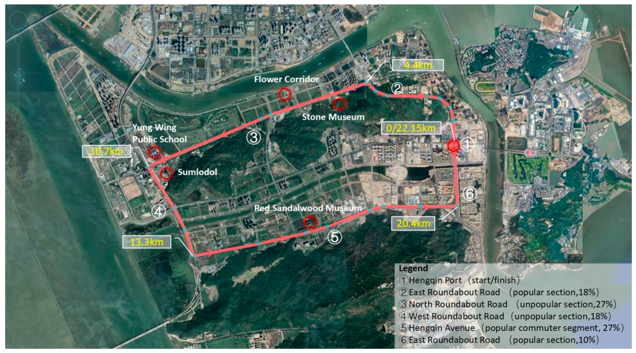
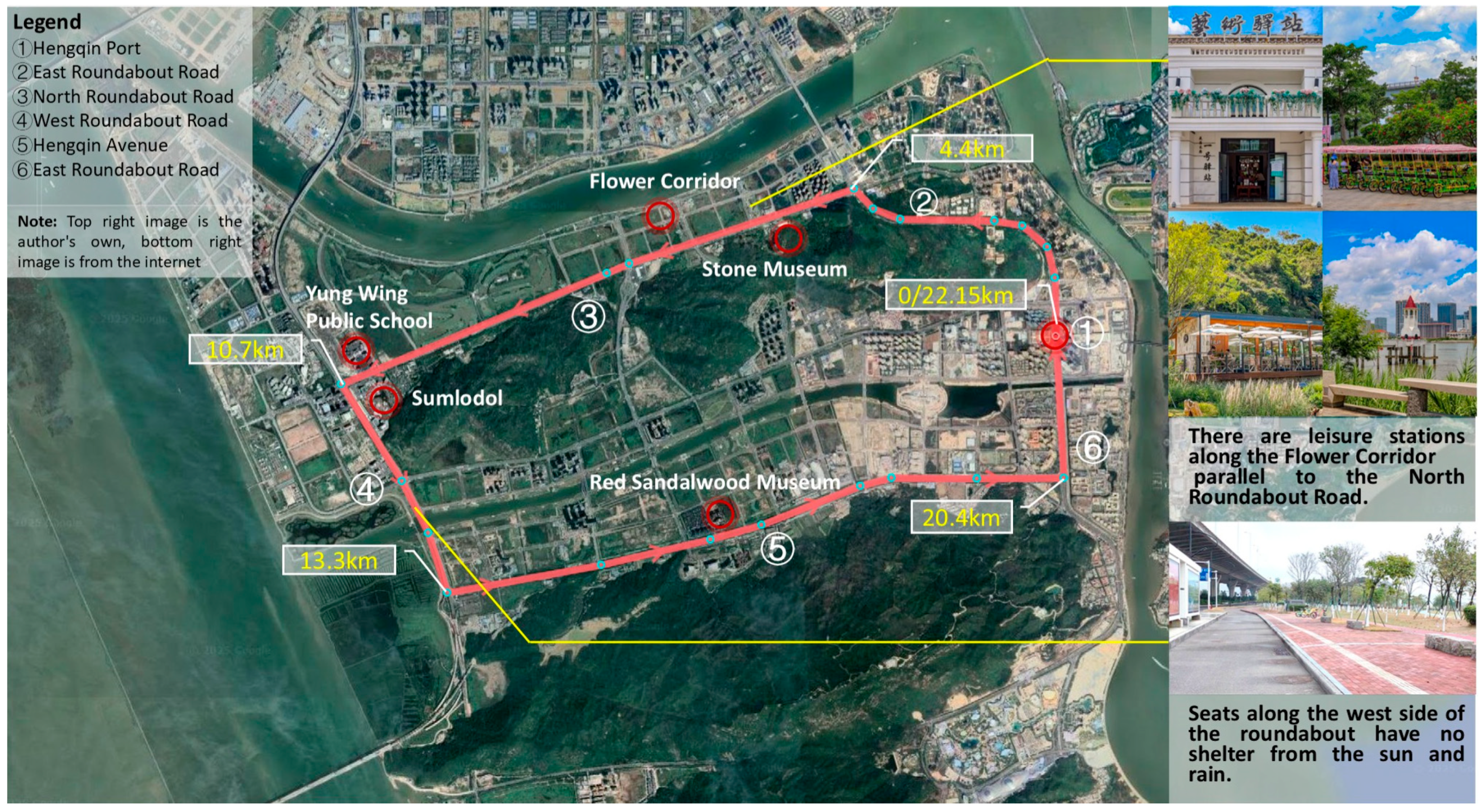
The specific directions and percentages of the loop are Hengqin Port–East Roundabout Road (popular section, 18%)–North Roundabout Road (non-popular parallel section, 27%)–West Roundabout Road (non-popular parallel section, 18%)–Hengqin Avenue (popular commuter section, 27%)–East Roundabout Road (popular section, 10%)–Hengqin Port (
Figure 2). The choice of North Roundabout Road as the core analysis section is mainly based on its representativeness as a parallel alternative path to the popular section Flower Sea Promenade (500 m apart). The three-dimensional analysis framework of habitat theory is as follows:
Focusing on the problem of insufficient vegetation shade in this road section, public data from the Meteorological Office and individual cycling sensory records are integrated to build an environmental assessment system of “data + cognition”.
- 2.
Information Interaction Dimension.
The current status of cultural signage installation on road sections is systematically recorded and the mechanism of information disconnection on cycling experience is analyzed.
- 3.
Space–Time Utilization Dimension.
The influence of different times of day (commuting/leisure) and seasonal factors on cycling behavioral characteristics is explored, and the distribution of supply facilities along the route is assessed.
3. Habitat Theory-Based Three-Dimensional Analysis Model for Cycling Systems
The cycling loop mainly relies on urban roads and traverses functional areas such as residential, commercial, and tourist areas. The study focuses on the three-dimensional characterization of the ring road’s energy environment (climate/terrain), information environment (human markers), and space–time environment (temporal characteristics).
3.1. Energy Flow Dimension
3.1.1. Mechanisms of Climate–Topography Energy Metabolism
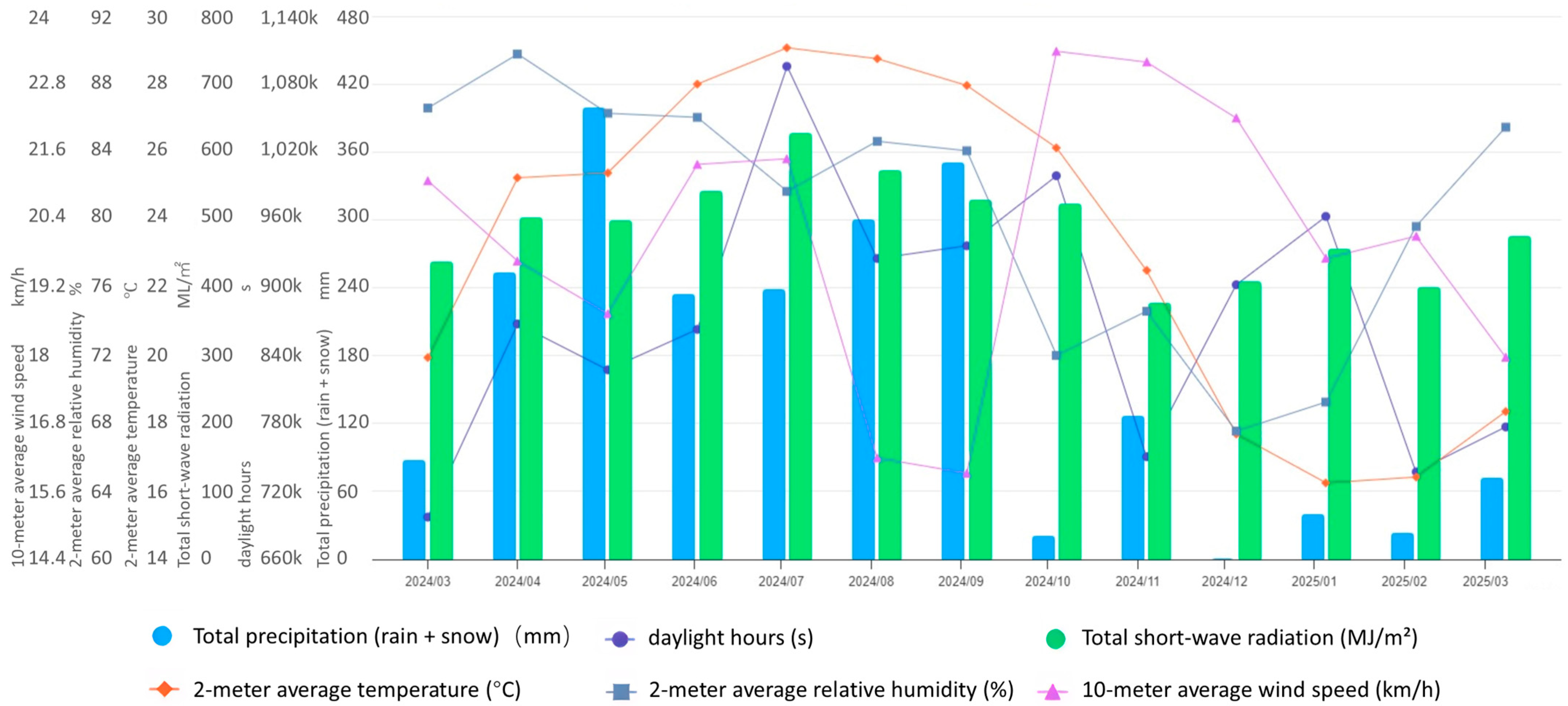
Hengqin Island has a typical southern coastal climate, with mild winters and significant hot and humid summers. Meteorological data from March 2024 to March 2025 (source: CMA) show that the annual sunshine hours amount to 3151 h (the average daily > in July is 10 h) and the peak shortwave radiation in July is 627.83 MJ/m
2. Precipitation is concentrated from April to September (>164.8 mm monthly average), and winter is scarce. The average temperature of 2 m in April and October > the annual average value (23.21 °C), reaching 29.07 °C in July, the annual average value of relative humidity > from March to September (80.58%), and the constant ≥ in March–June and August–September is 86%. The 10 m wind speed from February to March, June to July, and October to December > average annual (20.08 km/h), is low (about 16 km/h) from August to September, and the dominant wind direction is northeast to south (
Figure 3).
A comprehensive analysis shows that the core climate parameters exceed average values for about seven months of the year. In summer, a high temperature and high humidity combined with a low wind speed severely inhibit sweat evaporation and heat dissipation, resulting in a higher body temperature (heat stress accumulation), increased fatigue, and increased physical exertion. In winter and spring, the temperature and humidity are suitable and the wind speed is high, which is conducive to heat dissipation, improving cycling efficiency, but the upwind sections (e.g., West Roundabout Road and Hengqin Avenue) still face additional wind resistance energy consumption, and the coastal vegetation has a certain buffering effect on the wind sensation.
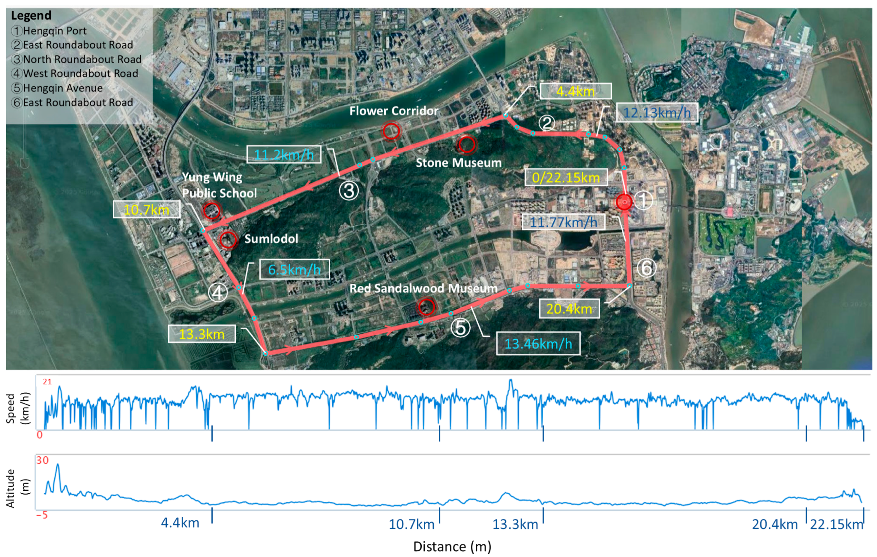
The terrain is generally flat and conducive to cycling, but there are local elevation changes: the east road around the island is slightly uphill (up to 4.44 m), the west road around the island (near the west gate of the Tianmu River) is obviously uphill (up to 5.54 m), and the rest of the road undulates less than 3 m. The cycling pace data shows that the speed along West Roundabout Road (about 6.5 km/h) and East Roundabout Road is significantly lower than that of flat road sections (about 10 km/h) due to the influence of slope resistance, which clearly reveals that the terrain elevation change restricts energy utilization efficiency by increasing resistance, highlighting the key role of flat terrain in maintaining efficient cycling (
Figure 4).
3.1.2. Microclimate Energy Conflict in Road Sections
Different sections of the region produce different microclimate energies, which are influenced by temperature and humidity, wind speed, vegetation on both sides of the road, and road width. The following analysis is based on the 2 m temperature and relative humidity and 10 m wind speed data at 8 a.m. and 11 a.m. on 2 March 2025, the date of the cycling study (data from ERA5 reanalysis dataset [
51]).
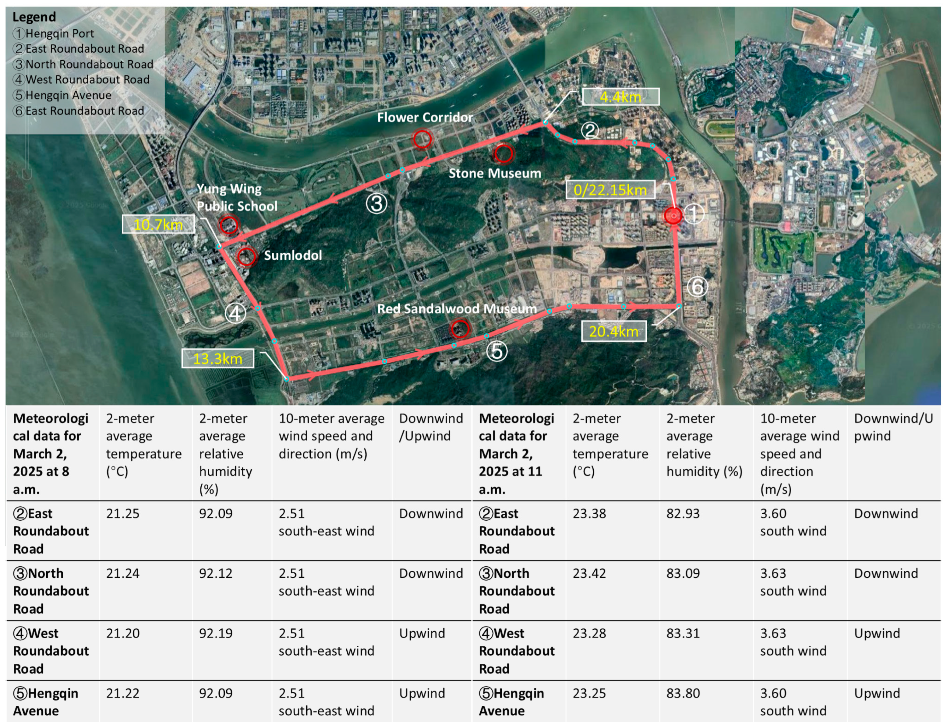
At 8 a.m., the average air temperature value in each road section is about 21.2 °C. Among them, the temperature at North Roundabout Road and Hengqin Avenue near Hengqin Port is about 0.2 °C higher than that in the middle of the road section; the temperature at West Roundabout Road near Tianmu River is about 0.3 °C lower than that in the middle of the island, but the relative humidity is correspondingly 0.1% higher. Hengqin Avenue has the lowest relative humidity (92.09%) because it is adjacent to the Great Hengqin Mountain in the south and far away from water bodies on three sides. The National Oceanic and Atmospheric Administration (NOAA) Heat Index indicates that above a given temperature threshold, an increase in relative humidity at the same temperature will significantly exacerbate perceived body temperature. By 11:00 a.m., the daytime 10 m wind direction shifts from southeast to south, with an increase in wind speed of about 1.1 m/s. East Roundabout Road and North Roundabout Road form a downwind section (lowering the energy consumption of the human body), while West Roundabout Road and Hengqin Avenue are upwind sections (
Figure 5).
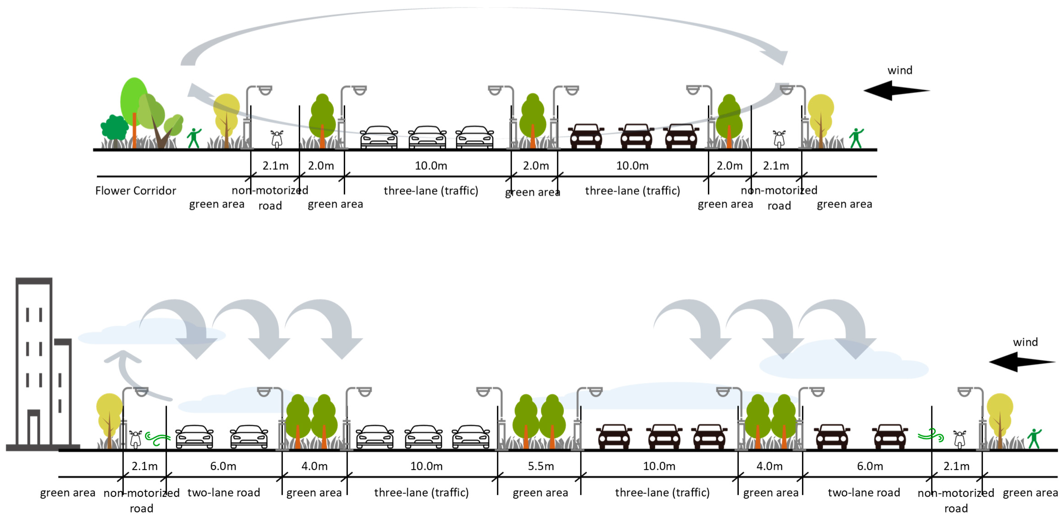
The road cross-section structure has a key influence on the microclimate. Hengqin Avenue has the widest road surface and is densely populated, with high-rise buildings on the north side. Despite the influence of southerly winds, airflow is blocked by the wide road width and building obstructions, creating a significant urban canyon effect, which, together with the thermal emissions from motor vehicles, contributes to hot air and increased cycling fatigue. In contrast, North Roundabout Road and West Roundabout Road are separated by a central green belt, and the sideways direction is unobstructed, which is conducive to southeast/south winds effectively dissipating the radiant heat of sunshine and exhaust fumes, so the microclimate environment is relatively optimized (
Figure 6). However, the overall vegetation shade of the loop is low, reducing riding comfort, and the pavement is predominantly light-colored asphalt (about 20–30% reflectivity). The spring morning sun altitude angle is low, the sunlight through the light-colored road surface is nearly specular reflection, and the riding line of sight (about 1.2–1.5 m height) forms a direct angle, such as that encountered superimposed on the surrounding buildings’ glass curtain wall with secondary reflection (such as Hengqin Port, Hengqin Avenue, near the high-rise buildings), resulting in a sharp decline in the visual comfort of the rider, the phenomenon of glare, and blurring of the eyes. This glare can trigger transient visual fatigue (manifested as dry eyes, tearing, and early onset of physical fatigue in the rider). In addition, although downwind sections can enhance riding efficiency through airflow, glare can also lead to distraction and exacerbate conflicting microclimatic energies. In essence, the low vegetation shade rate leads to the road energy (solar radiation) not being effectively dissipated through the “vegetation transpiration–shade” link, but through the reflection into the “visual energy interference”, and the temperature, humidity, wind speed, and other energy fields are superimposed, forming a “thermal environment–light environment–experience feeling” multi-dimensional conflict.
In summary, Hengqin Avenue is susceptible to cycling fatigue due to the excessive width of the roadway and the obstruction of high-rise buildings on the north side, where airflow is blocked to create localized heat buildup. Although its relative humidity is not the highest along the whole route, its topography away from water bodies weakens the local cooling potential. In contrast, the microclimate of North and West Roundabout Roads is relatively better in terms of thermal comfort by virtue of the green belt separation and lateral open layout, the phenomenon of southeasterly or southerly winds effectively dissipating heat, and less interference from exhaust fumes.
3.2. Information Interaction Dimension: Human–Physical Perception Network Construction
3.2.1. Perceived Breakdown of Physical Signage Systems
As the core medium of slow-moving transportation spatial cognition, the completeness and accuracy of the physical signage system are crucial to public travel efficiency and experience. Field research shows that the physical signage system of the cycling loop on Hengqin Island is significantly broken, especially regarding the ambiguity of the guidance on the North Roundabout Road. Specifically, there is a lack of clear parking guidelines for shared bicycles in the Hengqin Port area, forcing first-time users to navigate to the station square to find a bicycle; at the key node where East Roundabout Road turns into North Roundabout Road, the lack of signs causes cyclists to rely on navigational software to identify their direction; and North Roundabout Road, which runs parallel to the popular attraction of the Flower Corridor, lacks associated signs, missing a good opportunity to guide recreational cycling and become part of the mixed roadway. In addition, some mixed-access road sections (non-motorized/motorized vehicles and non-motorized vehicles/sidewalks) lack clear right-of-way attributes at the entrances (
Figure 7).
The lack of signage and ambiguity of guidance (including parking guidance, key turning, attraction association, and right-of-way information) seriously interfere with the spatial cognition and path decision making of cyclists, which not only reduces travel efficiency, but also induces traffic order chaos and safety hazards. Therefore, the construction of a continuous and clear physical signage system is an urgent need to enhance the efficiency of slow-moving transportation services and optimize the public travel experience.
3.2.2. Fault Lines in the Transmission of Cultural Information
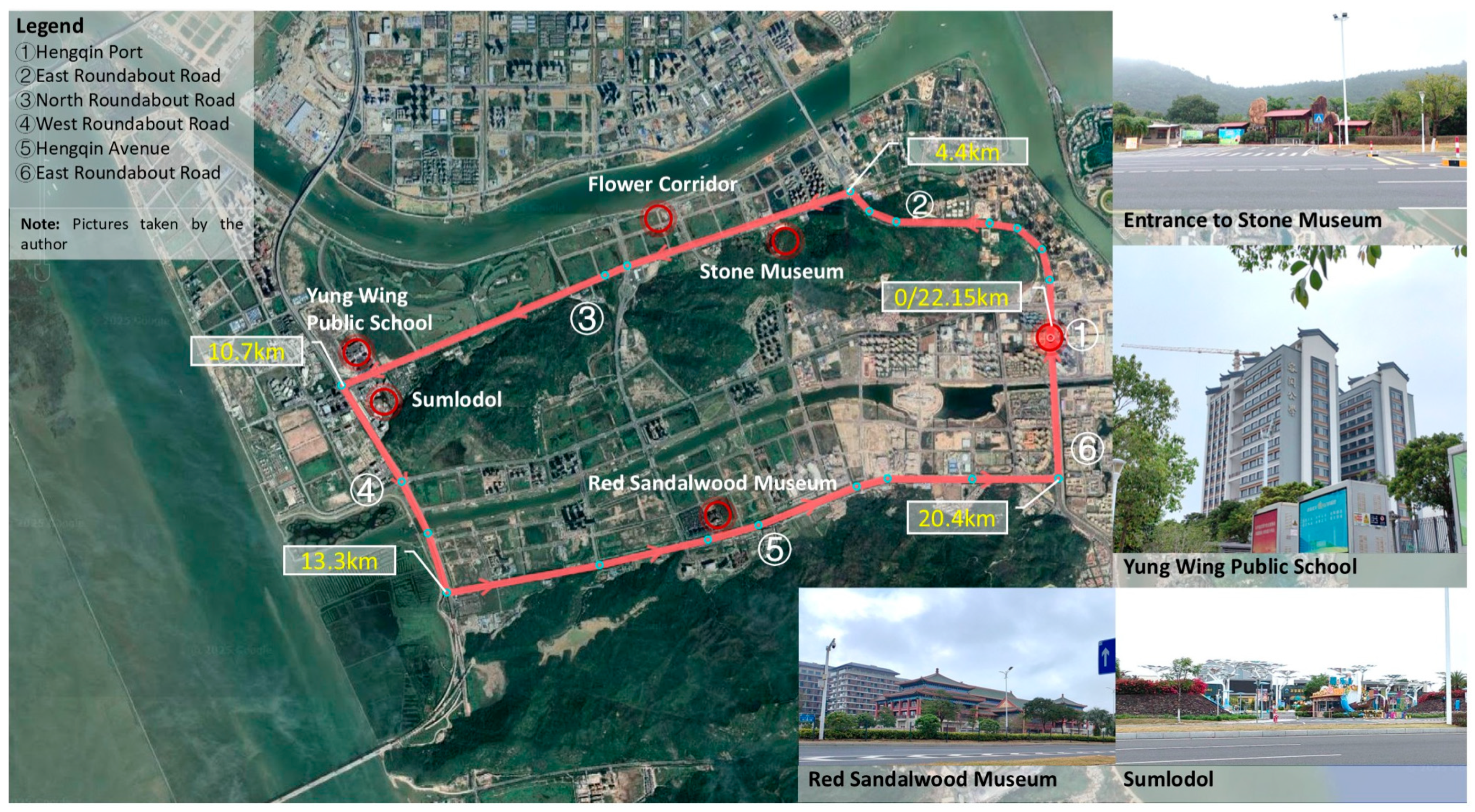
There is a double fault line in the transmission of cultural information. First, the interpretation of cultural nodes is weak. Although the cycling route passes through representative places such as Stone Museum and Yung Wing Public School on North Roundabout Road, Sumlodol on West Roundabout Road, and Red Sandalwood Museum on Hengqin Avenue, there is a general lack of signs or publicity media to explain the cultural connotations of these places, which makes it difficult for cyclists to form effective cultural cognition, and their willingness to stay is low (
Figure 8). Second, the density of social activities is low. Except for the Hengqin port area, there are few traces of pedestrian activities along the ring road, making it difficult to capture the local flavor of life. This low-popularity environment objectively prolongs cyclists’ psychological perception of the journey. In addition, the soundscape characteristics show significant road segment differences: in the North/West Roundabout Road segment, where there are few pedestrians and vehicles, wind and birdsong constitute the main sound sources, while in the Hengqin Avenue segment, where there is no green isolation zone, the noise of motor vehicles becomes the dominant auditory interference.
In summary, in the energy flow dimension, the climate shows significant seasonal cycle characteristics: summer (June–September) is characterized by strong humidity and heat (average temperature of 28.1–29.07 °C, humidity greater than 85%), lasting more than 120 days, which is longer than that of Xiamen in the same climatic zone (about 20 days more), and the ratio of extreme hot and humid days (temperature greater than or equal to 28 °C + humidity greater than or equal to 85%) reaches 75%, which is significantly higher than neighboring cities. Winter (December–February), on the other hand, is characterized by mildness and stability (15.3–18.2 °C, 72–78% humidity), with temperature fluctuations of only 1.5 °C. This cycling directly affects riding efficiency through energy metabolism—hot and humid summers exacerbate physical exertion, and mild winters enhance riding comfort. This cyclic feature provides a case study reference for the design of cycling systems in hot and humid coastal climatic zones, while differentiated adaptation in different climatic zones can be further deepened in subsequent studies. Also, smaller differences in elevation can directly affect riding pace. Hengqin Avenue has a heat island effect due to its spatial pattern and pollution, while the North/West Roundabout Roads optimize the microclimate by virtue of the greening layout. In the information dimension, the disconnection of physical signage (lack of parking guidelines and ambiguity in steering) and insufficient cultural interpretation (lack of attraction connotation and sparse social activities), together, lead to a disconnection in the transmission of information. This double bottleneck constitutes a core obstacle to the systematic optimization of the cycling experience.
3.3. Spatio-Temporal Utilization Dimensions: Behavioral Adaptation Under Time-of-Day and Seasonal Differences
Cycling behavior around Hengqin Island shows significant time and seasonal differences, which profoundly affect the experience and demand of cyclists. In terms of the time dimension, weekday mornings and evenings (7–9 am and 5–7 pm) are the peak periods for commuting, focusing on the Hengqin Port, East Roundabout Road, and Hengqin Avenue, where riders have higher demands for road smoothness and signage clarity. During non-commuting hours, especially during the daytime on weekends and holidays (10 am–4 pm), the demand for leisure cycling rises, and cyclists are more concerned about the landscape along the road, their cycling experience, and places for rest and exchange. Field research found that although the Flower Corridor, Stone Museum, and other attractions attract leisure crowds, supporting facilities such as sun shading seats, riding stations, parking points, and cultural introduction signs are generally missing, making it difficult to meet this demand. In the evening (after 20:00), the number of cyclists is low, but the lack of lighting and unclear signs on the West Roundabout Road and other sections of the road pose a safety hazard to fitness enthusiasts or travelers who need to ride at night.
Seasonal fluctuations also significantly affect riding behavior. In the spring, the weather is pleasant and the willingness to ride is high, and the tandem effect of the attractions on North/West Roundabout Road enhances use of the road sections. Summer is hot and humid with lots of rain, which limits cycling activities, except in the early morning and evening, and the accessibility of recreational facilities along the road needs to be optimized. Autumn is the golden period for cycling activities. Family activities and races are mostly routed along the loop and Flower Corridor. In winter, Hengqin Island has a unique floral landscape, attracting residents of Qin’ao and Zhuhai to experience the Flower Corridor and Wetland Park.
3.4. Cyclist Subject Experience and Three-Dimensional Interaction
3.4.1. Static and Dynamic Switching
There is a significant difference between cyclists’ experiences during dynamic riding and static stopping. When riding dynamically, cyclists perceive the wind effect brought by speed, and along with a faster riding speed, their physiological state is characterized by an increased heart rate (up to 130 beats/min), accelerated respiration (20–30 beats/min), leg muscle strength, and increased body temperature, and their psychological state is characterized by excitement and vitality. In this state, the cyclist is highly sensitive to the dynamic changes of surrounding fast transportation (e.g., electric vehicles and motor vehicles), and the need for cycling safety is particularly prominent. After switching to a static stop, the body gradually smooths out from a tense state, the perception of the environment increases, and riders have an urgent need for surrounding scenery in order to effectively soothe the body and mind. After resting for about 15 min, the heart rate drops to 70–90 beats per minute, the body relaxes, muscle pain is relieved, and the psychological state tends to be calm and pleasant. At this time, the riders’ demand for energy replenishment places increases significantly (
Table 1).
3.4.2. Audiovisual Features
The measured cycling speed characteristics of this study show that less efficient sections such as the West Roundabout Road reach about 6.5 km/h and flat efficient sections reach about 10 km/h. This natural divergence shows that 8 km/h is in the middle of the two types of roadway speeds: less than or equal to 8 km/h is defined as low-speed riding (including stops), when the riding state is accompanied by terrain resistance, the rider needs to continue to exert force, and it is easier to pay attention to the distribution of physical force rather than environmental details; more than 8 km/h is defined as high-speed riding, when the rider can maintain an efficient rhythm due to weak terrain resistance and attention is more focused on smoothness. In this way, the difference between audiovisual experiences during high- and low-speed riding is clearly differentiated.
A cyclist’s audio–visual perception and physical and mental states change dynamically with the cycling conditions and environment. In terms of vision, when cyclists look straight ahead, movements within a horizontal viewing angle of about 180° (90° unilaterally) can be included in the field of view, but cycling speed significantly affects visual efficacy [
1] (pp. 69–70). In low-speed riding or stopping states, visual resolution is high, and the details of the surrounding scenery can be recognized; when riding at a high speed (e.g., the section of Hengqin Avenue), although the width of the field of view increases, dynamic visual sensitivity decreases, it is difficult to recognize details, and the landscape presents transient blurring characteristics (
Table 2).
In terms of hearing, the effective hearing range of cyclists is about 7 m, and perception is sharply reduced beyond 25 m [
1] (p. 69). At low speeds or in a stopping state, the sound of gentle wind, wheel friction, breathing, and environmental sounds (e.g., insect chirps and bird calls) can be clearly perceived; when riding at high speeds, the whistling sound produced by the somatosensory wind effect hides environmental nuances, with motorized vehicle noise becoming the dominant sound source. Field research revealed that the monotony of the landscape and the lack of visual anchors on some sections of the road led to a prolongation of the cycling distance subjectively perceived by cyclists, and fatigue increased in advance.
3.4.3. Characteristics of Physical and Mental Sensations
Cyclists’ physical and mental feelings change in phases with the cycling process and external conditions. In the initial stage of cycling, bodily functions are activated to adapt to the rhythm; continuous cycling leads to leg muscle fatigue and the accumulation of metabolic waste, which triggers soreness and pain. At this point, the quality of the environmental landscape becomes a key factor in psychological regulation. Beautiful scenery can stimulate a sense of pleasure, while monotonous environments can easily induce fatigue. Climbing sections significantly increase physiological load and cardiorespiratory function is under pressure (manifested as shortness of breath and accelerated heart rate), accompanied by a sense of tension. At the end of the ride and after sufficient rest, the body recovers to a relaxed and stretched state, and psychologically generates a sense of achievement of a goal. The social riding realm satisfies the need for belonging through interpersonal interaction, enhancing self-confidence and spatial identity. When encountering bad weather, cyclists need to be highly focused to cope with complex road conditions, and their bodies and minds are in a constant state of stress, which significantly increases the demand for resting points or stops along the way (
Table 3).
To sum up, it is necessary to optimize the signage of the commuter road network according to time differences, improve the supporting facilities of the leisure road sections, strengthen the safety guarantee of night riding, and establish a climate-responsive service supply mechanism according to seasonal characteristics, so as to improve the spatial and temporal adaptation efficiency of the cycling system.
4. Assessment of the Current Situation and Diagnosis of Problems of the Hengqin Island Cycling System
4.1. Layout, Safety and Cycling Activities
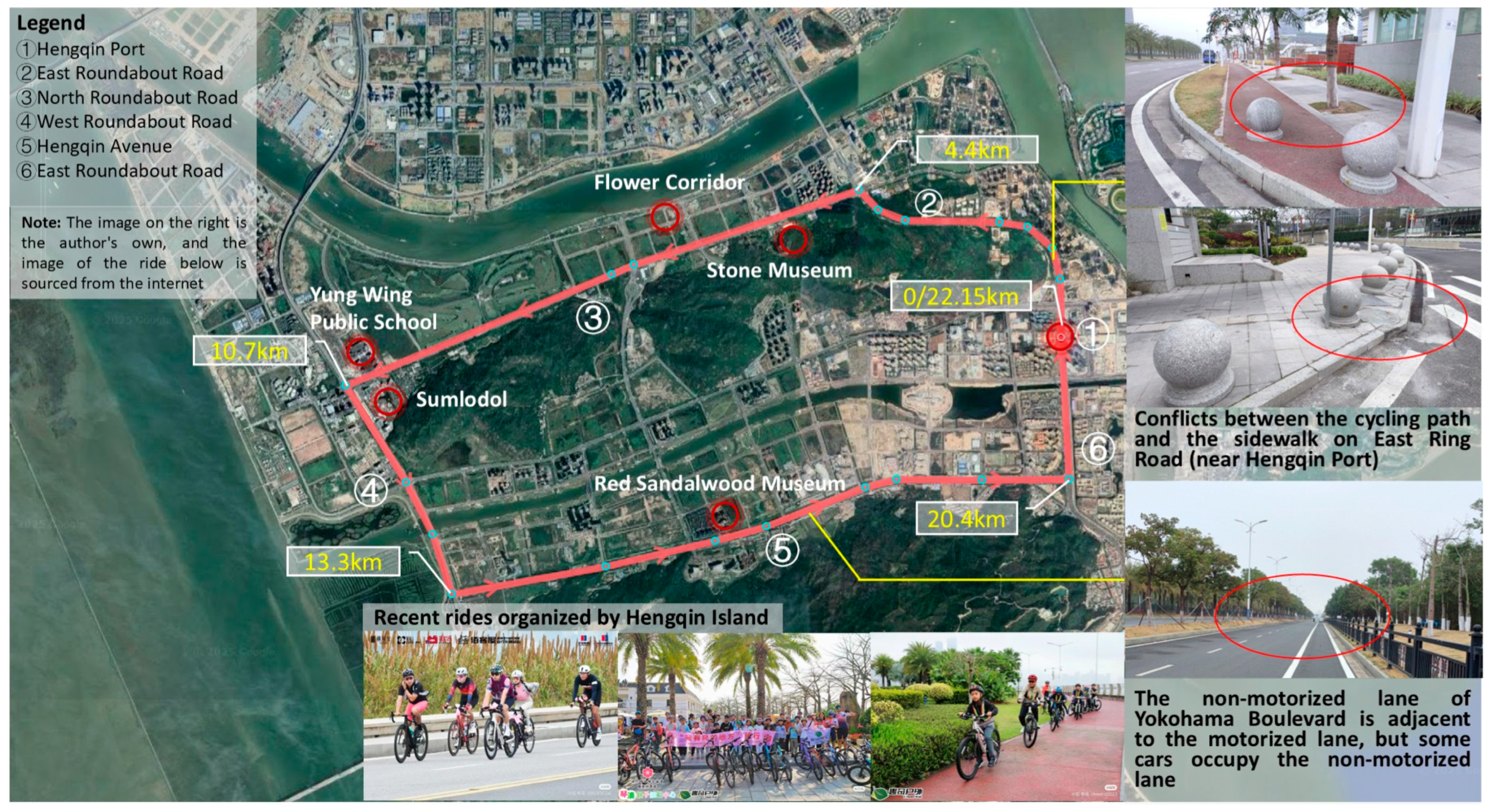
The framework of the cycling road network of the Hengqin Island circular route has been basically formed. The road pavement is mainly asphalt and masonry, and some sections of the North Roundabout Road are paved with rubberized ground, which effectively improves the coefficient of friction and reduces cycling energy consumption. However, there are obvious deficiencies in spatial layout and safety, as follows: the cracking and warping of floor tiles on the riding paths in the area of the border crossing, and the lack of a gentle slope transition at the interface between the riding paths and the motorized vehicles, which significantly increases the risk of falling; in addition to the local sections of North Roundabout Road, most road sections do not differentiate between the flow of electric vehicles and bicycles in non-motorized vehicle lanes, which results in frequent encounters at the rear with interference from motorized vehicles honking their whistles to overtake bicycles during cycling. Some sections of Hengqin Avenue lack physical separation between motor vehicles and non-motorized vehicles, and trucks temporarily occupy the roadway, forcing bicycles to pass through motor vehicles, posing a major safety hazard (
Figure 9).
In terms of cycling activities, Hengqin Island has organized and diversified activities covering all age groups (e.g., the 40 km loop in January 2025 will recruit experienced cyclists over 7 years of age), with short-distance routes focusing on the Flower Corridor section and long-distance loops oriented towards experienced cyclists, reflecting the public’s strong awareness of green travel and health. However, the publicity for green mobility and fitness for all along the routes is weak, public participation is not attractive enough, the reach rate of activity information is low, and the professionalism of on-site guidance and order maintenance need to be improved.
4.2. Analysis of the Status of Supporting Facilities
There are significant inequalities in the distribution of facilities and lack of services on the circular route. The layout of rest points is unbalanced, and some sections lack rain shelter and rest facilities. In terms of parking facilities, the convenience of renting and returning shared bicycles is high, but only Hengqin Port is equipped with special bicycle parking stakes, and the security of ordinary bicycle parking cannot be guaranteed in the remaining sections of the road (
Figure 10). The configuration of service facilities is also insufficient: although cyclists on the North Roundabout Road can conveniently reach the five well-supported campsites in the Flower Corridor through intersections, there is a serious lack of public restrooms in the remaining sections of the roundabout, forcing cyclists to limit their water intake. In addition, there is a lack of bicycle repair points along the entire route, making it impossible to deal with sudden vehicle breakdowns.
4.3. Summary of Three-Dimensional Contradictions
Based on the above analysis, the Hengqin Island cycling system has significant contradictions in the three dimensions of energy flow, information interaction, and spatial and temporal utilization. In the energy dimension, the coupling of summer heat and humidity, sunshine, wind speed, and terrain slope leads to uneven energy consumption, discomfort, and efficiency fluctuation, especially considering the heat island effect of Hengqin Avenue. In the information dimension, the disconnection of physical signs and the weak interpretation of cultural information hinder spatial cognition and cultural experience. In the spatial and temporal dimensions, there are significant differences in cycling demand between time periods and seasons, but the lack of flexibility in the layout of rest facilities, public toilets, and lighting, coupled with the impact of boring, long-distance road sections, exacerbates the physical and mental load on cyclists. Together, these contradictions constrain the effective interaction between cyclists and the “environment”.
5. Synergistic Quality Improvement Strategies and Practical Paths
Based on the above analysis, this study constructs a synergistic quality enhancement system from the three dimensions of background, activities, and construction, and proposes an actionable optimization path by combining economic feasibility and milestones.
In the context dimension, the focus is on microclimate regulation and ecological buffer zone construction. For the North and West Roundabout Roads, it would be appropriate to plant camphor and palm trees on both sides of the cycling paths, which are adapted to the climate of the south, and have both wind resistance and good shading effects, in order to optimize the thermal environment. For Hengqin Avenue, there is an urgent need to improve the physical separation between non-motorized vehicles and motorized vehicles through the planting of shrub communities to effectively absorb vehicle exhaust and radiant heat, in order to alleviate the local heat island effect. In addition, some sections of the road can consider laying a rubber riding surface to alleviate eye discomfort caused by ultraviolet reflection. The cost of this dimension mainly covers the following two parts: vegetation procurement and maintenance, and material renovation. The cost of a single tree plant ranges from CNY 500 to 1200, with an initial planned investment of about CNY 300,000 to 500,000 and an annual maintenance cost of about 15 percent of the initial investment; about CNY 900,000 will be invested in the renovation of the rubber ground. It is recommended that the financial pressure be effectively reduced through a multi-dimensional financing model of cooperation between the government and social enterprises.
In the activity dimension, efforts should be made to solve the physical signage disconnection and strengthen cultural information transmission. The Hengqin Port area should be equipped with comprehensive traffic guide signs, clearly presenting the accessibility of various modes of transportation, in order to efficiently ease the flow of people and optimize the travel experience. North Roundabout Road should build a continuous guiding information chain, and set up coastal landscape guide signs at key nodes (e.g., every kilometer spacing or fork in the road), so as to significantly reduce the error rate of path recognition. For non-motorized road positions, changed road sections must be laid with advance lane guide signs, as well as on non-motorized roads and sidewalks, adjacent to the use of height differences for physical isolation, in order to protect passage safety. Meanwhile, around cultural nodes such as Stone Museum, Sumlodol, Red Sandalwood Museum, and Yung Wing Public School, cultural information anchors should be constructed, and guide interpretation signs should be set up within 1–3 km before and after them to explain the connotation of the attractions in depth, to enhance attractiveness and to promote cultural perception. The cost of the signage system at the crossing point and cultural signage along the route will be about CNY 50,000–100,000, the cost per kilometer will be about CNY 10,000–15,000, and the total investment belongs to the category of small-scale traffic facility renovation. Through the strategies of “standardized design” and “scenic spots with common cultural content”, the efficiency of funding use can be significantly improved (
Figure 11).
In the construction dimension, the focus is on building flexible and responsive facilities and vibrant spaces. In order to adapt to the time and seasonal fluctuations in cycling behavior, it is appropriate to deploy solar street lamps along the second half of North Roundabout Road and West Roundabout Road to make full use of the advantage of regional sunlight resources and enhance the safety of cycling at night. West Roundabout Road and Hengqin Avenue should be dynamically configured with mobile rest stops and public toilets according to the seasonal flow, to ensure service supply in the spring, fall, and winter when the cycling demand is strong and moderately reduce the scale in the summer to realize the efficient deployment of resources. The Hengqin Avenue section can be equipped with additional cycling stations, which will serve as a vibrant node for cyclists to socialize and rest and effectively improve the spatial atmosphere of the road section. In addition, the public seats on the sidewalks of the ring road can be upgraded with integrated shade and rain protection functions to provide emergency shelters for pedestrians and cyclists to cope with sudden rain showers. The cost of resilient facilities is characterized by a significant “long-term gain over initial investment”. Investment of about CNY 60,000–120,000 is planned for solar streetlights, and the difference in the electricity cost of traditional streetlights can be recovered in 5 years of operation. Mobile rest stops can prolong their service life through “storage and preservation in off-season”, with a significant long-term economic performance. Cycling stations and seats with rain-shielding devices are planned to be renovated, with an investment of CNY 10,000–15,000, and the scale of the cost is positively correlated with the number of facilities. The source of funding can be based on “urban renewal + leasing of post advertising space” to realize a sustainable cycle.
The total initial investment of the three-dimensional strategy is about CNY 1.5–2 million, which can balance financial pressure through the phased implementation of “optimization of core road sections (1 year)–gradual expansion (2–3 years)”. The strategy not only fits the financial capacity of Hengqin Island, but also creates a virtuous cycle of “environment optimization–usage growth–benefit feedback”.
In summary, through microclimate and ecological optimization in the background dimension, signage improvement and cultural empowerment in the activity dimension, and resilient facilities and vibrant space creation in the construction dimension, a multi-dimensional synergistic quality enhancement system has been constructed, which can significantly improve the environmental comfort, information interaction efficiency, and comprehensive service capacity of the Hengqin Island cycling system.
6. Discussion
The study innovatively applies the mechanism of “human–environment interaction” of habitat theory to the study of cycling systems, breaking through the single perspective of traditional engineering that focuses on facilities, and constructs a three-dimensional analysis framework of “energy flow–information interaction–space–time utilization”. Through the integration of climate data and cycling behavior observation, the unique value of this theory in analyzing the interaction mechanism of natural energy metabolism, humanistic information transfer, and spatial–temporal behavior in the coastal cycling environment is verified, and a research paradigm shift from “static facility supply” to “dynamic human–environment interaction” is realized.
It should be pointed out objectively that the phenomenological approach focuses on the in-depth excavation of individual experience, and although this can capture subtle experiences such as “upwind resistance perception” and “glare discomfort” and provide a micro perspective for understanding “human–environment interaction”, it also has certain limitations: since the findings of the study are rooted in the subjective perceptions of a specific group of people (this study mainly focuses on general cyclists), it is necessary to adjust the findings considering the local situation and the characteristics of the group when directly referenced to other domains or special groups. The core value of this study is to provide a “paradigm for analyzing the experiential dimension”, leaving room for subsequent cross-group and cross-regional comparative studies.
The research results have important implications for practice. Firstly, they reveal the close coupling between microclimate and cycling experience: Hengqin Avenue results in a higher body temperature than North Roundabout Road due to the significant heat pollution zone formed by the wide road surface and the obstruction of high-rise buildings, which confirms the priority of optimizing ventilation corridors in the design of coastal cycling paths; the North/West Roundabout Roads have a relative heat dissipation advantage by virtue of the layout of the green belts, which highlights the key role of eco-design in mitigating heat stress. The climate regulates the energy metabolism of cyclists through thermal stress and the terrain through resistance, while the human being adapts through speed adjustment and reliance on vegetation buffer, forming a dynamic balance of “environmental constraints–human body response”. Second, the systematic disconnection in the dimension of information interaction is particularly prominent. The lack of an effective physical signage system and weak interpretation of cultural nodes, together, lead to a low willingness of cyclists to stay, which reveals the profound disconnection between the functional design and the user’s cognition, empirically proving the indispensability of humanistic information transmission to enhance the cycling experience. In the coupling mechanism, it is manifested in the following way: the physical marking break destroys the efficiency of the path, the cultural information break weakens the value of the experience, and the two are superimposed on each other, so cyclists cannot travel smoothly and do not want to stay, which ultimately reduces the overall experience. Third, we consider dynamic response requirements for spatio-temporal behavioral adaptation. The fluctuation in traffic flow between commuting hours, nighttime, and seasons shows that the static design of the cycling system (e.g., fixed resting points) can no longer meet the dynamic demand, and it is necessary to establish an elastic response mechanism that links the “demand–supply” linkage. The proposed strategies of solar lighting and seasonal facility scheduling are precisely to realize the matching of supply and demand through the dynamic scheduling of spatial and temporal resources, which provide ideas for the flexible adaptation of slow-moving systems in coastal cities.
7. Conclusions
The research systematically reveals the three-dimensional core contradictions of the cycling system in Hengqin Island under the framework of “human–environment interaction”, as follows: first, the energy flow dimension is affected by the hot and humid climate in summer and local terrain differences, resulting in an uneven distribution of energy consumption among cyclists, especially the significant thermal pollution problem of Hengqin Avenue. Second, there are dual constraints in the dimension of information interaction, such as the rupture of the physical identification system and the lack of cultural information, which significantly reduce the riding experience and lead to an increase in the error rate of path selection. Thirdly, in the dimension of spatio-temporal utilization, there is a prominent contradiction between the significant temporal and seasonal flow fluctuations and the lack of dynamic response mechanism for facility supply. Accordingly, the study proposes a three-dimensional collaborative quality improvement strategy of “background–activity–construction”, covering technical solutions such as microclimate regulation, intelligent signage system construction, and flexible facility layout, aiming to optimize cycling satisfaction and provide a practical paradigm for building a high-quality “cycling circle” in the Guangdong–Hong Kong–Macao Greater Bay Area.
The current study has limitations in sample coverage, failing to fully incorporate cycling groups of different ages (e.g., elderly cyclists), physical fitness gradients (professional riders vs. the general public), and multiple trip purposes (commuting/leisure/fitness), which may lead to biased perceptions of the cycling experience. Future research can adopt stratified sampling methods, integrate physiological detection technologies such as heart rate monitoring and eye tracking, construct a multi-dimensional cycling behavior database, and focus on exploring a refined demand adaptation mechanism for special groups (e.g., parent–child families, people with disabilities). To address the limitations of the phenomenological approach in terms of generalizability, subsequent studies can adopt a hybrid approach of “subjective experience + objective quantification” (e.g., combining cycling traffic statistics and physiological indicators) to enhance the generalizability of the conclusions. The follow-up study intends to analyze the mechanism of coordinated traffic scheduling and facility sharing of the cross-border cycling network in the Guangdong, Hong Kong, and Macao Greater Bay Area at the regional level and to explore the spatial coupling paths between cycling paths and ecological corridors such as the Tianmu River Vitality Belt and the Mangzhou Wetland at the city level, so as to deepen the study on the integration mechanism of the whole-area cycling network with the human habitat environment.
