1. Introduction
Walking is the most important mode of transportation for humans, playing a vital role in moving people to their desired destinations in urban areas [
1,
2]. Not all walks have the same purpose, with people walking for multiple reasons, such as transportation, leisure, exercise, interacting with people, or as an incidental activity (e.g., a waiter walks to perform their job) [
3,
4].
Despite its importance, every innovation in transport technology over the last two centuries has led to a degradation of walkable areas, with the dedication of considerable public space to automobile circulation and parking being of concern [
5,
6,
7]. Pedestrians are left with a small portion of space, often in disrepair, to enjoy and walk in [
2,
5]. Public space has become devoid of citizen permanence and livelihood, as people find these spaces unpleasant [
8].
With the turn of the century, urban areas around the globe have started to shift from car-centric planning to approaches that favor alternative forms of transportation, such as walking, cycling, and public transport [
9,
10,
11]. This paradigm shift can be associated with a change in urban planning thinking, as the modernist current, which disregarded citizen involvement in public space creation, has been substituted by new approaches that conceptualize public participation within urban planning and design [
12,
13,
14]. Despite these changes in urban planning thinking, walkability studies (defined by their focus on modifying urban environments to be more pedestrian-friendly) still mostly use quantitative approaches that measure walkability without considering the subjective drivers that influence it [
15,
16].
Within this context, biosensing studies can present themselves as an appropriate methodology to study the more personable aspects of walkability and how to improve urban space to suit users’ experiences better [
17]. Nevertheless, the usage of biosensing in walkability studies remains understudied, except for a few recent studies [
18,
19].
The main objective of this article is to understand how to promote citizens’ direct involvement in urban planning and design processes, using biosensing participative methodologies, to improve walkability within the planning and design of commercial streets. The commercial streets are in the Lisbon Metropolitan Area, Portugal (the Avenida da Igreja, Lisbon, and Rua Pulido Valente, Odivelas). The Participatory Mobile Biosensing (PMB) methodology was applied. It consists of two main stages. The first one involved participants walking for around 15 min on the street. The second stage consisted of a workshop, where participants were asked to describe their walk and to create scenarios that envisioned a street to mitigate negative emotions and highlight positive ones. This study aims to prove that PMB is an efficient methodology for helping the creation of urban environments that are unique and better adapted to user sensibilities and experiences.
This article is divided into four chapters. The first one regards the literature review, in which a careful exploration of the walking experience and walkability and its approach in urban studies is conducted, in addition to discussing how biosensing technology can help further this study. The literature review was conducted with a narrative focus instead of a systematic one, and it was produced using articles found on Google Scholar, Scopus, and Web of Science. The second chapter seeks to explain the PMB methodology and contextualize the study areas. The third chapter explores the main results obtained from the realization of this study. The last chapter reflects on how the PMB methodology can be best applied to improve the walking experience and walkability in public spaces.
2. Walkability
As a concept, walkability is not well-defined in the scientific literature, as multiple authors have utilized this term for different objectives [
4]. This dubiousness has been attributed to its transformation in mobility studies, from a general understanding that successful and vibrant neighborhoods are designed to appeal to walking, as proposed by Jane Jacobs, to a quantitative measure that evaluates a place’s distance to daily amenities, services, and commerce [
20,
21,
22].
Nevertheless, most definitions utilized in the scientific literature can be categorized based on whether they exclusively consider physical elements or also consider subjective elements [
15]. Authors such as Southworth, Dovey, Pafka, and Cambra focus solely on physical aspects, mostly categorizing it as how the physical characteristics of the built environment enable walking [
23,
24,
25]. We can correlate this first group of definitions with strict definitions of objective walkability, which is defined as the physical factors that influence the walking experience [
15]. However, Fonseca et al., Forsyth, and Tobin et al. consider this definition reductionist, expanding it to include intangible aspects such as sense of security and social and individual factors that influence the walking experience [
4,
16,
26]. This last group can be correlated with an expansion of the concept to contain elements of perceived walkability (also called subjective walkability), which can be described as the ease with which people consider walking [
15,
27]. This is important because De Vos et al. found a bigger influence of perceived walkability on the decision to walk than objective walkability, revealing that it is important to consider a broader definition to study walkability adequately [
15,
27].
Multiple physical elements affect the walking experience, including the walking infrastructure, such as sidewalks or pedestrian network, the structure of the surrounding urban space, including buildings and the activities inside them, the interaction with other modes of transportation, such as public transit and car traffic, and the presence of other pedestrians. Consequently, we provide a synthesis of the identified physical elements that can facilitate the creation of highly walkable environments, as highlighted in walkability and public space studies (
Table 1).
Nonetheless, physical characteristics are not the only factors that affect walkability, as factors related to the individuals themselves are of large influence, as well as how they perceive the environment around them. To explain these factors, Alfonzo created the hierarchy of walking needs, based on the unconscious evaluation all walkers take when deciding to walk [
4,
41,
42]. These needs were hierarchized by their importance: viability, accessibility/utility, security, comfort, pleasurability (which includes sensory pleasure), and community [
41]. For someone to consider walking, not all conditions must be satisfied, and if all conditions are satisfied, it does not necessarily mean that someone will choose to walk [
25,
41,
43]. Viability is the first decision all pedestrians make, and they will decide if it is practical to make this journey by walking [
28,
41]. This is directly influenced by the person’s physical characteristics and whether they are directly responsible for another person when walking [
41]. Secondly, a person will consider accessibility, which centers on the amenities of a place, and the physical and perceived connectedness to them, by considering the pedestrian network that allows them to travel between them, and any barriers found on the journey [
25,
41]. Mehta further elaborated on the accessibility factor and added utility to this pyramid, which is related to how the area within a walkable radius can satisfy a person’s daily needs for shopping, entertainment, and food [
44]. Next, a person will consider security, which is whether they feel safe from perceived and physical dangers, such as crime and traffic [
41]. Next, they will consider comfort, which is associated with the convenience and individual satisfaction felt when walking [
25,
28]. After this, they will consider pleasurability, which is how much pleasure and interest they have when walking, and this is influenced by aesthetics, architecture, and the level of activity of a street [
25,
41]. These elements are then perceived by the senses, leading to the sensorial pleasure mentioned by Mehta [
44]. Lastly, they will consider their sense of belonging to their community [
28,
44]. All these factors are then influenced by moderators, which may be individual (encompassing psychological, demographic, and biological factors, such as a persons enjoyment of walking), group (including cultural or sociological elements, such as belonging to a society that heavily encourages walking), and regional (pertaining to natural conditions affecting walking, such as temperature and topography) [
41,
45,
46].
Nevertheless, it is also important to explore how walkability is measured. There are two types of measures most used in walkability studies, objective and subjective, which can be combined to minimize their limitations and obtain more accurate results [
9,
16,
27]. Objective measures are based on immediate reality and mostly use quantitative measures, such as indices, to measure built environment attributes, such as the amenities available to people at a walkable distance [
16,
47]. Objective studies are mostly used at a neighborhood scale, as they are more difficult to operate at street level [
48]. Widespread examples of these methods are the Walk Score, Walkability Index, and the 5D Model [
37,
47,
48,
49]. These studies are criticized for their oversimplification of reality and for discrediting individual and other subjective factors within their methodology, but their ease of use and wide availability make them an appealing tool for the study of walkability [
27,
50,
51].
On the other hand, subjective measures try to measure the perceptions, opinions, and behaviors of pedestrians [
27,
47]. These methods use quantitative data, such as the NEWS method and the 7 C’S method, or qualitative data, which conduct evaluations based on mental maps, walking interviews, and focus groups to study how people perceive an area’s walkability [
27,
36,
47,
52]. These methods, however, are criticized due to their lack of precision with the answers provided by the pedestrians, as these can be biased [
27,
47].
3. Biosensing
To fully understand how to utilize biosensing technology in walkability studies, a detailed exploration of these methods was necessary. Biosensing, in its essence, is about the usage of physiological indicators of emotional stimulation to indicate the emotional state of an individual [
17]. There are several physiological measures that biosensing can measure, but, in the context of this article, only electrodermal activity (EDA) was considered [
17,
53,
54]. EDA is the totality of electrical phenomena on the skin [
55]. It is regulated by the sympathetic nervous system and, therefore, can be associated with emotional stimulation (which measures the intensity of an emotion) [
56]. This measurement is influenced by internal, external, and medical factors, which need to be considered when interpreting the data [
55].
Biosensing technology presents multiple upsides to its use, such as making data collection simpler and more trustworthy, by allowing real-time measurement and easing participant fatigue [
12,
57,
58,
59]. However, it also has multiple limitations, especially pertaining to data quality and its challenges and considerations in data interpretation [
17]. Nevertheless, when considering EDA, its biggest limitation is that the data cannot be associated with the valence of an emotion (related to how pleasurable an emotion is), needing a complementary method to be used to fully grasp the emotional experience of the users [
18,
56]. To help improve the interpretation of biosensing data, it is often combined with GPS technology, helping to locate the points where the users felt the emotions, and with qualitative methods, which enable the participants to interpret the data and to state the emotions felt during the time they were using it [
53,
60].
In this sense, biosensing technology can improve citizens’ interest in participating in urban planning and design processes [
14,
61]. During the 20th century, citizens were mostly excluded from these processes, but with the rise of the contemporary city, the incorporation of citizen opinions became important [
12,
14]. Historically, the tools and methodologies available to urban planners have been proven insufficient to handle this shifting tide; therefore, the utilization of biosensing can serve as an opportunity to change this [
14]. However, when these technologies are not used with the involvement of their users, they can help perpetuate the detachment of citizens from planning processes, but when they are, they can be an important tool for bottom-up planning approaches [
12,
60,
62].
The intersection between biosensing and walkability studies remains insipient, although it has started to be further explored by authors such as Harvey and Kim et al., who extracted somatic responses from participants’ reactions to the surrounding built environment [
18,
19]. Harvey’s study measured participants’ somatic responses, revealing elevated EDA in emotionally thrilling places, such as crosswalks, and a positive relation between EDA values and physical characteristics that enhance walkability, such as appealing storefronts, abundant windows, and the presence of trees [
18]. Kim et al. also correlated the influence of negative environmental stimuli, such as sidewalk inexistence and steepness, on emotional distress through EDA using machine learning algorithms [
19].
However, the improvement in walkability using the emotions experienced by pedestrians that managed to incorporate objective and subjective measures, but avoided the subjectivity inherent to participative methods, was not found in the walkability literature. Therefore, this investigation could serve as an opportunity to explore this.
4. Materials and Methods
The purpose of this study was to comprehend how the direct involvement of citizens can be enhanced in urban planning and design processes to improve the walkability of high streets.
The study areas considered were Avenida da Igreja, Alvalade, Lisbon, and Rua Pulido Valente, Colinas do Cruzeiro, Odivelas. Both streets are important commercial streets within their respective contexts—urban (Alvalade) and suburban (Colinas do Cruzeiro). Despite being conceptualized as walking spaces, they are still plagued with problems common to most streets in the Lisbon Metropolitan Area, such as car dominance, bad quality sidewalks and urban furnishings, and generalized negligence, needing urgent improvements [
60,
63].
The Alvalade neighborhood dates from 1945, and its plan is an example of modernist planning, incorporating neighborhood units and featuring a public facility at its center, which is at a walkable distance [
64]. It is home to an aging population of around 25,000 inhabitants, spread over 2.35 km
2 [
65]. Avenida da Igreja serves as its main east–west axis and as its main commercial street [
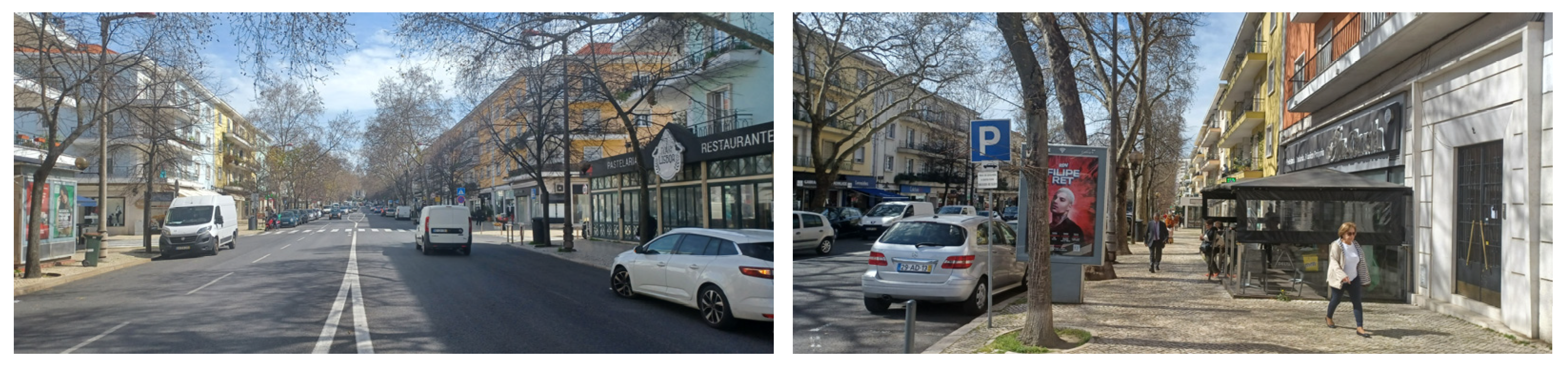
66]. It can be considered a central place in the city’s commercial structure, as it is home to a diverse and well-established commercial infrastructure (
Figure 1) [
67]. Nevertheless, despite being home to a sizeable collection of urban furnishings, its low adaptation for convivial activities and a large presence of automobiles in the public space detracts from users’ permanence here (
Figure 2).
The Colinas do Cruzeiro neighborhood was developed more recently, dating from 2001, with most of its buildings being built over the following 4 years [
68]. It is home to a younger population of around 11,000 inhabitants, spread over 0.66 km
2 [
65]. Rua Pulido Valente is its most important commercial street, even though it was not designed to be [
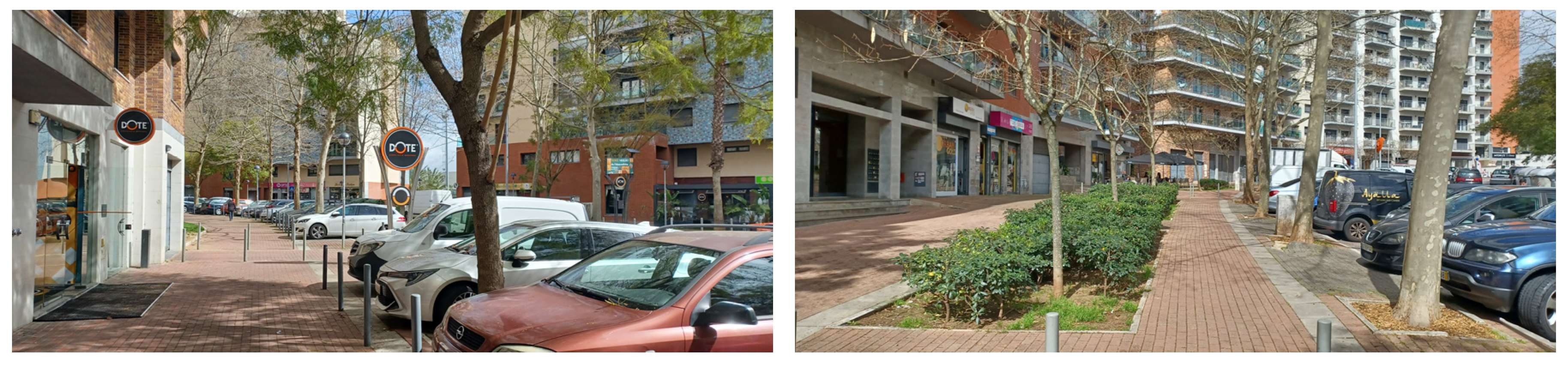
69]. It can be considered a non-central location in the city’s commercial structure, but is still home to a lively commercial dynamic (
Figure 3) [
67]. Despite a significant presence of green space and esplanades, the lack of non-commercial spaces for people to stay in detracts from their permanence (
Figure 4).
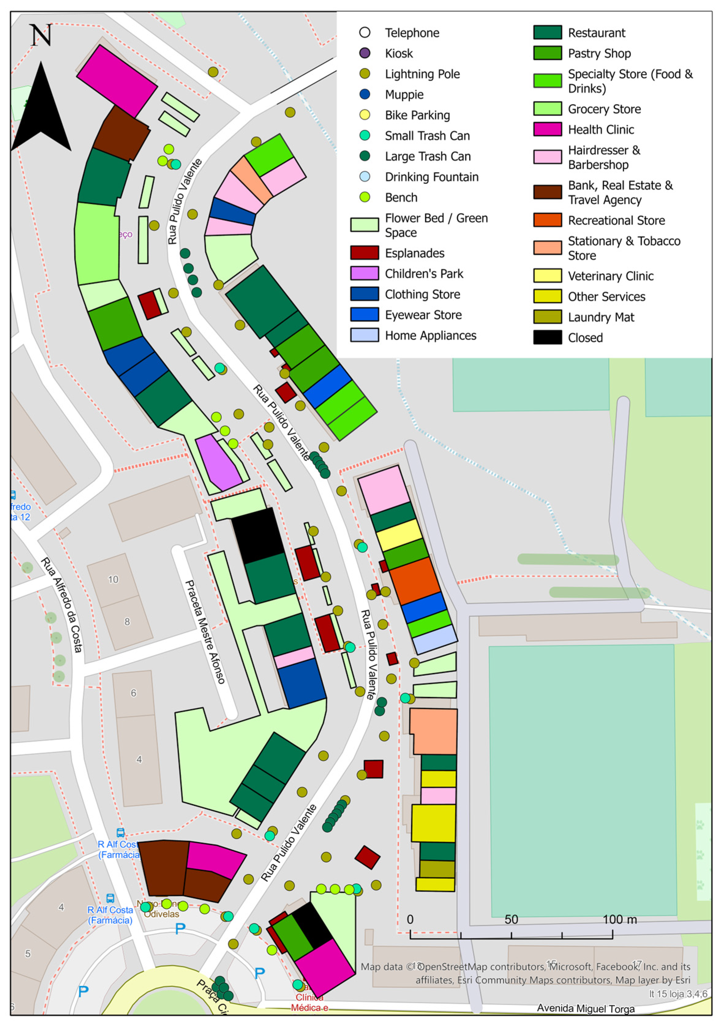
As previously stated, the methodology used in this study was Participatory Mobile Biosensing (PMB). It was developed under the UrBio project as a qualitative and participatory method for urbanists to co-design urban scenarios with the population, in a way that is sensitive to the emotional dimension of the city, using biosensing technology. Biosensing was utilized as a narrative trigger, allowing the participants to further develop their considerations about the walking experience, rather than as an independent source of data.
This methodology is divided into two parts: the transect walk and the workshop. The workshop is divided into two stages: the mapping and the co-creation stages. The transect walks consisted of participants walking on the street for around 15 min. They were carried out between 11 h and 17 h on sunny days to minimize the effects of temperature and humidity on the data. The participants were equipped with an Empatica E4 wristband, which measured their EDA, and a GPS tracker. The Empatica E4 is frequently used in biosensing studies, due to its high reliability, low weight, and discreetness [
53,
54,
70]. The biosensor is placed on the non-dominant hand and skin-tight to capture better data quality [
17,
57]. It measures skin conductance (among other physiological responses), of which the EDA data can be extracted [
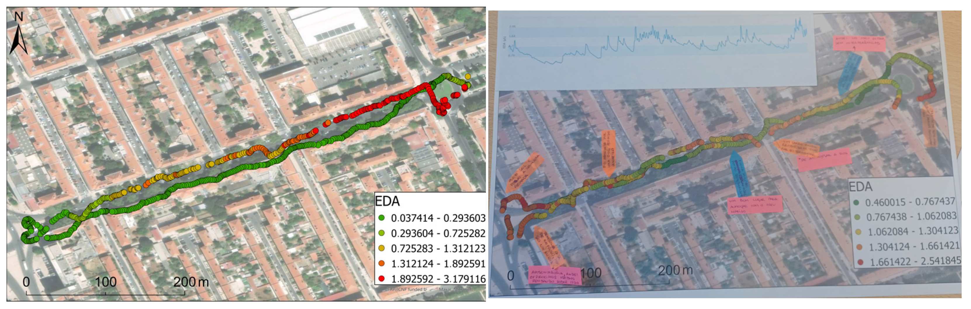
70]. The EDA was matched with the GPS data, and emotional maps with these data were formulated for each of their walks, allowing the emotional data to be located.
For the mapping stage of the workshop, the participants were given the cartography that resulted from their transect walk (
Figure 5). Its purpose was for the participants to contextualize the EDA data. The participants were then asked to note points of reference for their walk, where they felt positive, negative emotion, or affective memory (
Figure 5). After this, they provided a concise 5 min summary of their walk and further explained the points of reference highlighted. This explanation enabled the researchers to understand the valence of the emotional data, which could not be measured through biosensing, and to give a succinct explanation of the reasons they felt the emotions registered in the Empatica E4 [
18,
56].
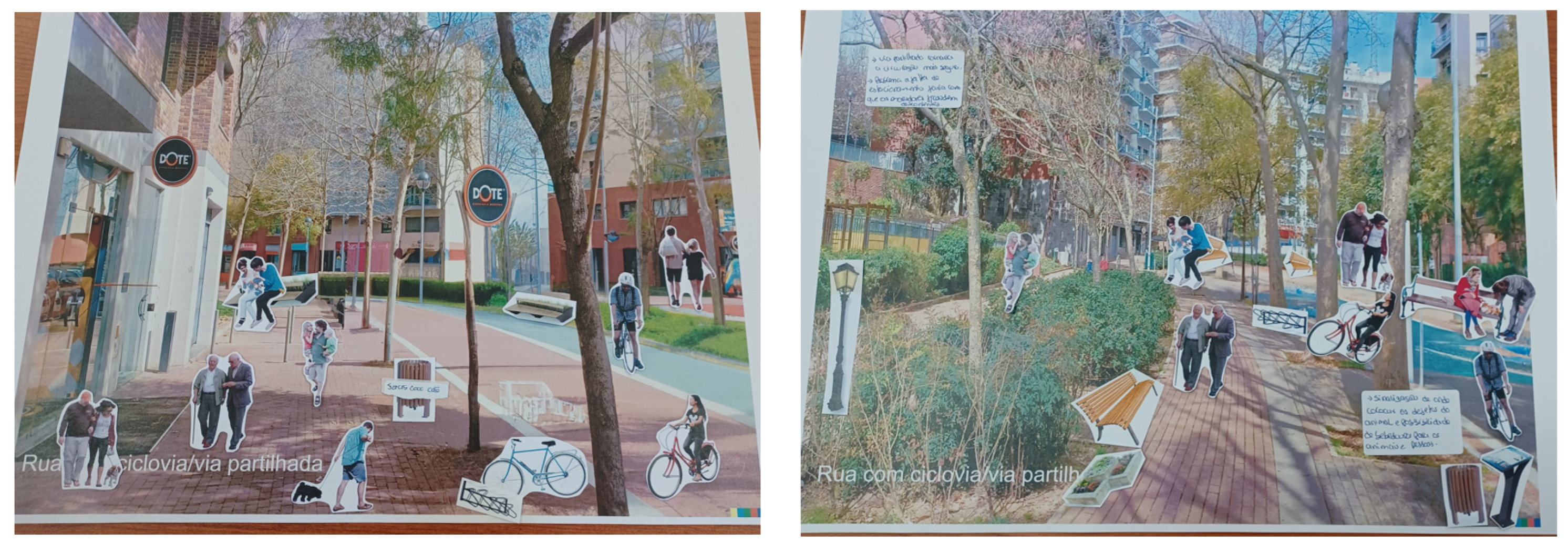
For the co-creation stage of the workshop, they were given three scenarios of different points on the street where they walked. These three scenarios consisted of an unaltered picture of the street as it currently was, and two altered images created with the artificial intelligence tool DALL-E 2. The AI model was provided with unaltered images and instructed to generate (1) a street with more space for pedestrians, less space for automobiles, and a cycle path, and (2) a completely pedestrianized street. For the participants to complete their scenarios, they were given an envelope containing images of urban furnishings and people performing activities. They were asked to develop these scenarios to elicit positive emotions and mitigate negative feelings during their walk (
Figure 6). After this, the participants gave a concise 5 min summary of their results.
For the Avenida da Igreja study area, 13 participants were asked to participate, and the study was conducted in April 2023. A total of 15% of participants were residents in Alvalade, and the other 85% were residents in other areas of Lisbon. Most participants (54%) were between 20 and 29 years old, 23% of participants were between 40 and 49, 15% of participants were between 50 and 59, and 8% of participants were between 30 and 39. The sample was balanced in gender, with 54% of the participants identifying as female and 46% as male. The sample was highly educated, with 54% possessing a bachelor’s degree and 46% possessing a master’s degree.
For the Colinas do Cruzeiro study area, 18 participants were asked to participate, and the study was conducted between May and July of 2023. A total of 39% of the participants were residents in the neighborhood, and the remaining 61% were residents in other parts of Odivelas. The participants were of all ages, with a third being between 20 and 29 years old, 22% being between 40 and 49 and between 60 and 69, and 6% being 19 years old or less, between 30 and 39, between 50 and 59, and over 70 years old.
6. Discussion
When presenting the results, it was noticeable how the participants navigated and interpreted the environment around them and how the PMB enabled such results. It was also noticed that the application of PMB further enables the study of walkability and helps create better-suited environments.
Overall, the PMB methodology proves to be valuable in engaging residents in the assessment of walkability in these areas, owing to the significant commercial activity and relatively adequate physical qualities of the pedestrian pathways on both streets. When analyzing the statements from the mapping part of the workshop and the scenario co-creation, most concerns and characteristics relate to secondary aspects of the hierarchy of walking needs. Most concerns pertain to security (e.g., security from traffic or personal security when walking at night), comfort (e.g., the quality of the pavement), and pleasurability and sensorial pleasure (e.g., the beauty of the trees lining the street) [
23,
28,
41,
44,
46]. This means that viability, accessibility, and utility are needs that are largely satisfied, with the case of a few exceptions (e.g., the sidewalk narrows at some points, which stops people with reduced mobility from walking on the street). However, most walkability studies are currently focused on the satisfaction of the most basic needs by analyzing the extension and connectivity of the walkable infrastructure (relating to viability) and whether there are amenities at a walkable distance (relating to accessibility and utility). Most studies also base their methodologies on objective and quantitative data. This can be correlated to the prevalence of problems regarding perceived walkability on high streets, while most studies use methods that focus on problems associated with objective walkability. So, for cases such as high streets, there is a gap between methodologies and reality. The walkable spaces in these streets are still riddled with problems, which would be undetected by studies that only consider these physical aspects. With PMB, we can identify these problems and work with users to improve the walkability of these spaces.
The PMB methodology was effective not only for the participants to notice how the material aspects of the street affected their walk, but also showed potential in helping pedestrians understand how the immaterial aspects affect their walk. The participants approached the topics regarding their psyche when walking (such as sense of security and how their perceptions of the surrounding environment affected their journey). As this methodology incorporates emotional components into the analysis of walkability, it enables researchers to understand how the intangible aspects of walkability affect the experience. As previously stated, most research on this topic is geared towards how the improvement in the physical aspects of the street can improve overall walkability, without considering elements of perceived walkability [
16,
27,
47,
50,
51]. Therefore, PMB can help close this knowledge gap and create public spaces that are more adapted to pedestrians’ needs.
The PMB methodology also showed itself to be useful in understanding how the physical characteristics of walkability impact the overall walking experience. When correlating the physical characteristics synthesized in
Table 1 with the discussions presented in the results section, it was observed that most concerns refer to the relationship between automobiles and pedestrians. Most participants understood that to improve public walkable space, it was necessary to remove car parking and circulation, suggesting that the newly available space could be used not only for walking but also to enable other activities that could improve the walking experience.
7. Conclusions
This article demonstrates that through biosensing participatory methodologies, such as the PMB methodology, citizens can be more involved in urban planning and design processes, creating more walkable public spaces in high streets that are better suited to their needs. The PMB methodology was effective not only in identifying the physical characteristics that affect walkability but also in pinpointing the intangible aspects. The PMB methodology further demonstrated that it was an adequate methodology for high streets, as it could identify problems that traditional objective and quantitative measures could not and create personalized solutions to solve them. It also enabled detailed descriptions of how the participants wanted the street to be.
Among the principal limitations found were time constraints, as interventions from all participants were restricted to 5 min each so as not to create participant fatigue. Constraints related to the sample were also identified, as there was some difficulty gathering participants who were residents of the neighborhood, with this being minimized by trying to find residents and workers from nearby neighborhoods, which can enable conclusions to be drawn that might not align with the opinions and interpretations of segments of the resident population. As all walks were made explicitly for this study, having a leisurely purpose in mind, it influenced how people experienced and interacted with the public space around them [
3,
4]. There was also an impossibility in comparing the results from both study areas, due to the problems and solutions being highly site-specific. The use of biosensing as a narrative trigger could also introduce further limitations, as participants can not only influence the interpretation of the data but can also be influenced by the data itself and try to reshape their interpretation to match the data [
60]. A further limitation is the time of day at which the transect walks were recorded. To limit the influence of external factors, they were all carried out during business hours on sunny days, which can lead to an assessment of the needs of the pedestrians on the street that may not be correct during the night, on rainy days, or on weekends.
In further studies, more research needs to be devoted to improving walkability using physiological and sensorial aspects, as research on this topic remains scattered and understudied. An aspect that could be further analyzed is representativity, as it could allow underrepresented groups, such as older and disabled people, to gain more representation in walkability studies, allowing for a walkable space more suited to their specific needs. There could also be studies that include other technologies, such as EEG, as they can also help mitigate one of the main limitations of biosensing with EDA, which is not being able to understand emotional valence. These studies should include citizens’ opinions and perspectives so as not to further alienate them from these studies and to create better-suited solutions [
14,
53,
60]. In a post-modernist era of urbanism, the potential of methodologies such as the PMB methodology is necessary to continue so that people are included in the planning of the spaces they use.


