
Quality Assessment of Cycling Environments Around Metro Stations: An Analysis Based on Access Routes

 ,
,
Abstract
:1. Introduction
2. Literature Reviews
2.1. Bicycle Environment and Cycling Access
2.2. Quality Assessment of Bicycle Environment
3. Research Design and Method
3.1. Method
3.1.1. Modelling Design
3.1.2. Filtration of Evaluation Indicators
3.1.3. Objective Weights of Indicators
3.1.4. Subjective Weights of Indicators
3.1.5. Composite Weights of Indicators
3.1.6. Composite Weights of Criteria
3.1.7. Validating Evaluation Results
3.2. Study Area
3.3. Data Sources
3.3.1. Open Data
3.3.2. Survey Data
4. Results
4.1. Quality Evaluations Based on Cycling Routes
4.1.1. Accessibility
4.1.2. Safety
4.1.3. Convenience
4.1.4. Comfort
4.1.5. Overall Evaluations
4.2. Verification of Assessments
5. Discussions and Conclusions
Author Contributions
Funding
Data Availability Statement
Conflicts of Interest
References
- Lu, K.; Han, B.; Lu, F.; Wang, Z. Urban rail transit in China: Progress report and analysis (2008–2015). Urban Rail Transit 2016, 2, 93–105. [Google Scholar] [CrossRef]
- Bao, X. Urban rail transit present situation and future development trends in China: Overall analysis based on national policies and strategic plans in 2016–2020. Urban Rail Transit 2018, 4, 1–12. [Google Scholar] [CrossRef]
- de Souza, F.; La Paix Puello, L.; Brussel, M.; Orrico, R.; van Maarseveen, M. Modelling the potential for cycling in access trips to bus, train and metro in Rio de Janeiro. Transp. Res. Part D Transp. Environ. 2017, 56, 55–67. [Google Scholar] [CrossRef]
- Ma, X.; Ji, Y.; Jin, Y.; Wang, J.; He, M. Modeling the factors influencing the activity spaces of bikeshare around metro stations: A spatial regression model. Sustainability 2018, 10, 3949. [Google Scholar] [CrossRef]
- Kim, M.; Cho, J.H. Analysis on bike-share ridership for origin-destination pairs: Effects of public transit route characteristics and land-use patterns. J. Transp. Geogr. 2021, 93, 103047. [Google Scholar] [CrossRef]
- Chen, Z.; Lierop, D.; Ettema, D. Dockless bike-sharing systems: What are the implications? Transp. Rev. 2020, 40, 333–353. [Google Scholar] [CrossRef]
- Hoedl, S.; Titze, S.; Oja, P. The bikeability and walkability evaluation table: Reliability and application. Am. J. Prev. Med. 2010, 39, 457–459. [Google Scholar] [CrossRef]
- Nielsen, T.A.S.; Skov-Petersen, H. Bikeability-urban structures supporting cycling: Effects of local, urban, and regional scale urban form factors on cycling from home and workplace locations in Denmark. J. Transp. Geogr. 2018, 69, 36–44. [Google Scholar] [CrossRef]
- Hochmair, H.H. Assessment of bicycle service areas around transit stations. Int. J. Sustain. Transp. 2015, 9, 15–29. [Google Scholar] [CrossRef]
- Saghapour, T.; Moridpour, S.; Thompson, R.G. Measuring cycling accessibility in metropolitan areas. Int. J. Sustain. Transp. 2017, 11, 381–394. [Google Scholar] [CrossRef]
- Zhao, P.; Li, S. Bicycle-metro integration in a growing city: The determinants of cycling as a transfer mode in metro station areas in Beijing. Transp. Res. Part A Policy Pract. 2017, 99, 46–60. [Google Scholar] [CrossRef]
- Lin, D.; Zhang, Y.; Zhu, R.; Meng, L. The analysis of catchment areas of metro stations using trajectory data generated by dockless shared bikes. Sustain. Cities Soc. 2019, 49, 101598. [Google Scholar] [CrossRef]
- Guo, Y.; He, S.Y. Built environment effects on the integration of dockless bike-sharing and the metro. Transp. Res. Part D Transp. Environ. 2020, 83, 102335. [Google Scholar] [CrossRef]
- Wang, R.; Lu, Y.; Wu, X.; Liu, Y.; Yao, Y. Relationship between eye-level greenness and cycling frequency around metro stations in Shenzhen, China: A big data approach. Sustain. Cities Soc. 2020, 59, 102201. [Google Scholar] [CrossRef]
- Lin, J.; Zhao, P.; Takada, K.; Li, S.; Yai, T.; Chen, C.H. Built environment and public bike usage for metro access: A comparison of neighborhoods in Beijing, Taipei, and Tokyo. Transp. Res. Part D Transp. Environ. 2018, 63, 209–221. [Google Scholar] [CrossRef]
- Yang, Q.; Cai, J.; Feng, T.; Liu, Z.; Timmermans, H. Bikeway provision and bicycle commuting: City-level empirical findings from the US. Sustainability 2021, 13, 3113. [Google Scholar] [CrossRef]
- Castañon, U.N.; Ribeiro, P.J.; Mendes, J.F. Evaluating urban bikeability: A comprehensive assessment of Póvoa de Varzim’s network. Sustainability 2024, 16, 9472. [Google Scholar] [CrossRef]
- La Paix Puello, L.; Geurs, K.T. Modelling observed and unobserved factors in cycling to railway stations: Application to transit-oriented-developments in the Netherlands. Eur. J. Transp. Infrastruct. Res. 2015, 15, 27–50. [Google Scholar] [CrossRef]
- Fernández-Heredia, Á.; Jara-Díaz, S.; Monzón, A. Modelling bicycle use intention: The role of perceptions. Transportation 2016, 43, 1–23. [Google Scholar] [CrossRef]
- Ma, L.; Ettema, D.; Ye, R. Determinants of bicycling for transportation in disadvantaged neighbourhoods: Evidence from Xi’an, China. Transp. Res. Part A Policy Pract. 2021, 145, 103–117. [Google Scholar] [CrossRef]
- Wu, J.; Yang, M.; Sun, S.; Zhao, J. Modeling travel mode choices in connection to metro stations by mixed logit models: A case study in Nanjing, China. Promet-Traffic Transp. 2018, 30, 549–561. [Google Scholar] [CrossRef]
- Yang, Q.; Zhang, Z.; Cai, J.; Ding, M.; Li, L.; Zhang, S.; Ling, Y. Quality of pedestrian networks around metro stations: An assessment based on approach routes. Systems 2025, 13, 63. [Google Scholar] [CrossRef]
- Wu, X.; Lu, Y.; Lin, Y.; Yang, Y. Measuring the destination accessibility of cycling transfer trips in metro station areas: A big data approach. Int. J. Environ. Res. Public Health 2019, 16, 2641. [Google Scholar] [CrossRef] [PubMed]
- Alveano-Aguerrebere, I.; Ayvar-Campos, F.J.; Farvid, M.; Lusk, A. Bicycle facilities that address safety, crime, and economic development: Perceptions from Morelia, Mexico. Int. J. Environ. Res. Public Health 2018, 15, 1. [Google Scholar] [CrossRef]
- Gan, Z.; Yang, M.; Zeng, Q.; Timmermans, H.J. Associations between built environment, perceived walkability/bikeability and metro transfer patterns. Transp. Res. Part A Policy Pract. 2021, 153, 171–187. [Google Scholar] [CrossRef]
- Mertens, L.; Compernolle, S.; Deforche, B.; Mackenbach, J.D.; Lakerveld, J.; Brug, J.; Roda, C.; Feuillet, T.; Oppert, J.M.; Glonti, K. Built environmental correlates of cycling for transport across Europe. Health Place 2017, 44, 35–42. [Google Scholar] [CrossRef]
- Wang, D.; Jin, M.; Tong, D.; Chang, X.; Gong, Y.; Liu, Y. Evaluating the bikeability of urban streets using dockless shared bike trajectory data. Sustain. Cities Soc. 2024, 101, 105181. [Google Scholar] [CrossRef]
- Chen, P.; Shen, Q.; Childress, S. A GPS data-based analysis of built environment influences on bicyclist route preferences. Int. J. Sustain. Transp. 2018, 12, 218–231. [Google Scholar] [CrossRef]
- Cai, J.; Yang, Q.; Huang, J.; Du, W.; Zhang, D. Improving urban road network planning with multimodal travel: A case study of practices in Seattle, USA between 1998 and 2019. Urban Transp. China 2023, 21, 28–37. [Google Scholar]
- Hardinghaus, M.; Nieland, S.; Lehne, M.; Weschke, J. More than bike lanes—A multifactorial index of urban bikeability. Sustainability 2021, 13, 11584. [Google Scholar] [CrossRef]
- CROW-Fietsberaad. Design manual for bicycle traffic. Available online: https://crowplatform.com/product/design-manual-for-bicycle-traffic/ (accessed on 31 December 2016).
- Copenhagenize_Design_Company. The Copenhagenize bicycle friendly cities index. 2019. Available online: https://copenhagenizeindex.eu/the-index (accessed on 31 March 2019).
- Kazemzadeh, K.; Laureshyn, A.; Winslott Hiselius, L.; Ronchi, E. Expanding the scope of the Bicycle Level-of-Service concept: A review of the literature. Sustainability 2020, 12, 2944. [Google Scholar] [CrossRef]
- Ayachi, F.S.; Dorey, J.; Guastavino, C. Identifying factors of bicycle comfort: An online survey with enthusiast cyclists. Appl. Ergon. 2015, 46 Pt A, 124–136. [Google Scholar] [CrossRef] [PubMed]
- Winters, M.; Teschke, K.; Brauer, M. Bike score: Associations between urban bikeability and cycling behavior in 24 cities. Int. J. Behav. Nutr. Phys. Act. 2016, 13, 72–73. [Google Scholar] [CrossRef] [PubMed]
- Xiao, H.; Qiu, X.; Li, L.; Chen, Z. Evaluation method of comfort of public bicycle routes in Xiamen. Technol. Innov. Appl. 2019, 30, 3. [Google Scholar]
- Fang, X.; Chen, X.; Ye, J. Method of classification criteria about quality of service for bicycle lanes. J. Tongji Univ. 2016, 44, 1573–1578. [Google Scholar]
- Tang, Z.; Yang, K.; Ren, Y.; Gao, Y. Road crowd-sensing with high spatio-temporal resolution in big data era. Acta Geod. Cartogr. Sin. 2022, 51, 1070. [Google Scholar]
- Boss, D.; Nelson, T.; Winters, M.; Ferster, C.J. Using crowdsourced data to monitor change in spatial patterns of bicycle ridership. J. Transp. Health 2018, 9, 226–233. [Google Scholar] [CrossRef]
- Hochmair, H.H.; Bardin, E.; Ahmouda, A. Estimating bicycle trip volume for Miami-Dade county from Strava tracking data. J. Transp. Geogr. 2019, 75, 58–69. [Google Scholar] [CrossRef]
- Gu, P.; Han, Z.; Cao, Z.; Chen, Y.; Jiang, Y. Using open source data to measure street walkability and bikeability in China: A case of four cities. Transp. Res. Rec. 2018, 2672, 63–75. [Google Scholar] [CrossRef]
- Dai, S.; Zhao, W.; Wang, Y.; Huang, X.; Chen, Z.; Lei, J.; Stein, A.; Jia, P. Assessing spatiotemporal bikeability using multi-source geospatial big data: A case study of Xiamen, China. Int. J. Appl. Earth Obs. Geoinf. 2023, 125, 103454. [Google Scholar] [CrossRef]
- Van Dyck, D.; Cerin, E.; Conway, T.L.; De Bourdeaudhuij, I.; Owen, N.; Kerr, J.; Cardon, G.; Frank, L.D.; Saelens, B.E.; Sallis, J.F. Perceived neighborhood environmental attributes associated with adults’ transport-related walking and cycling: Findings from the USA, Australia and Belgium. Int. J. Behav. Nutr. Phys. Act. 2012, 9, 72. [Google Scholar] [CrossRef]
- Li, Z.; Wang, W.; Liu, P.; Ragland, D.R. Physical environments influencing bicyclists’ perception of comfort on separated and on-street bicycle facilities. Transp. Res. Part D Transp. Environ. 2012, 17, 256–261. [Google Scholar] [CrossRef]
- Arellana, J.; Saltarín, M.; Larrañaga, A.M. Developing an urban bikeability index for different types of cyclists as a tool to prioritise bicycle infrastructure investments. Transp. Res. Part A Policy Pract. 2020, 139, 310–334. [Google Scholar] [CrossRef]
- Robillard, A.; Boisjoly, G.; van Lierop, D. Transit-oriented development and bikeability: Classifying public transport station areas in Montreal, Canada. Transp. Policy 2024, 148, 79–91. [Google Scholar] [CrossRef]
- Yao, Y.; Liang, Z.; Yuan, Z.; Liu, P.; Bie, Y.; Zhang, J.; Guan, Q. A Human-machine adversarial scoring framework for urban perception assessment using street-view images. Int. J. Geogr. Inf. Sci. 2019, 33, 2363–2384. [Google Scholar] [CrossRef]
- Transportation Commission of Tianjin. The Fourteenth five-year plan for Comprehensive Transport servicess of Tianjin. Available online: https://jtys.tj.gov.cn/ZWGK6002/ZCWJ_1/WZFWJ/202206/W020230626361604956178.docx (accessed on 31 May 2022).
- Kuang, J.; Wu, Q. Spatiotemporal equilibrium analysis and attraction area optimization of dockless bike-sharing connecting to metro stations. J. Geo-Inf. Sci. 2022, 24, 1337–1348. [Google Scholar]
- Guo, Y.; Wu, L.; Zeng, P. Spatial heterogeneity of built environment impacts on “bike-sharing + metro” commuting usage: A case study of Shenzhen, China. Trop. Geogr. 2023, 43, 872–884. [Google Scholar]
- Cao, Y.; Huang, X. A deep learning method for building height estimation using high-resolution multi-view imagery over urban areas: A case study of 42 Chinese cities. Remote Sens. Environ. 2021, 264, 112590. [Google Scholar] [CrossRef]
- Liu, Y.; Yang, D.; Timmermans, H.J.; de Vries, B. Analysis of the impact of street-scale built environment design near metro stations on pedestrian and cyclist road segment choice: A stated choice experiment. J. Transp. Geogr. 2020, 82, 102570. [Google Scholar] [CrossRef]
- Gaston, K.J.; Gaston, S.; Bennie, J.; Hopkins, J. Benefits and costs of artificial nighttime lighting of the environment. Environ. Rev. 2015, 23, 14–23. [Google Scholar] [CrossRef]
- Deng, X.; Zhao, Z.; Tang, L.; Yang, H.; Yu, Y.; Liao, G. A multi-scale user-friendliness evaluation approach on cycling network utilizing multi-source data. Appl. Geogr. 2024, 173, 103454. [Google Scholar] [CrossRef]
- Yang, Q.; Cai, J.; Huang, J. A research on bikeway network planning and design strategies for travel quality improvements. Urban Plan. Forum 2019, 253, 94–102. [Google Scholar]


| Type of Station | Ratio of Total Constructed Area (%) | Number of Station | ||||
|---|---|---|---|---|---|---|
| Ratio of Residential Land | Ratio of Land for Public Facilities | Ratio of Commercial Land | Ratio of Land for Transportation | Ratio of Land for Other Purposes | ||
| Residential Station | 43.15 | 11.24 | 20.78 | 15.21 | 9.62 | 35 |
| Public-service Station | 20.65 | 37.97 | 9.85 | 15.24 | 16.29 | 9 |
| Commercial Station | 25.12 | 11.28 | 35.17 | 17.97 | 10.46 | 19 |
| Transport Station | 12.84 | 10.24 | 6.16 | 47.15 | 23.61 | 4 |
| Comprehensive Station | 22.76 | 16.34 | 17.45 | 17.22 | 26.23 | 13 |
| Other Station | 9.45 | 3.58 | 4.46 | 13.24 | 69.27 | 7 |
| Criteria | Indicators | Formulas | Descriptions |
|---|---|---|---|
| Accessibility | Width of bike lanes | WBLi is the width of bike lanes along path i; WBLj is the width of section j along the route; and n is the total number of sections. | |
| Bicycle route directness | BRDi is the bicycle route directness of route i; Li is the actual length of the cycling route; and Di is the Euclidean distance between the origin and station of route i. | ||
| Degree of interruptions | DIi is the interruption degree of route i; SUMi,I is the number of interruptions along route i; and Li is route i’s actual length. | ||
| Safety | Percentage of bike lanes | PBLi is the proportion of bike lane along route i; and BLi,I and Li are the length of bike lane and the actual length along route i, separately. | |
| Percentage of protected bike lanes | PPBi is the rate of protected bike lanes along route i; PBLi,P is the length of protected bike lanes along route i; and Li is route i’s actual length. | ||
| Encroachment of bike lanes | field investigation | Whether the bike lanes along the cycling routes to stations are occupied by motor vehicles or bicycles, scored from 1 to 5, with 1 representing unappropriated bike lanes and 5 indicating encroached ones. | |
| Percentage of bicycle routes disturbed by motor vehicles | PBMi represents the proportion of bicycle routes disturbed by motor vehicles for path i; Sij,I denotes the road area occupied by motor vehicles in street view image j of path i; Sij refers to the road area of street view image j for path i; and n is the total number of street view images for path i. | ||
| Density of entrances and exits | DEi is the density of entrances and exits along the i-th route; SUMi,E is the number of entrances and exits along route i; and Li is route i’s length. | ||
| Convenience; | Density of bicycle parking spots | BBPi is the density of bicycle parking points for route i; SUMi,I is the number of parking points along the way for route i; and Li is route i’s actual length. | |
| Route guide signs | field investigation | Whether the layout and number of guide signs meet the needs of cycling to stations, scored from 1 to 5, with 1 representing a fuzzy guiding system and 5 indicating a clear one, respectively. | |
| Density of daily service facilities | DSFi is the density of daily service facilities along route i; Fi is the number of facilities along route i; and Li is route i’s actual length. | ||
| Diversity of daily service facilities | MSFi is the diversity of daily service facilities along route i; Pi,j is the number of POI points of type j along route i; and n is route i’s total types of POI. | ||
| Comfort | Quality of bike lanes | field investigation | Whether the quality of bike lanes meets cyclists’ demands, scored from 1 to 5, with 1 representing a low quality of bike lanes and 5 indicating high quality, respectively. |
| Slope of bike lanes | field investigation | Whether the bike lanes are steep or flat, scored from 1 to 5, with 1 representing flat and 5 indicating steep, separately. | |
| Cycling congestion | field investigation | Feelings of overcrowding when cycling to metro stations because of narrow bike lanes or an excessive number of bikes, scored from 1 to 5, with 1 representing an uncrowded environment and 5 indicating a crowding one, respectively. | |
| Percentage of routes with street lamps | PRSi is the street lamps’ proportion along route i; LSTi,L is the length of route i with street lamps; and Li is route i’s actual length. | ||
| Greenery | Gi is the greenery of route i; Sij,G is the green area in street view photo j of route i; Sij,T is the total area of street view photo j of route i; and n is the total number of street view photos in route i. | ||
| Openness of vision during cycling | SVi is the openness of vision when bicycling along route i; Sij,S is the sky area in street view photo j of route i; Sij,T is the total area of street view photo j of route i; and n is route i’s total number of street view photos in route i. |
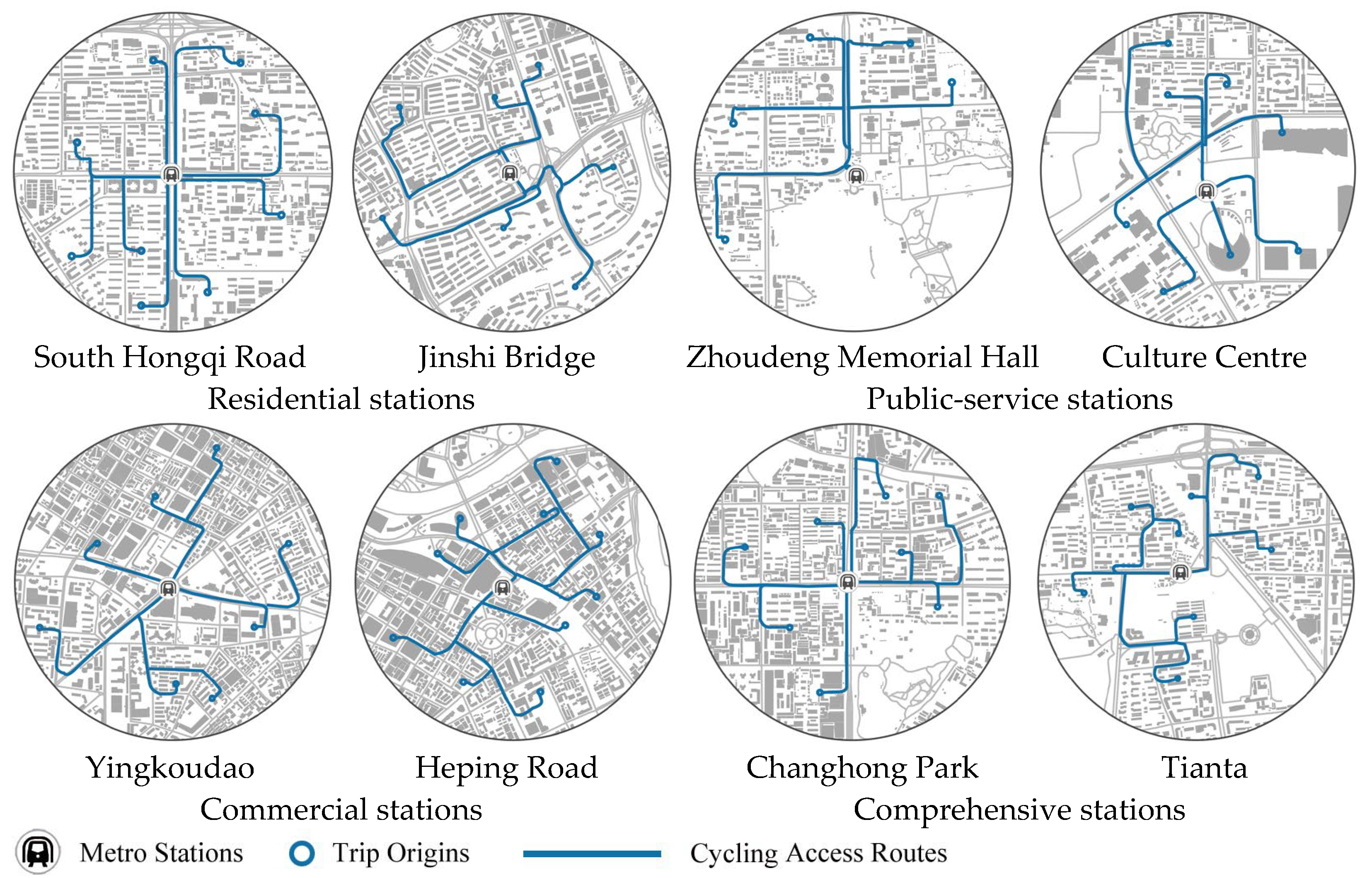
| Criteria | Indicators | Residential Station | Public-Service Station | Commercial Station | Comprehensive Station | ||||
|---|---|---|---|---|---|---|---|---|---|
| South Hongqi Road | Jinshi Bridge | Zhoudeng Memorial Hall | Culture Centre | Yingkoudao | Heping Road | Changhong Park | Tianta | ||
| Accessibility | Width of bike lanes | 2.24 | 2.37 | 2.31 | 2.29 | 1.77 | 1.79 | 2.19 | 2.25 |
| Bicycle route directness | 1.51 | 1.64 | 1.67 | 1.50 | 1.44 | 1.50 | 1.58 | 2.05 | |
| Degree of interruptions | 0.29 | 0.27 | 0.33 | 0.32 | 0.37 | 0.39 | 0.30 | 0.34 | |
| Safety | Percentage of bike lanes | 71.88 | 45.57 | 83.27 | 46.63 | 53.99 | 57.09 | 75.26 | 69.23 |
| Percentage of protected bike lanes | 59.67 | 7.44 | 52.93 | 14.55 | 12.30 | 13.65 | 50.65 | 20.27 | |
| Encroachment of bike lanes | 2.20 | 2.88 | 2.18 | 2.55 | 3.62 | 3.28 | 2.96 | 2.85 | |
| Percentage of bicycle routes disturbed by motor vehicles | 18.96 | 17.56 | 16.96 | 14.84 | 15.07 | 14.34 | 18.68 | 22.82 | |
| Density of entrances and exits | 0.61 | 0.67 | 0.50 | 0.55 | 0.87 | 0.77 | 0.97 | 0.87 | |
| Convenience | Density of bicycle parking spots | 0.44 | 0.45 | 0.46 | 0.43 | 0.37 | 0.33 | 0.38 | 0.36 |
| Route guide signs | 1.82 | 2.50 | 2.78 | 3.21 | 2.88 | 2.73 | 1.87 | 1.80 | |
| Density of daily service facilities | 7.25 | 7.36 | 6.49 | 5.41 | 9.82 | 11.04 | 8.18 | 8.77 | |
| Diversity of daily service facilities | 0.28 | 0.34 | 0.15 | 0.19 | 0.39 | 0.41 | 0.21 | 0.30 | |
| Comfort | Quality of bike lanes | 3.06 | 2.93 | 2.96 | 3.26 | 2.61 | 2.49 | 3.14 | 3.14 |
| Slope of bike lanes | 1.46 | 2.03 | 1.14 | 1.67 | 1.51 | 1.32 | 1.50 | 1.52 | |
| Cycling congestion | 2.58 | 2.74 | 1.97 | 2.54 | 2.89 | 3.47 | 2.24 | 2.65 | |
| Percentage of routes with street lamps | 85.75 | 81.04 | 91.80 | 85.33 | 95.25 | 94.14 | 84.22 | 89.02 | |
| Greenery | 13.74 | 15.19 | 18.95 | 15.98 | 20.49 | 19.30 | 10.82 | 11.36 | |
| Openness of vision during cycling | 28.29 | 23.56 | 27.66 | 25.72 | 16.19 | 15.85 | 27.34 | 24.26 | |
| Criteria | Residential Station | Public-Service Station | Commercial Station | Comprehensive Station | ||||
|---|---|---|---|---|---|---|---|---|
| South Hongqi Road | Jinshi Bridge | Zhoudeng Memorial Hall | Culture Centre | Yingkoudao | Heping Road | Changhong Park | Tianta | |
| Accessibility | 0.206 | 0.175 | 0.204 | 0.176 | 0.164 | 0.169 | 0.210 | 0.186 |
| Safety | 0.225 | 0.193 | 0.225 | 0.194 | 0.181 | 0.186 | 0.232 | 0.205 |
| Convenience | 0.066 | 0.058 | 0.068 | 0.059 | 0.055 | 0.056 | 0.070 | 0.062 |
| Comfort | 0.080 | 0.068 | 0.080 | 0.069 | 0.064 | 0.066 | 0.082 | 0.072 |
| Overall | 0.577 | 0.494 | 0.577 | 0.498 | 0.465 | 0.477 | 0.595 | 0.525 |
| Rankings | 2 | 6 | 2 | 5 | 8 | 7 | 1 | 4 |
| Residential Station | Public-Service Station | Commercial Station | Comprehensive Station | |||||
|---|---|---|---|---|---|---|---|---|
| South Hongqi Road | Jinshi Bridge | Zhoudeng Memorial Hall | Culture Center | Yingkoudao | Heping Road | Changhong Park | Tianta | |
| Scores | 39.445 | 39.032 | 43.244 | 35.423 | 34.667 | 34.098 | 42.010 | 35.004 |
| Rankings | 3 | 4 | 1 | 5 | 7 | 8 | 2 | 6 |
| Ranking changes | ↓1 | ↑2 | ↑1 | 0 | ↑1 | ↓1 | ↓1 | ↓2 |
Disclaimer/Publisher’s Note: The statements, opinions and data contained in all publications are solely those of the individual author(s) and contributor(s) and not of MDPI and/or the editor(s). MDPI and/or the editor(s) disclaim responsibility for any injury to people or property resulting from any ideas, methods, instructions or products referred to in the content. |
© 2025 by the authors. Licensee MDPI, Basel, Switzerland. This article is an open access article distributed under the terms and conditions of the Creative Commons Attribution (CC BY) license (https://creativecommons.org/licenses/by/4.0/).
Share and Cite
Yang, Q.; Zhang, Z.; Cai, J.; Ding, M.; Li, L.; Zhang, S.; Song, Z.; Wu, Y. Quality Assessment of Cycling Environments Around Metro Stations: An Analysis Based on Access Routes. Urban Sci. 2025, 9, 147. https://doi.org/10.3390/urbansci9050147
Yang Q, Zhang Z, Cai J, Ding M, Li L, Zhang S, Song Z, Wu Y. Quality Assessment of Cycling Environments Around Metro Stations: An Analysis Based on Access Routes. Urban Science. 2025; 9(5):147. https://doi.org/10.3390/urbansci9050147
Chicago/Turabian StyleYang, Qiyao, Zheng Zhang, Jun Cai, Mengzhen Ding, Lemei Li, Shaohua Zhang, Zhenang Song, and Yishuang Wu. 2025. "Quality Assessment of Cycling Environments Around Metro Stations: An Analysis Based on Access Routes" Urban Science 9, no. 5: 147. https://doi.org/10.3390/urbansci9050147
APA StyleYang, Q., Zhang, Z., Cai, J., Ding, M., Li, L., Zhang, S., Song, Z., & Wu, Y. (2025). Quality Assessment of Cycling Environments Around Metro Stations: An Analysis Based on Access Routes. Urban Science, 9(5), 147. https://doi.org/10.3390/urbansci9050147