1. Introduction
The number of people living in cities continues to grow [
1]; there are already more than eight billion people in the world and this number is expected to increase by several billion over the course of this century [
2]. The environmental costs of urban sprawl, the mobility patterns that are reproduced in cities and the dynamics of industrial production in their peripheries have led to profound social and economic transformations [
3]. But it is also urban spaces that can serve as engines for change towards more sustainable and resilient local, regional and global horizons [
4] provided that multiple disciplinary approaches are incorporated [
5,
6]. As cities seek to strike a balance between expected economic growth and the pursuit of necessary social equity, multidisciplinary urban planning presents itself as a vital tool to alleviate territorial inequalities, while promoting the pursuit of spatial and social justice [
7].
In the context of an intervention project for the renaturalisation of the urban space of the city of Pontevedra (Galicia, Spain), this research pursues a better understanding of how the population experiences and values urban space according to their place of residence and socio-demographic characteristics, taking into account that territories are configured as places that generate not only construction and production, but also experience and rootedness [
8].
Pontevedra, a medium-sized Spanish city, is a pioneering example of urban regeneration. This project aims to evolve the current model of the urban transformation of Pontevedra by promoting the environmental dimension, through the renaturalisation of urban space, increasing biodiversity and recovering the connectivity of the maritime and fluvial space.
The aim is to increase urban resilience to climate change by strengthening local green infrastructure and improving ecosystem services and the connection between urban and peri-urban natural areas in Pontevedra. The project has two main objectives: (1) to renaturalise five urban spaces and (2) to design a strategy for a sustainable city with a green infrastructure network.
This study is grounded in the concepts of spatial justice and renaturalisation. Spatial justice, as articulated by Soja [
7], emphasises the importance of equitable urban planning to address socio-spatial inequalities, while renaturalisation [
6] focuses on the integration of natural systems into urban areas to promote sustainability and resilience. Together, these frameworks provide a foundation for understanding how urban interventions can balance ecological and social priorities to foster inclusive and sustainable cities. The equitable distribution of green spaces, a core component of spatial justice [
7], is critical to ensuring that all residents benefit from renaturalisation efforts aimed at enhancing urban resilience [
6]. By linking spatial justice and renaturalisation, this study contributes to the broader discourse on urban sustainability, demonstrating how these frameworks can guide policies to reduce socio-spatial inequalities.
This paper, therefore, contributes to the debate on spatial justice [
9,
10] by providing empirical evidence on how personal circumstances influence satisfaction with and use of the city. It also provides a framework for assessing how citizen participation can be an effective mechanism for promoting equity in access to urban resources [
11,
12]. By providing practical implications, it seeks to contribute to the improvement of urban policies, advocating for the reinforcement of a sense of belonging and social cohesion through green spaces. Space being a social product, it must also be a political responsibility, i.e., if it is produced, we must pay attention to how it is produced [
13], considering the political spatiality of the territory [
7].
To address the objectives of this study, a quantitative methodology based on the use of various statistical techniques was employed. Factor analysis allowed the identification of latent dimensions of satisfaction and urban perception, simplifying a broad set of variables into key factors such as social cohesion, sustainability and spatial maintenance. Subsequently, cluster analysis segmented the population into homogeneous groups according to their valuation patterns and socio-demographic characteristics. In addition, multiple linear regression and ANOVA analyses were applied to assess the relationships between independent variables (age, income, educational level and territorial area) and the extracted dimensions, providing a comprehensive view of the interactions between citizen perceptions and contextual characteristics and thus providing a more complete picture of urban planning in the context of intra-urban inequalities [
14] that enable climate injustice in cities [
15].
Why is it important to analyse how the resident population values these spaces? Well, because understanding population clusters, framed within a critical analysis of the valuation of urban spaces [
13], will reveal citizens’ perspectives and, with them, their influence on urban planning decisions. In this sense, incorporating the citizens’ perspective can condition the success or failure of interventions in public spaces [
16,
17], as well as promote adjustments that ensure a more inclusive and equitable urban design. In other words, knowing residents’ opinions facilitates the promotion of urban development that responds to the real needs of the population living in the city.
The conditions that make it possible for the city to be the space where differences and contradictions come together: for certain groups, classes or people, for certain ideas, thoughts and opinions, not to be segregated or pushed aside or sent to the peripheries, no longer of the city, but of urban life [
18] (p. 160).
In this way, it will be possible to understand which inhabitants have greater access to and enjoyment of urban spaces and which experience barriers derived from their urban spatial vulnerability.
To account for this, the specific objectives of this research are to evaluate citizen perceptions, analysing how the socio-demographic characteristics of the population influence the valuation of urban spaces in Pontevedra, highlighting possible territorial and social inequalities.
This research highlights the importance of linking spatial justice with sustainable planning practices, as suggested by Soja [
13], to ensure equitable access to urban opportunities while promoting environmental resilience.
Our analysis also supports Anguelovski et al. [
15] argument that renaturalisation efforts must prioritise equity to avoid exacerbating territorial inequalities and climate injustices.
In addition, Harvey’s [
19] concept of the ‘right to the city’ provides a framework to understand how citizen participation in urban planning processes can mitigate the socio-spatial divides highlighted in our findings.
By addressing disparities in access to green spaces and sustainable mobility, this study aligns with broader calls for urban ecological balance, emphasising the interdependence of spatial justice and environmental sustainability [
20,
21].
So, despite the growing body of research on spatial justice and renaturalisation, most existing studies rely on qualitative approaches limiting their ability to systematically quantify public perceptions of urban transformation. This study addresses this gap by integrating factor analysis and cluster analysis to empirically assess socio-spatial inequalities in urban environments. This methodological framework allows for the identification of distinct patterns in public satisfaction and urban space usage, offering deeper insights into how demographic and territorial factors influence perceptions of renaturalisation. The integration of these statistical techniques represents an innovative contribution, bridging the gap between theoretical discussions of spatial justice and empirical urban policy design.
2. A Theoretical Approach to Renaturalisation and Spatial Justice: Towards Inclusive and Sustainable Urban Planning
The relationship between the built and the natural is not static; space is reinvented to configure new naturalised urban scenarios. In the city, we find a landscape mostly made up of buildings—industrial, residential and service buildings—connected by impermeable surfaces largely dedicated to road traffic, i.e., conventional civil engineering that performs mostly individual and single-purpose functions [
22]. On the contrary, green infrastructure brings a wealth of ecosystem benefits, as well as a multifunctional character and an openness to multidisciplinarity to reconfigure anthropogenic habitats [
16]. Specifically, green spaces in the city contribute to improving the health of populations [
23,
24,
25,
26], mitigate the effects of climate change, increase biodiversity [
27] and are configured as spaces for social relations [
28].
While it is true that in urban contexts nature cannot be pristine or alien to anthropic action, it is a more or less ecological and/or sustainable construction that is on the plane of the symbolic and is defined by the interaction of the community, the political sphere and aesthetic perception. In this sense, the processes of renaturalisation seek to introduce the citizen perspective to reimagine the urban landscape collectively and in connection with nature [
22], through recovery, regeneration, the creation of ecological corridors and the creation of new and varied functions for underused or abandoned spaces [
17]. Some strategies that destabilise these dualities stem from cultural ecosystem services, where relational processes between actors help to connect dimensions—physical, semiotic and social—in the process of renaturalisation, raising “the public awareness on the need to protect urban nature transformed by human-nature interactions” [
29] (p. 12).
2.1. A Theoretical Approach to the Urban Paradigm
Infrastructure overproduction, gentrification, sprawl, area degrowth, mobility and territorial inequality are not homogeneous, but present specificities that require adaptive approaches and need to be addressed by planning [
30].
Given the exponential increase in the world’s population, coupled with new energy sources, it is suggested that metropolitan expansion will take a centrifugal form [
31]. The trend of emptying the countryside to concentrate the population in the cities will probably be reversed, not with the idea of returning to the countryside, but with the intention of a uniform population distribution, differentiating industrial/labour and residential purposes [
31]. This urban transition on a global scale, accompanied by the “imbalance in population distribution will be accompanied by an increasing gap in the distribution of wealth” [
32] (p. 25).
Even so, it is worth noting that, although ”the contradictions and conflicts inherent to a class society manifest themselves almost exclusively in the city, this does not mean that their origin must automatically be sought in the city’ [
33] (p. 102). In fact, the definition of what constitutes the urban unit can only come from the theoretical level [
34] and, therefore, we cannot understand the urban only in opposition to the rural. A standardised definition of the urban unit cannot be established since there is no demarcation of shared limits or compatibility of data, for example, in terms of the population density or size—among other indicators for measuring levels of urbanisation [
30]—. We are facing extended forms of regional urbanisation, resulting in the construction of megalopolises arising from suburbanisation, the metropolitanisation of territories and infrastructural and residential decentralisation [
35]. “The urbanisation of the world is a kind of exteriorization of the inside as well as interiorization of the outside” [
36] (p. 474).
We must turn our attention to circulation, for the urban phenomenon is at the confluence of the city’s functions; urban centres cover a given territory with networks of administration and domination, but the city itself is an integral part of the networks of production and distribution that administer and dominate it—because it is dominant and to the extent that it is dominant [
37]—.
2.2. Urban Injustice and the Right to the City
Spatial justice, as defined by Soja [
7], refers to the equitable distribution of urban resources and opportunities, ensuring that all individuals, regardless of their socio-economic status, have access to the benefits provided by urban environments. This concept underlines the intersection of spatial inequalities with broader socio-economic disparities, highlighting the need for urban policies that prioritise inclusivity and fairness in resource allocation. Renaturalisation, according to Lehmann [
6], is the process of reintroducing natural elements, such as green spaces and ecological corridors, into urban environments to enhance both ecological resilience and social well-being. This approach seeks to bridge the gap between built and natural environments, creating multifunctional spaces that address environmental challenges while fostering community interactions and connectivity.
Urban injustice manifests itself in a variety of ways; opportunities, quality of life and well-being, health and access to urban resources are unequally distributed among the population living in an urban space [
7]. Social inequalities—subject to relations of power and domination—are intrinsically linked to spatial inequalities, which is why it is at this intersection that spatial injustice appears [
7]; “in all constructions there is an implicit meaning, a generative idea that space must serve” [
38] (p. 20).
The right to the city, is “a common rather than an individual right since this transformation inevitably depends upon the exercise of a collective power to reshape the processes of urbanisation” [
19] (p. 23). Citizens must play an active role in both the design and planning of their cities, becoming agents of change that can contribute to mitigating spatial injustice, generating new forms of urban appropriation and resistance and of transformation according to their needs, concerns and uses [
7].
Applying this vision to urban planning for renaturation implies a conscious approach to equity in access to public services and infrastructure, so that all inhabitants can benefit from urban development. A democratic planning system [
39] co-creates with the local community to result in a progressive and holistic approach to regeneration [
40]. Meanwhile, it is true that community participation must be representative of all social strata, especially the socially excluded [
16]. Both individuals and collectives have the right to claim a democratic use of city space and to reclaim their role as central actors in shaping it [
19]. Thus, the process does not only respond to the order of the individual; social movements actively participate in the transformation of space, since it is the product of social interactions [
41]. They emerge trying to overcome isolation and acting differently from corporate capital, real estate developers—supported by financial capital—and the state, which is enmeshed in the logic of business [
19].
Under this paradigm, citizen participation becomes an essential instrument to fight against urbanisation processes that directly or indirectly deprive citizens of their decision-making capacity [
21]. For this reason, it cannot be a process that is imposed vertically and from above, but must start from the basis of those who inhabit the space, who live and experience it and who, therefore, produce and change it; the community must be involved in the creation of multifunctional green spaces [
42].
However, this is not without its problems; some of the obstacles to incorporating citizenship include accessibility to participation, governance barriers, sustaining engagement, integrating different attitudes and life circumstances, skills, knowledge, support and resources [
39]. As well as the cost and complexity of implementing nature-based solutions in a compact space with dense grey networks [
16], in the cases of industrial green infrastructure, what we find are that the biggest barriers for residents are cost overruns and a lack of political support and maintenance [
17]. In short, it must be kept in mind that the processes of urbanisation, construction and urban transformation are originally processes of social imagination [
43], which are conditioned into praxis by the context in which they take place.
2.3. The City on a Human Scale: Satisfaction, Appreciation and Intervention in Urban Public Space
Satisfaction with social and physical space, in this case, urban space, significantly influences the perception of happiness [
44], which is a key indicator when assessing subjective well-being [
45]. Regarding the relationship between happiness and satisfaction with surrounding life and greenery, socio-demographic variables are the determinant, highlighting that increasing green space alone is not enough, but must be accompanied by the needs of citizens—quality and integrated amenities [
46]—. For example, an analysis of 60 countries around the world (a comparison between those with the highest and lowest GDP) finds that for those with the lowest GDP, green space is not positively correlated with happiness. However, when GDP reaches a certain threshold, green spaces become important and are positively correlated with happiness as they are spaces for social relations and support [
47].
While it is true that the difficulties associated with urban life—lax and complex social networks that produce loneliness and alienation, the sharp differences between the rich and poor, stress, competition, sensory overload or overcrowding—are shared and more palpable in processes of rapid urbanisation, the “urban malaise” does not manifest itself in all cities in the same way, as each one—very dependent on where it is located territorially—presents its own challenges and dangers [
48]. Thus, human well-being is related to the level of satisfaction with the space one inhabits; the positive valuation of an urban space that responds to the needs of residents is the path to the general well-being of populations [
44,
45,
48,
49].
In this way, the analysis of satisfaction becomes an essential component in assessing the effectiveness of urban intervention and its capacity to bring about positive social change. It should be noted that subjective well-being, while related to the socio-economic status, in modern societies is more closely related to the socio-emotional status [
45]. For example, lower values of the average well-being are found in gender-segregated societies than in those with high income disparities, “inequality hurts only when it interferes with the gratification of basic needs, such as our need for food or respect” [
45] (p. 52).
It is, therefore, essential to understand how the resident population interprets, perceives and remembers urban space; cities must be legible, i.e., easily understood by the people who live there [
49]. An environment that is legible facilitates psychological well-being, as it allows people to feel safe in their space and find their way around it, to use it. A legible space will be a well-valued space, and a well-valued space will result in greater satisfaction and thus greater subjective and objective well-being. The importance of legibility can again be linked to green spaces, since, taking into account that staying in green spaces for more than 20 min is linked to higher subjective well-being, in order for the time spent in such a space to be long enough, they must be attractive and hold the attention of the visitor; therefore, they must be understandable to the user and linked to his or her needs [
16].
Jan Gehl introduces a novel approach that focuses on people, what he will call the ‘human scale’ [
50]. He argues that urban planning should focus on creating liveable and sustainable cities, always from the perspective of the pedestrian, moving away from a focus on road traffic-centred infrastructure and putting policies for the quality of life of the inhabitants at the centre. The city must foster social interactions, ensuring that the routine needs of the people who live there are met and listened to when planning new spaces or intervening in existing ones. The meaning of streets, squares and parks is that they are used and enjoyed by the resident population. It is necessary to encourage the use of public spaces as a way of fostering greater social cohesion and promoting collective and individual well-being.
3. Methodology
This quantitative study analyses the satisfaction of the resident population of Pontevedra with their immediate urban environment. To do so, several statistical techniques will be used to clarify the synergies between the socio-demographic characteristics of the resident population and their knowledge of the city, as well as their subjective assessment of it. All of them use data extracted from a survey with a sample of 201 people, representative of the 69,697 people, aged 18 and over, resident in the city of Pontevedra in 2023. Sex and age quotas were established in proportion to each territorial area studied and the sampling process used was simple random. The data were treated following quality control processes—occupational structure—by correcting the detected biases with weighting variables. With a 95% confidence level, our sample provides an acceptable margin of error of approximately ±4.4%, which is within the range used in similar urban studies.
Starting from the population structure of the Pontevedra City Council, according to the Municipal Population Register for the year 2022, we calculated the sample size and designed the sampling procedure (
Table 1) based on the establishment of quotas for sex and age group, proportional to the reference population of each Territorial Area. The population universe (≥18 years) is 69,697 people. We subdivided this population into the three areas studied, based on the section, which resulted in the following demographic structure by sex and age in each of them.
The reference territory, the municipality of Pontevedra, for the purposes of this survey, was subdivided into three types of spaces. On the one hand, all the sections of what we call the compact city, which include all the sections that have high values of density and continuity. On the other hand, three corridors that showed discontinuities, but also registered high population density and space occupation. These are the sections of the Ring (Monteporreiro, Estrada de Santiago and Corredor de Marín). Finally, we included the rest of the sections in a group that we call Rurururbano, in which densities drop significantly, and the fabric is discontinuous and/or atomised.
To solve our main objective, we worked with 8 aspects that residents rated from 0 to 10 about the city. The eight aspects rated by residents—pedestrianisation, cleanliness, safety, green spaces, streets, mobility, neighbourhood and general satisfaction with the city—were carefully selected based on their relevance to urban quality of life, spatial justice and sustainability. These eight aspects were chosen because they collectively capture the key dimensions of urban life that influence residents’ well-being, spatial justice, and sustainability. They reflect both the physical infrastructure (e.g., streets, green spaces and mobility) and the social and experiential qualities (e.g., safety, neighbourhood cohesion and general satisfaction) of the urban environment. By focusing on these aspects, this study aims to provide a comprehensive understanding of how different factors contribute to urban satisfaction and how they vary across demographic and territorial groups.
This study employs a 0–10 Cantril rating scale to assess urban satisfaction, a widely used approach in social sciences and urban studies [
51,
52,
53]. This scale allows respondents to express a broad spectrum of opinions, from extreme dissatisfaction (0) to extreme satisfaction (10), offering greater granularity than smaller scales or semantic Likert scales. This permits more clarity, ensuring reliable responses, minimising cognitive bias and enhancing comparability across different socio-demographic groups. Additionally, its continuous structure allows for a more nuanced assessment of public perceptions, essential for identifying patterns in urban space valuation. Prior research has demonstrated the effectiveness of this scale in evaluating subjective perceptions of urban environments, as it facilitates statistical analysis, including mean comparisons, regression models and factor analysis. Furthermore, by using the same scale for all variables we avoid having to resort to statistical normalisation.
The ratings for these aspects were analysed using factor analysis to identify latent dimensions of urban satisfaction such as social cohesion, sustainability and maintenance. These dimensions were then used in cluster analysis to segment the population into homogeneous groups based on their patterns of satisfaction and socio-demographic characteristics. The results of these analyses provide valuable insights into the factors that influence urban satisfaction and highlight areas for targeted policy interventions.
The socio-demographic control variables are age (three age groups: 18–39; 40–64; 65 and over), sex (differentiating between men and women), level of education (no schooling or primary education; compulsory; post-compulsory and university education), income (net annual income: less than 15,000; 15,000–20,000; 20,000–25,000; 25,000–30,000), social class (differentiated into manual, intermediate and services following Goldthorpe’s scheme) and place of residence (compact city (with high density and continuity), ring (compact peripheral development and high population density) and rururban (low-density and atomised or discontinuous fabric)). In addition, we worked with frequency of use of green spaces, measured as the average number of days per year that each space studied is visited.
In order to know the use, an estimator has been elaborated that indicates how many times a year, on average, each citizen uses each of the spaces—visit, transit and destination—. Let
be the frequency of each case,
the time and
the total number of people who responded to the survey.
The estimator was applied to survey data to calculate the average annual usage of green spaces for each respondent. This metric was then used as an independent variable in statistical analyses (e.g., multiple linear regression, ANOVA) to assess its relationship with satisfaction levels, socio-demographic factors and territorial characteristics. The results of these analyses provide insights into how green space usage patterns vary across different population groups and how they influence perceptions of urban spaces.
We also use an indicator of health. This index is derived from the response to three items related to the health of the respondents. These variables were constructed using the same wording and scale used in the European Health Survey (EHSS). Two of them are objective data: the consumption of medicines in the last 15 days (C) and consultations with medical professionals in the last 4 weeks (M). The other indicator is subjective and refers to the perception of the state of health (P). The constructed indicator allows an interpretation from 0 and 100, and can be expressed as:
In the denominator of the previous formula, the difference between the maximum value achievable in the three variables analysed and the minimum possible is calculated, so that the index oscillates between 0 and 100.
The methodological strategy begins with a factor analysis to simplify and reduce the set of variables analysed. This allows them to be grouped according to their similarity, based on similar patterns of responses. The new factorial variables generated will allow us to work with classification techniques (Cluster Analyses), ANOVA or Linear Regression, to characterise socio-demographic profiles that characterise the different population groups according to their ratings. To measure the suitability of these methods, the usual indicators are used: KMO and Bartlett’s of Sphericity for Factorial, and VIF test and Determinant Coefficient for Regression.
Although these methods are widely established in urban research, their combined application in assessing perceptions of spatial justice and renaturalisation is a novel contribution. This integrated approach allows for a comprehensive understanding of how social, economic and spatial factors interact to influence urban satisfaction. Several studies have employed these techniques separately in urban planning and perception research [
50,
54,
55,
56], but this study advances the field by applying them collectively to examine socio-spatial inequalities and their impact on urban experiences.
To analyse the relationships between the study variables (knowledge of the space, use—measured in days per year—and satisfaction—again, on a numerical scale of 0–10—) and the independent variables, which would be the socio-demographic characteristics mentioned above, we used ANOVA and Multiple Linear Regression.
In short, the selection of the statistical techniques used is justified by the need to address, in a comprehensive manner, the complex interactions between the use of urban space, socio-demographic characteristics and levels of satisfaction/valuation of the city. In this sense, factor and cluster analysis is particularly useful, as it allows us to draw meaningful, concrete and more operational conclusions—if we want to understand the synergies between variables—from a large dataset. In turn, linear regression and ANOVA provide detailed insights into correlations and differences between different population groups.
The correlation analysis was conducted as an initial step to examine the strength and direction of relationships between urban satisfaction factors and socio-demographic variables, without implying causation. The insights gained from this analysis informed the subsequent regression model, which was used to establish predictive relationships by determining how independent variables influence urban satisfaction.
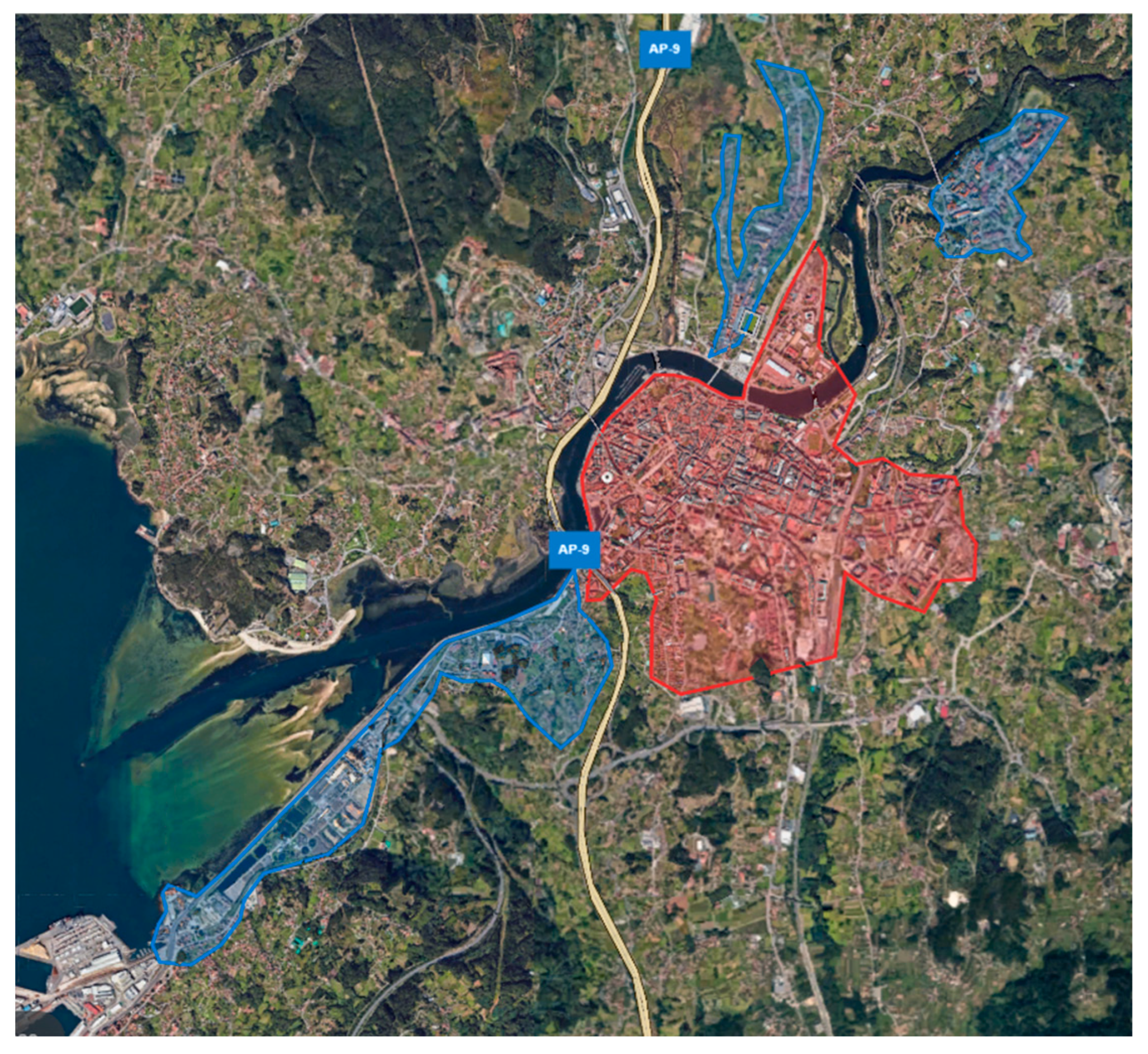
To facilitate the understanding of the territorial areas included in this study,
Figure 1 shows the geographical delimitation of the Compact City (in red), the Ring (in blue) and the Rururban area (uncoloured). These classifications are essential to analyse how territorial characteristics influence citizens’ perception of urban spaces.
4. Results and Discussion
The means and their standard deviation as well as the range of the responses obtained (theoretically possible from 0 to 10) are actually established for each variable in
Table 2. The means are all high, although the dispersion that marks the range shows a greater consensus in variables such as “general satisfaction with the city”, “the assessment of security” and with the “neighbourhood”. On the other hand, the greatest disagreement occurs when assessing “mobility”, with a high peak of standard deviation of the mean, which is reduced to the lowest value among the variables investigated.
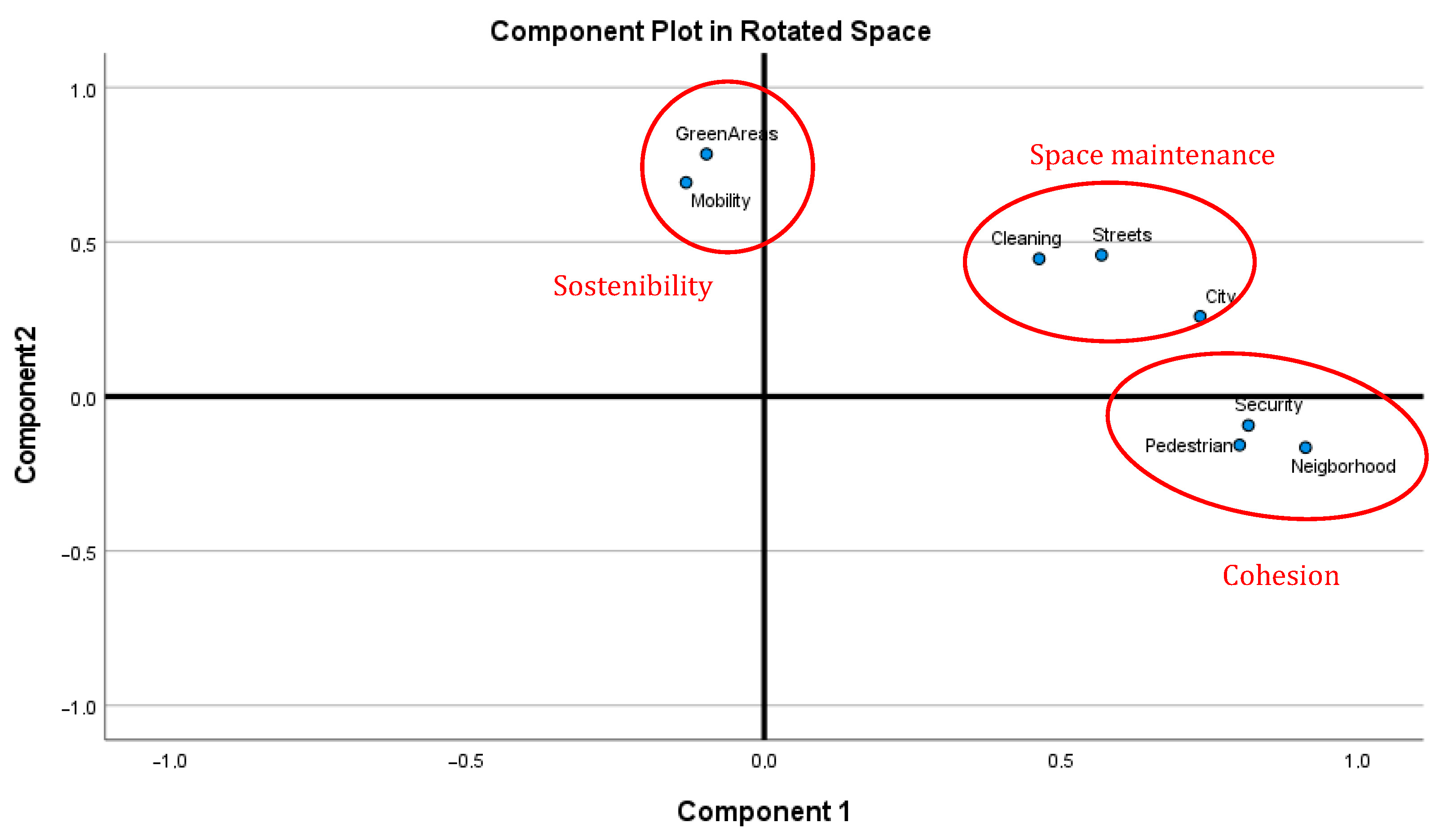
The factor analysis carried out in this research, through principal component analysis (PCA with a Promax rotation was used, which allows, as opposed to orthogonal rotation, the resulting factors to be correlated with each other; the point of this choice is that the variables are not completely independent, but interrelated), aimed to reduce the complexity of the data studied, specifically those related to the satisfaction variables, namely pedestrianisation, mobility, green spaces, streets, cleanliness, safety, neighbourliness and the state of the city in general (joint evaluation of all the items).
Through PCA it is possible to explain the variability in residents’ urban perceptions by identifying the underlying dimensions and then interpreting them in terms of socio- demographic profiles—cluster analysis—. The suitability of this technique is supported by a KMO of 0.8 and a significant Bartlett’s test of sphericity (<0.001). The analysis revealed two principal components—as shown in
Figure 2—which together explain 62.297% of the total variance for the urban satisfaction variables, the first of which explains 47.563% and the second, an additional 14.735%.
The first of these is made up of evaluation indicators linked to social cohesion and the maintenance of urban space and incorporates indicators such as neighbourliness (maximum load 0.843), an evaluation of the city in general (0.843), safety (0.777), pedestrianisation (0.736), cleanliness (0.649) and the state of the streets and public spaces (0.759). The second component is oriented towards green infrastructure, mobility and sustainability. It groups together the presence of green spaces (maximum load, 0.739), mobility strategies in the city (0.632), cleanliness (0.653) and the state of the streets and public spaces (0.712), with urban functionality standing out.
Finally, three groups of evaluations have been configured, one called “sustainability”, which reflects environmental awareness and its influence on satisfaction and quality of life in the city. Another is called “social cohesion”, which is more related to the social aspects of the urban space, and the last one is more related to well-being from the physical aspects, called “maintenance”.
The correlation coefficient between the components is 0.478, indicating that, although they address different dimensions of city perception—identified through three factors—there is, as we have already seen, an interrelation between them. In other words, social cohesion and the maintenance of urban infrastructure are not independent of sustainability and green infrastructure; rather, both dimensions contribute jointly to the satisfaction of the people who inhabit the space. Creating more pedestrian and green spaces, the better care of public infrastructure and prioritising urban safety would reinforce both dimensions. Therefore, cities should adopt a holistic approach that incorporates these aspects in an integrated manner [
25], to improve the overall perception of citizens and with it, their threshold of well-being [
45], while ensuring spatial justice [
7] and ecological balance [
57].
The factors extracted through factor analysis, such as ‘social cohesion’, ‘sustainability’ and ‘maintenance’, represent latent dimensions that summarise the population’s perceptions of key aspects of the urban environment. These factors become dependent variables in the regression analysis, allowing us to identify how socio-demographic characteristics (age, level of education, income and territorial area) influence these dimensions.
In
Table 3, we summarise the relevant results of the regression analysis for each key variable. On the one hand, the total percentage of variance explained in each model; in the next column, the variables that appear as significant in that model. Finally, the qualitative interpretation of the influence of that variable according to the sign and its interpretation in terms of the categories that compose it.
All VIF (Variance Inflation Factor) values are below, in the worst case, 2.5, so we can conclude that Multiple Regression is a suitable technique. The regression confirms the associations found in the factor analysis. It highlights how the territorial area and education shape perceptions of sustainability, while age and income affect social cohesion. The moderate correlation between the factors social cohesion and sustainability underlines the need to address them jointly. Urban policies that improve green infrastructure and sustainable mobility can also strengthen community interaction.
Thus, for the cohesion variable (24.8% of variance explained), some interesting relationships can be observed in relation to age and income. The older the age, the greater the perceived social cohesion. This may be related to greater attachment to the environment and greater participation in community social networks. The positive correlation between income and cohesion may be explained by access to higher quality urban spaces or greater involvement in activities that reinforce community interaction. These findings highlight the need to focus strategies on strengthening social cohesion in lower-income communities by designing, for example, accessible spaces that foster social interaction (e.g., neighbourhood parks).
Regarding the variable sustainability (7.7% of variance explained), it is observed that a higher educational level leads to a higher valuation of sustainability, possibly due to a higher environmental awareness. On the other hand, rural areas tend to value sustainability more highly, which could reflect a more direct connection with the natural environment or a lower perception of a negative urban impact. It would be necessary, among other aspects, to design specific educational campaigns in compact urban areas to increase environmental awareness, especially aimed at segments with lower educational levels. Furthermore, it would be necessary to consider improving accessibility to green spaces in urban areas, prioritising the connection of these spaces with the daily needs of citizens.
In relation to the maintenance of spaces (13.5% of variance explained), add that people living in rural areas are more concerned about the maintenance of spaces. This may be due to lower investment in infrastructure or a greater visibility of deficiencies in less urbanised areas.
Based on these findings, it should be added that, in order to improve the perception of sustainability, urban policies should target groups with lower educational levels and compact urban areas, where the perception is less favourable. Furthermore, it has been shown that the strong relationship between social cohesion and maintenance reinforces the idea that improving the physical state of urban spaces (cleanliness, streets) has a positive impact not only on the perception of quality, but also on the social fabric.
A Reading of the Valuation of the City in Social Terms
The correlation analysis has revealed the link between the satisfaction variables studied and the perception of the city as a whole. On the one hand, we know that the quality of streets and public spaces is a crucial factor in the positive perception of the city in global terms (r = 0.691), as well as community interactions (r = 0.608), the perception of safety (r = 0.535), pedestrianisation (r = 0.538) and cleanliness (r = 0.520). The synergies between the positive evaluation of the city and aspects related to sustainability, such as green spaces (r = 0.381) and mobility (r = 0.219), are not as strong. These variables are also interrelated, with cleanliness and the valuation of streets and public spaces being intrinsically related dimensions (r = 0.644) to perceptions of urban quality. Likewise, well-cohesive communities are associated with pedestrianisation (r = 0.597) [
58,
59] and tend to be perceived as safer (r = 0.587) [
60], achieving better values of well-being and perceived quality of life [
61].
To do this, we addressed a hierarchical cluster. The number of groups was decided by the parsimony criterion. According to it, the number is decided based on a reduction of less than 50% of the Within Groups variance. Once the synergies between variables have been established, it is necessary to indicate how the five clusters extracted from the cluster analysis have been configured, which can be consulted in
Table 4. These results are closely linked to the factors extracted, as the factor ‘social cohesion’ helped to identify the cluster ‘urban average’ and ‘cohesive peri-urban’. At the same time, the sustainability factor’s differentiated clusters such as ‘sustainable balanced’ and ‘outliers’—both with low ratings—and the maintenance factor highlighted perceptions of the quality of the physical environment, being relevant in the ‘resilient community’ cluster where this dimension is a priority.
Table 5 below shows the analysis of each cluster according to the socio-demographic variables.
The defining characteristics of the population in the “urban average” cluster are not easily identifiable, as this is the predominant profile with 65.5% of the cases; it indicates an intermediate consensus where no significant extremes are observed. It is characterised by values around 7 out of 10 for each of the factors: social cohesion (7.19), sustainability (6.81) and maintenance (7.06). No significant differences are found with respect to gender, and it is mostly made up of people over 40 years of age, with low/middle incomes and living in the compact city.
The so-called “cohesive peri-urban” cluster (8%) is characterised by higher ratings for social cohesion (8.13) and the maintenance of urban space (7.96), with lower positive ratings for sustainability (6.34). It is mostly made up of people under 40 years of age who do not live in the compact city, with post-compulsory education or less and an average income.
In the “sustainable balanced” cluster (16.5%), the factor averages are all above 7.5 (7.86 social cohesion, 7.77 maintenance and 7.60 sustainability). Slightly more variation is found in terms of gender, with women being represented in a slightly higher percentage. No differences are found in terms of age, but differences are found in terms of territorial variables (taking into account that most live in rururban areas or in the ring) and income, with the majority being middle/high income and with occupations in the service sector.
The ‘resilient community’ cluster (8.2%) has the worst average score for the sustainability factor (5.51), followed by maintenance (6.64) and achieving higher scores for social cohesion (7.54). In terms of age, it moves in extremes (under 40 or over 65) and is the group with the highest volume of people with no education or primary education, with average incomes and who are part of the manual and intermediate classes.
The “outliers” cluster is the smallest (1.5%) and represents an atypical group which, overall, has the lowest average score for the factors social cohesion (5.89) and sustainability (6.18). This profile suggests a higher dissatisfaction with social life (safety and neighbourliness) and sustainability (green spaces and mobility), with a moderate rating for the maintenance of streets and public spaces (7.18). It is mainly made up of people over 65 years old, living in the ring and without university studies, with low incomes and employed in manual work. Low social satisfaction, also linked to mobility and travel, may be indicative of a situation of social and economic vulnerability, with limited public resources in their area of residence.
In conclusion, the older we get, the lower the overall satisfaction with the social and sustainable dimensions (the “social cohesion” and “sustainability” factors) which may imply a mismatch between expectations and available services [
61]. In terms of the territorial area, the further away from the city centre, the higher the priority given to sustainability and mobility (the ‘sustainability’ factor) and the more compact areas with a younger population, the higher the rating of social aspects (the ‘social cohesion’ factor).
One issue that all clusters share is the lower rating of the sustainability factor (green spaces and non-pedestrian mobility) compared to the others. The low sustainability scores are due to a poorer assessment of green spaces, but especially of mobility. To improve the citizen’s view of the sustainability factor, it is necessary to holistically design peri-urban mobility programmes [
50,
58] and to improve public green spaces so that they are accessible to the entire population [
42], incorporating the population’s perspective in order to adapt to the needs of urban green areas [
22]. At the same time, it is necessary to observe differences according to age, adapting services to the needs of older populations [
62].
Thus, the integration of the factor and cluster analysis made it possible to identify how socio-demographic factors influence the perceptions of different population groups with more homogeneous ratings.
This is key to identify differentiated patterns of satisfaction and perception in the population, allowing for the targeting of specific urban interventions according to the needs of each group. Population segmentation shows how factors such as the educational level, income and territorial area influence the perception of the urban environment, providing an empirical basis for designing more equitable public policies. The characterisation of clusters allows the prioritisation of vulnerable groups and the establishment of targeted strategies, ensuring that urban policies are not only inclusive, but also effective in reducing inequalities.
The results confirm that spatial and social inequalities are deeply interconnected, manifesting themselves both in the valuation of sustainability and in the perception of social cohesion and urban maintenance. The variability in perceptions of green spaces and sustainable mobility between clusters highlights the need for interventions to ensure equity in access to key urban infrastructures.
Integrating these differences into urban planning will allow for more tailored solutions, ensuring that interventions respond to the specific priorities and barriers of each population segment.
The findings align with the principles of spatial justice [
11,
13] as they highlight how unequal access to urban resources perpetuates socio-spatial disparities that urban planning must address. Our analysis supports the notion of cities as dynamic spaces where infrastructure, governance and the community interact echoing the theories of urban resilience outlined by Anguelovski et al. [
15] and Fainstein [
12].
By identifying gaps in mobility and green space access, our study contributes to discussions on the ‘right to the city’ [
19,
37], emphasising the need for inclusive and democratic urban planning approaches.
The emphasis on enhancing sustainability and accessibility resonates also with smart city paradigms [
50] which advocate for integrating technology, community input, and environmental goals in urban development.
In addition, climate resilience strategies [
6] are particularly relevant to our findings as addressing sustainability gaps through green corridors and improved urban mobility directly contributes to mitigating climate change impacts on urban populations.
Consistent with spatial justice theories [
10,
13], the findings also demonstrate how territorial disparities in urban environments reflect broader systemic inequalities that urban policies must confront.
The observed correlations between social cohesion, sustainability and urban maintenance highlight the interdependence of these factors, supporting Massey’s [
11] assertion that urban space is both a social and political construct.
So, our findings align with smart city frameworks, as proposed by Gehl [
50], which emphasises the importance of prioritising pedestrian-friendly designs and accessible green spaces to foster liveable and sustainable urban environments. The low sustainability scores identified in this study are consistent with Anguelovski et al.’s [
15] findings which highlight the challenges of ensuring equitable access to green infrastructure in urban planning initiatives. Contrasting with traditional smart city narratives that emphasise technology-driven solutions, our results underscore the importance of integrating community perspectives into urban planning to address territorial disparities [
11].
The results contribute to climate-resilient urban planning frameworks by demonstrating how targeted investments in green infrastructure and sustainable mobility can mitigate climate vulnerability while promoting social cohesion [
6,
12].
This study diverges from traditional urban resilience theories by highlighting the interdependence of sustainability and social cohesion, suggesting that integrated interventions are crucial for fostering long-term urban well-being [
12,
19].
The findings highlight persistent sustainability gaps across clusters with limited accessibility to green spaces and suboptimal urban mobility identified as key challenges. Addressing these gaps requires the implementation of targeted strategies, such as increasing the availability of multifunctional green spaces and integrating them with public transportation networks.
In this sense, promoting active mobility (walking and cycling) and implementing eco-friendly public transportation systems can significantly contribute to improving urban sustainability. Case studies from cities like Copenhagen and Singapore, which have successfully integrated green infrastructure with sustainable transport solutions, offer valuable lessons for addressing these challenges. These examples underscore the importance of strategic investments in green infrastructure, mobility solutions and public engagement to foster sustainable urban development.
Cities should prioritise the creation of connected green corridors, ensuring that all residents have equitable access to green spaces within walking distance. Educational campaigns to raise awareness of sustainability issues, coupled with participatory urban planning processes, can ensure that interventions align with community needs and priorities.
5. Conclusions
This study contributes to the discourse on urban resilience [
6] by identifying how targeted interventions in green infrastructure and mobility can simultaneously address environmental and social inequities. The integration of social cohesion, sustainability and urban maintenance in our analysis underscores the holistic approach needed to balance ecological and social justice in urban planning [
12,
15].
Our findings also reveal that sustainability gaps, particularly in mobility and green infrastructure, reinforce socio-spatial inequalities, which must be addressed to achieve truly inclusive urban environments [
11,
50].
The findings of this study reveal significant territorial inequalities in urban perception and satisfaction. As the distance from the compact city increases, public space knowledge, usage and satisfaction decline, with mobility patterns playing a crucial role. Peripheral populations, especially those commuting by private vehicles, exhibit lower spatial awareness and engagement. The analysis highlights how these territorial disparities intersect with income and educational differences, reinforcing socio-spatial inequalities.
The factor analysis results confirm that social cohesion and urban maintenance are strongly linked to positive city perceptions. High-rated variables such as safety, cleanliness, and pedestrianisation contrast with sustainability concerns, which are largely shaped by mobility constraints. Addressing these disparities requires reconsidering urban mobility patterns to enhance sustainability and accessibility. If we want citizens’ assessments of urban space to be more positive in those areas in which they are most dissatisfied, we must rethink the pendular mobility patterns produced by productive dynamics [
31].
The cluster analysis further underscores the variability in satisfaction levels, identifying five distinct population segments based on their perceptions of social cohesion, sustainability and urban maintenance. Despite these differences, sustainability remains the lowest-rated factor across all clusters, emphasising the need for policy interventions to improve green space accessibility and sustainable transport options.
This study underscores the necessity of differentiated urban policies that respond to specific demographic and territorial characteristics. Addressing spatial inequalities requires an inclusive approach that integrates public participation in decision making [
7,
50]. Ensuring that interventions align with residents’ needs is essential for fostering a sense of belonging and promoting equitable urban development [
9,
19,
38,
41].
Moreover, this research highlights the broader implications of socio-economic and territorial disparities, not only in terms of access to urban spaces, but also in shaping perceptions of cohesion and sustainability. It is imperative to implement targeted public policies that address these structural barriers, particularly in peripheral and underprivileged communities where concerns over public space maintenance are more pronounced.
This analysis thus provides a good empirical basis for guiding future urban interventions. Integrating citizen assessments into planning processes will not only improve the quality of life of residents [
44,
45,
49], but also move towards a more inclusive, sustainable [
63] and resilient city in the face of today’s urban challenges. But all this is not possible without multidisciplinary teams [
5,
6] to ensure legal frameworks and redistributive policies, to fund projects in the most vulnerable areas and to guarantee equitable access to urban resources.
On the other hand, the methodology applied to this research can be extended to other spaces with similar urban challenges, considering similarities, but above all, differences and specific challenges [
48], for example, the size of the city. The correlation between social cohesion and sustainability in citizen perception is relevant in medium-sized cities, where territorial inequalities and peri-urban mobility are often common problems. Cities with these same characteristics could benefit from the creation of legible and participatively created public spaces for spatial justice [
7,
9,
10,
50]. For larger and more densely populated urban areas, integrating renaturation and NBS can be used as a strategy in the face of high levels of urbanisation and insufficient green infrastructure, as the results show that integrating citizen expectations into the design of spaces improves citizen perception, satisfaction and thus the threshold of well-being [
46,
47].
Although our methodology relied on robust quantitative techniques, qualitative methods such as interviews or focus groups could provide complementary insights, particularly in understanding the nuanced and subjective dimensions of residents’ perceptions.
Future studies could use qualitative methods to explore the underlying motivations and emotional connections that shape urban satisfaction and perceptions, potentially uncovering factors overlooked in purely quantitative frameworks. Integrating qualitative and quantitative approaches would allow researchers to triangulate findings, thereby offering a more holistic understanding of the intersection between socio-demographic characteristics and urban perceptions.
Future research should also explore the role of emotional and identity-based factors in shaping urban satisfaction. The relatively stable overall perception of the city suggests that beyond objective characteristics such as infrastructure and services, symbolic and cultural elements contribute significantly to residents’ evaluations. Localism, defined as the sense of belonging and connection to place, may influence satisfaction even in areas with identified deficiencies.
Understanding the interplay between urban transformation and place attachment is increasingly relevant, particularly in the post-pandemic context. The literature suggests that social and ecological factors, such as the length of residence, public space quality and neighbourhood social ties, impact place attachment. However, a balance must be maintained to ensure that local identity considerations do not overshadow critical unmet urban needs.
To capture these subjective dimensions, future research should integrate qualitative methodologies, including interviews, focus groups, participatory action research and perception-based mapping. Enhancing survey instruments to incorporate questions on emotional attachment, local pride and territorial identity could further refine urban perception analysis. Comparative studies between resident evaluations and external expert assessments could also help quantify potential local biases.
Addressing territorial inequalities requires targeted investment in underprivileged areas to improve access to essential urban services such as green spaces, mobility infrastructure and public amenities. Enhancing the connectivity between peripheral and central urban zones is crucial, with a focus on public transportation systems, pedestrian-friendly infrastructure and policies that foster economic integration.
Policy interventions should prioritise the equitable allocation of resources with particular attention to marginalised communities to bridge gaps in access to urban opportunities and ensure spatial justice. Strategies such as the development of mixed-use areas in peripheral regions and the creation of ecological corridors can foster more inclusive urban spaces and mitigate the socio-spatial divide.
Urban policies should aim to decentralise investments, reducing reliance on compact urban centres and enabling balanced growth across all territorial areas. To address the gaps identified in this study, urban planning initiatives should adopt a dual approach: strengthening infrastructure in peripheral areas while improving accessibility to the compact city through multimodal transportation systems.
By connecting peri-urban zones with central areas, cities can promote not only physical mobility, but also economic and social inclusion. Future research should assess the impact of these interventions to ensure they effectively reduce territorial inequalities and foster more cohesive urban environments.
Finally, longitudinal studies tracking infrastructure changes and their impact on urban satisfaction would provide valuable insights into the effectiveness of urban interventions. Establishing key indicators based on the factors studied would enable continuous monitoring and adaptive policymaking, ensuring that urban development aligns with evolving community needs.

 ,
, 
