Discontinuities, Limits and Barriers: Quantifying the Intensity of Urban Spatial Ruptures
Abstract
1. Introduction
1.1. Anisotropy and Fragmentation of Space
1.2. Anisotropy in Urban Spaces
1.3. Discontinuities, Limits, and Barriers in Urban Space
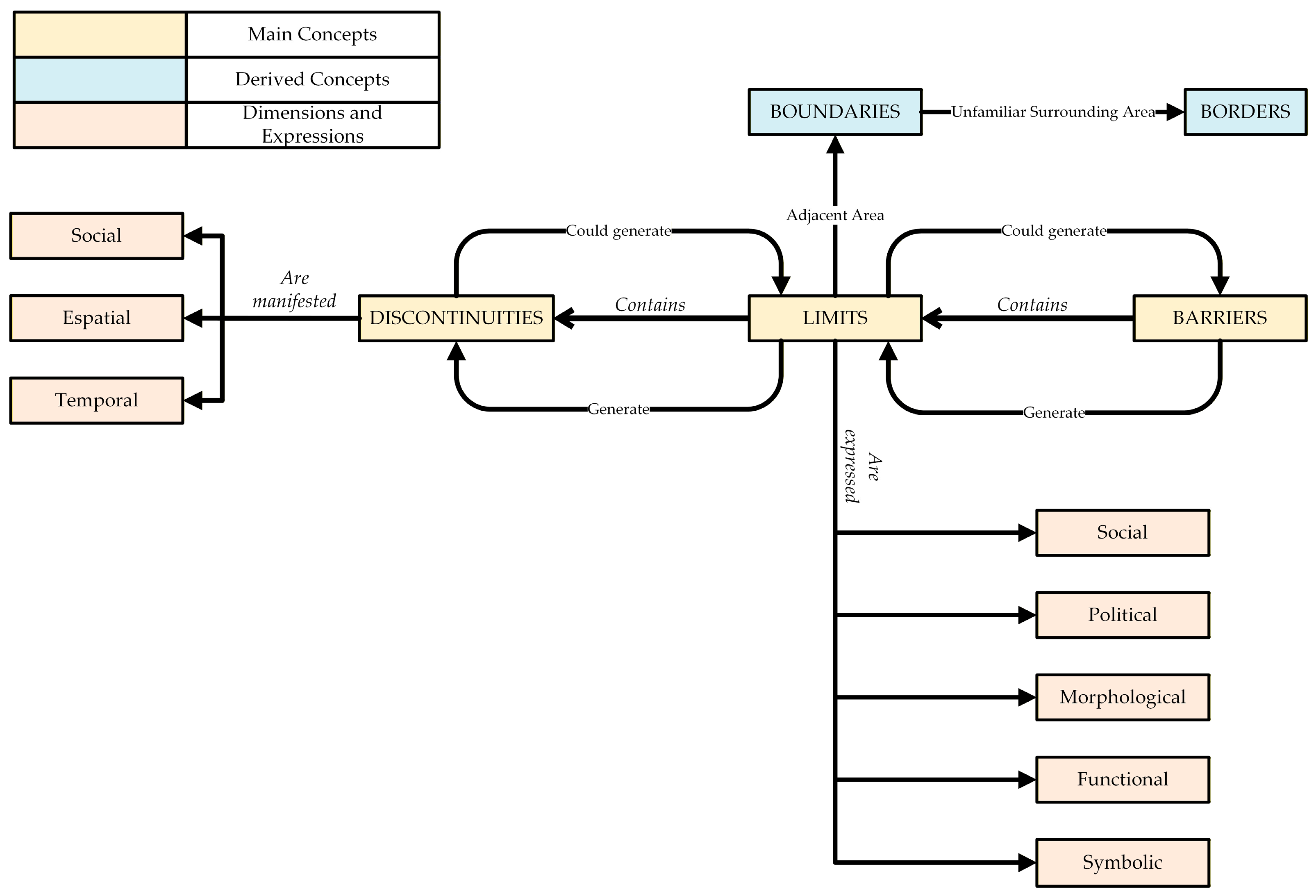
- Social Dimension. Because the processes of spatial division cannot be reduced to a single criterion, this dimension encompasses social characteristics such as age, socio-professional categories, origin and income. Each of these variables, taken individually and collectively, manifests in distinct ways and can produce its own discontinuities in spatial patterns.
- Spatial Dimension. This dimension captures the visible manifestation of fragmentation, where the spatial position and distribution of social groups within the city reveal distinct processes and variations. It encompasses the material dimension of urban form—expressed through the design, organization, and management of urban spaces—and may, in turn, influence the other dimensions [48].
- Temporal Dimension. In this dimension, discontinuities are no longer conceived as fixed snapshots but as evolving processes. They are closely tied to urban dynamics, with their expression changing through emergence, disappearance, or shifts in intensity over time. The persistence of discontinuities can therefore be seen as the result of significant transformations in their social or spatial dimensions.
- Social. Corresponding to patterns of residential segregation, this category relates directly to the logic of spatial differentiation along primarily social axes such as origin, education level, and income.
- Morphological. This category corresponds to the physical materialization of fragmentation. It includes spatial features such as topography, railways, highways, rivers, parks, and cemeteries, which often serve as the basis for residential separation strategies.
- Political. This category corresponds to the limits that define administrative units such as sectors, neighborhoods, and districts, within which specific territorial and political strategies are implemented.
- Functional. This category refers to limits that create gaps in mobility or reduce permeability between the different units that compose the urban fabric.
- Symbolic. This category encompasses the perceptions and representations that construct limits and shape residents’ spatial practices.
2. Materials and Methods
2.1. Research Objectives and Study Area
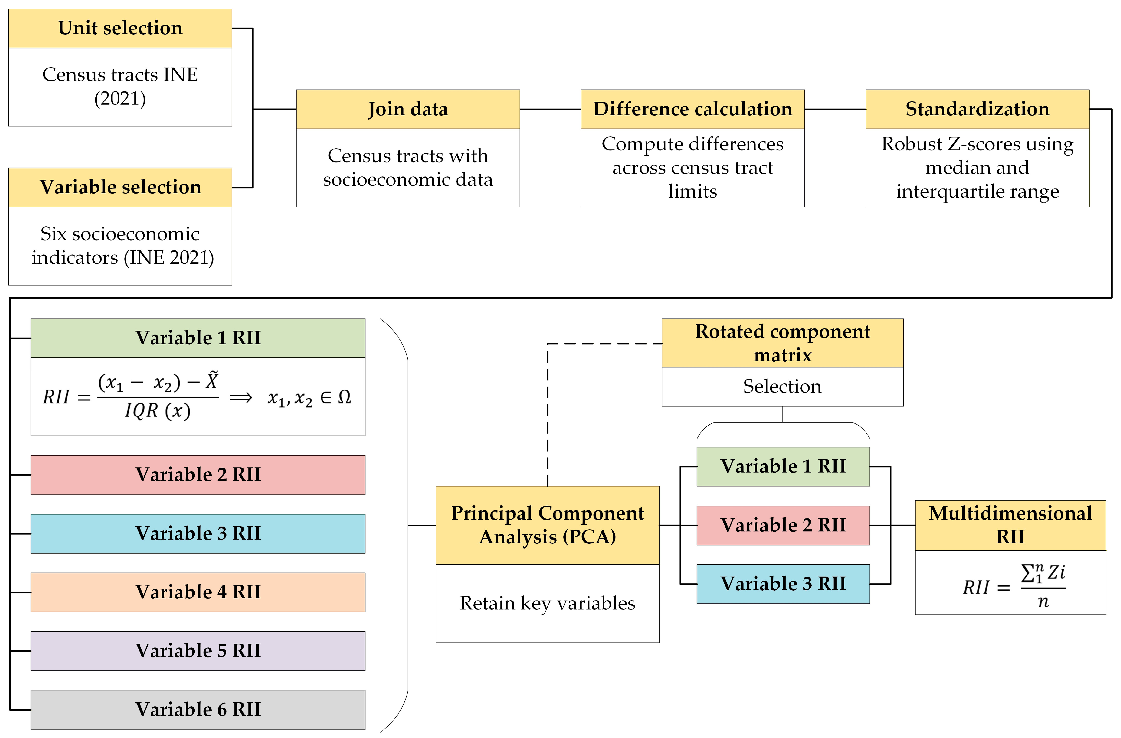
2.2. Selection of Variables
- % of population born abroad
- % of population without compulsory education
- % of population with higher education
- % of high-income population, with incomes above 160% of the average income of the urban area
- % of low-income population, with incomes below 60% of the average income of the urban area
- Mean income per consumption unit
2.3. Calculation of the Rupture Intensity Index (RII)
- Percentage of population with higher education, as it is the variable with the highest extraction value for Component 1.
- Percentage of foreign-born population, as it alone structures Component 2.
- Percentage of low-income population, as it alone structures Component 3.
2.4. Characterization of Limits
2.5. Comparative Methodological Positioning of RII
3. Results
3.1. The Nature of Urban Fragmentation in the City of Lleida
3.2. Fractures and Gradients in the Expression of Fragmentation in a Medium-Sized City
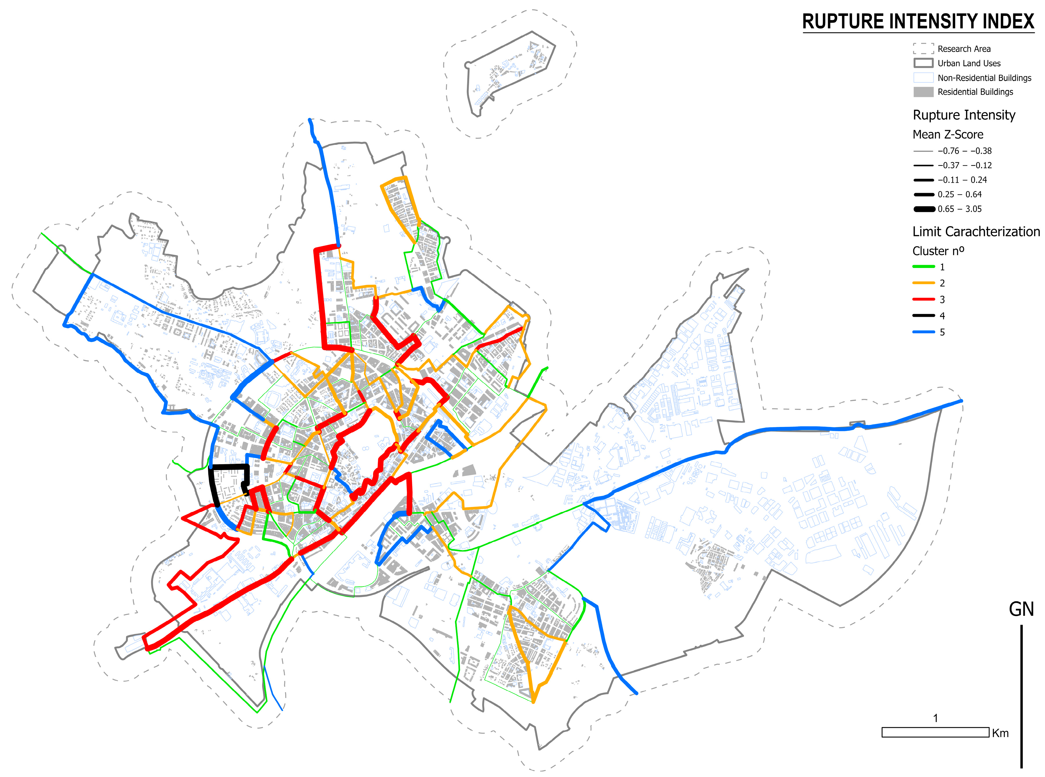
- Fracture lines, characterized by limits of deep intensity.
- Gradient areas, where discontinuities are expressed more gradually, as subtle permutations [39] that serve as transitions between two socioeconomic extremes.
3.3. Characterization of Limits and Their Expression in the City of Lleida
4. Discussion
4.1. The Study of Urban Fragmentation Through Limits
4.2. Potentialities and Limitations of the Proposed Method
5. Conclusions
Author Contributions
Funding
Data Availability Statement
Conflicts of Interest
Abbreviations
| RII | Rupture Intensity Index |
| MAUP | Modifiable Area Unit Problem |
References
- Di Méo, G.; Veyret, Y. Problématiques, enjeux théoriques et épistémologiques pour la géographie. In Limites et Discontinuités en Géographie; CDU SEDES: Paris, France, 2002; pp. 5–26. [Google Scholar]
- Jones, R. Categories, borders and boundaries. Prog. Hum. Geogr. 2009, 33, 174–189. [Google Scholar] [CrossRef]
- Bourdieu, P. Language and Symbolic Power; Thompson, J.B., Ed.; Polity Press: Cambridge, UK, 1991. [Google Scholar]
- Berger, P.L.; Luckmann, T. The Social Construction of Reality; Penguin Books: London, UK, 1966. [Google Scholar]
- Foucault, M. Discipline and Punish: The Birth of the Prison; Vintage Books: New York, NY, USA, 1995. [Google Scholar]
- Mark, D.M.; Freksa, C.; Hirtle, S.C.; Lloyd, R.; Tversky, B. Cognitive models of geographical space. Int. J. Geogr. Inf. Sci. 1999, 13, 747–774. [Google Scholar] [CrossRef]
- Tversky, B. Cognitive Maps, Cognitive Collages, and Spatial Mental Models. In Spatial Information Theory; Springer: Berlin/Heidelberg, Germany, 1993. [Google Scholar] [CrossRef]
- Trowbridge, C.C. On Fundamental Methods of Orientation and “Imaginary Maps”. Science 1913, 38, 888–897. [Google Scholar] [CrossRef]
- Tolman, E.C. Cognitive maps in rats and men. Psychol. Rev. 1948, 55, 189–208. [Google Scholar] [CrossRef]
- Piaget, J.; Inhelder, B. The Child’s Conception of Space; Routledge and Kegan Paul: London, UK, 1956. [Google Scholar]
- Capel, H. Filosofía y Ciencia en la Geografía Contemporánea, 2nd ed.; Ediciones El Serbal: Barcelona, Spain, 2012. [Google Scholar]
- Lynch, K. The Image of the City; MIT Press: Cambridge, MA, USA, 2008. [Google Scholar]
- Lowenthal, D. Geography, Experience, and Imagination: Towards a Geographical Epistemology. Ann. Assoc. Am. Geogr. 1961, 51, 241–260. [Google Scholar] [CrossRef]
- Wolpert, J. The Decision Process in Spatial Context. Ann. Assoc. Am. Geogr. 1964, 54, 537–558. [Google Scholar] [CrossRef]
- Jones, S.B. The Description of International Boundaries. Ann. Assoc. Am. Geogr. 1943, 33, 99–117. [Google Scholar] [CrossRef]
- Hartshorne, R. Geographic and Political Boundaries in Upper Silesia. Ann. Assoc. Am. Geogr. 1933, 23, 195–228. [Google Scholar] [CrossRef]
- Kristof, L.K.D. The nature of frontiers and boundaries. Ann. Assoc. Am. Geogr. 1959, 49, 269–282. [Google Scholar] [CrossRef]
- Newman, D. The lines that continue to separate us: Borders in our ‘borderless’ world. Prog. Hum. Geogr. 2006, 30, 143–161. [Google Scholar] [CrossRef]
- Newman, D.; Paasi, A. Fences and neighbors in the postmodern world: Boundary narratives in political geography. Prog. Hum. Geogr. 1998, 22, 186–207. [Google Scholar] [CrossRef]
- Piketty, T. Capital and Ideology; Harvard University Press: Cambridge, MA, USA, 2020. [Google Scholar]
- Musterd, S. Advanced introduction to urban segregation. In Elgar Advanced Introductions; Edward Elgar Publishing: Cheltenham, UK; Northampton, MA, USA, 2023. [Google Scholar]
- Van Kempen, R.; Murie, A. The new divided city: Changing patterns in European cities. Tijdschr. Voor Econ. En Soc. Geogr. 2009, 100, 377–398. [Google Scholar] [CrossRef]
- Duroudier, S. The Social and Spatial Divisions of Intermediate Cities in the United States. Espace Géographique 2014, 43, 134–147. [Google Scholar] [CrossRef]
- Musterd, S. Urban segregation: Contexts, domains, dimensions and approaches. In Handbook of Urban Segregation; Edward Elgar Publishing: Cheltenham, UK, 2020; pp. 2–17. [Google Scholar] [CrossRef]
- Dadashpoor, H.; Keshavarzi, S. Defining urban segregation: A qualitative meta-synthesis. Cities 2024, 149, 104947. [Google Scholar] [CrossRef]
- Haandrikman, K.; Costa, R.; Malmberg, B.; Rogne, A.F.; Sleutjes, B. Socio-economic segregation in European cities. A comparative study of Brussels, Copenhagen, Amsterdam, Oslo and Stockholm. Urban Geogr. 2023, 44, 1–36. [Google Scholar] [CrossRef]
- Yao, J.; Wong, D.W.S.; Bailey, N.; Minton, J. Spatial Segregation Measures: A Methodological Review. Tijdschr. Voor Econ. En Soc. Geogr. 2019, 110, 235–250. [Google Scholar] [CrossRef]
- Jacobs, J.M. The City Unbound: Qualitative Approaches to the City. Urban Stud. 1993, 30, 827–848. [Google Scholar] [CrossRef]
- Lindon, A. Geografías de la vida cotidiana. In Tratado de Geografía Humana; Anthropos: Mexico City, Mexico, 2006; pp. 356–400. [Google Scholar]
- Picó-Gutiérrez, V.; González-Ramírez, F.E.; Escudero-Gómez, L.A. From Segregation to Fragmentation: Mapping the Recent Global Literature. Urban Sci. 2025, 9, 98. [Google Scholar] [CrossRef]
- González Pérez, J.M.; Parreño Castellano, J.M.; Sánchez Aguilera, D. Fragmentación urbana. Macro conceptual para el análisis de la desigualdad en España. In XXVIII Congreso de la Asociación Española de Geografía; 2023; pp. 811–820. [Google Scholar] [CrossRef]
- Yu, P.; Yung, E.H.K.; Chan, E.H.W.; Wong, M.S.; Wang, S.; Chen, Y. An integrated approach for examining urban fragmentation in metropolitan areas: Implications for sustainable urban planning. J. Clean. Prod. 2023, 419, 138151. [Google Scholar] [CrossRef]
- Burgess, R. Segregación y fragmentación urbana: Algunos comentarios. Rev. Iberoam. De Urban. 2018, 14, 79–86. [Google Scholar]
- Helbrecht, I. The Creative Metropolis: Services, Symbols and Spaces. Int. J. Archit. Theory 1998, 3. [Google Scholar]
- Hendriks, F.; Hendriks, F. The Post-Industrialising City: Political Perspectives and Cultural Biases. GeoJournal 1999, 47, 425–432. [Google Scholar] [CrossRef]
- Navez-Bouchanine, F. La Fragmentation en Question: Des Villes Entre Fragmentation Spatiale et Fragmentation Sociale? L’Harmattan: Paris, France, 2002. [Google Scholar]
- Préteceille, E. La ségrégation sociale a-t-elle augmenté? Sociétés Contemp. 2006, 62, 69–93. [Google Scholar] [CrossRef]
- François, J.C. Ressemblances et proximités: Un point de vue sur le contexte théorique de la notion de discontinuité géographique. Cybergeo Rev. Eur. Géographie 2002, 241, 1–16. [Google Scholar]
- Le Goix, R. Sur le Front de la Métropole: Une Géographie Suburbaine de Los Angeles; Éditions de la Sorbonne: Paris, France, 2022. [Google Scholar] [CrossRef]
- Porcel López, S. Desigualdad Social Y Segregación Residencial, Una Relación Compleja; Cáritas Española Editores: Madrid, Spain, 2020. [Google Scholar]
- Fan, C.; Myint, S. A comparison of spatial autocorrelation indices and landscape metrics in measuring urban landscape fragmentation. Landsc. Urban Plan. 2014, 121, 117–128. [Google Scholar] [CrossRef]
- Wei, Y.; Zhang, Z. Assessing the fragmentation of construction land in urban areas: An index method and case study in Shunde, China. Land Use Policy 2012, 29, 417–428. [Google Scholar] [CrossRef]
- Sorando, D.; Ariza de la Cruz, J. Cauces socioespaciales: La segregación y el arraigo en Madrid. Rev. Española Sociol. (RES)/Span. J. Sociol. 2018, 32, 190. [Google Scholar] [CrossRef]
- Hubert, J.-P. La Discontinuité Critique; Publications de la Sorbonne: Paris, France, 1993. [Google Scholar] [CrossRef]
- Roberto, E. The Spatial Proximity and Connectivity Method for Measuring and Analyzing Residential Segregation. Sociol. Methodol. 2018, 48, 182–224. [Google Scholar] [CrossRef]
- Brenner, N. New Urban Spaces: Urban Theory and the Scale Question; Oxford University Press: Oxford, UK, 2019. [Google Scholar]
- Mandelbrot, B.B. The Fractal Geometry of Nature; W. H. Freeman and Company: San Francisco, CA, USA, 1983. [Google Scholar]
- Pullan, W. Spatial Discontinuities: Conflict Infrastructures in Contested Cities. In Locating Urban Conflicts; Palgrave Macmillan: London, UK, 2013; pp. 17–36. [Google Scholar] [CrossRef]
- Ayala, L.S. De territorios, límites, bordes y fronteras: Una conceptualización para abordar conflictos sociales. Rev. De Estud. Soc. 2015, 53, 14–27. [Google Scholar] [CrossRef]
- Smith, B.; Mark, D.M. Ontology and Geographic Kinds. In Proceedings of the 8th International Symposium on Spatial Data, Vancouver, Canada, 12–15 July 1998. [Google Scholar]
- Smith, N. La Nueva Frontera Urbana. Gentrificación y Ciudad Revanchista, 1st ed.; Traficantes de Sueños: Madrid, Spain, 1996. [Google Scholar]
- Low, S.M. The Edge and the Center: Gated Communities and the Discourse of Urban Fear. Am. Anthropol. 2001, 103, 45–58. [Google Scholar] [CrossRef]
- Van Houtum, H.; Strüver, A. Borders, Strangers, Doors and Bridges. Space Polity 2002, 6, 141–146. [Google Scholar] [CrossRef]
- Wacquant, L. Las dos Caras de Un Gueto, 1st ed.; Siglo XXI: Buenos Aires, Argentina, 2015. [Google Scholar]
- Morales, E.R. Planned Socio-Spatial Fragmentation: The Normalisation of Gated Communities in Two Mexican Metropolises. Urban Plan. 2024, 9, 1–20. [Google Scholar] [CrossRef]
- Bandauko, E.; Arku, G.; Nyantakyi-Frimpong, H. A systematic review of gated communities and the challenge of urban transformation in African cities. J. Hous. Built Environ. 2022, 37, 339–368. [Google Scholar] [CrossRef]
- Bellet Sanfeliu, C. La producción de un barrio desfavorecido en los márgenes de una ciudad media: La Mariola (Lleida). Scr. Nova. Rev. Electrónica Geogr. Y Cienc. Soc. 2021, 25, 75–103. [Google Scholar] [CrossRef]
- McFarlane, C. One assemblage and critical urbanism. City 2011, 15, 204–224. [Google Scholar] [CrossRef]
- Institut d’Estadística de Catalunya (IDESCAT). Idescat. El municipi en xifres. Lleida (Segrià). Available online: https://www.idescat.cat/emex/?id=251207 (accessed on 24 September 2025).
- Bellet Sanfeliu, C.; Andrés López, G. Urbanización, crecimiento y expectativas del planeamiento urbanístico en las áreas urbanas intermedias españolas (1981–2018). Investig. Geográficas 2021, 76, 31–52. [Google Scholar] [CrossRef]
- Bellet Sanfeliu, C.; Lasala Fortea, J.; Andrés López, G.; Cebrián Abellán, F. Juntos pero separados: La segregación residencial en las ciudades medias españolas. Ciudades 2025, 28, 73–91. [Google Scholar] [CrossRef]
- Andrés López, G.; Bellet Sanfeliu, C.; Cebrián Abellán, F. Buscando límites a la urbanización dispersa: Metodología para la delimitación de áreas urbanas en las ciudades medias españolas. Ciudades 2023, 26, 143–166. [Google Scholar] [CrossRef]
- Chanal, D.; Steiner, N.Y.; Chamagne, D.; Pera, M.C. Impact of standardization applied to the diagnosis of LT-PEMFC by Fuzzy C-Means clustering. In 2021 IEEE Vehicle Power and Propulsion Conference (VPPC 2021); IEEE: New York, NY, USA, 2021. [Google Scholar] [CrossRef]
- Hair, J.F., Jr.; Black, W.C.; Babin, B.J.; Anderson, R.E. Multivariate Data Analysis, 8th ed.; Cengage Learning EMEA: Andover, UK, 2019. [Google Scholar]
- Hasan, F.M.; Hussein, T.F.; Saleem, H.D.; Qasim, O.S. Enhanced unsupervised feature selection method using crow search algorithm and Calinski–Harabasz. Int. J. Comput. Methods Exp. Meas. 2024, 12, 185–190. [Google Scholar] [CrossRef]
- Chen, Y. An analytical process of spatial autocorrelation functions based on Moran’s index. PLoS ONE 2021, 16, e0249589. [Google Scholar] [CrossRef] [PubMed]
- White, M.J. The measurement of spatial segregation. Am. J. Sociol. 1983, 88, 1008–1018. [Google Scholar] [CrossRef]
- Rodríguez-Suárez, I.; Viedma Guiard, A.; Hernández Aja, A. Renta y calidad de la vivienda: Un análisis de la fragmentación urbana. Ciudades 2025, 28, 23–46. [Google Scholar] [CrossRef]
- Antón-Alonso, F.; Porcel, S.; Cruz, I.; Pujol, F.C. La vulnerabilitat urbana a Barcelona: Persistència, concentració i complexitat. Pap. Regió Metrop. Barc. Territ. Estratègies Planejament 2020, 63, 50–67. [Google Scholar]
- Dialga, I.; Giang, L.T.H. Highlighting methodological limitations in the steps of composite indicators construction. Soc. Indic. Res. 2017, 131, 441–465. [Google Scholar] [CrossRef]
- Córdoba Hernández, R.; Camerin, F. Assessment of ecological capacity for urban planning and improving resilience in the European framework: An approach based on the Spanish case. Cuad. Investig. Geográfica 2023, 49, 119–142. [Google Scholar] [CrossRef]


| Variable | PC1 | PC2 | PC3 | Uniqueness |
|---|---|---|---|---|
| % of population with higher education | 0.936 | 0.058 | ||
| % of high-income population | 0.903 | 0.094 | ||
| % of population without compulsory education | 0.893 | 0.171 | ||
| Mean Income per Consumption Unit | 0.834 | 0.153 | ||
| % of foreign-born population | 0.956 | 0.031 | ||
| % of low-income population | 0.896 | 0.000 |
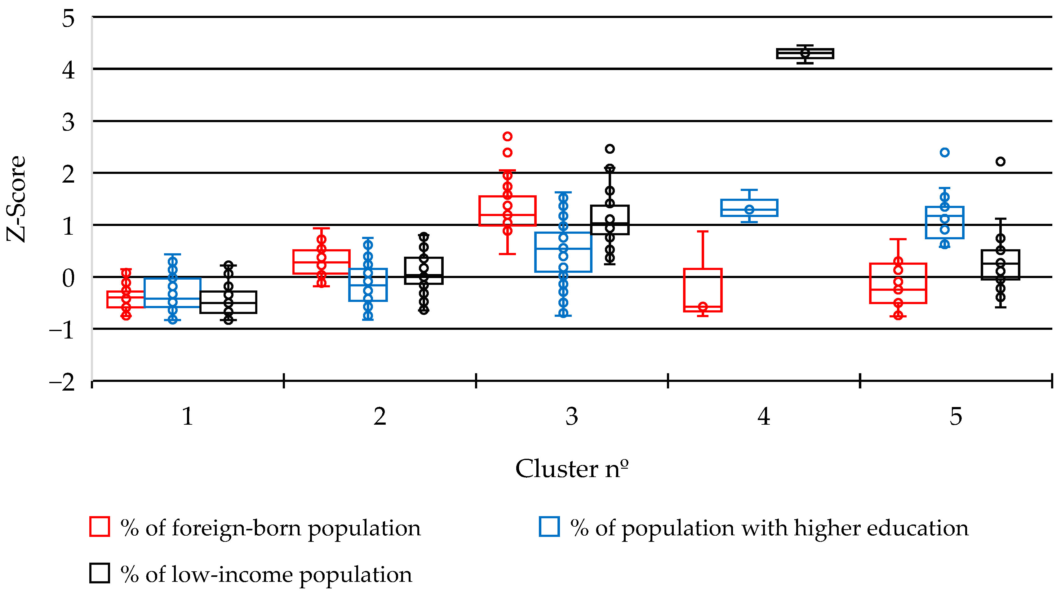
| Trend in Z-Score Values | % of Population with Higher Education | % of Foreign-Born Population | % of Low-Income Population |
|---|---|---|---|
| Increase in the Z-score | Advantaged sector | Disadvantaged sector | Disadvantaged sector |
| Decrease in Z-score values | Disadvantaged sector | Advantaged sector | Advantaged sector |
| Approach | Focus Analysis | What It Measures | Main Limitation | How RII Differs/Improves |
|---|---|---|---|---|
| Spatial autocorrelation indices (e.g., Moran’s I) | Statistical units (e.g., census tracts) | Degree of dissimilarity between neighboring areas | Emphasizes spatial clustering/Ignores internal or limit heterogeneity | RII measures discontinuity along limits, capturing local rupture lines instead of spatial similarity |
| Segregation indices (e.g., Dissimilarity Index) | Population groups within units | Separation of social groups across space | Aggregates populations within fixed zones/Weak spatial context | RII incorporates adjacency and directionality of contrasts between neighboring tracts |
| Composite indicator (e.g., vulnerability indices | Aggregated unit-level data | Multidimensional conditions within areas | Average internal values that can mask transitions | RII uses robust standardized differences between tracts, revealing abrupt or gradual transitions |
| Rupture Intensity Index (RII) | Limits between contiguous areas | Intensity of socio-spatial discontinuity | Requires detailed data and variable selection/It’s highly sensitive to scale factor | Provides a boundary-based, comparable, multidimensional measure of fragmentation |
Disclaimer/Publisher’s Note: The statements, opinions and data contained in all publications are solely those of the individual author(s) and contributor(s) and not of MDPI and/or the editor(s). MDPI and/or the editor(s) disclaim responsibility for any injury to people or property resulting from any ideas, methods, instructions or products referred to in the content. |
© 2025 by the authors. Licensee MDPI, Basel, Switzerland. This article is an open access article distributed under the terms and conditions of the Creative Commons Attribution (CC BY) license (https://creativecommons.org/licenses/by/4.0/).
Share and Cite
Lasala, J.; Bellet, C. Discontinuities, Limits and Barriers: Quantifying the Intensity of Urban Spatial Ruptures. Urban Sci. 2025, 9, 475. https://doi.org/10.3390/urbansci9110475
Lasala J, Bellet C. Discontinuities, Limits and Barriers: Quantifying the Intensity of Urban Spatial Ruptures. Urban Science. 2025; 9(11):475. https://doi.org/10.3390/urbansci9110475
Chicago/Turabian StyleLasala, José, and Carme Bellet. 2025. "Discontinuities, Limits and Barriers: Quantifying the Intensity of Urban Spatial Ruptures" Urban Science 9, no. 11: 475. https://doi.org/10.3390/urbansci9110475
APA StyleLasala, J., & Bellet, C. (2025). Discontinuities, Limits and Barriers: Quantifying the Intensity of Urban Spatial Ruptures. Urban Science, 9(11), 475. https://doi.org/10.3390/urbansci9110475


