Article

Developing a Calculation Workflow for Designing and Monitoring Urban Ecological Corridors: A Case Study

by
Carmine Massarelli
Unit of Environment and Territory Research, Construction Technologies Institute, Italian National Research Council (ITC-CNR), 70124 Bari, Italy
Urban Sci. 2024, 8(4), 169; https://doi.org/10.3390/urbansci8040169
Submission received: 13 September 2024 / Revised: 3 October 2024 / Accepted: 8 October 2024 / Published: 11 October 2024
(This article belongs to the Special Issue Assessing Urban Ecological Environment Protection)

Abstract

:
Urban ecological corridors play a crucial role in biodiversity conservation, connecting fragmented habitats in highly anthropized areas and generating benefits in terms of the sustainability of urban environments. These corridors mitigate the effects of habitat fragmentation, such as reduced genetic diversity and limited species dispersal, while improving the ecological health of urban environments and the well-being of citizens. This study proposes a calculation workflow for the identification of the necessary and most suitable ecological corridors to be planned in the urban-environmental planning phase and identifies some of the existing innovative technologies to evaluate and improve their functionality, enabling the real-time monitoring of habitat conditions and providing valuable information to optimize the design and management of these peri-urban natural areas. Urban ecological corridors also improve human well-being by contributing to cleaner air, better water quality and recreational opportunities to the point that the costs incurred for their construction are much lower than the economic and social benefits for the area.

1. Introduction

Ecological corridors are areas of high naturalistic value due to the presence of habitats that connect larger areas of habitats in fragmented ecosystems [1]. These corridors allow organisms to move between different areas, facilitating the dispersal of species, the search for food, reproduction and migration. In an environmental context where urbanization and infrastructural development can isolate animal and plant populations because they act as ecological barriers even at distances of a few kilometers [2], ecological corridors play a crucial role in maintaining biodiversity and ecosystem health [3].
Habitat fragmentation is one of the main threats to biodiversity [4,5]. Roads, buildings and other urban infrastructures create physical barriers that can limit the movement of species. This isolation can lead to genetic problems, such as reduced genetic diversity, and can compromise the ability of populations to adapt to environmental changes. Ecological corridors help mitigate these effects by providing safe routes through which species can move and interact [6].
In practice, ecological corridors can take different forms: they can be strips of vegetation along rivers [7], connected urban parks [8,9], green roofs [10,11] or other areas within urban landscapes [12]. Designing and managing these corridors requires careful planning to ensure that they are functional and accessible to the species they are intended to support.
The importance of ecological corridors goes beyond simply connecting fragmented habitats. They also contribute to improving human health and quality of life [13]. Connected green spaces provide recreational spaces for people, improve air and water quality and can help reduce the urban heat island effect, which makes cities warmer than surrounding rural areas. Additionally, they promote greater environmental awareness and a sense of connection with nature among urban residents.
Ecological corridors play a key role in mitigating climate change by facilitating the migration and adaptation of species; these corridors can help ecosystems respond to climate change, ensuring that species can find new habitats as climate conditions evolve [12].
A very important aspect is their ability to promote the movement of wildlife through the urban and peri-urban environment: for example, small mammals, birds, reptiles and insects can use ecological corridors to move between different habitat areas. Hedgerows, strips of vegetation along waterways, connected urban parks and even green roofs can act as ecological corridors. These routes provide cover and protection from predators, as well as access to food and nesting sites. Butterflies, for example, can use ecological corridors to find flowers to feed on and suitable places to lay their eggs, thus contributing to their survival and proliferation in urban environments. Other examples are amphibians, which often need to move between aquatic and terrestrial habitats during their life cycle. Ecological corridors that include artificial ponds, canals and wetlands can facilitate these movements, reducing the risk of mortality on busy roads and other hazardous areas. Similarly, larger mammals, such as deer and foxes, may benefit from ecological corridors that help them move between urban parks and peripheral nature reserves.
Urban ecological corridors include forests, parks or linear green areas that help filter the air [14]. Trees and plants absorb carbon dioxide and other air pollutants such as fine dust, reducing pollution and improving air quality in cities [15]. This ecosystem service leads to a decrease in respiratory and cardiovascular diseases among the population, contributing to better public health [16,17].
Ecological corridors, often located along rivers or watersheds, act as natural buffers, reducing water pollution. Plants in ecological corridors filter sediments and excess nutrients (such as fertilizers), preventing them from ending up in waterways and causing eutrophication and pollution [18]. This process improves the quality of drinking water and reduces the risk of flooding, protecting the population and resources [6].
Ecological corridors provide open spaces accessible to the public for recreational activities such as hiking, biking, bird watching and walking [19]. This type of green space improves the quality of urban life, promoting the physical and mental well-being of citizens, as well as encouraging a more active and healthy lifestyle, with a positive impact on the overall health of the population.
Furthermore, their creation leads to overcoming the traditional delimitation of protected areas and implies a more flexible approach to land management, in which the barriers between man and nature are not rigid but permeable. In this sense, various actions can be carried out: the creation of urban ecological corridors with green infrastructures that connect fragmented habitats, agroecology projects that integrate sustainable agricultural techniques within rural areas and sustainable urban design that includes the construction of parks that serve as habitats for wildlife and recreational spaces for the population. These projects, if implemented, contribute to the dynamic management of the landscape, not limited to the passive conservation of protected and urbanized areas but promoting a harmonious integration between man and nature.
Several successful examples from around the world demonstrate how these corridors can transform cities into healthier, more vibrant environments for both wildlife and humans.
A notable example is the UK’s Green Belt Movement [20], which has created a network of parks, nature reserves and greenways that cross the cities, also containing their uncontrolled expansion. This ecological network has not only improved city dwellers’ access to green spaces but also led to a significant increase in biodiversity. For example, populations of birds, butterflies and small mammals have increased significantly due to new habitats and connections between them. Urban foxes, once isolated in small green areas, can now move freely throughout the city, improving the genetic health of their populations.
Another success story is the Cheonggyecheon Stream Restoration project in Seoul, South Korea [21]. This project has transformed an old highway into an ecological stream corridor that runs through the heart of the city. The ecological corridor created along the stream has led to an increase in urban biodiversity, attracting several species of fish, birds and insects that had previously disappeared from the area. The restored creek has also improved air and water quality, providing a natural oasis for residents and tourists.
In Melbourne, Australia, the “Creating Habitat Corridors” project has led to the creation of ecological corridors along major roads and even urban waterways [22]. These corridors have been planted with native plant species that provide food and shelter for local wildlife, as well as pollinators [23]. The return of bees has also had a positive impact on the pollination of local plants, contributing to the resilience of urban ecosystems. As a result, an increase in populations of small mammals, reptiles and birds has been observed.
In New York, the High Line Park is an iconic example of how ecological corridors can be integrated into existing urban infrastructure [24]. This linear park, created on an old, elevated railway line, has become a refuge for many species of plants and animals. The diverse vegetation planted along the trail attracts pollinators such as butterflies and bees, as well as providing habitat for migratory and resident birds. The presence of these organisms has enriched the biodiversity of the area and created a more pleasant environment for human visitors. Green roofs [25] and vertical gardens [26] are also considered ecological corridors which, in addition to acting as a habitat for insects and birds, reduce the urban heat island effect [27]. These structures promote community participation in the care and management of green spaces, increasing environmental awareness and promoting sustainable practices among citizens. The management of these green areas thus becomes a participatory and inclusive process, which integrates the needs of nature with those of the urban population.
In peri-urban environments and agroecosystems, ecological corridors connect natural reserves through some agricultural areas, allowing the dispersion of species and improving ecological connectivity, preserving biodiversity on the one hand and promoting the conversion of agricultural practices in favor of sustainability on the other, promoting the use of cultivation techniques that respect the natural balance. Urban planning that integrates ecological corridors therefore contributes to creating greener, more resilient and sustainable cities, where the harmonious coexistence between man and nature is at the heart of development policies.
Ecological corridors can play a significant role in reducing light pollution in urban areas. These connected green spaces, often designed to protect wildlife and promote biodiversity, can also help mitigate the negative effect of artificial lights on the environment [28]. Light pollution, caused by excessive and poorly directed lighting, has negative impacts on the health of ecosystems and wildlife, altering circadian rhythms and natural animal behaviors [29].
Ecological corridors, designed with careful management of lighting, can create zones of relative darkness, which provide safe havens for nocturnal species. By using techniques such as shaded lighting, the use of narrow-spectrum lights and installing lights that only come on when needed, it is possible to dramatically reduce light pollution in and around ecological corridors. These practices not only protect wildlife but also improve the quality of the night sky for humans.
A practical example is the use of low-intensity and timed lighting in urban parks connected by ecological corridors, which reduces the light impact during the night hours. In cities like Amsterdam, the project “Light on Nature” [30] has implemented smart lighting in ecological corridors, resulting in a significant reduction in light pollution. This approach has allowed us to restore the natural cycles of flora and fauna, improving the health of local ecosystems.
The Puglia Region promotes and develops ecological connectivity spread across the regional territory through projects aimed at the knowledge and sustainable use of the sites of the Regional Ecological Network to strengthen and restore the connection function of ecological corridors, countering the processes of fragmentation of the territory and increasing the ecological functionality and the levels of biodiversity of the regional landscape mosaic [31].
One of these is the ecological corridor of the Cervaro River [31], which is a site of community interest (code SICIT9110032) and contains in its final part the regional protected area Bosco Incoronata, an area rich in many species of significant naturalistic interest [32,33].
The project for the creation of the Regional Ecological Network in Puglia is part of the strategic projects for the redevelopment of the Puglia landscape. Looking at the Master Plan map for the Multipurpose Ecological Network on pages 7 and 8 of the official documentation [34], we can see how the methodology developed and shown previously can reach much greater details than those reported in the official map.
In this study, we create a data processing workflow useful for the design and construction of ecological corridors to connect the nodes of a network of natural areas, and we compare the result with the real perimeter of a protected area rich in species and habitats in which it is necessary, due to the high naturalistic value of the areas but also to the presence of numerous urban centers, to create various ecological corridors of interconnection with other green areas. The critical points and strengths of this current perimeter will be analyzed, thus promoting a useful tool for decision-makers for landscape design functional for the creation of efficient ecological corridors, overcoming the concept of the perimeter of a protected area with the only purpose of preserving the species and habitats present in a geographical space.

2. Materials and Methods

2.1. Study Area

A study on habitat fragmentation and the design of ecological corridors would be particularly useful in different areas of the Puglia Region, considering the environmental specificities and challenges related to biodiversity conservation in this densely populated region.
Brindisi is a coastal city with an important commercial and tourist port affected by the presence of marked coastal urbanization and land use that have reduced natural habitats over time.
The Regional Natural Park “Dune Costiere da Torre Canne a Torre San Leonardo”, located in the Puglia Region in the province of Brindisi, is one of the most suggestive and biodiversity-rich protected areas on the Italian Adriatic coast (Figure 1). Covering an area of approximately 1100 hectares along the coast of the province of Brindisi, this park offers an extraordinary variety of landscapes, ranging from sandy dunes to wetlands, from Mediterranean scrub forests to traditional agricultural areas [35].
The coastal dunes are a characterizing element of the park and, even if they are strongly affected by human phenomena that cause their fragmentation [36], form a unique natural system that hosts numerous rare and endemic plant species, such as the sea lily Pancratium maritimum L. and the prickly juniper Juniperus macrocarpa Sm. The park’s wetlands are crucial for the stopover and nesting of many species of migratory birds, contributing to the conservation of the avian fauna.
The Dune Costiere Regional Natural Park is not only a nature sanctuary but also an area of great historical and cultural interest. Ancient watchtowers, fortified farmhouses and historic sheep tracks bear witness to the rich past of this region, making it a fascinating place for history and archaeology enthusiasts.
Sustainable activities are at the heart of the park’s management, with numerous organic farming and eco-tourism projects aiming to protect the environment and promote local development. Visitors can explore the park through a network of hiking and cycling trails, take part in guided excursions and discover local traditions through events and demonstrations.

2.2. Land Use

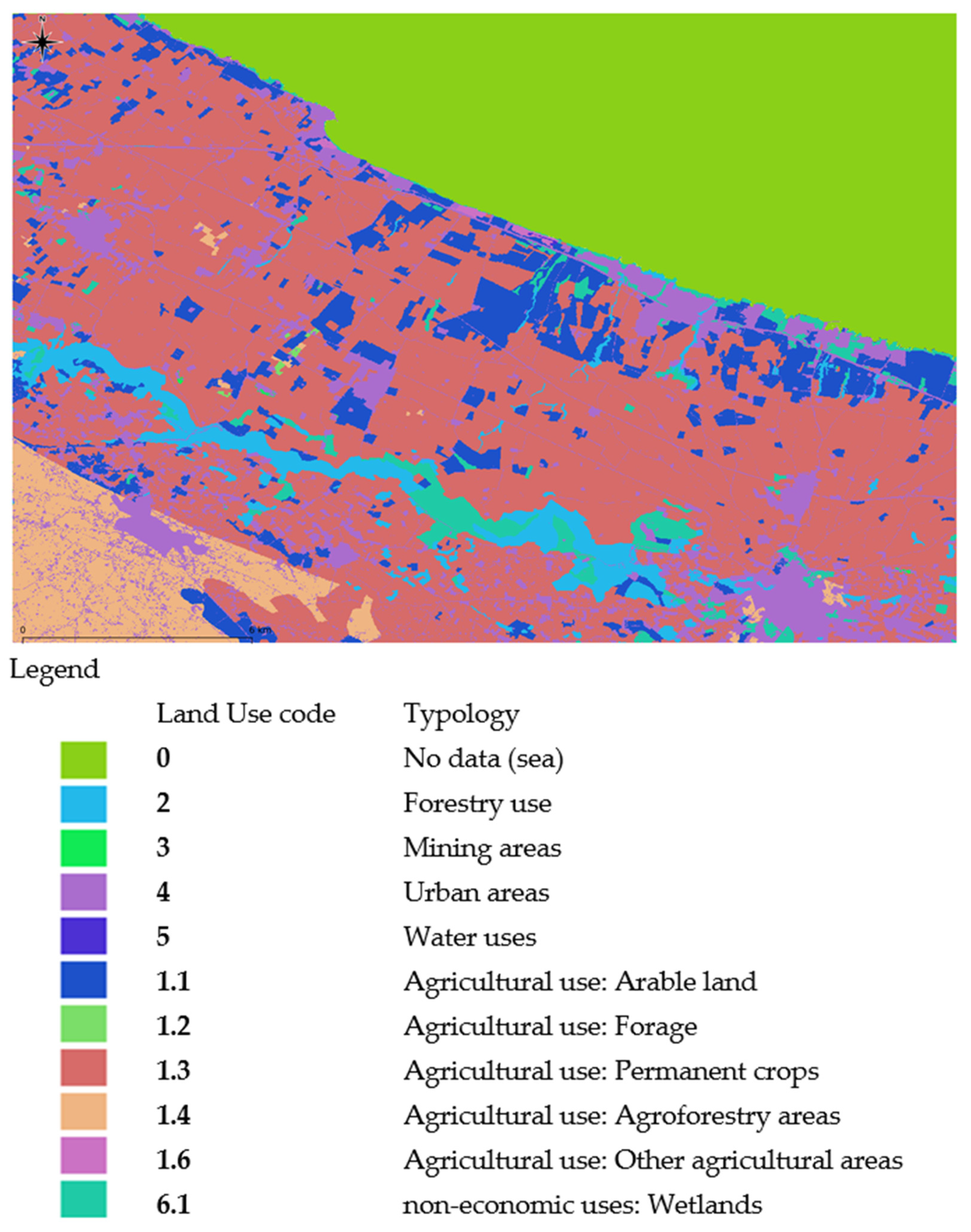
A land use map was obtained by integrating data from the Land Monitoring Service of the Copernicus Programme [37], a European initiative that provides accurate and up-to-date geospatial information. The 2022 land use map was based on Copernicus 2018 data [38] and on the corresponding editions of the Italian Higher Institute for Environmental Protection and Research (ISPRA) National Land Consumption Map [39]. The two types of products, namely land use and land cover, can be compared and integrated for different reference dates, providing a solid basis for monitoring land changes. The analysis of land use maps over time allows us to identify trends and changes in land use, supporting urban planning and sustainable management of natural resources. For example, it is possible to detect the expansion of urbanized areas, the reduction in agricultural or forestry surfaces and the increase in land consumption, providing essential information for the formulation of environmental and territorial policies. In Figure 2, the land use map of the study area is shown.

2.3. The Geo-Database OpenStreetMap

OpenStreetMap (OSM) [40] is a collaborative project that aims to create a free and editable map of the world. Using voluntary contributions, OSM collects geospatial data through GPS devices, aerial imagery and other public sources, making them available to all. This crowdsourcing approach allows maps to be kept up-to-date and detailed, often with better coverage than commercial maps in less developed or rural areas.
Using OpenStreetMap has several advantages such as the free use of data that can be downloaded, modified and used without restrictions. This makes OSM a valuable resource for a wide range of applications, including urban planning, emergency management, tourism and education. The global community of users and contributors ensures that the maps are continuously improved and updated.
A powerful tool for working with OSM data is Overpass API [41], which allows you to run custom queries to download specific data. Using Overpass Query, you can filter data by categories such as buildings, streets, parks, public facilities and more. This flexibility allows users to obtain exactly the data they need for their projects while minimizing the time and resources required for data processing.
The query written to download the data of the extensions of natural and green areas useful for the creation of ecological corridors from OSM is the following:
  • [out:xml] [timeout:25];
  • (
  • node[“landuse”=“forest”]( {{bbox}});
  • node[“natural”=“wood”]( {{bbox}});
  • node[“leisure”=“nature_reserve”]( {{bbox}});
  • way[“landuse”=“forest”]( {{bbox}});
  • way[“natural”=“wood”]( {{bbox}});
  • way[“leisure”=“nature_reserve”]( {{bbox}});
  • relation[“landuse”=“forest”]( {{bbox}});
  • relation[“natural”=“wood”]( {{bbox}});
  • relation[“leisure”=“nature_reserve”]( {{bbox}});
  • );
  • (._;>;);
  • out body;
This choice to consider all urban green areas, including parks, gardens and public spaces, was made to maximize ecological benefits in terms of sustainability and urban resilience. In total, we obtained 470 polygons.

2.4. GIS Software

One of the most powerful software tools in land use planning is the Geographic Information System (GIS). GIS enables urban planners and ecologists to map and analyze urban green spaces, identify the best locations for corridors and monitor the effectiveness of the connections created. Using spatial data, it is possible to model the movement paths of species and predict how these corridors can contribute to the conservation of biodiversity in complex urban contexts. GIS allows you to analyze various factors, such as vegetation density, the presence of artificial barriers and the specific needs of target species, to create corridors that are functional and effective.
There are many pieces of software that can be used to identify ecological corridors; in this study, QuantumGIS (QGIS v.3.22.4-Białowieża) [42], a powerful and versatile open-source software, ideal for advanced landscape analysis, was used. Thanks to its numerous plugins [43], it allows you to evaluate ecological connectivity and habitat fragmentation. QGIS supports the integration of raster and vector data, facilitating multi-scale analysis and management of complex data needed for environmental conservation.
The plugin called Least Cost Path [44] is useful for calculating minimum-cost paths between points on a raster surface representing the motion cost map [45]. It is used to identify optimal routes for ecological corridors, minimizing obstacles and maximizing connectivity.
The algorithm finds the least cost path with a given cost raster and points [46] in a cost grid, using a variant of Dijkstra’s algorithm [47]. The basic steps of the algorithm calculations are reported below in discursive pseudocode:
-
importing numpy libraries [48] for numeric data processing and heapq [49] for priority queue management;
-
least_cost_path function:
--
input: the function takes as input the cost grid, the starting and the arrival points;
--
initialization: a distance matrix is initialized with infinite values and a matrix to keep track of the predecessors to reconstruct the path. The initial distance of the starting point is set to 0;
--
priority queue phase: a priority queue is used to manage the nodes to be explored, while the starting point is added to the queue with cost 0;
--
execution of Dijkstra’s algorithm [50]:
---
extracting the node with the lowest cost from the priority queue;
---
check the extracted node because if it is the arrival point, the algorithm ends;
---
neighbor expansion, i.e., for each neighbor of the current node, the cost to reach it is calculated. If this cost is lower than the cost already recorded for the neighbor, the distance and predecessor are updated and the neighbor is added to the priority queue with the new cost;
--
route reconstruction: once the arrival point is reached, the route is reconstructed by going back through the predecessors from the arrival point to the starting point;
--
output: the function returns the minimum cost path as a list of coordinates and the total cost of the path.
The following tools and algorithms were also used:
-
Raster calculator [51], a tool that allows you to perform advanced mathematical operations on raster data, was used to calculate the cost map;
-
Extract patches algorithm, to isolate different patches based on land use;
-
Centroids algorithm, to identify the geometric center of gravity of the extrapolated patches that assume the function of starting point in the least cost path algorithm.

2.5. Movement Cost Map

Transforming land use into a resistance (or cost) map is a fundamental step in modeling ecological corridors and assessing habitat fragmentation [45,52]. This transformation assigns resistance (or cost) values to different land use categories, which reflects the difficulty or impact an organism faces in crossing those areas.
Cost can be seen not only as a physical restriction but also as a set of factors that influence the ability of organisms to move across the landscape. These factors include not only physical barriers, but also the negative impacts of pollution, habitat loss and human interference, all elements that can “cost” in terms of accessibility and quality of habitat [53].
In these cases, the term also represents the expense in terms of energy and risk that the animals have to face to move around the territory. This analogy can help communicate the idea that conservation requires resources and that ecological planning must consider the costs, this time in terms of economic resources, associated with implementing measures that promote connectivity.
Finally, the use of the term encourages an evaluation of the trade-offs between different management strategies in the design of ecological corridors. Indeed, it is important to consider the costs (both economic and ecological) associated with different intervention options, such as the creation of underground passages or the removal of infrastructures, considering that the functional relationship between the two variables is inverse, that is, the growth of one generates a decrease in the other. The difference with respect to resistance is the dynamic component of the cost, which in this study can be neglected since we are mainly referring to small distances.
Resistance values must be chosen based on the species or group of species of interest and their specific ecological requirements or based on the type of habitat if the analysis is not aimed at a single species. For our case study, we followed this second approach to identify ecological corridors that could unite all the natural areas present in the study area.
Below are reflections on the resistance values assigned for land use categories.
Agricultural areas including arable land (code 1.1), forage crops (code 1.2), permanent crops (code 1.3) and other agricultural areas not classifiable among the previous ones (code 1.6) are assigned a value of 30 as it is true that they can provide habitat for some species but the presence of human activities and especially pesticides can increase resistance. Instead, agricultural areas included in the definition of agroforestry areas (code 1.4) are assigned a value of 10 because agricultural practices are less intensive and can offer moderately favorable habitats only with some disturbance due to forest management. Areas used exclusively for forestry (code 2) are considered even more favorable and are therefore assigned a value of 5.
As regards extractive areas (code 3) and urban areas (code 4), they are generally unfavorable for most species due to the fragmentation and pollution present and also because they represent significant and dangerous barriers to the movement of wildlife (a value of 100 is assigned, which is the maximum in our scale), while mining areas are generally located in green areas and may have secondary vegetation that offers some habitat, and therefore their assigned value is 90.
As regards small areas with water uses (code 5) and wetlands (code 6.1), since these areas are generally favorable for many species as they offer high-quality habitats, the values 2 and 1 are assigned, respectively.
It is specified that the assigned values come from both bibliographical evaluations [53,54,55]. However, these values have been subsequently refined based on our knowledge of the locations and factors that influence the movement of fauna [56]; therefore, they can be considered validated in the field as they are believed to accurately reflect real conditions.
Below is a summary table of the values assigned by type of land use (Table 1) and the resulting cost map (Figure 3).
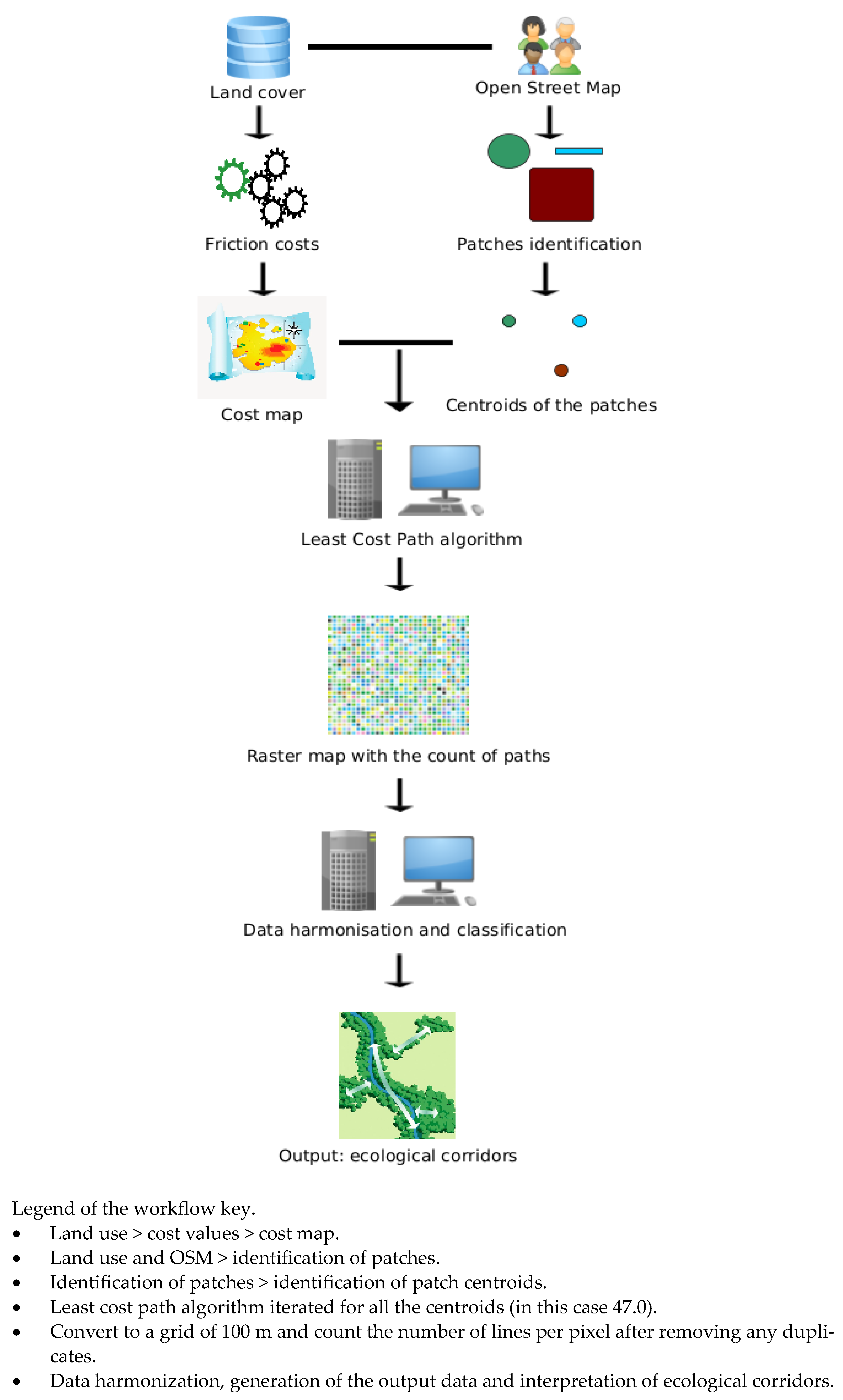
The following figure shows the complete data processing workflow used for ecological corridor analysis (Figure 3).

3. Case Study Results

Below is the map with 470 points representing the centroids of all green areas, i.e., protected areas, areas with high naturalistic value, wooded areas and urban greenery, obtained from the OSM database (Figure 4).
Below is the movement cost map which represents the “cost” that an organism must sustain to move across a territory (Figure 5). Each pixel in the map area is assigned a value that reflects the difficulty of movement, based on previously reported factors. The higher the value, the more difficult the transition is.
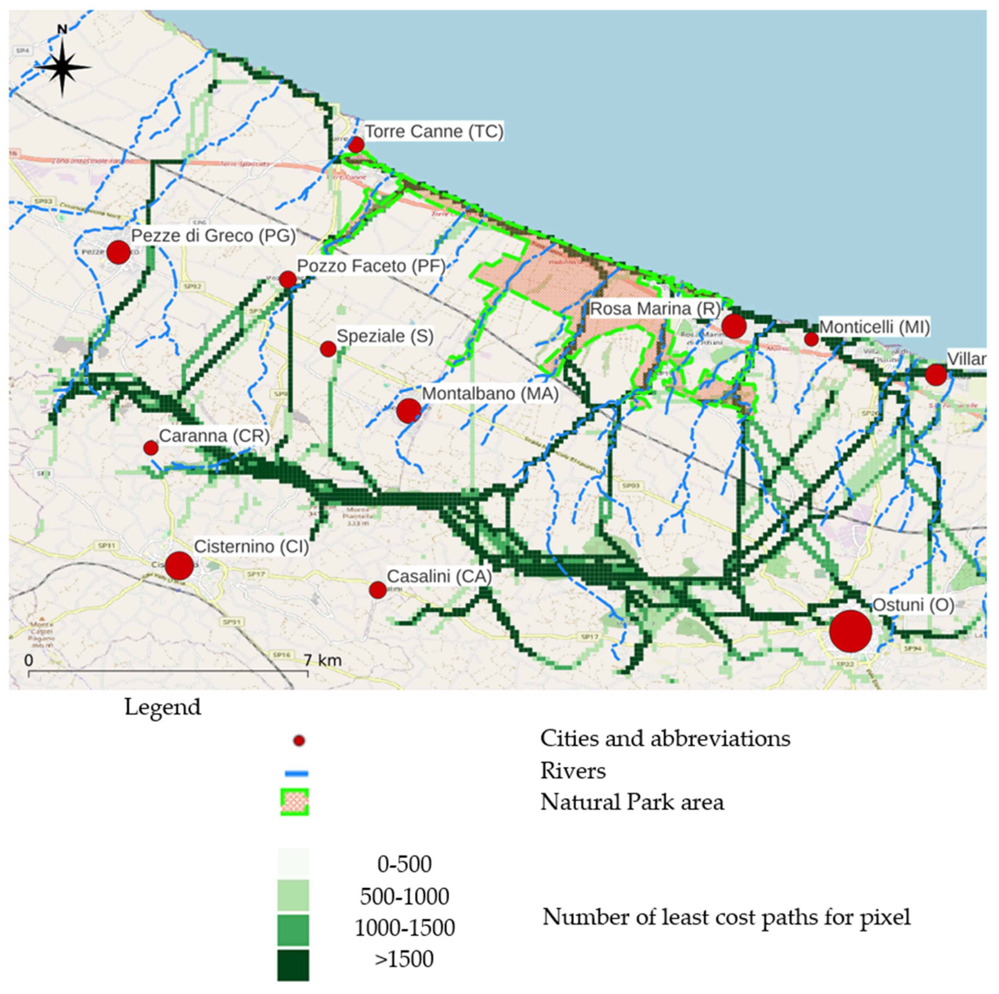
Once the map in Figure 5 is obtained, it is possible to launch the least cost path algorithm. The following map represents the areas needed and most suitable to act as ecological corridors, based on the number of times the least cost path connections cross each pixel of the study area divided into a 100 m grid. The most frequently crossed pixels indicate the optimal paths for wildlife, highlighting areas with the least resistance to movement. Furthermore, the map shows the position of the residential areas, represented by dots of variable size depending on the population density: the larger dots indicate more populous urban areas. The map also shows the perimeter of the protected area “Dune Costiere Regional Natural Park” to provide a useful visual framework for territorial planning and the conservation of biodiversity and the paths of the rivers, typically used by fauna as ecological corridors (Figure 6).

4. Discussion

Looking carefully at the results obtained (Figure 5), it is evident how the connection between green natural areas and coastal zones is, in some cases, ensured by the presence of ecological corridors along the rivers (which are also well protected as they fall within a protected area); it is possible to notice a perfect overlap between the river and ecological corridor of Pozzo Faceto (PF) and between Casilini (CA) and Rosa Marina (R). However, this best practice is not always respected, especially in the southwest areas where the protected area is no longer present and where the results indicate the need to create many ecological corridors.
The protected area designation refers to the legal or administrative framework established to conserve biodiversity and natural resources within the area. These areas are often designated under national or regional laws, such as nature reserves, national parks or Special Areas of Conservation (SACs) under international frameworks like the European Union’s Natura 2000 network.
This certainly creates a certain difficulty for species to propagate freely in that portion of territory.
In some cases, the identified ecological corridors are interrupted due to the abrupt transition from natural areas to areas with different uses (mainly intensive agriculture).
Some urban agglomerations, for example, Monticelli (MI), Villanova (V) and partially Rosa Marina (R), in the east of Figure 6, seem to allow the spread of species by adopting compatible urban planning, with others allowing the spread of species less, like Ostuni (O), where species can move freely just outside the urban center which appears densely populated (it looks like a green belt like the UK model). This also happens because the agglomerations of Monticelli (MI), Villanova (V) and Rosa Marina (R) are not very compact and populous and are at the same time rich in green areas, while in the case of large agglomerations, we notice how the ecological corridors deviate to avoid them.
The most serious case seems to be in Pezze di Greco (PG), in the north-west of Figure 6, where there is a marked deviation of the ecological corridor in a small agglomeration despite the presence of a small river nearby; this is certainly due to the presence of intensive agriculture.
What could cities do to promote the development of ecological corridors in urban and peri-urban areas?
Vancouver in Canada and Portland, Oregon, in the USA are known for their commitment to environmental conservation and the creation of ecological corridors; cities have implemented numerous ecological corridors that connect parks, nature reserves and green areas, promoting habitat connectivity for wildlife, achieving increased urban biodiversity and better management of public greenery, and consequently improving the quality of urban life.
Cities like Los Angeles and Santa Monica in California, USA, as well as various cities in India which are very large and have dense urbanization and a complex road network, have never developed an urban planning policy towards the creation of ecological corridors; this has led to the fragmentation of natural habitats with the isolation of parks and green areas causing a decrease in biodiversity, greater conflicts between wildlife and humans and a less healthy quality of the urban environment overall [59,60,61].
Although our case study focuses on a predominantly rural area in southern Italy, the principles behind ecological corridors are applicable in both rural and urban contexts. Fragmented habitats and the need to connect these areas to facilitate wildlife movement are common issues in both scenarios. Solutions adopted in large metropolises were cited to illustrate innovative approaches that could also be adapted to less densely populated contexts.
However, we recognize that differences in scale and population density require specific considerations. In a rural area, such as our case study, ecological corridors may have to cross agricultural lands or forested areas, while in cities, these corridors need to be integrated into densely populated urban spaces. Despite these differences, the guiding principle is the same, and concepts that find application in urban settings can be reinterpreted to respond to specific local needs. For example, in urban contexts, ecological corridors often face limitations related to space and the presence of infrastructure, while in rural areas, there is greater flexibility, but other challenges such as the presence of intensive agriculture may be encountered.
It follows that despite the basic similarities in ecological challenges, solutions must be tailored to the specific context, as well as to the types of species or habitats to be preserved. This study in the Puglia Region is part of a context in which the issue of protection of natural areas is particularly heart-felt due to the coexistence of agricultural communities and the presence of protected natural areas. Ecological corridors must therefore be integrated into sustainable rural development strategies.
While the construction of ecological corridors in large cities is often aimed at redeveloping degraded areas or creating urban green spaces, in rural Italian contexts, these corridors can serve to connect existing nature reserves, increasing the effectiveness of conservation measures. This difference in the function and protection of corridors represents a fundamental adaptation of urban planning principles to rural realities.
Below is a comparison with other case studies at the Italian and European level. In Italy, ecological corridors are protected within a broader framework of environmental and landscape conservation policies, including national laws such as Law 394/1991 on protected areas, regional regulations, and European directives such as the Habitats Directive (92/43/EEC) and the Birds Directive (2009/147/EC). These legal frameworks aim to preserve biodiversity and ensure ecological connectivity between protected areas. Despite these regulatory protections, practical implementation often faces challenges due to fragmentation of habitats and conflicting land use priorities.
An Italian project on the subject of ecological corridors is the project LIFE EC-SQUARE [62], which focuses on the conservation of the European red squirrel (Sciurus vulgaris) through the improvement of connectivity between fragmented habitats in the regions of northern Italy. This objective is achieved by adopting forest management techniques that promote a mixed composition of conifers and broadleaf trees capable of ensuring a diverse food source available throughout the year. Furthermore, maintaining a multi-layered forest structure, with trees of varying ages (young, mature and old), increases the availability of food and shelter, promoting biodiversity and ecosystem resilience.
At the European level, the project funded by the European Union ECONNECT [63] involves several Alpine nations (Italy, Switzerland, France, Germany, Austria) and has the main objective of strengthening ecological connectivity between protected areas in the Alps, improving the mobility of species in a highly anthropized environment. The aim is pursued through an integrated and multidisciplinary approach aimed at encouraging the creation of an ecological continuum in the Alps. The main activities are related to the collection of detailed information to harmonize the geographical data concerning all the countries involved and to consider any physical or legal obstacle to the creation of ecological corridors between areas of high biodiversity value. The aim is to test new solutions for the creation of ecological corridors in pilot regions with a high biodiversity rate. This multidisciplinary approach represents the real strength of this project. The ability to constantly integrate new data is extremely beneficial; however, it is important to take into account that increasing data volumes require more powerful computers to handle them effectively.
The data system employed in our study significantly enhances the protection of ecological corridors by providing high-resolution spatial analysis and real-time monitoring of environmental conditions. By integrating detailed spatial data (e.g., land use, habitat types and species distribution) with advanced modeling techniques such as least cost path analysis, the system allows for more precise identification of critical ecological corridors and areas at risk.
Collecting data at 100 m resolution offers numerous advantages in identifying ecological corridors, helping to improve the accuracy and precision of analyses. A resolution of 100 m allows you to analyze changes in the landscape in more detail than lower resolutions: it is possible to identify different microhabitats and habitats for different animal species, allowing us to consider the specificity of the corridors for the most important species to be protected.
Additionally, with more granular data, it is easier to detect physical obstacles and barriers (such as small paths and roads, buildings or other infrastructures) allowing for more effective planning of ecological corridors through connectivity models. With high-resolution data, it is possible to calculate the potential for fauna movement and species dispersal more accurately by identifying the best routes, as well as evaluating the distribution of species and their interactions with the environment through detailed mapping. This is essential for identifying areas of high biodiversity that act as important nodes within an ecological corridor network.
Finally, with higher data resolution, it is possible to capture more rapid environmental changes and their influences on ecological corridors, such as hydrological variations or changes in land use, species distribution and climate change. Data integration is certainly the basis of future research prospects through the use of innovative technologies.

Future Research Perspectives

Let us see how the use of innovative technologies is revolutionizing the design, implementation and monitoring of urban ecological corridors, offering powerful tools to improve ecological connectivity and protection of urban ecosystems and, at the same time, mitigating negative impacts on the environment.
Some examples of the technologies used are as follows:
  • Drones can be used to survey large areas quickly and non-invasively. With high-resolution cameras and thermal sensors, drones can detect the presence of animals and monitor their behavior, especially in areas that are difficult to access. For example, in Canada, drones have been used to map areas along the Bow River [64,65], identifying sections that needed interventions to improve habitat connectivity for aquatic and terrestrial species. Thanks to the high-resolution images obtained from drones, it is possible to plan and implement targeted interventions, such as the creation of wildlife passages and the planting of native vegetation. Drones can fly over large areas at regular intervals, collecting up-to-date data on habitat conditions and wildlife presence. For example, in Australia, drones are used to monitor ecological corridors along the coasts, collecting data on seabird populations and coastal vegetation [66]. This monitoring allows for the early detection of threats, such as the invasion of non-native species or changes in land use, allowing for rapid and targeted interventions.
  • Artificial intelligence (AI) is particularly useful for analyzing large amounts of environmental data and modeling species movements, helping to identify the best routes through ecological corridors. AI algorithms can be used to analyze topographic, climate and biological data to design corridors that maximize connectivity and species survival. AI enables the simulation of various scenarios and assessment of the impact of different corridor configurations, optimizing design decisions. AI can analyze data collected from drones and other sources, identifying patterns and trends that may not be apparent to the naked eye [67]. A successful example is the work carried out by the Kenya Wildlife Service which uses drones and AI to map and monitor ecological corridors for elephants [68]. Drones provide up-to-date data on vegetation and elephant movements, while AI analyzes these data to predict the animals’ future routes and identify potential threats. In an urban context, drones could be used to map nests of species with high conservation value, threatened species and very wary species. This approach improves connectivity between national parks and reserves, reducing human–wildlife conflicts and promoting long-term conservation.
  • Environmental DNA (eDNA) analysis: This technique involves taking samples of water, soil or air to detect traces of DNA released by animals. eDNA allows for monitoring of the presence of species without the need for direct sightings, offering an effective method to evaluate the fauna that uses ecological corridors.
  • Camera traps: These devices are equipped with motion sensors, usually of the passive infrared type, and cameras that take photos or record videos when they detect the presence of animals. Camera traps are particularly useful for monitoring elusive or nocturnal species and can be installed along ecological corridors to record and census the passage of animals and to plan new ones based on their continuous presence in certain areas [69]. The installation of photo traps in areas preferred by animals allows us to identify the areas to be maintained (in which connectivity is not compromised), strengthened (in which it is only partially compromised) and compromised (in which connectivity is strongly compromised). In the two previous cases, the pressure factors must always be analyzed.
  • GPS and telemetry: GPS collars can be applied to individuals of various species to track their movements. This technology provides precise data on the paths used by animals, allowing us to evaluate the effectiveness of ecological corridors and identify any barriers to movement. The recorded data can be easily managed with GIS software through which it is possible to obtain all the routes traveled and the movements [70].
  • Acoustic sensors: These devices record the sounds produced by animals, such as calls and vocalizations, allowing the identification of many species. Acoustic sensors are particularly used to monitor the biodiversity of birds and amphibians in urban and peri-urban environments.
The combined use of these technologies allows the collection of complete and accurate data on the presence and behavior of animals in urban and peri-urban environments, facilitating the evaluation of the functionality of ecological corridors. These data are essential for sustainable urban planning and management, ensuring the connection between fragmented habitats and biodiversity conservation, as well as offering insights for better design, implementation and monitoring of ecological corridors, offering extraordinary opportunities to improve environmental management in urban and peri-urban environments.
This improved accuracy supports more informed decision-making by policymakers and planners, enabling targeted interventions that strengthen ecological connectivity. Additionally, the system facilitates the continuous updating of data, allowing for adaptive management of the corridors in response to changing environmental conditions or human activities. In this way, it contributes to more effective protection and management of ecological corridors, promoting long-term biodiversity conservation in Italy.
All the following technologies can be used to save animals’ lives: acoustic sensors, infrared cameras, facial recognition systems, and software that transmits data, in real time, to park rangers who can better combat the illegal hunting of animals.
Finally, the transformation of the landscape to make it more compliant with ecological principles induces another radical transformation: the integration of ecological transport systems to reduce environmental impact and improve sustainability towards an ever-greater ecological transition. The implementation of compensation works in environmental design and the integration of green technologies in transport can significantly reduce greenhouse gas emissions, contributing to the fight against climate change. The ever-increasing integration of intelligent transport systems and the active participation of communities is also essential for long-term success [71].

5. Conclusions

Ecological corridors represent a crucial element for the conservation of biodiversity, especially in urban and peri-urban contexts where habitat fragmentation is particularly high. The possibility of adopting an approach based on high-resolution data, together with the implementation of advanced technologies such as drones, sensors and artificial intelligence, constitutes a fundamental resource for improving the planning, management and real-time monitoring of these corridors.
This granularity of information allows for more precise identification of critical points, such as areas most vulnerable to fragmentation or degradation, facilitating targeted and timely interventions. For example, drones can be used to monitor vegetation growth or land use by wildlife in real time, reducing monitoring costs and increasing efficiency.
In addition, the combination of artificial intelligence in big data processing offers new opportunities to rapidly analyze large volumes of data and predict the evolution of urban ecosystems in response to management interventions in detail.
Another key aspect is the scalability of this method. Although advanced technologies are currently applied mainly in small urban or peri-urban areas, this method can be expanded to larger territories. The integration of digital infrastructures such as sensor networks with regional coverage, or the adoption of shared management platforms between different local authorities, would make ecological management possible at a regional or national scale. This scalable approach can help regenerate degraded areas, such as brownfields, while promoting the creation of urban microhabitats, including community gardens and urban allotments, which serve as refuges for wildlife.
However, one of the main limitations concerns the availability of real-time environmental data and the presence of adequate infrastructures for continuous monitoring. While emerging technologies offer enormous opportunities, their large-scale implementation requires significant resources and adaptations depending on local ecological and socio-economic characteristics. Variability between cities, for example, in terms of population density, existing infrastructure and habitat diversity, may require tailored approaches.
Finally, engaging local communities through educational programs and volunteer projects will be essential to the long-term success of any such strategies. Active citizen participation can not only improve the acceptance of proposed solutions but also help monitor and maintain these ecological corridors over time, ensuring their sustainability.

Funding

This research received no external funding.

Data Availability Statement

Data is contained within the article.

Conflicts of Interest

The author declares no conflicts of interest.

References

  1. Popescu, O.C.; Tache, A.V.; Petrișor, A.I. Methodology for Identifying Ecological Corridors: A Spatial Planning Perspective. Land 2022, 11, 1013. [Google Scholar] [CrossRef]
  2. Shi, H.; Shi, T.; Yang, Z.; Wang, Z.; Han, F.; Wang, C. Effect of Roads on Ecological Corridors Used for Wildlife Movement in a Natural Heritage Site. Sustainability 2018, 10, 2725. [Google Scholar] [CrossRef]
  3. Wen, C.; Qiu, Y.; Wang, L. Identifying Key Locations of the Ecological-Barrier System to Support Conservation Planning: A Study of the Sanjiangyuan National Park. Forests 2024, 15, 1202. [Google Scholar] [CrossRef]
  4. Renó, V.; Novo, E.; Escada, M. Forest Fragmentation in the Lower Amazon Floodplain: Implications for Biodiversity and Ecosystem Service Provision to Riverine Populations. Remote Sens. 2016, 8, 886. [Google Scholar] [CrossRef]
  5. Sobhani, P.; Esmaeilzadeh, H.; Barghjelveh, S.; Sadeghi, S.M.M.; Marcu, M.V. Habitat Integrity in Protected Areas Threatened by Lulc Changes and Fragmentation: A Case Study in Tehran Province, Iran. Land 2022, 11, 6. [Google Scholar] [CrossRef]
  6. Gregory, A.; Spence, E.; Beier, P.; Garding, E. Toward Best Management Practices for Ecological Corridors. Land 2021, 10, 140. [Google Scholar] [CrossRef]
  7. Han, Q.; Wang, X.; Li, Y.; Zhang, Z. River Ecological Corridor: A Conceptual Framework and Review of the Spatial Management Scope. Int. J. Environ. Res. Public Health 2022, 19, 7752. [Google Scholar] [CrossRef]
  8. Wang, H.; Pei, Z. Urban Green Corridors Analysis for a Rapid Urbanization City Exemplified in Gaoyou City, Jiangsu. Forests 2020, 11, 1374. [Google Scholar] [CrossRef]
  9. Yang, Y.; Zhou, Y.; Feng, Z.; Wu, K.; Petri¸sor, P.; Yang, Y.; Zhou, Y.; Feng, Z.; Wu, K. Making the Case for Parks: Construction of an Ecological Network of Urban Parks Based on Birds. Land 2022, 11, 1144. [Google Scholar] [CrossRef]
  10. Pardela, Ł.; Kowalczyk, T.; Bogacz, A.; Kasowska, D. Sustainable Green Roof Ecosystems: 100 Years of Functioning on Fortifications—A Case Study. Sustainability 2020, 12, 4721. [Google Scholar] [CrossRef]
  11. Mayrand, F.; Clergeau, P. Green Roofs and Green Walls for Biodiversity Conservation: A Contribution to Urban Connectivity? Sustainability 2018, 10, 985. [Google Scholar] [CrossRef]
  12. Cardone, B.; D’Ambrosio, V.; Di Martino, F.; Miraglia, V.; Rigillo, M. Analysis of the Ecological Efficiency Increase of Urban Green Areas in Densely Populated Cities. Land 2023, 12, 523. [Google Scholar] [CrossRef]
  13. Lin, Q.; Song, Y.; Zhang, Y.; Hao, J.L.; Wu, Z. Strategies for Restoring and Managing Ecological Corridors of Freshwater Ecosystem. Int. J. Environ. Res. Public Health 2022, 19, 15921. [Google Scholar] [CrossRef] [PubMed]
  14. Graviola, G.R.; Ribeiro, M.C.; Pena, J.C. Reconciling Humans and Birds When Designing Ecological Corridors and Parks within Urban Landscapes. Ambio 2022, 51, 253–268. [Google Scholar] [CrossRef]
  15. Chang, S.C.; Tu, C.J.; Chen, H.Y. Ecological Corridor in the Urban Area: Case Study in Kaohsiung City, Taiwan. Pract. Period. Hazard. Toxic Radioact. Waste Manag. 2009, 14, 76–88. [Google Scholar] [CrossRef]
  16. Chen, H.S.; Lin, Y.C.; Chiueh, P. Te Nexus of Ecosystem Service-Human Health-Natural Resources: The Nature-Based Solutions for Urban PM2.5 Pollution. Sustain. Cities Soc. 2023, 91, 104441. [Google Scholar] [CrossRef]
  17. Manes, F.; Marando, F.; Capotorti, G.; Blasi, C.; Salvatori, E.; Fusaro, L.; Ciancarella, L.; Mircea, M.; Marchetti, M.; Chirici, G.; et al. Regulating Ecosystem Services of Forests in Ten Italian Metropolitan Cities: Air Quality Improvement by PM10 and O3 Removal. Ecol. Indic. 2016, 67, 425–440. [Google Scholar] [CrossRef]
  18. Massarelli, C.; Losacco, D.; Tumolo, M.; Campanale, C.; Uricchio, V.F. Protection of Water Resources from Agriculture Pollution: An Integrated Methodological Approach for the Nitrates Directive 91/676/EEC Implementation. Int. J. Environ. Res. Public Health 2021, 18, 13323. [Google Scholar] [CrossRef] [PubMed]
  19. Istomina, E.A.; Luzhkova, N.M.; Khidekel’, V.V. Birdwatching Tourism Infrastructure Planning in the Ria Formosa Natural Park (Portugal). Geogr. Nat. Resour. 2016, 37, 371–378. [Google Scholar] [CrossRef]
  20. Romero-Calcerrada, R.; Cabello, J.; Pacheco-Romero, M.; Monchet, K.T.; Mirici, M.E. The Ecosystem Services and Green Infrastructure: A Systematic Review and the Gap of Economic Valuation. Sustainability 2022, 14, 517. [Google Scholar] [CrossRef]
  21. Cheonggyecheon Stream Restoration Project|Urban Nature Atlas. Available online: https://una.city/nbs/seoul/cheonggyecheon-stream-restoration-project (accessed on 9 September 2024).
  22. Growth Corridor Plans—VPA. Available online: https://vpa.vic.gov.au/metropolitan/growth-corridor-plans/ (accessed on 9 September 2024).
  23. The Melbourne Pollinator Corridor—Increasing Indigenous Biodiversity in Our City|District 9800. Available online: https://www.rotarydistrict9800.org.au/stories/the-melbourne-pollinator-corridor-increasing-indigenous-biodiversity-in-our-city (accessed on 9 September 2024).
  24. Reichl, A.J. The High Line and the Ideal of Democratic Public Space. Urban Geogr. 2016, 37, 904–925. [Google Scholar] [CrossRef]
  25. Braaker, S.; Ghazoul, J.; Obrist, M.K.; Moretti, M. Habitat Connectivity Shapes Urban Arthropod Communities: The Key Role of Green Roofs. Ecology 2014, 95, 1010–1021. [Google Scholar] [CrossRef]
  26. Başdoğan, G.; Çığ, A. Ecological-Social-Economical Impacts of Vertical Gardens in the Sustainable City Model. Yuz. Yıl Univ. J. Agric. Sci. 2016, 26, 430–438. [Google Scholar]
  27. Shao, H.; Kim, G. A Comprehensive Review of Different Types of Green Infrastructure to Mitigate Urban Heat Islands: Progress, Functions, and Benefits. Land 2022, 11, 1792. [Google Scholar] [CrossRef]
  28. Jägerbrand, A.K.; Bouroussis, C.A. Ecological Impact of Artificial Light at Night: Effective Strategies and Measures to Deal with Protected Species and Habitats. Sustainability 2021, 13, 5991. [Google Scholar] [CrossRef]
  29. Grubisic, M.; Haim, A.; Bhusal, P.; Dominoni, D.M.; Gabriel, K.M.A.; Jechow, A.; Kupprat, F.; Lerner, A.; Marchant, P.; Riley, W.; et al. Light Pollution, Circadian Photoreception, and Melatonin in Vertebrates. Sustainability 2019, 11, 6400. [Google Scholar] [CrossRef]
  30. Light on Nature. Available online: https://lichtopnatuur.org/en (accessed on 9 September 2024).
  31. La Rete Ecologica Della Puglia—Life Sic2sic—In Bici Attraverso La Rete Natura 2000 Italiana. Available online: https://lifesic2sic.eu/la-rete-ecologica-della-puglia-15/ (accessed on 9 September 2024).
  32. Massarelli, C.; Campanale, C. Climatic, Bioclimatic, and Pedological Influences on the Vegetation Classification of “Bosco Dell’Incoronata” in Southern Italy. Rend. Lincei 2023, 34, 537–552. [Google Scholar] [CrossRef]
  33. Parco Naturale Regionale Bosco Incoronata—Wikipedia. Available online: https://it.wikipedia.org/wiki/Parco_naturale_regionale_Bosco_Incoronata (accessed on 10 September 2024).
  34. Five Territorial Projects for the Regional Landscape. Available online: http://paesaggio.regione.puglia.it/PPTR_2015/4_Lo%20scenario%20strategico/4.2_cinque%20progetti%20territoriali%20per%20il%20paesaggio%20regionale.pdf (accessed on 10 September 2024).
  35. Web Page of Parco Naturale Regionale da Torre Canne e Torre S. Leonardo. Available online: https://www.parcodunecostiere.org/newsite/ita/index.php (accessed on 9 September 2024).
  36. Binetti, M.S.; Campanale, C.; Uricchio, V.F.; Massarelli, C. In-Depth Monitoring of Anthropic Activities in the Puglia Region: What Is the Acceptable Compromise between Economic Activities and Environmental Protection? Sustainability 2023, 15, 8875. [Google Scholar] [CrossRef]
  37. Land|Copernicus Project. Available online: https://www.copernicus.eu/en/copernicus-services/land (accessed on 6 September 2024).
  38. Copernicus Land Monitoring Service. Available online: https://land.copernicus.eu/ (accessed on 28 November 2022).
  39. Use of Soil—English. Available online: https://www.isprambiente.gov.it/en/databases/data-base-collection/soil-and-territory/use-of-soil?set_language=en (accessed on 9 September 2024).
  40. OpenStreetMap. Available online: https://www.openstreetmap.org/about (accessed on 30 January 2024).
  41. Overpass API—OpenStreetMap Wiki. Available online: https://wiki.openstreetmap.org/wiki/Overpass_API (accessed on 30 January 2024).
  42. Spatial without Compromise·QGIS Web Site. Available online: https://qgis.org/ (accessed on 6 September 2024).
  43. QGIS Python Plugins Repository. Available online: https://plugins.qgis.org/plugins/ (accessed on 9 September 2024).
  44. Least-Cost Path—QGIS Python Plugins Repository. Available online: https://plugins.qgis.org/plugins/leastcostpath/ (accessed on 6 September 2024).
  45. Lee, J.A.; Chon, J.; Ahn, C. Planning Landscape Corridors in Ecological Infrastructure Using Least-Cost Path Methods Based on the Value of Ecosystem Services. Sustainability 2014, 6, 7564–7585. [Google Scholar] [CrossRef]
  46. LeastCostPath/Least_cost_path_algorithm.Py at Master ·Gooong/LeastCostPath. Available online: https://github.com/Gooong/LeastCostPath/blob/master/least_cost_path_algorithm.py (accessed on 9 September 2024).
  47. Dijkstra, E.W. A Note on Two Problems in Connexion with Graphs. Numer. Math. 1959, 1, 269–271. [Google Scholar] [CrossRef]
  48. Numpy.Array—NumPy v1.21 Manual. Available online: https://numpy.org/doc/stable/reference/generated/numpy.array.html (accessed on 28 November 2021).
  49. Library Heapq—Heap Queue Algorithm—Python 3.12.5 Documentation. Available online: https://docs.python.org/3/library/heapq.html (accessed on 9 September 2024).
  50. LeastCostPath/Dijkstra_algorithm.Py at Master ·Gooong/LeastCostPath. Available online: https://github.com/Gooong/LeastCostPath/blob/master/dijkstra_algorithm.py (accessed on 9 September 2024).
  51. Raster Analysis—QGIS Documentation. Available online: https://docs.qgis.org/3.34/en/docs/user_manual/working_with_raster/raster_analysis.html#id3 (accessed on 9 September 2024).
  52. Sawyer, S.C.; Epps, C.W.; Brashares, J.S. Placing Linkages among Fragmented Habitats: Do Least-Cost Models Reflect How Animals Use Landscapes? J. Appl. Ecol. 2011, 48, 668–678. [Google Scholar] [CrossRef]
  53. Calculating Accumulated Cost Surface and Least-Cost Pathway: Tutorial. Available online: https://www.csr.ufmg.br/dinamica/dokuwiki/doku.php?id=tutorial:calculating_accumulated_cost_surface_and_least-cost_pathway (accessed on 9 September 2024).
  54. Mörtberg, U.; Zetterberg, A.; Gontier, M. Landskapsekologisk Analys i Stockholms Stad Metodutveckling Med Groddjur Som Exempel. 2006. Available online: https://miljobarometern.stockholm.se/content/docs/tema/natur/Habitatverktyg_groddjur_2008.pdf (accessed on 1 March 2018).
  55. Furberg, D.; Ban, Y.; Mörtberg, U. Monitoring Urban Green Infrastructure Changes and Impact on Habitat Connectivity Using High-Resolution Satellite Data. Remote Sens. 2020, 12, 3072. [Google Scholar] [CrossRef]
  56. Massarelli, C.; Campanale, C.; Uricchio, V.F. Monitoring of Coastal Dunes and Lagoons: Important Ecosystems to Safeguard. Environments 2023, 10, 211. [Google Scholar] [CrossRef]
  57. Friction and Least-Cost Paths—EEG 260—GIS & Remote Sensing. Available online: https://geol260.academic.wlu.edu/course-notes/location-related-calculations/friction-and-least-cost-paths/ (accessed on 9 September 2024).
  58. Riparian Buffers as Wildlife Corridors|Continuous Riparian|Flickr. Available online: https://www.flickr.com/photos/placeuvm/483784417 (accessed on 12 September 2024).
  59. Habitat Loss and Fragmentation—Santa Monica Mountains National Recreation Area (U.S. National Park Service). Available online: https://www.nps.gov/samo/learn/nature/habitatloss.htm (accessed on 9 September 2024).
  60. Habitat Loss in Los Angeles and What to Do to Help—Ecosystemic Magazine. Available online: https://ecosystemicmag.org/erosion-and-habitat-loss-esme-hyatt/ (accessed on 9 September 2024).
  61. Habitat Fragmentation and Its Impact on India’s Biodiversity Hotspots. Available online: https://india.mongabay.com/2024/07/explainer-how-does-habitat-fragmentation-impact-indias-biodiversity-hotspots/ (accessed on 9 September 2024).
  62. LIFE 3.0—LIFE09 NAT/IT/000095. Available online: https://webgate.ec.europa.eu/life/publicWebsite/project/LIFE09-NAT-IT-000095/eradication-and-control-of-grey-squirrel-actions-for-preservation-of-biodiversity-in-forest-ecosystems (accessed on 3 October 2024).
  63. Econnect—Restoring the Web of Life|Homepage. Available online: http://www.econnectproject.eu/cms/?q=homepage/it (accessed on 3 October 2024).
  64. Bow River Reservoir Options|Alberta.Ca. Available online: https://www.alberta.ca/bow-river-reservoir-options (accessed on 10 September 2024).
  65. Bow River, Alberta Drone Video—YouTube. Available online: https://www.youtube.com/watch?v=spYLzB2RQq8 (accessed on 10 September 2024).
  66. Wilson, J.P.; Amano, T.; Fuller, R.A. Drone-Induced Flight Initiation Distances for Shorebirds in Mixed-Species Flocks. J. Appl. Ecol. 2023, 60, 1816–1827. [Google Scholar] [CrossRef]
  67. Yin, X.; Li, J.; Kadry, S.N.; Sanz-Prieto, I. Artificial Intelligence Assisted Intelligent Planning Framework for Environmental Restoration of Terrestrial Ecosystems. Environ. Impact Assess. Rev. 2021, 86, 106493. [Google Scholar] [CrossRef]
  68. Report on Wildlife Corridors and Dispersal Areas|Kenya Wildlife Service. Available online: https://kwcakenya.com/wp-content/uploads/2018/01/Report-on-Wildlife-Corridors-and-Dispersal-Areas-Final-July-2017.pdf (accessed on 1 March 2018).
  69. O’Connell, A.F.; Nichols, J.D.; Karanth, K.U. (Eds.) Camera Traps in Animal Ecology: Methods and Analyses; Springer: Tokyo, Japan, 2011; 271p. [Google Scholar] [CrossRef]
  70. Satellite Telemetry and Its Impact on the Study of Animal Migration|Learn Science at Scitable. Available online: https://www.nature.com/scitable/knowledge/library/satellite-telemetry-and-its-impact-on-the-94842487/ (accessed on 10 September 2024).
  71. Corazza, M.V. A Comprehensive Research Agenda for Integrating Ecological Principles into the Transportation Sector. Sustainability 2024, 16, 7081. [Google Scholar] [CrossRef]
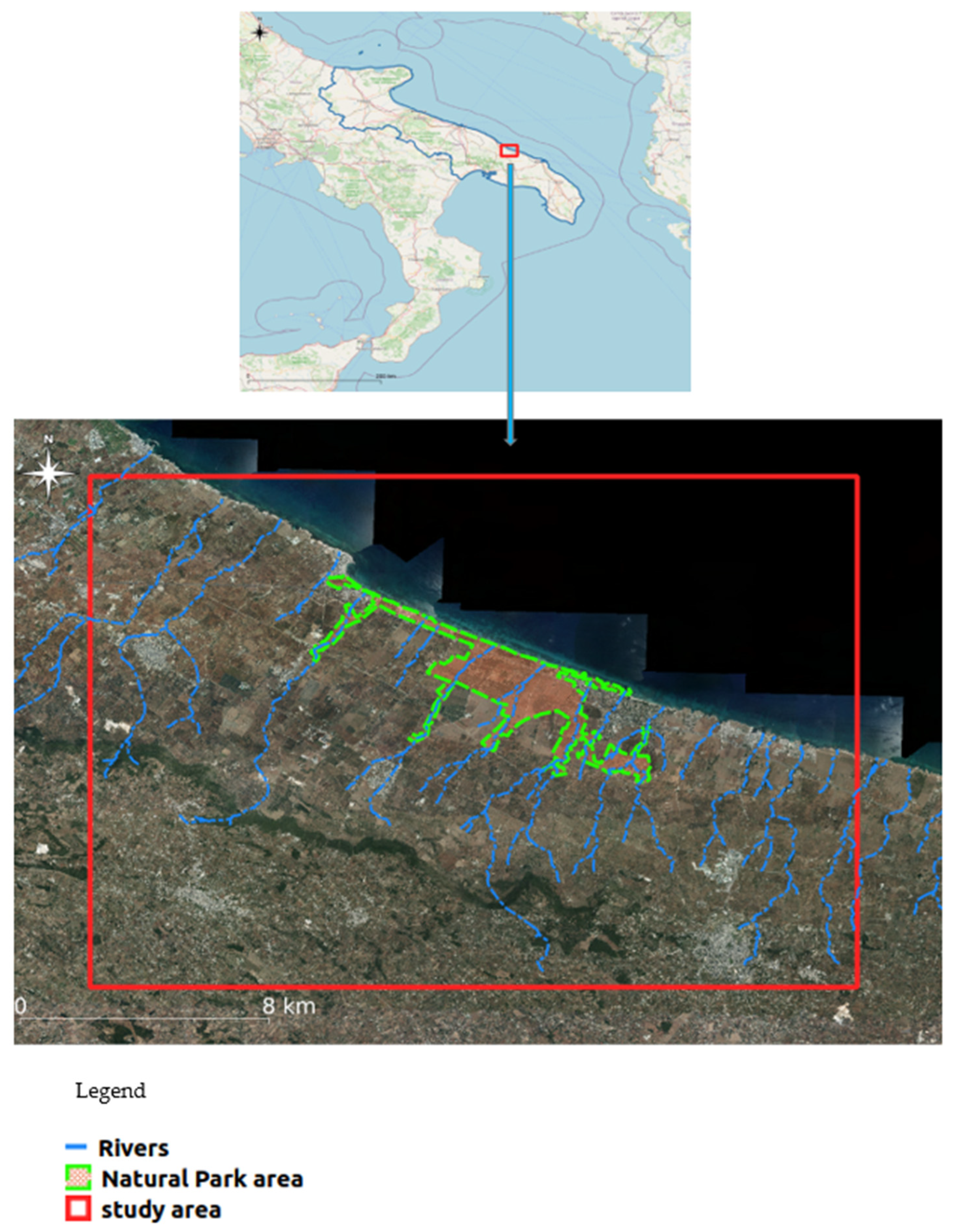
Figure 1. Extension of the Dune Costiere Regional Natural Park and study area.
Urbansci 08 00169 g001
Figure 2. Land use map of the entire study area.
Urbansci 08 00169 g002
Figure 3. The data processing workflow for the identification of the necessary and most suitable ecological corridors (Least cost path algorithm from [57]; output picture from [58]).
Urbansci 08 00169 g003
Figure 4. Map of green area locations (centroids).
Urbansci 08 00169 g004
Figure 5. Movement cost map of the study area.
Urbansci 08 00169 g005
Figure 6. Map of the most suitable areas for acting as ecological corridors.
Urbansci 08 00169 g006
Table 1. Friction values assigned by land use type.
Land Use CodeTypologyFriction Value
1.1Agricultural use: Arable land30
1.2Agricultural use: Forage30
1.3Agricultural use: Permanent crops30
1.4Agricultural use: Agroforestry areas10
1.6Agricultural use: Other agricultural areas30
2Forestry use5
3Mining areas90
4Urban areas100
5Water uses2
6.1Non-economic uses: Wetlands1
Disclaimer/Publisher’s Note: The statements, opinions and data contained in all publications are solely those of the individual author(s) and contributor(s) and not of MDPI and/or the editor(s). MDPI and/or the editor(s) disclaim responsibility for any injury to people or property resulting from any ideas, methods, instructions or products referred to in the content.