1. Introduction
Wetlands worldwide hold great importance, despite representing only 3% of the Earth’s surface, as they maintain ecological balance and ensure the well-being of species inhabiting this ecosystem. In addition to improving water quality and benefiting aquatic ecosystems, they are essential for scientific research and environmental education [
1].
Therefore, it is necessary to promote environmental education, responsible tourism, and biodiversity conservation. In the field of urban planning, green corridors are vital for creating sustainable and resilient urban environments while also promoting conservation and respect for nature. An example of this is Benjakitti Forest Park (
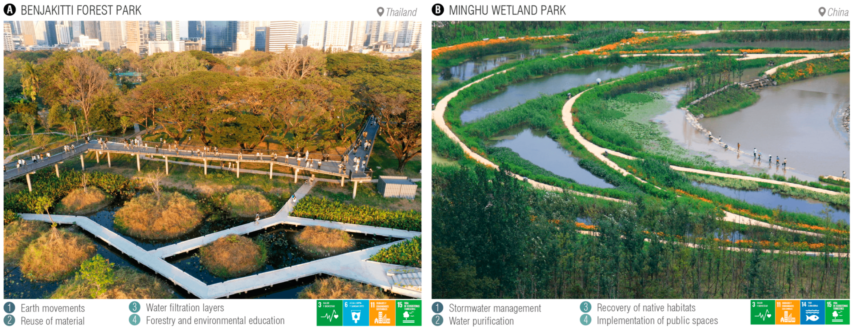
Figure 1A), the design of which aimed to enhance understanding and knowledge of ecology, forestry, hydrology, and the environment by employing strategies such as sustainable mobility, water management, prioritizing environmental education, and community participation [
2]. In this case, Sustainable Development Goals (SDGs) such as Good Health and Well-being (SDG 3), Clean Water and Sanitation (SDG 6), Sustainable Cities and Communities (SDG 11), and Life on Land (SDG 15) were applied [
3]. Another example of urban interventions contributing to the development of protected natural environments is Minghu Wetland Park (
Figure 1B), which was planned to provide ecosystem services through strategies such as stormwater management, water purification, and native habitat restoration, resulting in a positive effect on the community by achieving biodiversity recovery, retention of local customs, improvement in rainwater quality, and public access to planned spaces within the park [
4]. This also involves the implementation of SDGs such as Good Health and Well-being (SDG 3), Sustainable Cities and Communities (SDG 11), Life Below Water (SDG 14), and Life on Land (SDG 15).
As a third case of an ecosystem regeneration project, we have Gorka Rogowska in Lodz, located in Central Poland, once a region heavily affected by pollution. This extensive recreational area of approximately 600 hectares stands as an exceptional paradigm of regeneration, transforming from degraded land into a thriving sports and leisure field. This vast space not only represents a significant transformation but also holds crucial importance for the entire region, particularly for the metropolitan area of Upper Silesia [
7]. This project also incorporates the implementation of SDGs such as Good Health and Well-being (SDG 3) and Sustainable Cities and Communities (SDG 11). Lastly, as the final case, we present the landscape along the Vistula River in Poland, where environmental preservation can generate positive impacts on economic development, human well-being, and quality of life for future generations and highlights the intrinsic value of nature. The main challenges for biodiversity conservation include the lack of awareness among users of natural resources, limited understanding of the value of limited resources, and excessive economic pressure. In this regard, respondents are queried about their knowledge of the Vistula River in Warsaw, highlighting it as a unique example of an unregulated river flowing through a heavily urbanized area in Europe [
8]. Also, in this case, several Sustainable Development Goals (SDGs) are applied, such as Good Health and Well-being (SDG 3), Clean Water and Sanitation (SDG 6), Sustainable Cities and Communities (SDG 11), and Life on Land (SDG 15).
In
Table 1, it can be observed that each place has its own traditions and customs that contribute to the development of the community and provide people with a sense of belonging, as seen in the study on “wetland spirits and Indigenous knowledge”, which emphasizes the importance of preserving the memory, traditions, and customs of Indigenous peoples, not only as unique cultural expressions but also as fundamental knowledge for the sustainable management of ecosystems [
9].
Within protected areas and wildlife refuges, we have wetlands, which are a type of ecosystem characterized by being permanently flooded. Because of this, they have a different microclimate due to the high humidity in these places, thus presenting unique flora and fauna species [
10]. Additionally, these ecosystems play a role in reducing water pollution, capturing carbon, and obtaining products that can be used for food [
11]. Due to the great importance of wetlands worldwide, a treaty called the “Convention on Wetlands of International Importance, especially as Waterfowl Habitat”, currently known as “RAMSAR”, has emerged, which plays an important role in the conservation and sustainable use of wetlands, recognizing their value and importance for life on the planet. Collaboration between countries through this convention significantly contributes to the protection of these vital ecosystems [
12].
At the national level, Peru has 14 RAMSAR sites of international importance, 8 of which are protected under the National System of Protected Natural Areas (SERNANP). Additionally, Peru ranks third in South America in terms of protected wetland areas according to RAMSAR [
13]. Likewise, having direct access to the sea, it has coastal wetlands, which serve as links between terrestrial and marine ecosystems, playing a fundamental role in climate change mitigation and adaptation [
14].
Despite having the smallest extension, Villa Marshes, classified as a coastal wetland, is the only RAMSAR site in Metropolitan Lima, as well as being a significant global hub for bird migration with two main routes: Pacific Americas and Central Americas. In particular, during the summer months (November and December), between 15,000 and 20,000 flocks of birds from the Northern Hemisphere can be observed, continuing their route toward the southern part of the country [
15]. So far, 210 species of avifauna (including migratory, resident, and occasional records) have been recorded [
16].
The importance of Villa Marshes is evident in the benefits they provide both to the environment and the local community. These wetlands are crucial as natural regulators, contributing to flood control and improving water quality through filtration processes [
17]. Additionally, they act as carbon sinks, significantly contributing to climate change mitigation [
18]. From a socioeconomic perspective, Villa Marshes is essential for artisanal fishing and serves as an educational resource for environmental awareness. Preserving Villa Marshes not only aids in biodiversity conservation but also ensures the continued provision of necessary ecosystem services for environmental balance and community well-being.
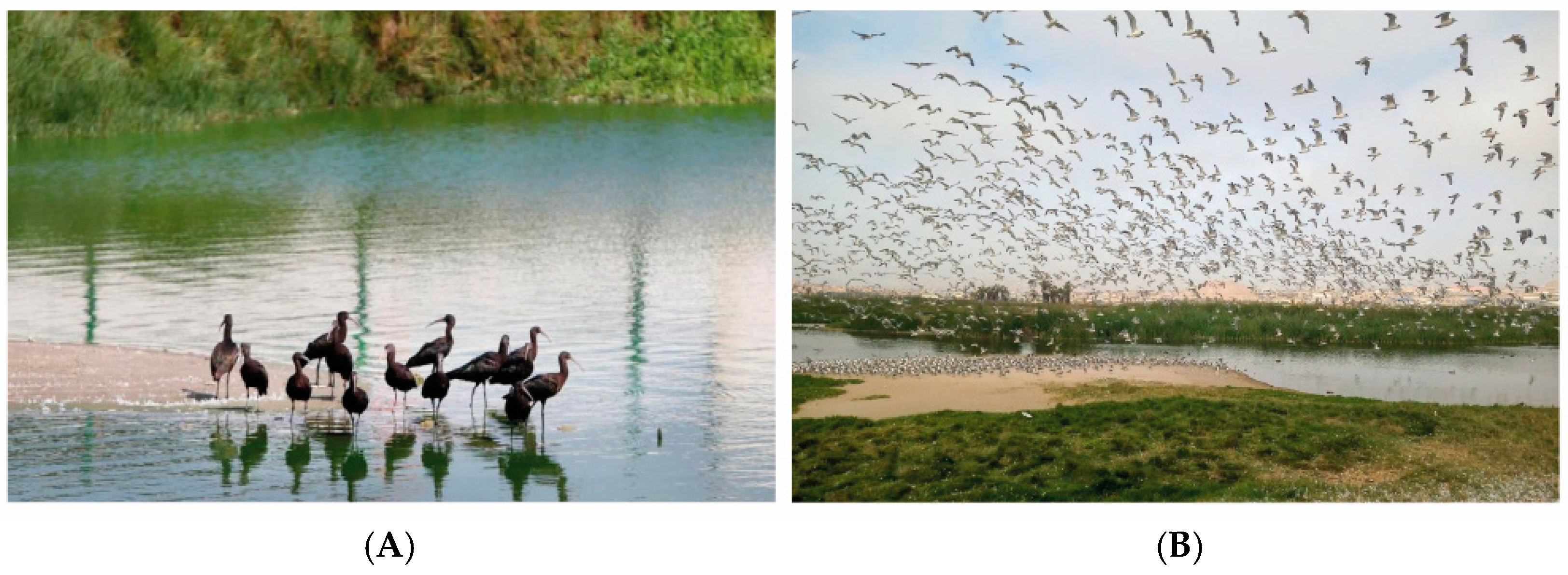
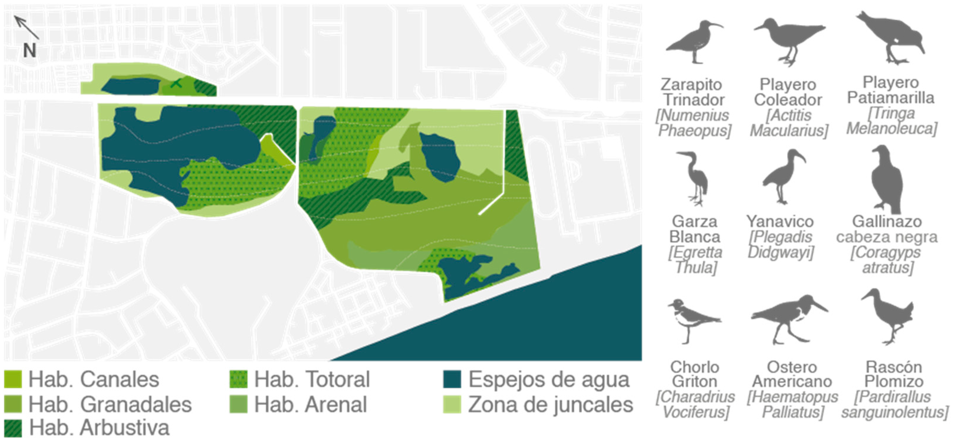
Furthermore, these wetlands offer vital habitats for the reproduction, feeding, and resting of migratory and resident birds (
Figure 2). Shallow water areas and aquatic vegetation provide ideal conditions for nesting, while the diversity of aquatic species ensures a rich food source. These ecosystems not only host a varied array of species but also play a strategic role for migratory birds, providing them with a safe haven to rest during their long journeys. The conservation of Villa Marshes not only ensures the survival of these birds but also contributes to the health of aquatic ecosystems, promoting environmental balance and providing opportunities for birdwatching and environmental education [
19].
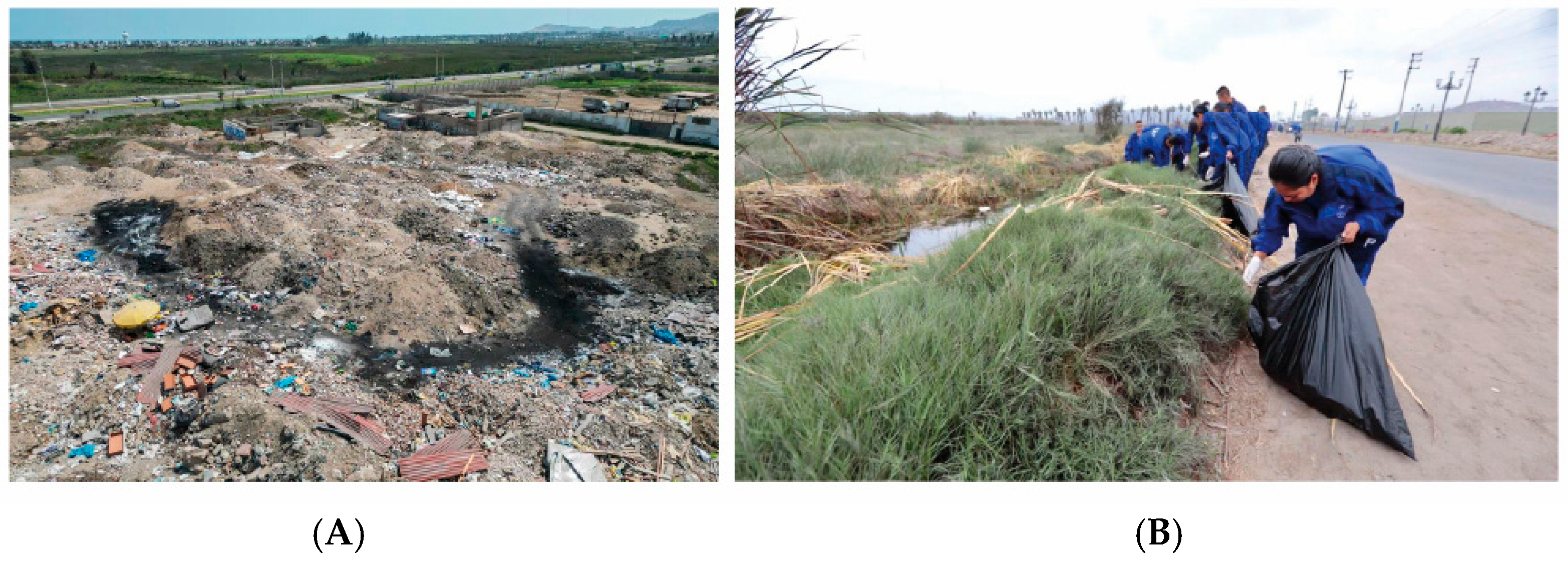
However, Villa Marshes is not exempt from problems that affect the area, despite the significance it holds both nationally and globally. From an environmental standpoint, these wetlands face threats such as water contamination caused by the discharge of untreated wastewater from human activities such as agriculture, industry, and nearby urban settlements. This pollution introduces toxic chemicals and pathogens, threatening water quality and aquatic life. The accumulation of solid waste, such as plastics and household refuse, poses another persistent issue. These wastes can disrupt aquatic ecosystems, affect birds and other organisms, and contribute to overall environmental degradation (
Figure 3). Urban growth around the marshes has exacerbated the damage caused by this situation, resulting in a greater load of contaminants from oils, heavy metals, and chemicals. Additionally, soil erosion, associated with deforestation and soil degradation in the surrounding areas, contributes to sedimentation in the marshes, negatively impacting water quality and affecting this ecosystem [
22].
From an urban perspective, due to the ongoing pressure of urban expansion in Lima, the growing population, and the demand for land for housing construction and infrastructure development, there has been encroachment into the boundaries of this wetland. This phenomenon has resulted in the loss of natural habitats, the fragmentation of the ecosystem, and the degradation of environmental quality. Unplanned urbanization has also contributed to water pollution, the introduction of exotic species, and the alteration of natural patterns, threatening the biodiversity and ecological function of the marshes [
25].
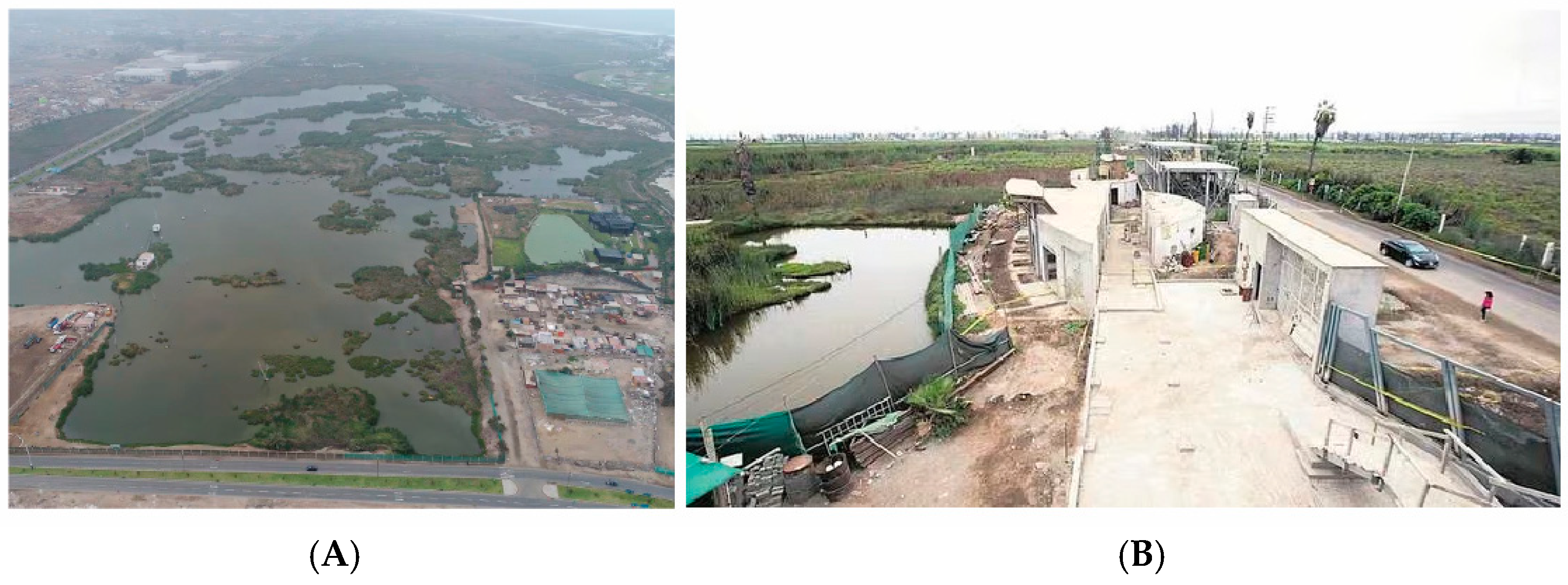
Similarly, they face significant challenges in terms of accessibility that impact the visitor experience and the management of the nature reserve. The lack of adequate infrastructure, such as accessible trails and rest areas, along with unclear signage, creates obstacles for navigation within the reserve. The limited availability of direct public transportation and lack of adapted facilities also affect accessibility, especially for people with disabilities. Traffic management and insufficient information about terrain conditions and routes are additional issues. The rainy season can result in floods, negatively impacting accessibility and safety [
26] (
Figure 4).
From a tourism perspective, the growing tourist interest in this unique ecosystem has led to significant challenges such as congestion during certain times of the year, lack of regulation, and absence of adequate tourist infrastructure. The uncontrolled influx of visitors can result in wildlife disturbance, degradation of sensitive habitats, and pollution of water bodies. Furthermore, unmanaged tourism can contribute to the exploitation of local resources and the loss of local identity. The absence of educational programs on the importance of conservation can also lead to irresponsible practices by visitors [
29].
After identifying the issues, the following problem formulation is proposed:
What is the relationship between uncontrolled urbanization and habitat fragmentation in Pantanos de Villa?
What is the relationship between environmental degradation and biodiversity loss?
How does the implementation of clean energy contribute to the conservation of Pantanos de Villa?
What is the relationship between the lack of adequate infrastructure and the accessibility of green corridors?
This study also aims to resolve these through the following objectives:
Determine the relationship between uncontrolled urbanization and habitat fragmentation in Pantanos de Villa;
Determine the relationship between environmental degradation and biodiversity loss;
Determine how the implementation of clean energy contributes to the conservation of Pantanos de Villa;
Determine the relationship between the lack of adequate infrastructure and the accessibility of green corridors.
Hence, the present research aims to propose a sequence of green corridors and related facilities for the study of avifauna and environmental education aimed at raising awareness for biodiversity preservation in “Pantanos de Villa” in the year 2023.
2. Materials and Methods
2.1. Methodological Scheme
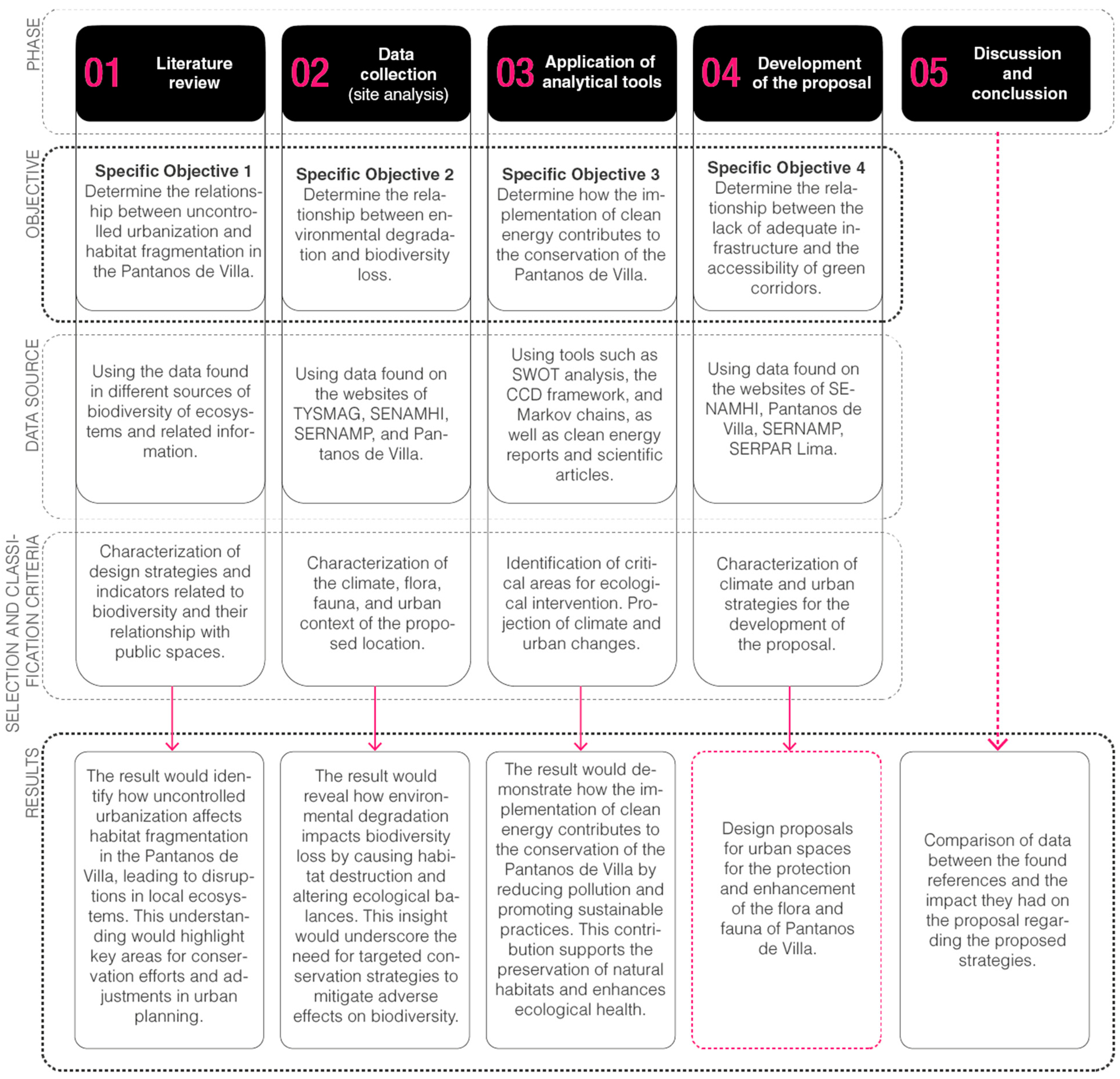
The present research was non-experimental in nature, beginning initially with information gathering, followed by data collection related to the topic for analysis and proper classification. Finally, the architectural proposal was formulated based on the use of appropriate design strategies with the aim of achieving the desired objective.
In
Figure 5, the research phases are outlined. The process began with a literature review in Phase 1, using various data sources on biodiversity and habitat fragmentation in Pantanos de Villa. In this phase, we characterized design strategies related to biodiversity and their connection to public spaces. Phase 2 involved data collection from reliable sources such as SENAMHI, TYSMAG, and SERNAMP, aiming to analyze the relationship between environmental degradation and biodiversity loss while characterizing the climate, flora, fauna, and urban context of the proposed area. In Phase 3, analytical tools like SWOT analysis, the Markov chain, and the CCD framework were applied to identify critical areas for ecological intervention, projecting climate and urban changes. The implementation of clean energy and its contribution to the conservation of Pantanos de Villa was also explored. Phase 4 focused on developing design proposals that incorporated green corridors and urban spaces to protect local flora and fauna. Finally, in Phase 5, we compared the collected data with existing references, assessing the impact of the proposed strategies in addressing the initial problem. The overall objective of the process was to propose designs that promote ecosystem and biodiversity conservation in Pantanos de Villa, particularly through green infrastructure and clean energy implementation.
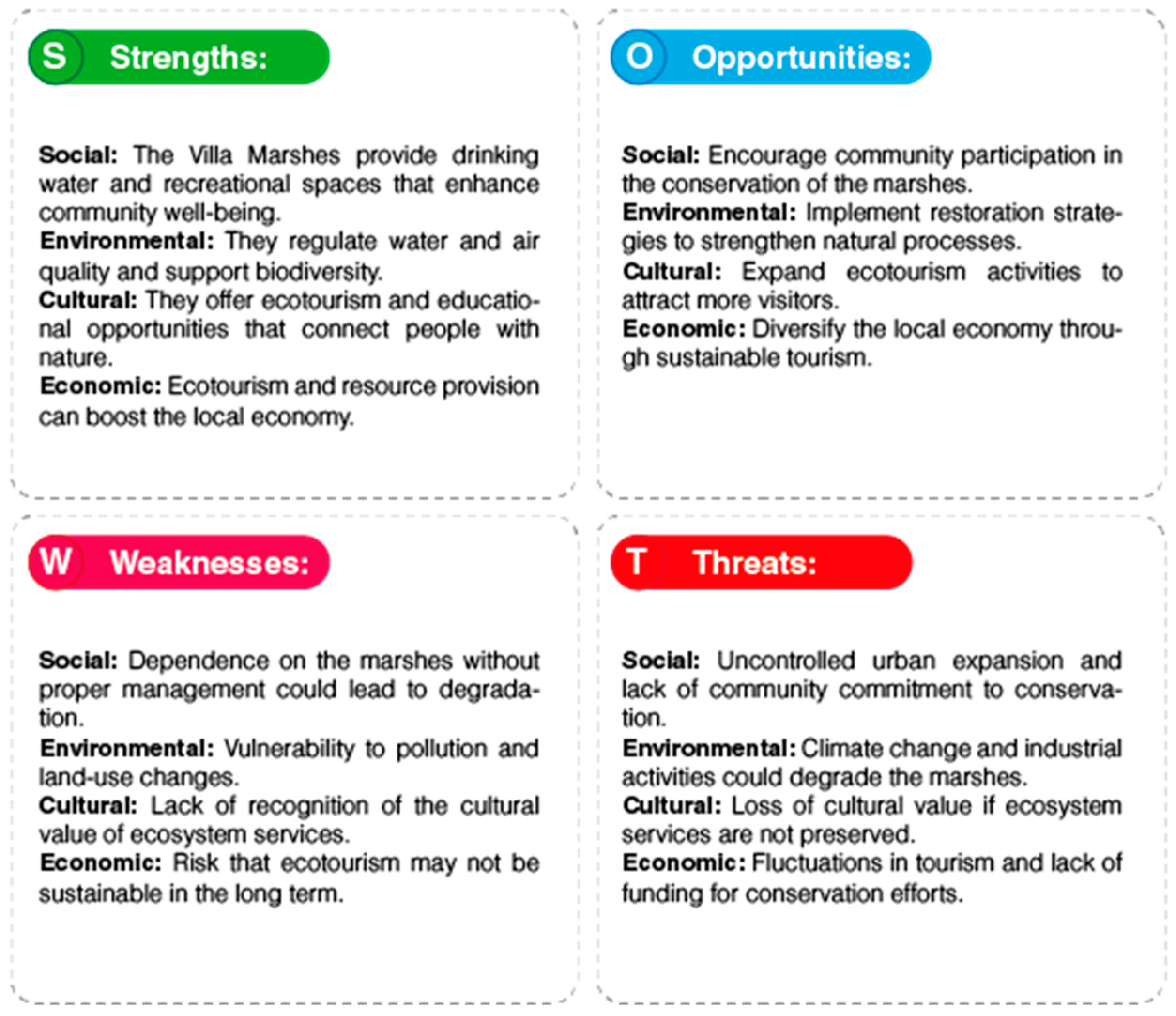
SWOT Analysis
As shown in
Figure 6, the analysis of the ecosystem services of Villa Marshes indicates that proper management can enhance water and air quality, support biodiversity, and improve community well-being. However, inadequate management could lead to ecosystem degradation, affecting its ability to regulate the environment and provide resources. Vulnerability to pollution and land use changes, along with a lack of cultural recognition and the risk of unsustainable ecotourism, may reduce these benefits. Therefore, implementing conservation strategies is crucial to maximize benefits and minimize losses.
2.2. Study Area
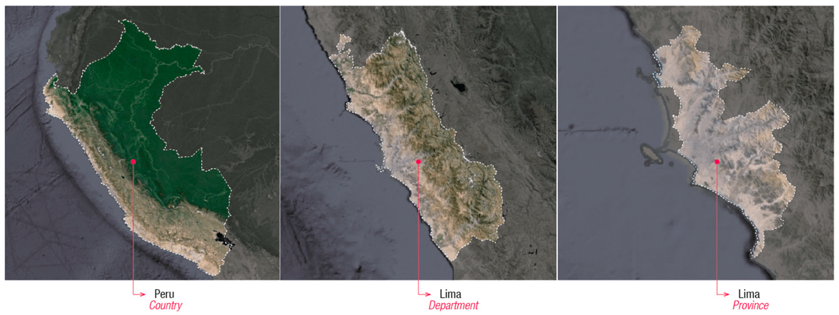
In
Figure 6, the study area corresponding to Pantanos de Villa is diagrammed, located on the central coast of Peru, specifically in Chorrillos, an important district of the capital of Peru. It is emphasized that this place encompasses marine areas, urban areas, and areas with vegetation, and is also an area that hosts protected zones, such as Pantanos de Villa.
2.3. Climate Analysis
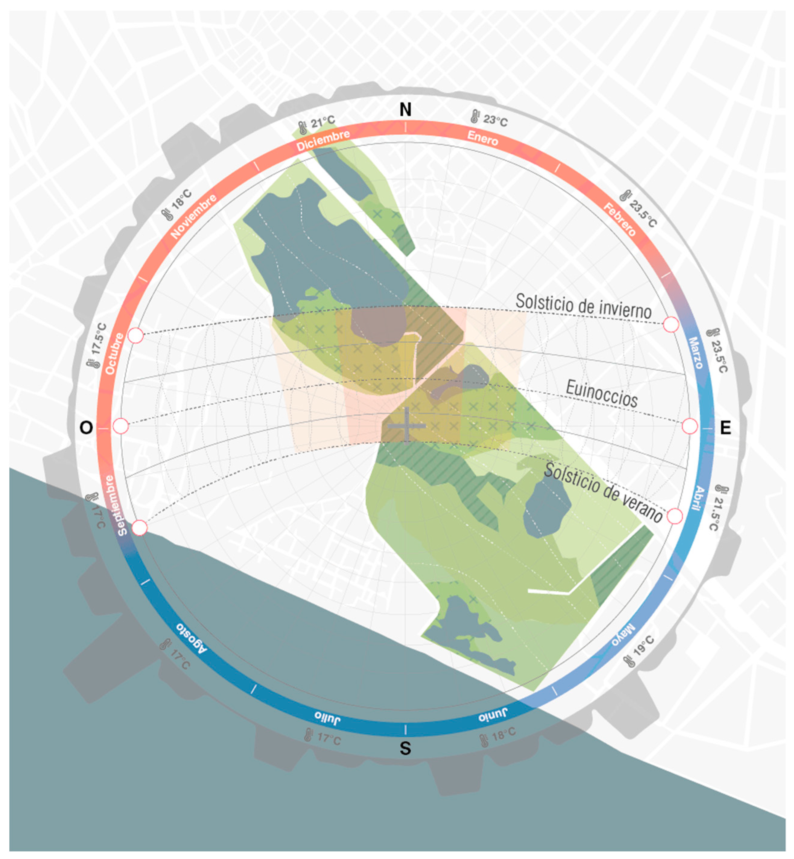
The high-pressure system in the South Pacific generates a considerable layer of stratiform clouds extending from 150 to 1000 m altitude. This results in low precipitation and the predominance of south winds, with average speeds of 3 m/s. These winds, combined with the Peruvian Current, contribute to the formation of the characteristic fog in the region. Typical wind directions are from the south to southeast, giving rise to local winds that move from sea to land during the day and from land to sea at night. (
Figure 7).
During the spring and summer seasons, the sky remains clear, with generous solar radiation and temperatures fluctuating between 15 and 26 °C, accompanied by low precipitation. In contrast, during winter and autumn, temperatures drop, ranging between 14 and 19 °C, with more diffuse and indirect solar radiation. The relative humidity varies between 85 and 99%, and precipitation can reach up to 60 mm during the winter months. The approximate temperature values in the Lima area, including Villa Marshes, reveal that the months with the lowest temperature at 12 °C are from June to August, and the highest temperatures are at 24 °C from November to March. The location of Villa Marshes mostly experiences low cloudiness and a small amount of precipitation. However, it is noted that despite these conditions, there is a shortage of sunshine during some months, and the area tends to remain partially cloudy mostly, with cloudiness levels recorded in Villa Marshes from October to April [
30].
2.4. Environmental Analysis: Flora and Fauna
Villa Marshes constitute an important ecosystem that harbors unique biological diversity and contributes significantly to the environmental health of the region. From an environmental standpoint, these marshes are crucial in water regulation and flood mitigation, acting as natural sponges that absorb and retain excess water during periods of heavy rainfall. This ecosystem service is essential for protecting surrounding communities against extreme weather events while promoting water quality by filtering sediments and contaminants (
Figure 8).
The flora of Villa Marshes presents a variety of species adapted to wet conditions, including reeds, rushes, and various aquatic herbs. These plants contribute to soil stabilization and the provision of suitable aquatic habitats for diverse forms of life. Additionally, the diversity of fauna in this environment includes migratory birds such as ducks and herons, which find refuge and food in these wetlands. Similarly, native fish and amphibians contribute to the food chain, enriching biodiversity and sustaining the healthy dynamics of the ecosystem.
However, Villa Marshes face significant threats such as uncontrolled urbanization and water pollution, which compromise the integrity of this valuable ecosystem. The preservation and sustainable management of these wetlands are vital to ensuring the continuity of their environmental benefits, as well as the conservation of the flora and fauna that depend on this unique environment [
31].
2.5. Development and Urban Growth in Pantanos de Villa
Figure 9 diagrams the graphical development of the study area corresponding to Villa Marshes, dating from 1941 to the present day, highlighting the degradation of the natural marsh ecosystem due to unregulated urban growth [
32].
In
Figure 9, it can be observed that, initially, this coastal ecosystem was an extensive area of wetlands, mangroves, and lagoons, serving as a refuge for varied fauna and flora. However, over the decades, urban growth and the expansion of Lima city have exerted significant pressure on this natural space, causing the degradation of its environment and loss of biodiversity [
33].
Furthermore, the overexploitation of natural resources in Villa Marshes, such as indiscriminate fishing and mangrove logging, has contributed to the degradation of this coastal ecosystem. The lack of effective regulations and the limited implementation of conservation measures have exacerbated these problems, endangering the biodiversity and functionality of the marshes. Collectively, these disadvantages represent significant challenges for the long-term conservation of Villa Marshes and underscore the need for more sustainable and balanced environmental management in the region [
34].
2.6. Ecosystem Services
Ecosystem services refer to the various benefits that humans obtain from natural environments. These services are categorized into four main types, namely provisioning services, which supply resources such as food, water, and raw materials; regulating services, which involve the control of natural processes such as climate regulation, water purification, and air quality; supporting services, which are essential for maintaining the conditions for life on Earth, such as nutrient cycling and habitat formation; and cultural services, which provide non-material benefits like recreation, education, and spiritual well-being. Understanding and preserving these services is crucial for sustainable environmental management and community well-being.
In the context of the proposal for Villa Marshes, ecosystem services are essential for improving and sustaining the environment, directly aligning with the study objectives mentioned earlier. From a provisioning perspective, the marshes could provide essential raw materials and serve as a significant source of drinking water, thus contributing to the community’s basic needs. This aligns with the first objective, which seeks to determine the relationship between environmental degradation, biodiversity loss, and the implementation of clean energy. By ensuring the availability of resources like water, the negative effects of environmental degradation are mitigated.
In terms of regulation, the marshes are vital in regulating both water and air, acting as a natural filter that enhances water quality and contributes to air purification. These regulating services support the second objective of the study, which involves the analysis of the relationship between uncontrolled urbanization and habitat fragmentation and how clean energy can mitigate these impacts. By preserving the marshes’ capacity to regulate water and air, the negative effects of urbanization and fragmentation are counteracted.
In the realm of support, the marshes play a fundamental role in the nutrient cycle and photosynthesis, contributing to the balance and health of surrounding ecosystems. Additionally, restoration strategies could be implemented to strengthen these natural processes and enhance biodiversity, which aligns with the third objective, aimed at evaluating the relationship between the lack of adequate infrastructure, the accessibility of green corridors, and the role of clean energy in improving these conditions.
From a cultural perspective, the proposal provides the community with ecosystem services that promote ecotourism, offering educational and recreational opportunities that connect people with nature. Furthermore, there would be a recognized positive impact on the community’s mental health, providing natural spaces for recreation and emotional well-being. These cultural benefits align with the overall objectives of the study, as they foster greater awareness of the importance of wetland and biodiversity conservation while promoting sustainable practices through the use of clean energy and the creation of adequate infrastructure [
35].
3. Results
3.1. Proposal Location
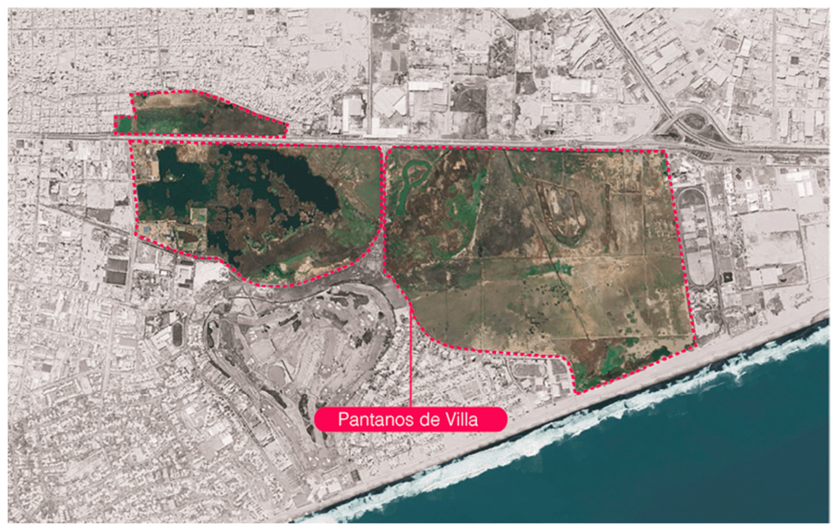
Villa Marshes is located in the district of Chorrillos, in the city of Lima, Peru. This coastal wetland ecosystem covers an area of approximately 263 hectares and is situated in a strategic zone between the coast and the city. Bounded by the Pacific Ocean to the west, Villa Marshes serves as a vital green belt that separates urbanization from the coastline, acting as a natural lung and a refuge for biodiversity amidst a constantly expanding urban environment. Its strategic location not only provides environmental benefits such as water regulation and preservation of native flora and fauna but also offers the local community and visitors a unique space for recreation and connection with nature.
In
Figure 10, the various geographical elements of the site are presented. To the west, it extends to the shores of the Pacific Ocean, providing a vital coastal habitat. To the east, it borders the urban areas of Chorrillos, marking a transition between the natural environment and urban expansion. Additionally, it has defined northern and southern boundaries through local geographical features such as roads and developed areas. These physical limits outline the area of Villa Marshes, highlighting its importance as a coastal ecosystem in the context of a constantly growing city.
3.2. Conceptualization of the Proposal
The conceptualization of the proposal is based on the integration and connection of Villa Marshes, aiming to raise awareness among users regarding the importance of this ecosystem. The proposal includes the establishment of environmental education centers and a visitor center strategically located to provide information, awareness, and educational experiences, highlighting the biological richness and ecological function of the marshes. Additionally, the implementation of a network of green corridors that links and traverses the area is proposed, providing visitors with a means to explore and experience the natural beauty of the marshes sustainably. This physical and educational integration seeks not only to preserve and protect this valuable coastal ecosystem but also to foster a deeper connection between the community and nature.
To ensure the effective implementation of green corridors in Pantanos de Villa, it is essential to develop and apply concrete policies that address various key aspects. First, land use regulation through environmental zoning can ensure that critical areas for conservation and green corridors remain free from harmful developments. Construction regulations should promote sustainable practices and limit development in these areas. Additionally, economic incentives such as subsidies and funding for restoration and maintenance projects, along with tax benefits for those involved, should be established. Education and awareness play a crucial role; educational programs and campaigns are needed to inform the community about the importance of green corridors and encourage their participation in managing these spaces. Integrated planning and management should incorporate green corridors into regional development plans, with monitoring and evaluation mechanisms to ensure their effectiveness. Finally, legal protection is essential to ensure that areas designated for green corridors are protected by environmental laws and restoration policies, guaranteeing their ecological integrity in the long term. These policies not only facilitate the creation and maintenance of green corridors but also promote a harmonious balance between ecosystem conservation and sustainable regional development.
3.3. Urban and Environmental Analysis
This analysis provides a comprehensive understanding of the interaction between the natural environment and the surrounding urban activities. By evaluating urban planning, road infrastructure, and zoning, opportunities to preserve and enhance ecosystems can be identified, ensuring harmonious coexistence between urbanization and biodiversity.
Furthermore, a detailed environmental analysis is crucial for assessing the health status of ecosystems in Villa Marshes. It allows for the identification of potential threats such as pollution, habitat loss, and the impact of human activities, thereby contributing to the implementation of conservation and restoration measures. This integrated approach not only safeguards local biodiversity but also promotes environmental education and public awareness of the importance of conserving these natural spaces.
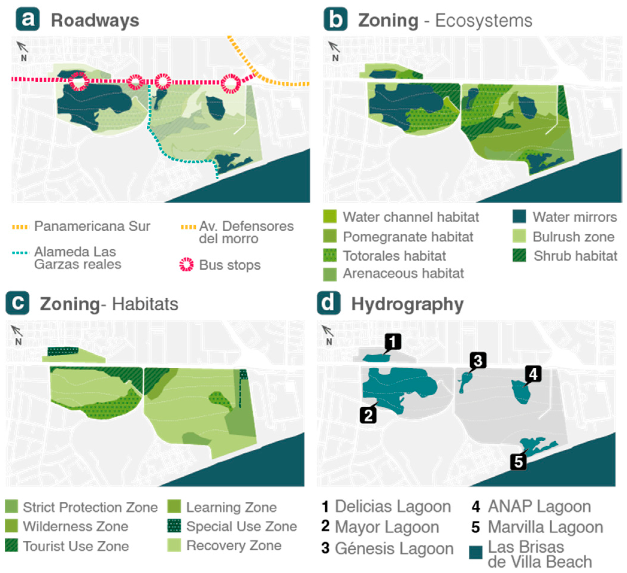
In
Figure 11, the traffic analysis explains the issue generated by vehicular congestion between main roads, which creates nodes of higher visitor influx, in addition to the problem of accessibility to Villa Marshes due to the main trail that crosses it.
The ecosystem zoning presents a great diversity of areas with different flora and fauna species, which enriches Villa Marshes, in addition to delineating areas of strict protection, necessary for the proper care of these species. The habitat zoning shows the variety in terms of differentiated endemic flora for each zone, such as the habitats of reeds and shrubs, which were developed in completely different zones under the same environment.
Finally, the hydrographic analysis is characterized by a complex network of water bodies that include lagoons, channels, and interconnected estuaries. These marshes harbor a diversity of aquatic environments, such as mangroves and reeds. The presence of these aquatic formations contributes to the ecological richness of the area, providing unique habitats for various species of flora and fauna adapted to saline environments and transitions between terrestrial and marine environments.
3.4. Urban Design Strategies
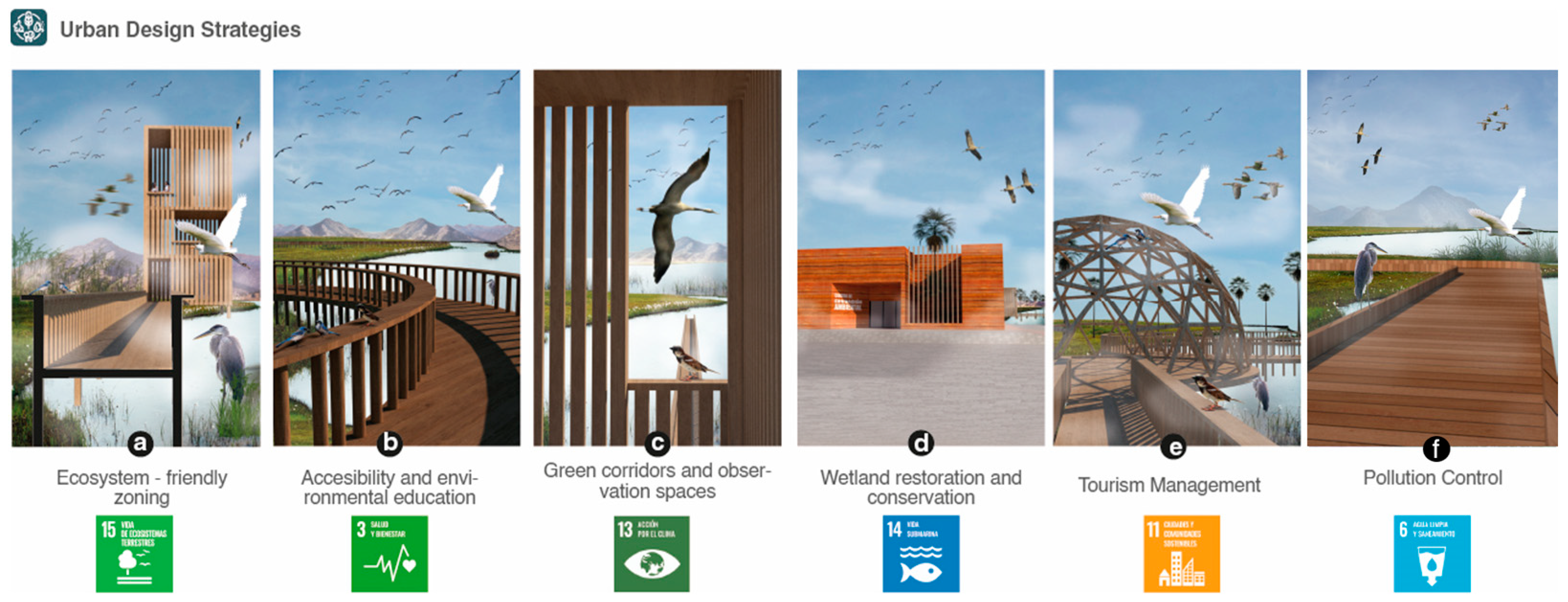
The proposed design strategies for Villa Marshes focus on ensuring respectful ecosystem zoning, wetland restoration and conservation, accessibility and environmental education, pollution control, creation of green corridors, and implementation of observation spaces, as well as sustainable tourism management.
As shown in
Figure 12, ecosystem-friendly zoning involves identifying specific areas within the marshes that require different levels of protection and management, ensuring the preservation of habitats and biological diversity. Wetland restoration and conservation focus on rehabilitating degraded areas and implementing measures to protect water quality and maintain wetland health, contributing to biodiversity and ecological function. Accessibility and environmental education aim to ensure that visitors have access to educational information about the importance of wetlands and how they can contribute to their conservation. This is achieved through educational trails, informative panels, and awareness programs. Pollution control involves implementing practices and regulations to minimize the introduction of contaminants into the area, ensuring water quality and ecosystem integrity. The creation of green corridors and observation spaces is geared toward planning routes and specific areas that allow people to enjoy the natural beauty of the marshes while minimizing environmental impact. Finally, tourism management focuses on developing sustainable strategies that balance the tourist experience with environmental conservation, limiting pressure on the ecosystem and promoting nature-friendly practices.
As shown in
Figure 13, the proposed design strategies for Villa Marshes are oriented toward the preservation and valorization of this unique ecosystem. Ecosystem-friendly zoning, wetland restoration, educational accessibility, pollution control, and the creation of green corridors and observation spaces, along with sustainable tourism management, are combined to ensure a harmonious coexistence between biodiversity conservation and visitor experience. These measures not only aim to protect the hydrography and flora and fauna of the marshes but also promote environmental awareness and the active engagement of the community and visitors in the preservation of this valuable ecosystem.
In addition to the strategies mentioned, the proposed design for Villa Marshes incorporates sustainable mobility solutions to minimize environmental impact. This includes developing low-impact transportation options, such as walking paths, cycling routes, and electric shuttles, to facilitate access while protecting the marshes. The use of local materials for construction helps reduce environmental disruption and supports local economies. Additionally, integrating clean energy sources, like solar and wind power, into the design will decrease reliance on fossil fuels and lower the carbon footprint. These measures enhance the overall design and functionality of the marshes, ensuring that development supports both environmental sustainability and community engagement.
3.5. Master Plan
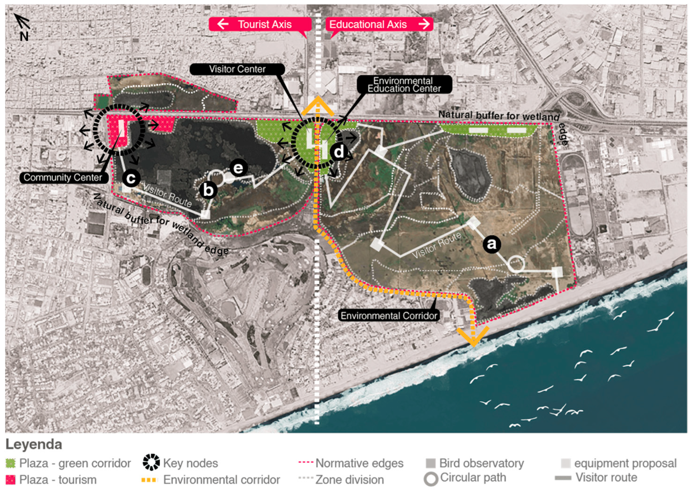
The proposal for Villa Marshes is based on the central axis, which divides Villa Marshes into two sectors: the tourist sector and the educational sector. In the tourist sector, priority is given to elevated pathways for the proper development of species, fostering environmental awareness among visitors. Additionally, there is a presence of a visitor center and a community center, which contribute to raising awareness among users about the importance of Villa Marshes. In the educational sector, the focus is primarily on providing a route for the study of bird development and species of flora and fauna, along with proposing an environmental education center.
The master plan demonstrates the distribution of spaces in accordance with urban design strategies and ecosystem services, creating observation spaces that respect the ecosystem, utilizing local materials and labor, and promoting wetland conservation and the creation of green corridors with proper tourism management (
Figure 14).
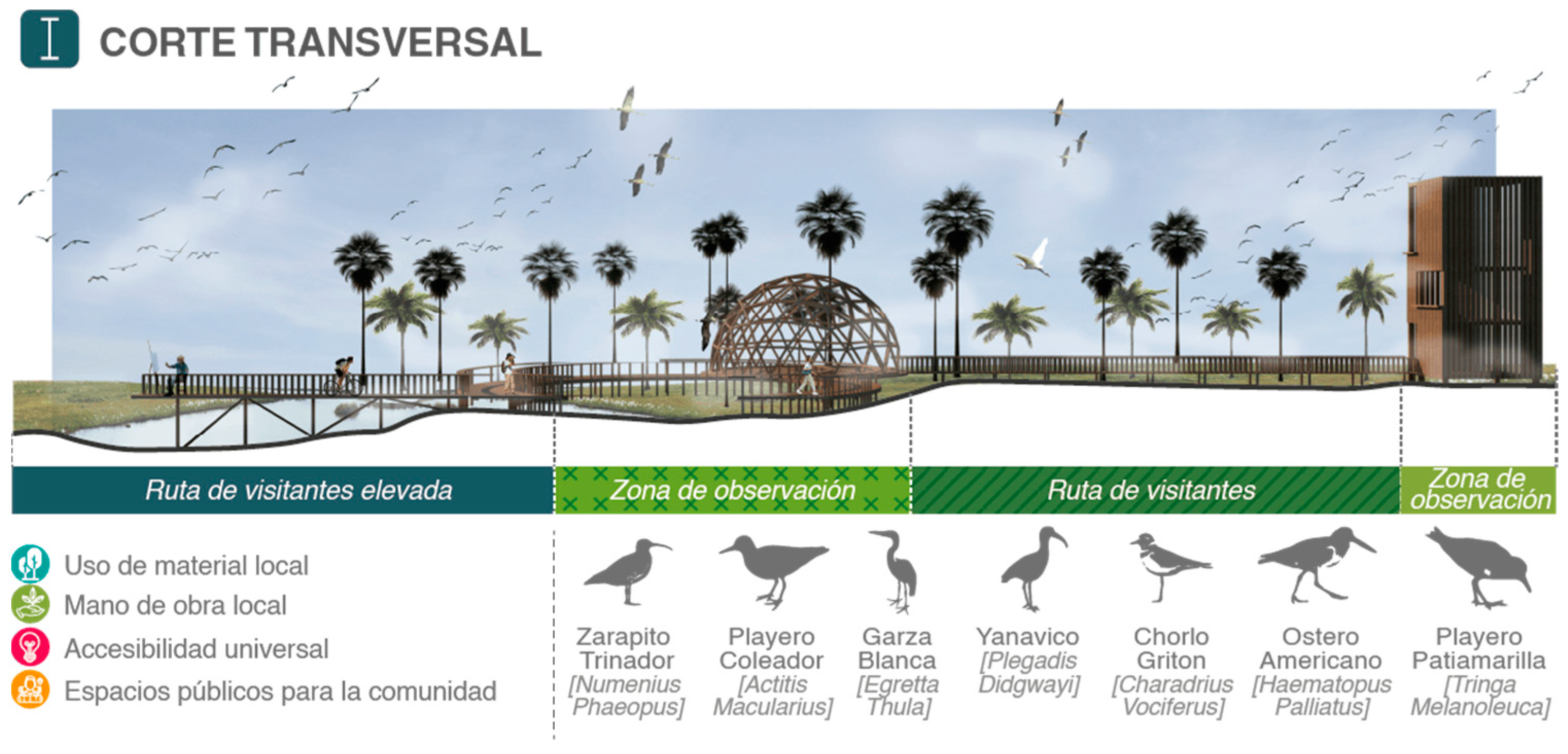
In
Figure 15, the cross-section illustrates both the proposal for elevated pathways and observation spaces such as the dome and the birdwatching tower, as well as the surrounding environment of the proposed urban area, including elevated pathways for visitors, observation areas including points of universal accessibility, and strategies highlighting respect for the ecosystem.
The relationship between the wetlands in the area and the proposed accessibility for tourists is shown. These elevated pathways traversing the marshes are constructed with local materials and labor, following sustainability guidelines, ecosystem services, and the Sustainable Development Goals (SDGs).
Through analysis, a design strategy was developed to facilitate the coexistence between urbanization and biodiversity, promoting conservation through respectful zoning, wetland restoration, environmental education, pollution control, and sustainable tourism management. This approach aims to not only preserve essential ecosystem services such as provisioning and regulation but also foster a deeper connection between the community and nature.
The master plan, structured into tourist and educational sectors, represents a balanced vision incorporating elevated pathways, visitor centers, and green corridors, thus ensuring the conservation of the marshes and providing enriching experiences for visitors and residents. This contributes significantly to the environmental and cultural sustainability of the region.
3.6. Clean Energies
The clean energy implementation proposal, through solar panels and vertical wind turbines, was designed not only to optimize the use of renewable resources but also to address specific environmental challenges in Pantanos de Villa. The use of these technologies significantly contributes to reducing carbon emissions, mitigating environmental degradation, and supporting the conservation of local biodiversity. By integrating clean energy systems into green infrastructure, the project promotes more sustainable urban development that counters the negative effects of uncontrolled urbanization and habitat fragmentation. Additionally, the incorporation of autonomous solar-powered luminaires enhances the accessibility and functionality of green corridors, facilitating their use and maintenance without relying on conventional electrical grids. This approach not only strengthens the existing infrastructure but also ensures that green corridors remain accessible and safe, thus fostering greater connectivity and sustainability in the urban environment.
The proposal utilizes clean energies such as solar and wind power. Solar energy is harnessed through solar panels mounted on the luminaires placed along the proposed route. However, the focus is primarily on the use of wind energy through vertical wind turbines. This is because vertical and horizontal wind turbines represent two distinct approaches to wind power generation. Horizontal wind turbines, which are more commonly used, have a horizontal axis and rotate like a traditional windmill. They are known for their higher efficiency and ability to generate more power at greater heights. In contrast, vertical wind turbines have a design where the blades rotate around a vertical axis. While they are often more compact and can operate with winds from any direction, their overall efficiency is generally lower than horizontal turbines.
In terms of space requirements, vertical turbines are often considered more suitable for urban environments and areas with space limitations as they occupy less ground space. However, horizontal turbines tend to be more effective in open environments and areas with consistent and high-speed winds. Maintenance requirements also differ, as horizontal turbines are typically easier to maintain and repair due to their more conventional design and easy access to mechanical parts [
36].
Vertical wind turbines generally have lower efficiency than the more common horizontal wind turbines. While horizontal turbines typically have efficiencies exceeding 40% under ideal conditions, vertical turbines typically exhibit efficiencies ranging from 20% to 30%, although some designs may achieve higher figures.
Wind speed is a crucial factor, as wind power is proportional to the cube of the wind speed. Therefore, locations with stronger winds tend to better harness the potential for wind power generation [
37].
The basic equation for calculating wind power (P) in a vertical-axis wind turbine is as follows:
where P is the wind power, A is the swept area of the blades, ρ is the air density, and V is the wind speed [
38].
Solar Panels
Solar panels in lights within a green infrastructure proposal have several characteristics [
39], which include the following:
Sustainability: they use renewable and clean energy from the sun, which reduces dependence on non-renewable energy sources and contributes to the mitigation of climate change [
40].
Energy efficiency: solar panels convert solar energy into electricity efficiently, allowing the luminaires to operate with lower energy consumption [
41].
Low maintenance: once installed, solar panels require little maintenance, reducing long-term operating costs.
Autonomy: by running on solar energy, the luminaires can operate independently of the electrical grid, making them ideal for remote areas or without access to the conventional electrical grid.
Versatility: they can adapt to different urban and rural environments, from parks and gardens to streets and squares, providing environmentally friendly lighting in various contexts.
Landscape integration: solar panels and luminaires can be designed to integrate harmoniously into the natural or built environment, contributing to the aesthetic aspect of the green infrastructure.
In summary, solar panels in luminaires are a sustainable and efficient option for providing lighting in public spaces within a green infrastructure, offering environmental, economic, and social benefits.
Figure 14 shows the implementation of the luminaires with solar pallets along the infrastructure route. The implementation of the luminaires occurs in the five circuits: C1 (plaza—green corridor), C2 (plaza—tourism), C3 (environmental corridor), C4 (normative edges), and C5 (pedestrian path).
C1 has a length of 1.1 km with 44 luminaires implemented with photovoltaic panels;
C2 has a length of 1.1 km with 44 luminaires implemented with photovoltaic panels;
C3 has a length of 4.5 km with 180 luminaires implemented with photovoltaic panels;
C4 has a length of 10.6 km with 424 luminaires implemented with photovoltaic panels;
C5 has a length of 9.7 km with 388 luminaires implemented with photovoltaic panels.
The proposal involves the implementation of a total of 1080 luminaires, which is more efficient than a conventional luminaire.
In
Table 2, the quantity of luminaires required is shown, which is 1088 luminaires with solar panels, achieving an efficiency that exceeds 50%, thereby reducing the impact on the environment.
In
Table 3, the implementation involves an autonomous lighting system to offer a real alternative to the need for providing quality lighting during nighttime hours in roads, public areas, or common areas of the proposal. The luminaire system was designed to directly replace sodium, mercury, and metal halide luminaires, meeting the requirements of Icontec, Retilap, UL, and CE. It offers energy savings of 50% to 80% and a lifespan of over 10 years.
The implementation includes a high-efficiency solar panel with an arm for an LED luminaire, featuring 120 L/w, 120-watt power, 14,400-watt consumption, and automatic on/off functionality. A pre-assembled rack-to-pole solar system suitable for outdoor use (with a battery bank for 3 days of backup operation, control system, protections, connectors, and pole fixings) was developed.
Electrical Characteristics:
Lamp power: 120 w;
Luminous intensity: 14,400 Lm;
Luminous flux: 120 L/W;
Color temperature: 6500 K;
Energy accumulator: deep cycle;
Operation: 12 continuous hours;
Recommended height: 11 to 12 m;
Distance between posts: from 25 to 28 m;
Available in cool white and warm white.
The implementation of solar panels with luminaires involves the installation of photovoltaic systems designed to capture solar energy and convert it into electricity to power the luminaires. These solar panels are highly efficient and achieve up to 23% efficiency in converting solar energy into electricity. They are strategically installed in five circuits where they can receive maximum solar exposure during the day. Once installed, the solar panels capture sunlight and convert it into direct current electrical energy. This energy is then transferred to batteries or stored in an energy storage system for later use, especially during the night or on cloudy days when the availability of sunlight is limited. The luminaires were designed to operate efficiently and reliably, providing illumination when needed without relying on the conventional electrical grid. Additionally, their modular and versatile design allows for installation in a variety of environments, from urban to rural areas, thereby contributing to sustainable lighting and the reduction in non-renewable energy consumption. The implementation of solar panels with luminaires represents an innovative and environmentally friendly solution to meet lighting needs in various environments while promoting the use of clean and renewable solar energy.
Figure 14 shows the implementation of vertical wind turbines in green infrastructure, which involves properly taking advantage of the direction of the winds to generate renewable energy in a sustainable manner. These wind turbines are designed to capture the kinetic energy of the wind from any direction, making them ideal for installation in environments where wind direction can vary [
42].
To carry out this implementation effectively, detailed studies of the wind pattern in the area were carried out, identifying the predominant directions and wind speeds. With this information, strategic locations were chosen for the installation of the wind turbines, ensuring optimal exposure to the wind at all times [
43].
Additionally, the protection of the surrounding natural area was considered, ensuring that the installation of the wind turbines would not cause negative impacts on the local ecosystem. This may involve selecting wind turbine designs that minimize noise and visual disturbance, as well as implementing measures to protect the fauna and flora present in the area. The surrounding green infrastructure can also benefit from this implementation, as wind energy generation contributes to the reduction in greenhouse gas emissions and the promotion of sustainable development. Furthermore, vertical wind turbines can be harmoniously integrated into the landscape, complementing the natural beauty of the environment [
44,
45].
Wind energy stands out as a powerful ally in the fight against climate change that affects our planet. Its use allows for a significant reduction in CO
2 emissions, with the capacity to reduce up to 26 million tons annually in our country [
46]. In the last few decades, namely between 2000 and 2018, the expansion of wind farms in Spain resulted in the mitigation of 353 million tons of CO
2, with a notable achievement in the years 2017 and 2018, where the emission of 51 additional tons of carbon dioxide. Wind energy is distinguished as one of the cleanest energy sources available, achieving a CO
2 emission between 5 and 10 times lower than other renewable sources, such as biomass [
47].
In the green infrastructure, a wind farm will be implemented, which will have 20 wind turbines, allowing for the efficient use of the available natural resources and the generation of a significant amount of clean and renewable energy to supply the needs of the surrounding community.
The CCD model was selected due to its ability to focus energy resources in areas with the highest potential for utilization. This model allows for a precise assessment of the spatial distribution of resources and activities, facilitating the identification of optimal zones for the installation of solar panels and wind turbines. By concentrating resources in specific areas, the efficiency of energy generation is maximized, optimizing the performance of the equipment. Additionally, the CCD model helps to minimize environmental impact by avoiding overload in less suitable areas, ensuring that resources are used effectively and sustainably. This results in more efficient management of renewable resources and a reduction in potential negative impacts on the local ecosystem.
The spatial Markov chain analysis provides an advanced tool for modeling the temporal and spatial variability of environmental conditions, such as wind patterns. This approach allows for the prediction of changes in weather conditions and their impact on the efficiency of wind turbines and solar panels. By incorporating historical data and future projections, spatial Markov chain analysis facilitates adaptive planning that can adjust to fluctuations in the availability of natural resources. This not only optimizes the location and design of installations but also ensures the long-term sustainability of the renewable energy system. The ability to anticipate and adapt to changing conditions is crucial for maintaining the efficiency and effectiveness of the system over time.
Together, the CCD model and spatial Markov chain analysis offer a solid foundation for informed decision-making in the implementation of clean technologies. These methods provide a detailed understanding of the environment and its dynamics, allowing for more precise planning and the effective management of energy resources. The application of these approaches ensures that the proposed strategies are not only efficient and sustainable but also adaptable to environmental variations, contributing to ecosystem conservation and the overall success of the project.
4. Discussion
In the
Section 4, a comparison is made between the proposed interventions for Pantanos de Villa and prior experiences, such as Benjakitti Forest Park and Minghu Wetland Park, highlighting the importance of targeted strategies for improving protected natural environments. Each case offers insights into the specific objectives outlined for the conservation of Pantanos de Villa, demonstrating how global approaches can be adapted to local contexts.
For the first objective, determining the relationship between uncontrolled urbanization and habitat fragmentation in Pantanos de Villa, Benjakitti Forest Park offers relevant strategies. Its emphasis on zoning and green infrastructure to control urban expansion and maintain natural spaces provides a reference for managing habitat fragmentation near urban areas. Similarly, the focus in Rospuda Wetland Nature Park regarding the development of ecological corridors illustrates how habitat connectivity can be maintained, reducing fragmentation and supporting species movement in Pantanos de Villa.
Regarding the second objective, determining the relationship between environmental degradation and biodiversity loss, both Minghu Wetland Park and Biebrza Wetland Nature Park offer critical insights. Minghu’s stormwater management and habitat restoration initiatives directly address environmental degradation, which in turn fosters biodiversity recovery. Likewise, Biebrza’s efforts in wetland restoration highlight the essential role of reversing ecological degradation to restore habitat functions and protect species, particularly migratory birds, an issue highly relevant to Pantanos de Villa.
For the third objective, determining how the implementation of clean energy contributes to the conservation of Pantanos de Villa, the sustainable energy and water management practices at Benjakitti Forest Park demonstrate the potential to reduce the environmental impact of human activities while supporting ecological restoration. The application of the CCD model further enhances this by concentrating resources in critical areas and minimizing developments in less suitable zones, allowing clean energy projects to align with ecological conservation goals.
Finally, for the fourth objective, determining the relationship between the lack of adequate infrastructure and the accessibility of green corridors, both Benjakitti and Rospuda Wetland Nature Parks provide relevant examples. Benjakitti’s infrastructure for sustainable mobility—bike lanes and green spaces—not only enhances urban sustainability but also facilitates access to green corridors, which can be mirrored in Pantanos de Villa. The development of ecological corridors in Rospuda further highlights the role of infrastructure in ensuring habitat connectivity and access, a concept that could significantly improve the functionality of Pantanos de Villa’s green corridors.
Each of these references underscores the necessity of integrating sustainable strategies, proper zoning, and adequate infrastructure to ensure the long-term conservation of Pantanos de Villa. The lessons drawn from these successful projects reinforce the importance of adaptive and holistic approaches in wetland management, which can contribute to both ecological conservation and the well-being of local communities.
5. Conclusions
In conclusion, applying urban design strategies to Pantanos de Villa is crucial for aligning with Sustainable Development Goals (SDGs) by enhancing both environmental quality and aesthetic appeal while fostering a more sustainable urban environment. The integration of a linear green circuit within the Pantanos not only improves connectivity and accessibility but also serves as an educational tool to raise environmental awareness. This circuit provides a space for recreation and direct interaction with local ecosystems, promoting community engagement in the preservation and appreciation of the natural environment.
The proposal in this study highlights balancing the natural ecosystem of the Pantanos with the surrounding urban environment through carefully considered measures. This approach ensures the conservation of biodiversity while promoting sustainable practices in urban planning. By incorporating ecosystem services into the design, the proposal enhances the functionality and resilience of the ecosystems while fostering a harmonious relationship between human development and environmental conservation.
Furthermore, the integration of renewable energy sources in the management of Pantanos de Villa supports climate change mitigation and reduces emissions. The creation of green corridors, along with facilities for birdwatching and environmental education, not only protects these vital ecosystems but also strengthens community ties by encouraging active participation in conservation efforts. These measures contribute to both environmental preservation and sustainable socioeconomic development by generating employment opportunities and promoting ecotourism.
This study introduces new insights into the management of urban wetlands, particularly in the context of integrating renewable energy and green infrastructure. It demonstrates how urban design strategies can enhance the functionality and sustainability of wetland ecosystems while addressing challenges such as urbanization and climate change. The incorporation of renewable energy solutions, such as solar and wind power, into wetland management showcases a novel approach to reducing environmental impact and fostering sustainable practices. This approach aligns with the study’s objectives by providing a model for balancing ecological conservation with urban development, and it highlights the importance of innovative solutions in addressing the complex interactions between human activities and natural systems.
Overall, this comprehensive approach establishes a model of environmental conservation that can inspire similar initiatives in other regions, contributing to a greener and more prosperous future for generations to come. The lessons learned from this study offer valuable guidance for the management of urban wetlands, emphasizing the potential of integrated strategies to achieve environmental and socioeconomic goals.
