Article

Ecosystem Services Analysis and Design through Nature-Based Solutions in Urban Planning at a Neighbourhood Scale

1
Department of Biological and Environmental Sciences and Technologies, University of Salento, Via Monteroni, 73100 Lecce, Italy
2
C.N.R. Unit of Lecce, Institute of Science of Food Production, 73100 Lecce, Italy
3
Indian Council of Forestry Research Education (ICFRE), Dehradun 248 006, India
*
Authors to whom correspondence should be addressed.
Urban Sci. 2022, 6(1), 23; https://doi.org/10.3390/urbansci6010023
Submission received: 31 January 2022 / Revised: 3 March 2022 / Accepted: 5 March 2022 / Published: 13 March 2022

Abstract

:
The new frontiers of sustainable cities should focus on urban planning tools and strategies that are able to integrate ecosystem services in urban development. An important step could include the design of nature-based solutions (NbSs) for introducing important ecological functions aiding human well-being and mitigating the loss of soil. In this study, we propose a methodology to analyse, in a spatial way, the effect of land use scenarios generated by urban planning in the provision of ecosystem services. The methodology analyses the variation of ecosystem services, considering the ecosystem services of the study area and their potential roles in changing the functions of planned urban actions as the starting point. One scenario of analysis includes the integration of NbSs into urban planning. The case study is that of a peri-urban area, characterized by an agroecosystem, which is intended for urban development in the municipality of Gallipoli, Southern Italy. The analysis highlights a low provision of ecosystem services by the agroecosystem, which has had the effect of important olive trees being destroyed by Xylella fastidiosa bacteria. Thus, the integration of NbSs and reducing the construction of buildings in the urban neighbourhood plan could improve the quantity of ecosystem services in the area. Moreover, the ecological design of ecosystem services could improve the typology of ecosystem services provision in the area in consideration of the starting points. Therefore, the analysis of the capacity to integrate ecosystem services in urban planning at the neighbourhood scale could be a tool of ecological urban design, useful to support the decision-making processes.

1. Introduction

Urbanization has led to land use change from agroecosystems or natural land to impermeable surfaces and biodiversity loss [1,2], causing ecosystem degradation and fragmentation, which leads to a loss of ecosystem services [3,4,5]. Ecosystem services (ESs) represent the human benefits derived by combinations of biophysical structures and ecological functions [6,7]. Moreover, the conservation and sustainable supply of ecosystem services is essential to safeguard human well-being [7]. For example, urban development, leading to a loss of agroecosystems, has huge implications for social–ecological systems due to the loss of ESs [8,9]. Therefore, the integration of ESs into the strategic decision-making processes of urban development is important in order to achieve the goals of the 2030 Sustainable Development Goals (SDGs): notably, SDG 3, “Good health and well-being”; SDG 11, “Make cities and human settlements inclusive, safe, resilient and sustainable”; and SDG 13, “Take urgent action to combat climate change and its impacts” [10,11]. However, in spite of the above, the integration of ESs is not an intrinsic part of urban planning, but one that remains in its exploratory phase [9,12,13,14,15] due to a lack of understanding surrounding how the concept of ecosystem services should be integrated into urban development [9,16]. The integration can be achieved by the contextualization of ESs in synchronization with the objectives of urban planning [9,16,17,18].
Nature-based solutions (NbSs), a technique which facilitates both climate change adaptation and mitigation measures, are green elements integrated within “grey” infrastructures and constituting an emerging concept for urban planners for fostering sustainable development [7]. Moreover, in an urban context, mitigation actions should harmonize with economic activities without compromising the ecological function and provision of ESs [7,8,9,16]. In consideration of this, the European Commission promoted the “Connecting Nature” project, financed by Horizon 2020, an innovation action programme with the aim of achieving the SDGs in urban areas through the integration of NbSs in cooperation with the public and private sectors [19].
NbSs reduce the negative environmental impacts of soil impermeabilization, as well as improve the quality of human life [20,21] by providing multiple ecological functions that are useful for supporting human well-being [7,16,22]. For example, NbSs provide ecosystem services which improve our quality of life, such as microclimate regulation, gas regulation, rainwater drainage, carbon sequestration, sewage and waste treatment, biodiversity conservation, recreational activities, and educational values [7,23,24,25,26]. Therefore, NbSs are important measures and can be used to develop urban land use with land cover structures that promote ecological functions and social benefits [27,28]. Land use represents how and why humans use land [29], and is linked to the specific benefits that some might, or would like, to obtain from the land. Land cover is one of the many biophysical attributes of the vegetations that affect ecosystem functions [29,30], which can influence the capacity of the land to produce ecosystem services. Therefore, in urban planning processes, NbSs can be included and evaluated in synergy with the new land cover/land use scenarios, as per planning choices to increase ESs [31].
Different typologies of urban plans at different scales can have different socioeconomic and environmental requirements and impacts, and therefore the ES assessment should be based on these criteria [9,16]. Many examples of applications of ES analysis have been realized for regional- and local-scale planning; however, there is a lack of applications at the neighbourhood scale that manage urbanization in single portions of the urban area [15,16]. Specifically, urban neighbourhood plans are important as they are based on the evolution of an urban area which is integrated as a single unit of the city [7,16,32]. Therefore, in a holistic vision of urban development, the urban neighbourhood is the base for a sustainable urban development process [5,33]. Therefore, the aim of this study was to apply an ES-based analysis for the development of an urban neighbourhood plan by harmonizing different approaches and leading to improved urban decision processes.
The methodology is focused on the provision of ecosystem services under land cover/land use scenarios in the new neighbourhood development of the peri-urban area of the city of Gallipoli. The urban development plan at the neighbourhood scale in the city is a result of a panarchy approach of planning processes, whereby the municipal urban plan fixes the typologies of development, the dimensions of the building area, and the correlated services, such as public parks, roads, and schools (top–down effects), whereas the landowners are the promotors of urban development (bottom–up actions) [3,34,35,36]. Precisely, the current planning procedure does not consider ecosystem services. Therefore, the present study attempted to evaluate the integration of the design of NbSs into urban planning processes through bottom–up actions along, accounting for their potential provisioning of ESs.
Therefore, the objectives of the present research were the identification of land cover/land use scenarios at the neighbourhood scale for the integration of NbSs in an urban development plan, along with an estimate of the ecosystem services provisioning of the NbSs under different land cover/land use scenarios.

2. Materials and Methods

2.1. Study Area

The study focus was a peri-urban area of Gallipoli in the province of Lecce, Italy, characterized by agroecosystems mixed with the sprawled houses, where a new residential area has been planned by the municipality for urban development (Figure 1). The agroecosystem is characterized by olive groves affected by Xylella fastidiosa, a microorganism that desiccate the plant [3]. Land in the study area is owned by numerous landowners and the agricultural activities are primarily for self-consumption. The municipality planned and designed the area as a new area for urban sprawl, and the landowners wish to implement the planned urban transformations. The urban transformation of the area comprises three urban development plans at a neighbourhood scale, called Sacramento, Giardini, and San Leonardo (Figure 1).

2.2. Ecosystem Services Analysis

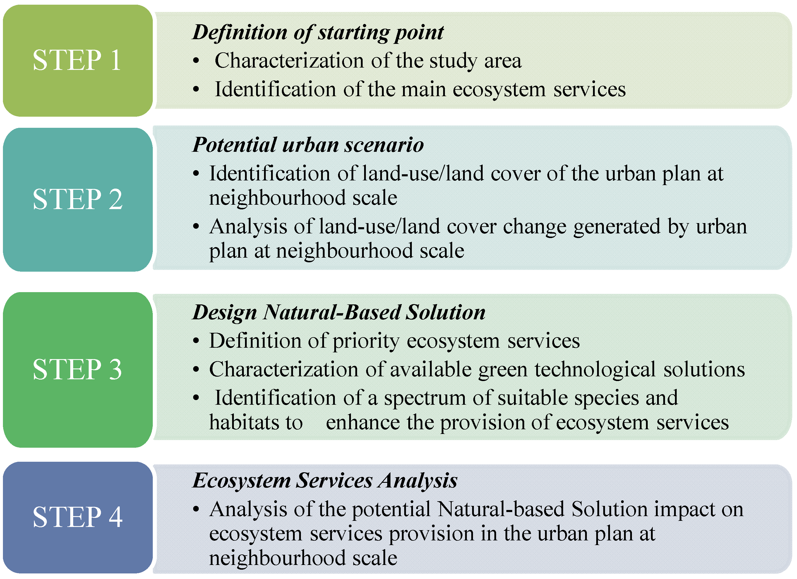
The methodology includes four phases (Figure 2). The first phase attempted to characterize the land use of the study area, while considering the infestation of Xylella fastidiosa—the driving force destroying the olive trees in the area.
The first phase of analysis revolved around the olive trees, involving an evaluation of disease severity, identification of cultural value, and identification of land uses, along with their ESs. Disease severity in the olive groves was estimated by visual inspection through evaluation of symptoms of X. fastidiosa related to leaf scorching and wilting of the canopy [3,37,38]. The cultural value of the monumental olive groves was analysed objectively by measuring diameter of the trunk and through a visual analysis of the shape of the plants’ trunk, as established by the regional law 14/2007 (B.U.R. PUGLIA—N. 83, 7 June 2007) [3,38,39]. Land use classes were characterized by considering the main bibliography and involving specific experts, along with their capacity to provide ecosystem services [16,38,40,41,42,43,44].
The second phase aimed to define the urban neighbourhood plan. Land use/land cover change analysis was performed in comparison with the initial status of the land use/land cover of the study area. Vectorial overlaps of different land use/land cover scenarios using QGIS software was applied for the analysis of land use/land cover. The analysis highlighted and quantified the typologies of spatial transformations promoted by the urban plan [3,45].
The third phase of analysis attempted to evaluate the main ecosystem services that were important for human well-being in the urban context, and attempted to identify potential NbSs to adopt for urban planning. This phase was carried out coherently with the developed urban neighbourhood plan, and the landscape and environmental conditions of the study area [46]. Moreover, the perceptions shared by the experts involved in the planning activities and the bibliography were important to define the relations between the NbSs and the priority ESs.
In the end, the main effect of the NbSs on the provisioning of ESs was analysed. The quantification of CO2 sequestration was made for four scenarios, as the starting point scenarios with healthy olive trees (past scenario), the starting point scenario with dry olive trees (scenario 0), the urban plan scenario (scenario 1), and the scenario that integrates the NbSs in the urban plan (scenario 2). CO2 sequestration was chosen as indicator of ESs, linked with the air quality conditions and climate regulation that have environmental impacts in urban development [47,48,49,50,51,52,53,54,55]. The CO2 sequestration was estimated considering the main ecological and biophysical functions generated by the land use of each scenario and using the literature-defined values [56].
Moreover, in this phase, the variation of the cultural value of the land use change was also analysed qualitatively by considering the conversion of the olive groves due to Xylella fastidiosa, and proposed NbSs through considering the context of the study area, the expert involved, and the bibliography.

3. Results

3.1. Land Use Characterization of Different Scenarios

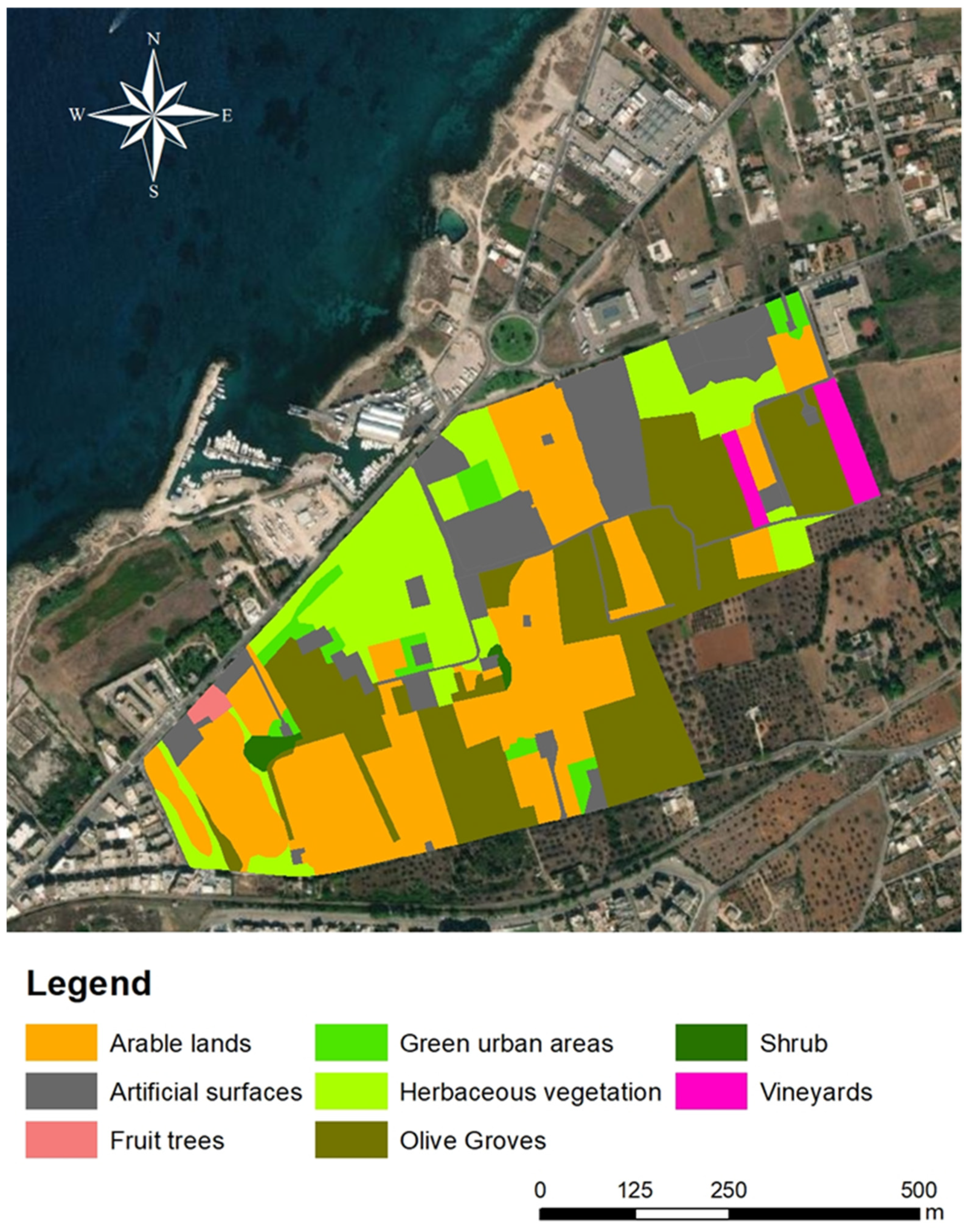
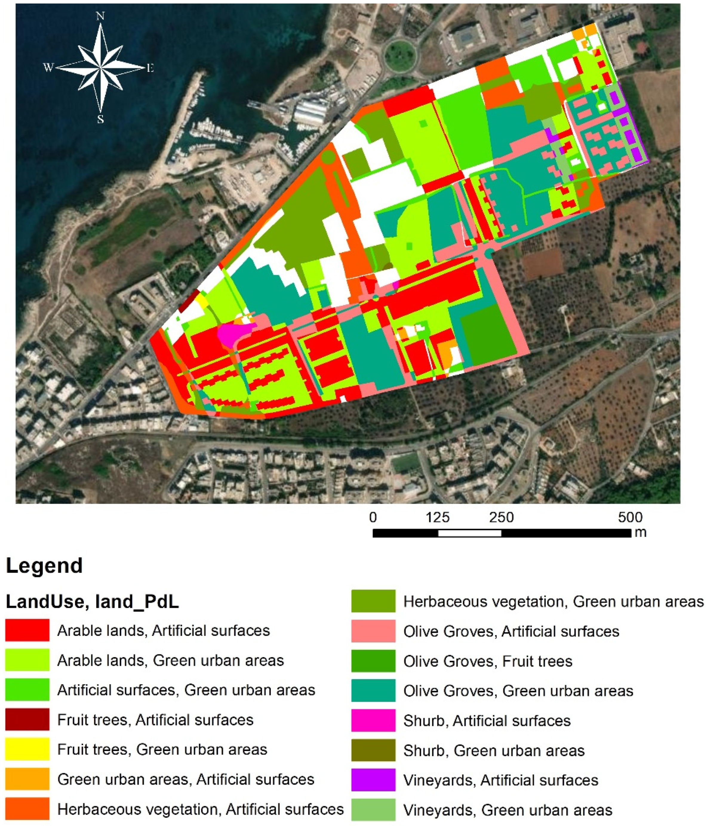
The land use of the area (Figure 1) was mainly characterized by “Arable land” (33% of the total surface) and “Olive grove” (28% of the total surface) (Table 1 and Figure 3).
There were artificial surfaces (roads and buildings) that covered 16% of the study area. The presence of natural vegetation was very low (shrub with 0.3 ha) and characterized 1% of the total area. The herbaceous vegetation was nitrous, comprising ruderal flora with a low ecological value, and was conditioned by present and past anthropogenic activities. Though 63% of the area was characterized by agricultural use, this use was scarce and poorly productive. The arable land was characterized by strong fragmentation by the owners and, in many cases, was represented by small plots used as vegetable gardens.
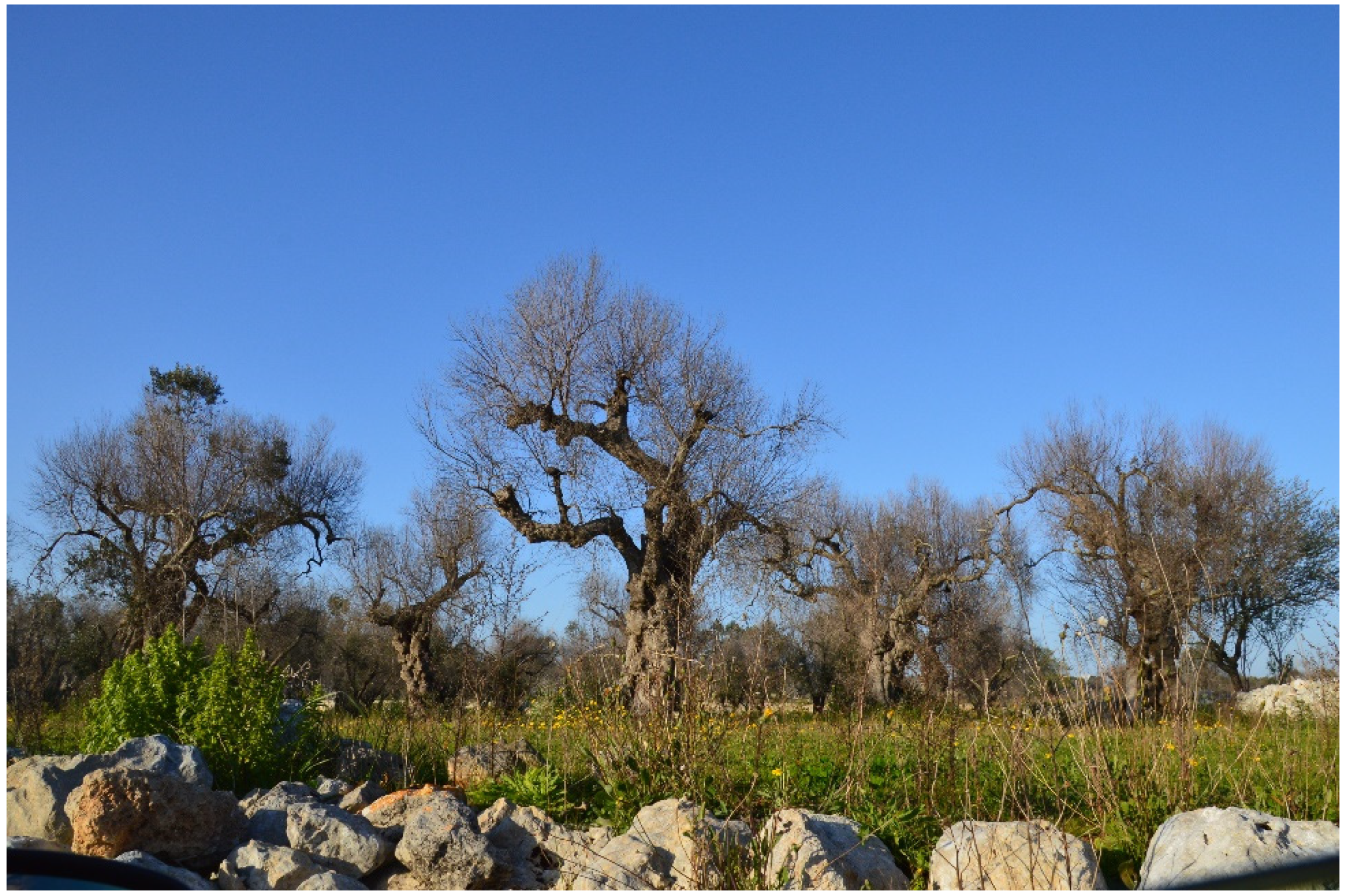
The main ecosystem services were provided by the olive groves (Table 2). The olive groves land use was characterized by the presence of many olive trees with cultural value, as defined by regional law (LR 14/2007, B.U.R. PUGLIA—N. 83, 7 June 2007). Out of 350 olive trees analysed, 200 had a monumental character, 66 of which had a diameter larger than 70–100 cm, with a sculptural shape, representing important cultural and aesthetic value in the landscape. However, the area of the olive groves was severely infected by X. fastidiosa, and almost all the trees have a canopy with desiccated branches. Due to the heavy infestation of the now desiccated olive groves, these plants were considered dead. The presence of X. fastidiosa had a strong ecological impact; therefore, the olive groves have lost their ecological function in the landscape (Figure 4).
The removal of the infected monumental olive trees would cause the loss of an identity element of the landscape of Gallipoli, which would never be restored. In addition, the olive grove was an important carbon sink and therefore had an important role in mitigating the local microclimate and the improved air quality of the local area. Paradoxically, the olive trees that were previously a valuable element of the landscape now represent an element of degradation in the landscape (Table 2).
The olive groves were characterized by nitrophilous ruderal vegetations, which had low interest from the landowner, due to the loss of productivity. Earlier, the main ecosystem services produced from these groves was raw material, derived by the utilization of the wood.
Hence, the provision of ecosystem services of the olive trees affected by X. fastidiosa was almost comparable to uncultivated areas characterized by herbaceous ruderal vegetation [42].
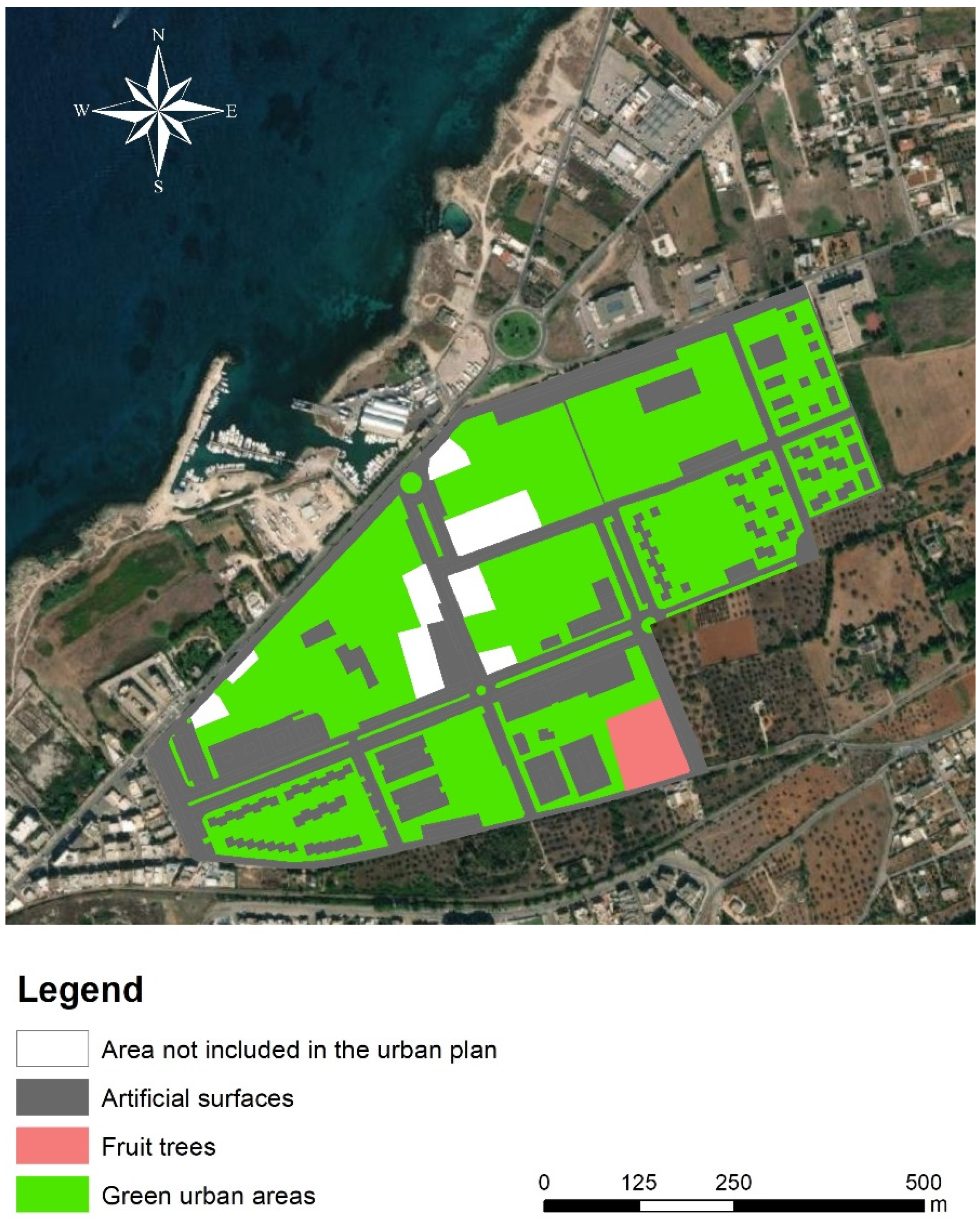
The urban neighbourhood plan was developed, reducing the potential artificial surface planned in the municipal urban plan of Gallipoli. The total artificial surface planned was about 15 ha of the area, corresponding to 38% of the total area, about double the original artificial surface during the starting scenario (Table 3 and Figure 5).
The increase in the artificial surface at later phases was mainly from the arable land (5.9 ha), in the olive groves, 3.2 ha, and in the herbaceous vegetation, 2.7 ha (Table 4). The arable land was mainly developed in the form of the new building and connected areas, whereas the olive groves were used for the realization of new roads (Figure 6). So, accounting of ES lost due to the new building in arable land was limited. However, considering the health status of olive groves, the ecosystem services which were lost due to their conversion to artificial surfaces were also minimal, and comparable to the ecosystem services lost from the conversion of herbaceous vegetation into building areas.
The urban neighbourhood plan could produce an increase in ecosystem services from the conversion of the “arable lands” and “herbaceous vegetation” in “urban green areas”. The important aspect, in this case, was the way of the ecological design of the green area that has to be realized in an active manner to develop important ecological functions for human well-being.

3.2. Proposed Nature-Based Solutions

As the urban plan was developed at a local scale, it is possible to prioritize the ESs that can be developed considering the specific environmental issues that characterize the urban area, such as the quality of the air and microclimate, that can be altered due to the built environmental and human activities.
Regulating services, defined as “air quality regulation” and “climate regulations”, were classified as prioritized ESs, and can be planned in the area for mitigative purposes [59,60]. In the area occupied by dead olive groves, the mitigation actions of the urban neighbourhood plan have to focus various opportunities—recovering aesthetic information; building opportunities for recreation and tourism; inspiration for culture, art, and design; spiritual experience (P); information for cognitive development (P)—provided by the monumental olive trees (Table 5) [38,42]. This is important for restoring the original cultural value of the area where many monumental olive trees were located, which are now dry/dead due to Xylella fastidiosa. So, while developing the urban plan, the cultural and amenity services can be considered as priority ecosystem services.
Of course, the definitions of priority ecosystem services do not exclude the possibility of introducing other ecosystem services. The design of priority ecosystem services can also support to the development of various indirect ecosystem services producing other co-benefits. For instance, the locations, dimensions, and typologies of the public spaces might not be suitable for obtaining new habitats with income generation for the local population; however, they can develop the social activities linked with food production, raw materials, medicinal resources, and ornamental resources, i.e., these ecosystem services can be considered and classified as co-benefits.
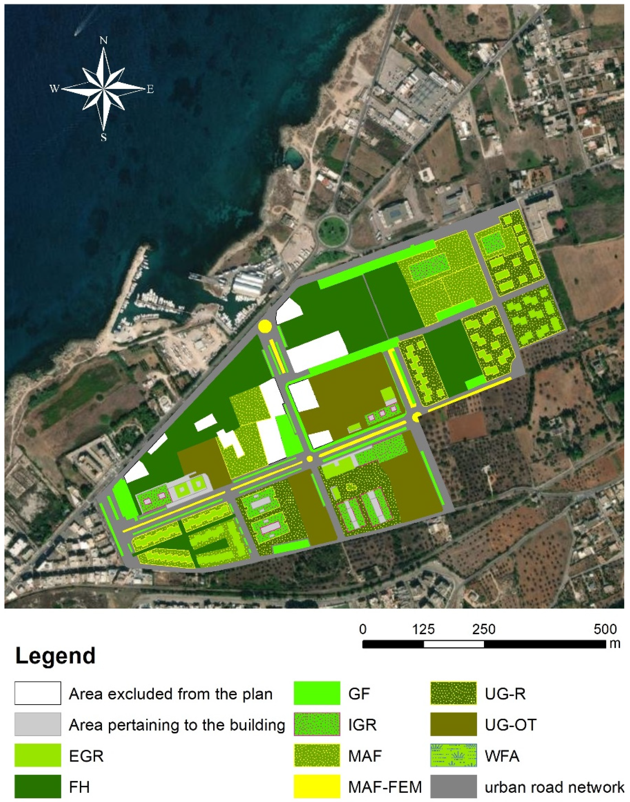
This phase was developed by considering the NbSs that can be developed in the urban areas to support ecosystem services. The main solutions are highlighted in Table 5 and Figure 7.
Mainly, the solutions reported in the literature have been adopted [20,40,52,53,54,55,56,57,58,59] for the study area.
These infrastructures cannot represent a large natural area; however, they can improve specific ecological functions, increase human health, and enhance local biodiversity. In an urban context, where ecological land use is in competition with social and economic land use, it is necessary to implement whatever measures are possible, independently of the dimensions.
The NbSs are proposed by considering the priority ecosystem services in relation with land use and land cover in the urban plan at the neighbourhood scale, the experiences of the experts involved in urban processes, and bibliography research.
In this study area, it was decided to assign equal importance to cultural value and the regulation services—“air quality regulation” and “climate regulations” [84]. Therefore, the application of the fruit crops and the replacement of dead olive trees is seen as fundamental. Other priorities could produce different solutions. For example, by giving more importance to CO2 sequestrations, it is possible to set up the green area with species with high carbon sequestration potential, independently of fruit production, or to reduce the extension of the community gardens to allow for forest areas.

3.3. Ecosystem Services Impact Assessment

The study area is a private urban area; therefore, the land cover and land use transformations are conditioned by both public and private choices. The urban land use is conditioned by the municipal urban plan of Gallipoli city, which defines this area as a residential urban sprawl zone of the city. However, the urban land cover transformations are defined by the choices of private landowners, by planning urban structures, such as buildings, parking areas, urban gardens, etc., in order to obtain their own economic profit. Therefore, in this phase, the future urban development of the neighbourhood is linked to local private initiatives and economic investment, and not to public actions and funding. In this way, it is important to highlight the potential ecosystem services provided by the land cover land use generated by new urban development plans at a neighbourhood scale. The bottom–up actions for NbSs require practical application of the international policies, and require sustainability to be addressed.
In the study area, the transition from “Past Scenario” (pre-X. fastidiosa) to “Scenario 0” (post-X. fastidiosa) produces a loss of ecosystem services, such as “Air quality regulation” and “Climate regulation”, due to the loss of the thick crown of the dead olive trees (Figure 3; Table 5). This situation persisted from 2017, and has produced a loss of 74% of the capacity to absorb CO2 in this area (Table 6).
The important losses of ESs were the following: “Aesthetic information”; “Opportunities for recreation and tourism”; “Inspiration for culture”, “Art and design”; “Spiritual experience”; “Information for cognitive development”. These can be considered irreversible transformations. In addition, the presence of dry olive trees and of uncultivated trees can give the vision of a degraded and abandoned landscape, where the improvisation of the individual persists, without a vision of uniform urban development.
Passing from “Scenario 0” to “Scenario 1”, the land use capacity of the “Air quality regulation” and the capacity to absorb CO2 may not be different. However, the increase in the impermeable surface is likely compensated by the increase in the urban green areas.
The development of NbSs (Scenario 2) may cover the capacity to absorb CO2 of the scenario pre-X. fastidiosa. The dead olive trees will be replaced with new trees, promoting biophysical structure, able to support pollution absorbance as CO2. Therefore, compared with “Scenario 0”, the NbSs could quadruple the capacity to absorb CO2 due to the general expansion of wooded surfaces with the replacement of the dead olive trees and the conversion of arable lands in urban community gardens characterized by tree fruits. Therefore, the transition from “Scenario 1” to “Scenario 2” is favourable and should be sponsored (Table 6).
Moreover, the NbS can reduce the emission of CO2. For example, the green roofs can increase energy-saving capacity in the buildings by reducing the greenhouse gases emissions, with positive effect on carbon footprints [7]. Therefore, the bottom–up action of the private stakeholders at the neighbourhood scale has a key role in their following sustainable policies, as promoted by the international initiative—“Climate Neutral and Smart Cities”—where cities are committed to a new form of sustainable urban transformation towards climate neutrality by 2030 [85].
NbSs measures increase the permeable surface of the area due to the realization of green roofs. This can improve ecosystem services, such as “Climate regulation”, “Moderation of extreme events”, and “Regulation of water flows”. The presence of forest habitats and creation of microhabitats are able to support local insects and animals, and also the biodiversity of the area. These areas were designed to try to create a continuous habitat between private green urban areas and public green urban areas.
The NbSs provide the use of endemic vegetations with germplasms derived from the local context, with particular attention to the melliferous and aromatic flora essences. Therefore, this can reduce the water input and management actions for the vegetation, by reducing the use of natural resources [82].
The urban community gardens can improve the cultural aspect of the area linked to the agricultural landscape. Of course, these cannot introduce the same cultural aspect as the monumental olive groves, but they can contribute to cultural functionality of the area. Moreover, using agricultural melliferous, aromatic flora could be important to increase pollination functions.
The community gardens are important nature-based solutions planned in the urban plan, sponsored by smart city strategies, promoted by Horizon 2020, to foster social aspects, such as psychological well-being, and reinforce the sense of community, if compared with the actual status. The community gardens have great potential to build personal relationships and social cohesion; therefore, they represent an important meeting place to create a sense of community in new urban areas [7,67]. In fact, in a social–ecological system, along with the presence of the cultural elements, the accessibility and possibility for the stakeholders to use them is also important [46,86]. The foreseen NbSs strive to implement the fruition in the area, maintaining the cultural agricultural value. Additionally, in this case, the choice of agricultural vegetation for implementing social and educational values is important.
The NbSs can be linked to the concept of serendipity and hence the possibility of such interventions to obtain benefits that was unforeseen in the initial design goal, without the need of quantifying or evaluating them [38]. Thus, the development of community gardens could be followed by extreme and experimental actions to preserve the historical value linked to the presence of monumental olive trees as much as possible. For example, there is possibility for the development of artistic elements or street furniture, starting from the use of olive tree trunks along the dry-stone wall in the area, or in a small portion of the area pertaining to the plan.
The olive trees affected by Xylella fastidiosa that have not been eradicated could be experimentally preserved in place (avoiding their eradication) in order to transform them into artistic works of furniture for the community gardens that will be built. An art competition could be organized in order to encourage participation from more artists and to have a greater number of proposed solutions, along with increased creativity of the solutions.
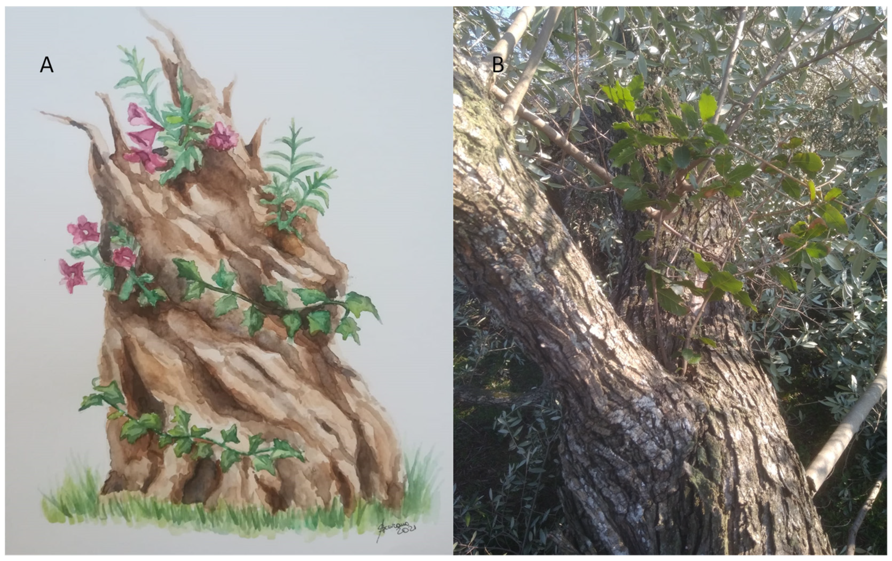
The trunks of the non-eradicated olive trees can be used as support for the development of ornamental plants and can be covered with climbing plants (Figure 8A—artistic drawing as an example of what can be achieved). In this case, the chosen olive tree would not be eradicated, but rather left to provide support for the development of ornamental plants. Alternatively, other plants can be allowed to grow on the olive tree trunk, as shown in the example in Figure 8B (oak plant spontaneously developing its roots within the dry trunk). After all, if nature does not act by chance, but according to the logic dictated by the opportunities that arise, we can stimulate and create these opportunities.

4. Discussion

The development of NbSs in the urban neighbourhood plan should contribute to reducing the negative effects of urban land use and land cover transformation from conversion of part of the arable land into building elements and road networks. The ecosystem services analysis provides indications on how NbSs can have positive effects in urban sprawl in terms of typologies and level of ecological functions developed between different land use and land cover options. In this case, both the amount of green space and the typologies of the greens spaces and the vegetation used are important factors. This is the main difference between scenario 1 and scenario 2 (Table 6).
In the case of Gallipoli, the diffusion of the Xylella fastidiosa has produced an irreversible loss of cultural ecosystem services and provision of ecosystem services (production of olive oil), mainly connected with the monumental olive groves that cannot be recovered in the short time. In the current state, the low value of the area for agricultural production, and the land owners’ interest in urban transformation in agreement with the municipal urban plan, can push them not to apply any actions for vegetation recovery, which might have negative effects on the ecosystem services and landscape value. This is mainly appliable to socioecological systems, where the interest in human well-being is high, and changes in land use and ecosystem services can be caused by human choices that may prefer to abandon the land instead of using it [36]. Every action is important to shape the landscape, and simple abandonment due to the scarce economic interest presented by the landscape can produce negative effects.
The urban planning at the neighbourhood scale can have a role in aggregating all stakeholders by developing a unique vision of landscape development. Instead, in the current state, the individual owners (with an average of 0.5 ha each) could develop heterogeneous actions leading to a worsening of the situation, or even decide to do not act, due to the low economic interest in the investment of money.
Therefore, in the peri-urban area, characterized by landscape degradation and urban development, the urban development plan could represent an opportunity to increase the resilience of the landscape. The urban neighbourhood plan can develop the interest and economic support of the companies to apply landscape transformation. The ecosystem services analysis in the urban planning process can be useful to increase the social and ecological resilience of some ecosystem services, such as CO2 sequestrations of the area recovering important ecological functions, and structure lost for X. fastidiosa spread.
The strategies of NbSs represent new ecological elements that could reduce the impact of the urban land use change and the increases in the priority ecosystem services to achieve the environmental objectives of the urban plan at a neighbourhood scale. This approach could be applied at municipal and regional scales to determine the provision of ecosystem services by the land use/land cover, where the NbSs become specific patches of the land use/land cover pattern. However, at municipal and regional scales, the priorities of ecosystem services could change, and other factors have to be considered and analysed, such as creating and analysing an ecological network between the nature-based solutions and natural areas. In this way, the introduction of NbS and ecosystem services analysis should be developed in terms of green infrastructure, defined as a “strategically planned network of natural and semi-natural areas with other environmental features designed and managed to deliver a wide range of ecosystem services…” [27,28,87].
However, the analysis of ecosystem services is not a substitute for evaluations of the effects caused by waste production, mobility, quality of the area, and use of water resources, etc. An ES approach should be considered as a tool to better arrange the relationships between biodiversity, ecological functions, and urban land use/land cover. Therefore, the analysis of ecosystem services in the urban planning process should be considered complementary to other approaches and not preponderant or exclusive. For example, in this case, the analysis of ecosystem services should be weighed with other social and economic factors, such as the need of houses, especially in communities with economically deprived populations.
The impacts of NbSs on ecosystem services provision in the new urban area can be tested when the urban plan is realized. Therefore, the present study represents a prevision analysis, derived considering objective data by a bibliography analysis and studies already tested, expert contributions, and the landscape context. Moreover, the use of ecosystem services within the urban neighbourhood plan can be considered as an additional tool to bring designers closer to ecological and social issues for local planning. Above all, it helps to perceive the actions aimed at sustainability as important for obtaining a higher quality and more attractive plan, without any additional costs for planners.
Another important element is the temporal projection of the mitigation strategies that are developed. In this study, “the cultural amenity services” have been considered priority ecosystem services for the past characteristics of the study areas, where beautiful monumental olive trees were present, now destroyed by the Xylella fastidiosa. The cultural value regeneration was focused on both new agricultural practices in respect to the past scenarios to introduce new fruit plants, or the reestablishment of old olive groves using species resistant to Xylella fastidiosa. Indeed, the sustainable concept of ecosystem services analysis is focused on future generations; therefore, it is intrinsic that the cultural strategies should promote the transformation developed from the urban plan considering long-term visions. Therefore, the cultural strategies should be developed not only considering how the area is in the present, but how this area would be in the future. Only in this way we can realize the future cultural landscape, as well as acknowledging the contributions of past generations. Therefore, in this study, we might obtain a landscape structure that can partially recover the cultural value of the olive trees, considering the adopted mitigation actions over a long period. For example, by proposing again the techniques used in the past to grow olive groves in the community gardens, in about 50–100 years we can produce olive trees with huge trunk diameters and heights. Indeed, the monumental olive trees shapes are the result of past human agricultural practices that, in current economic productions, are not feasible [3,38,43]. So, if we want to repropose the cultural structure of olive groves, then it is necessary to repropose the past cultural systems of production in synergy with the olive tree plants. This is a hard application, but it is not impossible in the community garden, where social activity and maintenance of cultural values are priorities in respect to agricultural economic productions.

5. Conclusions

In this paper, we focused on the application of an ecosystem services analysis in urban planning at a neighbourhood scale. This methodology represents a cultural leap in the use of the concept of ecosystem services in urban planning at a neighbourhood scale. It combines an assessment and mapping of the actions of ES, with the ability to plan and design them using NbSs, which are too often developed in isolation.
The approach applied emphasis on the capacity to design mitigation measures with NbSs to improve ecosystem services, which are useful in satisfying environmental goals and human well-being. In this case, the analysis of ecosystem services in the urban neighbourhood plan does not represent an integrative study developed separately in the context of urban planning process, but rather it represents an element that merges with the urban planning development to produce a new vision related to the sustainability of urban planning.
In this study, we develop an overview of how the concept of ecosystem services can be integrated into the workflow of the urban planning process, concerning the positive effect of the integration of vegetation into the urban infrastructure, with the possibility of developing specific NbSs. However, in the specific urban contexts and plan, it is necessary to consider the potential ecosystem disservices that the vegetation can produce, such as the absorbance of heavy metals in the fruit or the allergenic matters of production [61]. For example, the green roof and the urban community gardens may have negative ecological effects or create ecosystem disservices. Nitrogen, phosphorus, and potassium, for example, may accumulate in high concentrations in garden soils [88] due to the indiscriminate application of fertilizers or compost, polluting urban stormwater runoff or groundwater [89]. Therefore, the consideration of the ecosystem services concept in the urban planning process needs a transdisciplinary approach to account for all the potential effects on the relationships and interactions that can be developed between the urban ecosystem and human benefits. Mainly, in the urban context, where different social and economic interests coexist, stakeholder consultation is crucial to obtain existing information and to confirm the values, interests, and dependencies on priority ecosystem services with the people who need and use them.

Author Contributions

Conceptualization, T.S.; methodology, T.S.; software, T.S.; validation, T.S., formal analysis, T.S.; investigation, T.S.; resources, T.S.; data curation, T.S.; writing—original draft preparation, T.S.; writing—review and editing, T.S., A.S. and R.P.; visualization, A.S.; supervision, T.S., A.S. and R.P.; All authors have read and agreed to the published version of the manuscript.

Funding

This research received no external funding.

Institutional Review Board Statement

Not applicable.

Informed Consent Statement

Not applicable.

Data Availability Statement

SIT Puglia: http://www.sit.puglia.it/ (accessed on 1 December 2021).

Acknowledgments

We thank Pietro Medagli, Alessio Turco, and Stefano Arzeni for supporting us in the development of strategic environmental assessment of the urban neighbourhood plan.

Conflicts of Interest

The authors declare no conflict of interest.

References

  1. Nuissl, H.; Haase, D.; Lanendorf, M.; Wittemer, H. Environmental impact assessment of urban land use transitions—A context-sensitive approach. Land Use Policy 2009, 26, 414–424. [Google Scholar] [CrossRef]
  2. Ahern, J.; Ciliers, S.; Niemela, L. The concept of ecosystem services in adaptive urban planning and design: A framework for supporting innovation. Landsc. Urban Plan. 2014, 125, 254–259. [Google Scholar] [CrossRef] [Green Version]
  3. Maggiore, G.; Semeraro, T.; Aretano, R.; De Bellis, L.; Luvisi, A. GIS Analysis of Land-Use Change in Threatened Landscapes by Xylella fastidiosa. Sustainability 2019, 11, 253. [Google Scholar] [CrossRef] [Green Version]
  4. Luck, M.; Wu, J. A gradient analysis of urban landscape pattern: A case study from the Phoenix metropolitan region, Arizona, USA. Landsc. Ecol. 2002, 17, 327–339. [Google Scholar] [CrossRef]
  5. Zhou, Y.; Chen, M.; Tang, Z.; Mei, Z. Urbanization, land use change, and carbon emissions: Quantitative assessments for city-level carbon emissions in Beijing-Tianjin-Hebei region. Sustain. Cities Soc. 2021, 66, 102701. [Google Scholar] [CrossRef]
  6. De Groot, R.S.; Alkemade, R.; Braat, L.; Hein, L.; Willemen, L. Challenges in integrating the concept of ecosystem services and values in landscape planning, management and decision making. Ecol. Complex. 2010, 7, 260–272. [Google Scholar] [CrossRef]
  7. Semeraro, T.; Scarano, A.; Buccolieri, R.; Santino, A.; Aarrevaara, E. Planning of Urban Green Spaces: An Ecological Perspective on Human Benefits. Land 2021, 10, 105. [Google Scholar] [CrossRef]
  8. La Rosa, D.; Spyra, M.; Inostroza, L. Indicators of Cultural Ecosystem Services for urban planning: A review. Ecol. Indic. 2016, 61, 74–89. [Google Scholar] [CrossRef]
  9. Baker, J.; Sheate, W.R.; Philips, P.; Eals, R. Ecosystem services in environmental assessment—Help or hindrance? Environ. Impact Assess. Rev. 2013, 40, 3–13. [Google Scholar] [CrossRef]
  10. United Nations. Resolution adopted by the General Assembly on 25 September 2015. In Proceedings of the Transforming our world: The 2030 Agenda for Sustainable Development (A/RSE/70/L.1), New York, NY, USA, 25–27 September 2015. [Google Scholar]
  11. OECD (Organisation for Economic Cooperation and Development). Strategic Environmental in Assessment Ecosystem Services. 2010. Available online: http://www.oecd.org/dataoecd/24/54/41882953.pdf (accessed on 28 December 2021).
  12. TEEB—The Economics of Ecosystems and Biodiversity. In TEEB Manual for Cities: Ecosystem Services in Urban Management; TEEB: Geneva, Switzerland, 2011.
  13. Larondelle, N.; Haase, D. Urban ecosystem services assessment along a rural–urban gradient: A cross-analysis of European cities. Ecol. Indic. 2013, 29, 179–190. [Google Scholar] [CrossRef]
  14. Partidario, M.R.; Gomes, R. Ecosystem Services Inclusive strategic Environmental Assessment. Environ. Impact Assess. Rev. 2013, 40, 36–46. [Google Scholar] [CrossRef]
  15. Geneletti, D. Chapter 3: Ecosystem services analysis for Strategic Environmental Assessment: Concepts and examples. In Research Handbooks on Impact Assessment Series; Geneletti, D., Ed.; Edward Elgar Publishing: Cheltenham, UK, 2016; pp. 41–61. ISBN 9781783478989. [Google Scholar] [CrossRef]
  16. Semeraro, T.; Radicchio, B.; Medagli, P.; Arzeni, S.; Turco, A.; Geneletti, D. Integration of Ecosystem Services in Strategic Environmental Assessment of a Peri-Urban Development Plan. Sustainability 2021, 13, 122. [Google Scholar] [CrossRef]
  17. Petrosillo, I.; Semeraro, T.; Zurlini, G. Detecting the ‘conservation effect’ on the maintenance of natural capital flow in different natural parks. Ecol. Econ. 2010, 69, 1115–1123. [Google Scholar] [CrossRef]
  18. Petrosillo, I.; Zaccarelli, N.; Semeraro, T.; Zurlini, G. The effectiveness of different conservation policies on the security of natural capital. Landsc. Urban Plan. 2009, 89, 49–56. [Google Scholar] [CrossRef]
  19. Connecting Nature. Available online: https://connectingnature.eu/about (accessed on 30 January 2022).
  20. Mell, I.C. Can green infrastructure promote urban sustainability? Proc. Inst. Civ. Eng.: Eng. Sustain. 2009, 162, 23–34. [Google Scholar] [CrossRef]
  21. Taylor-Lovell, S.; Taylor, J.R. Supplying urban ecosystem services through multifunctional green infrastructure in the United States. Landsc. Ecol. 2013, 28, 1447–1463. [Google Scholar] [CrossRef]
  22. Anguluri, R.; Narayanan, P. Role of green space in urban planning: Outlook towards smart cities. Urban For. Urban Green. 2017, 25, 58–65. [Google Scholar] [CrossRef]
  23. Keesstra, S.; Nunes, L.; Novara, A.; Finger, D.; Avelar, D.; Kalantari, Z.; Cerdà, A. The superior effect of nature based solutions in land management for enhancing ecosystem services. Sci. Total Environ. 2018, 610–611, 997–1009. [Google Scholar] [CrossRef] [Green Version]
  24. Jo, H.K. Impacts of urban greenspace on offsetting carbon emissions for middle Korea. J. Environ. Manag. 2002, 64, 115–126. [Google Scholar] [CrossRef]
  25. Majekodunmi, M.; Emmanuel, R.; Jafry, T. A spatial exploration of deprivation and green infrastructure ecosystem services within Glasgow city. Urban For. Urban Green. 2020, 52, 126698. [Google Scholar] [CrossRef]
  26. Song, P.; Kim, G.; Mayer, A.; He, R.; Tian, G. Assessing the Ecosystem Services of Various Types of Urban Green Spaces Based on i-Tree Eco. Sustainability 2020, 12, 1630. [Google Scholar] [CrossRef] [Green Version]
  27. Semeraro, T.; Aretano, R.; Pomes, A.; Del Giudice, C.; Nigro, D. Planning ground based utility scale solar energy as Green Infrastructure to enhance ecosystem services. Energy Policy 2018, 117, 218–227. [Google Scholar] [CrossRef]
  28. Semeraro, T.; Aretano, R.; Barca, A.; Pomes, A.; Del Giudice, C.; Gatto, E.; Lenucci, M.; Buccolieri, R.; Emmanuel, R.; Gao, Z.; et al. A Conceptual Framework to Design Green Infrastructure: Ecosystem Services as an Opportunity for Creating Shared Value in Ground Photovoltaic Systems. Land 2020, 9, 238. [Google Scholar] [CrossRef]
  29. Turner, B.L.; Skole, D.; Sanderson, S.; Fischer, G.; Fresco, L.; Leemans, R. Land-use and Land-cover Change Science/Research Plan. In Joint Publication of the International Geosphere-Biosphere Programme (Report No. 35) and the Human Dimensions of Global Environmental Change Programme (Report No. 7); Royal Swedish Academy of Sciences: Stockholm, Sweden, 1995. [Google Scholar]
  30. Brown, D.G.; Pijanowski, B.C.; Duh, J.D. Modeling the relationships between land-use and land-cover on private lands in the Upper Midwest, USA. J. Environ. Manag. 2000, 59, 247–263. [Google Scholar] [CrossRef] [Green Version]
  31. Sevianu, E.; Maloş, C.V.; Arghiuş, V.; Brişan, N.; Bǎdǎrǎu, A.S.; Moga, M.C.; Muntean, L.; Rǎulea, A.; Hartel, T. Mainstreaming Ecosystem Services and Biodiversity in Peri-Urban Forest Park Creation: Experience From Eastern Europe. Front. Environ. Sci. 2021, 9, 618217. [Google Scholar] [CrossRef]
  32. Richards, D.; Fung, T.K.; Meili, N.; Song, X.P.; Dissegna, A.; Drillet, Z.; Urech, P.; Edward, P. An Ecosystem Service Design Loop for Using Vegetation to Mitigate the Urban Heat Island Effect. In Future Cities Lab Indicia 2; Cairns, S., Tunas, D., Eds.; Lars Müller Publishers: Zurich, Switzerland, 2019. [Google Scholar]
  33. Trenberth, K.E.; Jones, P.D.; Ambenje, P.; Bojariu, R.; Easterling, D.; Tank, A.K.; Parker, D.; Rahimzadeh, F.; Renwick, J.A.; Rusticucci, M.; et al. Observations: Surface and atmospheric climate change. In Climate Change 2007: The Physical Science Basis. Contribution of Working Group I to the Fourth Assessment Report of the Intergovernmental Panel on Climate Change; Solomon, S., Qin, D., Manning, M., Chen, Z., Marquis, M., Averyt, K.B., Tignor, M., Miller, H.L., Eds.; Cambridge University Press: Cambridge, UK, 2007. [Google Scholar]
  34. Leemans, R. Modelling of Global Land Use: Connections, Causal Chains and Integration Inaugural Lecture; Wageningen University: Wageningen, The Netherlands, 2000; p. 85. [Google Scholar]
  35. Piracha, A.L.; Marcotullio, P.J. Urban Ecosystem Analysis Identifying Tools and Methods; United Nations University Institute of Advanced Studies: Tokyo, Japan, 2003. [Google Scholar]
  36. Semeraro, T.; Zaccarelli, N.; Lara, A.; Sergi-Cucinelli, F.; Aretano, R. A Bottom-Up and Top-Down Participatory Approach to Planning and Designing Local Urban Development: Evidence from an Urban University Center. Land 2020, 9, 98. [Google Scholar] [CrossRef] [Green Version]
  37. Luvisi, A.; Nicolì, F.; De Bellis, L. Sustainable Management of Plant Quarantine Pests: The Case of Olive Quick Decline Syndrome. Sustainability 2017, 9, 659. [Google Scholar] [CrossRef] [Green Version]
  38. Semeraro, T.; Gatto, E.; Buccolieri, R.; Catanzaro, V.; De Bellis, L.; Cotrozzi, L.; Lorenzini, G.; Vergine, M.; Luvisi, A. How Ecosystem Services Can Strengthen the Regeneration Policies for Monumental Olive Groves Destroyed by Xylella fastidiosa Bacterium in a Peri-Urban Area. Sustainability 2021, 13, 8778. [Google Scholar] [CrossRef]
  39. Apulian Law. Protection and Enhancement of the Landscape of the Monumental Olive Trees of Apulia. Official Bulletin of the Apulian Region—n. 83 Suppl. of 7-6-2007. 2007. Available online: http://www.geologipuglia.it/doc/downloads/457-lr_4_06_2 (accessed on 27 December 2021).
  40. United Nations Environment Programme. Integrating Ecosystem Services in Strategic Environmental Assessment: A Guide for Practitioners; ISO 14001:2004 Certified; UNON, Publishing Services Section: Nairobi, Kenya, 2014; Available online: http://www.ing.unitn.it/~genelab/documents/GuidelineESintoSEA.pdf (accessed on 13 December 2021).
  41. Burkhard, B.; Crossman, N.; Nedkov, S.; Petz, K.; Alkemade, R. Mapping and Modelling Ecosystem Services for Science, Policy and Practice. Ecosyst. Serv. 2013, 4, 1–3. [Google Scholar] [CrossRef]
  42. Semeraro, T.; Gatto, E.; Buccolieri, R.; Vergine, M.; Gao, Z.; De Bellis, L.; Luvisi, A. Changes in Olive Urban Forests Infected by Xylella fastidiosa: Impact on Microclimate and Social Health in urban areas. Int. J. Environ. Res. Public Health 2019, 16, 2642. [Google Scholar] [CrossRef] [Green Version]
  43. Semeraro, T.; Buccolieri, R.; Vergine, M.; De Bellis, L.; Luvisi, A.; Emmanuel, R.; Marwan, N. Analysis of Olive Grove Destruction by Xylella fastidiosa Bacterium on the Land Surface Temperature in Salento Detected Using Satellite Images. Forests 2021, 12, 1266. [Google Scholar] [CrossRef]
  44. Mentese, E.Y.; Tezer, A. Impacts of Infrastructure Developments on Ecosystem Services Potential in Istanbul. Front. Environ. Sci. 2021, 9, 614752. [Google Scholar] [CrossRef]
  45. Aretano, R.; Petrosillo, I.; Zaccarelli, N.; Semeraro, T.; Zurlini, G. People perception of landscape change effects on ecosystem services in small Mediterranean islands: A combination of subjective and objective assessments. Landsc. Urban Plan. 2013, 112, 63–73. [Google Scholar] [CrossRef]
  46. Semeraro, T.; Aretano, R.; Pomes, A. Green infrastructure to improve ecosystem services in the landscape urban regeneration. IOP Conf. Ser.: Mater. Sci. Eng. 2017, 245, 082044. [Google Scholar] [CrossRef]
  47. Kaspersen, P.S.; Høegh Ravn, N.; Arnbjerg-Nielsen, K.; Madsen, H.; Drews, M. Comparison of the impacts of urban development and climate change on exposing European cities to pluvial flooding. Hydrol. Earth Syst. Sci. 2017, 21, 4131–4147. [Google Scholar] [CrossRef] [Green Version]
  48. Walter, L.F.; Icaza, L.E.; Neht, A.; Klavins, M.; Morgan, E.A. Coping with the impacts of urban heat islands. A literature based study on understanding urban heat vulnerability and the need for resilience in cities in a global climate change context. J. Clean. Prod. 2018, 171, 1140–1149. [Google Scholar] [CrossRef] [Green Version]
  49. United Nations. World Urbanization Prospects: The 2014 Revision, Highlights. In Department of Economic and Social Affairs; Population Division, United Nations: New York, NY, USA, 2014. [Google Scholar]
  50. Harlan, S.L.; Ruddel, D. Climate change and health in cities: Impacts of heat and air pollution and potential co-benefits from mitigation and adaptation. Curr. Opin. Environ. Sustain. 2011, 3, 126–134. [Google Scholar] [CrossRef]
  51. Hirano, Y.; Yoshida, Y. Assessing the effects of CO2 reduction strategies on heat islands in urban areas. Sustain. Cities Soc. 2016, 26, 383–392. [Google Scholar] [CrossRef]
  52. Hsieh, C.M.; Huang, H.C. Mitigating urban heat islands: A method to identify potential wind corridor for cooling and ventilation. Comp. Environ. Urban Syst. 2016, 57, 130–143. [Google Scholar] [CrossRef]
  53. Qiu, G.-Y.; Li, H.-Y.; Zhang, Q.-T.; Chen, W.; Liang, X.-J.; Li, X.-Z. Effects of Evapotranspiration on Mitigation of Urban Temperature by Vegetation and Urban Agriculture. J. Integr. Agric. 2013, 12, 1307–1315. [Google Scholar] [CrossRef]
  54. Gartland, L. Heat Islands: Understanding and Mitigating Heat in Urban Areas; Routledge: London, UK, 2010. [Google Scholar]
  55. Emmanuel, R.; Krüger, E. Urban Heat Islands and its impact on climate change resilience in a shrinking city: The case of Glasgow, UK. Build. Environ. 2012, 53, 137–149. [Google Scholar] [CrossRef]
  56. De Marco, A.; Petrosillo, I.; Semeraro, T.; Pasimeni, M.R.; Aretano, R.; Zurlini, G. The contribution of Utility-Scale Solar Energy to the global climate regulation and its effects on local ecosystem services. Glob. Ecol. Conserv. 2014, 2, 324–337. [Google Scholar] [CrossRef] [Green Version]
  57. De Groot, R.S. Function-analysis and valuation as a tool to assess land use conflicts in planning for sustainable, multi-functional landscapes. Landsc. Urban Plan. 2006, 75, 175–186. [Google Scholar] [CrossRef]
  58. De Groot, R.S.; Wilson, M.; Boumans, R. A typology for the description, classification and valuation of Ecosystem Functions. Goods Serv. Econ. 2002, 41, 393–408. [Google Scholar]
  59. Fischer, L.K.; Honold, J.; Botzat, A.; Brinkmeyer, D.; Cvejic, E.; Delshammar, T.; Kowarik, I. Recreational ecosystem services in European cities: Sociocultural and geographical contexts matter for park use. Ecosyst. Serv. 2018, 31, 455–467. [Google Scholar] [CrossRef]
  60. Arnberger, A.; Eder, R. Are urban visitors’ general preferences for green-spaces similar to their preferences when seeking stress relief? Urban For. Urban Green. 2015, 14, 872–882. [Google Scholar] [CrossRef]
  61. von Döhren, P.; Haase, D. Ecosystem disservices research: A review of the state of the art with a focus on cities. Ecol. Indic. 2015, 52, 490–497. [Google Scholar] [CrossRef]
  62. Tan, B.A.; Gaw, L.Y.-F.; Masoudi, M.; Richards, D.R. Nature-Based Solutions for Urban Sustainability: An Ecosystem Services Assessment of Plans for Singapore’s First “Forest Town”. Front. Environ. Sci. 2021, 9, 610155. [Google Scholar] [CrossRef]
  63. United States General Services Administration. The Benefits and Challenges of Green Roofs on Public and Commercial Buildings. 2011. Available online: https://www.gsa.gov/about-us/organization/office-ofgovernmentwide-policy/office-of-federal-highperformance-buildings/projects-andresearch/green-roofs (accessed on 27 January 2021).
  64. U.S. National Climate Assessment. Global Change Research Program. 2014. Available online: https://nca2014.globalchange.gov/highlights/report-findings/water-supply (accessed on 27 October 2021).
  65. Pulighe, G.; Fava, F.; Lupia, F. Insights and opportunities from mapping ecosystem services of urban green spaces and potentials in planning. Ecosyst. Serv. 2016, 22, 1–10. [Google Scholar] [CrossRef]
  66. Wand, J.; Banzhaf, E. Towards a better understanding of Green Infrastructure: A critical review. Ecol. Indic. 2018, 85, 758–772. [Google Scholar] [CrossRef]
  67. Scarano, A.; Semeraro, T.; Chieppa, M.; Santino, A. Neglected and Underutilized Plant Species (NUS) from the Apulia Region Worthy of Being Rescued and Re-Included in Daily Diet. Horticulturae 2021, 7, 177. [Google Scholar] [CrossRef]
  68. Hodgson, K.; Campbell, M.C.; Bailkey, M. Urban Agriculture: Growing Healthy Sustainable Places. Am. Plan. Assoc. Plan. Advis. Serv. Rep. 2011, 563, 1–34. [Google Scholar]
  69. Lal, R. Home gardening and urban agriculture for advancing food and nutritional security in response to the COVID-19 pandemic. Food Sec. 2020, 12, 871–876. [Google Scholar] [CrossRef] [PubMed]
  70. Viljoen, A.; Bohn, K.; Howe, J. Continuous Productive Urban Landscapes: Designing Urban Agriculture for Sustainable Cities; Architectural Press: Oxford, UK, 2005. [Google Scholar]
  71. Miller, M.S.; Montalto, F.A. Stakeholder perceptions of the ecosystem services provided by Green Infrastructure in New York City. Ecosyst. Serv. 2019, 37, 100928. [Google Scholar] [CrossRef]
  72. Royal Commission on Environmental Pollution. Twenty Sixth Report: The Urban Environment; The Stationery Office (TSO): London, UK, 2007. [Google Scholar]
  73. Egerer, M.; Fairbairn, M. Gated gardens: Effects of urbanization on community formation and commons management in community gardens. Geoforum 2018, 96, 61–69. [Google Scholar] [CrossRef]
  74. Koopmans, M.; Keech, D.; Sovova, L.; Reed, M. Urban agriculture and place-making: Narratives about place and space in Ghent, Brno and Bristol New frontiers for urban community garden. Morav. Geogr. Rep. 2017, 25, 154–165. [Google Scholar] [CrossRef] [Green Version]
  75. Chow, M.F.; Bakar, F.A. A Review on the Development and Challenges of Green Roof Systems in Malaysia. World Acad. Sci. Eng. Technol. Int. J. Archit. Environ. Eng. 2016, 10, 16–20. [Google Scholar]
  76. Litvak, E.; Pataki, D.E. Evapotranspiration of urban lawns in a semi-arid environment: An in situ evaluation of microclimatic conditions and watering recommendations. J. Arid. Environ. 2016, 134, 87–96. [Google Scholar] [CrossRef] [Green Version]
  77. Stovin, V. The potential of green roofs to manage Urban Stormwater. Water Environ. J. 2010, 24, 192–199. [Google Scholar] [CrossRef]
  78. Berardi, U.; Hoseini, A.H.G.; Hoseini, A.G. State-of-the-art analysis of the environmental benefits of green roofs. Appl. Energy 2014, 115, 411–428. [Google Scholar] [CrossRef]
  79. Martin, G.; Clift, R.; Chistie, I. Urban Cultivation and Its Contributions to Sustainability: Nibbles of Food but Oodles of Social Capital. Sustainability 2016, 8, 409. [Google Scholar] [CrossRef] [Green Version]
  80. Phoomirat, R.; Disyatat, N.R.; Park, T.Y.; Lee, D.K.; Dumrongrojwatthana, P. Rapid assessment checklist for green roof ecosystem services in Bangkok. Ecol. Process. 2020, 9, 19. [Google Scholar] [CrossRef]
  81. Langemeyer, J.; Wedgwood, D.; McPhearsonc, T.; Baró, F.; Madsende, A.L.; Barton, D.N. Creating urban green infrastructure where it is needed—A spatial ecosystem service-based decision analysis of green roofs in Barcelona. Sci. Total Environ. 2020, 707, 135487. [Google Scholar] [CrossRef] [PubMed]
  82. Semeraro, T.; Turco, A.; Arzeni, S.; La Gioia, G.; D’Armento, R.; Taurino, R.; Medagli, P. Habitat Restoration: An Applicative Approach to “Biodiversity Heritage Relicts” in Social-Ecological Systems. Land 2021, 10, 898. [Google Scholar] [CrossRef]
  83. Moseley, D.; Marzano, M.; Chetcuti, J.; Watts, K. Green networks for people: Application of a functional approach to support the planning and management of greenspace. Landsc. Urban Plan. 2013, 116, 1–12. [Google Scholar] [CrossRef]
  84. Macháč, J.; Hekrle, M.; Meyer, P.; Staňková, N.; Brabec, J.; Sýkorová, M. Cultural ecosystem services and public preferences: How to integrate them effectively into Smart City planning? Smart City Symp. Prague 2020, 19750341. [Google Scholar] [CrossRef]
  85. Nicolaides, C. Mission Possible—The Mission on Climate Neutral and Smart Cities A new approach to sustainable urban transformation and urban transition to climate neutrality. J. Renew. Energy Sustain. Dev. 2021, 7, 41–42. [Google Scholar] [CrossRef]
  86. Gray, L.; Guzman, P.; Glowa, K.M.; Drevno, A.G. Can home gardens scale up into movements for social change? The role of home gardens in providing food security and community change in San Jose, California. Local Environ. 2013, 19, 187–203. [Google Scholar] [CrossRef]
  87. European Commission (EC) (2013). Green Infrastructure (GI)—Enhancing Euope’s Natural Capital. In Proceedings of the Communication from the Commission to the European Parliament, the Council, the European Economic and Social Committee and the Committee of the Regions, Strasbourg, France, 18 September 2013.
  88. Witzling, L.; Wander, M.; Phillips, E. Testing and educating on urban soil lead: A case of Chicago community gardens. J. Agric. Food Syst. Community Dev. 2011, 1, 167–185. [Google Scholar] [CrossRef]
  89. Taylor, J.R.; Taylor Lovell, S. Urban home food gardens in the Global North: Research traditions and future directions. Agric. Hum. Values 2013, 31, 285–305. [Google Scholar] [CrossRef]
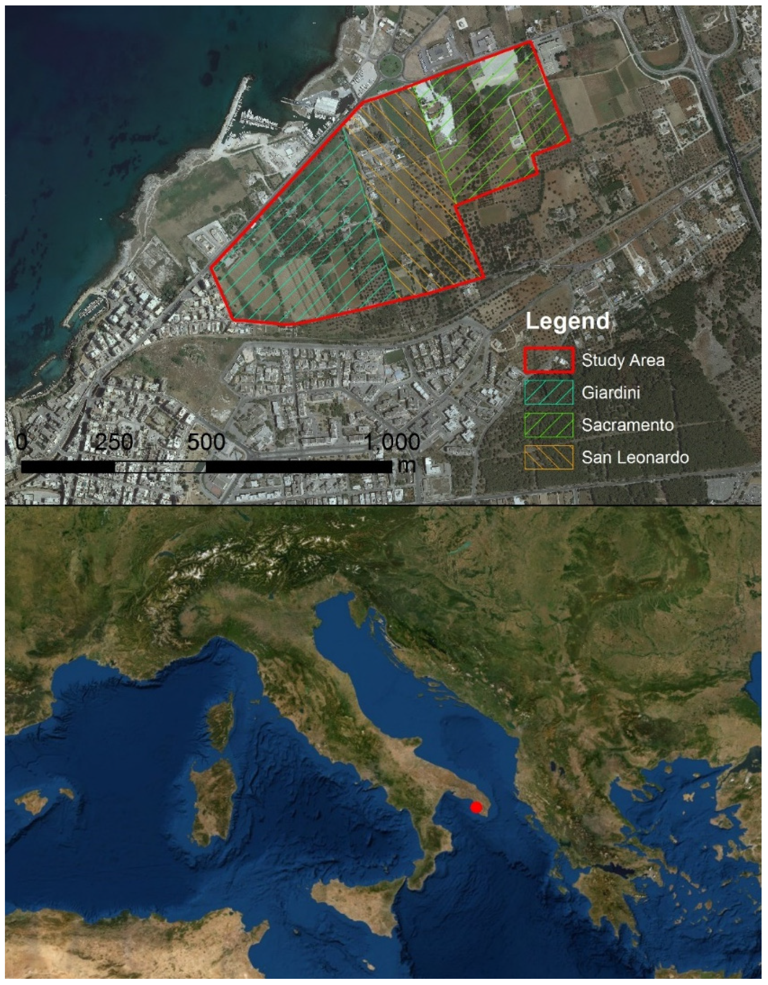
Figure 1. Study area under the urban neighbourhood plan.
Urbansci 06 00023 g001
Figure 2. The methodology applied to analyse the ecosystem services for the neighbourhood-scale plans in a peri-urban area.
Urbansci 06 00023 g002
Figure 3. Spatial configuration of the land uses of the study area.
Urbansci 06 00023 g003
Figure 4. Example of dry olive trees desiccated by X. fastidiosa in the study area.
Urbansci 06 00023 g004
Figure 5. Land use/land cover planned by the urban neighbourhood plan.
Urbansci 06 00023 g005
Figure 6. Land use/land cover change from past scenario to urban neighbourhood plan scenario.
Urbansci 06 00023 g006
Figure 7. Spatial localizations of NbSs considering the urban neighbourhood plan.
Urbansci 06 00023 g007
Figure 8. (A) Example of artistic expression of recovery of a dry olive grove; (B) oak plant grown spontaneously inside a dry olive tree trunk.
Urbansci 06 00023 g008
Table 1. Composition of the land use of the study area.
Land Useha%
Arable lands12.833%
Artificial surfaces6.216%
Fruit trees0.20%
Green urban areas1.23%
Herbaceous vegetation6.617%
Olive Groves10.928%
Shrub0.31%
Vineyards0.92%
Total39.0
Table 2. Qualitative characterization of the ecosystem services provision capacity, linked with the land uses of the study area. Symbols: “-”—no relevant capacity; Urbansci 06 00023 i001—low capacity; Urbansci 06 00023 i002—medium capacity; Urbansci 06 00023 i003—high capacity [16,31,38,40,41,42,43,44,57,58].
ServiceOlive Groves Pre-Xyella FastidiosaOlive Groves Affected by X. fastidiosaArable LandsHerbaceous VegetationFruit TreesShrubArtificial Surfaces (Building; Roads; Parking Areas)Green Urban AreasVineyards
1—Food Urbansci 06 00023 i002- Urbansci 06 00023 i002- Urbansci 06 00023 i002--- Urbansci 06 00023 i002
2—Water ---- ---
3—Raw Materials Urbansci 06 00023 i002 Urbansci 06 00023 i003 Urbansci 06 00023 i001- Urbansci 06 00023 i002--- Urbansci 06 00023 i001
4—Genetic resources Urbansci 06 00023 i002 Urbansci 06 00023 i001 Urbansci 06 00023 i001 Urbansci 06 00023 i001 Urbansci 06 00023 i002 Urbansci 06 00023 i001- Urbansci 06 00023 i001 Urbansci 06 00023 i001
5—Medicinal resources Urbansci 06 00023 i001--- Urbansci 06 00023 i002 Urbansci 06 00023 i001-- Urbansci 06 00023 i001
6—Ornamental resources ---- -- Urbansci 06 00023 i001-
7—Air quality regulation Urbansci 06 00023 i004 Urbansci 06 00023 i005 Urbansci 06 00023 i005 Urbansci 06 00023 i005 Urbansci 06 00023 i006 Urbansci 06 00023 i005- Urbansci 06 00023 i005-
8—Climate regulation Urbansci 06 00023 i004 Urbansci 06 00023 i005 Urbansci 06 00023 i005 Urbansci 06 00023 i005 Urbansci 06 00023 i006 Urbansci 06 00023 i005- Urbansci 06 00023 i005 Urbansci 06 00023 i005
9—Moderation of extreme events Urbansci 06 00023 i006 Urbansci 06 00023 i005 Urbansci 06 00023 i005 Urbansci 06 00023 i005 Urbansci 06 00023 i006 Urbansci 06 00023 i005- Urbansci 06 00023 i005-
10—Regulation of water flows Urbansci 06 00023 i005 Urbansci 06 00023 i005 Urbansci 06 00023 i005 Urbansci 06 00023 i005 Urbansci 06 00023 i005 Urbansci 06 00023 i005- Urbansci 06 00023 i005 Urbansci 06 00023 i005
11—Waste treatment Urbansci 06 00023 i005- Urbansci 06 00023 i005- Urbansci 06 00023 i005----
12—Erosion prevention Urbansci 06 00023 i006 Urbansci 06 00023 i005- Urbansci 06 00023 i005 Urbansci 06 00023 i006 Urbansci 06 00023 i005- Urbansci 06 00023 i005-
13—Maintenance of soil fertility Urbansci 06 00023 i006 Urbansci 06 00023 i005; Urbansci 06 00023 i005 Urbansci 06 00023 i005 Urbansci 06 00023 i006 Urbansci 06 00023 i005- Urbansci 06 00023 i005-
14—Pollination Urbansci 06 00023 i005 Urbansci 06 00023 i005 Urbansci 06 00023 i005 Urbansci 06 00023 i005 Urbansci 06 00023 i006 Urbansci 06 00023 i005- Urbansci 06 00023 i005-
15—Biological control Urbansci 06 00023 i005 Urbansci 06 00023 i005 Urbansci 06 00023 i005 Urbansci 06 00023 i005 Urbansci 06 00023 i005 Urbansci 06 00023 i005- Urbansci 06 00023 i005-
16—Maintenance of life cycles of migratory species Urbansci 06 00023 i002 Urbansci 06 00023 i001 Urbansci 06 00023 i001 Urbansci 06 00023 i001 Urbansci 06 00023 i002 Urbansci 06 00023 i001- Urbansci 06 00023 i001 Urbansci 06 00023 i001
17—Maintenance of genetic diversity Urbansci 06 00023 i001 Urbansci 06 00023 i001 Urbansci 06 00023 i001 Urbansci 06 00023 i001 Urbansci 06 00023 i001 Urbansci 06 00023 i001- Urbansci 06 00023 i001 Urbansci 06 00023 i001
18—Aesthetic information Urbansci 06 00023 i004- Urbansci 06 00023 i005- Urbansci 06 00023 i006 Urbansci 06 00023 i006- Urbansci 06 00023 i005 Urbansci 06 00023 i006
19—Opportunities for recreation and tourism Urbansci 06 00023 i004- Urbansci 06 00023 i005 Urbansci 06 00023 i006 Urbansci 06 00023 i006- Urbansci 06 00023 i005 Urbansci 06 00023 i006
20—Inspiration for culture, art, and design Urbansci 06 00023 i004--- Urbansci 06 00023 i006 Urbansci 06 00023 i006- Urbansci 06 00023 i005 Urbansci 06 00023 i006
21—Spiritual experience Urbansci 06 00023 i004--- Urbansci 06 00023 i006 Urbansci 06 00023 i006- Urbansci 06 00023 i005 Urbansci 06 00023 i006
22—Information for cognitive development Urbansci 06 00023 i004--- Urbansci 06 00023 i006 Urbansci 06 00023 i006 Urbansci 06 00023 i005 Urbansci 06 00023 i006
Table 3. Land use/land cover generated by urban development plan at neighbourhood scale.
Land Urban Planha%
Area not included in the urban plan2.15%
Artificial surfaces14.938%
Fruit trees0.82%
Green urban areas21.154%
Total39.0
Table 4. Transition status under the land use/land cover change from starting point scenario to urban neighbourhood plan scenario. The yellow color indicates the surfaces that have remained unchanged.
ClassUrban Neighbourhood Plan Scenario (ha)
Area Not Included in the Urban PlanArtificial SurfacesFruit TreesGreen Urban Areas
Land Use starting scenario (ha) Arable lands0.15.9 6.7
Artificial surfaces1.42.2 2.5
Fruit trees0.10.10.00.0
Green urban areas0.10.3 0.8
Herbaceous vegetation0.32.7 3.6
Olive Groves0.03.20.86.8
Shrub0.00.2 0.0
Vineyards 0.3 0.5
Table 5. Ecological functions generated with NbSs which can be useful to increase priority ecosystem services (P) and potential co-benefits (C).
Ecosystem ServiceEcological BenefitsEcological FunctionNbSsReferences
1—Food production (C)Provision of natural resources: hunting, game, fruits, etc.
Small-scale subsistence.
Production functions
(Provision of natural resources).
Intensive and extensive green rooves for big buildings.
EIGR. Grasslands; IGR: Sclerophyllous vegetation.
Green Wall: Grasslands.
The use of endemic vegetations with germplasm derivate from the local context.
Creation microhabitat and structure able support local insects and animal using Melliferous, Aromatic Flora
(MAF: Sclerophyllous vegetation).
Creation of Urban Forest Habitat
(UFH: Broad-leaved forests).
Urban community gardens with an attempt to Graft Monumental Olive Trees infected with resistant essences (UG-OT: olive trees).
Urban community gardens with Reforestation: mixed shrub and arboreal agricultural essences and natural flora (UG-R: Fruit trees and berry plantations).
Squares, streets, and parking lots with Grassy Floors
(GF: Grasslands).
Using Flora for Environmental Monitoring
(FEM: Sclerophyllous vegetation).
[7,21,41,42,46,56,61,62,63,64,65,66,67,68,69,70,71,72,73,74,75,76,77,78,79,80,81,82,83]
2—Raw Materials ©
3—Genetic resourc© (C)
4—Medicinal reso©es (C)
6—Ornamental r©urces (C)
7—Air quality regulation (P)Role of ecosystems in bio-geochemical cycles (e.g., CO2/O2 balance, ozone layer, etc.).Regulation functions
Maintenance of essential ecological processes and life-support systems.
8—Climate regulation (P)Maintenance of a favourable local climate (temp., humidity, etc.) for human habitation and health.
9—Moderation of ext©e events (C)Influence of ecosystem structure on Dampening env. disturbances.
Role of vegetation root matrix and soil biota in soil retention.
Role of land cover in regulating runoff and river discharge.
10—Regulation ©water flows (C)Role of land cover in regulating runoff and river discharge.
11©aste treatment (C)Filtering, retention, and storage of fresh water (e.g., in aquifers).
Role of the vegetation in removal or breakdown of xenic nutrients.
12©osion prevention (C)Prevention of damage from erosion/silt.
13—Maintenance of soil fertility Maintenance of healthy soils and productive ecosystems.
14—Pollination (C)Role of biota in movement of floral gametes thus pollination of crops.Habitat functions
(Providing habitat (suitable living space) for wild plant and animal species).
15—Biological control (C)Population control through trophic–dynamic relations.
17—Maintenance of genetic diversity (C)Suitable living space for wild plants and animals.
Suitable reproduction habitat.
Genetic material and evolution in wild plants and animals.
18—Aesthetic information (P)Attractive landscape features.
Variety in landscapes with (potential) recreational uses.
Variety in natural features with cultural and artistic value.
Variety in natural features with spiritual and historic value.
Variety in nature with scientific and educational value.
Living space (ranging from small settlements to
urban areas).
Social activities (outdoor sports, beach tourism, etc.).
Information and carrier functions:
Providing opportunities for cognitive development;
providing a suitable substrate or medium for human activities and infrastructure.
19—Opportunities for recreation and tourism (P)
20—Inspiration for culture, art, and design (P)
21—Spiritual experience (P)
22—Information for cognitive development (P)
Table 6. Analysis of CO2 sequestration considering the land use/land cover under different scenarios. We have considered the land use/land cover scenarios by including olive groves in good status (past scenario), olive groves affected by X. fastidiosa (current situation—scenario 0), actions foreseen by the urban plan (scenario 1), and the urban plan integrated with NbSs (scenario 2).
CO2 sequestration (Past scenario) CO2 sequestration (Scenario 0)
Land Use pre X. fastidiosahat/hat Land Use post X. fastidiosahat/hat
Arable lands12.85.0063.8 Arable lands12.85.0063.8
Artificial surfaces6.20.000.0 Artificial surfaces6.20.000.0
Fruit trees0.2213.5 Fruit trees0.2213.5
Green urban areas1.26.607.9 Green urban areas1.26.607.9
Herbaceous vegetation6.60.000.0 Herbaceous vegetation6.60.000.0
Olive Groves10.951.50560.3 Olive Groves (Xyella fastidiosa)10.96.6071.8
Shrub0.317.743.0 Shrub0.317.743.0
Vineyards0.921.0018.0 Vineyards0.921.0018.0
Total39.0 679.8 Total39.0 170.30
CO2 sequestration (Scenario 1) CO2 sequestration (Scenario 2)
Land Urban Planhat/hat Land Urban Planhat/hat
Area not included in the urban plan2.100.0 Area excluded from the plan2.300
Artificial surfaces14.900.0 Area pertaining to the building0.800
Fruit trees0.82117.6 EGR (Grasslands)2.13.046.52
Green urban areas21.16.6139.4 FH (Broad-leaved forests)7.428.24209
Total39.0 157.0 GF (Grasslands)2.93.048.74
IGR (Sclerophyllous vegetation)2.117.7437.4
MAF (Sclerophyllous vegetation)4.217.7474.5
MAF-FEM (Sclerophyllous vegetation)0.717.7411.9
UG-R (Fruit trees and berry plantations)4.72198.9
UG-OT (Olive trees)4.851.5246
urban road network7.000
Total39 693
Publisher’s Note: MDPI stays neutral with regard to jurisdictional claims in published maps and institutional affiliations.