Article

Urban Residential Mobility: The Case of the Alifana in the Province of Caserta (Campania Region)

Department of Architecture and Industrial Design, University of Campania “L. Vanvitelli”, 81100 Caserta, Italy
*
Author to whom correspondence should be addressed.
Urban Sci. 2026, 10(7), 354; https://doi.org/10.3390/urbansci10070354
Submission received: 28 April 2026 / Revised: 8 June 2026 / Accepted: 23 June 2026 / Published: 25 June 2026
(This article belongs to the Section Urban Mobility and Transportation)

Abstract

In recent decades, residential mobility has emerged as a fundamental interpretative key lens for understanding contemporary urban transformations, particularly in polycentric and fragmented urban contexts. Movements between different residential settings reflect economic, social and cultural changes, impacting the organisation of urban spaces, the demand for services and mobility systems. In territories characterised by dispersed settlement patterns and strong functional polarisation, these dynamics tend to promote the intensive use of private means, with consequent negative impacts on environmental sustainability, social equity and economic efficiency. In response to these critical issues, there is growing interest in sustainable mobility models based on proximity and on the integration between daily travel, access to services and the quality of public space. Within this perspective, greenways are configured as hybrid infrastructures, capable of reorganising mobility while contributing to the regeneration of urban spaces. In the Caserta area, in the Campania region, the disused route of the former Alifana railway represents a topic of great interest, both for research and planning. Its potential strategic conversion into a greenway opens a broader perspective than that so far considered at the regional level, which has mainly focused on the infrastructure dimension. The paper analyses the strengths and weaknesses of an approach limited to infrastructural mobility, proposing a comparative evaluation of project scenarios—including the non-intervention hypothesis—both through the application of the MACBETH approach and preliminary parametric estimation of construction costs, in order to emphasise the importance of integrating social and environmental benefits, as well as quality of life, into decision-making processes.

1. Introduction

Infrastructure interventions constitute a crucial element for the economic and social progress of cities, as they directly affect territorial accessibility, the mobility of people and goods, and the competitiveness of businesses [1]. These interventions include not only the construction and upgrading of road, rail, port, and airport networks, but also the development of digital and energy infrastructures, which are increasingly essential to support technological transformation and the ecological transition. The planning of such works requires a rigorous cost–benefit analysis, with particular attention to environmental, social, and economic sustainability. It is essential to assess not only the immediate impact of infrastructure, but also its long-term durability, efficient management, and continuous maintenance—elements that recent studies identify as decisive in translating infrastructure investments into real economic growth [2,3].
An emblematic example of sustainable infrastructure is represented by greenways—linear green corridors designed to promote soft mobility, such as walking, cycling, or the use of light ecological vehicles—and to connect urban areas, natural parks, and sites of cultural interest. These infrastructures not only encourage sustainable travel, but also play a significant role in biodiversity protection, climate change mitigation, and the regeneration of degraded areas [4,5]. Empirical evidence shows that infrastructure interventions can positively impact local tourism, improve urban quality of life, and strengthen social cohesion through the creation of accessible and safe public spaces. At the European level, the promotion of such interventions falls within integrated territorial development strategies aimed at combining sustainable transport, territorial enhancement, and environmental protection, as highlighted in the European Commission’s guidelines on cycling mobility and urban green networks [6]. Whether traditional or innovative, these interventions represent strategic tools not only to stimulate the economy, but also to promote harmonious, inclusive, and sustainable development capable of addressing present and future environmental and social challenges [7,8].
In the Caserta area, the disused route of the former Alifana railway, in the section between Aversa and Santa Maria Capua Vetere in the Campania region, represents a strategic infrastructure in this regard. Historically conceived as a supra-local crossing and connecting axis, the Alifana now traverses a complex territorial system composed of a plurality of heterogeneous residential contexts, consolidated neighbourhoods, urban fringe areas, and transforming urban fabrics. The conversion of this axis into a greenway could provide an opportunity to transform a linear infrastructure into a backbone of residential mobility, capable of connecting living spaces and local services [9]. Reimagined as a continuous and accessible green corridor, the Alifana could perform a dual function: on the one hand, facilitating daily non-motorised travel among different residential centres; on the other, acting as a territorial stitching device, reducing spatial discontinuities and strengthening the sense of belonging and proximity among diverse communities. From this perspective, the greenway is configured not merely as an infrastructural intervention, but as an instrument of urban and territorial design, capable of influencing residential mobility dynamics, settlement choices, and, more broadly, the quality of contemporary living.
Understanding the impact of territorial transformation, however, requires a rigorous methodological approach capable of interpreting the complexity of the urban, environmental, and socioeconomic dynamics involved. Interventions such as the conversion of the disused route of the former Alifana railway into a greenway cannot be assessed solely on the basis of immediate economic parameters; rather, they require an integrated approach able to incorporate multiple dimensions: accessibility, environmental sustainability, residential quality, social cohesion, safety, technical feasibility, and financial sustainability throughout the life cycle of the project. In this context, the multi-criteria decision analysis methodology emerges as the most appropriate approach to support the decision-making process, as it enables the comparison of different design alternatives through the identification of criteria consistent with the strategic objectives of the intervention, the assignment of weights according to territorial priorities, and the construction of a transparent and replicable evaluation framework [10,11,12,13]. This methodological framework is consistent with the principles introduced in Italy in the field of public works and reaffirmed by the new Public Contracts Code (Legislative Decree 36/2023) [14], which, under Article 108, regulates the criterion of the Most Economically Advantageous Tender (MEAT) for projects exceeding the threshold of €150 million, based precisely on a multi-criteria logic aimed at achieving the best quality–price ratio.
The adoption of a multi-criteria analysis thus makes it possible to overcome a sectoral view of infrastructure intervention, placing the transformation of the former Alifana within an integrated territorial development perspective [15,16,17]. The greenway is therefore considered not merely as infrastructure for soft mobility, but as a strategic device capable of influencing spatial relationships, the quality of living, and opportunities for the economic and environmental enhancement of the Caserta area. In this sense, it connects to the broader concept of green infrastructure in territorial planning and ecosystem services management, offering practical examples and methodologies for integrating green networks into sustainability and spatial planning strategies [18].
Thus, the methodology is not configured solely as an ex-post verification tool, but assumes a strategic role already in the ex-ante stage, guiding the very definition of planning choices and becoming an integral part of the design process [19,20,21], steering the selection of alternatives most consistent with objectives of environmental sustainability, economic balance, enhancement of residential well-being, and social cohesion.

2. Literature Review: Residential Mobility and Greenways

Residential mobility is a structural component of urban organisation and concerns the set of daily trips that originate from the place of residence toward services, workplaces, schools, commercial activities, and spaces for social interaction. It represents a significant indicator of urban quality, as it reflects the degree of accessibility, functional proximity, and integration between housing and services [22,23,24].
In terms of sustainable planning, residential mobility is not understood solely as traffic flow, but as a system of spatial relationships that affects public health, social equity, and environmental performance. Within this framework, greenways can play a strategic role as infrastructures capable of reshaping proximity–mobility dynamics. They function as multifunctional linear systems able to connect different territorial areas, integrating ecological and social functions [25,26]. When applied to residential contexts, these networks promote active modes of travel—walking and cycling—reducing dependence on private cars and contributing to lower greenhouse gas emissions and air pollution [27]. The literature highlights that the spatial configuration of neighbourhoods decisively influences mobility behaviours: balanced density, functional mix, and the presence of continuous green networks increase the likelihood of choosing sustainable transport modes [28,29]. From this perspective, greenways are not simple recreational corridors, but structuring devices of urban form, capable of linking homes, schools, parks, and public services through safe and accessible routes. Experiences in the reuse of disused infrastructure, such as rail-trails [30,31], show that these interventions can strengthen cohesion among districts, increase perceived safety, and stimulate urban regeneration processes [32]. Beyond transport-related effects, residential mobility supported by greenways generates social and health benefits: it promotes daily physical activity, encourages interaction among different generational groups, and strengthens a sense of belonging to places [33,34]. This results in an integrated model in which ecological infrastructure and mobility infrastructure coincide, contributing to the creation of resilient, inclusive communities oriented toward quality of life. The case of the Atlanta BeltLine in Georgia (USA) is one of the most emblematic examples: the conversion of a disused railway loop into a network of pedestrian and cycling paths has made it possible to reconnect residential quarters that were historically separated, improving access to services and encouraging daily non-motorised travel. It is not conceived as a simple recreational space, but as a structuring axis that integrates active mobility, public transport, and urban regeneration strategies, concretely influencing residents’ travel habits [35].
Of comparable relevance is The 606–Bloomingdale Trail in Chicago (USA), an elevated linear infrastructure built on a disused railway that runs through high-density residential neighbourhoods. The project has improved the city’s east–west connectivity and provided a safe and continuous corridor for home-to-school and home-to-work trips, showing how a greenway can function as a real transport alternative for everyday mobility. Empirical studies indicate a significant increase in cycling and pedestrian use along the route, with positive effects on the quality of public space and the vitality of the surrounding districts [36]. A further example is the restoration of the Cheonggyecheon Stream in Seoul (South Korea), where the demolition of an elevated highway and the reinstatement of the watercourse created a linear green corridor in the heart of the city. The intervention led to a reduction in vehicular traffic in the central area and a substantial increase in pedestrian movement, reshaping urban mobility dynamics and strengthening residents’ use of public spaces [37]. In this case, the greenway performed a systemic function, contributing to the transition toward an urban model less dependent on the automobile and more oriented toward proximity-based mobility.
In the same vein, the Italian context also offers significant examples where greenways fulfil an integrated role linking transport, ecology and quality of life. The Airasca–Moretta greenway, now known as the ‘Via delle Risorgive’, originated from the conversion of the Airasca–Moretta–Cavallermaggiore railway line, originally some 34 km long, built in the second half of the 19th century (opened 1885–1886) and closed permanently on 1 January 1986 following a gradual phasing-out between 1961 and 1987. It was a diesel-powered line, connected to the Turin–Ceva and Turin–Pinerolo railway networks, but it was unprofitable and was eventually closed. Today, the route serves as a sustainable transport infrastructure that combines regional development with the historical legacy of the old railway line. The route is approximately 19 km long, running between the Metropolitan City of Turin and the Province of Cuneo. It has an average width of 3.5 m and is completely flat, making it suitable for a wide range of users. Along the route, elements of the old railway such as stations, toll booths, signals and level crossings are still present. The redevelopment was carried out by the Piedmont Region as part of the 2007–2013 Regional Operational Programme (PAR) and the Integrated Territorial Programme, “A.I.R. P.L.U.S. P.I.A.N.U.R.A.”, with the involvement of bodies such as the Metropolitan City of Turin, the Municipality of Villafranca Piemonte and the Po Cuneese Park Authority. The works were carried out in several phases: dismantling of the tracks (late 1990s–2011), preparation of the sub-base and laying of the asphalt surface (2011–2013), followed by the 2015 expropriation decree, with the official inauguration taking place on 18 November 2017.
From a technical point of view, approximately 75% of the route (12 km) was completed by the Metropolitan City of Turin, involving ground stabilisation works and asphalting up to the wearing course; on the Cuneo section, the Municipality of Moretta carried out similar works following clearance and weed control. The total investment amounted to approximately €2.6 million, of which €774,000 was spent on acquiring the land, at an average cost of around €95 per square metre. Another notable example is the Montebelluna–Nervesa ‘La Tradotta’ Battle Greenway, created by converting the disused Montebelluna–Susegana railway line in Veneto. The railway was built in 1916 during the First World War, played a part in the Battle of the Solstice (1918) and was restored in 1920. Passenger services ceased in 1966, and the line was finally decommissioned in 1984, entering a long period of neglect. The reuse project was promoted by the Bosco del Montello Consortium with the aim of enhancing the route and promoting soft mobility. The railway land was acquired in 2016, whilst work began in 2020. Today, the greenway stretches for 15.4 km along the former railway line, and a distinctive feature is the preservation of its historical heritage: in some sections, the tracks are still present, and the route has been built alongside the old infrastructure, keeping it visible. Significant safety improvements have been carried out, including the upgrading of 22 road junctions, the restoration of an overpass on the SR 348 and three bridges over minor watercourses, ensuring accessibility and continuity of the route.
From an economic standpoint, the project had a total cost of around €400,000 equivalent to approximately €26,000 per kilometre, funded by the BIM Piave Consortium and the Municipality of Montebelluna. The project stands out for its cost-effectiveness and its positive impact on sustainable tourism and the quality of the local area. Looking ahead, the Montebelluna–Nervesa della Battaglia greenway is envisaged as part of a wider cycle and pedestrian network along the River Piave and the Montello, with the aim of creating an integrated system for soft mobility and landscape enhancement. Another example, in line with the article, is the Poggibonsi–S. Gimignano–Colle Val d’Elsa Greenway in Tuscany, built on the disused Empoli–Siena railway line, which is approximately 8 km long. The line was opened in 1885 with the intention of extending it towards Volterra, a project that was never completed. After being transferred to Ferrovie dello Stato in the 1930s, it remained in operation until 1987 and was finally closed in 2009. The conversion process was gradual: the first attempts at repurposing the line for tourism began in the 1990s, whilst in 2002 the Italian Greenways Association carried out a feasibility study for its conversion into a cycle and pedestrian path. The project was then included in the Alta Valdelsa PIUSS and made possible thanks to the acquisition of the railway land by the municipalities of Poggibonsi and Colle Val d’Elsa. The greenway was opened in 2011. Today, the route stretches for 6.9 km, almost entirely following the original route between Poggibonsi and Colle Val d’Elsa, along the Elsa River valley. The path, approximately 2.5 m wide, largely follows the old railway line with coloured concrete and exposed gravel surfacing, whilst some sections are made of asphalt. Historical elements such as sections of track and information panels have been restored, alongside work on three bridges, including two multi-arch crossings over the River Elsa, which have been adapted for cycle and pedestrian use. The route is complemented by signage, street furniture and safety features. The total investment amounted to approximately €640,000, financed mainly by POR funds and a contribution from the Monte dei Paschi di Siena Foundation. The low cost has enabled a significant positive impact on tourism and landscape enhancement. The greenway is now integrated into the Valdelsa cycle and pedestrian network, linked to the Via Francigena and the European EuroVelo 5 route, playing a strategic role in soft mobility and sustainable tourism on a wider scale [38].
A comparative analysis of these experiences shows that the ability of greenways to influence residential mobility depends on several recurring factors: spatial continuity, integration with public transport, direct accessibility from residential districts, and the presence of services distributed along the route. When these conditions are met, the greenway takes shape as a hybrid infrastructure—ecological, social, and transport-related—capable of improving urban accessibility, promoting active lifestyles, and strengthening environmental resilience. From this perspective, residential mobility supported by greenways represents not only a modal alternative, but a structural element of urban transformation, in which green infrastructure becomes a device for spatial reorganisation and for enhancing the lived experience of dwelling [39].

3. Materials and Methods

3.1. The Alifana Case Study: Territorial Framework and Alternative Project Analysis

The Alifana railway runs through the Campania region along an infrastructure corridor of approximately 45–50 km, which, starting from the city of Naples, extends inland towards the Matese mountains as far as Piedimonte Matese (formerly Piedimonte d’Alife). The route crosses a stretch of land characterised by marked morphological and functional diversity, forming a distinct territorial section that connects the Naples metropolitan area to the rural and mountainous landscapes of the Upper Caserta region [40]. Historically, the line was inaugurated in 1913–1914 as part of a wider early 20th-century infrastructure modernisation project, aimed at integrating inland areas into the regional economic system. The railway was divided into two distinct sections: the so-called Bassa Alifana, approximately 20 km long, electrified and featuring more modern characteristics, which connected Naples to Santa Maria Capua Vetere; and the Alta Alifana, approximately 25–30 km long, steam-powered, which continued inland as far as Piedimonte Matese. This distinction reflected not only technological differences but also the different territorial roles of the two sections: the former being more urban and metropolitan, the latter closely linked to the agricultural and productive systems of the hinterland. The project represented a strategic piece of infrastructure for its time, designed to support agricultural development, facilitate the movement of goods and people, and strengthen links between Naples and the inland areas, at a time when the latter were still on the periphery of the main economic circuits. However, from the second half of the twentieth century onwards, the line experienced a gradual decline: the Alta Alifana was permanently decommissioned in the 1970s (1976), whilst the Bassa Alifana was largely replaced by a new railway infrastructure with a different route, now managed by Ente Autonomo Volturno (EAV) [41]. Consequently, large sections of the original right-of-way are now abandoned, interrupted or incorporated into subsequent urban and infrastructural developments.
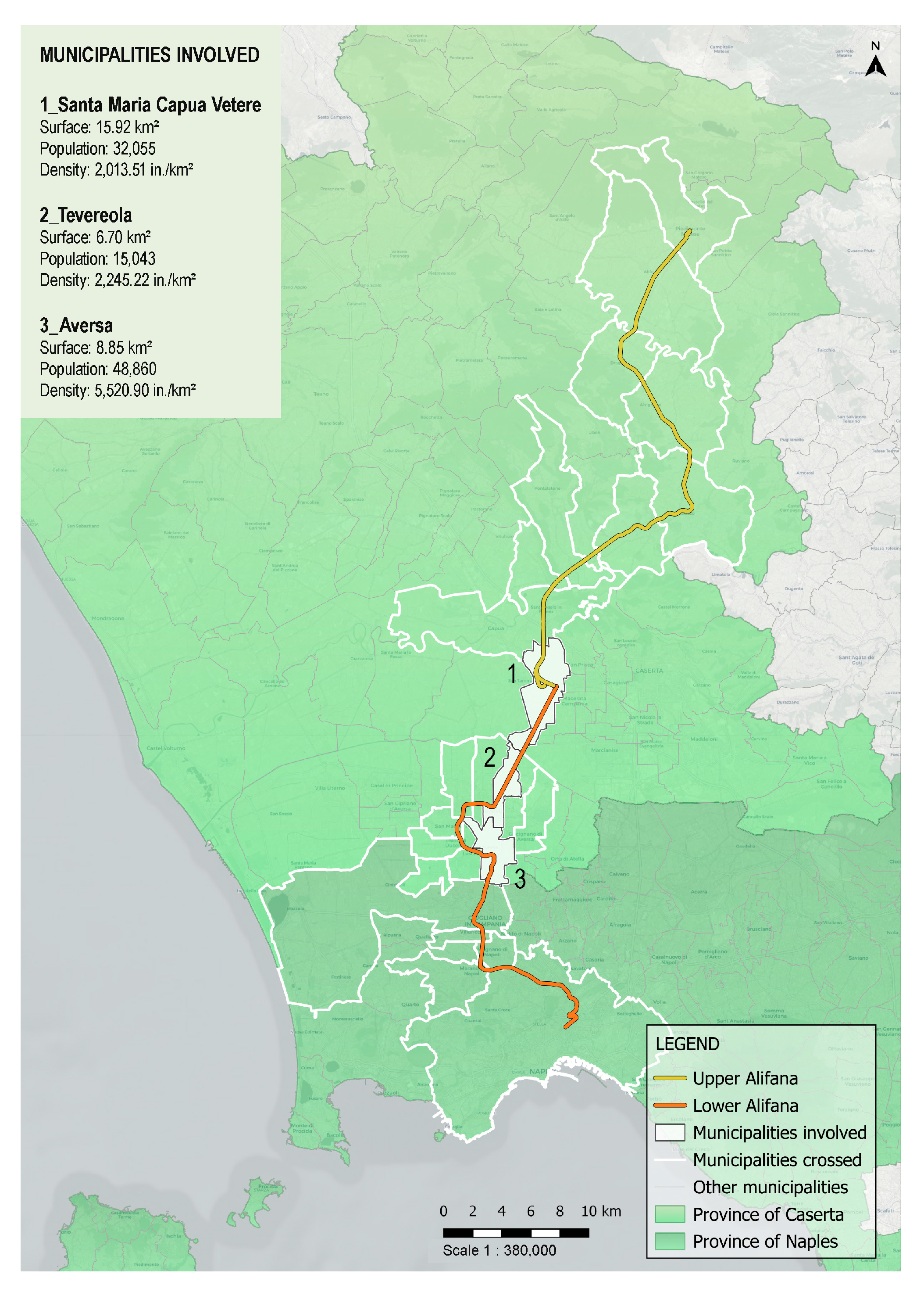
At present, the old historic route—shown in Figure 1—is only partially discernible: in some sections it has disappeared completely, in others it survives as residual infrastructure, whilst in certain parts it has been misused or transformed into an urban fringe. This state of discontinuity makes it a particularly significant element for interpreting the territorial transformations that took place during the 20th century, especially in relation to the processes of widespread urbanisation that affected the Caserta plain. Along its route, in fact, a succession of highly diverse landscapes unfolds: industrial and manufacturing areas that developed mainly after the Second World War, agricultural fields still in use, established urban fabrics, and peri-urban spaces characterised by a coexistence of functions and a fragmented structure. It is precisely in these peripheral areas, where city and countryside overlap and intermingle, that the Alifana corridor takes on the role of a latent territorial mechanism, capable of revealing not only the discontinuities but also the potential connections between different systems [40]. In the area stretching from Aversa to Teverola, Santa Maria Capua Vetere and Capua, the issue of revitalisation takes on even greater significance, as it forms part of a polycentric urban system with a high functional density. This area is home to numerous supra-municipal centres of attraction, including courts, hospitals, universities and educational institutions, which generate significant daily flows and help to shape a complex but not fully integrated territorial system [42,43,44,45].
In the Italian context, urban planning is governed by a multi-level system, in which the provinces provide general guidelines and policy directions, whilst operational responsibility and the approval of urban planning instruments are delegated to individual municipalities. In the case study, this structure results in significant heterogeneity in spatial planning. The various municipal urban planning instruments are, in fact, approved at different times and with varying levels of updating, a condition that affects the consistency of the analysed data and must be taken into account when interpreting the results. This fragmentation is not only regulatory and temporal, but is also reflected in the physical and functional structure of the territory, characterised by discontinuities in settlement patterns and weak integration between the various urban centres. In this context, the reactivation—even if partial or in the form of light infrastructure (greenways, soft mobility, local transport)—of the former Alifana railway line would not merely represent an infrastructure regeneration project, but could serve as a strategic response to this very condition of territorial discontinuity. The railway line, in fact, has the potential to strengthen links between the various urban centres, improve access to services and contribute to a physical and functional reconnection between urban and rural areas that are currently fragmented [46].
  • The non-intervention hypothesis (transformative suspension).
The first option, based on the non-intervention hypothesis, can be interpreted not simply as the absence of planning, but as a form of conscious passive management of the infrastructure site. The section under consideration, between Aversa and Capua, extends for a length of approximately 15–18 km, with a variable width averaging between 8 and 15 m, forming a continuous linear strip that is currently only partially accessible. In the absence of intervention, this corridor tends to evolve spontaneously into an informal ecological infrastructure: progressive vegetation colonisation favours secondary succession processes, with the formation of semi-natural habitats that can contribute to the ecological connection between agricultural fragments and residual green areas. In potential terms, the site could serve as an ecological corridor at a local scale (15–20 km), facilitating species movement and enhancing biodiversity within a heavily human-altered environment.
From the perspective of human use, however, usage remains extremely limited and unstructured: it consists mainly of informal and sporadic uses (crossings, spontaneous routes), amounting to a few dozen users a day, scattered intermittently along the route. The infrastructure, therefore, does not meet an organised demand for mobility or public space and does not capture the significant flows generated by the urban centres it passes through. This choice implicitly addresses a collective interest of an environmental and conservationist nature—reduction in land consumption, absence of new sealing, containment of public costs—but presents significant limitations in terms of safety, accessibility and the ability to address socio-spatial challenges. The main risk is that of reinforcing conditions of marginalisation, transforming the site into a residual space, unregulated and progressively excluded from active urban dynamics.
2.
The Tram Line Project Aversa–Teverola–Santa Maria Capua Vetere–Capua.
The second option corresponds to the tram line project promoted by Ente Autonomo Volturno (EAV), which involves the construction of a light rail system along a route of approximately 10–12 km, partly following the route of the former Alifana line. The project, submitted under a national funding programme for Mass Rapid Transit and Fixed Facilities (although not approved), aims to complete the historic Naples–Santa Maria Capua Vetere rail connection by converting the unfinished Aversa–Santa Maria Capua Vetere section of the former Alifana railway into a tram line, thereby restoring continuity to the rail network serving the Caserta area. The system is configured as a light rail system, with around 10–12 stops and a fleet of approximately eleven vehicles, as well as a depot and workshop located in the Teverola area.
From a transport standpoint, the line is designed to meet significant commuter demand, serving a densely populated catchment area (over 200,000 inhabitants, taking into account the municipalities served directly and indirectly). In terms of capacity, a system of this type can carry approximately between 1500 and 3000 passengers per hour in each direction, with a potential daily demand estimated at between 20,000 and 40,000 users, depending on the frequency of the service and the level of integration with the existing network. The infrastructure primarily serves: commuters travelling to Naples and Caserta; university and secondary school students; users of the health, judicial and administrative services located in the hubs along the route; and workers in local industrial and manufacturing areas.
The main objective is to improve accessibility and reduce reliance on private transport, with the expected benefits of reducing traffic, emissions and journey times. Furthermore, integration with the regional rail network enhances intermodality, embedding the corridor within a broader transport system. However, the project is primarily conceived as a sectoral intervention: whilst having a significant impact on mobility patterns and the functional connection between urban centres, it tends to overlook the spatial and landscape dimensions of the site. The risk is that of a ‘closed’ infrastructure regeneration, lacking permeability and with limited benefits for the quality of public space and widespread urban regeneration.
3.
The Green Urban Stitch Project—greenway and linear park.
The third design option, known as “Green Urban Stitch”, proposes the complete conversion of the site into a greenway, shaping it as a continuous ecological and cultural corridor approximately 15–18 km long, with an average width of 10–20 m. The project involves the creation of a continuous cycle and pedestrian path (3–5 m wide), flanked by green belts, equipped spaces and environmental features. In terms of users, the greenway is aimed at an extremely broad and diverse catchment area: local residents, students, families, sports enthusiasts, occasional users and local tourism. Given the area’s population density and similar projects, it is reasonable to estimate daily usage of between 1000 and 5000 users in the most central sections, with peaks at weekends and during favourable seasons. The infrastructure serves a variety of functions: everyday soft mobility (local journeys between home and school, home and work); sporting and recreational activities; environmental education and educational use; local production (urban gardens, local agriculture); and social inclusion and the activation of community spaces. The project is structured around thematic hubs—memory, community, contemplation and inclusion—distributed along the route and designed to address specific local needs.
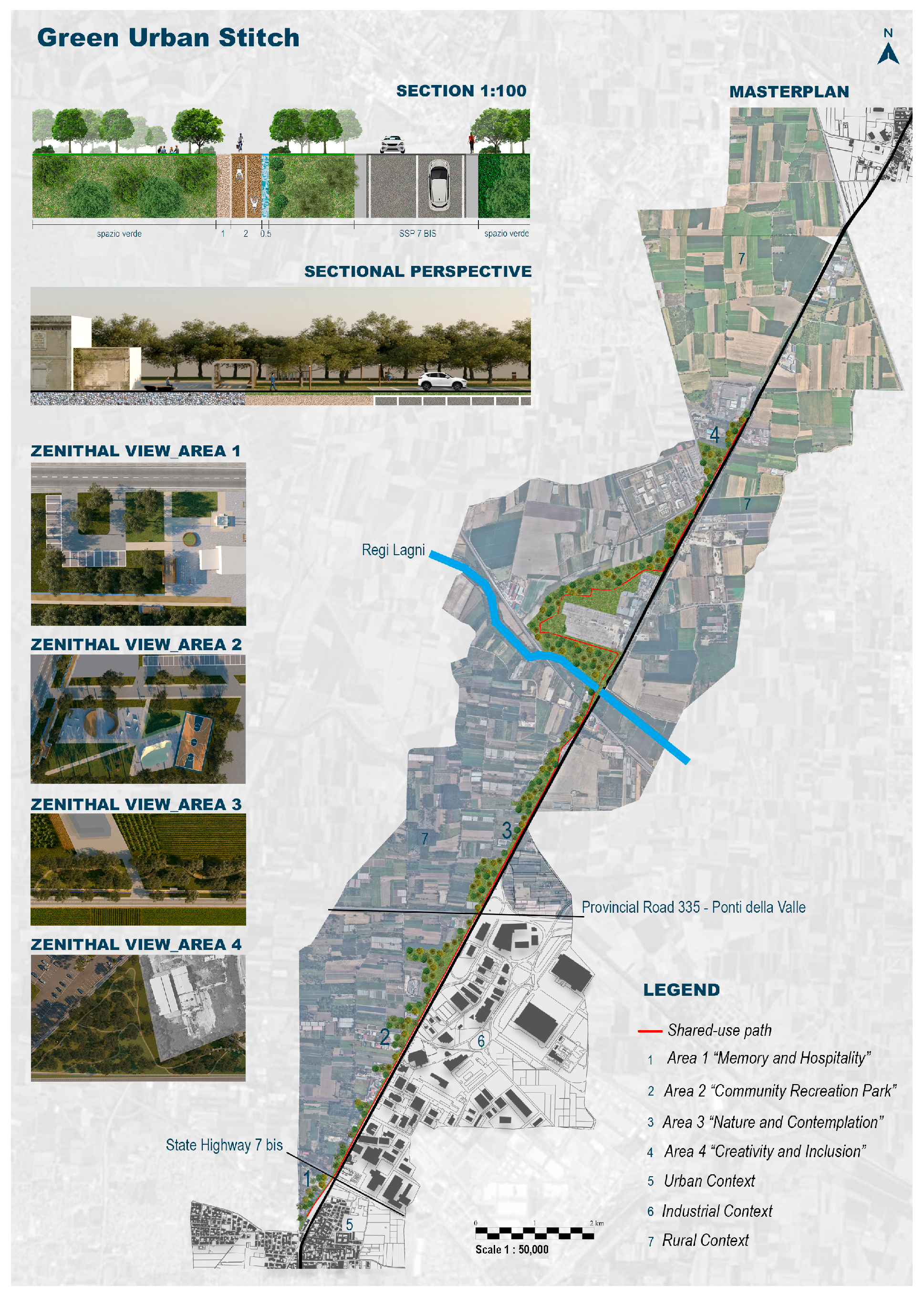
These are complemented by technical features such as permeable paving, low-energy lighting systems and green infrastructure for water management (construction of constructed wetlands, rain gardens), contributing to the environmental resilience of the area. Unlike the tramway solution, the Green Urban Stitch does not merely address a mobility need, but redefines the very role of infrastructure as a linear public space and a relational framework. The route thus becomes a structure of ecological, social and cultural connection, capable of stitching together urban fragments, improving environmental quality and strengthening the identity of places, as illustrated in the project layout shown in Figure 2.
The comparison among the three alternatives highlights different paradigms of intervention on disused infrastructure: conservation and spontaneous denaturalisation; functional reactivation oriented toward mobility; and integrated landscape reconversion. These do not represent merely technical alternatives, but rather different conceptions of the role of infrastructure within the territory, each with distinct implications for the configuration and relative weight of the provincial urban system.

3.2. Application of the MACBETH Method for the Impact Assessment of Alternatives on the Housing Well-Being

In a scenario characterised by increasing complexity in organisational systems and public investment choices, the decision-making process requires methodologically robust tools capable of reducing risks and uncertainty, and of supporting rational, transparent, and justifiable decisions [16,19]. Several evaluative approaches can be used to support decision-making processes, enabling the structuring of alternative analyses, the integration of quantitative and qualitative data, and the simultaneous consideration of multiple criteria [47,48,49]. Among these, multi-criteria decision analysis is one of the most important decision-support techniques, widely used by institutions, academics, and researchers, particularly in the evaluation of projects related to the development of urban facilities, public or transport services, and the implementation of environmental sustainability measures [50,51,52,53]. Furthermore, applications of multi-criteria decision analysis are successful in many political decision-making contexts [54], used as a support tool in decision-making conferences, to elicit qualitative judgments about the desirability of policies [55].
For this study, we chose the MACBETH (Measuring Attractiveness by a Categorical Based Evaluation Technique), a multi-criteria approach, which uses semantic judgments about differences in attractiveness of different alternatives or factors, in order to help a decision maker quantify the relative attractiveness of each one [12,15]. Unlike other Multi-Criteria Decision Analysis (MCDA) approaches, it stands out for its ability to construct numerical value scales based on pairwise comparisons [56,57].
In this specific case, this approach was selected precisely with the aim of evaluating more than one design hypothesis in comparison with the non-intervention option, while simultaneously considering a series of quantitative and qualitative indicators describing the expected performance of the proposed alternatives. The main objective of this application is to propose the simulation of a multi-criteria decision analysis method to assist the public administration of the Province of Caserta in navigating among different alternatives and determining the most advantageous option in terms of benefits for the community and the enhancement of various public domains [58].
Within this context, a central role is assumed by the concept of housing well-being, understood as the result of multiple interacting factors: territorial characteristics, individual perceptions of satisfaction and well-being, and economic sustainability. The relationship between personal well-being and place of residence is essential to understanding citizens’ needs. The place where one lives, in fact, affects not only the material aspects of life, but also the psychological and social ones. Elements such as the availability of services, environmental quality, green spaces, safety, and a sense of community significantly influence perceived well-being and residential choices.
Therefore, life quality can be understood as the level of satisfaction that individuals derive from the context in which they live, shaping the behaviours of individuals, households and economic actors [24]. Since, currently, only the hypothesis of an infrastructural intervention—mainly focused on the implementation of public rail transport—has been explored, this contribution investigates the possibility of acting also in other potential domains influencing housing well-being.
Consequently, the decision problem is defined not as the identification of “the best design alternatives”, but rather as the identification of the factors capable of maximising the overall benefits. Considering this purpose, the analysis conducted using the MACBETH approach excludes intervention costs, not as an arbitrary simplification, but as an informed methodological choice [59,60]. This choice is dictated by the need to focus the evaluation on the impacts generated by the interventions, especially those of a more intangible and long-term nature, which are often underestimated in traditional analyses, oriented towards strictly economic–financial considerations.
At the same time, it is important to consider that, in public planning, costs can be highly variable, as they are linked to exogenous factors, such as the funding sources, implementation timelines, and governance tools. For this reason, Section 3.3 presents a preliminary parametric estimate for the implementation of the different alternative project scenarios considered. Although the analysis is framed as a benefit-oriented evaluation—aimed at supporting more informed strategic decisions consistent with sustainable development goals and the improvement of housing well-being—it is essential to understand the resources potentially required for each alternative project, which will be denoted as follows:
  • Non-intervention hypothesis (conservative option).
  • Tram Line Project Aversa–Teverola–Santa Maria Capua Vetere–Capua EAV hypothesis (transport–infrastructural option).
  • Green Urban Stitch Project hypothesis (landscape-ecological option).
Starting from the non-intervention hypothesis—therefore maintaining the current infrastructural and environmental conditions of the area under consideration—the two selected projects were analysed separately [61,62]. A set of descriptive characteristics for each project was identified, and the main potential impacts resulting from the alteration of the current situation were hypothesised. Subsequently, a series of criteria suitable for evaluating the impacts of each intervention under consideration were developed [63].
Given that these are preliminary design hypotheses—thus assuming an initial, non-detailed and embryonic level of planning—and considering that this contribution has an illustrative purpose regarding the application of the MACBETH method, the simplest case of analysis was adopted, using one-dimensional qualitative descriptors [17,59]. For the purposes of the assessment objective, it was sufficient to develop dichotomous descriptors—therefore considering only two levels of impact—in order to determine the possible “positive/expected” or “negative/unexpected” impacts of each criterion with respect to the different design alternatives considered, so as to understand whether the consequences of an option were anticipated or not.
Following the fundamental steps for constructing the evaluation model according to the MACBETH method [58,60], the desirable and strategic objectives in the implementation of a sustainable mobility intervention were investigated. Based on the analysis of the parameters set out in the Sustainable and Smart Mobility Strategy [6], a series of policy objectives and related key-performance indicators (KPIs) were selected, potentially associated with the aims of the case study, as reported in Table 1.
The main policy objectives identified were adopted as key concerns, allowing the structuring of the evaluation framework into four dimensions (or macro-criteria):
  • Environmental (ENV).
  • Economic (ECO).
  • Mobility and accessibility (MOB).
  • Social and life quality (SOC).
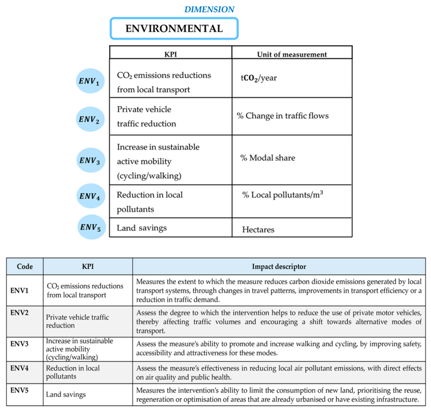
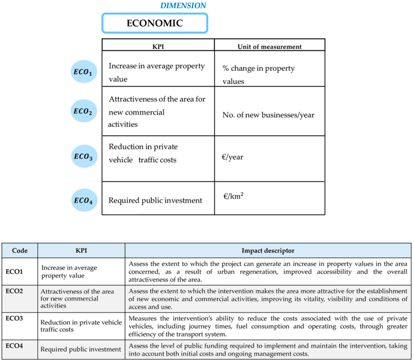
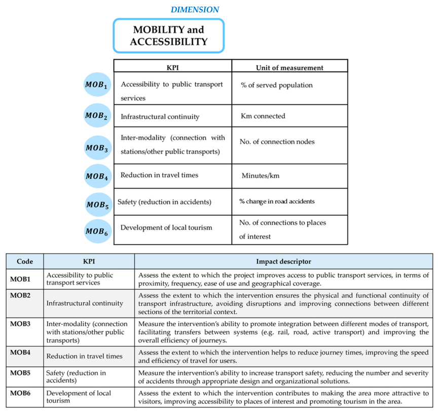
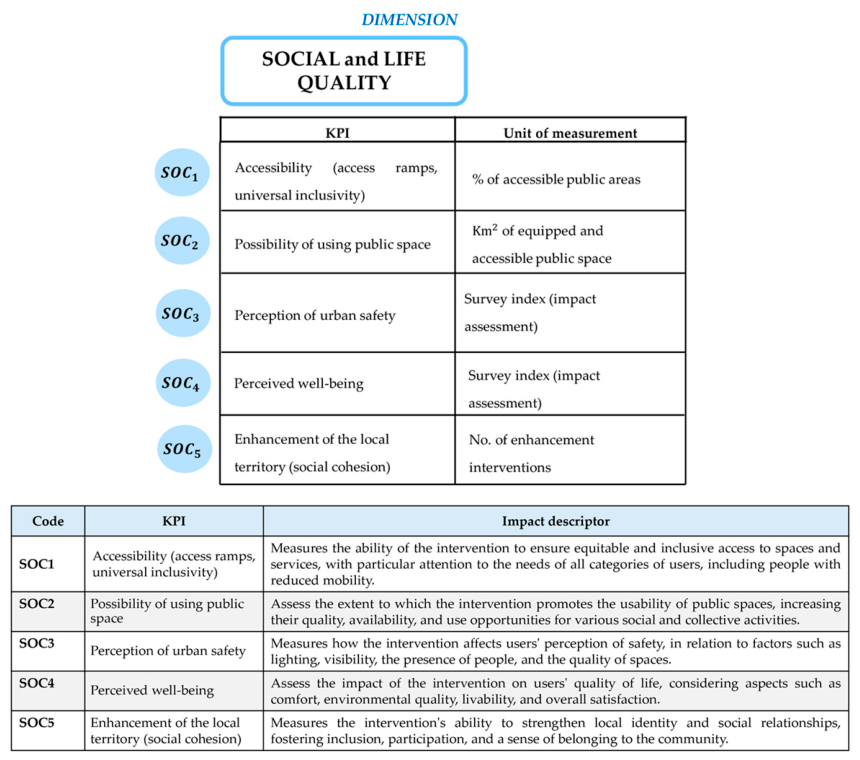
For each dimension, the possible expected impacts attributable to the intervention alternatives were defined. Each impact was assigned an identification code, a key performance indicator and a unit of measurement, in addition to the specific impact descriptors, as illustrated in Figure 3, Figure 4, Figure 5 and Figure 6.

3.3. Preliminary Cost Estimate for the Implementation of the Different Alternative Project Scenarios

Cost–benefit analysis is a fundamental economic evaluation tool, used to support public decision-making, and required for applications for funding from the European Commission [64]. It is essentially based on the systematic comparison between the costs necessary for carrying out an intervention and the expected benefits over its entire life cycle [65]. Although the contribution is primarily oriented towards assessing the expected benefits of different project alternatives, the costs component plays a decisive role in guiding planning choices. As regards the Tram Line Project (EAV hypothesis), since it is the option that has come closest to the possibility of being realised, it presents a detailed project, equipped with all the necessary works. According to what was reported by the technical–economic feasibility study, the summary cost estimate amounts to €209.3 million, or approximately €19 million per kilometre—a plausible cost, considering the standards of other similar national projects. In the case of the Green Urban Stitch, the alternative is at a preliminary strategic stage. For this reason, the estimate of the realisation costs has been developed as a preliminary parametric cost estimate, with a level of approximation consistent with the early phase of the investigation. Some comparable Italian cases were selected, of projects like the one under examination, whose construction costs are known [38].
The data collected are summarised in Table 2.
Considering that the Green Urban Stitch hypothesis involves a development of approximately 15–18 km, a preliminary parametric estimate suggests a likely implementation cost of around €2 million.

4. Results

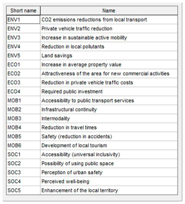
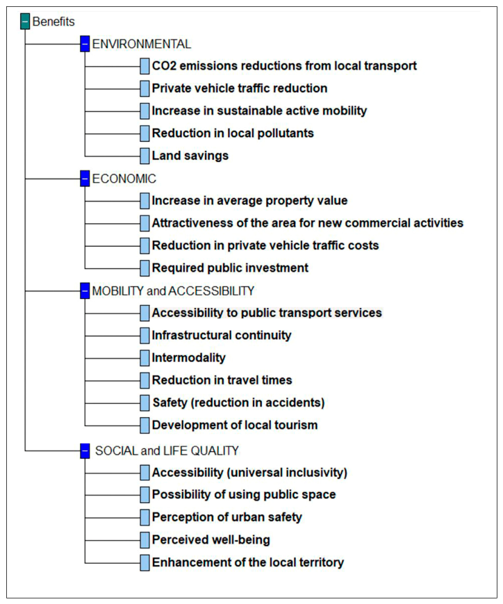
The defined indicators were subsequently processed using M-MACBETH software, version 3.3.0 [12,15,58] to proceed in a structured manner with the comparison of the alternatives through a sequence of methodological and operational phases. In particular, the twenty-one KPIs identified—reported in the summary diagram in Figure 7—were employed in the structuring phase, aimed at defining the MACBETH Value Tree, shown in Figure 8.
For each criterion entered into the software, predefined performance levels have been established according to the expected—or unexpected—impacts and the degree of implementation of the considered indicator. The definition of these performance levels has enabled the standardisation of the assessment process, facilitating the comparison among alternatives and the subsequent attribution of judgments of attractiveness/implementation, performed by the software. In general terms, the performance levels can be simplified as follows:
-
L1—“positive”: indicates a condition in which the indicator is fully included among the objectives of the intervention hypothesis and serves to describe a favourable impact.
-
L2—“neutral”: represents an intermediate condition, characterised by the partial or limited implementation of a given indicator, such that it does not generate particularly significant effects.
-
L3—“unexpected”: describes conditions in which the implementation of a given indicator is not provided for the intervention and therefore produces no impact.
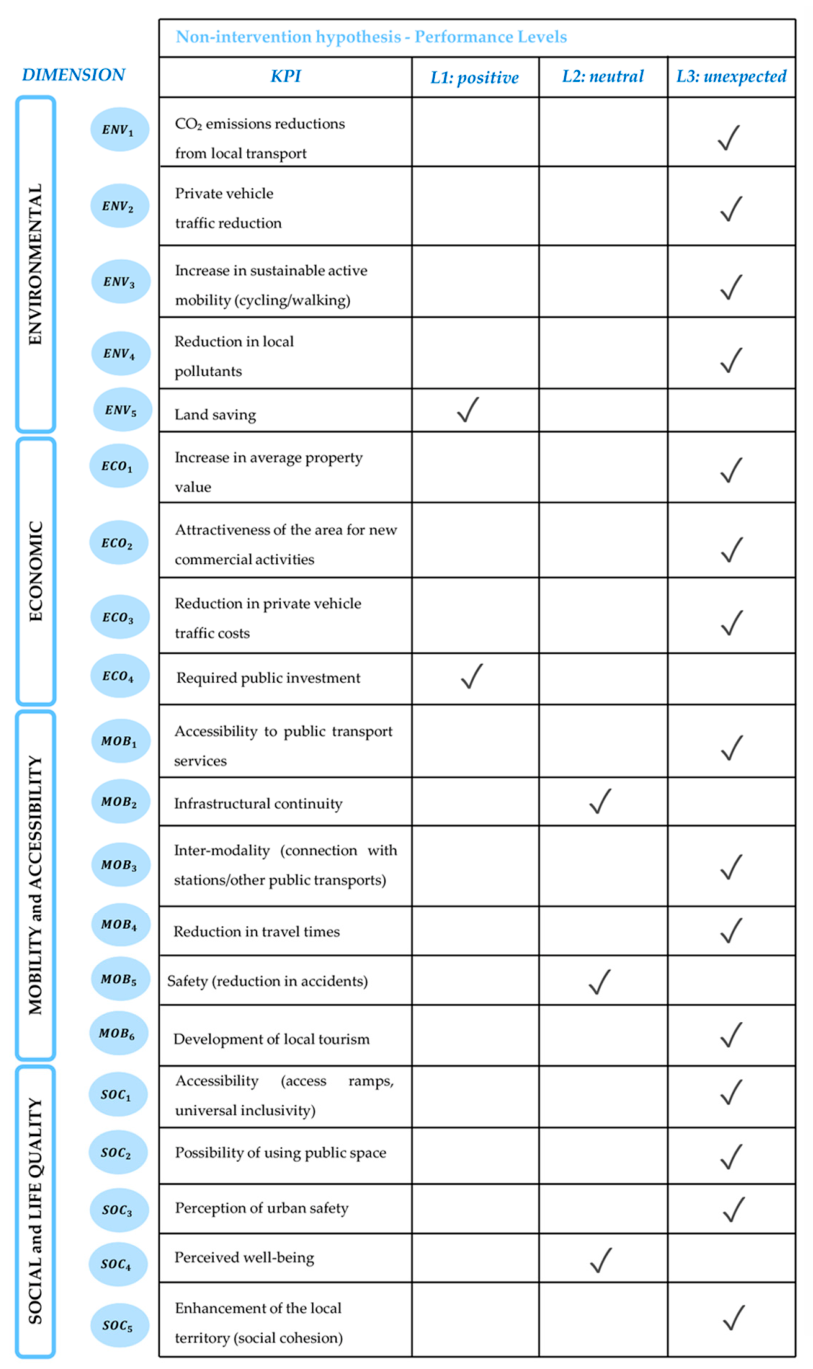
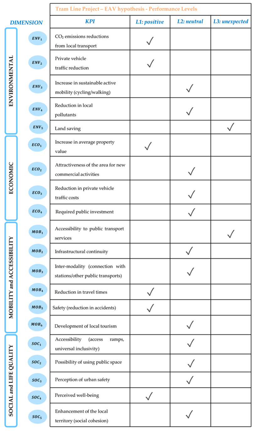
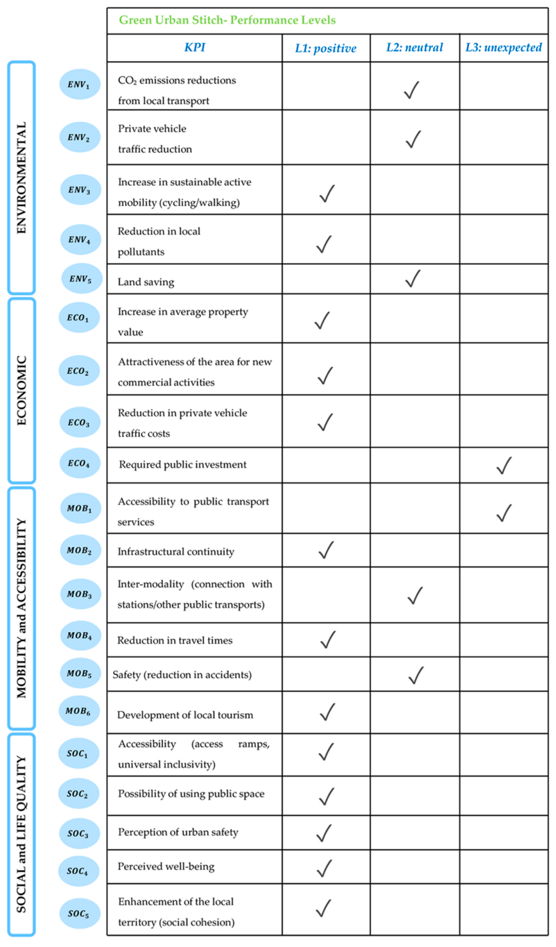
Subsequently, the three project alternatives were entered into the software as distinct intervention “options”. Using the previously defined KPIs, the alternatives were evaluated based on the ability of each option to achieve—or not achieve—the specific performance described by the corresponding level of performance, as illustrated in Figure 9, Figure 10 and Figure 11.
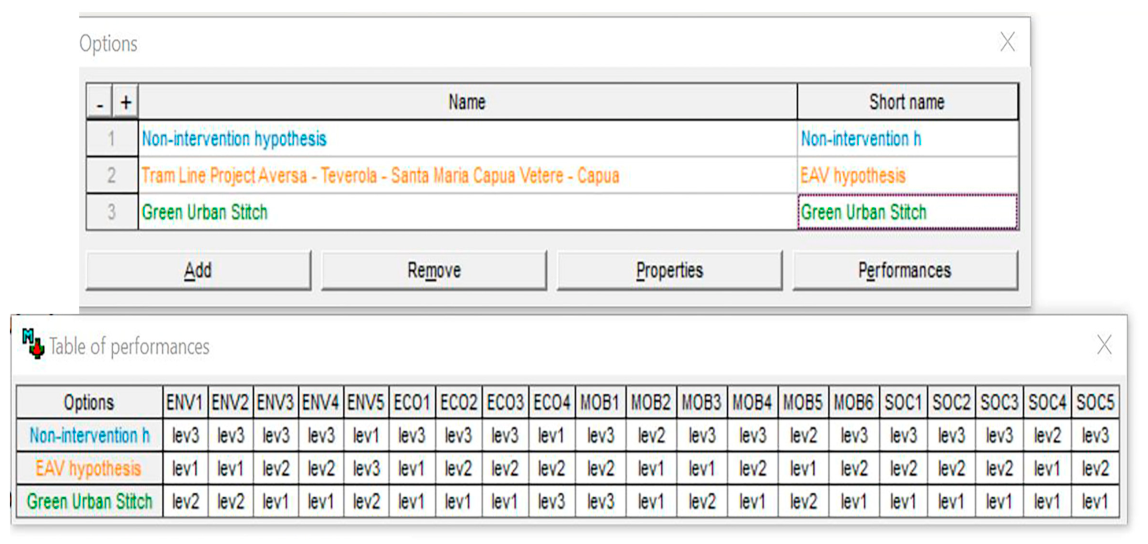
In particular, the judgement assigned to each alternative was derived from assessing the presence, absence or neutrality of the expected performance, as established by the three performance levels set previously. This evaluation made it possible to associate each option with one of the performance levels defined according to all the KPIs assumed, as summarised in Figure 12.
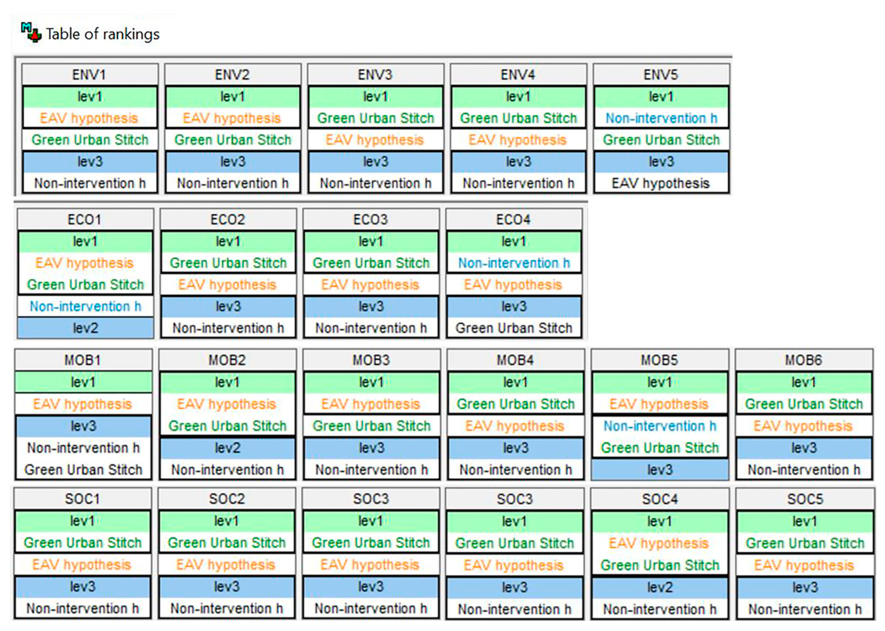
In the subsequent phase, pairwise comparisons among the different project alternatives were carried out. Each intervention hypothesis was compared to the others based on the previously established set of KPIs. For each criterion, each alternative a performance level was assigned to each alternative, according to the presence or absence of the specific impact expected from the intervention. Based on these comparisons, the software generated—for each criterion—a ranking of the three intervention hypotheses, quantifying the degree of attractiveness of each alternative in accordance with the assigned performance levels. The results are presented in Figure 13.
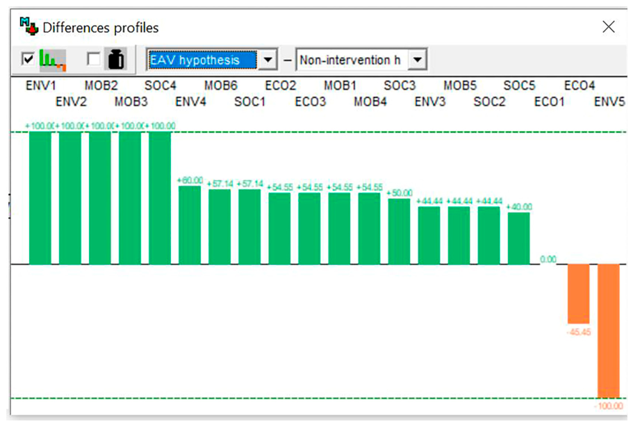
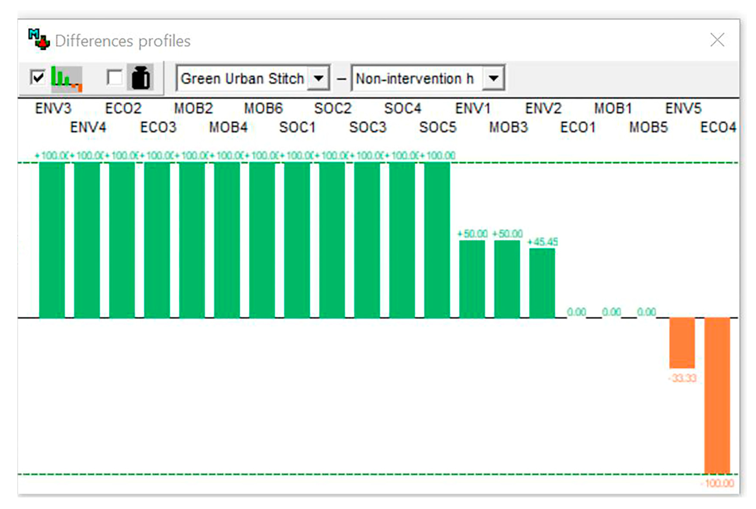
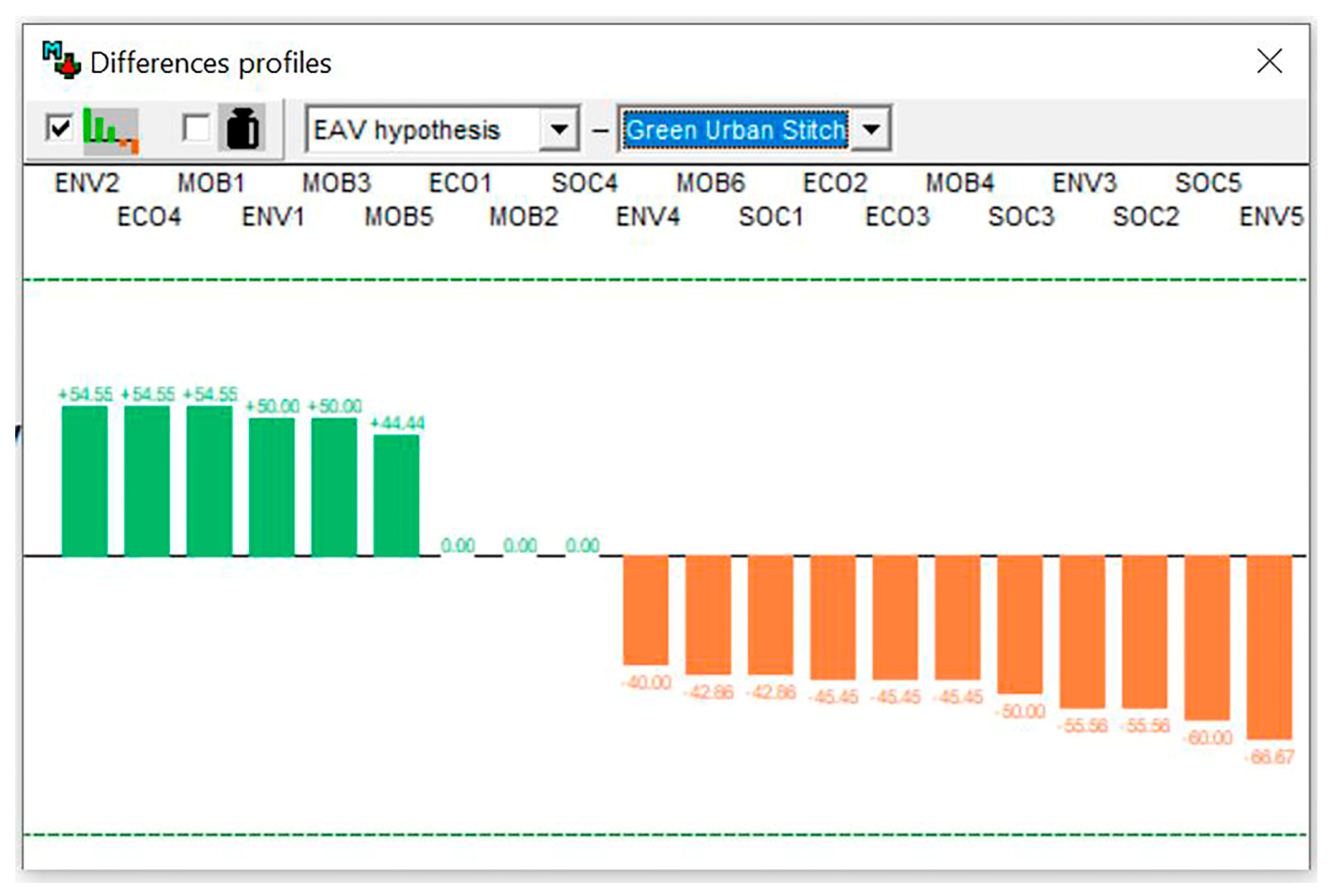
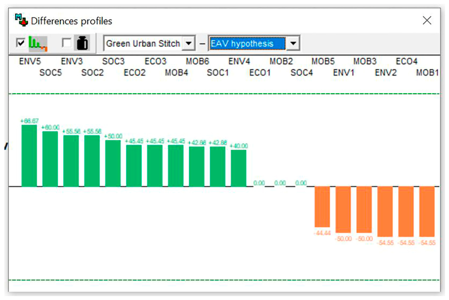
For the purposes of this study, the analysis focuses on the comparison of the performance profiles of the different intervention alternatives, to clearly and immediately highlight their main differences. This comparison made it possible to identify the strengths and weaknesses of each option with respect to the potential impacts considered, emphasising the criteria for which one alternative proves more attractive than the others. The differences among the profiles are graphically illustrated in Figure 14, Figure 15, Figure 16 and Figure 17. Their comparative reading constitutes the basis for the interpretation of the results, which are discussed in the following section.
Regarding implementation costs, it is necessary to emphasise the difference in scale between the intervention hypotheses: the Tram Line Project (EAV hypothesis) would have a structural impact on mobility, unlike the Green Urban Stitch hypothesis, which would have a complementary impact. The cost difference is substantial: the implementation of the Green Urban Stitch hypothesis (€2 million) is estimated to amount to 1% of the costs required for the Tram Line Project (€209.3 million). Moreover, the construction of the tram line would also require significantly longer implementation times and related collateral inconveniences associated with construction site management. On the other hand, the more cost-effective and attractive Green Urban Stitch solution would have a very limited impact on structural mobility, in fact, not constituting an efficient alternative to private vehicle use.

5. Discussion

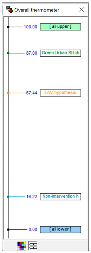
The results of the study highlight how the three alternatives express different paradigms of intervention on the disused former Alifana corridor, with heterogeneous performances across the four dimensions considered. According to the findings derived from the M-MACBETH software analysis, the non-intervention hypothesis displays a weak and residual profile, with benefits limited to the absence of additional land consumption and the lack of public investment in the short term—especially when considering the absence of both ordinary and extraordinary maintenance interventions. However, this option does not produce improvements in terms of accessibility, urban quality, or territorial cohesion, and proves inconsistent with European objectives related to decarbonisation and sustainable mobility. In contrast, the Tram Line Project alternative (EAV hypothesis) achieves the highest evaluations in the mobility and accessibility dimension, due to increased accessibility to public transport, improved infrastructural continuity, and strengthened intermodality. It appears effective in reducing dependence on private vehicles and in enhancing supra-local connections. At the same time, it shows more limited impacts in the environmental and social dimensions, maintaining a predominantly transport-oriented approach, as well as potentially having very high construction costs and timeframes. Finally, the Green Urban Stitch alternative emerges as the most attractive in the overall assessment of benefits, with positive effects across the environmental, economic, and social dimensions, as well as a good attractiveness in terms of economic convenience, according to the parametric estimate of the construction costs. The transformation into a green hinge strengthens active mobility, the quality of public space, and territorial attractiveness, contributing to urban resilience and perceived well-being. Indeed, the overall graph—Figure 18—shows that the Green Urban Stitch hypothesis represents the best option among the alternatives considered. However, it is not capable of structurally resolving the critical issues related to commuting connections, leaving part of the systemic mobility demand unmet.

6. Conclusions

Any intervention hypothesis concerning a disused infrastructure generates a plurality of potential effects, which may assume either a positive connotation—for example, in terms of improving quality of life, increasing access to services, and strengthening territorial cohesion—or a negative one, when considering aspects such as land consumption or the need to invest financial resources in public works. Overlooking this plurality of dimensions would mean adopting a partial perspective, incapable of grasping the real scope of design choices and their medium- to long-term consequences. Considering this, the present contribution has proposed the application of the MACBETH method as a decision-aid tool for the comparative evaluation of three alternatives concerning the former Alifana railway corridor (non-intervention, tramway reactivation, conversion into a greenway). When properly applied, this tool can prove strategic in ex ante decision analysis, useful not only for selecting the most attractive and advantageous option among the different intervention alternatives, but also for supporting urban policy decisions aimed at fostering more accessible, inclusive, and sustainable residential mobility. Based on the findings of the study, the need emerges to prioritise an integrated planning scenario capable of combining collective mobility and green infrastructure, overcoming the dichotomy between “transport infrastructure” and “landscape project.” In this perspective, multi-criteria evaluation does not merely provide a ranking of convenience but constitutes a cognitive tool useful for guiding the definition of public priorities and for clarifying the enabling conditions of the intervention (route continuity, connections with transport hubs, universal accessibility, safety, management, and maintenance).
Within a decision-making process, it is not sufficient to limit the evaluation of design alternatives solely to the economic–financial dimension, since feasibility analysis in terms of costs and benefits—although certainly a fundamental and indispensable step—must be complemented by a broader and more comprehensive reflection in terms of expected benefits. Consequently, it becomes necessary to structure the decision-making process according to a multidimensional approach capable of simultaneously considering the various environmental, social, economic, and territorial impact variables.
Certainly, each of the considered hypotheses presents significant gaps in its strategic framing. The non-intervention hypothesis—interpretable not as a lack of planning, but as a conscious choice to suspend transformation to limit land consumption—has significant critical issues in terms of safety, accessibility and the ability to address existing socio-spatial critical issues, with a high risk of consolidating already present conditions of marginality. The Green Urban Stitch hypothesis, while promoting more sustainable mobility and potentially contributing to the reduction in negative transport-related impacts, still fails to ensure an efficient and accessible public transport system. Conversely, the Tram Line Project (EAV hypothesis)—which is the closest to implementation—focuses its strategy exclusively on mobility yet overlooks a series of complementary benefits that are equally essential for the real socio-spatial rehabilitation of the territorial context. Furthermore, given the high expected implementation cost, it becomes even more necessary to question the actual relevance of the intervention, which, although responding to the demand for the enhancement of the public transport network, cannot significantly contribute to improving overall housing well-being.
In light of these considerations, this contribution does not aim to identify the “winning” alternative, but rather to highlight the strengths of each proposal. The two alternatives—as opposed to the non-intervention scenario—operate on profoundly different scales and through different mechanisms, yet they should not be understood as mutually exclusive. On the contrary, their integration may offer a more effective response to the complexity of contemporary territorial challenges. In this regard, the ongoing transformation of the Jardin des Nations district in Geneva provides an interesting reference [66]. The project demonstrates how large-scale infrastructural interventions, sustainable mobility strategies, public space enhancement, and environmental objectives can be combined within a shared long-term vision. Rather than privileging a single approach, the Geneva experience suggests that the coordination of complementary actions at different levels may generate more coherent and resilient outcomes. Similarly, the two hypotheses explored in this study should not be interpreted as competing alternatives, but rather as complementary and site-specific interventions embedded within a broader and more integrated territorial strategy. Their value lies not in their individual implementation alone, but in their potential to contribute, together with other measures operating at different scales and through different mechanisms, to the construction of a coherent and comprehensive vision for territorial transformation.

Author Contributions

Conceptualisation: C.d.B., F.F., D.M., A.N. and Y.R.; Methodology: A.N., D.M. and Y.R.; Software: Y.R.; Validation: C.d.B., F.F., D.M., A.N. and Y.R.; Formal Analysis: C.d.B., F.F., D.M., A.N. and Y.R.; Resources: C.d.B., F.F., D.M., A.N. and Y.R.; Data Curation: C.d.B., F.F., D.M., A.N. and Y.R.; Writing—Original Draft Preparation: C.d.B., F.F., D.M., A.N. and Y.R.; Writing—Review and Editing: C.d.B., F.F., D.M., A.N. and Y.R.; Supervision: C.d.B. and F.F. All authors have read and agreed to the published version of the manuscript.

Funding

This research received no external funding.

Institutional Review Board Statement

Not applicable.

Informed Consent Statement

Not applicable.

Data Availability Statement

The original contributions presented in this study are included in the article. Further inquiries can be directed to the corresponding author.

Acknowledgments

The use of the M-MACBETH software was made possible through a licence granted to the author within the framework of a broader doctoral research project, in which the software represents an important methodological tool. All the authors would like to thank the CEGIST (Centre for Management Studies) of the Instituto Superior Técnico in Lisbon for providing the licence that enabled the use of the software in the research activity reported in this contribution.

Conflicts of Interest

The authors declare no conflicts of interest.

References

  1. OECD. Infrastructure to 2030: Main Findings and Policy Recommendations; OECD Publishing: Paris, France, 2007; Available online: https://www.oecd.org/content/dam/oecd/en/publications/reports/2006/06/infrastructure-to-2030_g1gh6ab9/9789264023994-en.pdf (accessed on 3 June 2026).
  2. Organisation for Economic Co-operation and Development; World Bank. Infrastructure for a Climate-Resilient Future; OECD Publishing: Paris, France, 2024; Available online: https://www.oecd.org/content/dam/oecd/en/publications/reports/2024/04/infrastructure-for-a-climate-resilient-future_c6c0dc64/a74a45b0-en.pdf (accessed on 3 June 2026).
  3. Dioikitopoulos, E.; Kalyvitis, S. Public capital maintenance and congestion: Long-run growth and fiscal policies. J. Econ. Dyn. Control 2008, 32, 3760–3779. [Google Scholar] [CrossRef]
  4. UN-Habitat. World Cities Report 2020; United Nations: Nairobi, Kenya, 2020; Available online: https://unhabitat.org/sites/default/files/2020/10/wcr_2020_report.pdf (accessed on 3 June 2026).
  5. McCarragher, S.; Acuff, C.; Cowden, C.; DeAnna, E.B. A bibliometric analysis of urban greenway literature: Implications for interdisciplinary research on urban systems. Discov. Cities 2024, 1, 25. [Google Scholar] [CrossRef]
  6. European Commission. Sustainable and Smart Mobility Strategy; European Commission: Brussels, Belgium, 2021. Available online: https://www.europarl.europa.eu/RegData/etudes/BRIE/2021/659455/EPRS_BRI(2021)659455_EN.pdf (accessed on 3 June 2026).
  7. European Investment Bank. Investment Report: Retooling Europe’s Economy; European Investment Bank: Luxembourg, 2018; Available online: https://www.eib.org/files/efs/economic_investment_report_2018_en.pdf (accessed on 3 June 2026).
  8. International Monetary Fund. Public investment for the recovery. In World Economic Outlook: The Great Lockdown; IMF: Washington, DC, USA, 2020; pp. 75–110. Available online: https://www.imf.org/en/-/media/files/publications/weo/2020/april/english/text.pdf (accessed on 3 June 2026).
  9. Vatanparast, E.; Shataee Joibari, S.; Salmanmahiny, A.; Hansen, R. Urban greenway planning: Identifying optimal locations for active travel corridors through individual mobility assessment. Urban For. Urban Green. 2024, 101, 128464. [Google Scholar] [CrossRef]
  10. Steuer, R.E. Multiple Criteria Optimization: Theory, Computation, and Application; Wiley: New York, NY, USA, 1986. [Google Scholar]
  11. Keeney, R.L. Value-Focused Thinking: A Path to Creative Decisionmaking; Harvard University Press: Cambridge, MA, USA, 1992. [Google Scholar]
  12. Bana-e-Costa, C.A. Readings in Multiple Criteria Decision Aid; Springer: Heidelberg, Germany, 1990. [Google Scholar] [CrossRef]
  13. Basbas, S.; Makridakis, C.A. Review of the contribution of multi-criteria analysis to the evaluation process of transportation projects. Int. J. Sustain. Dev. Plan. 2007, 2, 20. [Google Scholar] [CrossRef]
  14. Italian Republic. Legislative Decree 31 March 2023, No. 36. Public Contracts Code; Official Journal: Rome, Italy, 2023; Available online: https://www.codiceappalti.it/Home/Legge/?legge=Italian_Procurement_Code_Decree_36/2023 (accessed on 22 June 2026).
  15. Bana e Costa, C.A. Structuration, Construction et Exploitation d’un Modèle Multicritère d’Aide à la Décision. Ph.D. Thesis, IST, Universidade Técnica de Lisboa, Lisbon, Portugal, 1992. [Google Scholar]
  16. Roy, B. Multicriteria Methodology for Decision Aiding; Springer: Dordrecht, The Netherlands, 1996. [Google Scholar]
  17. Oliveira, M.D.; Mataloto, I.; Kanavos, P. Multi-criteria decision analysis for health technology assessment: Addressing methodological challenges to improve the state of the art. Eur. J. Health Econ. 2019, 20, 891–918. [Google Scholar] [CrossRef] [PubMed]
  18. Cunha, N.; Magalhães, M. (Eds.) Planning Rural Landscapes: Green Infrastructure and Ecosystem Services Nexus, 1st ed.; Routledge: London, UK, 2025. [Google Scholar]
  19. Mardani, A.; Zavadskas, E.K.; Khalifah, Z.; Jusoh, A.; Nor, K. Multiple criteria decision-making techniques in transportation systems—A systematic review of the state of the art literature. Transport 2015, 31, 359–385. [Google Scholar] [CrossRef]
  20. Fattinnanzi, E.; Acampa, G.; Forte, F.; Rocca, F. The overall quality assessment in an architecture project. Valori Valutazioni 2018, 21, 3–14. [Google Scholar]
  21. Forte, F. Appraisal and evaluation in the production of works for the transformation of the contemporary city. In Green Energy and Technology; Springer: Cham, Switzerland, 2017; pp. 129–139. [Google Scholar] [CrossRef]
  22. Banister, D. The sustainable mobility paradigm. Transp. Policy 2008, 15, 73–80. [Google Scholar] [CrossRef]
  23. Wong, P.H.; Kourtit, K.; Nijkamp, P. The teleworking paradox: The geography of residential mobility of workers in pandemic times. Ann. Reg. Sci. 2025, 74, 39. [Google Scholar] [CrossRef]
  24. Battisti, F.; Campo, O.; Forte, F.; Menna, D.; Perdonò, M. Residential mobility: The impact of the real estate market on housing location decisions. Real Estate 2025, 2, 9. [Google Scholar] [CrossRef]
  25. Ahern, J. Greenways as a planning strategy. Landsc. Urban Plan. 1995, 33, 131–155. [Google Scholar] [CrossRef]
  26. Toccolini, A.; Fumagalli, N.; Senes, G. Greenways planning in Italy: The Lambro River Valley Greenways System. Landsc. Urban Plan. 2006, 76, 98–111. [Google Scholar] [CrossRef]
  27. European Environment Agency. The First and Last Mile: The Key to Sustainable Urban Transport; EEA: Copenhagen, Denmark, 2019. [Google Scholar]
  28. Cervero, R.; Kockelman, K. Travel demand and the 3Ds: Density, diversity, and design. Transp. Res. Part D 1997, 2, 199–219. [Google Scholar] [CrossRef]
  29. Peng, J.; Zhao, H.; Liu, Y. Urban ecological corridors construction: A review. Acta Ecol. Sin. 2017, 37, 23–30. [Google Scholar] [CrossRef]
  30. García-Mayor, C.; Martí, P.; Castaño, M.; Bernabeu-Bautista, Á. The unexploited potential of converting rail tracks to greenways: The Spanish Vías Verdes. Sustainability 2020, 12, 881. [Google Scholar] [CrossRef]
  31. Rails-to-Trails Conservancy. Rail-Trails and Safe Communities; American Trails: Washington, DC, USA, 2025. [Google Scholar]
  32. Lindsey, G.; Nguyen, D. Use of greenway trails in Indiana. J. Urban Plan. Dev. 2004, 130, 213–217. [Google Scholar] [CrossRef]
  33. Giles-Corti, B.; Vernez-Moudon, A.; Reis, R.; Turrell, G.; Dannenberg, A.L.; Badland, H.; Foster, S.; Lowe, M.; Sallis, J.F.; Stevenson, M.; et al. City planning and population health: A global challenge. Lancet 2016, 388, 2912–2924. [Google Scholar] [CrossRef] [PubMed]
  34. Sant’Anna, C.G.; Mell, I.; Schenk, L.B.M. (Eds.) Planning with Landscape: Green Infrastructure to Build Climate-Adapted Cities; Springer: Cham, Switzerland, 2023. [Google Scholar]
  35. Atlanta BeltLine Inc. Atlanta BeltLine Annual Report; Atlanta BeltLine Inc.: Atlanta, GA, USA, 2019; Available online: https://beltline.org/learn/progress-planning/research-reports/ (accessed on 3 June 2026).
  36. City of Chicago. Bloomingdale Trail/The 606 Reports. 2015–2018. Available online: https://aiph.org/green-city/guidelines/case-studies/chicago-606/ (accessed on 3 June 2026).
  37. Seoul Metropolitan Government. Cheonggyecheon Restoration Project White Paper; Seoul Metropolitan Goverment: Seoul, Republic of Korea, 2006. Available online: https://seoulsolution.kr/sites/default/files/poicy/%5BEN%5DCheong%20Gye%20Cheon%20Restoration%20Project.pdf (accessed on 3 June 2026).
  38. Maggiorotti, I. Atlas of Greenways on Railway Lines: From Disuse to Reuse; RFI: Rome, Italy, 2022; Available online: https://www.rfi.it/content/dam/rfi/news-e-media/pubblicazioni/atlante-greenways-2022/RFI%20ATLANTE%203%20GREENWAYS%202022%2006_12%20b8%20WEB%20D.pdf (accessed on 3 June 2026).
  39. Van Oorschot, J.; Slootweg, M.; Remme, R.P.; Sprecher, B.; van der Voet, E. Optimizing green and Gray infrastructure planning for sustainable urban development. npj Urban Sustain. 2024, 4, 41. [Google Scholar] [CrossRef]
  40. Losco, S.; De Biase, C.; Napolitano, A.; Redouane, Z. Sustainable landscape transformations along the former Alifana railway line for cultural and environmental integration. In World Heritage and Food to Feed. Le Vie dei Mercanti. XXIII International Forum; Gangemi Editore: Rome, Italy, 2025; Volume 17, Available online: https://iris.unicampania.it/handle/11591/566744 (accessed on 22 June 2026).
  41. Nanu, A. La Nuova Alifana: Un Progetto Infrastrutturale di Trasporto su Ferro e Riqualificazione Urbana; Gangemi Editore: Rome, Italy, 2007. [Google Scholar]
  42. Municipality of Capua. Municipal Urban Plan Report; Municipality of Capua: Capua, Italy, 2023; pp. 46–87. Available online: https://servizi.comune.capua.ce.it/openweb/trasparenza/pagina.php?id=69 (accessed on 3 June 2026).
  43. Municipality of Santa Maria Capua Vetere. Municipal Urban Development Plan Report; Municipality of Santa Maria Capua Vetere: Santa Maria Capua Vetere, Italy, 2023; pp. 201–203. Available online: https://www.santamariacapuavetere.eu/ (accessed on 3 June 2026).
  44. Municipality of Teverola. Municipal Urban Development Plan Report; Municipality of Teverola: Teverola, Italy, 2013; Available online: https://www.halleyweb.com/c061092/zf/index.php/trasparenza/index/index/categoria/187/page/1 (accessed on 3 June 2026).
  45. Municipality of Aversa. Draft Municipal Urban Development Plan; Municipality of Aversa: Aversa, Italy, 2020; Available online: https://comune.aversa.ce.it/documento_pubblico/piano-regolatore-generale/ (accessed on 3 June 2026).
  46. De Biase, C.; Pellicano, A. La provincia di Caserta: Proposte per un piano strategico di sviluppo turistico. In Atti della XXXII Conferenza Scientifica Annuale AISRe; AISRe: Turin, Italy, 2011; pp. 1–30. [Google Scholar]
  47. Diaby, V.; Campbell, K.; Goeree, R. Multi-criteria decision analysis (MCDA) in health care: A bibliometric analysis. Oper. Res. Health Care 2013, 2, 20–24. [Google Scholar] [CrossRef]
  48. Bottero, M.; D’Alpaos, C.; Oppio, A. Multicriteria evaluation of urban regeneration processes: An application of PROMETHEE method in Northern Italy. Adv. Oper. Res. 2018, 2018, 9276075. [Google Scholar] [CrossRef]
  49. Abi-Zeid, I.; Cerutti, J. Multi-criteria decision aiding for built heritage value assessment: Model and application in Québec City, Canada. Ann. Oper. Res. 2025, 353, 77–92. [Google Scholar] [CrossRef]
  50. Perez, J.C.; Carrillo, M.H.; Montoya-Torres, J.R. Multicriteria approaches for urban passenger transport systems: A literature review. Ann. Oper. Res. 2016, 226, 69–87. [Google Scholar] [CrossRef]
  51. Shoshany, M.; Shapira, A.; Nir-Goldenberg, S.; De Paola, P. Progression of greenway corridors through conflict: Cellular automata simulation and AHP evaluation. Environ. Model. Assess. 2023, 28, 519–533. [Google Scholar] [CrossRef]
  52. Balta, M.Ö.; Yenil, H.Ü. Multi criteria decision making methods for urban greenway: The case of Aksaray, Turkey. Land Use Policy 2019, 89, 104224. [Google Scholar] [CrossRef]
  53. Della Spina, L.; Lanteri, C. A collaborative multi-criteria decision-making framework for the adaptive reuse design of disused railways. Land 2024, 13, 851. [Google Scholar] [CrossRef]
  54. Gregory, R.; Failing, L.; Harstone, M.; Long, G.; Mcdaniels, T.; Ohlson, D. Structured Decision Making: A Practical Guide to Environmental Management Choices; John Wiley & Sons: Chichester, UK, 2012; Available online: https://content.e-bookshelf.de/media/reading/L-601220-07b5b50787.pdf (accessed on 22 June 2026).
  55. Bana e Costa, C.A.; Oliveira, M.D.; Rodrigues, T.C.; Vieira, A.C.L. Desirability–durability group judgment framework for the collaborative multicriteria evaluation of public policies. Int. Trans. Oper. Res. 2023, 30, 3654–3686. [Google Scholar] [CrossRef]
  56. Bana e Costa, C.A.; Vansnick, J.-C. MACBETH—An interactive path towards the construction of cardinal value functions. Int. Trans. Oper. Res. 1994, 1, 489–500. [Google Scholar] [CrossRef]
  57. Ferreira, F.A.F.; Santos, S.P. Two decades on the MACBETH approach: A bibliometric analysis. Ann. Oper. Res. 2021, 296, 901–925. [Google Scholar] [CrossRef]
  58. Bana e Costa, C.A.; Beinat, E. Model-Structuring in Public Decision-Aiding; London School of Economics and Political Science: London, UK, 2005. [Google Scholar]
  59. Bana e Costa, C.A.; Chagas, M.P. A career choice problem: An example of how to use MACBETH to build a quantitative value model based on qualitative value judgments. Eur. J. Oper. Res. 2004, 153, 323–331. [Google Scholar] [CrossRef]
  60. Bana e Costa, C.A.; Oliveira, M.D. A multi-criteria decision analysis model for faculty evaluation. Omega 2011, 40, 424–436. [Google Scholar] [CrossRef]
  61. Bana e Costa, C.A.; Vansnick, J.-C. The MACBETH approach: Basic ideas, software, and an application. In Advances in Decision Analysis; Meskens, N., Roubens, M., Eds.; Springer: Dordrecht, The Netherlands, 1999; pp. 131–157. [Google Scholar] [CrossRef]
  62. Bana e Costa, C.A.; De Corte, J.-M.; Vansnick, J.-C. MACBETH. Int. J. Inf. Technol. Decis. Mak. 2012, 11, 359–387. [Google Scholar] [CrossRef]
  63. Bana e Costa, C.A.; Meza, L.A.; Oliveira, M.D. O método MACBETH e aplicação no Brasil. Engevista 2013, 15, 94–107. [Google Scholar] [CrossRef]
  64. European Commission. Guide to Cost-Benefit Analysis of Investment Projects. Economic appraisal tool for Cohesion Policy 2014–2020. 2021. Available online: https://ec.europa.eu/regional_policy/sources/studies/cba_guide.pdf (accessed on 3 June 2026).
  65. Boardman, A.E.; Greenberg, D.H.; Vining, A.R.; Weimer, D.L. Cost-Benefit Analysis Concepts and Practice, 4th ed.; Pearson Education, Inc.: Saddle River, NJ, USA, 2011; p. 539. [Google Scholar]
  66. United Nations. Nations Towards a Sustainable Neighborhood, UN Today, 2023. Available online: https://untoday.org/nations-towards-a-sustainable-neighborhood/ (accessed on 3 June 2026).
Figure 1. The route of the old Alifana line, set within the current territorial context. Source: author’s elaboration.
Urbansci 10 00354 g001
Figure 2. Masterplan of the Green Urban Stitch Project. Source: authors’ elaboration.
Urbansci 10 00354 g002
Figure 3. Overview of the KPIs and units of measurement that can be used to assess potential environmental impacts, followed by KPIs’ impact descriptors. Source: author’s elaboration.
Urbansci 10 00354 g003
Figure 4. Overview of the KPIs and units of measurement that can be used to assess potential economic impacts, followed by KPIs’ impact descriptors. Source: author’s elaboration.
Urbansci 10 00354 g004
Figure 5. Overview of the KPIs and units of measurement that can be used to assess potential mobility and accessibility impacts, followed by KPIs’ impact descriptors. Source: author’s elaboration.
Urbansci 10 00354 g005
Figure 6. Overview of the KPIs and units of measurement that can be used to assess potential social and life quality impacts, followed by KPIs’ impact descriptors. Source: author’s elaboration.
Urbansci 10 00354 g006
Figure 7. KPI list. Source: author’s elaboration using M-MACBETH software.
Urbansci 10 00354 g007
Figure 8. MACBETH Value tree. Source: author’s elaboration using M-MACBETH software.
Urbansci 10 00354 g008
Figure 9. Operational stage—assessment of the project alternative: non-intervention hypothesis. Evaluation of the option according to the specific performance levels for each indicator assumed. The checkmarks indicate the expected level of performance for each criterion. Source: author’s elaboration.
Urbansci 10 00354 g009
Figure 10. Operational stage—assessment of the project alternative: Tram Line Project—EAV hypothesis. Evaluation of the option according to the specific performance levels for each indicator assumed. The checkmarks indicate the expected level of performance for each criterion. Source: author’s elaboration.
Urbansci 10 00354 g010
Figure 11. Operational stage—assessment of the project alternative: Green Urban Stitch hypothesis. Evaluation of the option according to the specific performance levels for each indicator assumed. The checkmarks indicate the expected level of performance for each criterion. Source: author’s elaboration.
Urbansci 10 00354 g011
Figure 12. Options and summative “Table of Performances”. Source: author’s elaboration using M-MACBETH software.
Urbansci 10 00354 g012
Figure 13. Table of rankings. Source: author’s elaboration using M-MACBETH software.
Urbansci 10 00354 g013
Figure 14. Differences profiles. With respect to the Tram Line Project (EAV hypothesis): positive impacts attributable to the intervention are shown in green, while negative impacts are shown in orange—compared to the non-intervention hypothesis. Source: author’s elaboration using M-MACBETH software.
Urbansci 10 00354 g014
Figure 15. Differences profiles. With respect to the Green Urban Stitch hypothesis: positive impacts attributable to the intervention are shown in green, while negative impacts are shown in orange—compared to the non-intervention hypothesis. Source: author’s elaboration using M-MACBETH software.
Urbansci 10 00354 g015
Figure 16. Differences profiles. With respect to the Tram Line Project (EAV hypothesis): positive impacts attributable to the intervention are shown in green, while negative impacts are shown in orange—compared to the Green Urban Stitch hypothesis. Source: author’s elaboration using M-MACBETH software.
Urbansci 10 00354 g016
Figure 17. Differences profiles. With respect to the Green Urban Stitch hypothesis: positive impacts attributable to the intervention are shown in green, while negative impacts are shown in orange—compared to the Tram Line Project (EAV hypothesis). Source: author’s elaboration using M-MACBETH software.
Urbansci 10 00354 g017
Figure 18. Overall ranking. Source: author’s elaboration using M-MACBETH software.
Urbansci 10 00354 g018
Table 1. Synthesis of selected policy objectives, measurable through quantitative and qualitative indicators. Source: author’s elaboration.
Policy ObjectivesKPIUnit of Measurement
Transport decarbonisationDecrease in emissionsUp to 90% reduction in climate-changing emissions by 2050
Increase in zero-emission vehiclesZero-emission vehicles on the road+30 million zero-emission cars on EU roads by 2030
Zero-emission heavy vehicles and busesAlmost 100% of trucks and buses zero-emission by 2050
Low-emission collective mobilityLow-emission collective travelPlanned journeys < 500 km to be carbon neutral by 2030
Equity and social accessibility to mobilityIntegration of mobility services/facilitation of public transport% of population with access to sustainable public transport services
Mobility safety and resilienceReduction in road accident risks% of road accidents
Table 2. Comparable reference data for the preliminary parametric cost estimate of the Green Urban Stitch hypothesis. Source: author’s elaboration.
Reference ProjectDimensionPlanned Investment€/km
Greenway Moggio–Tarvisio Centrale Cicloviaa alpe Adria (Friuli-Venezia Giulia region)49.8 km€6.6 million + €670,000 for geostatic protections130,000 €/km
Greenway Montebelluna–Nervesa della Battaglia (Veneto region)15.4 km€400,00026,000 €/km
Greenway Poggibonsi–S. Gimignano–Colle val D’elsa (Tuscany region)6.9 km€640,00092,753 €/km
Greenway Ortona–Vasto (Abruzzo region)43 km€8 million195,000 €/km
Greenway Paladina–Piazza Brembana (Lombardy region)31.5 km€4.8 million152,380 €/km
Total arithmetic average119,427 €/km
Disclaimer/Publisher’s Note: The statements, opinions and data contained in all publications are solely those of the individual author(s) and contributor(s) and not of MDPI and/or the editor(s). MDPI and/or the editor(s) disclaim responsibility for any injury to people or property resulting from any ideas, methods, instructions or products referred to in the content.