1. Introduction
Courtyards as elements of urban green infrastructure: Urban green infrastructure refers to networks of natural and semi-natural areas that support ecological processes and ecosystem services across multiple spatial scales, from individual lots to metropolitan systems [
1].
Urbanization and densification, however, tend to fragment these networks into heterogeneous habitat patches of varying size and quality. As a result, urban open spaces form multi-scalar spatial patterns shaped by ecological, social, and planning processes. Understanding urban ecological dynamics therefore requires explicit attention to spatial scale and the hierarchical organization of habitat structures [
2]. Planning strategies play a critical role in shaping these patterns, influencing both the distribution and continuity of urban green systems.
The concept of complementary ecological land uses, introduced by Colding (2007), challenges the traditional public–private distinction and encourages planners to view all urban spaces as part of a unified ecological system [
3]. From this perspective, residential yards can be understood as ecologically relevant components of the urban landscape, with the potential to enhance spatial connectivity and expand everyday access to vegetated space. Empirical evidence supports this view: yards account for an average of 23% of urban areas in Great Britain [
4] and up to 36% in Dunedin, New Zealand [
5]. In addition, studies indicate that these residential areas often contain a large share of the urban vegetation [
6,
7]. Despite their spatial extent and potential ecological relevance, these spaces are rarely analyzed as structured spatial components of urban ecological systems or as contributors to urban biodiversity.
Residential yards also play an important spatial role within urban ecological networks. Private gardens and shared residential yards can function as ecological stepping stones, linking larger green areas and supporting species movement across the urban matrix [
6,
8]. However, most research has focused either on privately owned gardens and household-level management practices or on large-scale urban green infrastructure. Less attention has been given to the morphological and spatial conditions that shape biodiversity potential in shared residential yards, particularly in dense multi-family housing environments where collective housing is a dominant urban form.
In multi-family housing, shared ownership structures influence how residential yards are managed, often leading to variability in maintenance intensity and intervention. These governance dynamics have ecological implications. Maintenance regimes influence vegetation structure, soil continuity, disturbance patterns, and the establishment of spontaneous vegetation, thereby shaping biodiversity outcomes in residential environments [
9,
10].
Recent scholarship has highlighted that certain ecological elements located on private urban land, such as trees, generate non-excludable benefits and can therefore be understood as forms of public goods [
11]. Building on this perspective, the present study shifts the focus from individual ecological elements to the spatial conditions that enable vegetation. It introduces Potentially Vegetated Area (PVA) as an operational proxy for the spatial capacity of residential landscapes to support vegetation. PVA captures the availability of potentially vegetated substrate, but does not account for habitat quality, species composition, or direct biodiversity outcomes.
Urban morphology: Integrating urban morphology and typological analysis with contemporary research on urban biodiversity offers a promising but still underdeveloped interdisciplinary framework [
12,
13]. A limited number of studies have attempted to bridge these fields by examining how urban form influences ecological processes.
Marcus (2007) and Ståhle (2010) explored the relationships between urban spatial structure and environmental performance, while Marcus and Colding (2014) discussed strategies for guiding urban development toward more sustainable trajectories [
14,
15,
16]. More recently, Lepratto and Zanotto (2024) highlighted the potential of morphological typologies as a planning tool for biodiversity-oriented urban transformation [
17].
Urban morphological research often relies on typological analysis to simplify and classify complex spatial patterns [
13,
18]. Within this tradition, the lot is considered one of the fundamental elements of urban form and serves as an organizing basis for buildings, open spaces, and streets [
13,
19]. From an ecological perspective, building and yard typologies are not merely descriptive architectural categories but recurring spatial configurations that structure key determinants of biodiversity, including soil continuity, the extent and distribution of potentially vegetated areas, and typical maintenance regimes. As such, they provide a scalable analytical link between urban form and ecological processes [
6,
20].
Typological analysis and its links to urban biodiversity research: Urban ecological processes operate across multiple spatial scales, from individual lots to metropolitan regions, and biodiversity patterns reflect this multiscalar structure. Empirical studies show that yard-level characteristics influence species’ richness, while neighborhood-scale vegetation adds explanatory power [
21]. In parallel, urban morphology research highlights multiscale frameworks that identify recurring spatial patterns across buildings, blocks, and neighborhoods [
22,
23]. Morphological analysis can thus be used to examine how densification reshapes the distribution, fragmentation, and continuity of open space. Aggregating residential lots into clusters enables the interpretation of localized ecological attributes, such as vegetation and PVA, within broader urban patterns. In this study, this approach is used to estimate the distribution of vegetated potential at the metropolitan scale based on typological characteristics.
Because lot structure and building types are associated with specific development periods, typological analysis also provides a basis for examining temporal change, including redevelopment and renewal. Many residential buildings constructed in Israel between the 1950s and 1970s exhibit structural vulnerability, underpinning contemporary renewal frameworks such as TAMA 38, which target pre-1980 buildings. As these buildings reach 50–60 years of age, economic obsolescence and development pressures drive renewal cycles shaped by structural aging and regulatory thresholds.
Urban environments are dynamic systems in which spatial structures evolve through construction, adaptation, and renewal [
12,
24]. Typologies therefore function as both spatial and temporal units, reflecting not only built form but also shared life cycles. When buildings within a fabric were constructed in similar periods, redevelopment pressures may converge, producing cumulative transformations at the neighborhood scale.
These dynamics have important ecological implications. Vegetated spaces in residential fabrics may remain stable for long periods but become vulnerable under intensified renewal. When typologically and chronologically similar clusters undergo redevelopment simultaneously, parcel-level changes can accumulate into large-scale shifts in urban vegetation. Residential yards thus represent distributed ecological resources whose persistence depends on the temporal dynamics of urban transformation.
Recent field-based research in Givatayim showed that shared residential yards can function as ecologically meaningful components of the urban landscape, with biodiversity potential shaped by spatial and maintenance characteristics [
25]. In that study, the size of the potentially vegetated area was positively associated with wild plant species richness and diversity, and non-synanthropic species were strongly associated with large block typologies with substantial PVA and lower maintenance intensity [
25]. Building on these findings, the present study treats vegetated potential as a spatial precondition associated with ecological diversity and species richness, while acknowledging that PVA does not directly measure biodiversity, habitat quality, or species composition. The study examines how morphological features relate to estimated vegetated potential and how these distributed resources may be affected by urban renewal at the metropolitan scale. By classifying residential environments into typologies and linking them to PVA estimates, the study maps the likely distribution of vegetated potential across dense urban areas. Rather than providing a direct metropolitan measurement of ecological capacity, this study proposes a typology-based framework for extending localized ecological observations to a broader urban context.
2. Methodology
This study was conducted in two phases. The first phase consisted of a field-based analysis of shared residential yards in Givatayim [
25], which established the typological framework and PVA values based on direct field measurements. The second phase extended this analysis to five additional cities in the Tel Aviv metropolitan region by applying the typological framework to a broader metropolitan context.
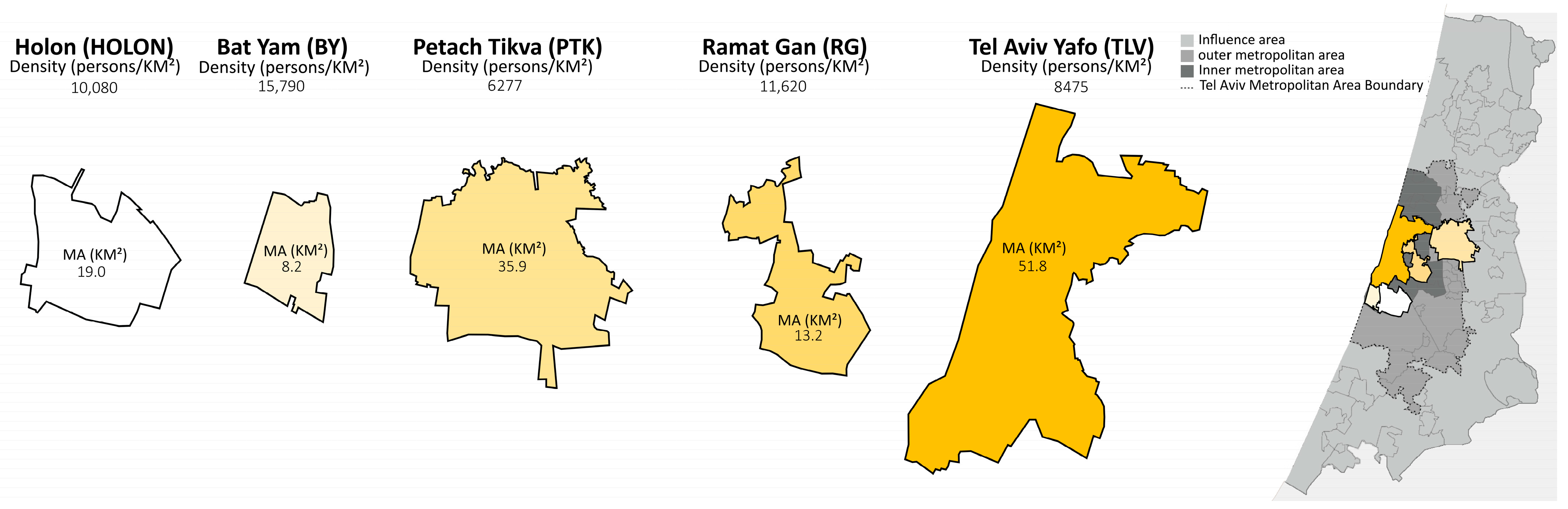
These five cities represent distinct combinations of urban form and spatial structure: Petah Tikva, Tel Aviv-Yafo, Ramat Gan, Bat Yam, and Holon. Together with Givatayim, they capture a broad spectrum of residential morphologies in the metropolitan area, from early low-rise blocks to recent high-rise tower complexes. Although located within the same metropolitan system, the five cities differ substantially in municipal size, population, built density, urban form, and historical development trajectories. The study area was deliberately limited to contiguous municipalities within the core of the Tel Aviv-Yafo metropolitan area, excluding peripheral and suburban jurisdictions to maintain comparability in density regimes, development pressures, and planning frameworks (see
Figure 1).
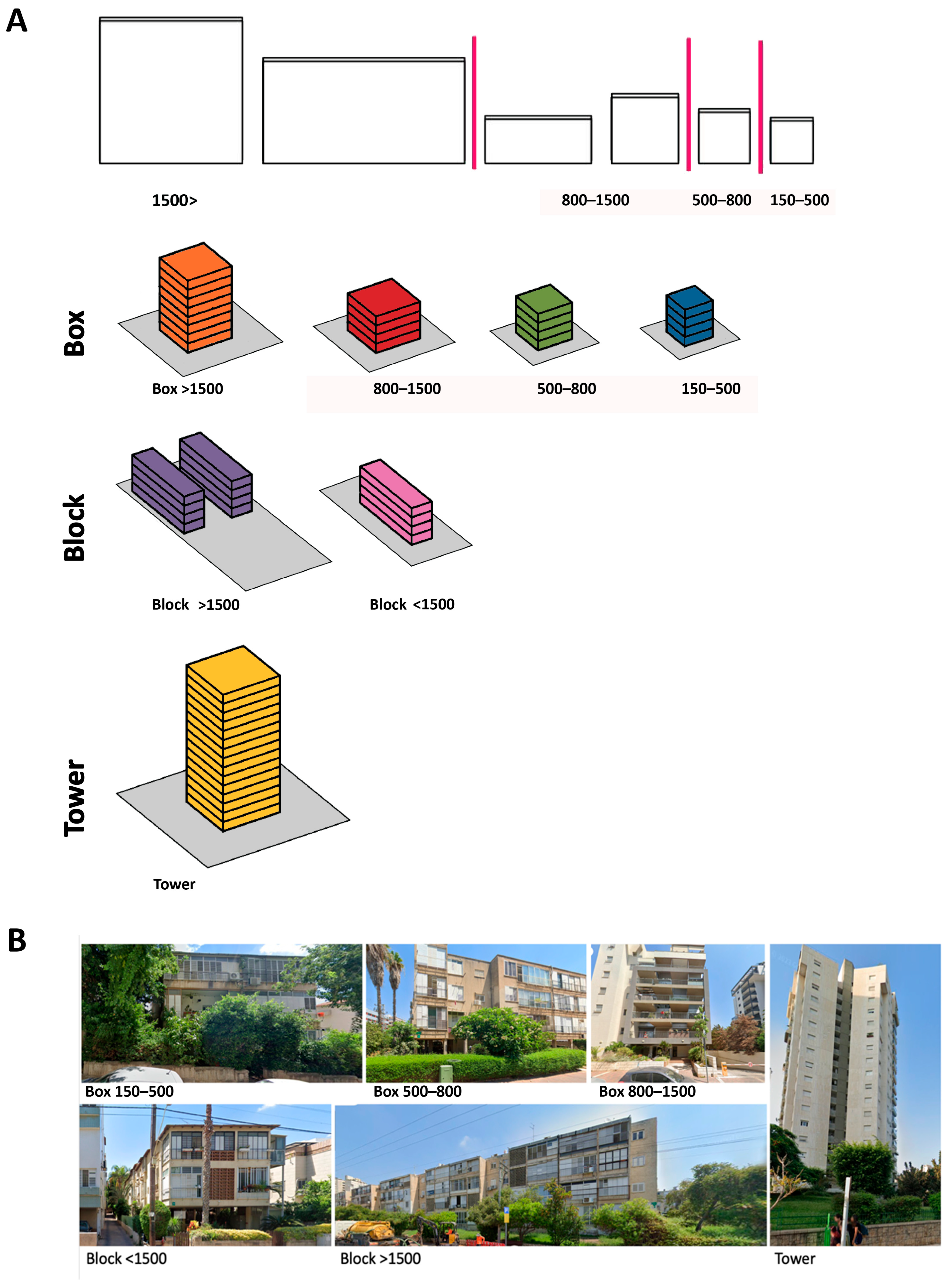
Typology Classification: The metropolitan analysis builds on six shared residential typologies previously identified through fieldwork in Givatayim and defined by combinations of building type (box, block, or tower) and lot-size categories, as follows: Box 150–500, Box 500–800, Box 800–1500, Block < 1500, Block > 1500, and Tower [
25]. These typologies served as the initial analytical framework for metropolitan-scale testing. Classification was carried out using Geographic Information Systems (GIS), which enabled geospatial mapping and morphological analysis of shared residential configurations across the selected case studies.
During this process, an additional typology, Box > 1500 m
2, was identified. Although this category was not present in Givatayim, it appeared consistently in the other surveyed cities (
Figure 2). The typological framework was therefore expanded from six to seven categories, which together captured nearly all shared residential areas within the study area. To further characterize the morphological distinction between typologies, building dimensions were estimated using the minimum bounding rectangle enclosing each building footprint. The shorter side of this rectangle was recorded as width and the longer side as length. These measurements are used as indicative descriptors of building form rather than as exact footprint areas.
Following this revision, all residential areas in the selected cities were mapped according to the seven-category typological framework. Buildings that did not conform to any of the defined categories were excluded from the dataset and classified as “Other.” This category represents only a small proportion of the total residential stock across the five cities, ranging from 0.8% to 2.5%, with a mean value of 1.72%. The same exclusion criterion was applied to single-ownership yards in order to maintain consistency with the selection parameters established in the initial Givatayim field study [
25].
Chronological Development Analysis: Given that buildings in Israel often face increased redevelopment pressure after roughly 50–60 years, identifying areas with high renewal potential required a chronological assessment of the seven typologies in each of the five cities. A sample-based analysis of construction years was therefore conducted for each typology to detect patterns of aging and identify those with relatively high renewal potential. For this purpose, ten buildings per typology were randomly sampled in each city as an exploratory sample, using GIS software (QGIS 4.0), and their construction dates were determined through the examination of records in the relevant municipal building files.
Lots deemed unsuitable for analysis, owing to commercial frontages, missing archival records, or similar deficiencies, were excluded and replaced through random resampling. In Holon, reliable archival data for dating residential typologies were unavailable; thus, all chronology-dependent analyses were conducted for the four documented cities only.
Typologies with a median construction year earlier than 1980 were therefore classified as having high potential for renewal, as an operational threshold reflecting the commonly observed 50–60 year renewal cycle in the Israeli context, rather than as a fixed or universal cutoff.
Clusters of identical typologies were delineated based on either shared lot boundaries or a maximum inter-lot distance of 15 m, a criterion intended to reduce artificial fragmentation associated with the street network and street width. Typology grouping was performed using the City Clustering Algorithm (CCA) developed by Rozenfeld [
26].
Estimation of PVA at the metropolitan scale: A comparative analysis was conducted to evaluate the relative share of estimated PVA associated with each typology across the five cities. PVA values outside Givatayim were not directly measured and are therefore interpreted as typology-based estimates rather than observed ecological variables. This analysis was based on the detailed field survey of 56 residential lots in Givatayim and was supplemented by additional sampling for the seventh typology. For this newly identified typology, the mean PVA was estimated from 10 randomly selected lots, two from each of the five cities. This sample is treated as an exploratory approximation intended to provide an indicative PVA ratio for typology-based estimation, rather than as a statistically representative dataset. Sample sizes are consistent with exploratory ecological field studies where comparable plot-level measurements are used to derive indicative spatial patterns. For each cluster exceeding 10,000 m2, PVA was estimated using typology-specific PVA ratios calibrated in the Givatayim field study and applied as metropolitan estimates. In practice, the relative PVA ratio derived for each typology in Givatayim was applied to the corresponding parcels within each cluster, and the resulting values were summed to generate a cluster-level estimate.
Spatial scale and clustering: From an ecological perspective, the selected threshold corresponds to an intermediate spatial scale at which vegetation patterns can be interpreted as part of a patch mosaic rather than as isolated parcels. Urban ecological research has consistently shown that processes such as species movement, habitat availability, and connectivity operate across spatial extents of tens to hundreds of meters [
8,
20,
27]. Accordingly, a 10,000 m
2 unit (approximately 100 m× 100 m) represents an operational scale at which spatial ecological patterns become analytically meaningful, while smaller units primarily capture localized variability.
In the Israeli context, this ecological scale aligns with the spatial extent at which area-based urban renewal processes typically operate, where multiple adjacent parcels are consolidated into development units, often spanning approximately 5000–10,000 m2. The selected threshold therefore captures both ecologically meaningful spatial patterns and the scale at which renewal processes, and their cumulative ecological implications, are most likely to occur.
Identification of renewal exposure: Clusters composed predominantly of older typologies with relatively high potential exposure to renewal were identified. Based on this assessment, each city was categorized into zones with relatively high potential exposure to renewal in the coming decades and zones with lower potential exposure.
In summary, the procedure involved mapping typological clusters, identifying areas with higher potential exposure to renewal, and estimating the spatial distribution of vegetated potential across the metropolitan residential fabric based on typology-specific PVA coefficients derived from Givatayim.
3. Results
The results show that the seven-typology framework captures the vast majority of shared residential areas across the study area and provides a consistent basis for metropolitan comparison. The following analyses examine three main dimensions of variation across cities: (1) the extent of the estimated PVA associated with each typology, (2) the relative prevalence of typologies within the residential fabric, and (3) the chronological order in which these typologies emerged during urban development. However, typologies differ not only in prevalence and their associated PVA, but also in their associated maintenance regimes and ecological implications. Recently developed Tower typologies represent a distinct configuration characterized by intensive management practices. Together, these analyses illustrate how different urban growth trajectories are associated with differentiated patterns in the distribution of estimated vegetated potential within the metropolitan residential fabric.
3.1. Prevalence of Typologies Across Cities
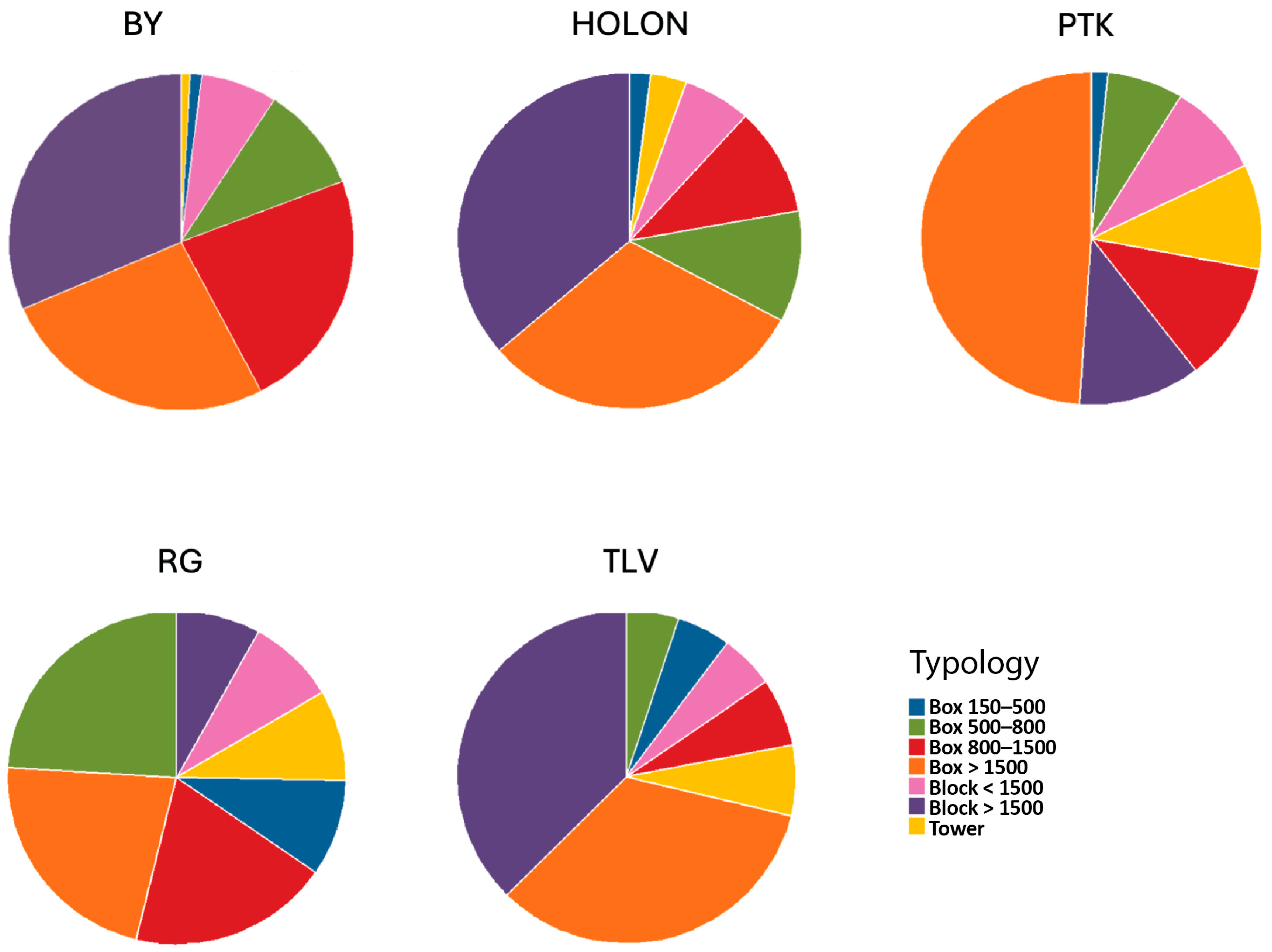
Across the five cities, the distribution of typologies within total shared residential land area varies substantially (
Table 1). Box > 1500 represents the largest share on average in the metropolitan residential fabric, accounting for 33% on average of total shared residential land area, with values ranging from 18% in Ramat Gan to 46% in Petah Tikva. Its prominence across all five cities indicates that large-lot box configurations constitute a major component of shared residential land in the metropolitan region.
As shown in
Figure 3, large-lot Box typologies consistently account for a substantial share of shared residential land in all five cities. By contrast, the Box 150–500, Block < 1500, and Tower typologies, remain comparatively limited in extent and relatively stable in their proportional representation. The remaining typologies display stronger inter-city variation, pointing to differences in local development histories and residential growth patterns.
Table 1 further clarifies these patterns by presenting the mean share of each typology across the five cities alongside their indicative mean building dimensions. Box 150–500, Block < 1500, and Tower each account for approximately 5–6% of shared residential land on average. In contrast, Box 500–800 and Box 800–1500 account for the larger shares, approximately 16% and 20%, respectively, and show greater variation between cities. These proportions should be interpreted together with the indicative building dimensions reported in
Table 1, which further clarify the morphological differences between typologies. This suggests that while some typologies recur with relative consistency across the metropolitan area, others are more strongly shaped by city-specific morphological trajectories. Because these values are descriptive and are based on five city-level observations, they should be interpreted as indicative patterns rather than statistically tested differences, particularly for typologies with smaller proportional shares.
Taken together, lot size and typological prevalence define the overall spatial footprint of each typology at the city scale. This distribution is analytically significant because city-level PVA estimates are derived from typological prevalence and typology-specific PVA ratios, linking the structure of the residential fabric to the distribution of estimated vegetated potential across the metropolitan area.
3.2. Spatial Variability in Absolute PVA
As shown in the Givatayim field study, PVA size was positively associated with species richness and with broader indicators of biodiversity potential. The PVA values across typologies ranged from 87 m2 to 3139 m2. While the relationship between open area and total lot area was relatively consistent in Givatayim, the metropolitan analysis revealed substantial variation in the estimated PVA share across typologies and cities.
The Block typologies exhibit the highest PVA ratios, reaching 62% in Block > 1500 and 41% in Block < 1500. These values reflect their relatively large lot sizes and indicate that block-based configurations contain some of the largest concentrations of estimated vegetated space within the residential fabric.
These typology-specific ratios were used to estimate PVA across the five cities according to their respective typological compositions. As expected, both the proportion and the absolute extent of estimated PVA vary across cities, reflecting differences in the relative contribution of each typology to the total estimated PVA of shared residential land.
Table 2 reports the absolute values of shared residential Lot Area (LA), Open Area (OA), and the PVA by typology and city.
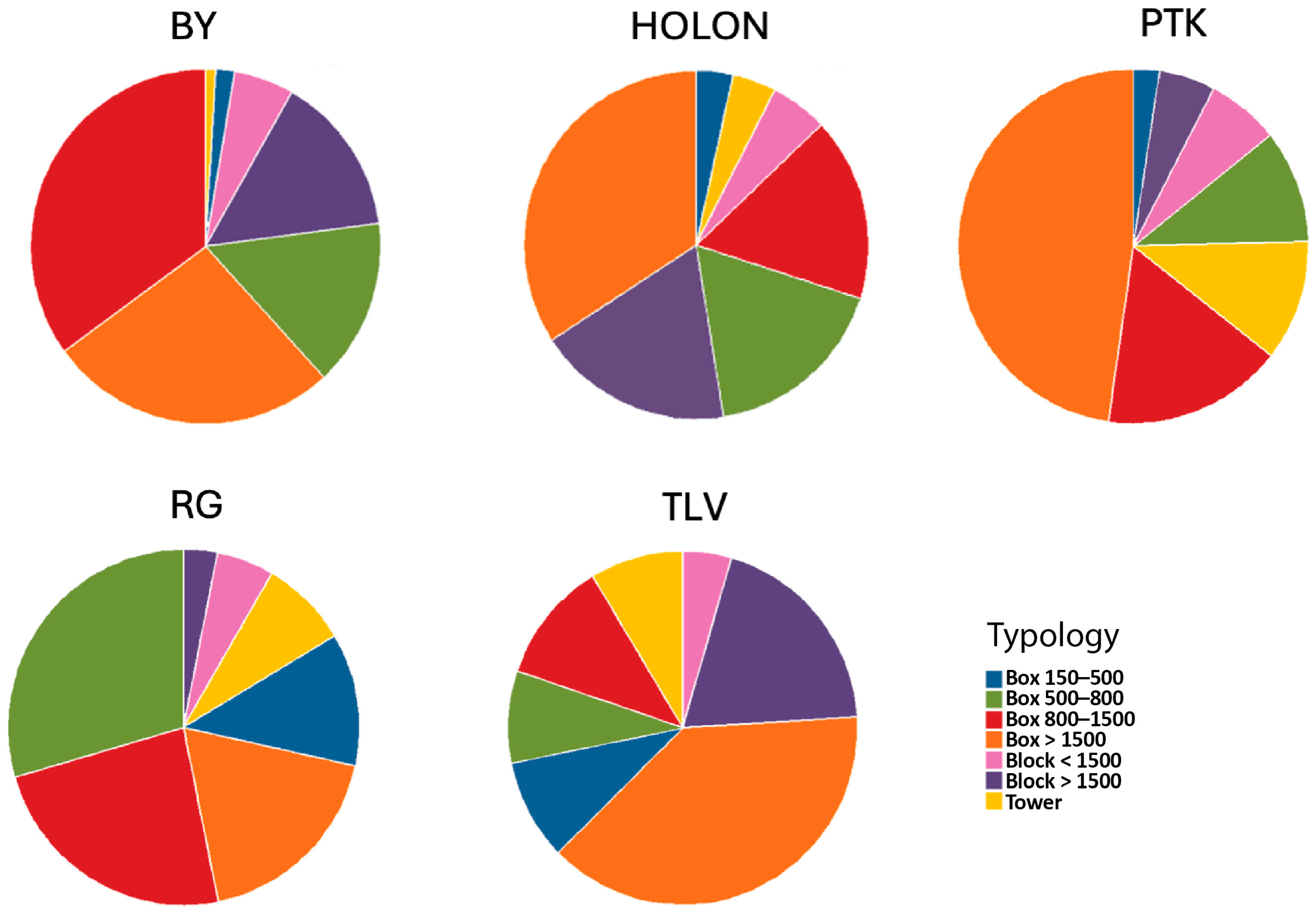
Figure 4 shows the relative contribution of each typology to total city-level PVA.
Overall, the analysis shows that estimated PVA accounts for an average of 31.5% of the total lot area of shared residential parcels, with city-level values ranging from 24.6% in Ramat Gan to 33.9% in Tel Aviv-Yafo. These differences indicate that estimated vegetated potential within shared residential land is unevenly distributed across cities and typological configurations.
3.3. Chronological Order and Timing of Emergence
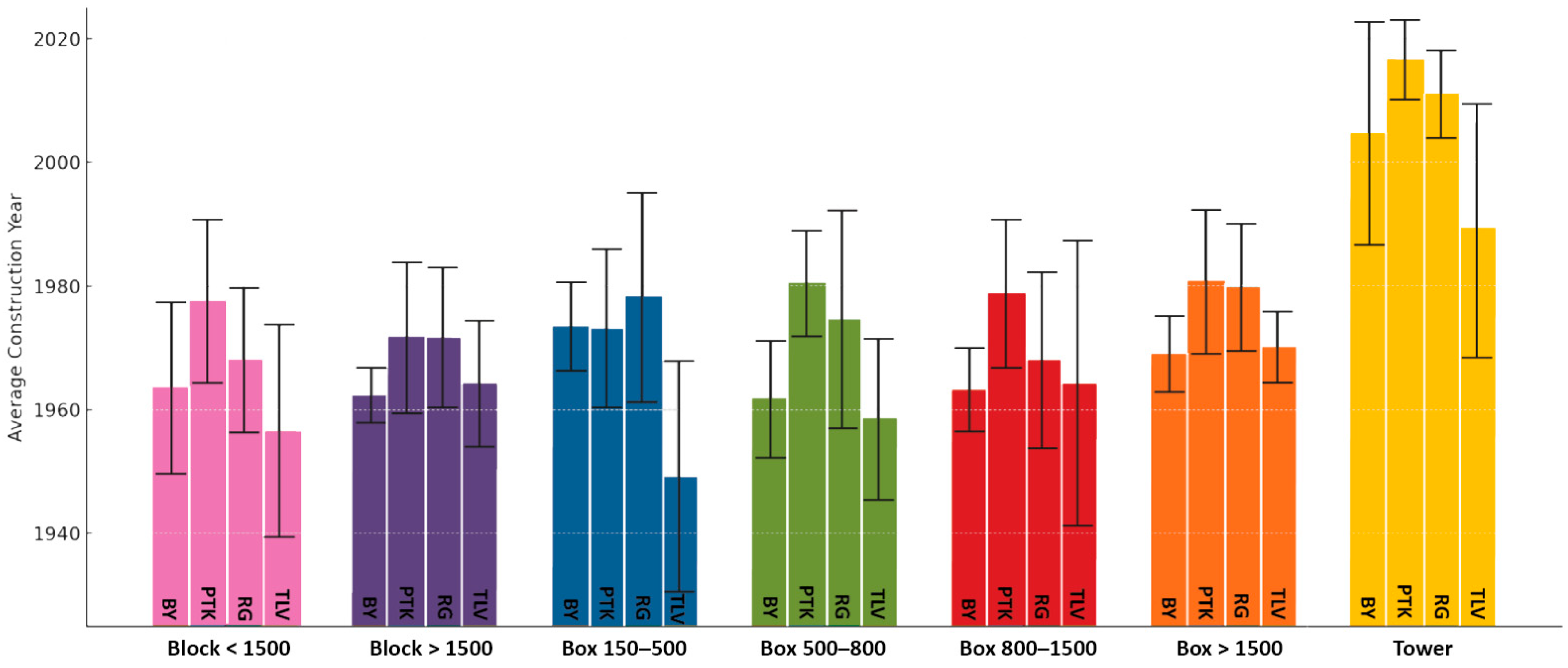
The chronological analysis of the seven typologies in the four documented cities shows that, although construction periods vary between cities, each typology is associated with a distinct period of development. The analysis focuses on typologies older than 45 years, given that redevelopment pressure in Israel often increases after roughly 50–60 years.
The classification of typologies with a median construction year prior to 1980 as having high renewal potential is grounded in both empirical and policy-based considerations. In the Israeli context, residential buildings typically enter a phase of intensified redevelopment pressure after approximately 50–60 years, driven by structural aging, economic obsolescence, and increasing land values. This temporal window is formally reflected in national planning frameworks, most notably TAMA 38, which designates pre-1980 buildings as structurally vulnerable and prioritizes them for reinforcement or redevelopment. Accordingly, the 1980 threshold serves as a proxy for identifying typologies that have entered or exceeded this commonly observed renewal cycle. Rather than representing a fixed cutoff, it operationalizes a broader temporal logic linking building life cycles, regulatory criteria, and redevelopment dynamics. This approach allows the analysis to capture spatial concentrations of typologies that are systematically exposed to renewal pressures, thereby enabling the examination of their cumulative implications for estimated vegetated potential at the metropolitan scale.
Based on building permit records, the five cities show broadly similar development trajectories, despite differences in timing and urban context. The earliest identified typology differs between cities, reflecting distinct local development histories. Tel Aviv-Yafo consistently exhibits the earliest construction periods, consistent with its historical role as the metropolitan core, whereas Petah Tikva tends to display the latest construction years across most typologies. This pattern is consistent with earlier analyses of metropolitan growth in the Tel Aviv region, which describe urban expansion as progressing outward from the core toward later-developing municipalities such as Petah Tikva [
28]. The Tower typology is the principal exception: it is characterized by substantially later construction periods and larger gaps between mean and median values, indicating a more uneven and right-skewed development pattern shaped by early pioneering projects followed by later waves of expansion.
Figure 5 presents the distribution of construction years in the four documented cities (means ± SE) by typology.
Across the four examined cities, the Tower typology consistently represents the most recent phase of residential development. By contrast, with the exception of Box > 1500, all other typologies have an average age exceeding 45 years, placing them within the time range typically associated with redevelopment pressure. These findings suggest that, although typologies share common structural definitions, their chronological distribution varies across cities.
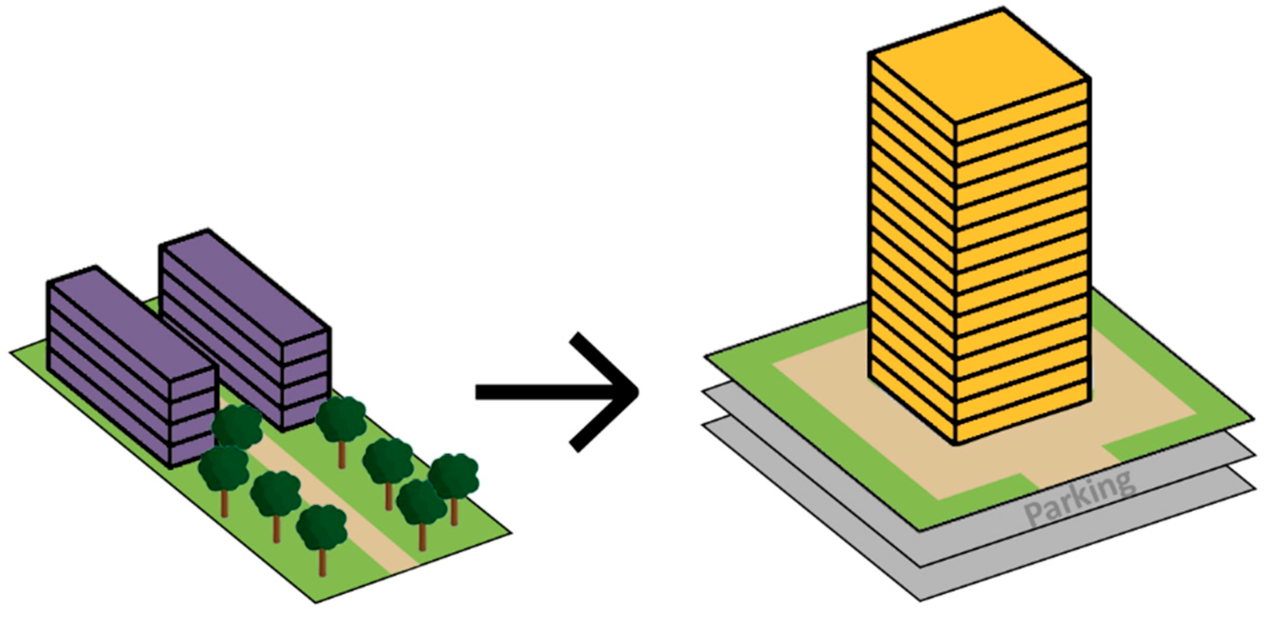
The sequence of typological emergence, from earlier low-rise residential forms to more recent high-density construction, is also associated with differences in the amount of open space retained within the residential fabric and, consequently, the potential for spatial ecological continuity (
Figure 6). With the exception of Box > 1500 and Tower, most typologies are older than 45 years and are therefore more likely to be exposed to renewal processes in the coming decades.
Chronology thus intersects with patterns of estimated vegetated potential, highlighting the potential exposure of vegetated residential land to future regeneration processes. At the same time, the more recent Tower typology represents a distinct configuration typically associated with higher building density, reduced soil continuity, and more intensive maintenance regimes, suggesting a different set of ecological conditions compared to earlier typologies.
3.4. Cluster Morphology and Dispersion Patterns
Cluster analysis makes it possible to examine shared residential yards as spatially connected structures rather than as isolated parcels. By identifying contiguous segments with similar typological and morphological characteristics, this approach reveals spatial patterns that are not visible at the parcel scale. At the same time, it does not capture dispersed parcels that may also contain significant localized PVA (as estimated here).
Across the five cities, clusters form coherent spatial units that reflect concentrations of shared residential typologies. Some areas are characterized by clusters dominated by a single typology, whereas others contain mixed typological assemblages in proximity. In these cases, spatial continuity does not depend on strict typological uniformity, as adjacent typologies may still collectively generate substantial PVA (as estimated here).
Clusters exceeding 10,000 m2, selected as a practical threshold for examining coordinated, non-parcel-based redevelopment, reveal distinct city-specific spatial configurations. Mid- and large-lot Box typologies (800–1500 and >1500 m2) consistently dominate the formation of large clusters, whereas Block typologies tend to remain more fragmented. Although clusters account for a substantial share of total shared residential land area (34–53%), the PVA contained within them represents only 7–14% of total shared residential yards.
Table 3 summarizes the total shared residential land area contained within clusters larger than 10,000 m
2, by typology and city.
Table 4 reports the PVA contained within clusters larger than 10,000 m
2 allowing comparison between typologies in terms of their contribution to vegetated space. Taken together, these descriptive patterns suggest that spatial concentration alone may not fully explain variation in estimated PVA, which also appears to be related to typological composition; this interpretation is based on comparative descriptive patterns rather than formal statistical testing.
When considered alongside the chronological structure identified above, these spatial concentrations acquire additional significance. Many large clusters, whether homogeneous or mixed, are composed of typologies older than 45 years and therefore fall within the prevailing 50–60-year renewal cycle. Substantial and spatially contiguous vegetated space is therefore often located in areas that may be subject to redevelopment in the coming decades.
This analysis highlights areas where redevelopment pressure overlaps with concentrated vegetated potential. At the same time, the cluster-based perspective captures only one dimension of renewal exposure. Typologies do not need to form large, coherent clusters in order to face redevelopment pressures; older residential forms may also appear as dispersed or fragmented segments and still be subject to similar renewal dynamics.
Taken together, the findings suggest that cumulative changes in vegetated space may occur not only through parcel-level transformation, but also through the redevelopment of spatially connected typological assemblages.
4. Discussion
The results show that estimated vegetated potential (associated with ecological diversity and species richness) is unevenly distributed across the metropolitan residential fabric. Approximately one third of shared residential land is estimated to be potentially vegetated and thus constitutes a form of distributed vegetated infrastructure that is not explicitly addressed within prevailing urban regeneration frameworks. Mid- and large-lot Box and Block typologies, particularly Box 800–1500 and Box > 1500, are associated with a disproportionate share of estimated PVA and are also more likely to form large continuous clusters. At the same time, citywide typological prevalence does not necessarily correspond to cluster-level spatial significance, since some widespread typologies remain spatially fragmented. These patterns indicate that shared residential yards function as components of the urban ecological system. The argument does not assume ecological equivalence across individual yards; rather, it concerns the patterned accumulation of functionally similar spatial units across the urban fabric. Under conditions of ongoing urban renewal and densification, urban ecological functioning may depend not only on public open spaces, but also on this accumulated vegetated potential.
From a spatial perspective, residential yards constitute a substantial share of urban green space. In Givatayim, for example, they occupy approximately one-third of the urban area and far exceed the extent of the city’s formal parks and public open spaces [
25]. This distribution indicates that a large proportion of permeable soil and vegetated potential is located within collectively owned residential land, outside direct municipal management and typically excluded from prevailing conceptions of urban ecological infrastructure [
20,
27].
Shared residential yards also form a fine-grained mosaic of ground-level habitats within the built fabric and may provide structural conditions associated with higher plant diversity in dense urban environments. Even relatively small yards can support meaningful levels of plant diversity, particularly spontaneous vegetation [
29,
30]. This contribution is closely tied to soil-based functions. In older urban fabrics, yards often retain continuous, unsealed soils of sufficient depth to support infiltration, subsurface moisture retention, and microclimatic regulation, functions that are increasingly scarce in highly impervious environments. By contrast, renewal processes involving underground parking and soil sealing can substantially reduce these functions [
6].
To connect field-based ecological observations with broader urban-scale patterns, this study uses residential typologies as context-sensitive analytical units. Here, typologies function as structural configurations that combine built form, soil exposure, spatial layout, and likely maintenance regimes. They link lot size, PVA, maintenance regimes, and exposure to renewal processes, thereby connecting spatial form to estimated vegetated potential. Because these typologies recur across many parcels and across multiple cities, they provide a basis for interpreting ecological findings at broader spatial scales. Residential forms occupying parcels of similar size may differ markedly in estimated vegetated potential because of variation in soil continuity, surface sealing, and management intensity [
30,
31].
Residential typologies tend to cluster into cohesive spatial units. These clusters create conditions for greater continuity of soil, vegetation, and open space than is visible at the parcel level alone. Similar outcomes may emerge where adjacent typologies share key functional characteristics, particularly relatively low maintenance intensity and sufficient PVA.
The chronological analysis adds a temporal dimension to these patterns. Residential typologies did not emerge along a single linear trajectory, but through discontinuous waves of development, such that different periods of construction are associated with different ecological configurations. These typologies are also embedded within redevelopment cycles that often intensify after roughly 50–60 years. As a result, the ecological characteristics associated with shared residential yards are time-bound and potentially vulnerable to synchronized transformation once renewal processes begin.
Within this framework, maintenance regimes operate as ecological filters whose effects accumulate over time. Field observations suggest that yards associated with older residential typologies are often characterized by moderate maintenance intensity and relatively limited disturbance, conditions that may allow soil continuity and spontaneous vegetation to persist over extended periods. As these typologies approach the end of their renewal cycle, however, they are frequently subject to redevelopment processes involving underground parking, soil sealing, and intensified landscape management. Such interventions tend to reduce PVA and disrupt soil-based ecological functions including areas where large, contiguous residential landscapes are transformed simultaneously.
A central implication of the analysis is the temporal mismatch between estimated vegetated potential and the timing of renewal. Residential typologies from the second half of the twentieth century are often also among the first to face redevelopment pressure, in part because of their relatively large parcel sizes. This creates a heightened risk that urban renewal will disproportionately affect some of the areas with relatively high levels of vegetated potential. These effects accumulate over time: building replacement, underground parking, and shifts in maintenance regimes may alter ecological trajectories at neighborhood and city scales [
6,
20,
29,
31].
These findings highlight the limitations of parcel-based approaches for understanding ecological functioning in dense cities. Although residential yards are planned and managed at the parcel level, key variables such as PVA, soil continuity, and maintenance regimes organize into system-level patterns through typologies, clustering, and chronological coherence. Moreover, while PVA is embedded within privately or collectively owned land, its ecological functions, including infiltration, microclimatic regulation, habitat continuity, and biodiversity support, extend beyond parcel boundaries and generate wider public benefits. Leaving these processes to parcel-by-parcel decision-making risks systematic under-provision of ecological functions [
6,
30].
These insights point to the need for a shift from parcel-based planning toward system-oriented frameworks for urban renewal. Rather than focusing solely on individual parcels or imposing uniform parcel-level requirements, planning approaches should operate at intermediate spatial scales. This could include coordinating renewal across adjacent parcels, setting minimum thresholds for PVA at the cluster level, and explicitly recognizing shared residential yards as components of urban ecological infrastructure.
This dynamic reflects what Odum & Kahn’ described as the tyranny of small decisions, whereby numerous individually rational and seemingly minor decisions collectively produce large-scale and unintended environmental outcomes [
32]. In the context of shared residential yards, decisions such as the introduction of underground parking, partial soil sealing, or shifts toward more intensive landscape management may accumulate spatially and temporally, reshaping vegetated potential at the neighborhood scale without being addressed as a single planning problem [
32]. Within this perspective, maintenance regimes emerge as a critical system-level variable rather than a purely aesthetic or operational concern. When low- or high-intensity maintenance patterns are repeated across multiple parcels, they effectively function as a form of distributed governance with direct ecological consequences [
33,
34].
PVA, analogous to urban trees, can be interpreted as a form of embedded public good [
11]. Although located within privately or collectively owned residential land, the ecological functions they provide extend beyond parcel boundaries and generate benefits at the scale of the urban system. This broader contribution justifies planning and management approaches that move beyond fragmented parcel-based decision-making and explicitly recognize the cumulative ecological value of shared residential land.
Shared residential yards should therefore be understood as part of a wider spatial system rather than as isolated parcels. By linking field-based ecological observations to typological structures, spatial aggregation, and chronological development, the analysis indicates that variables such as PVA, soil continuity, and maintenance regimes organize into system-level patterns with significant implications for urban biodiversity and climate adaptation. Accordingly, the ecological consequences of urban renewal cannot be adequately understood or governed at the parcel level alone. They call for planning frameworks operating at neighborhood and city scales that coordinate renewal processes and account for the continuity of soil and vegetated space. Without such intervention, incremental redevelopment and intensified maintenance practices are likely to erode the accumulated ecological capacity embedded within dense residential fabrics.
Residential typologies can thus be understood as ecological units that structure the distribution of biodiversity-supporting conditions. The study further conceptualizes Potentially Vegetated Area (PVA) as a form of distributed ecological infrastructure embedded within residential land and identifies urban renewal as a key mechanism through which this vegetated potential is systematically transformed over time.
This study has several limitations. First, PVA is used as a proxy for vegetated potential and does not account for habitat quality, species composition, or realized biodiversity. The analysis also does not incorporate socio-economic variables that may influence maintenance regimes and management practices. Second, metropolitan estimates are derived from typology-based extrapolation of field data collected in Givatayim and therefore should be interpreted as indicative rather than directly measured values. Because PVA values outside Givatayim were estimated using typology-specific coefficients, applying inferential statistical models to test the relationship between typology and PVA would risk circularity, as typology is embedded in the estimation procedure itself. Therefore, the analysis focuses on spatial distribution patterns rather than causal estimation. Third, the empirical basis for PVA estimation relies on a limited sample of residential plots, particularly for the seventh typology. Finally, the analysis is descriptive and is intended to identify spatial patterns of estimated vegetated potential rather than to statistically test the independent effects of typology, clustering, or urban context. These limitations should be considered when interpreting the results, which are best understood as a typology-based framework for estimating vegetated potential rather than as a direct measurement of metropolitan ecological capacity.
5. Conclusions
This study suggests that shared residential yards constitute a significant but largely overlooked component of vegetated infrastructure underpinning ecological functions in dense cities. By extending field-based ecological observations from Givatayim to a metropolitan analysis across five additional cities in the Tel Aviv region, the study proposes that the estimated vegetated biodiversity potential of residential land is associated with interactions between typological form, spatial clustering, and chronological exposure to urban renewal.
The findings indicate that the seven-typology framework captures the vast majority of shared residential areas across the metropolitan study area and provides a consistent basis for comparing residential fabrics across cities. Typologies differ not only in prevalence, but also in their associated PVA, their capacity to form spatially continuous clusters, and their position within urban development and renewal cycles. Mid- and large-lot Box typologies account for a substantial share of the vegetated potential embedded in the residential fabric, while many of the typologies with relatively high estimated vegetated potential are also those most exposed to redevelopment pressure in the coming decades.
These results highlight a structural tension within contemporary urban renewal processes. The distributed vegetated potential embedded in shared residential land is concentrated in morphological configurations that are increasingly subject to transformation, soil sealing, and potentially intensified management. As a result, changes in vegetated space and associated ecological conditions in dense cities are likely to occur not only through the loss of individual parcels, but through the cumulative redevelopment of typologically and spatially connected residential areas.
The study therefore argues that shared residential yards should be understood not as residual private open space, but as a distributed ecological resource with system-level significance. Their contribution to infiltration, microclimatic regulation, habitat continuity, and urban biodiversity extends beyond parcel boundaries and cannot be adequately understood through parcel-based planning alone. A more effective planning response requires system-oriented approaches that recognize typological and cluster-level vegetated potential, coordinate renewal across adjacent parcels, and incorporate soil continuity, vegetated area, and maintenance regimes into the governance of residential transformation.
More broadly, the study suggests that ecological functioning in dense urban environments emerges through the patterned accumulation of everyday residential spaces. Recognizing this distributed infrastructure is important if cities are to pursue urban renewal while also sustaining biodiversity and climate adaptation capacity under continued densification.