


Peripheral: Resilient Hydrological Infrastructures

Abstract
1. Introduction
1.1. Open Systems Approach: CAS and SETS
1.2. Decentering the Human City
1.3. Infrastructures
1.4. Peripheralizing Existing Centrisms
1.5. Resilience, Water-Sensitivity
2. Materials and Methods
3. Results
3.1. Observing the Urban Design States in their Niches, and Future Transition Proposals
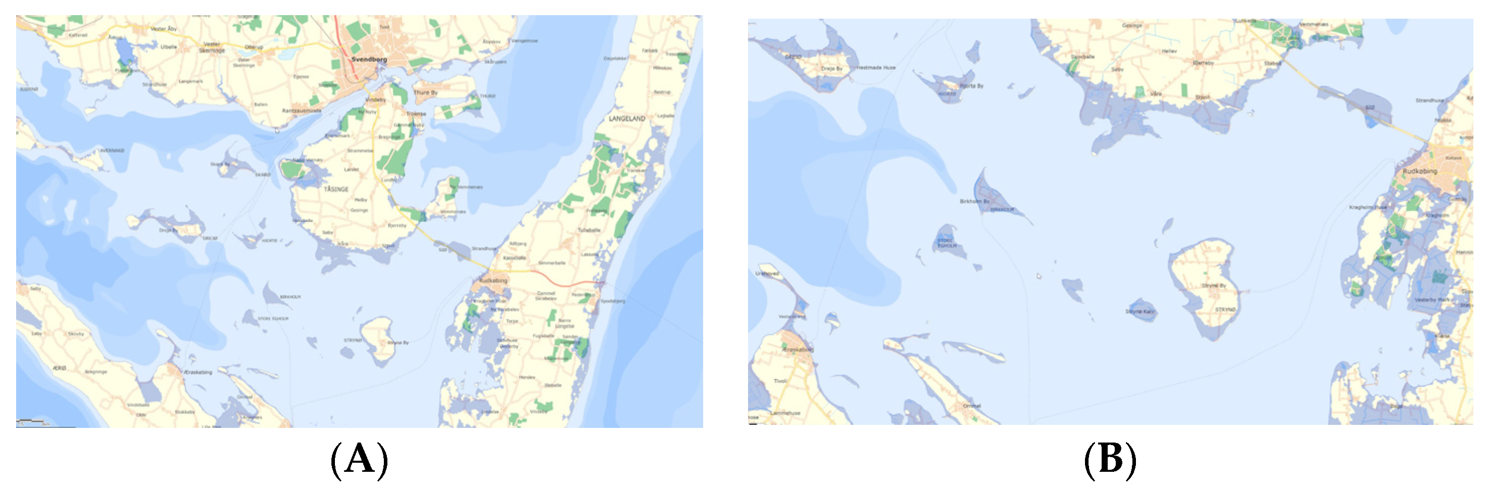
3.1.1. Birkholm
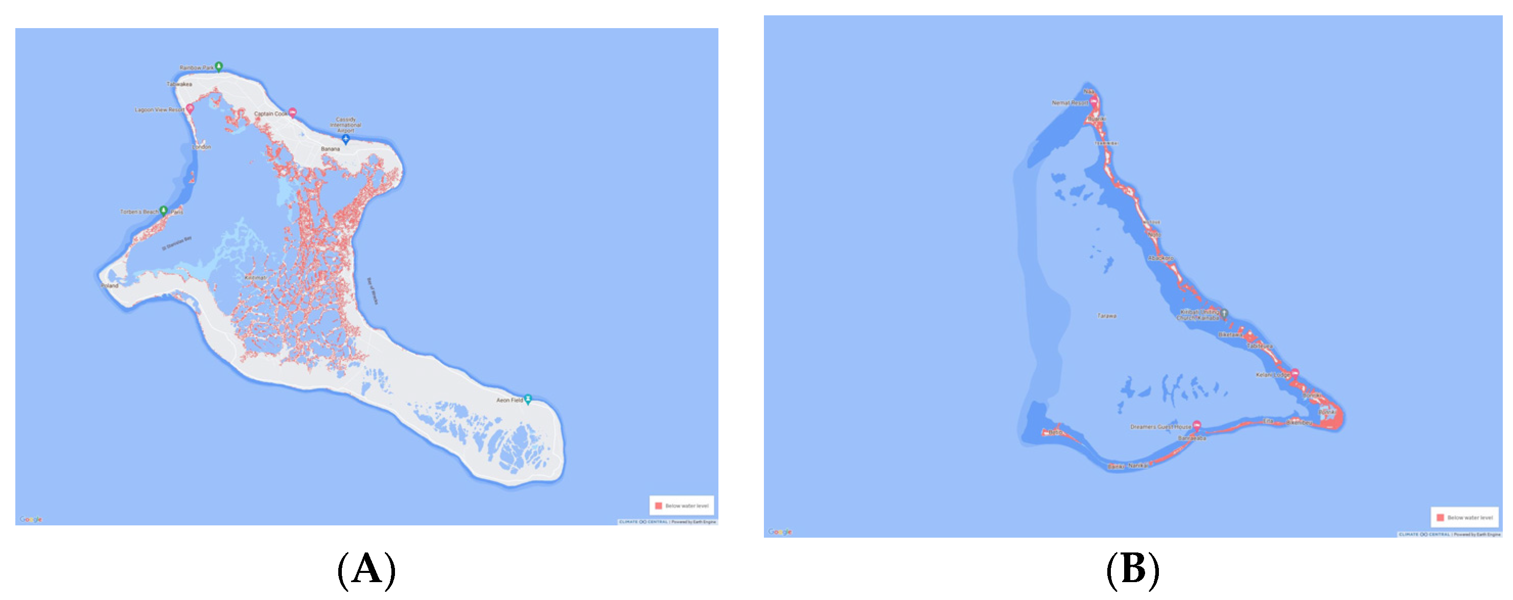
3.1.2. Tarawa
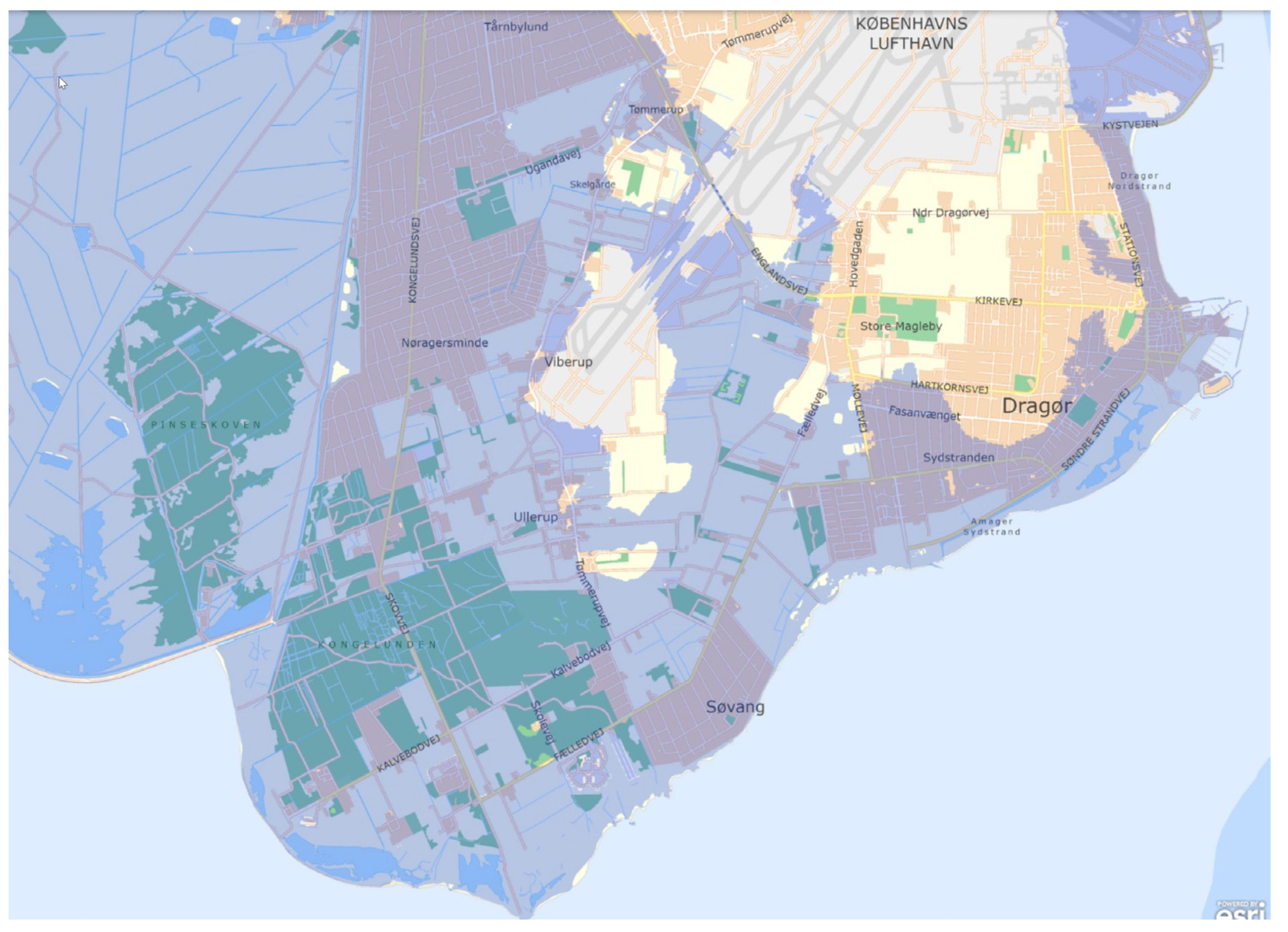
3.1.3. Dragør
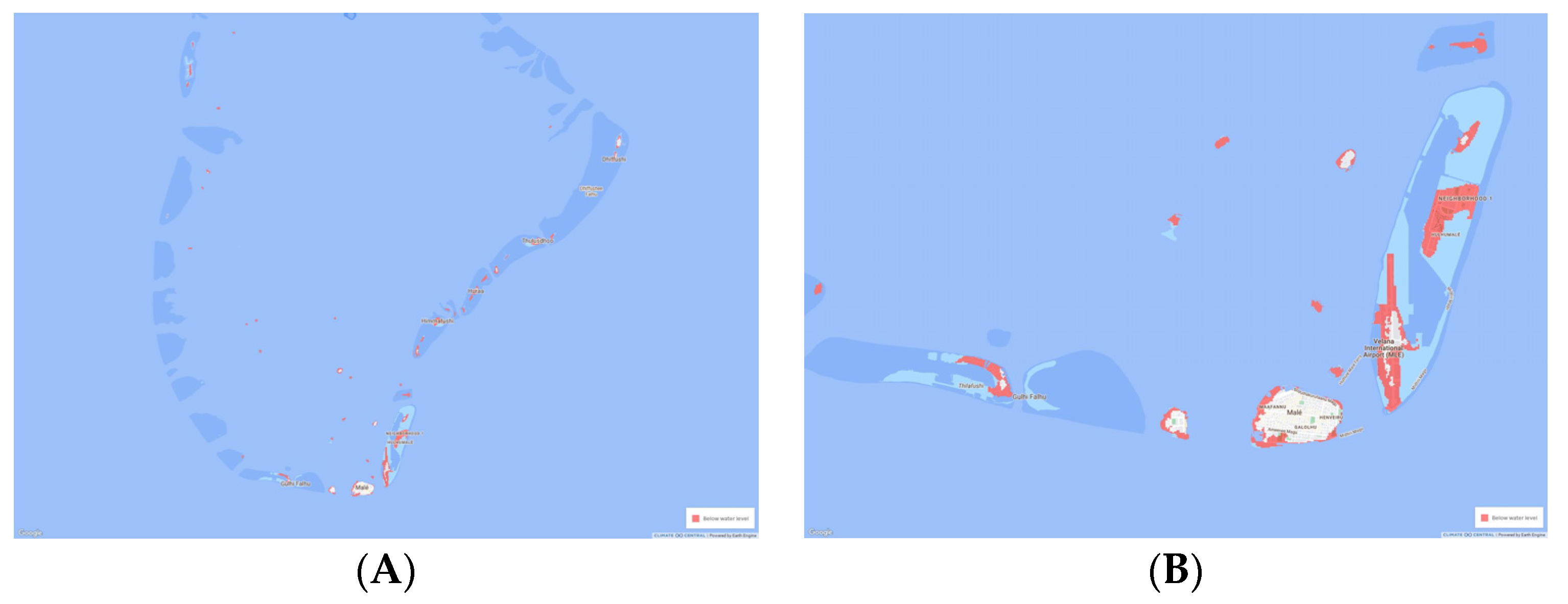
3.1.4. Malé
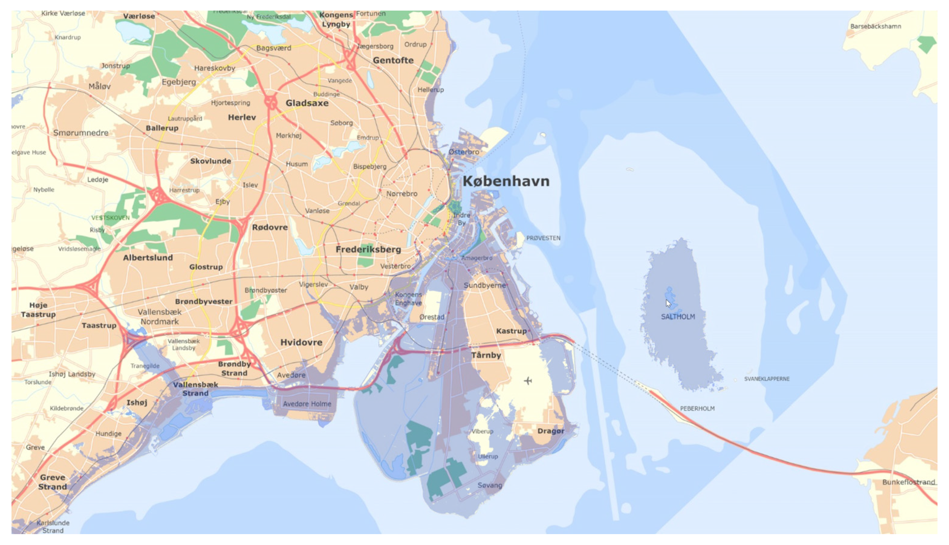
3.1.5. Copenhagen
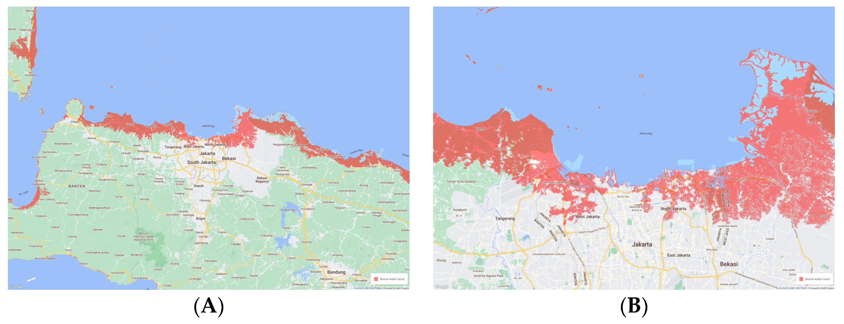
3.1.6. Jakarta
4. Discussion
4.1. Countering the Human City
4.1.1. Transitions beyond Social Monism and Anthropocentrism
4.1.2. Displacing towards Interdependency
4.2. Delimiting City Centrism
4.2.1. Centrisms: Global North and Global South, Central, and Peripheral Cities
4.2.2. Decentralizations
4.2.3. Decentralized Bottom-Up Movements from Peripheries
4.3. Resilience as Peripheral
4.3.1. Resilience: Persistence through Flexibility
4.3.2. Adaptability through Coupled Social–Ecological Systems
4.4. Designing with Discrepant Timescales
5. Conclusions: Future Ecotone Environments
Funding
Institutional Review Board Statement
Informed Consent Statement
Data Availability Statement
Acknowledgments
Conflicts of Interest
References
- Masson-Delmotte, V.; Zhai, P.; Pirani, A.; Connors, S.L.; Pean, C.; Berger, S.; Caud, N.; Chen, Y.; Goldfarb, L.; Gomis, M.I.; et al. (Eds.) Climate Change 2021: The Physical Science Basis. Contribution of Working Group I to the Sixth Assessment Report of the Intergovernmental Panel on Climate Change; Cambridge University Press: Cambridge, UK, 2021. [Google Scholar]
- IPCC. IPCC Special Report on the Ocean and Cryosphere in a Changing Climate; Cambridge University Press: Cambridge, UK, 2019. [Google Scholar]
- Mimura, N. Sea-level rise caused by climate change and its implications for society. Proc. Jpn. Acad. 2013, 89, 281–301. [Google Scholar] [CrossRef] [PubMed]
- Nicholls, R.J. Chapter 2—Adapting to Sea-Level Rise. In Resilience; Zommers, Z., Alverson, K., Eds.; Elsevier: Amsterdam, The Netherlands, 2018; pp. 13–29. [Google Scholar]
- Nicholls, R.J.; Marinova, N.; Lowe, J.A.; Brown, S.; Vellinga, P.; de Gusmão, D.; Hinkel, J.; Tol, R.S.J. Sea-level rise and its possible impacts given a ‘beyond 4 °C world’ in the twenty-first century. Philos. Trans. Math. Phys. Eng. Sci. 2011, 369, 161–181. [Google Scholar] [CrossRef]
- Hauer, M.E.; Fussell, E.; Mueller, V.; Burkett, M.; Call, M.; Abel, K.; McLeman, R.; Wrathall, D. Sea-level rise and human migration. Nat. Rev. Earth Environ. 2020, 1, 28–39. [Google Scholar] [CrossRef]
- Al, S. Adapting Cities to Sea Level Rise Green and Gray Strategies, 1st ed.; Island Press/Center for Resource Economics: Washington, DC, USA, 2018. [Google Scholar]
- Hill, K. Coastal infrastructure: A typology for the next century of adaptation to sea-level rise. Front. Ecol. Environ. 2015, 13, 468–476. [Google Scholar] [CrossRef]
- Hill, K. Climate Change: Implications for the Assumptions, Goals and Methods of Urban Environmental Planning. Urban Plan. 2016, 1, 103–113. [Google Scholar] [CrossRef]
- Hirschfeld, D.; Hill, K.; Plane, E. Adapting to Sea Level Rise: Insights from a New Evaluation Framework of Physical Design Projects. Coast. Manag. 2021, 49, 636–661. [Google Scholar] [CrossRef]
- Brears, R.C. Blue and Green Cities the Role of Blue-Green Infrastructure in Managing Urban Water Resources, 1st ed.; Palgrave Macmillan UK: London, UK, 2018. [Google Scholar]
- Shannon, K. Water Urbanisms; Shannon, K., De Meulder, B., Eds.; SUN: Amsterdam, The Netherlands, 2008; p. 119. [Google Scholar]
- Shannon, K. Eco-engineering for Water: From Soft to Hard and Back. In Resilience in Ecology and Urban Design: Linking Theory and Practice for Sustainable Cities; Pickett, S.T.A., Cadenasso, M.L., McGrath, B., Eds.; Springer: Dordrecht, The Netherlands, 2013; pp. 163–182. [Google Scholar]
- Mossop, E. Sustainable Coastal Design and Planning; CRC Press: Milton, UK, 2019. [Google Scholar]
- Buchanan, R. Wicked Problems in Design Thinking. Des. Issues 1992, 8, 5–21. [Google Scholar] [CrossRef]
- Incropera, F.P. Climate Change: A Wicked Problem: Complexity and Uncertainty at the Intersection of Science, Economics, Politics, and Human Behavior; Cambridge University Press: Cambridge, UK, 2016. [Google Scholar]
- Rittel, H.W.J.; Webber, M.M. Dilemmas in a General Theory of Planning. Policy Sci. 1973, 4, 155–169. [Google Scholar] [CrossRef]
- Batty, M. Cities and Complexity; MIT Press: Cambridge, MA, USA, 2005. [Google Scholar]
- Ekman, U. Smart City Planning: Complexity. Int. J. E-Plan. Res. 2018, 7, 1–21. [Google Scholar] [CrossRef]
- Grimm, N.; Blasquez, M.; Chester, M.; Cook, E.; Groffman, P.; Iwaniec, D.; McPhearson, T.; Miller, T.; Muñoz-Erickson, T.; Redman, C. A Social-Ecological-Technical Systems Approach to Understanding Urban Complexity and Building Climate Resilience. In Proceedings of the IFoU 2018: Reframing Urban Resilience Implementation: Aligning Sustainability and Resilience, Barcelona, Italy, 10–12 December 2018; MDPI: Basel, Switzerland. [Google Scholar]
- Healey, P. Urban Complexity and Spatial Strategies: Towards a Relational Planning for Our Times; Taylor and Francis: Florence, OR, USA, 2006. [Google Scholar]
- Innes, J.E.; Booher, D.E. Planning with Complexity: An Introduction to Collaborative Rationality for Public Policy, 2nd ed.; Routledge: Abingdon, UK, 2018. [Google Scholar]
- Portugali, J. Complexity Theories of Cities Have Come of Age, An Overview with Implications to Urban Planning and Design; Springer: Berlin/Heidelberg, Germany; New York, NY, USA, 2012. [Google Scholar]
- Roo, G.D.; Hillier, J.; Wezemael, J.V. Complexity and Planning: Systems, Assemblages and Simulations; Ashgate: Burlington, VT, USA, 2012; p. 443. [Google Scholar]
- Sengupta, U.; Rauws, W.S.; de Roo, G. Planning and complexity: Engaging with temporal dynamics, uncertainty and complex adaptive systems. Environ. Plan. B Plan. Des. 2016, 43, 970–974. [Google Scholar] [CrossRef]
- Anand, N.; Gupta, A.; Appel, H. The Promise of Infrastructure; Duke University Press: Durham, NC, USA, 2018. [Google Scholar]
- Addie, J.-P.D.; Glass, M.R.; Nelles, J. Regionalizing the infrastructure turn: A research agenda. Reg. Stud. Reg. Sci. 2020, 7, 10–26. [Google Scholar] [CrossRef]
- Siemiatycki, M.; Enright, T.; Valverde, M. The gendered production of infrastructure. Prog. Hum. Geogr. 2020, 44, 297–314. [Google Scholar] [CrossRef]
- Easterling, K. Extrastatecraft: The Power of Infrastructure Space; Verso: London, UK; New York, NY, USA, 2014; p. 252. [Google Scholar]
- Schindler, S.; Kanai, J.M. Getting the territory right: Infrastructure-led development and the re-emergence of spatial planning strategies. Reg. Stud. 2021, 55, 40–51. [Google Scholar] [CrossRef]
- Wiig, A.; Silver, J. Turbulent presents, precarious futures: Urbanization and the deployment of global infrastructure. Reg. Stud. 2019, 53, 912–923. [Google Scholar] [CrossRef]
- Wachsmuth, D. Infrastructure Alliances: Supply-Chain Expansion and Multi-city Growth Coalitions. Econ. Geogr. 2017, 93, 44–65. [Google Scholar] [CrossRef]
- Zimmerman, R. Making Infrastructure Competitive in an Urban World. Ann. Am. Acad. Political Soc. Sci. 2009, 626, 226–241. [Google Scholar] [CrossRef]
- Turner, C. Regional Infrastructure Systems: The Political Economy of Regional Infrastructure; Edward Elgar Publishering, Inc.: Northampton, MA, USA, 2018. [Google Scholar]
- Kirkpatrick, L.O.; Smith, M.P. The Infrastructural Limits to Growth: Rethinking the Urban Growth Machine in Times of Fiscal Crisis. Int. J. Urban Reg. Res. 2011, 35, 477–503. [Google Scholar] [CrossRef]
- Amin, A. Lively Infrastructure. Theory Cult. Soc. 2014, 31, 137–161. [Google Scholar] [CrossRef]
- Amin, A.; Thrift, N.J. Seeing Like a City; Polity Press: Cambridge, UK; Malden, MA, USA, 2016; p. 15. [Google Scholar]
- Chattopadhyay, S. Unlearning the City: Infrastructure in a New Optical Field; University of Minnesota Press: Minneapolis, MN, USA, 2012. [Google Scholar]
- Hetherington, K. Infrastructure, Environment, and Life in the Anthropocene; Duke University Press: Durham, NC, USA, 2019. [Google Scholar]
- Heynen, N.; Kaika, M.; Swyngedouw, E.; Heynen, N.; Swyngedouw, E. The Nature of Cities: Urban Political Ecology and the Politics of Urban Metabolism; Routledge: London, UK, 2006. [Google Scholar]
- Monstadt, J. Conceptualizing the Political Ecology of Urban Infrastructures: Insights from Technology and Urban Studies. Environ. Plan. A 2009, 41, 1924–1942. [Google Scholar] [CrossRef]
- Schmid, C. Journeys through planetary urbanization: Decentering perspectives on the urban. Environ. Plan. D Soc. Space 2018, 36, 591–610. [Google Scholar] [CrossRef]
- Brenner, N. Implosions/Explosions: Towards A Study of Planetary Urbanization; Jovis: Berlin, Germany, 2014. [Google Scholar]
- Brenner, N. Debating planetary urbanization: For an engaged pluralism. Environ. Plan. D Soc. Space 2018, 36, 570–590. [Google Scholar] [CrossRef]
- Reis, N.; Lukas, M. Beyond the Megacity: New Dimensions of Peripheral Urbanization in Latin America; University of Toronto Press: Toronto, ON, USA, 2022. [Google Scholar]
- Arboleda, M. In the Nature of the Non-City: Expanded Infrastructural Networks and the Political Ecology of Planetary Urbanisation. Antipode 2016, 48, 233–251. [Google Scholar] [CrossRef]
- Filion, P.; Keil, R. Contested Infrastructures: Tension, Inequity and Innovation in the Global Suburb. Urban Policy Res. 2017, 35, 7–19. [Google Scholar] [CrossRef]
- Mason, R.J. Ecoregional Planning: Retreat or Reinvention? J. Plan. Lit. 2011, 26, 405–419. [Google Scholar] [CrossRef]
- Portnov, B.A.; Pearlmutter, D. Sustainable urban growth in peripheral areas. Prog. Plan. 1999, 52, 239–308. [Google Scholar] [CrossRef]
- Ranganathan, M.; Balazs, C. Water marginalization at the urban fringe: Environmental justice and urban political ecology across the North-South divide. Urban Geogr. 2015, 36, 403–423. [Google Scholar] [CrossRef]
- Forman, R.T.T. Urban Regions: Ecology and Planning Beyond the City; Cambridge University Press: Cambridge, UK, 2008. [Google Scholar]
- Forman, R.T.T. Urban Ecology: Science of Cities; Cambridge University Press: Cambridge, UK, 2014. [Google Scholar]
- Grimm, N.B.; Faeth, S.H.; Golubiewski, N.E.; Redman, C.L.; Wu, J.; Bai, X.; Briggs, J.M. Global Change and the Ecology of Cities. Science 2008, 319, 756–760. [Google Scholar] [CrossRef]
- Simmonds, R.; Hack, G. Global City Regions: Their Emerging Forms; Spon: London, UK; New York, NY, USA, 2000; 286p. [Google Scholar]
- Steffen, W.; Richardson, K.; Rockström, J.; Cornell, S.E.; Fetzer, I.; Bennett, E.; Biggs, R.; Vries, D.W. Planetary boundaries: Guiding human development on a changing planet. Science 2015, 347, 736. [Google Scholar] [CrossRef]
- Brundtland, G.H. Our Common Future; Oxford University Press: Oxford, UK, 1987. [Google Scholar]
- Adger, W.N.; Hughes, T.P.; Folke, C.; Carpenter, S.R.; Rockström, J. Social-Ecological Resilience to Coastal Disasters. Science 2005, 309, 1036–1039. [Google Scholar] [CrossRef]
- Allen, A.; Griffin, L.; Johnson, C. Environmental Justice and Urban Resilience in the Global South, 1st ed.; Palgrave Macmillan US: New York, NY, USA, 2017. [Google Scholar]
- Bruckmeier, K. Social-Ecological Transformation, Reconnecting Society and Nature; Palgrave Macmillan UK: London, UK, 2016. [Google Scholar]
- Folke, C.; Carpenter, S.; Walker, B.; Scheffer, M.; Rockström, J. Resilience Thinking: Integrating Resilience, Adaptability and Transformability. Ecol. Soc. 2010, 15, 20. [Google Scholar] [CrossRef]
- Coetzee, C.; Van Niekerk, D.; Raju, E. Disaster resilience and complex adaptive systems theory: Finding common grounds for risk reduction. Disaster Prev. Manag. 2016, 25, 196–211. [Google Scholar] [CrossRef]
- Davoudi, S.; Shaw, K.; Haider, L.J.; Quinlan, A.E.; Peterson, G.D.; Wilkinson, C.; Fünfgeld, H.; McEvoy, D.; Porter, L.; Davoudi, S. Resilience: A Bridging Concept or a Dead End? “Reframing” Resilience: Challenges for Planning Theory and Practice Interacting Traps: Resilience Assessment of a Pasture Management System in Northern Afghanistan Urban Resilience: What Does it Mean in Planning Practice? Resilience as a Useful Concept for Climate Change Adaptation? The Politics of Resilience for Planning: A Cautionary Note: Edited by Simin Davoudi and Libby Porter. Plan. Theory Pract. 2012, 13, 299–333. [Google Scholar] [CrossRef]
- de la Cal, P.; García, M. Urban Resilience: Towards a Global Sustainability. In Urban Visions: From Planning Culture to Landscape Urbanism; Díez Medina, C., Monclús, J., Eds.; Springer International Publishing: Cham, Switzerland, 2018; pp. 227–236. [Google Scholar]
- Fainstein, S. Resilience and Justice. Int. J. Urban Reg. Res. 2015, 39, 157–167. [Google Scholar] [CrossRef]
- Folke, C. Resilience: The emergence of a perspective for social–ecological systems analyses. Glob. Environ. Chang. 2006, 16, 253–267. [Google Scholar] [CrossRef]
- Holling, C.S. Resilience and Stability of Ecological Systems. Annu. Rev. Ecol. Syst. 1973, 4, 1–23. [Google Scholar] [CrossRef]
- McPhearson, T.; Cook, E.M.; Berbés-Blázquez, M.; Cheng, C.; Grimm, N.B.; Andersson, E.; Barbosa, O.; Chandler, D.G.; Chang, H.; Chester, M.V.; et al. A social-ecological-technological systems framework for urban ecosystem services. One Earth 2022, 5, 505–518. [Google Scholar] [CrossRef]
- Meulder, B.; Shannon, K. Designing Ecologies for Resilient Urbanisms. Landsc. Archit. Front. 2018, 6, 12. [Google Scholar] [CrossRef]
- Pickett, S.T.A.; Cadenasso, M.L.; McGrath, B. Resilience in Ecology and Urban Design: Linking Theory and Practice for Sustainable Cities, 1st ed.; Springer: Dordrecht, The Netherlands, 2013; Volume 3. [Google Scholar]
- Sellberg, M.M.; Quinlan, A.; Preiser, R.; Malmborg, K.; Peterson, G.D. Engaging with complexity in resilience practice. Ecol. Soc. 2021, 26, 8. [Google Scholar] [CrossRef]
- Woods, D.D. Four concepts for resilience and the implications for the future of resilience engineering. Reliab. Eng. Syst. Saf. 2015, 141, 5–9. [Google Scholar] [CrossRef]
- Bryant, A.; Charmaz, K. The SAGE Handbook of Current Developments in Grounded Theory; SAGE: London, UK, 2019. [Google Scholar]
- Charmaz, K. Constructing Grounded Theory, 2nd ed.; SAGE: London, UK, 2014. [Google Scholar]
- Clarke, A.E.; Friese, C.; Washburn, R. Situational Analysis: Grounded Theory after the Interpretive Turn, 2nd ed.; SAGE: Los Angeles, CA, USA, 2017. [Google Scholar]
- Glaser, B.G.; Strauss, A.L. Discovery of Grounded Theory: Strategies for Qualitative Research, 1st ed; Taylor and Francis: London, UK, 2017. [Google Scholar]
- Morse, J.M. Developing Grounded Theory: The Second Generation Revisited; Routledge: New York, NY, USA, 2021. [Google Scholar]
- Bergvall-Kåreborn, B.; Ståhlbröst, A. Living lab: An open and citizen-centric approach for innovation. Int. J. Innov. Reg. Dev. 2009, 1, 356–370. [Google Scholar] [CrossRef]
- Bulkeley, H.; Mai, L.; Marvin, S.; McCormick, K.; Voytenko Palgan, Y. Urban Living Labs: Experimenting with City Futures; Routledge, an imprint of Taylor and Francis: Boca Raton, FL, USA, 2018. [Google Scholar]
- Steen, K.Y.G.; van Bueren, E. Urban Living Labs: A Living Lab Way of Working; Amsterdam Institute for Advanced Metropolitan Solutions (AMS): Amsterdam, The Netherlands, 2017. [Google Scholar]
- Holland, J.H. Studying Complex Adaptive Systems. J. Syst. Sci. Complex. 2006, 19, 1–8. [Google Scholar] [CrossRef]
- Holland, J.H. Signals and Boundaries: Building Blocks for Complex Adaptive Systems; MIT Press: Cambridge, MA, USA, 2012. [Google Scholar]
- Lansing, J.S. Complex Adaptive Systems. Annu. Rev. Anthropol. 2003, 32, 183–204. [Google Scholar] [CrossRef]
- Longato, D.; Lucertini, G.; Dalla Fontana, M.; Musco, F. Including Urban Metabolism Principles in Decision-Making: A Methodology for Planning Waste and Resource Management. Sustainability 2019, 11, 2101. [Google Scholar] [CrossRef]
- Lucertini, G.; Musco, F. Circular Urban Metabolism Framework. One Earth 2020, 2, 138–142. [Google Scholar] [CrossRef]
- Newell, J.P.; Cousins, J.J. The boundaries of urban metabolism: Towards a political–industrial ecology. Prog. Hum. Geogr. 2015, 39, 702–728. [Google Scholar] [CrossRef]
- Swyngedouw, E. Circulations and metabolisms: (Hybrid) Natures and (Cyborg) cities. Sci. Cult. 2006, 15, 105–121. [Google Scholar] [CrossRef]
- Thomson, G.; Newman, P. Urban fabrics and urban metabolism—From sustainable to regenerative cities. Resour. Conserv. Recycl. 2018, 132, 218–229. [Google Scholar] [CrossRef]
- Tzaninis, Y.; Mandler, T.; Kaika, M.; Keil, R. Moving urban political ecology beyond the ‘urbanization of nature’. Prog. Hum. Geogr. 2021, 45, 229–252. [Google Scholar] [CrossRef] [PubMed]
- Wachsmuth, D. Three Ecologies: Urban Metabolism and the Society-Nature Opposition. Sociol. Q. 2012, 53, 506–523. [Google Scholar] [CrossRef]
- Espinosa, A.; Harnden, R.; Walker, J. A complexity approach to sustainability—Stafford Beer revisited. Eur. J. Oper. Res. 2008, 187, 636–651. [Google Scholar] [CrossRef]
- Espinosa Salazar, A.M.; Walker, J. A Complexity Approach to Sustainability Theory and Application; Imperial College Press: London, UK, 2011. [Google Scholar]
- Cooper, J.A.G.; Pile, J. The adaptation-resistance spectrum: A classification of contemporary adaptation approaches to climate-related coastal change. Ocean Coast. Manag. 2014, 94, 90–98. [Google Scholar] [CrossRef]
- Kystdirektoratet, M. Kystplanlægger. Available online: https://gis.nst.dk/portal/apps/webappviewer/index.html?id=7d399b34b9ef42d7895569d0ccc0046b (accessed on 7 July 2023).
- Climate Central | Land below 2.5 Meters of Water. Available online: https://coastal.climatecentral.org/map/11/106.8079/-6.131/?theme=water_level&map_type=water_level_above_mhhw&basemap=roadmap&contiguous=true&elevation_model=best_available&refresh=true&water_level=2.5&water_unit=m (accessed on 7 July 2023).
- Duvat, V. Coastal protection structures in Tarawa Atoll, Republic of Kiribati. Sustain. Sci. 2013, 8, 363–379. [Google Scholar] [CrossRef]
- Sabūnas, A.; Miyashita, T.; Fukui, N.; Shimura, T.; Mori, N. Impact Assessment of Storm Surge and Climate Change-Enhanced Sea Level Rise on Atoll Nations: A Case Study of the Tarawa Atoll, Kiribati. Front. Built Environ. 2021, 7, 752599. [Google Scholar] [CrossRef]
- Hermann, E.; Kempf, W. Climate Change and the Imagining of Migration: Emerging Discourses on Kiribati’s Land Purchase in Fiji. Contemp. Pac. 2017, 29, 231–263. [Google Scholar] [CrossRef]
- Allgood, L.; McNamara, K.E. Climate-induced migration: Exploring local perspectives in Kiribati. Singap. J. Trop. Geogr. 2017, 38, 370–385. [Google Scholar] [CrossRef]
- Gussmann, G.; Hinkel, J. What drives relocation policies in the Maldives? Clim. Chang. 2020, 163, 931–951. [Google Scholar] [CrossRef]
- Docklands, D. Maldives Floating City-World’s First True Floating Island City. Available online: https://maldivesfloatingcity.com/ (accessed on 7 July 2023).
- Pörtner, H.-O.; Roberts, D.C.; Masson-Delmotte, V.; Zhai, P.; Tignor, M.; Poloczanska, E.; Mintenbeck, K.; Alegría, A.; Nicolai, M.; Okem, A.; et al. (Eds.) IPCC Special Report on the Ocean and Cryosphere in a Changing Climate; IPCC Intergovernmental Panel on Climate Change: Cambridge, UK, 2019. [Google Scholar]
- Brown, S.; Wadey, M.P.; Nicholls, R.J.; Shareef, A.; Khaleel, Z.; Hinkel, J.; Lincke, D.; McCabe, M.V. Land raising as a solution to sea-level rise: An analysis of coastal flooding on an artificial island in the Maldives. J. Flood Risk Manag. 2020, 13, e12567. [Google Scholar] [CrossRef]
- Brown, S.; Nicholls, R.J.; Bloodworth, A.; Bragg, O.; Clauss, A.; Field, S.; Gibbons, L.; Pladaitė, M.; Szuplewski, M.; Watling, J.; et al. Pathways to sustain atolls under rising sea levels through land claim and island raising. Environ. Res. Clim. 2023, 2, 015005. [Google Scholar] [CrossRef]
- Kommune, K. Klimatilpasning i København|Københavns Kommunes Hjemmeside. Available online: https://www.kk.dk/politik/politikker-og-indsatser/klima-og-miljoe/klimatilpasning (accessed on 7 July 2023).
- Kommune, K. Stormflodsplan for København. 2017. Available online: https://kk.sites.itera.dk/apps/kk_pub2/index.asp?mode=detalje&id=%201656 (accessed on 7 July 2023).
- Kommune, K. Klimatilpasning|Københavns Kommuneplan. 2019. Available online: https://kp19.kk.dk/retningslinjer/energi-og-miljoe/klimatilpasning (accessed on 7 July 2023).
- Salim, W.; Bettinger, K.; Fisher, M. Maladaptation on the Waterfront: Jakarta’s Growth Coalition and the Great Garuda. Environ. Urban. ASIA 2019, 10, 63–80. [Google Scholar] [CrossRef]
- Nurhidayah, L.; McIlgorm, A. Coastal adaptation laws and the social justice of policies to address sea level rise: An Indonesian insight. Ocean Coast. Manag. 2019, 171, 11–18. [Google Scholar] [CrossRef]
- Garschagen, M.; Surtiari, G.A.; Harb, M. Is Jakarta’s New Flood Risk Reduction Strategy Transformational? Sustainability 2018, 10, 2934. [Google Scholar] [CrossRef]
- Hackbarth, T.X.; de Vries, W.T. An Evaluation of Massive Land Interventions for the Relocation of Capital Cities. Urban Sci. 2021, 5, 25. [Google Scholar] [CrossRef]
- Shimamura, T.; Mizunoya, T. Sustainability Prediction Model for Capital City Relocation in Indonesia Based on Inclusive Wealth and System Dynamics. Sustainability 2020, 12, 4336. [Google Scholar] [CrossRef]
- Troy, A. The Very Hungry City; Yale University Press: New Haven, CT, USA, 2012; p. xvii. 366p. [Google Scholar]
- Serres, M. The Parasite; University of Minnesota Press: Minneapolis, MI, USA, 2008. [Google Scholar]
- Chakrabarty, D.; Latour, B. The Climate of History in a Planetary Age; The University of Chicago Press: Chicago, IL, USA, 2021. [Google Scholar]
- McNeill, J.R. The Great Acceleration an Environmental History of the Anthropocene since 1945; Harvard University Press: Cambridge, MA, USA, 2014. [Google Scholar]
- Steffen, W.; Grinevald, J.; Crutzen, P.; McNeill, J. The Anthropocene: Conceptual and historical perspectives. Philos. Trans. R. Soc. A Math. Phys. Eng. Sci. 2011, 369, 842–867. [Google Scholar] [CrossRef]
- Szerszynski, B. The Anthropocene monument: On relating geological and human time. Eur. J. Soc. Theory 2017, 20, 111–131. [Google Scholar] [CrossRef]
- Foster, J.B.; Clark, B. The Robbery of Nature: Capitalism and the Ecological Rift; Monthly Review Press: New York, NY, USA, 2020. [Google Scholar]
- Moore, J.W. Capitalism in the Web of Life: Ecology and the Accumulation of Capital, 1st ed.; Verso: Brooklyn, NY, USA, 2015. [Google Scholar]
- Malm, A. Fossil Capital: The Rise of Steam-Power and the Roots of Global Warming; Verso: London, UK, 2016. [Google Scholar]
- Haraway, D. Anthropocene, Capitalocene, Plantationocene, Chthulucene: Making Kin. Environ. Humanit. 2015, 6, 159–165. [Google Scholar] [CrossRef]
- Markolf, S.A.; Chester, M.V.; Eisenberg, D.A.; Iwaniec, D.M.; Davidson, C.I.; Zimmerman, R.; Miller, T.R.; Ruddell, B.L.; Chang, H. Interdependent Infrastructure as Linked Social, Ecological, and Technological Systems (SETSs) to Address Lock-in and Enhance Resilience. Earth’s Future 2018, 6, 1638–1659. [Google Scholar] [CrossRef]
- Zhou, W.; Pickett, S.T.A.; McPhearson, T. Conceptual frameworks facilitate integration for transdisciplinary urban science. NPJ Urban Sustain. 2021, 1, 1. [Google Scholar] [CrossRef]
- Pineda-Pinto, M.; Herreros-Cantis, P.; McPhearson, T.; Frantzeskaki, N.; Wang, J.; Zhou, W. Examining ecological justice within the social-ecological-technological system of New York City, USA. Landsc. Urban Plan. 2021, 215, 104228. [Google Scholar] [CrossRef]
- Johnson, B.; Hill, K. Ecology and Design: Frameworks For Learning; Island Press: Washington, DC, USA, 2002. [Google Scholar]
- Steps to An Ecology of Mind; University of Chicago Press: Chicago, IL, USA, 2000; p. xxxii. 533p.
- Steinberg, P.; Peters, K. Wet Ontologies, Fluid Spaces: Giving Depth to Volume through Oceanic Thinking. Environ. Plan. D Soc. Space 2015, 33, 247–264. [Google Scholar] [CrossRef]
- Steinberg, P.E. The Social Construction of the Ocean; Cambridge University Press: Cambridge, UK; New York, NY, USA, 2001; p. xii. 239p. [Google Scholar]
- Cunha, D.D. The Invention of Rivers: Alexander’s Eye and Ganga’s Descent; University of Pennsylvania Press: Philadelphia, PA, USA, 2019. [Google Scholar]
- Mathur, A.; Cunha, D.D. Mississippi Floods: Designing a Shifting Landscape; Yale University Press: New Haven, CT, USA, 2001; p. xv. 161p. [Google Scholar]
- Mathur, A.; Cunha, D.D. Soak: Mumbai in An Estuary; Rupa & Co.: New Delhi, India, 2009; p. xiii. 197p. [Google Scholar]
- Boelens, R.; Escobar, A.; Bakker, K.; Hommes, L.; Swyngedouw, E.; Hogenboom, B.; Huijbens, E.H.; Jackson, S.; Vos, J.; Harris, L.M.; et al. Riverhood: Political ecologies of socionature commoning and translocal struggles for water justice. J. Peasant Stud. 2022. ahead-of-print. [Google Scholar] [CrossRef]
- Liao, K.-H. A Theory on Urban Resilience to Floods—A Basis for Alternative Planning Practices. Ecol. Soc. 2012, 17, 48. [Google Scholar] [CrossRef]
- Liao, K.-H. From flood control to flood adaptation: A case study on the Lower Green River Valley and the City of Kent in King County, Washington. Nat. Hazards 2014, 71, 723–750. [Google Scholar] [CrossRef]
- Soja, E. Accentuate The Regional. Int. J. Urban Reg. Res. 2015, 39, 372–381. [Google Scholar] [CrossRef]
- Haas, T.; Westlund, H. The Post-Urban World: Emergent transformation of Cities and Regions in the Innovative Global Economy; Routledge: Abingdon, VA, USA; Oxon, UK, 2018. [Google Scholar]
- Allen, J.; Cochrane, A. Beyond the Territorial Fix: Regional Assemblages, Politics and Power. Reg. Stud. 2007, 41, 1161–1175. [Google Scholar] [CrossRef]
- Allen, J.; Massey, D.; Cochrane, A.; Allen, J. Rethinking the Region; Routledge: London, UK, 1998. [Google Scholar]
- Glass, M.R.; Addie, J.-P.D.; Nelles, J. Regional infrastructures, infrastructural regionalism. Reg. Stud. 2019, 53, 1651–1656. [Google Scholar] [CrossRef]
- Mukhopadhyay, C. Megaregions: Globalization’s New Urban Form? Eur. Plan. Stud. 2016, 24, 420–422. [Google Scholar] [CrossRef]
- Markusen, A. Fuzzy Concepts, Scanty Evidence, Policy Distance: The Case for Rigour and Policy Relevance in Critical Regional Studies. Reg. Stud. 1999, 33, 869–884. [Google Scholar] [CrossRef]
- Paasi, A.; Metzger, J. Foregrounding the region. Reg. Stud. 2017, 51, 19–30. [Google Scholar] [CrossRef]
- Sassen, S. Territory, Authority, Rights: From Medieval to Global Assemblages; Princeton University Press: Princeton, NJ, USA, 2006; p. 493. [Google Scholar]
- Sassen, S. Cities are at the center of our environmental future: El centro de nuestro futuro ambiental. Revista de Ingeniería 2010, 31, 72–83. [Google Scholar] [CrossRef]
- Beilin, R.; Wilkinson, C. Introduction: Governing for urban resilience. Urban Stud. 2015, 52, 1205–1217. [Google Scholar] [CrossRef]
- Dawley, S.; Pike, A.; Tomaney, J. Resilience, adaptation and adaptability. Camb. J. Reg. Econ. Soc. 2010, 3, 59–70. [Google Scholar] [CrossRef]
- Ernstson, H.; Leeuw, S.E.v.d.; Redman, C.L.; Meffert, D.J.; Davis, G.; Alfsen, C.; Elmqvist, T. Urban Transitions: On Urban Resilience and Human-Dominated Ecosystems. Ambio 2010, 39, 531–545. [Google Scholar] [CrossRef] [PubMed]
- Rockström, J.; Falkenmark, M.; Allan, T.; Folke, C.; Gordon, L.; Jägerskog, A.; Kummu, M.; Lannerstad, M.; Meybeck, M.; Molden, D.; et al. The unfolding water drama in the Anthropocene: Towards a resilience-based perspective on water for global sustainability. Ecohydrology 2014, 7, 1249–1261. [Google Scholar] [CrossRef]
- van Bueren, E.M.; van Bohemen, H.; Itard, L.; Visscher, H. Sustainable Urban Environments An Ecosystem Approach, 1st ed.; Springer: Dordrecht, The Netherlands, 2012. [Google Scholar]
- Pörtner, H.O.; Roberts, D.C.; Adams, H.; Adelekan, I.; Adler, C.; Adrian, R.; Aldunce, P.; Ali, E.; Begum, R.A.; Friedl, B.B.; et al. Climate Change 2022: Impacts, Adaptation and Vulnerability; Cambridge University Press: Cambridge, UK, 2022. [Google Scholar]
- Fouqueray, T.; Trommetter, M.; Frascaria-Lacoste, N. Managed retreat of settlements and infrastructures: Ecological restoration as an opportunity to overcome maladaptive coastal development in France. Restor. Ecol. 2018, 26, 806–812. [Google Scholar] [CrossRef]
- Greenlees, K.; Cornelius, R. The promise of panarchy in managed retreat: Converging psychological perspectives and complex adaptive systems theory. J. Environ. Stud. Sci. 2021, 11, 503–510. [Google Scholar] [CrossRef]
- Hanna, C.; White, I.; Glavovic, B. The Uncertainty Contagion: Revealing the Interrelated, Cascading Uncertainties of Managed Retreat. Sustainability 2020, 12, 736. [Google Scholar] [CrossRef]
- Hannes, L.; Mario Delos, R.; Joern, B. Managed Retreat as Adaptation Option: Investigating Different Resettlement Approaches and Their Impacts—Lessons from Metro Manila. Sustainability 2021, 13, 829. [Google Scholar] [CrossRef]
- Hofstede, J.L.A. On the feasibility of managed retreat in the Wadden Sea of Schleswig-Holstein. J. Coast. Conserv. 2019, 23, 1069–1079. [Google Scholar] [CrossRef]
- Koslov, L. The Case for Retreat. Public Cult. 2016, 28, 359–387. [Google Scholar] [CrossRef]
- Mach, K.J.; Kraan, C.M.; Hino, M.; Siders, A.R.; Johnston, E.M.; Field, C.B. Managed retreat through voluntary buyouts of flood-prone properties. Sci. Adv. 2019, 5, eaax8995. [Google Scholar] [CrossRef]
- Robin, B. Climate-induced community relocations: Using integrated social-ecological assessments to foster adaptation and resilience. Ecol. Soc. 2015, 20, 36. [Google Scholar] [CrossRef]
- Song, J.; Song, J.; Fu, X.; Fu, X.; Wang, R.; Wang, R.; Peng, Z.-R.; Peng, Z.-R.; Gu, Z.; Gu, Z. Does planned retreat matter? Investigating land use change under the impacts of flooding induced by sea level rise. Mitig. Adapt. Strateg. Glob. Chang. 2018, 23, 703–733. [Google Scholar] [CrossRef]
- Chen, C.; MacLeod, J.; Neimanis, A. Thinking with Water; McGill-Queen’s University Press: Montréal, QC, Canada; Kingston, ON, USA; Ithaca, NY, USA, 2013; p. xiv. 351p. [Google Scholar]
- Lavau, S. Going with the Flow: Sustainable Water Management as Ontological Cleaving. Environ. Plan. D Soc. Space 2013, 31, 416–433. [Google Scholar] [CrossRef]
- Neimanis, A. Posthuman Phenomenologies for Planetary Bodies of Water. In A Feminist Companion to the Posthumanities; Åsberg, C., Braidotti, R., Eds.; Springer International Publishing: Cham, Switzerland, 2018; pp. 55–66. [Google Scholar]
- Cohen, S. The Sustainable City; Columbia University Press: New York, NY, USA, 2018. [Google Scholar]
- Dall’O, G. Green Planning for Cities and Communities Novel Incisive Approaches to Sustainability, 1st ed.; Springer International Publishing: Cham, Switzerland, 2020. [Google Scholar]
- Farr, D. Sustainable Urbanism: Urban Design with Nature; Wiley: Hoboken, NJ, USA, 2008; p. 304. [Google Scholar]
- Ferrão, P. Sustainable Urban Metabolism; MIT Press: Cambridge, MA, USA, 2013. [Google Scholar]
- Friedman, A. Fundamentals of Sustainable Urban Design; Springer: Cham, Switzerland, 2021. [Google Scholar]
- Holt, W.G. From Sustainable to Resilient Cities, Global Concerns and Urban Efforts; Emerald Group Publishing Limited: Bingley, UK, 2014. [Google Scholar]
- Krauze, K.; Wagner, I. From classical water-ecosystem theories to nature-based solutions—Contextualizing nature-based solutions for sustainable city. Sci. Total Environ. 2019, 655, 697–706. [Google Scholar] [CrossRef] [PubMed]
- Robinson, K.S. The Ministry for the Future, 1st ed.; Orbit: New York, NY, USA, 2020; p. 563. [Google Scholar]
- Gunderson, L.H.; Holling, C.S. Panarchy: Understanding Transformations in Human and Natural Systems; Island Press: Washington, DC, USA, 2002. [Google Scholar]
- Nixon, R. Slow Violence and the Environmentalism of the Poor; Harvard University Press: Cambridge, MA, YSA, 2011. [Google Scholar]
- Stengers, I. Another Science Is Possible: A Manifesto for Slow Science; Polity Press: Newark, NJ, USA, 2018. [Google Scholar]
- De Meulder, B.; Shannon, K. The Mekong Delta: A Coastal Quagmire. In Sustainable Coastal Design and Planning; CRC Press: Boca Raton, FL, USA, 2019; pp. 293–314. [Google Scholar]
- Helmreich, S. Nature/Culture/Seawater. Am. Anthropol. 2011, 113, 132–144. [Google Scholar] [CrossRef] [PubMed]
- Henry Matthew, S. Hydronarratives: Water, Environmental Justice, and a Just Transition; University of Nebraska Press: Lincoln, OR, USA, 2023. [Google Scholar]
- Peters, K.; Anderson, J. Water Worlds: Human Geographies of the Ocean, 1st ed.; Routledge: New York, NY, USA, 2016. [Google Scholar]
- Anand, N. Hydraulic City: Water and the Infrastructures of Citizenship in MUMBAI; Duke University Press: Durham, NC, USA; London, UK, 2017; p. xiv. 296p. [Google Scholar]
- Barney, D. Infrastructure and the Form of Politics. Can. J. Commun. 2021, 46, 225–246. [Google Scholar] [CrossRef]
- Berlant, L. The commons: Infrastructures for troubling times. Environ. Plan. D Soc. Space 2016, 34, 393–419. [Google Scholar] [CrossRef]
- Blok, A.; Nakazora, M.; Winthereik, B.R. Infrastructuring Environments. Sci. Cult. 2016, 25, 1–22. [Google Scholar] [CrossRef]
- Carter, D.; Acker, A. To oblivion and beyond: Imagining infrastructure after collapse. Environ. Plan. D Soc. Space 2020, 38, 1084–1100. [Google Scholar] [CrossRef]
- Curley, A. Infrastructures as colonial beachheads: The Central Arizona Project and the taking of Navajo resources. Environ. Plan. D Soc. Space 2021, 39, 387–404. [Google Scholar] [CrossRef]
- Davies, A. The coloniality of infrastructure: Engineering, landscape and modernity in Recife. Environ. Plan. D Soc. Space 2021, 39, 740–757. [Google Scholar] [CrossRef]
- Edwards, P.N. Infrastructure and Modernity: Force, Time, and Social Organization in the History of Sociotechnical Systems. In Modernity and Technology; Misa, T.J., Feenberg, A., Brey, P., Eds.; MIT Press: Cambridge, MA, USA, 2003; pp. 185–225. [Google Scholar]
- Gandy, M. Landscapes of Disaster: Water, Modernity, and Urban Fragmentation in Mumbai. Environ. Plan. A Econ. Space 2008, 40, 108–130. [Google Scholar] [CrossRef]
- Graham, S. Disrupted Cities: When Infrastructure Fails; Routledge: New York, NY, USA, 2010; p. xii. 196p. [Google Scholar]
- Graham, S.; Desai, R.; McFarlane, C. Water Wars in Mumbai. Public Cult. 2013, 25, 115–141. [Google Scholar] [CrossRef]
- Graham, S.; McFarlane, C. Infrastructural Lives: Urban Infrastructure in Context; Routledge: London, UK; New York, NY, USA, 2015; p. xiii. 247p. [Google Scholar]
- Henrique, K.P.; Tschakert, P. Contested grounds: Adaptation to flooding and the politics of (in)visibility in São Paulo’s eastern periphery. Geoforum 2019, 104, 181–192. [Google Scholar] [CrossRef]
- Jensen, C.B.; Morita, A. Introduction: Infrastructures as Ontological Experiments. Ethnos 2017, 82, 615–626. [Google Scholar] [CrossRef]
- Marvin, S.; Guy, S. Urban Infrastructure in Transition: Networks, Buildings and Plans; Routledge: New York, NY, USA, 2016. [Google Scholar]
- Meehan, K.M. Tool-power: Water infrastructure as wellsprings of state power. Geoforum 2014, 57, 215–224. [Google Scholar] [CrossRef]
- Morita, A. Infrastructuring Amphibious Space: The Interplay of Aquatic and Terrestrial Infrastructures in the Chao Phraya Delta in Thailand. Sci. Cult. 2016, 25, 117–140. [Google Scholar] [CrossRef]
- Morita, A.; Suzuki, W. Being Affected by Sinking Deltas: Changing Landscapes, Resilience, and Complex Adaptive Systems in the Scientific Story of the Anthropocene. Curr. Anthropol. 2019, 60, 286–295. [Google Scholar] [CrossRef]
- Oughton, E.J.; Usher, W.; Tyler, P.; Hall, J.W. Infrastructure as a Complex Adaptive System. Complexity 2018, 2018, 3427826. [Google Scholar] [CrossRef]
- Shannon, K.; Smets, M. The Landscape of Contemporary Infrastructure; NAi Publishers: Rotterdam, The Netherlands, 2010; p. 272. [Google Scholar]
- Wallace, A.R. Tropical Nature and Other Essays; Cambridge University Press: Cambridge, UK, 2013. [Google Scholar]
- Kark, S. Effects of Ecotones on Biodiversity. In Encyclopedia of Biodiversity, 2nd ed.; Levin, S.A., Ed.; Academic Press: Waltham, MA, USA, 2013; pp. 142–148. [Google Scholar]
- Star, S.L.; Ruhleder, K. Steps Toward an Ecology of Infrastructure: Design and Access for Large Information Spaces. Inf. Syst. Res. 1996, 7, 111–134. [Google Scholar] [CrossRef]
- Star, S.L. The Ethnography of Infrastructure. Am. Behav. Sci. 1999, 43, 377–391. [Google Scholar] [CrossRef]
- Driving Resilience for Vietnams Mekong Delta. Available online: https://www.royalhaskoningdhv.com/en/projects/driving-resilience-for-vietnams-mekong-delta (accessed on 5 May 2023).
- Pedersen Zari, M. Regenerative Urban Design and Ecosystem Biomimicry, 1st ed.; Taylor and Francis: London, UK, 2018. [Google Scholar]
- Carson, R. Silent Spring; Houghton Mifflin: Boston, MA, USA, 1962; p. 368. [Google Scholar]
- McHarg, I.L. American Museum of Natural History. Design with Nature, 1st ed.; Natural History Press: Garden City, NY, USA, 1969; p. viii. 197p. [Google Scholar]


Disclaimer/Publisher’s Note: The statements, opinions and data contained in all publications are solely those of the individual author(s) and contributor(s) and not of MDPI and/or the editor(s). MDPI and/or the editor(s) disclaim responsibility for any injury to people or property resulting from any ideas, methods, instructions or products referred to in the content. |
© 2023 by the author. Licensee MDPI, Basel, Switzerland. This article is an open access article distributed under the terms and conditions of the Creative Commons Attribution (CC BY) license (https://creativecommons.org/licenses/by/4.0/).
Share and Cite
Ekman, U. Peripheral: Resilient Hydrological Infrastructures. Infrastructures 2023, 8, 111. https://doi.org/10.3390/infrastructures8070111
Ekman U. Peripheral: Resilient Hydrological Infrastructures. Infrastructures. 2023; 8(7):111. https://doi.org/10.3390/infrastructures8070111
Chicago/Turabian StyleEkman, Ulrik. 2023. "Peripheral: Resilient Hydrological Infrastructures" Infrastructures 8, no. 7: 111. https://doi.org/10.3390/infrastructures8070111
APA StyleEkman, U. (2023). Peripheral: Resilient Hydrological Infrastructures. Infrastructures, 8(7), 111. https://doi.org/10.3390/infrastructures8070111