1. Introduction
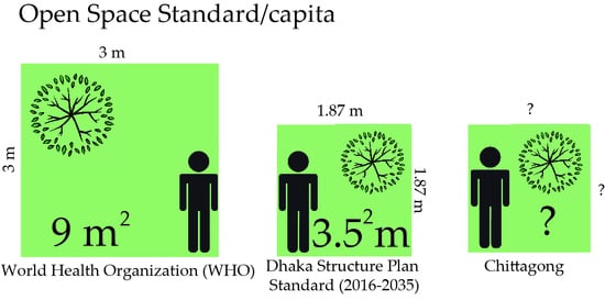
Chittagong has a population of 4.1 million people in 168.1 square kilometers of land. The city is the commercial capital and largest port of Bangladesh and faces rapid urbanization; which has resulted in a loss of the city’s existing open spaces due to the city’s increasing development. An early response to this open space loss came in 1961, when the first regional plan in Chittagong was formulated. This document is of particular importance because it noted, for the first time, the city’s lack of public parks, playgrounds, and small children’s play areas. The plan also proposed 26 new parks and other open spaces to meet the needs of the city’s population. The proposed accumulated area to provide for these spaces consisted of 2935 acres of land, which was largely scattered around the city in small parcels. While cities around the world are struggling to keep a standard amount of open space, the WHO suggested a standard of 9 square meter per capita, the cumulative existing open space in Chittagong is 0.18 square meter per person. Furthermore, the WHO suggested that the availability, accessibility, quality, and security of public green spaces may vary in metropolitan regions, this so-called green environment is one of the indicators of healthy cities [
1]. However, poor cities are far from the international minimum standard set by WHO of 9 square meters open space per city dweller [
2]. The open space standard is to provide sufficient outdoor recreation facilities to the residents of a city. In addition, improved air and water quality, buffering of noise pollution, and mitigation of impacts from extreme events, urban open spaces can reduce environmental health risks associated with urban living [
3]. Open space priorities will be different in different settlement types. These should compensate and complement the physical and social context of the surrounding environment [
4]. As an example, FIT (Field in Trust), the former NFPA (National Playing Fields Association) in Britain fix, started open space standards in 1925 to provide playing facilities to residents according to age group [
5]. Hence, open space standards help to set a well-distributed network of space in a city to serve the resident by placing in proximity. Therefore, open space standards need to be sorted according to local and physical context. In a dense setting, a good standard depends on provision, distribution, accessibility, connectivity, diversity, size, shape, and quality [
6].
Land use change in Chittagong, from open space, vegetation, and waterbodies to urbanized settings occurred from 1989 to 2001 where open areas were reduced by 76%. Then from 2001 to 2013 a further reduction was noted, this time a reduction of these spaces occurred by another 72% [
7]. The implication of this reduction was noted by Hassan (2008), where it was estimated that, in 2006, Chittagong had 132.7 acres of open space that served only 3% of the city’s demand [
8]. Earlier, however, Hossain (2002) attempted to determine the city’s existing open spaces and water body acreage in the 1961 Master Plan of Chittagong City. She found and mentioned that; “[we] currently have an open space average of 0.066 acres per 1000 population, we have failed miserably to promote the development of parks, playfields, and other amenity open spaces needed” [
9]. Unfortunately, this failure appears to be becoming more pronounced as the city’s population grows. Every year, for example, on average, the population inside the city’s area increases by approximately 77,625 people [
10]. Because of this increasing population, to meet the growing demand for open spaces, it can be estimated from Private Housing Rules in Bangladesh that Chittagong will need an additional 0.036 square kilometers of park land and 0.024 square kilometers of playgrounds per person within the city area [
11].
2. Research Objectives and Methodology
The above discussion suggests that Chittagong does not have adequate open space to meet its existing and growing population. In fact, open space is decreasing at an alarming rate and is accompanied by the planning authority’s lack of understanding of the varied open space typologies found in the city. This paper is an attempt to conduct an open space database of Chittagong by analyzing the provision of open space in master plans. Hence, the objectives of this research are:
Develop an understanding of international open space standards to establish relative benchmarks for potential use in Chittagong.
Examine existing formal open space in Chittagong.
Document the existing informal open space areas in Chittagong according to planning direction.
Recommend an approach that can be used to realize open spaces in Chittagong.
By addressing the above objectives this research plans to contribute to the establishment of an open space standard relating to a developing urban setting, which will support the Chittagong’ planning authority in their effort to create and maintain open space in the city. The research will also present an open space typology and model that can be used by other densely populated cities in emerging nations that lack open space infrastructure. In addition, the creation of an open space model will not only suggest an adequate open space benchmark for Chittagong’s residents but can also play a role in addressing issues that affect peoples’ quality of life, health, and safety. Furthermore, the standard will help with the planning of open spaces of different typologies, while the benchmark will help the planner control and preserve open space where necessary.
The methodology used in this research is based on a review of frameworks related to open space benchmarks and typology recommended by organizations, such as the WHO, National Recreation and Park Association (NRPA), and Greenspace Scotland. Following this review, the next section focuses on a theoretical discussion of Chittagong’s existing open spaces and the planning proposals intended to improve the city’s open space situation. Location and topography (height) and their effect on influencing the ‘accessibility’ of open space in Chittagong is discussed using material generated from the city’s GIS database; which has been provided by the Chittagong Development Authority (CDA). Google Maps and Google Earth mapping information related to the City are overlaid onto this GIS material to help illustrate the data. Essentially, the research uses a case study approach, as explained by Yin [
12], to investigate the contextual conditions in a single and extreme case, found in Chittagong city’s open space, by critically examining the master plan for Chittagong.
3. Understanding Open Space Standard
Open space as a ventilation space in a city is a determining factor of the health of the community [
13]. An open space standard includes a needs-based assessment that considers population numbers, density, demographic profiles, and recreation preferences [
14]. The paper focuses on developing an open space standard for Chittagong to compare to the current city standard and how it can make more of what it has. In the context of planning for a city-wide open space agenda, the term standard in reference to open space requirements is referred to, in this instance, as a mechanism to help address change in the City for the betterment of its residents. However, before this reference can be applied it must first be noted that the open space standards used throughout the world are determined by a number of indicators and their use for open space planning has a long history, dating back to the nineteenth century [
15]. Throughout the 20th century, formal national standards for open space planning were developed, notably, in Britain and in the United States [
16]. In Britain the National Playing Fields Association (NPFA), now Fields in Trust (FIT), standard of 6 acres of open space per 1000 population (24 square meter per capita) has been in existence since the 1920s, while in the USA, the National Recreation Association (now National Recreation and Parks Association, NRPA) standard of 10 acres of open space per 1000 population (40 square meter per capita) dated from early in the twentieth century [
16].
What can be assumed by this short ‘list’ of countries and open space examples is that their respective standards reflect a number of specific country related indicators and these vary in relation to their cities. They also reflect the priorities and agendas of local planning bodies. Yet, the most commonly used indicator, in these settings, is a Quantity Standard, which is derived from examination, by city officials, of their open spaces related to a population of 1000 or by square meter per capita. The other standard, quality, is largely overlooked as a mechanism to achieve open space aspirations and address safety and user’s satisfaction. Accessibility is another open space-related standard which is discussed in the next section of this paper to discuss the area of Chittagong that has been deprived from open space facility.
The following table is a conceptual attempt to organize the open space standards used in the countries of America, Australia, Europe, and Asia. This figure should not be viewed as a comprehensive work or for the purposes of criticizing country specific standards. Rather it should be viewed as an illustration suggesting an abstract weighting of a respective country’s standards that affect the realization of open space aspirations in a setting.
Table 1 shows that in the USA and UK, countries measure open space standards by four indicators. These are quantity, quality, accessibility, and neighborhood or locality; whereas in Australian states and territories, only the first three indicators are used. In comparison, Asian countries like Hong Kong and Kuala Lumpur use both quantity and accessibility standards. Whereas, India only uses the quantity indicator to measure open space standard. As the table suggests, there are a range of standards and open space priorities in each of the respective country settings. Each set of standards also appears to follow and is prescribed along a specific cultural context. According to the above table, the following three standards are the most commonly practiced:
Accessibility standard
Quality Standard
Quantity standard
To aid in the discussion of Chittagong’s open space development this paper focuses on examining the accessibility and quantity standard of Chittagong’s existing open spaces. This is done in an attempt to understand the extent to which a shortage of open space is currently occurring in the city. These two indicators (accessibility and quantity) need to be reviewed and focused on as they represent dimensions of the existing open space shortage currently being addressed in the City’s planning proposals and little material is found on these. Other data, for example quality standard, however, does exist, which is on the level of satisfaction of safety and security of parks and playgrounds in Chittagong [
8].
I. Accessibility standard: The accessibility standard refers to how close people should be to their nearest publicly usable open space [
18]. So, accessible green spaces are defined as places available free of cost to the people, and are mainly utilized by target users living in the catchment area [
17]. International research into the impacts of greenspace on health and on wider quality of life shows that having greenspace within a 5-min walk of home is a strong indicator for health and quality of life benefits [
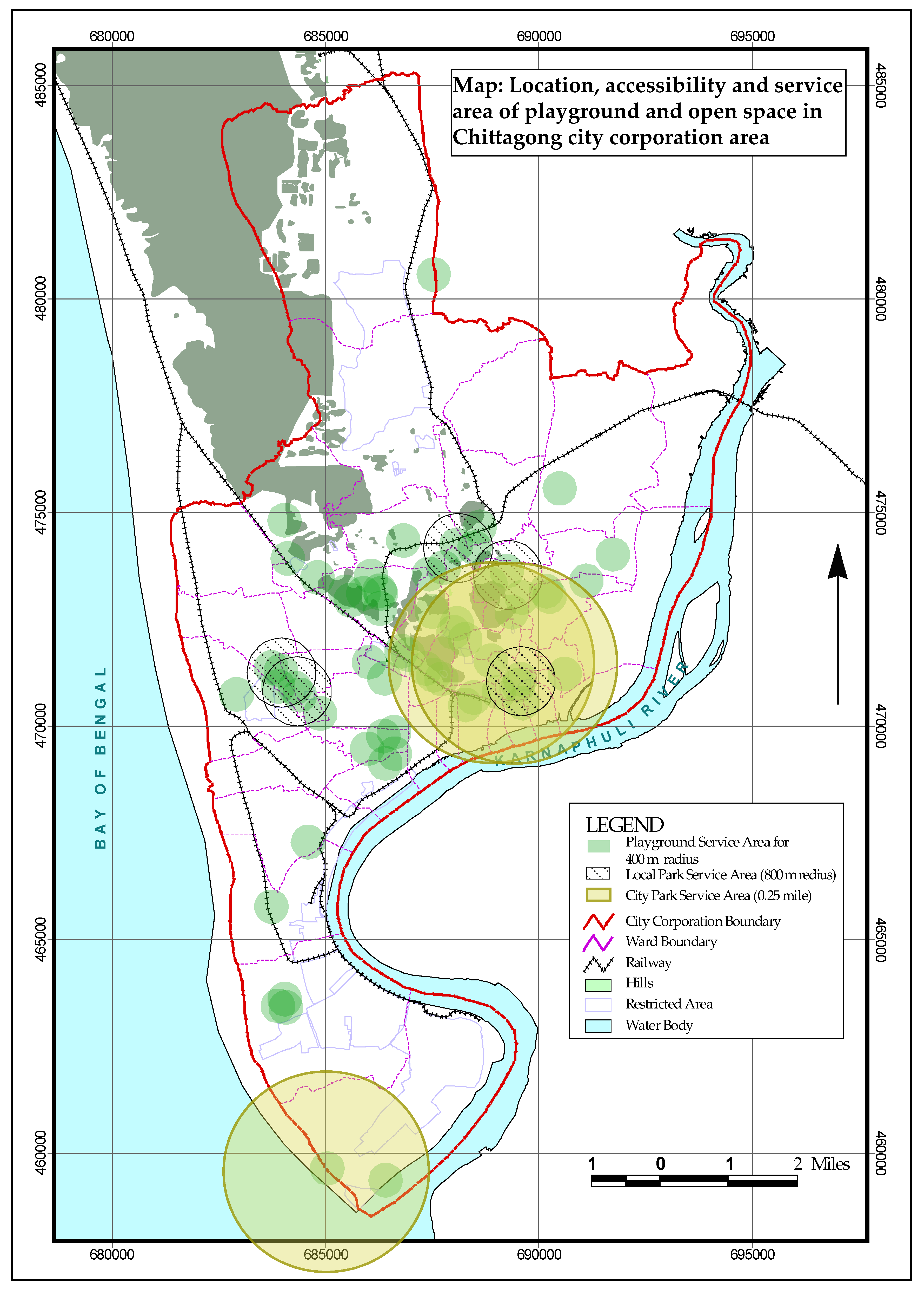
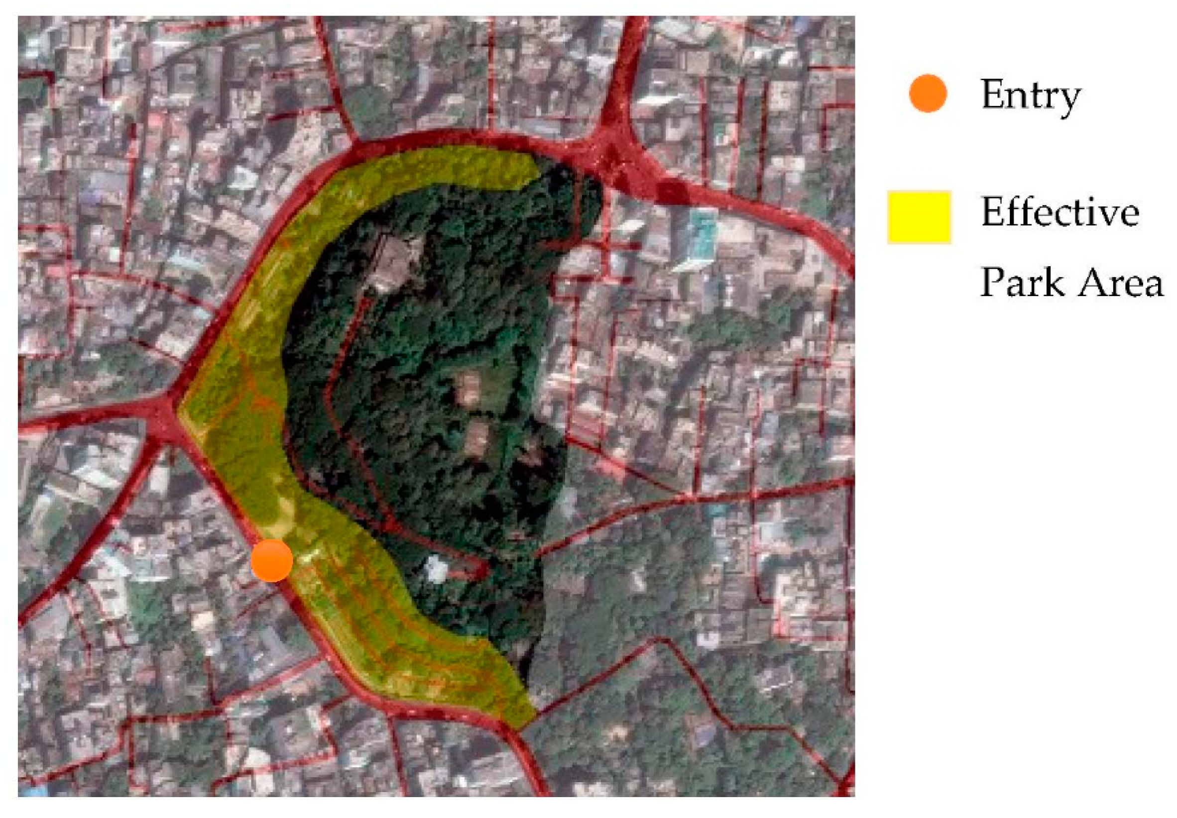
19]. There are several methods developed to measure accessibility. Bangladesh does not have any accessibility standard for Chittagong to follow. But according to walkability of 400 m, the accessibility scenario is as shown in the
Figure 1 (paid and restricted entries are ignored due their accessibility restrictions). The figure shows that the open spaces are mostly concentrated in the old town, but it is a necessity if they are accessible in terms of connectivity to surroundings by walkways.
A total of 69 local parks and playgrounds of Chittagong will have a catchment area. From the equation, area of a circle, this catchment area is × 69 = 34,683,182 square meter or 34.68 square kilometer of land, which is only 20% of the whole city.
II. Quality Standard: The quality standard is a matrix that identifies what infrastructure or landscape features are appropriate and suited for open spaces that satisfy the users [
17]. All publicly usable open spaces score ‘good’ or better on the locally used quality assessment. A report by Hassan (2008) on quality of seven parks and 13 playgrounds shows that the satisfaction levels of Park users are relatively better than Playground users in Chittagong.
III. Quantity Standard: The quantity standard also varies with locality. Quantity is based on existing open space provision. All settlements/neighborhoods should have X hectares of publicly usable open space per 1000 people (or Ym2 per household)—where X or Y is locally derived.
Quantity benchmarks related to the above standards vary in different cities. For example, the majority of councils in Australia apply the open space standard of 7 acres/1000 population or 28 m
2 per capita [
20]. In Chittagong this type of ratio is beyond the consideration of planners because Australian cities (such as Sydney) are suggested to be not as densely populated when compared to European and Asian Cities [
15]. While density is an issue in fixing the open space standard as a physical feature, a comparison of Chittagong and, say, Melbourne may revolve around the respective city’s approximate size (i.e., area), population, and relative density along with clearly stating how/where metropolitan borders are framed and what is included (or not) as open space.
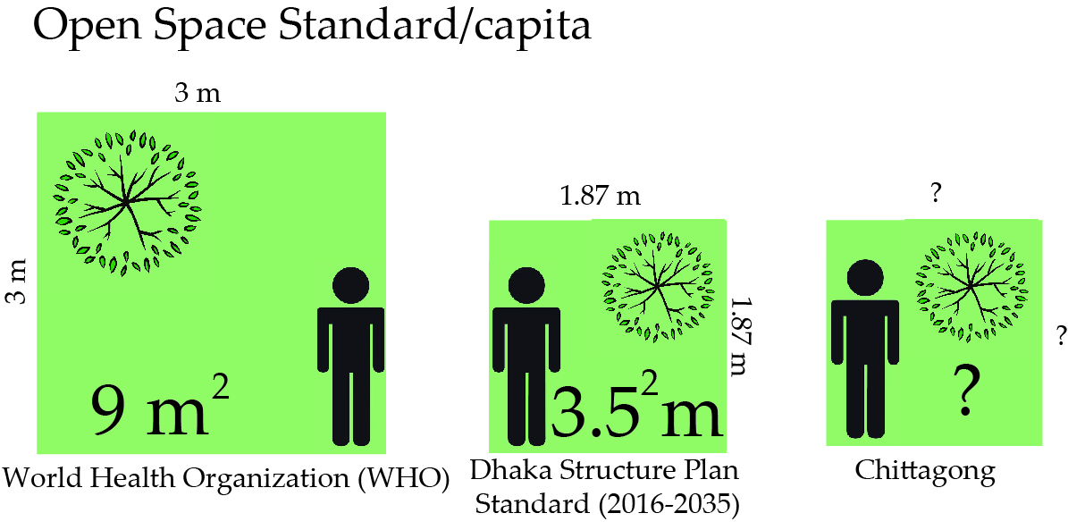
For example, the World Health Organization (WHO) recommends 9 m
2 of open space per person. Cities such as Tokyo, Hong Kong, and Buenos Aires strive to meet this standard (or other open space benchmarks) [
21]. Hence, a standard one size fits all ratio, such as that developed by the WHO, may not be appropriate in setting like Chittagong.
Table 2, below, identifies the relative open space per capita ratio in cities considered to be the fastest growing and most densely populated. The cities considered developing and fast growing according to UN habitat are taken for this comparison [
22]. The UN habitat suggests that Maxico, Buenos Aires in Latin America, Dhaka, and Mumbai in South Asia are developing cities. Istanbul and Kuala Lumpur are also taken into consideration as Turkey and Malaysia are the fastest growing rapid urbanizing countries [
22]. Though China is also a rapidly growing country, the mega cities of China like Beijing and Shanghai have a reasonable area of open space compared to their density. The Chittagong master plan did not propose any standard to follow; Dhaka Structural Plan (2016–2035) can be taken as reference, While Dhaka city has only 0.16 m
2 open space. The table below presents the cities that have an open space ratio below the WHO standard.
4. Existing Open Space Ratio in Chittagong and Its Management
Currently, there are 81 official and unofficial open space areas within Chittagong, and combined, they occupy 325.43 acres of land. These spaces can be categorized into seven different existing open space typologies; which are discussed in the following section.
Table 1 identifies the distribution of open space in the city. Interpreting data from this table suggests that Chittagong has only 0.0476 acres of open space per 1000 people or 0.18 m
2 per person (the amusement parks, zoo, and zoological park is excluded due to paid entry). According to the data in the table, the amount open space related to a Local (municipal) Park is very low; in both number and size. The impact of this is twofold: the city is not providing adequate local open space for its citizens and the residents of Chittagong do not have green space and urban places (e.g., plaza and streets) to realize the openness in a congested setting.
To address the city’s shortage of open space, and in relation to private land ownership and paid entry into open space (e.g., the amusement park identified above), the City’s Detailed Area Plan (DAP) suggests that expropriation and compensation of such land to acquire open space in Chittagong is a strategy worth pursing, as it can help address the city’s loss of ‘green’ space. The document continues to propose the adoption of innovative measures to generate revenue from such lands. However, none of these proposals were implemented. While this plan is being enacted, DAP guidelines on land use must be followed; which accounts for and allows development in privately owned open space. In the hopes of better managing these spaces and other open spaces the DAP has recommended the creation of a department titled: Chittagong Parks and Recreation Department. The intention with the creation of this department is to be incorporated within the Chittagong City Corporation [
4]; who, in itself, maintains a close liaison role with the City’s planning authority which is charged with acquiring, designing, and maintaining parks and open space; while the Master Plan and DAP provide guidelines to preserve unofficial open spaces in the city.
Table 3 also identifies a lean towards quantification rather than quality or accessibility of open space; which in terms of the former data that is easily accessible in the City’s open space related documents.
In relation to the open space areas, identified in the above table, a variety of agencies in Chittagong are responsible for their development and management. In addition to this, regarding the open space planning regime, the CDA and the CCC are largely responsible for the management of the municipal open space systems within the City. The CDA is specifically responsible for planning, conservation, and the implementation of open space. Whereas the CCC is responsible for maintenance of official open space within Chittagong. The management of the City’s waterways and sewage is managed by the District Commissioner’s Office and Chittagong Water supply, and the Swage Authority (CWASA), respectively [
26]. The Bangladesh Navy (BN) and Chittagong Port Authority (CPA) are engaged in riverside open space management, which contributes to the planning and development of the City’s waterfront. The Bangladesh Navy (BN) and Chittagong Port Authority (CPA) are engaged in riverside open space management, which contributes to the planning and development of the City’s waterfront.
To bring these varying open space management organizations together according to the DAP, the city’s planning authority and the CCC/local government are to establish cooperation between private land owners, private developers, companies, the government, environmentalists, and professionals to establish a system of open spaces that is made up of hills, ponds, gardens, walking and cycling paths, and tree-lined boulevards [
10]. In essence, these authorities desire to bring together all the various open space management groups under one umbrella with the intent to plan and coordinate the city’s future open space direction. According to the CCC Ordinance, the Corporation, if required by the government, shall layout and maintain public places as may be necessary for the recreation and convenience of the public, such as those related to public gardens and open spaces.
5. Open Space Planning Standards and for Bangladesh
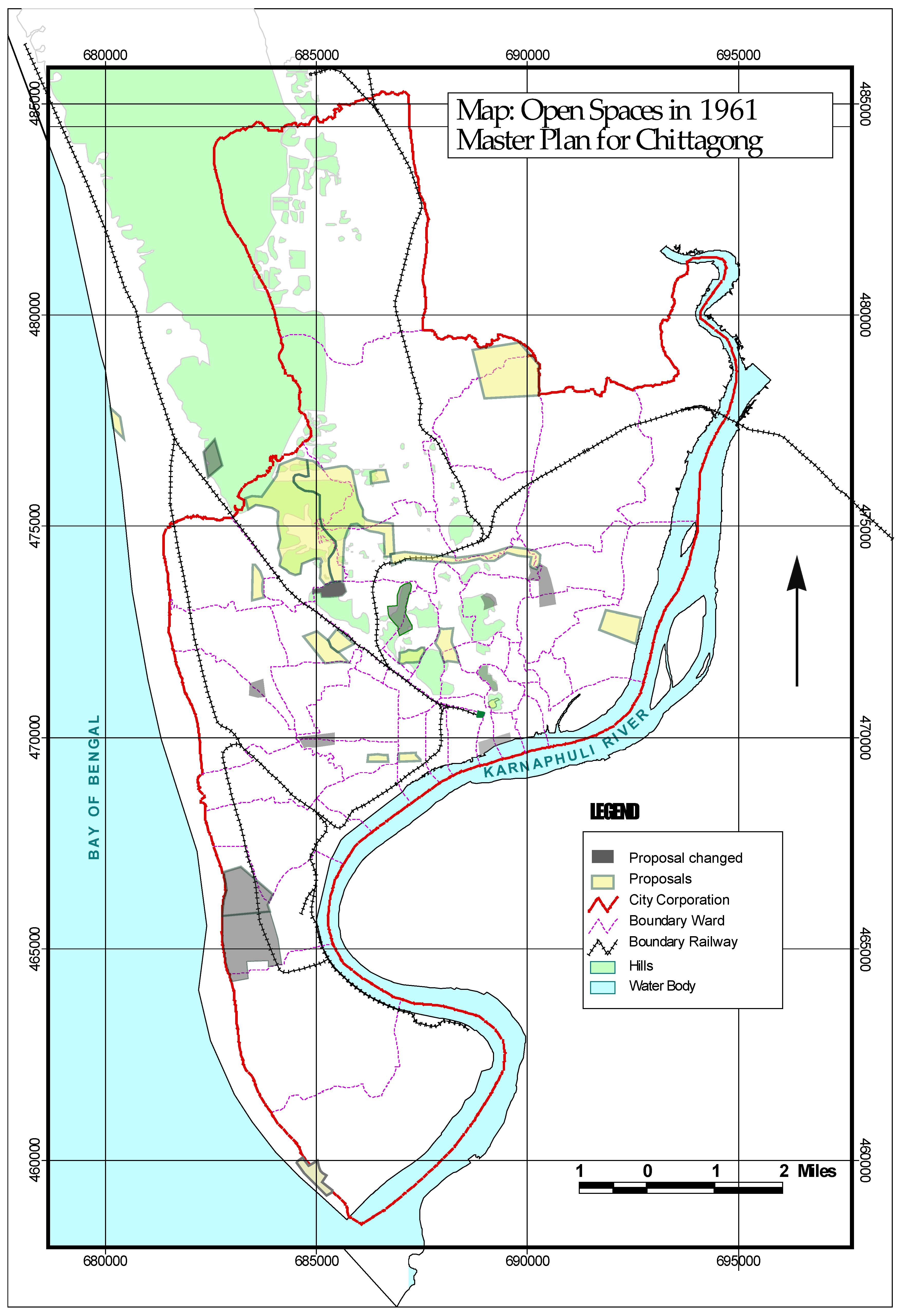
In the 1961 Master Plan for Chittagong, the open space recommendations received negligible attention by the City’s officials [
10]. The recommendation was to increase open space by providing twenty-six proposals which were made by arbitrarily selecting sites to preserve for future need. Later, in 2004, guidelines and a planning standard for parks and playgrounds were established for the City’s Private Housing Projects by the Ministry of Housing and Public Works, Bangladesh. The following standards have been adopted for open spaces for land development rules for private housing and suggest that the City’s natural green areas like City Park, the Botanical Garden, or water bodies are excluded from this structure. The Detailed Area Plan of Chittagong provides guidelines for the conservation of open spaces, while the direction on open space standard and the cumulative figure of existing open space is overlooked in DAP. Chittagong follows the following standards for developing private housing projects under the supervision of the Chittagong Development Authority (CDA). However, these standards relate to, and provide for, open space in private residential areas. The requirements are:
Local Park: 0.12 Acre/1000 people or 0.48 square meter/capita
Playground: 0.08 Acre/1000 people or 0.32 square meter/capita
Total 0.20 Acre/1000 people or 0.80 square meter/capita
Hassan (2008) suggests that an open space standard in Chittagong of 1.8 acre/1000 population or 7.28 square meters per capita would be hard to achieve when the City’s existing open space is currently 0.18 square meters per capita. Additionally, the proposal was also made by taking the suggestion of officials and adding selective Master Plan proposals while ignoring the distribution of typology and accessibility of residents.
Again,
Table 4 shows that the proposed standard of open space in four cities of Bangladesh each fall below the recommended WHO standard. Furthermore, the existing open space ratios identified in these cities are below the recommended standard for open space in Bangladesh. As an example, open space in Dhaka is at a level of 0.16 m
2 per person; which is well below the standard recommended in the city’s master plan. Again, it is noticed that, DMDP (1995–2015) proposed 3.8 m
2/capita open space for park and playground was proposed additional 1.3 m
2/capita, which has been revised in Dhaka Structural Plan (2016–2035) as 3.5 m
2 for both parks and play fields [
27].
In order to help establish a relative target to aspire to in Chittagong over a specific time frame, it is important to review the types of open space found in the City and their association in this setting’s urban catchment areas. Hence, the availability of open space needs to be revisited as this potentially influences the recommendation of open space standards for Chittagong. The following section examines the existing open space scenario in the Chittagong with the view of identifying and cataloging the various open spaces used by the city’s residents by following the typology of open space in cities.
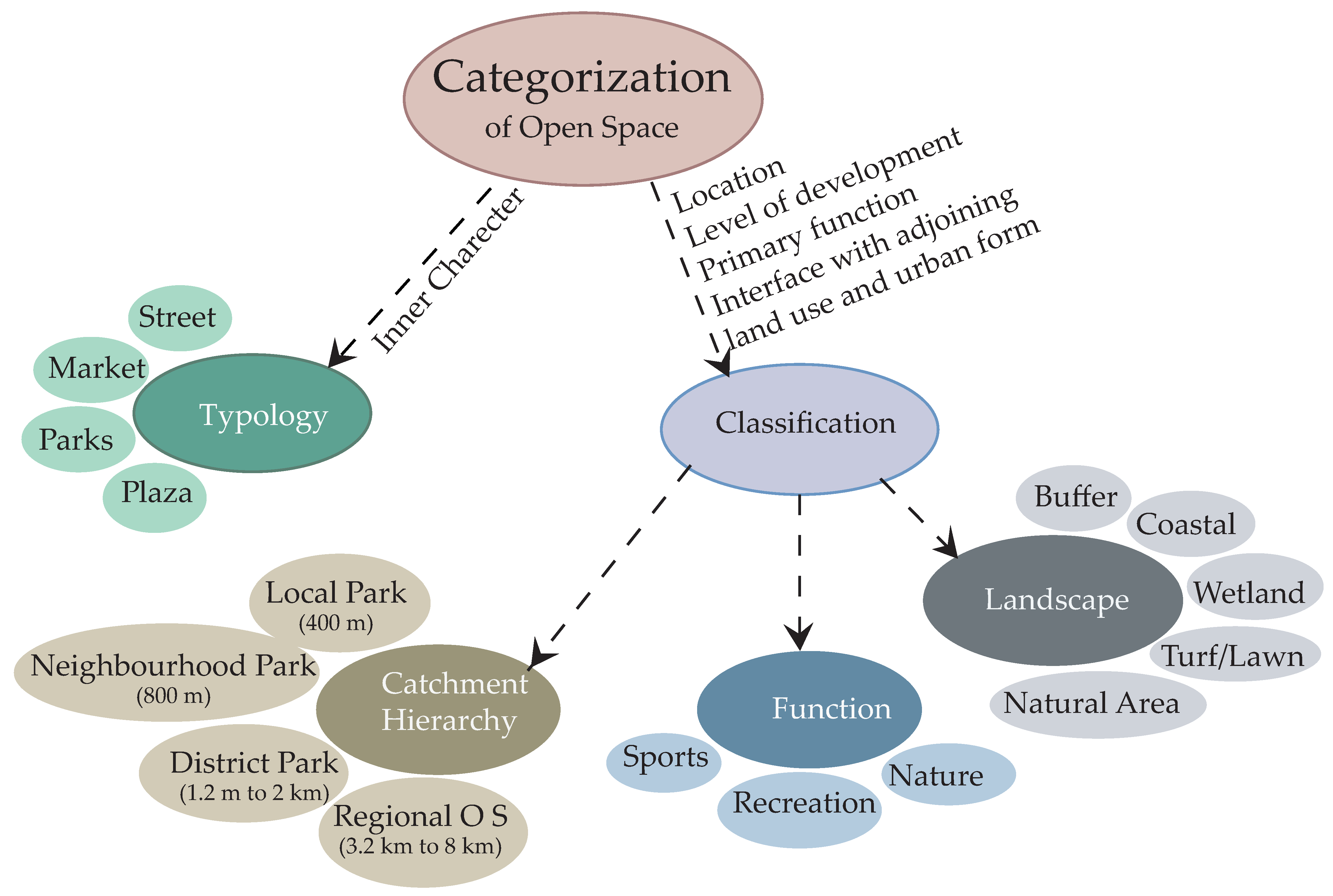
6. Categorization of Open Space
There are generally two methods used in open space categorization i.e., ‘Typology’ and ‘Classification’. Typology refers to the type of open spaces regardless of their inner character. In fact, the typology method mainly focuses on type of spaces such as ‘Squares’ ‘Plazas’, ‘Atrium/Indoor/Marketplaces’, ‘Streets’, ‘Residential’, ‘Parks’, ‘Markets’, and so on [
29]. Open space character is influenced by a range of factors such as location, level of development, primary function, and interface with adjoining land use and urban form [
30].
Classification is used when the characters of spaces are included in the categorization. In addition, open space has different characteristics, and this influences the way in which open space is used and valued [
31]. The classification system is to be applied in conjunction with the ‘Site Analysis and Context Assessment’ and ‘Precinct Objective’. The idea being that the site analysis, context assessment, and precinct objectives will have identified those characteristics of a site, and its surrounds that should be reinforced and those that may pose constraints. The classification method in classifying open spaces generally covers three approaches, (i) the catchment hierarchy (who will use the open space), (ii) function (the role of the open space), and (iii) landscape/environmental character (what the open space looks like) [
32].
Figure 2 shows the inclusive view of open space categorization.
6.1. Function
Each open space is assigned with a functional classification to reflect its primary use, used to define the purpose planned for a space, and a functional classification, considering the primary purpose or use of the open space within the network [
33]. Primary use and expected activities identified three primary functions of open spaces [
32].
Recreation spaces: Recreation spaces provide a setting for informal play and physical activity, relaxation, and social interaction. Recreation spaces enhance physical and mental health through activity that provides relaxation, amusement or stimulation [
32].
Sport spaces: Sport spaces provide a setting for formal structured sporting activities. Sport spaces provide a venue for formal, structured sporting activities such as team competitions, physical skill development, and training [
32].
Nature spaces: Nature spaces provide a setting where people can enjoy nearby nature and protect local biodiversity and natural area values. Nature spaces provide opportunity for low-impact recreational activities, such as walking, cycling, picnicking, playing, watching, or exploring natural features [
32].
6.2. Catchment Hierarchy
This term in some sources is simply so-called hierarchy. Hierarchy is basically determined by the geographical area being serviced (catchment), size, level of use and significance. Rutherford (2013), established four categories of catchment hierarchy. These are:
Local open space: Local open spaces (LOS) are usually small parklands that service the recreation needs of the immediate residential population.
Neighborhood open space: Neighborhood open space (NOS) serves as the recreational and social focus of a community. Residents are attracted by the variety of features and facilities and opportunities to socialize.
District open space: District open space (DOS) is principally designed to provide for organized formal sport. DOS will very likely include substantial recreation space and some nature space. DOS design and function should consider biodiversity principles and environmental management goals. DOS serves several neighborhoods with players and visitors traveling from surrounding districts.
Regional open space: Assist to preserve local biodiversity and natural area values.
6.3. Landscape/Environmental Setting
Each open space is assigned with a landscape/environmental classification that reflects their primary physical setting [
34]. This is a landscape setting type classification, which proposed to assist with the differentiation of sites to specify the types of experiences for planning, management and marketing purposes. These are used where the setting type may not be evident from the functional classification. Landscape character is used to define desirable landscapes and/or vegetation [
31].
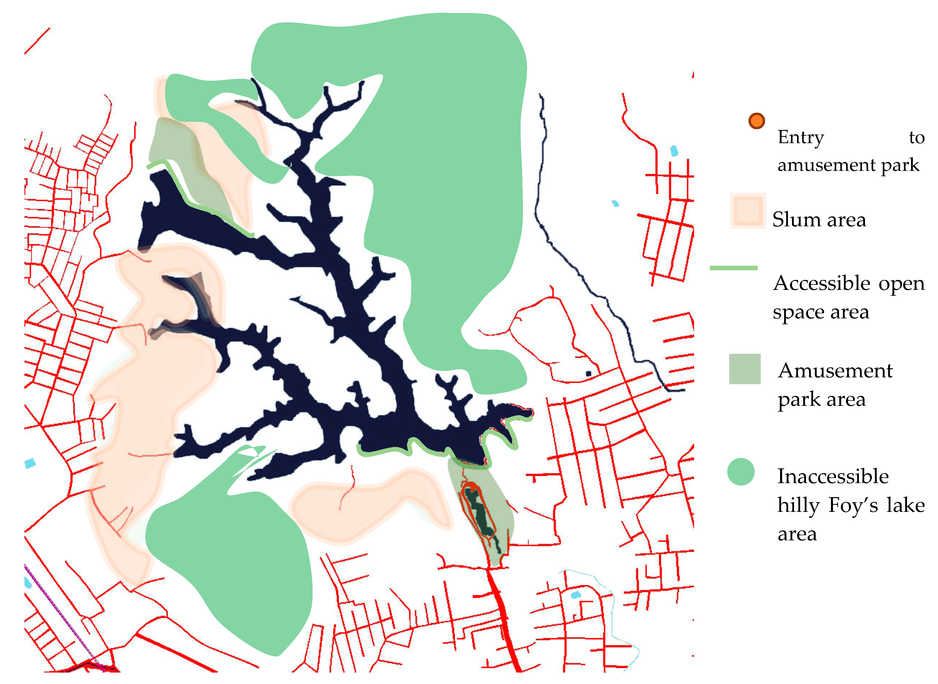
Chittagong has seven types of open space, as described in
Table 1. Among them city park and local park can be categorized as catchment type. Where neighborhood open space, district open space, and regional open space are missing.
Figure 1 showed the catchment area of local parks in Chittagong in term of accessibility. Again, playground and sports centers can be defined as functional open space. In landscape category, Chittagong has coastal areas and natural areas, which will be discussed later.
9. Conclusions
In conclusion, this paper examined the open space scenario in Chittagong and demonstrates that by implementing the City’s master plan proposals gains can be made relative to the City’s existing open space situation. However, only implementing the City’s open space plans will result in a quantitative delivery of land. The desired outcome of achieving net gains will need to be assisted by also preserving the open spaces demarcated in the master plan that are under threat by development. Though the proposals are made on private and different government organizations’ land and the steps recommended in the DAP, a time scale program can be taken for the implementation of these proposals.
The paper found that by simply adhering to the proposed implementation guidelines included in the City’s various master plans, the open space per capita in Chittagong can be increased from 0.18 m
2 to 1.67 m
2. It is understood that this standard is far below those stated by the WHO and that of the country of Bangladesh. However, as Chittagong is bounded by the sea and river to its west and east, respectively, the City can develop more riverfront open space by increasing accessibility, connectivity, and visibility of the waterfront to the City’s dwellers. Hence, more open space can be found and realized by simply looking at the potential of spaces with and adjacent to the City. Lastly, it is suggested that, although the master plan suggestions will increase the ratio of open space in Chittagong, it will still be important to develop distinct guidelines related to open space conservation, land acquisition, and government funding of such open space works. Otherwise, the open space proposals found in the City’s various master plans will continue to fail to meet the Chittagong’s open space needs and not be realized. The article tried to show the proposals on open space in a table (
Table 10). It is recommended to plan the open space of Chittagong more specifically, such as hierarchy type by mentioning area and minimum distance and also by environmental type, which has been found in the literature review. For further direction, it needs to follow the design criteria and process to achieve its goal.
The paper has tried to uphold the possibility to increase open space in Chittagong, mentioning the recommendation of Master Plans and the respective guidelines. The first master plan failed to preserve twenty-six proposals for lack of preservation and conservation guidelines. The 1995 Master Plan and the Detailed Area plan have provided more detail preservation and conservation proposal; which, if followed by the planning body, can help reach the goal of increasing open space. A planned approach to the increase of open space in terms of typology and specified area for each typology will be necessary for residents who have access to open space and can be defined by catchment area. The alarming situation of losing open space that has been predicted can be overcome by documenting the segregated planning proposals.


