
Design of a Corporate SDI in Power Sector Using a Formal Model


Abstract
:1. Introduction
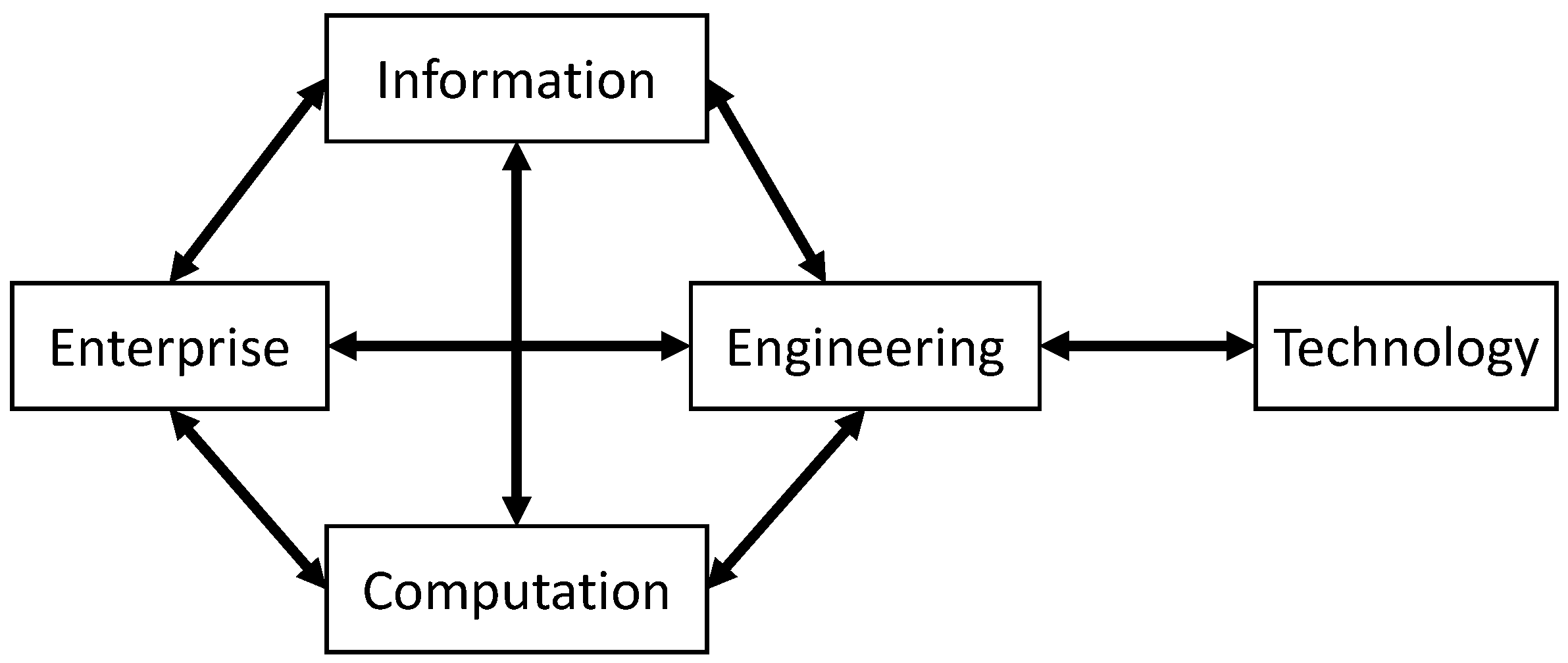
2. RM-ODP Framework
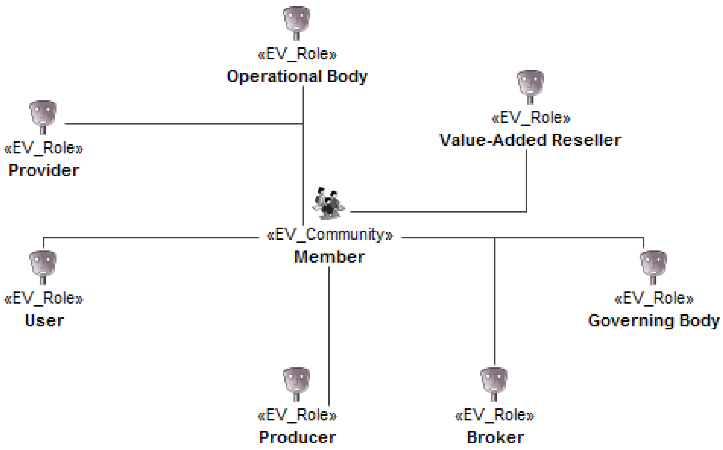
2.1. Enterprise Viewpoint
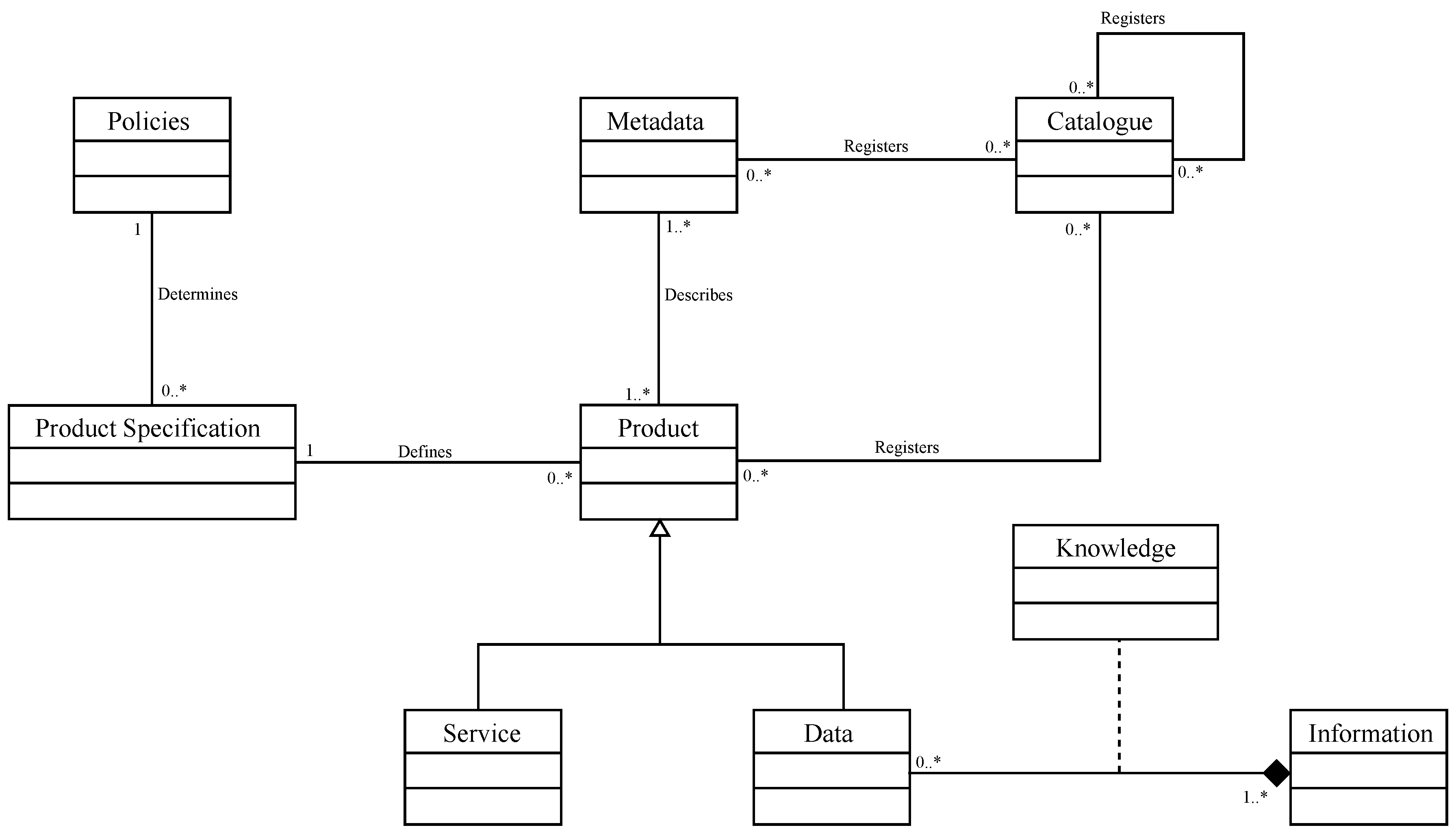
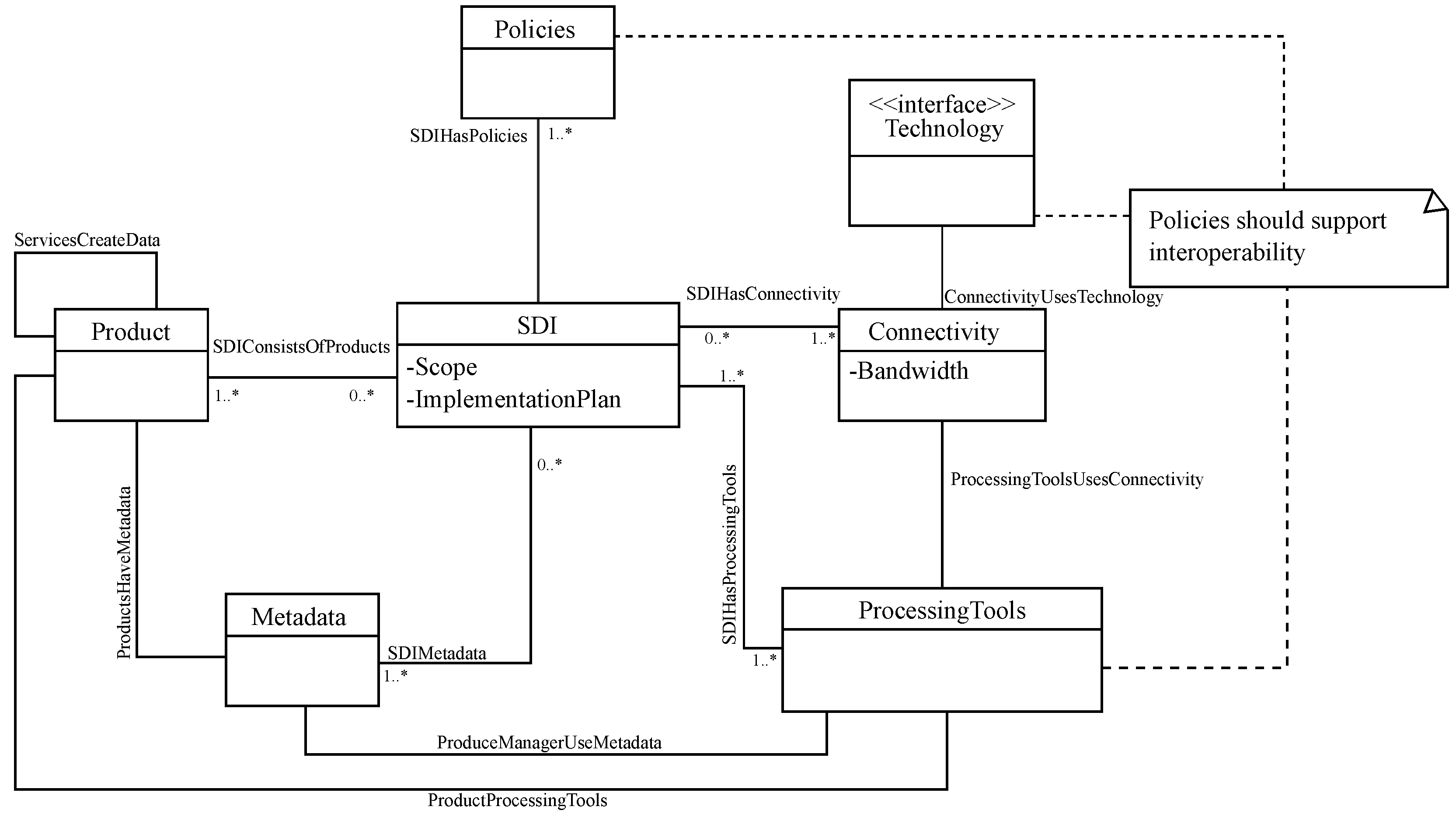
2.2. Information Viewpoint
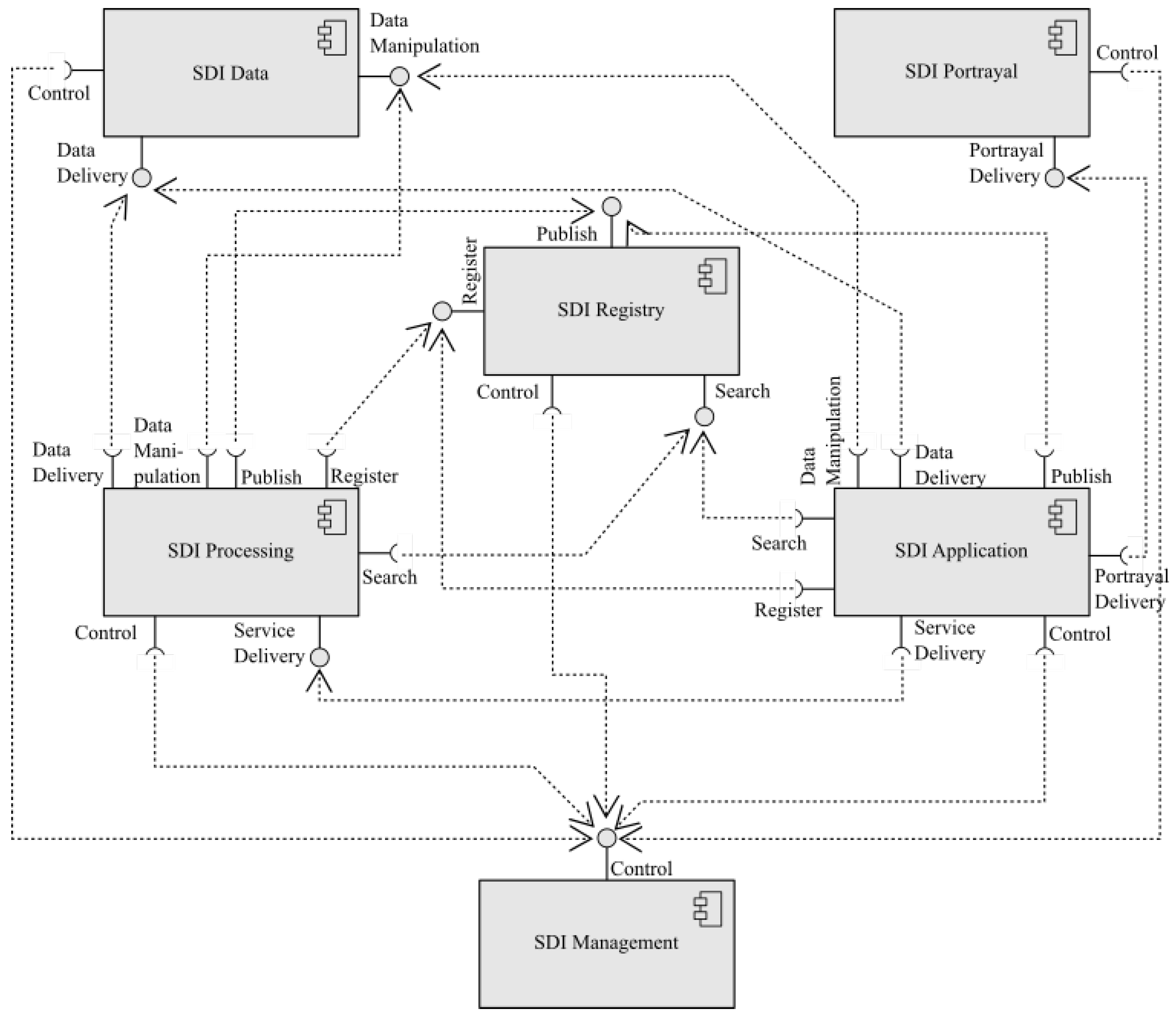
2.3. Computation Viewpoint
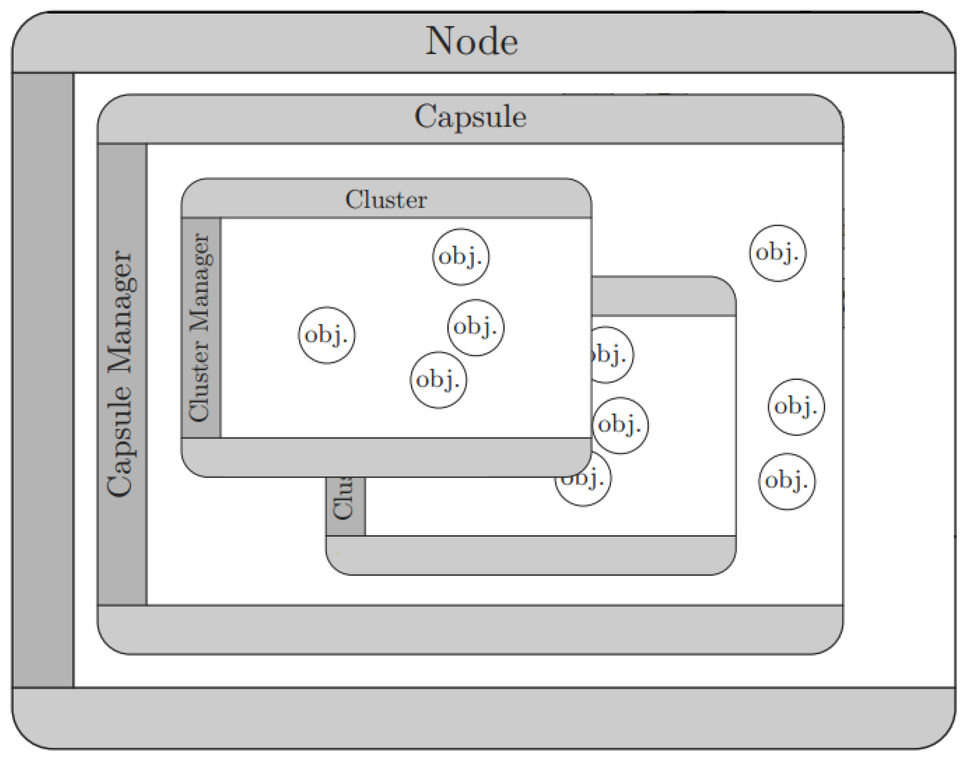
2.4. Engineering Viewpoint
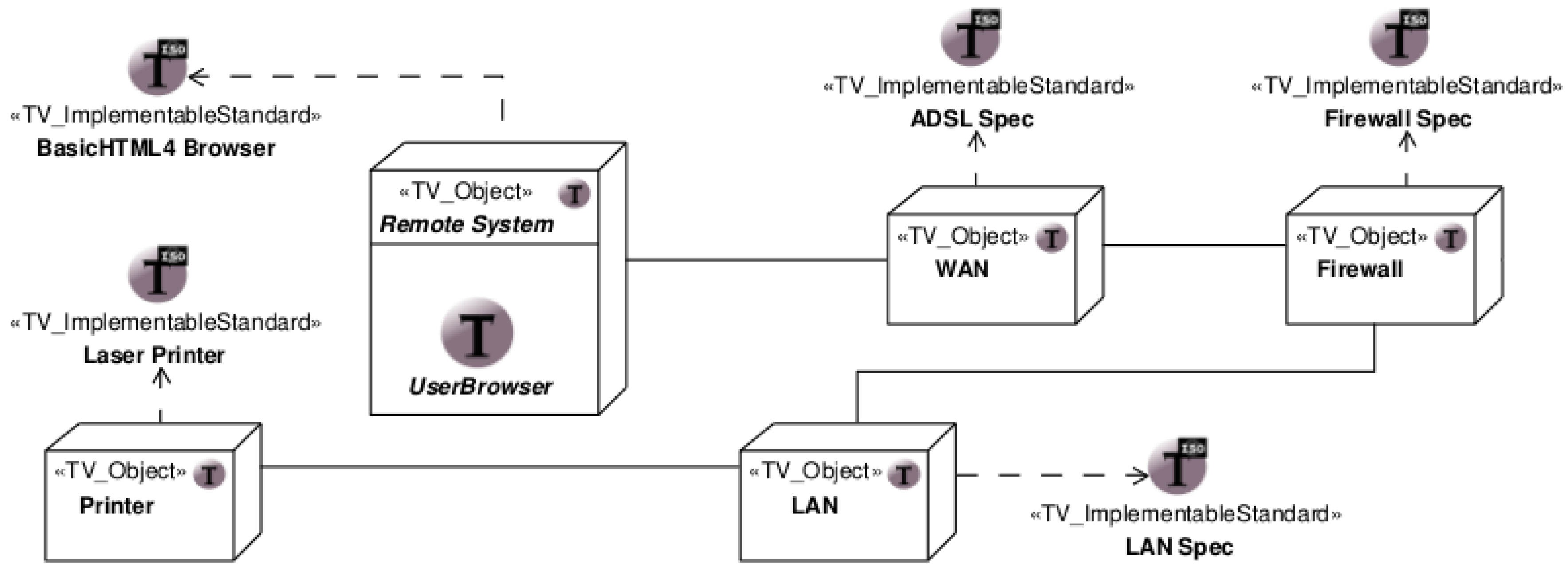
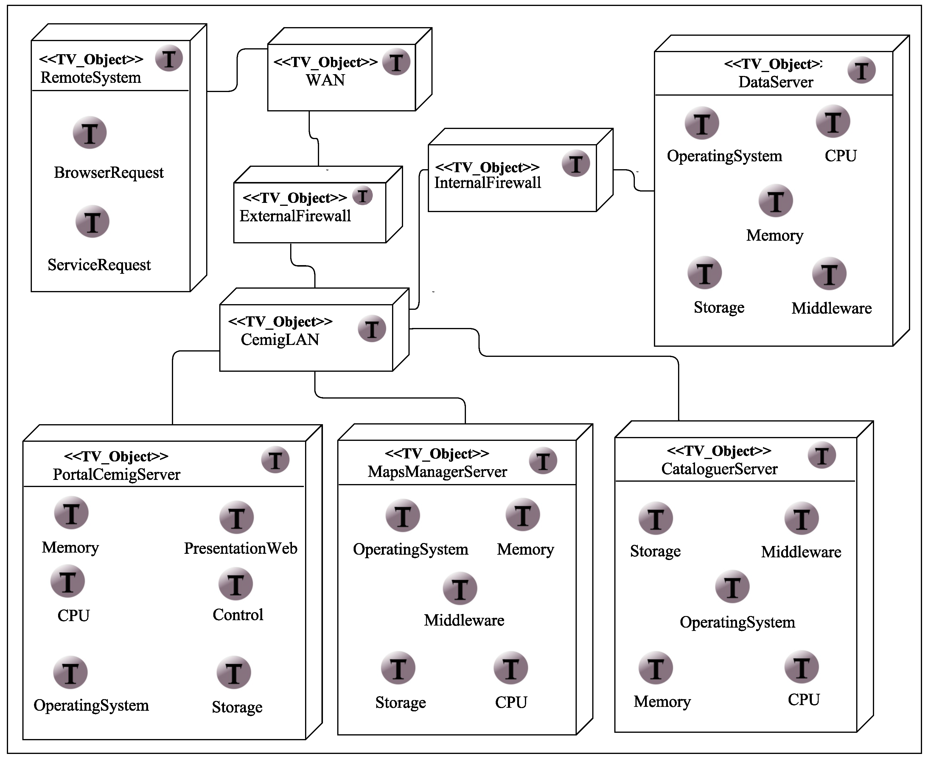
2.5. Technology Viewpoint
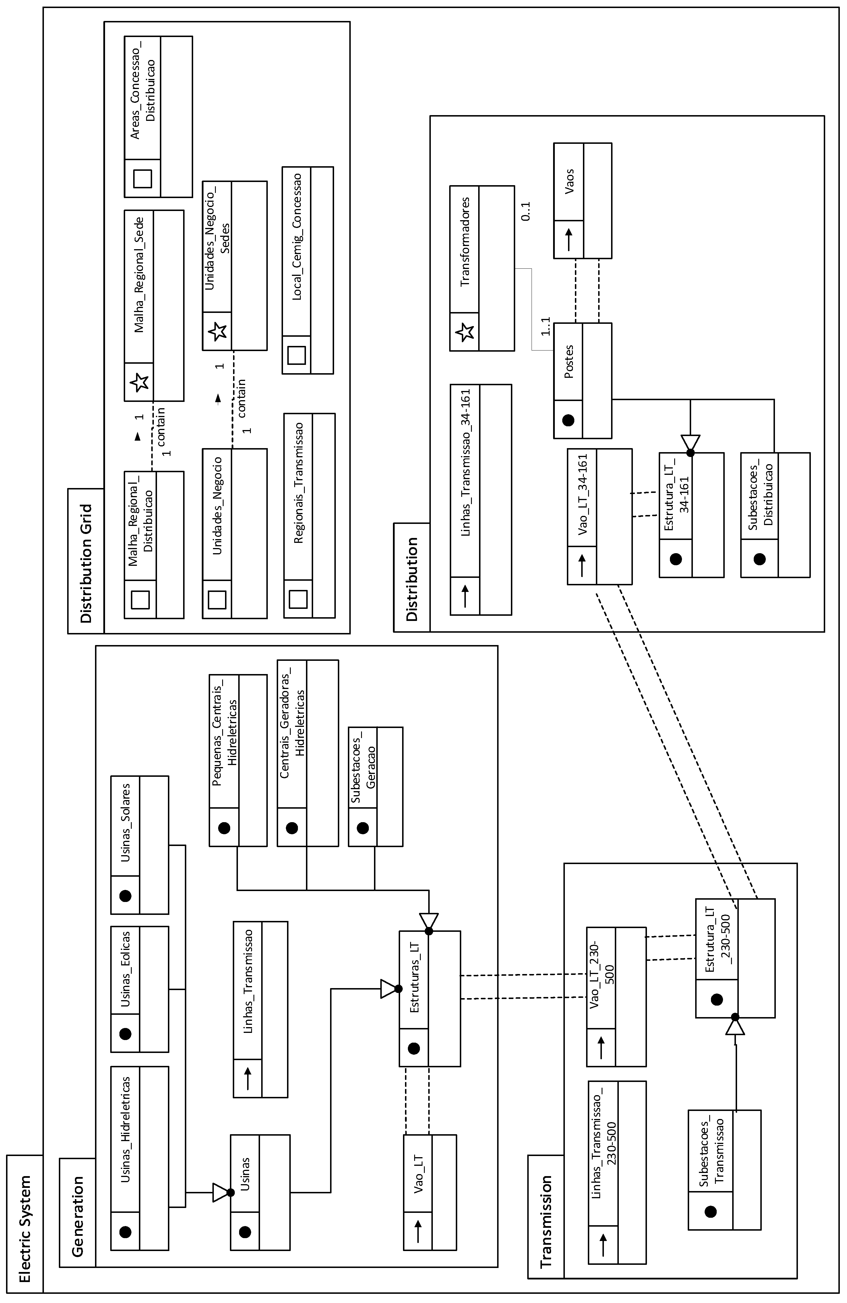
3. SDI-Cemig
3.1. Enterprise Viewpoint
3.1.1. SDI-Cemig Components
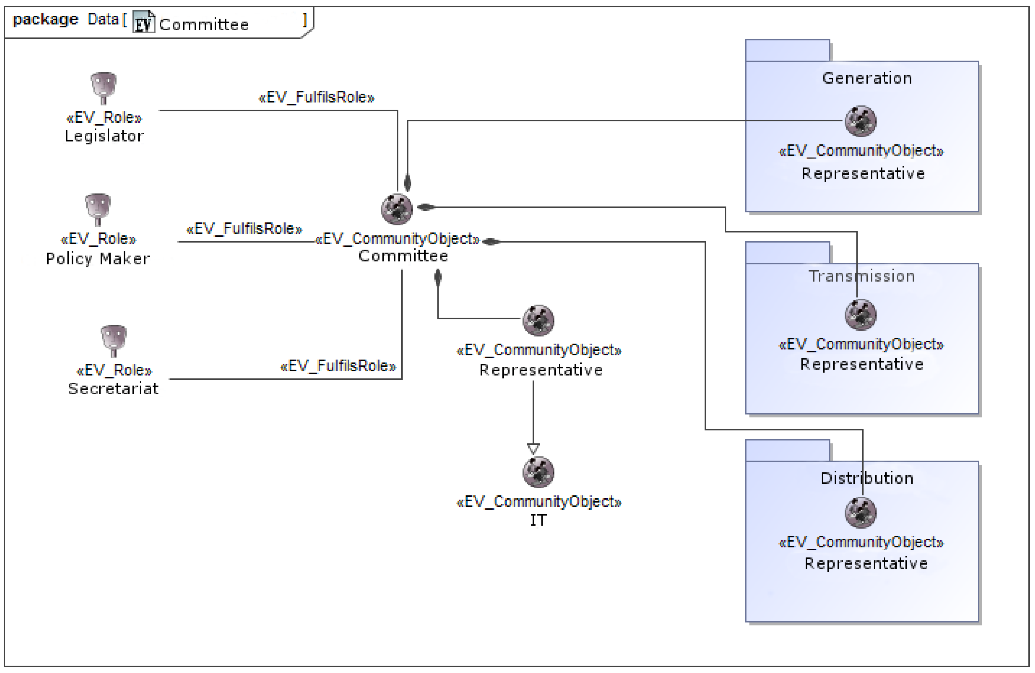
3.1.2. Communities and Their Roles in SDI-Cemig
3.2. Information Viewpoint
3.3. Computation Viewpoint
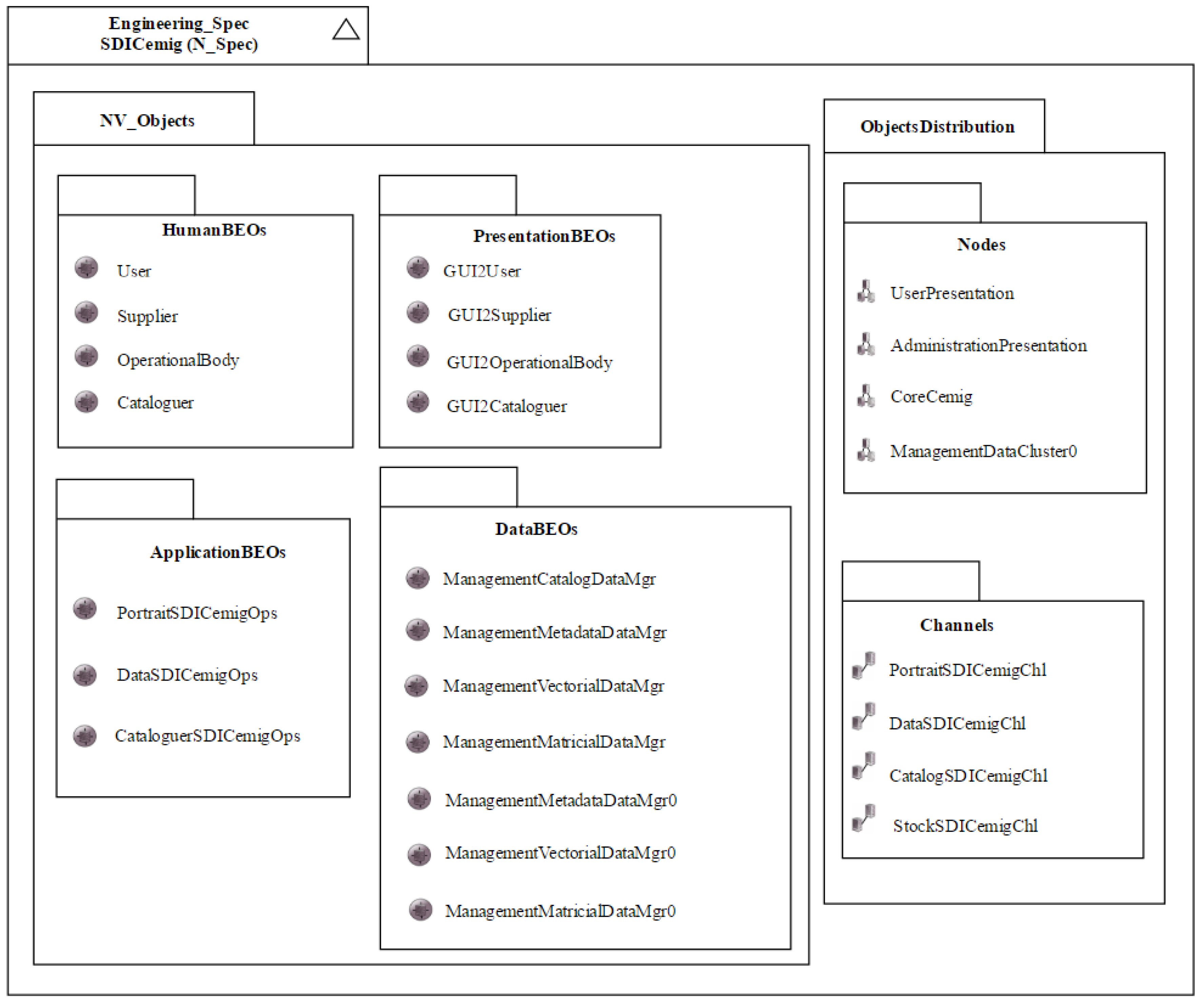
3.4. Engineering Viewpoint
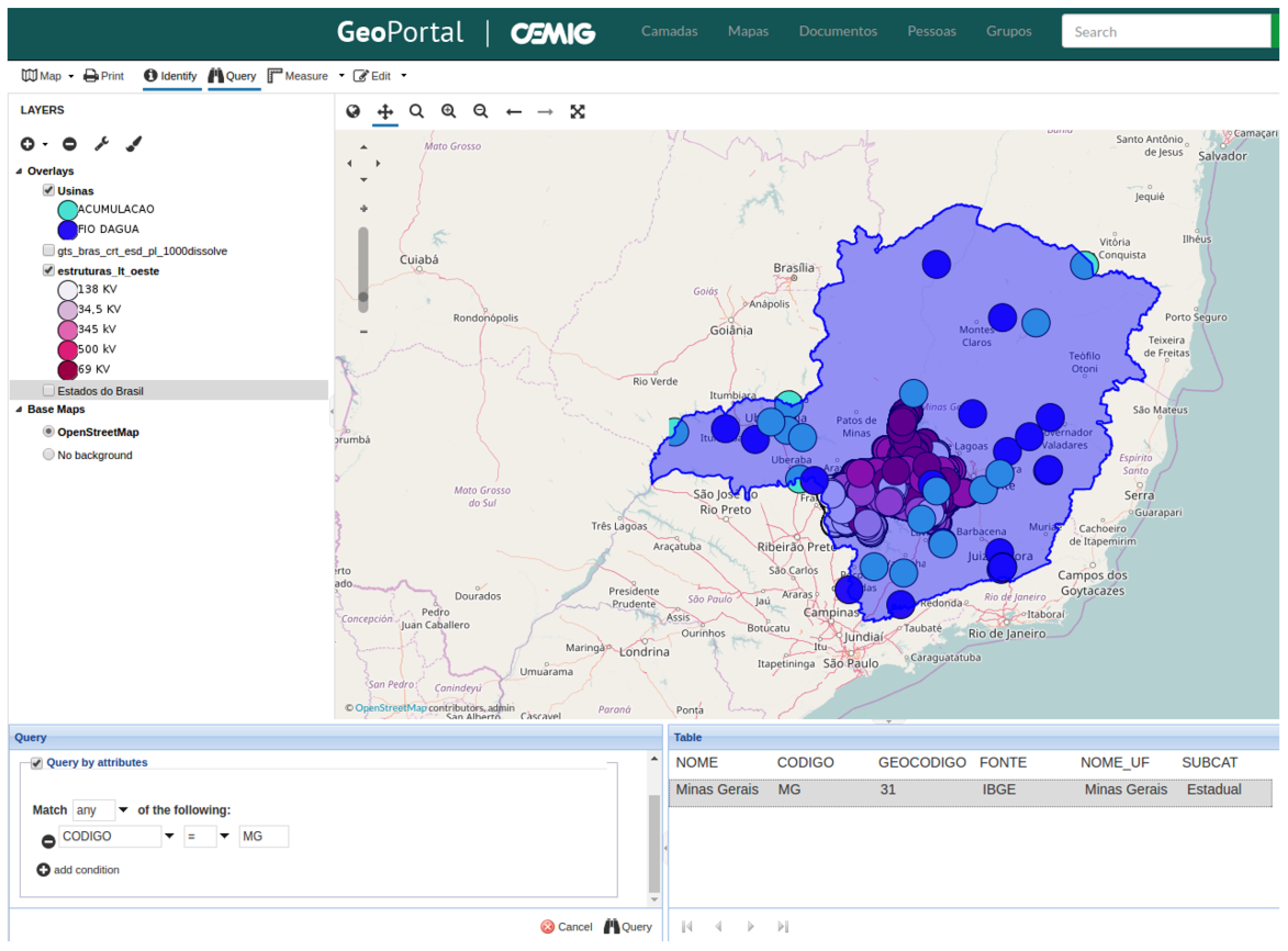
3.5. Technology Viewpoint
4. Related Works
4.1. SDI Description Model for INSPIRE
4.2. SDI Description Model for CGDI
4.3. Use of ICA’s Model to Develop Namibia’s National SDI
4.4. Using ICA’s Model to Specify Ghana’s National SDI
5. Discussion of the Results
6. Conclusions
Acknowledgments
Author Contributions
Conflicts of Interest
References
- Rajabifard, A.; Williamson, I.P. Spatial data infrastructures: Concept, SDI hierarchy and future directions. In Proceedings of the GEOMATICS’80 Conference, Tehran, Iran, 29 April 2001; Volume 10. [Google Scholar]
- Nebert, D.D. Developing Spatial Data Infrastructures: The SDI Cookbook; Technical Report; Global Spatial Data Infrastructure: Orono, ME, USA, 2004; Available online: https://sdi.abudhabi.ae/Sites/SDI/Content/EN/PDFs/sdi-cookbook,property%3Dpdf.pdf (accessed on 18 July 2017).
- Harvey, F.; Iwaniak, A.; Coetzee, S.; Cooper, A.K. SDI past, present and future: A review and status assessment. In Spatially Enabling Government, Industry and Citizens: Research and Development Perspectives; Rajabifard, A., Coleman, D., Eds.; GSDI Association Press: Needham, MA, USA, 2012; Volume 1, pp. 23–38. [Google Scholar]
- Béjar, R.; Latre, M.A.; Nogueras-Iso, J.; Muro-Medrano, P.R.; Zarazaga-Soria, F.J. An RM-ODP enterprise view for spatial data infrastructures. Comput. Stand. Interfaces 2012, 34, 263–272. [Google Scholar] [CrossRef]
- Linington, P.F.; Vallecillo, A.; Tanaka, A.; Milosevic, Z. Building Enterprise Systems with ODP: An Introduction to Open Distributed Processing, 1st ed.; CRC Press: Boca Raton, FL, USA, 2011; p. 284. [Google Scholar]
- Hjelmager, J.; Moellering, H.; Cooper, A.; Delgado, T.; Rajabifard, A.; Rapant, P.; Danko, D.; Huet, M.; Laurent, D.; Aalders, H.; et al. An initial formal model for spatial data infrastructures. Int. J. Geogr. Inf. Sci. 2008, 22, 1295–1309. [Google Scholar] [CrossRef]
- Cooper, A.K.; Moellering, H.; Hjelmager, J.; Rapant, P.; Delgado, T.; Laurent, D.; Coetzee, S.; Danko, D.M.; Düren, U.; Iwaniak, A.; et al. A spatial data infrastructure model from the computational viewpoint. Int. J. Geogr. Inf. Sci. 2013, 27, 1133–1151. [Google Scholar] [CrossRef]
- Cooper, A.K.; Rapant, P.; Hjelmager, J.; Laurent, D.; Iwaniak, A.; Coetzee, S.; Moellering, H.; Düren, U. Extending the formal model of a spatial data infrastructure to include volunteered geographical information. In Proceedings of the International Cartographic Conference (ICC), Paris, France, 4–8 July 2011. [Google Scholar]
- Oliveira, I.L.; Lisboa-Filho, J. A spatial data infrastructure review sorting the actors and policies from enterprise viewpoint. In Proceedings of the International Conference on Enterprise Information Systems (ICEIS), Barcelona, Spain, 27–30 April 2015; Teniente, E., Maciaszek, L., Hammoudi, S., Eds.; SciTePress: Setúbal, Portugal, 2015; Volume 2, pp. 287–294. [Google Scholar]
- Farooqui, K.; Logrippo, L.; de Meer, J. The ISO reference model for open distributed processing: An introduction. Comput. Netw. ISDN 1995, 27, 1215–1229. [Google Scholar] [CrossRef]
- ISO/IEC-10746-1:1998. Information Technology—Open Distributed Processing—Reference Model: Overview; International Organization for Standardization/International Electrotechnical Commission: Geneva, Switzerland, 1998.
- ISO/IEC-10746-2:2009. Information Technology—Open Distributed Processing—Reference Model: Foundations; International Organization for Standardization/International Electrotechnical Commission: Geneva, Switzerland, 2009.
- ISO/IEC-10746-3:2009. Information Technology—Open Distributed Processing—Reference Model: Architecture; International Organization for Standardization/International Electrotechnical Commission: Geneva, Switzerland, 2009.
- ISO/IEC-10746-4:1998. Information Technology—Open Distributed Processing—Reference Model: Architectural Semantics; International Organization for Standardization/International Electrotechnical Commission: Geneva, Switzerland, 2009.
- Oliveira, I.L.; Lisboa-Filho, J.; Moura, C.A.; Silva, A.G. Specifying the Computation viewpoints for a corporate Spatial Data Infrastructure using ICA’s formal model. In Proceedings of the International Conference on Computational Science and Its Applications (ICCSA), Beijing, China, 4–7 July 2016; LNCS 9788—Part III. Springer: Berlin/Heidelberg, Germany, 2016; pp. 275–289. [Google Scholar]
- Putman, J.R.; Boehm, B.W. Open Distribution Software Architecture Using RM-ODP; Prentice Hall PTR: Upper Saddle River, NJ, USA, 2000; p. 834. [Google Scholar]
- Becerra, J.L.R.; Garcia, E., Jr.; Tanomaru, N.; Moraes, D.N.; Ferreira, C.L.P.; Cruz, P.F. Arquitetura de um middleware corporativo na Companhia de Transmissão de Energia Elétrica Paulista. In Proceedings of the Congresso Nacional de Automação Industrial (CONAI), São Paulo, Brazil, 15–18 July 2002; Volume 7, pp. 15–18. (In Portuguese). [Google Scholar]
- Raymond, K. Reference model of open distributed processing (RM-ODP): Introduction. In International Federation for Information Processing (IFIP); Raymond, K., Armstrong, L., Eds.; Springer: Boston, MA, USA, 1995; pp. 3–14. [Google Scholar]
- Wnuk, K.; Runeson, P.; Lantz, M.; Weijden, O. Bridges and barriers to hardware-dependent software ecosystem participation—A case study. Inf. Softw. Technol. 2014, 56, 1493–1507. [Google Scholar] [CrossRef]
- CEMG-CONCAR. Perfil de Metadados Geoespaciais do Brasil (Perfil MGB); Technical Report; Comitê de Estruturação de Metadados Geoespaciais/Comissão Nacional de Cartografia: Brasília, Brazil, 2011. (In Portuguese)
- Portele, C. OpenGIS Geography Markup Language (GML) Enconding Standard; OGC—Open Geospatial Consortium Inc.: Wayland, MA, USA, 2007; Available online: http://portal.opengeospatial.org/files/?artifact_id=20509 (accessed on 18 July 2017).
- Leão, R. GTD—Geração, Transmissão e Distribuição de Energia Elétrica; Technical Report; Federal University of Ceará: Fortaleza, Brazil, 2009. (In Portuguese) [Google Scholar]
- Borges, K.A.V.; Davis, C.A., Jr.; Laender, A.H.F. Modelagem conceitual de dados geográficos. In Bancos de Dados Geográficos, 1st ed.; Casanova, M., Câmara, G., Davis, C., Jr., Vinhas, L., Queiroz, G.R., Eds.; MundoGEO: Curitiba, Brazil, 2005; Volume 1, pp. 93–146. (In Portuguese) [Google Scholar]
- Oliveira, I.L.; Lisboa-Filho, J.; Moura, C.A.; Silva, A.G. Especifying the enterprise and information viewpoints for a corporate spatial data infrastructure using ICA’s formal model. In Proceedings of the International Conference on Enterprise Information Systems (ICEIS), Roma, Italy, 25–28 April 2016; Cordeiro, J., Maciaszek, L., Missikoff, M.M., Camp, O., Hammoudi, S., Eds.; SciTePress: Lisboa, Portugal, 2016; Volume 1, pp. 271–282. [Google Scholar]
- Torres, R.M.; Oliveira, I.L.; Lisboa-Filho, J.; Moura, C.A.; Silva, A.G. Specifying the engineering viewpoint of ICA’s formal model in a corporate spatial data infrastructure. In Proceedings of the International Conference on Advanced Geographic Information Systems, Applications, and Services (Geoprocessing), Nice, France, 19–23 March 2017; Rückemann, C.P., Braz, F.J., Eds.; Curran Associates, Inc.: Red Hook, NY, USA, 2017; pp. 110–116. [Google Scholar]
- Alves, A.R.; Gamero, P.; Peres, C.R.O.; Oliveira, I.L.; Lisboa-Filho, J.; Gonzalez, R. Plano de Implantação da Infraestrutura de Dados Espaciais—IDE; Technical Report; Federal University of Viçosa, Department of Informatics: Viçosa, MG, Brazil, 2016. (In Portuguese) [Google Scholar]
- Fonseca, F.J.B.; Pereira, L.V.S.; Lisboa-Filho, J.; Alves, A.R. Comparing Web GIS systems for display and processing geographic information in the context of INDE. In Proceedings of the IEEE 11th Iberian Conference on Information Systems and Technologies (CISTI), Las Palmas, Spain, 15–18 June 2016; pp. 1–6. [Google Scholar]
- Ellis, R.A.; Lubbers, C.E.; Malan, S.J.; Rivera, P.; Snyder, S.; Thiel, D.W.; Wells, R.B. Method and Apparatus for Preserving Data Integrity in a Multiple Disk Raid Organized Storage System. U.S. Patent 5,504,858 A, 2 April 1996. [Google Scholar]
- Torres, R.M.; Oliveira, I.L.; Lisboa-Filho, J.; Moura, C.A.; Silva, A.G. Specifying the technology viewpoint for a Corporate Spatial Data Infrastructure using ICA’s formal model. In Proceedings of the International Conference on Enterprise Information Systems (ICEIS), Porto, Portugal, 26–29 April 2017; Filipe, J., Smialek, M., Camp, O., Hammoudi, S., Eds.; SciTePress: Lisboa, Portugal, 2017; pp. 333–340. [Google Scholar]
- INSPIRE Directive. Directive 2007/2/EC of the European Parliament and of the Council of 14 March 2007 Establishing an Infrastructure for Spatial Information in the European Community (INSPIRE); Published in the official Journal on the 25th April; INSPIRE—Infrastructure for Spatial Information in Europe: Brussels, Belgium, 2007. [Google Scholar]
- Sjoukema, J.W.; Bregt, A.; Crompvoets, J. Evolving spatial data infrastructures and the role of adaptive governance. ISPRS Int. J. Geo-Inf. 2017, 6, 254. [Google Scholar] [CrossRef]
- Team NSD. INSPIRE Network Services Architecture; Technical Report; INSPIRE—Infrastructure for Spatial Information in Europe: Brussels, Belgium, 2008. [Google Scholar]
- GeoConnections. Canadian Geospatial Data Infrastructure Architecture Description; Natural Resources Canada: Ottawa, ON, Canada, 2005. [Google Scholar]
- ISO/TC211. Geographic Information/Geomatics; International Organization for Standardization/Technical Committees: Geneva, Switzerland, 1994. [Google Scholar]
- Sinvula, K.M.; Coetzee, S.; Cooper, A.K.; Hipondoka, M. Exploring the potential suitability of an SDI model in context of the National Spatial Data Infrastructure (NSDI) of Namibia. In Proceedings of the Ukubuzana Conference of Geographical Information Systems of South African (GISSA), Kempton Park, South African, 2–4 October 2012. [Google Scholar]
- Sinvula, K.M.; Coetzee, S.; Cooper, A.K.; Nangolo, E.; Owusu-Banahene, W.; Rautenbach, V.; Hipondoka, M. A contextual ICA stakeholder model approach for the Namibian spatial data infrastructure (NamSDI). In Cartography from Pole to Pole; Buchroithner, M., Prechtel, N., Burghardt, D., Eds.; Springer: Berlin/Heidelberg, Germany, 2014; pp. 381–394. [Google Scholar]
- Gils, H.V. Web-based biodiversity geodatabases for environmental assessment in mid-income Namibia. In Proceedings of the IAIA15 Conference Proceedings 35th Annual Conference of the International Association for Impact Assessment, Florence, Italy, 20–23 April 2015; p. 5. [Google Scholar]
- Owusu-Banahene, W.; Mensah, F.; Coetzee, S.; Cooper, A.K.; Rautenbach, V.; Sinvula, K.M.; Nangolo, E.; Hippondoka, M. A description of spatial data infrastructure stakeholders in Ghana using the ICA model. In Spatial Enablement in Support of Economic Development and Poverty Reduction; Onsrud, H., Rajabifard, A., Eds.; GSDI Association Press: Needham, MA, USA, 2013; pp. 63–84. [Google Scholar]


© 2017 by the authors. Licensee MDPI, Basel, Switzerland. This article is an open access article distributed under the terms and conditions of the Creative Commons Attribution (CC BY) license (http://creativecommons.org/licenses/by/4.0/).
Share and Cite
Oliveira, I.L.; Câmara, J.H.S.; Torres, R.M.; Lisboa-Filho, J. Design of a Corporate SDI in Power Sector Using a Formal Model. Infrastructures 2017, 2, 18. https://doi.org/10.3390/infrastructures2040018
Oliveira IL, Câmara JHS, Torres RM, Lisboa-Filho J. Design of a Corporate SDI in Power Sector Using a Formal Model. Infrastructures. 2017; 2(4):18. https://doi.org/10.3390/infrastructures2040018
Chicago/Turabian StyleOliveira, Italo L., Jean H. S. Câmara, Rubens M. Torres, and Jugurta Lisboa-Filho. 2017. "Design of a Corporate SDI in Power Sector Using a Formal Model" Infrastructures 2, no. 4: 18. https://doi.org/10.3390/infrastructures2040018
APA StyleOliveira, I. L., Câmara, J. H. S., Torres, R. M., & Lisboa-Filho, J. (2017). Design of a Corporate SDI in Power Sector Using a Formal Model. Infrastructures, 2(4), 18. https://doi.org/10.3390/infrastructures2040018