Article

West Bay Business District in Doha, State of Qatar: Envisioning a Vibrant Transit-Oriented Development

1
Department of Architecture and Urban Planning, Qatar University, Doha 3263, Qatar
2
Department of English Literature and Linguistics, Qatar University, Doha 2713, Qatar
*
Author to whom correspondence should be addressed.
Designs 2021, 5(2), 33; https://doi.org/10.3390/designs5020033
Submission received: 12 April 2021 / Revised: 17 May 2021 / Accepted: 18 May 2021 / Published: 25 May 2021
(This article belongs to the Special Issue Sustainable and Conventional Buildings)

Abstract

:
In recent decades, Doha, the capital of Qatar, has experienced a large-scale transformation due to globalization and rapid economic growth. Recently, these changes have led to a focus on infrastructural development and the launch of the city’s metro project, whose success will depend heavily on Transit-Oriented Development (TOD). TOD focuses on the “3Ds” principles—design, density, and diversity—aiming to create walkable neighborhoods and well-integrated public transportation, with diverse mixed land uses and high-density, sustainable growth. In combining the concepts of livability, sustainable urbanism, and urban sociology, TOD leads to the creation of vibrant and active neighborhoods. The present research project focuses on TOD around Doha’s West Bay metro station, using the city’s central business district as a case study. The aim of this research project is to investigate the existing site conditions of the West Bay area, evaluate them with respect to TOD principles, and then propose a master plan for improved development. The final product of the research project is a proposal with design guidelines that are aimed at increasing the ridership of the West Bay metro station and creating a more attractive and dynamic neighborhood.

1. Introduction

In the past three decades, Doha, which is the capital of the State of Qatar, has undergone massive changes due to rapid economic development; these changes include demographic growth, urban expansion, sporting mega-events, and globalization. Along with its obvious benefits, this rapid growth has led to a number of problems and challenges: urban sprawl, traffic congestion, air pollution, deficiencies in the built environment, and a general lack of affordable housing [1]. Efforts to resolve such problems in urban areas worldwide have led to a movement toward public transportation and Transit-Oriented Development (TOD) as tools for sustainable development. In recent years, government authorities in Qatar have invested in large-scale transit development throughout the country, with a particular focus on the city of Doha. This includes the Doha metro project, long-distance rail, Bus Rapid Transit (BRT), and the Light Rail Train (LRT). TOD development is a crucial component of Doha’s urban planning strategy, through which activities in the vicinity of metro stations are clustered in mixed-use developments, which lead to walkable neighborhoods and less reliance on cars, in turn reducing traffic congestion and air pollution [2,3,4,5].
The main design principles of TOD are known as the “3Ds”, which refer to the design, density, and diversity of land uses around transport hubs, such as metro stations [6,7,8]. The successful integration of transportation systems with land use is the key factor needed for the success of TOD, as this leads to reduced car reliance and increased public transit (PT) ridership. The international experience with TODs has shown that such integration creates economic incentives in the area surrounding such hubs, increasing the land value there [8,9,10,11].
Successful TOD does not occur by accident, and urban design for the area around a given metro station is required before and during the commencement of station operation. This requires careful consideration of the built environment around the station, with an eye toward high-density, mixed-use development, being accessible to all, free of obstacles on sidewalks and other corridors, and supported by other modes of PT [12,13,14]. The process of transit development in Doha is in a relatively early stage at present, but it is following a promising trajectory that should ultimately lead to a transportation system meeting international standards.
The present research study focuses on a specific urban regeneration project in Doha, namely the Transit-Oriented Development of the area surrounding the city’s West Bay metro station. The aim of this research project is to analyze the current status of the constructed environment around the metro station, and then develop a master plan reflecting the design concepts of: (a) livability, (b) sustainable urbanism, (c) urban sociology, and (d) Transit-Oriented Development.

2. Literature Review

This section covers the literature that is relevant to the project topic and it consists of three main sections: (1) Livability and Sustainable Urbanism, (2) Urban Sociology (Life between Buildings), and (3) Geographical context (Urbanism in Qatar/TOD in Qatar). The concepts developed in this literature are fundamental in the creation of a TOD-based master plan for the West Bay metro station region.

2.1. Livability and Sustainable Urbanism

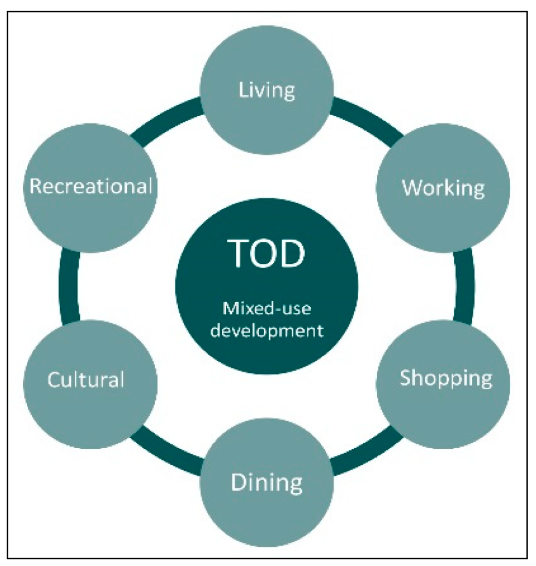
The notion of livability is defined in the literature in terms of both human- and place-oriented points of view. The former is based on the related idea of sustainability [15], while the latter refers to the degree of vitality of a given place. This can be achieved if the following measures are implemented: (a) mixed-use development leading to a pedestrian-oriented built environment; (b) attractive, safe, outdoor spaces supporting healthy activities; (c) the provision of an integrated multimodal transportation system; and, (d) attractiveness across age categories [16,17]. Figure 1 illustrates these ideas.
Sustainable development meets the needs of the present without adversely affecting the opportunities of future generations. It is widely accepted that sustainable development should not be limited to the micro scale (i.e., the level of individual buildings), but rather it must also encompass the macro scale (i.e., the level of the built environment). From this comes the concept of sustainable urbanism, which is defined as a redesign of the built environment favoring a reduced consumption of natural sources and an enhancement of the overall well-being of persons and place; this calls for a multidisciplinary approach that promotes a healthy way of life. This “new urbanism” seeks to achieve walkable neighborhoods, multimodal transportation systems, and high-performance buildings and other infrastructure. Thus, sustainable development is a comprehensive and innovative approach combining (a) new urbanism, (b) smart growth, and (c) green infrastructure [18,19].
Livability and sustainability are notions that share some overlap, in that applying key concepts of livability tend to lead to more sustainable development. For instance, the clustering of inhabitants in tall buildings permits better opportunities for mixed-use development within a given walking distance. This favors walkability and it acts to increase the use of PT systems, as well as decreasing the piping required in sewer systems and reducing the need to travel to other areas to visit facilities, such as shops, hospitals, and schools [20,21,22,23]. Easy access to such facilities leads to better livability, which results in more sustainable development.
The contrast between the two notions is as follows. While livability and sustainability both enhance the quality of life of an area’s inhabitants, sustainability is a more general concept than livability. While the notion of sustainability covers social, economic, and environmental issues, livability more specifically focuses on people’s physical quality of life.

2.2. Urban Sociology (Life between Buildings)

Urban sociology is the science concerning the relation between urban physical design and human social life; in this discipline, one studies those urban qualities that influence human social interaction in public open spaces. This is done by investigating the physical built environment that affects the level of livability and the quality of life for an area’s users [24,25]. According to Gehl, the built environment strongly affects the activities taking place in an outdoor space, which in turn determines the perceived usability of that place [26,27].
Gehl divides the activities taking place in outdoor public spaces into three categories: (1) necessary, (2) optional, and (3) social. Necessary activities are basically non-optional, and they include necessary daily activities, such as going to school or work. Optional activities only take place when outdoor conditions are appropriate or convenient; these include going out for fresh air, playing outside, or sunbathing. Social activities involve passive contact, such as “meeting and greeting” usually occurring along with one of the two other types [26].
Therefore, necessary and optional activities should be facilitated in order to foster social activities. This can be achieved by upgrading the physical built environment at locations where people of similar interests are likely to meet, such as schools, work areas, and central urban districts. Taken in this light, architects and urban planners are key societal influencers, as the design of outdoor spaces has a crucial influence on the time that people are likely to spend in the places in which these activities take place [26]. Figure 2 illustrates some of these ideas.
Thus, Gehl suggests that the design of public spaces should encourage people to gather and interact, as this leads to vibrant and livable public spaces. If planning is instead centered around the use of automobiles, the result is likely to be public spaces that are less active. The desire to avoid this problem has led to the movement toward TOD. A neighborhood following the TOD principle should be contained within an 800-m radius of a transport hub (such as a metro station), which serves as the center of development within that radius. Thus, TOD promotes the use of public transportation and, if implemented on a large (city-level) scale, it minimizes sprawling, car-dependent developments. In a TOD, outdoor public activities are supported, as mixed-use development permits users to address their daily needs within a comfortable walking distance. TOD is designed to support all modes of PT, including walking, cycling, and the use of bus and metro systems, as depicted in Figure 3. The built outdoor environment of such a neighborhood must also be well designed, incorporating attractive features, such as green areas, seating spaces, fountains, gathering nodes, parks, and cafés [6,28].
In order to achieve a successful TOD, it is therefore crucial to consider human behavior and activities, and aim to foster a sense of belonging for users. The study area that is investigated in the present research serves as an illustrative example, as TOD principles should also be considered in the areas surrounding the stations being developed as part of Doha’s new metro project.

2.3. Geographical Context (Urbanism in Qatar/TOD in Qatar)

Qatar is one of six Gulf Cooperation Council (GCC) countries located on the Arabian Peninsula. A turning point in Qatar’s economy took place in the decades following World War II, as the revenues from oil and natural gas increased dramatically. The resulting economic boom caused a rapid evolution of the country, from one that was centered on fishing and pearling to one fueled by an energy-based economy. Qatar has recently made efforts to modernize and to diversify its economy; this shift has resulted in enormous development in all sectors and at all levels [29].
As part of its efforts to raise its profile, Qatar has also hosted a number of large-scale international events, starting with the World Youth Cup in 1995, and continuing with the West Asian Games in 2005, the Asian Games in 2006, and the upcoming FIFA World Cup in 2022. These mega-projects have been accompanied by rapid and massive development [2]. As Qatar pursues such efforts to modernize and bolster its image at the global level, it has been crucial to develop a set of guidelines to govern these processes.
Qatar’s Ministry of Municipality and Environment (MME) established Qatar National Vision (QNV) 2030 and Qatar National Development Framework (QNDF) 2032 in 2011 to combat any urban design deficiencies (e.g., traffic congestion, land infiltration, lack of affordable housing, or pollution issues) that could potentially be faced by the country as a result of globalization. These plans aim to create sustainable development at the country level, such that world-class facilities are provided for Qatar’s inhabitants while sustaining the country’s resources for future generations [30]. QNDF 2032 tackles issues that are related to transportation, zoning regulations, planning codes, and urban design guidelines, aiming to confront various challenges of urban growth, such as traffic congestion, air pollution, greenhouse gas emissions, and issues that are related to food security and land value [29,30].
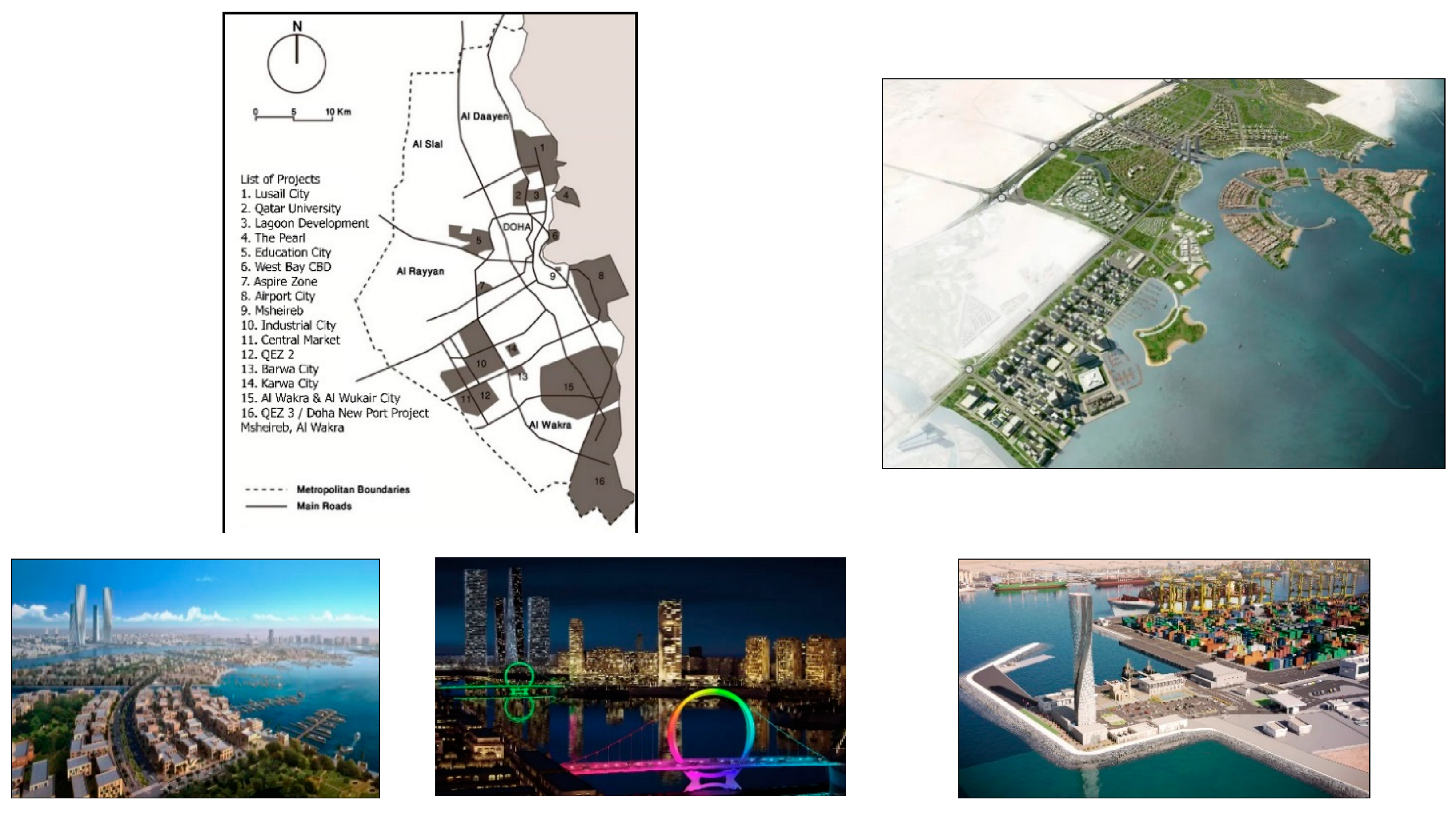
Qatar has dedicated a large amount of funding for infrastructure development projects, including a 100-billion-USD investment for enhancing the transportation system. Extensive transportation infrastructure and built environment improvements are currently under construction, particularly in Doha; such items include the new metro project, Lusail light rail, Msheireb light rail, and Bus Rapid Transit (BRT). Figure 4 shows some of these major projects. A key goal is to complete these projects in time for the 2022 World Cup. The metro is designed to connect all parts of Doha, including important points of attraction, such as major neighborhoods, stadiums, the Doha port, and Hamad International Airport. The metro will ultimately consist of four major lines covering 240 km and including 107 stations. This includes underground, above-ground and raised lines. Three lines are already in operation; the red line connects Lusail and Al Wakra, the green line connects Al Riffa with Al Mansoura, and the yellow line connects Aziziyah with Ras Bu Aboud. The blue line is expected to come into operation around 2025. The metro is one of a number of major projects being completed in preparation for the 2022 World Cup, and it is already helping to both reduce traffic congestion and create an engaging built environment in the city of Doha [2,3,4].
QNDF 2032 aims to achieve a set of long- and short-term goals by 2026, involving infrastructure, metro and long-distance rail projects, and the development of key neighborhoods. The latter includes the main urban centers (e.g., Education City, Airport City, and West Bay) as well as supporting nodes. QNDF 2032 foresees active and livable neighborhoods with mixed-use development around metro stations, in which the land use and transportation systems are integrated within a dense, compact urban form. Consequently, the metro project is an opportunity to create vibrant neighborhoods in Doha with a good quality of life.

3. Research Design

This research paper has two aims. First, it assesses the level of livability around the West Bay metro station from a TOD perspective, focusing on the area within an 800-m radius of the station. This analysis is mainly concerned with the relationships among land uses, the PT system, and the outdoor built environment. Second, it proposes a master plan that is aimed at creating a more vibrant and sustainable neighborhood following new urban design guidelines. This study site has been chosen for multiple reasons, including the fact that the West Bay metro station lies at a key location within the contemporary Central Business District (CBD) of Doha. This West Bay neighborhood is considered to be the main financial and economic hub of Qatar.
This research project was carried out in three main stages, as detailed below and summarized in Figure 5:
(1)
Theoretical background. The literature review examines the concept of TOD with emphasis on livability, sustainable urbanism, urban sociology, and urbanism in Qatar. A thorough understanding of these concepts in required in both carrying out the site analysis and crafting the design proposal.
(2)
Data collection. This research study was carried out using a combination of qualitative and quantitative methods. The qualitative methods included site visits and the collection, development, and analysis of maps and other visual materials. Data collection involved face-to-face interviews with key planners and engineers from Qatar Rail, the Ministry of Transportation and Communication (MOTC), Mowasalat, and the Ministry of Municipality and Environment (MME). These interviews were carried out to collect the data needed for understanding the current and future plans of Qatar regarding transport system development. The site visits and interviews were conducted between 25 August and 15 November 2020. The field surveys included four site visits and explored the study area’s land uses, outdoor spaces, street conditions, and transportation modes. In addition, one-on-one semi-structured interviews were carried out with design professionals from different municipal authorities and other stakeholders involved in city planning and transportation (Qatar Rail, MOTC, Mowasalat and MME) in order to better understand the current regulations and future plans.
(3)
Site analysis and design proposal. Through the site analysis, a number of positive and negative features of the current West Bay neighborhood have been identified. Being informed by this analysis, a master plan and design guidelines are proposed, which, if successfully implemented, can lead to the development of a vibrant TOD.

Case Study Settings

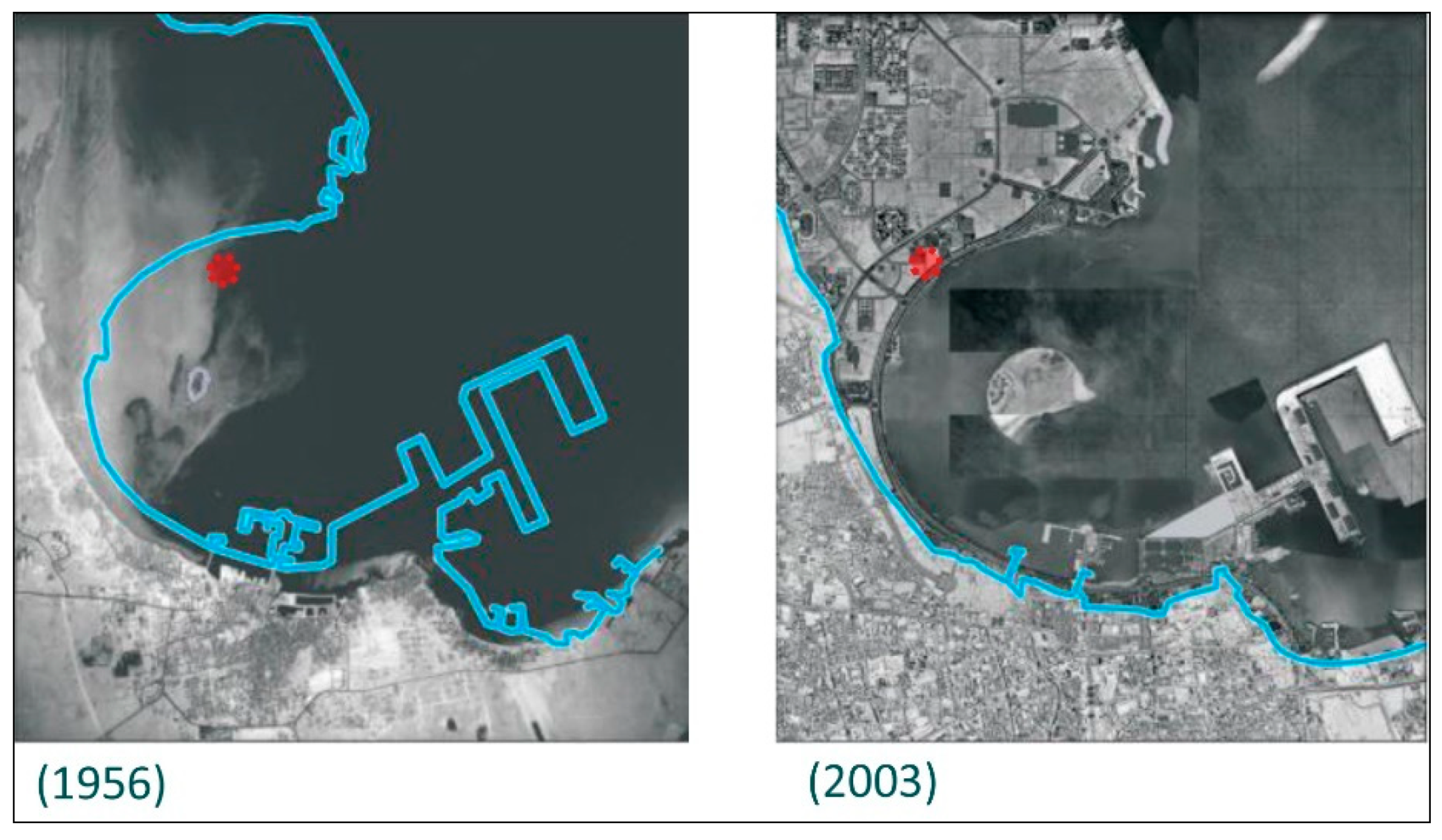
Doha initially developed as an Islamic city featuring a low-rise building morphology. In the wake of modernization, this morphology has been largely replaced with one that is characterized by high-rise towers reflecting Doha’s new image as a global city [34]. Within the West Bay neighborhood, this development has taken place in four major stages, as summarized below and illustrated in Figure 6.
(1)
During the initial phase, beginning approximately half a century ago, the area now called West Bay was developed from reclaimed land.
(2)
During the second phase, the area began to accommodate high-end villas.
(3)
The third phase saw a change in regulations permitting tall buildings to be constructed, without consideration of the resulting built environment at the street level.
(4)
For the fourth phase, it is recommended that regulations change in line with QNMP 2030, in order for the West Bay area to be reimagined as a livable neighborhood active 24 h a day [34].
The West Bay area is well known for its architectural style that incorporates a variety of glazed high-rise buildings, enhancing the skyline of Doha and boosting the city’s image as a cosmopolitan city. At present, this area suffers from traffic issues, especially during rush hours on the main roads, which include Majlis Al Taawon Street, Al Corniche Street, and Al Markhiya Street. Building regulations only define minimums, with a minimum tower height of G + 15 and a minimum setback of 12.5 m [31,34]. Public outdoor spaces, sidewalks, outdoor activities, cafés, and shaded walkways are generally absent, limited, or of poor quality. Applying TOD concepts to the West Bay metro station area would reduce the reliance on cars and increase PT ridership. A well-connected PT network, together with attractive outdoor spaces and changes in the vertical and horizontal land uses in the area, can transform it into a vibrant and livable neighborhood.
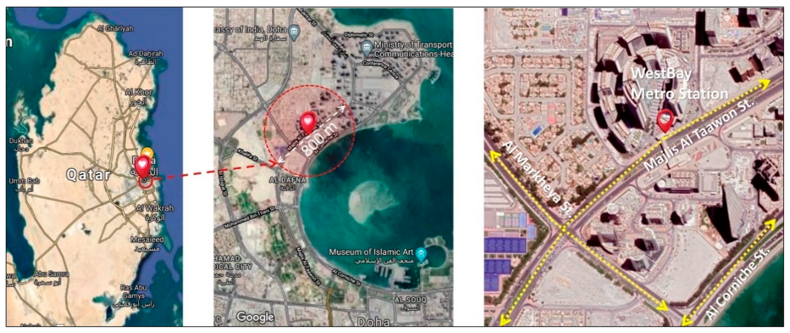
Figure 7 and Figure 8 illustrate the target area of this research paper. The West Bay metro station is located on Majlis Al Taawon Street, adjacent to Qatar Petroleum District, which is located within West Bay. The station, located on the north-south red metro line, began regular operations relatively recently. In the future, this station is expected to attract many users because of its location within Doha’s CBD, especially when other components of the city’s PT system become fully integrated with the metro.

4. Findings

The findings section is divided into two main parts, covering (1) site analysis and (2) the design proposal. The site analysis addresses the current site conditions, including land use, building prototypes, open and green spaces, street cross sections, building density, and transportation modes. The design proposal then outlines a series of recommendations, in response to the deficiencies that were identified in the previous section aimed at creating a livable, active TOD.

4.1. Site Analysis

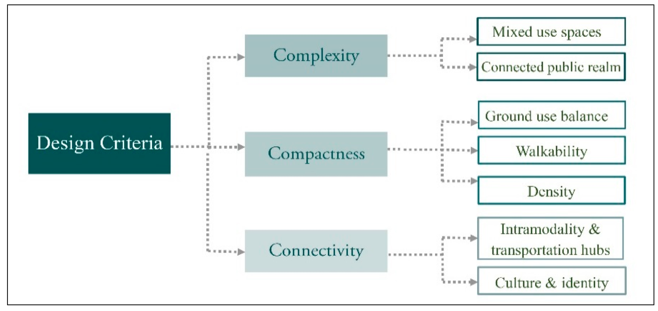
As shown in Figure 9, the site analysis section focuses on three main criteria: (1) complexity, (2) compactness, and (3) connectivity. Each criterion has sub-criteria that are used to analyze the existing site conditions and, thus, inform the subsequent design proposal.

4.2. Complexity

4.2.1. Mixed-Use Space

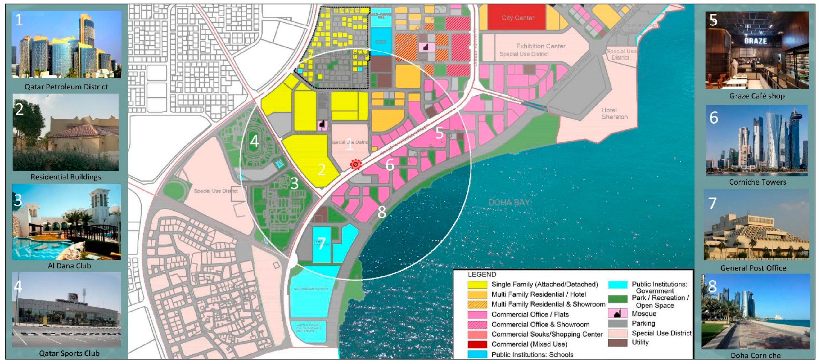
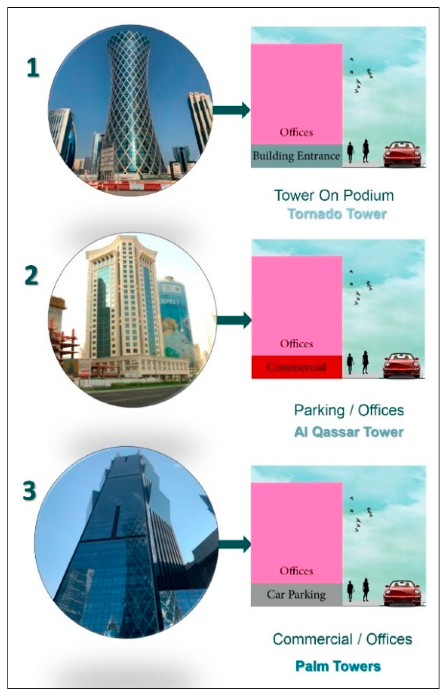
West Bay station is located in the Qatar Petroleum District, as mentioned earlier. It is surrounded by a multi-use area, including a school, a petrol station, malls, cafés, mosques, parks, and sports clubs, and it is fed in part by the Doha Corniche. High-rise towers are the dominant building style; governmental authorities and commercial offices occupy many of these, but some are residential. The land uses in West Bay, as shown in Figure 10, break down, as follows: 25% for residential, 50% occupied by commercial offices, 10% as community infrastructure and/or open space, and 15% “special uses”. Building codes do not specify the function of the ground floor, so that, for example, in the adjacent Al Dafna district, there are three different tower prototypes: (1) towers on podiums, (2) parking/office structures, and (3) commercial/office structures. Figure 11 illustrates these. In the first of these, the ground floor is typically of double height, and it is used as the building’s reception area, as is generally the case for buildings housing governmental authorities, such as the Qatar Ministry of Justice. In the second type, parking/offices, the lower floors of the building are used for car parking and the floors above house offices; this can be advantageous for building users given the general lack of car parking in many areas. Al Qassar Tower, as shown in Figure 11, is a typical example of this category. In the third type, commercial/offices, the lower floor(s) of the building are used as cafés or for other commercial use, with the floors above being used as offices or for residential use; examples of these include Al Salam Towers and Palm Towers.
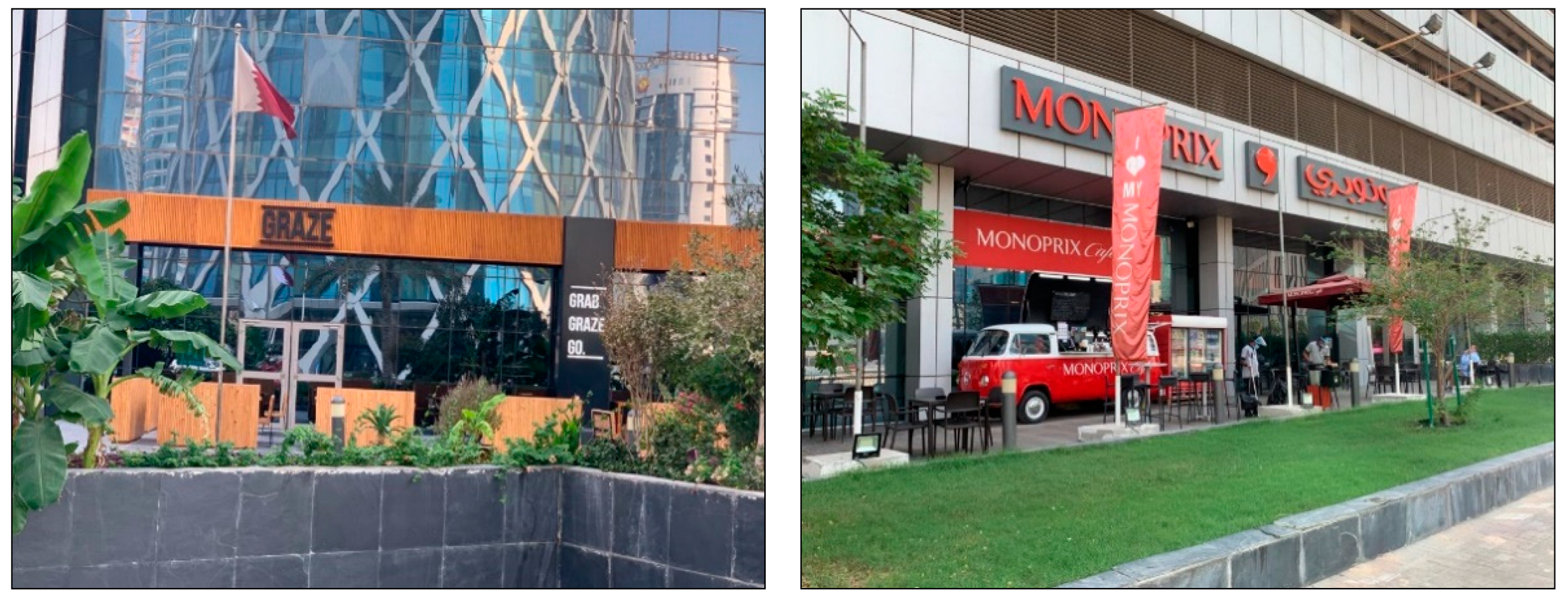
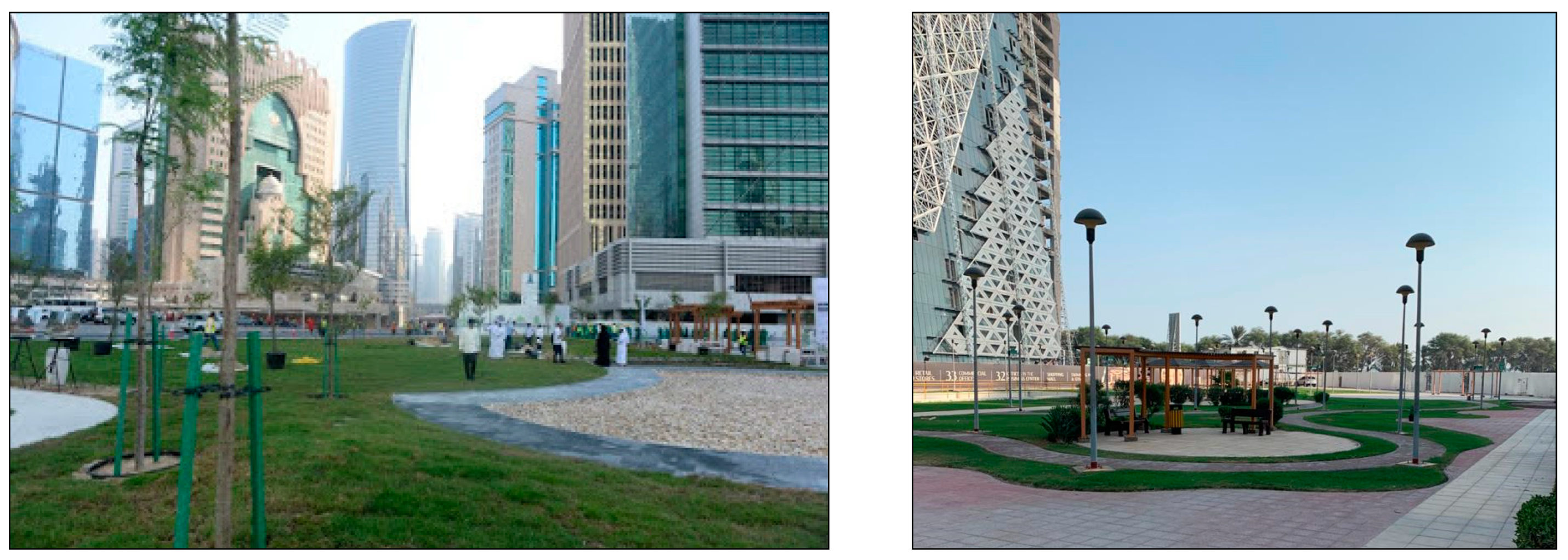
Although Al Dafna is a mixed-use area, it is not as vibrant as it could be, due to flaws in the built environment. There is a general lack of public open spaces and, ideally, each building should have its own public facilities. This is the case, for example, with Palm Towers; this building features a variety of commercial enterprises at its ground level and hosts attractive outdoor facilities, as shown in Figure 12. Other than rare exceptions like this, the built environment in this area is not fully consistent with the concept of mixed-use development, in which many facilities should be available within walking distance, and in which the street network should aid pedestrians by providing safe and well-connected pathways with shading elements. In addition to this, there are some outdoor green spaces in the area that are neglected and, thus, do not attract many users; some of these are shown in Figure 13.

4.2.2. Connected Open Spaces

In addition to the general lack of open spaces in the Al Dafna district, even those that do exist there are not well connected. There are several locations in the area that are potentially attractive, including the waterside Doha Corniche, Al Dana Club, a green area next to Qatar Club, Sheraton Park, and Al Abraj Park, all of which lie in relatively close proximity, as illustrated in Figure 14. However, these open spaces do not attract as many users as they could, because the built environment in the area is not well designed. The street network is not pedestrian-friendly, and the area as a whole is not well connected, lacking sufficient street crossings, shading elements, and street furniture. The street cross section should be redesigned to better support pedestrian traffic and the increased use of outdoor spaces. Although the street medians are generally aesthetically pleasing, they are often not practical; they should be redesigned so that they can host recreational activities, kiosks, seating areas, outdoor galleries, trees, and street furniture. A much more attractive outdoor environment can be provided through better integration.

5. Compactness

5.1. Ground Use Balance

QNV 2030 specifies four pillars of development—human, social, economic, and environmental—that support an attractive and livable country. As Qatar moves forward, guidelines concerning open space, recreation, and sporting facilities have been developed, aiming for world-class open spaces and recreational areas within a greener built environment (MME, 2020). At the study site, open spaces and greenery currently constitute 39% of the total site area. These green spaces include areas around sport clubs, along the Doha Corniche, small parks among the towers, and street medians; these green areas, as presently implemented, are more decorative than functional. The collective area of green spaces and other locations that are suitable for outdoor activities should be increased in order to create a more outdoor-oriented environment. According to the United States Environmental Protection Agency [36], green and open spaces can be developed in any vacant land open to the public, including, but not limited to:
1.
green areas (parks, gardens, and any other land covered by grass, shrubs and/or trees),
2.
public plazas,
3.
public seating areas,
4.
school yards,
5.
playgrounds, and
6.
vacant land.
There are currently no national standards concerning the distribution of parks and open spaces in Qatar; planners are using outdated norms introduced in 1987 and 1996 [36]. However, we can compare the study site with three cities which according to WorldAtlas are top-ranked in terms of providing public green space, namely Moscow, at 54%; Singapore, at 47%; and, Sydney, at 46%. At 39%, the study site’s value is probably acceptable, but it can be improved to the range of 46% to 54% [37,38] argues that, in designing and implementing green spaces, it is crucial to consider proximity and connectivity, such that parks are conceived as a center of neighborhood development and reachable within a 5-min. walk.
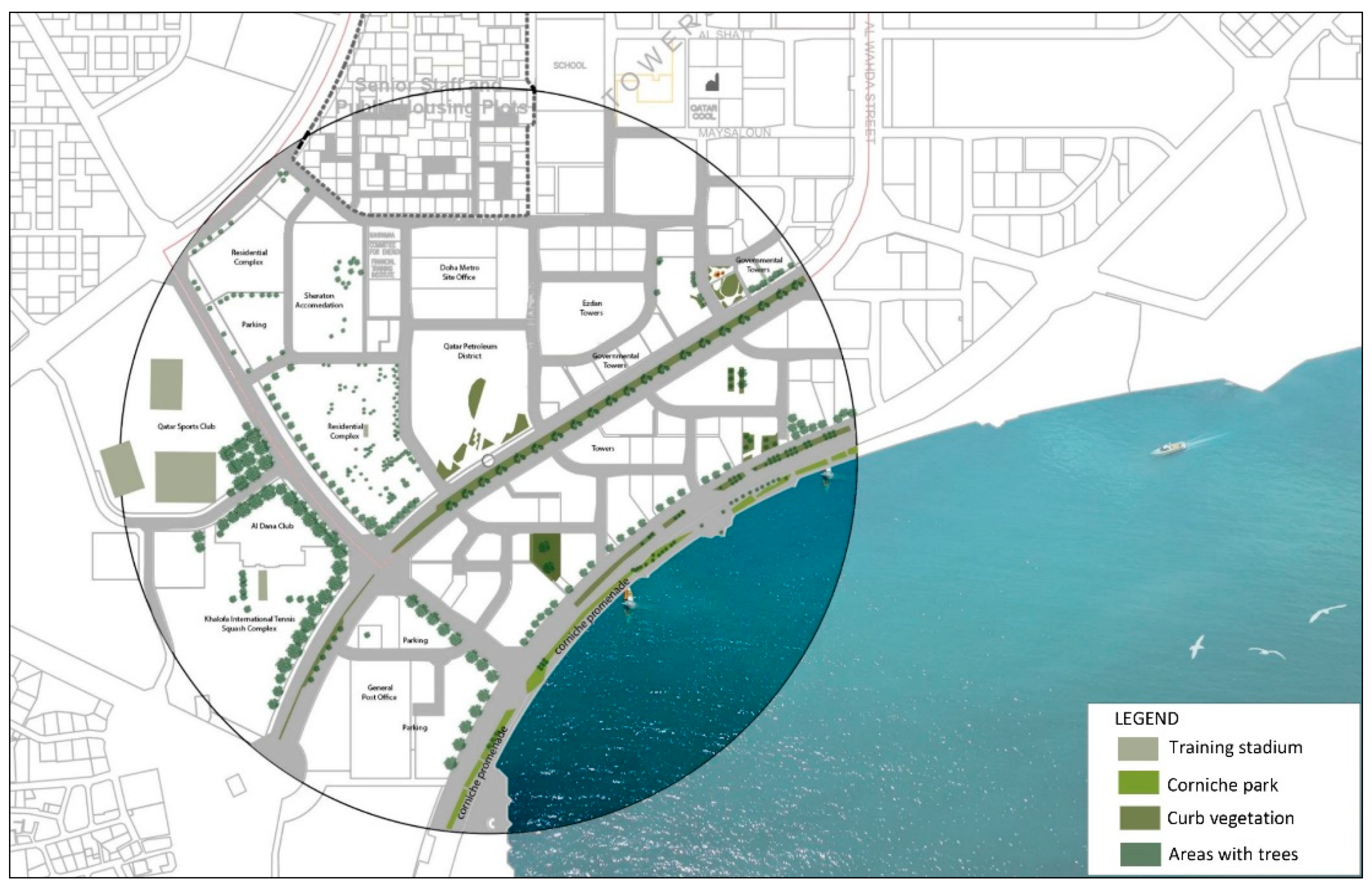
Areas supporting greenery and outdoor activities should be enhanced in a number of ways. At a given location, there should be a central activities area that is connected with smaller such areas, and greenery should not be merely decorative, but rather it should include shading elements and fruit trees. Figure 15 depicts the current status of the study.
The Qatar National Development Framework also provides a number of criteria governing open spaces. First, they should be sustainable, favoring the conservation of resources for the benefit of future users. They should promote a good quality of life for all, through the creation of user-friendly environments that serve all age groups. They should be developed in consideration of the local identity; the built environment of outdoor spaces should be reflective of Qatari culture. They should be consistent with environmental values, and should promote the connectivity of people and place, being located within well-connected transport networks and, thus, easily reached by users. Finally, they should support economic growth, as the development of such areas can bolster economic development, for example, by creating attractive neighborhoods with concomitant increase in real estate values. Figure 16 illustrates these ideas.

5.2. Walkability

Walking is a sustainable and healthy mode of transportation: sustainable because it does not cause air pollution and healthy because it is good for people’s psychological and physical well-being. Proximity, connectivity, and sidewalk width are the three fundamental factors that affect an area’s walkability. Connectivity refers to the availability of street networks as one attempts to move safely from the origin to the destination, while proximity simply means the distance between those two points [39].
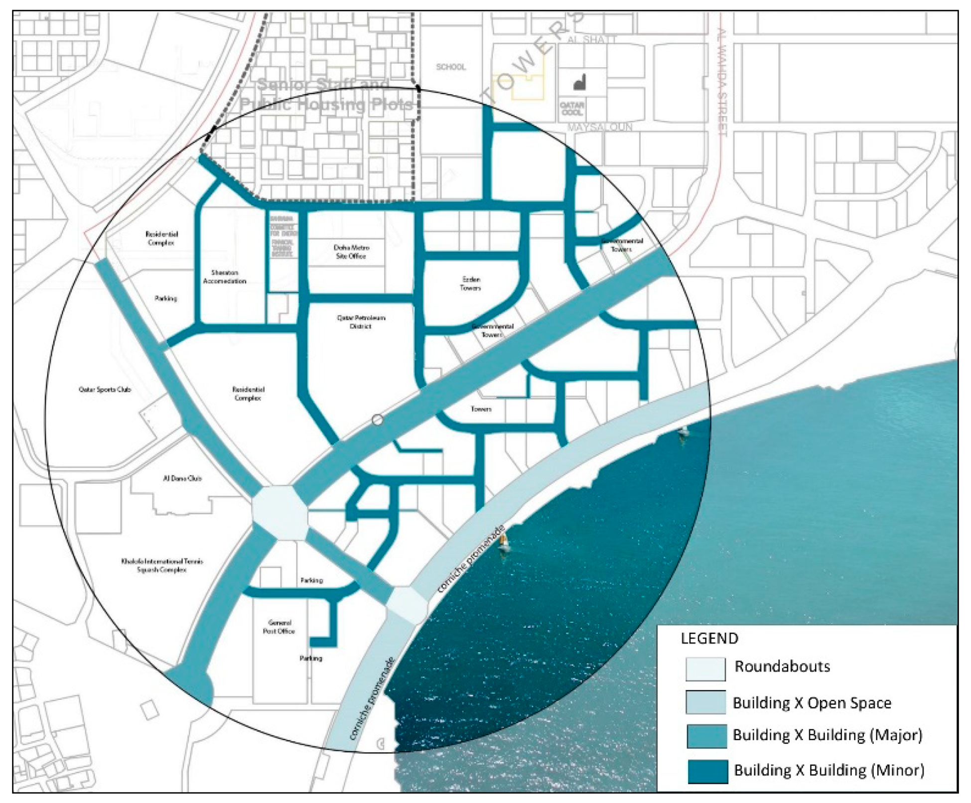
There are three street prototypes in the studied site: (1) building × open space, (2) building × building on a major street, and (3) building × building on a minor street. Figure 17 and Figure 18 illustrate these. Each type differs in the width of its sidewalks and in the amount of space that is dedicated to cars. Throughout the study site, sidewalk width in all three street categories is sufficient, in principle, for walking; however, the reality is that walking is impractical or impossible for multiple reasons. For example:
(1)
infrastructure work for the metro development project often blocks sidewalk access, as if there were no sidewalk at all in certain spots;
(2)
street networks are not well connected for pedestrians and, in particular, street crossings, found at 800- to 1500-m intervals, are inadequate; and,
(3)
there is a lack of shaded walkways, which makes travel on foot arduous at best on summer days.
This neighborhood is a typical car-dependent area, in that the built environment does not support pedestrian use. The streets have as many as three car lanes in each direction, which, together with a lack of sufficient street crossings, makes travel on foot quite hazardous. Along with the overall lack of shading elements, connectivity, and proximity, the result is a neighborhood that ignores the human experience of place. To remedy this, more street crossings should be created, and consideration should be given to mitigating the effects of Doha’s hot and arid climate. Shading and other design elements should be provided, while taking street orientations, building heights, sea breezes, and the prevailing northerly wind into account. Earlier research in regions with a climate similar to that of the study site—including Damascus, Algeria, and previous work in Qatar itself—supports these contentions [3,40]. The result can be a successful, walkable urban space within an attractive, livable neighborhood.

5.3. Density

Figure 19 shows the density and building conditions that prevail in the study area. Most of its buildings are in good condition because the area is newly developed. A mix of high-density and low-density development characterizes the region within an 800-m radius from the West Bay metro station. The higher-density region is mostly concentrated in the southern part of the studied area, where there are many office buildings and large residential towers, while the lower-density region contains a large number of smaller single-family homes. As noted earlier, building regulations call for towers in this area to have a minimum G + 15 height. Based on TOD principles, it is important to have a high building density around the station. However, these buildings should occupy a mixed-use environment that serves the residential, commercial, and daily needs within a comfortable walking distance.

6. Connectivity

Intramodality and Transport Hubs

QNV 2030 foresees the development of a sustainable transportation system, including the metro project and the massive development of the bus system. This should decrease residents’ reliance on automobile use, which is still the dominant transport mode in the country. There are three road types in the studied area, which vary from arterial roads with three lanes in each direction, to collector roads with two lanes in each direction, to local roads with one lane each way.
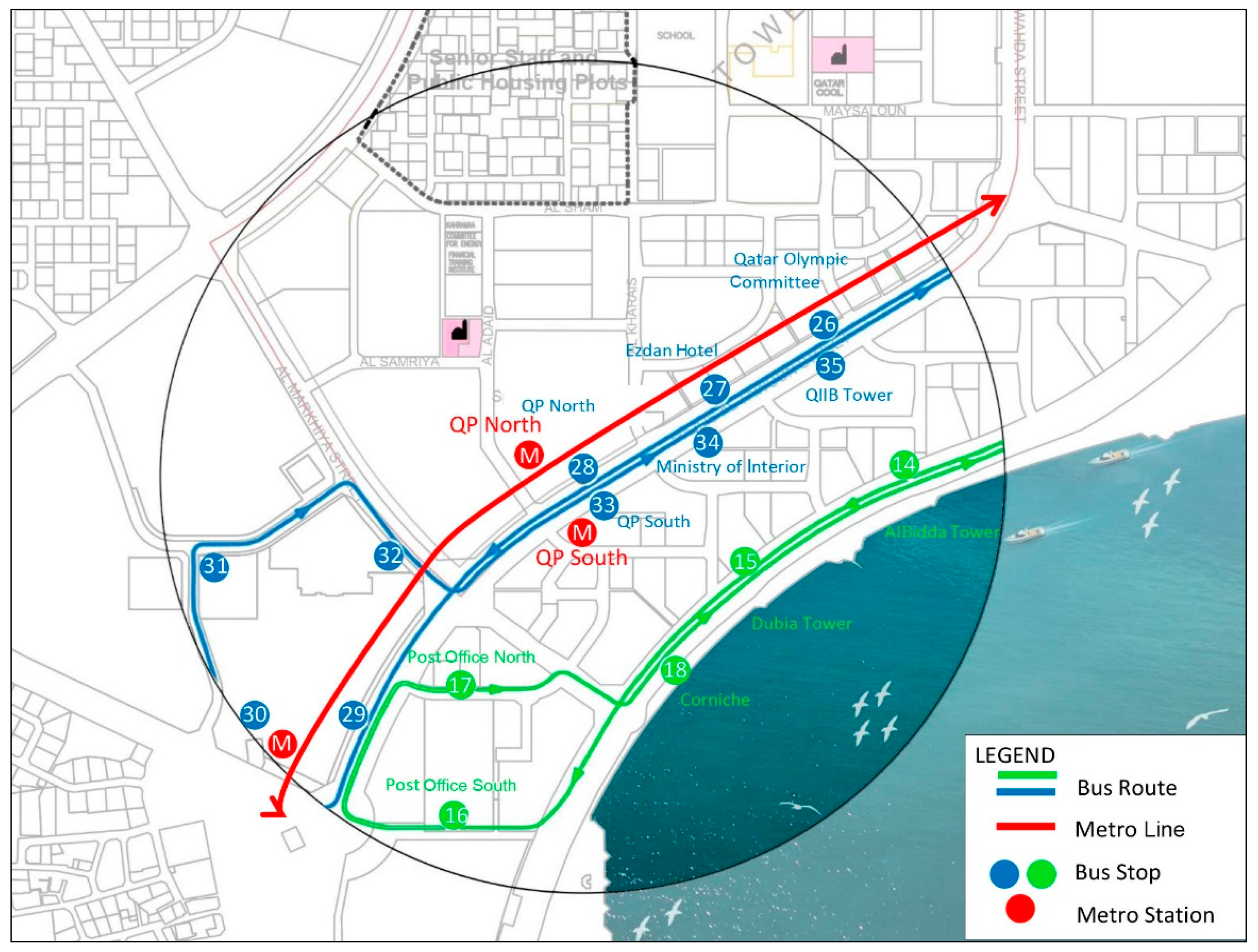
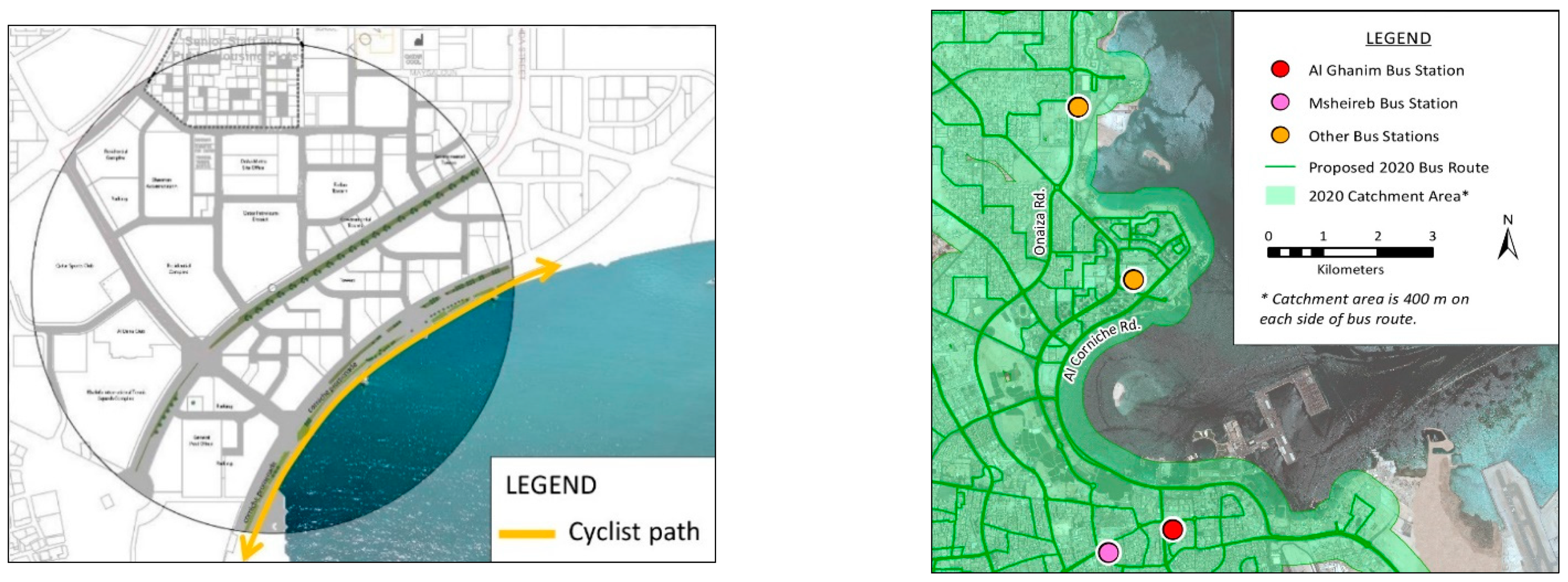
As of the time of writing this research paper, the metro system network is not fully operational. However, a good bus network serves the studied area, with bus stops at 400-m intervals. Walking for 400 m takes five minutes on average, which means that this is a successful catchment area, as shown in Figure 20 and Figure 21. Buses run daily from 6 am to 12 midnight at 15-min. intervals, which should be reduced to five minutes in the future. Each metro station has a bus stop and a pick-up and drop-off area for taxis. When properly implemented, these are features of a successful multimodal transport system.
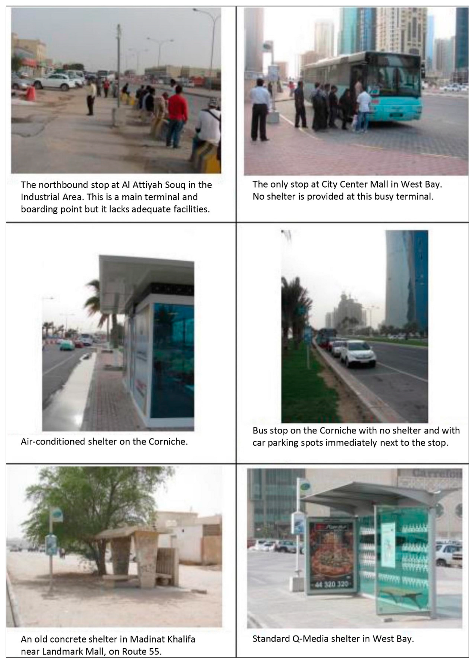
The major deficiency in the West Bay district in achieving a successful integrated public transport system is its very poor pedestrian and cyclist networks. The built environment is not designed to respect pedestrians or give them right of way, which makes walking inconvenient, unpleasant and—in some places—simply hazardous. These problems include disconnected paths, unshaded walkways, and lack of street crossings, as shown in Figure 22. The distance between pedestrian crossings here is typically 800 to 1500 m, meaning a walk of about 10 to 20 min. The unshaded walkways make walking during the city’s many hot days unpleasant or even dangerous. The lack of street crossings and street furniture also makes the walking experience exhausting. The situation for cyclists is perhaps even worse, as cycling paths are effectively non-existent, except along the Doha Corniche, as shown in Figure 21. Subsequently, creating a successful TOD requires a redesign of the street network in the area, so that it supports both pedestrians and cyclists and is properly integrated with the metro and bus systems. A few positive steps have recently been taken along with the opening of the metro system. Some air-conditioned bus shelters have been introduced, and a number of other improvements in bus shelter design have been made in various parts of the country, as shown in Figure 23. These developments are likely to encourage more people to use PT, as they make the travel experience more pleasant.

7. Design Proposal (Master Plan)

The design proposal for the West Bay metro area is presented in this section. This plan is informed by the findings that are outlined in the foregoing discussion as well as general TOD principles, and it is focused on addressing the following needs: redesign of existing streets, introduction of a new car parking policy, support of mixed-use development, and the provision of more outdoor open spaces and greenery.

8. Connectivity

8.1. Multi-Modal Transportation/Green Corridors

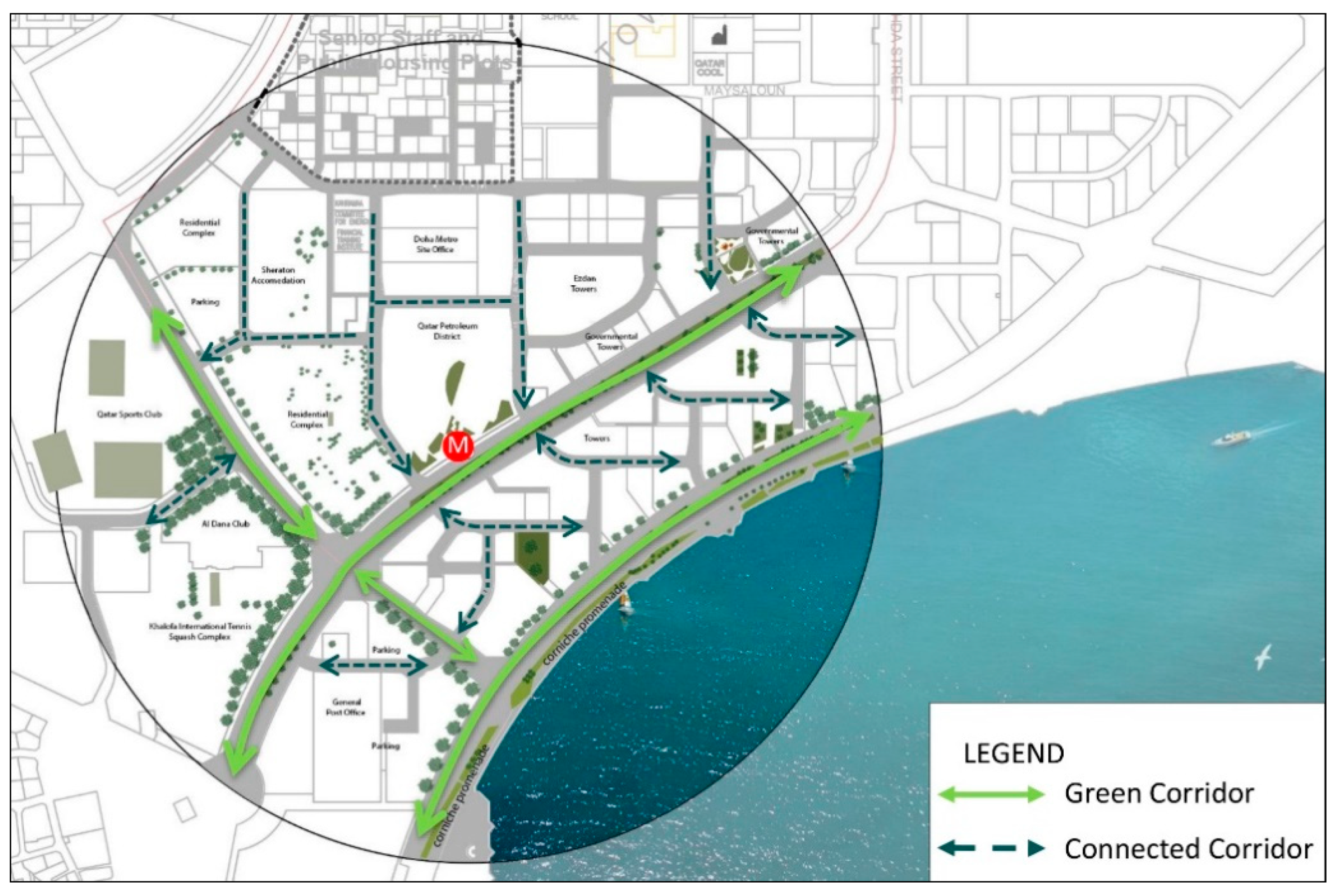
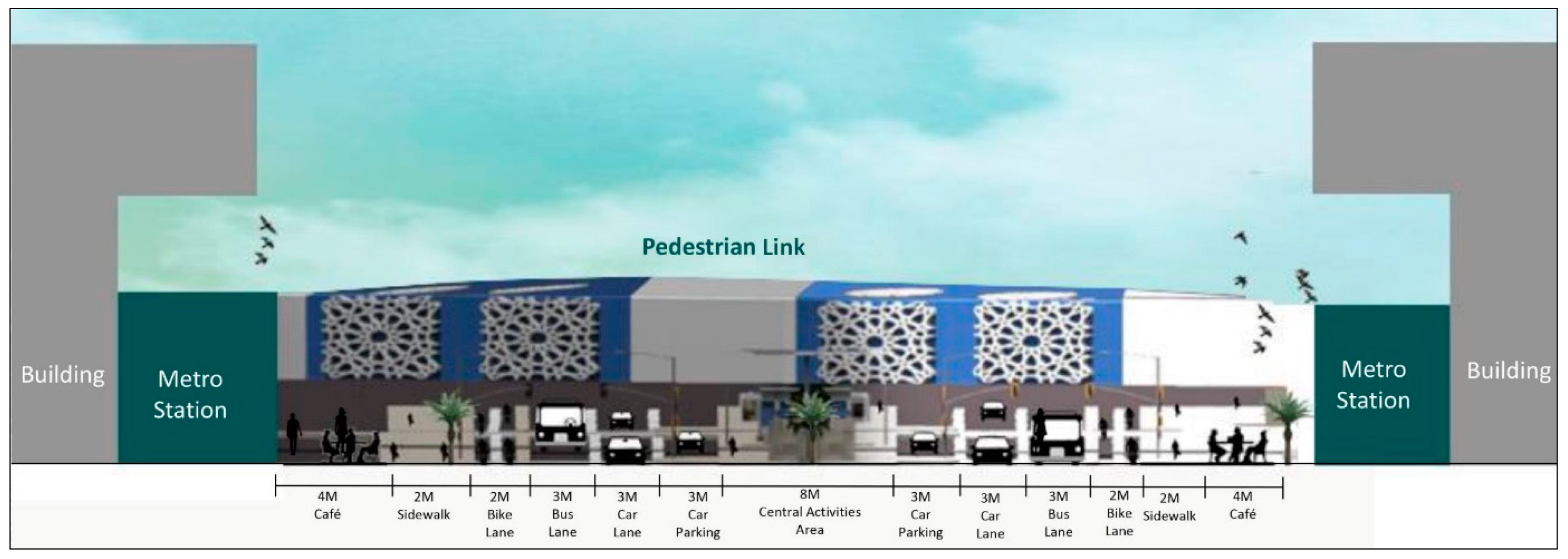
Despite the issues that were noted earlier, the amount of green space in the study area is basically adequate and the new metro project is likely to lead to increased PT use. However, creating a more livable and vibrant neighborhood requires better integration between outdoor spaces and PT access points. A good way to address this issue is through the creation of green corridors, as shown in Figure 24. The main streets should be transformed into green corridors supporting outdoor activities and multimodal transportation, with the inner streets acting as connecting corridors. In addition, re-thinking the cross section of existing streets in the area would help to create active and well-connected outdoor spaces. Furthermore, the area should see more mixed-use development, as this will better support the area’s transformation into a vibrant neighborhood. The street cross section that is depicted in Figure 25 illustrates how the design proposal supports TOD principles by minimizing car lanes and car parking while providing pedestrian paths and bicycle and bus lanes.
The site analysis reveals that the present West Bay area is a typical car-dependent neighborhood. The bus system is almost exclusively used by low-income workers, and there are very few pedestrians and cyclists. One TOD principle is that car use should generally be minimized; therefore, it is proposed that the streets in the study area be limited to having a single car lane in each direction, with the remaining space on the road being devoted to pedestrians, cyclists, and a single bus lane. Furthermore, greenery should be provided, and initiatives should be implemented encouraging the creation of small businesses, such as cafés, adding to the character of the streets and helping to create a more livable mixed-use environment. The presence of well-connected pedestrian and cyclist networks is also desirable, as this will mean the increased use of the metro and other PT. Bus stops should be serviced more often; the plan to reduce the current 15-min. waiting intervals to five minutes will be a welcome improvement, as this will also support increased PT ridership.

8.2. Car Parking Policy

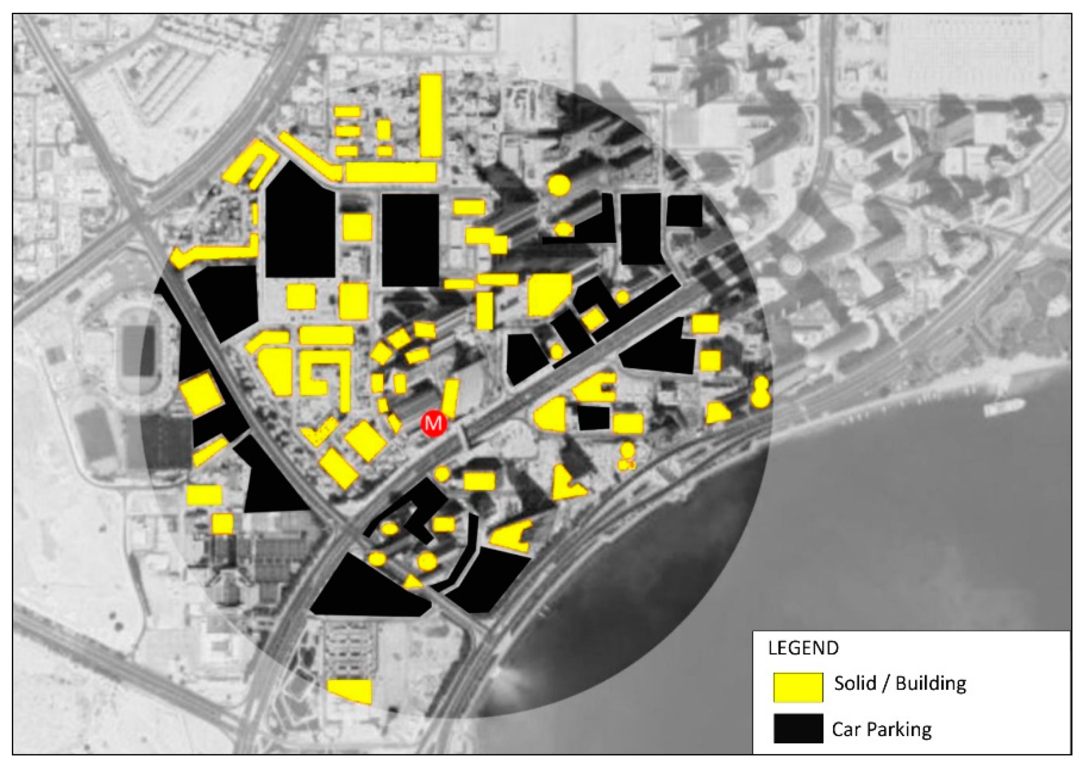
Based on MME regulations, the minimum setback around towers is 12.5 m. At present, there are adequate setbacks around the towers within the study site. Unfortunately, these areas are not generally utilized as outdoor green spaces that are suitable for recreation and supporting an active human presence; instead, they most often serve as car parking areas, adding to a sense of dullness in the neighborhood. Figure 26 shows the current distribution of the neighborhood’s building and car parking areas. Based on TOD principles, the number of parking areas should be reduced, so that they constitute a total of under 12% of the entire site area. If the use of private cars is reduced as PT ridership increases, then there will be less of a need for parking areas, so that these spaces can be enjoyed as outdoor green gathering spots.

9. Complexity

9.1. Mixed-Use Spaces

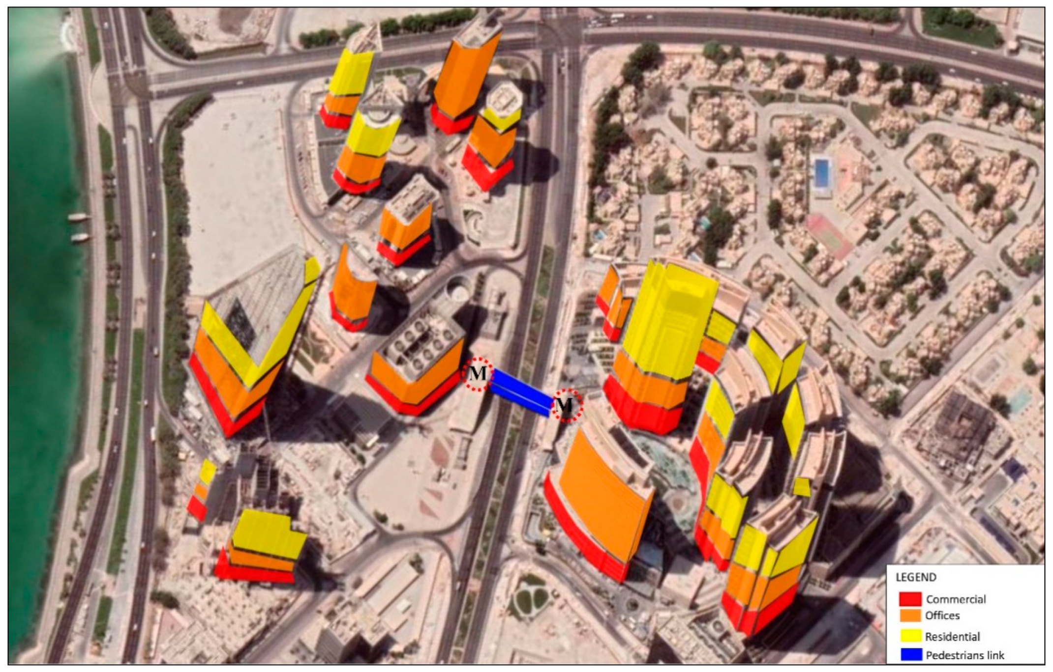
Achieving mixed-use development at the study site will require a high degree of density around the West Bay metro station. However, a mixed-use TOD should enable the area’s residents to perform their daily needs within a comfortable walking distance; this is not presently the case in the study area. Therefore, it is proposed that the land/building use in the area be modified, as shown in Figure 27 and Figure 28, such that more buildings’ lower floors support commercial uses, middle floors contain office space, and upper floors serve residential needs. In certain cases, it may be desirable to avoid having offices and residential space within a single building, as may be the case if a building houses government authorities. In such cases, buildings will consist of commercial space and offices only.
The building density is high in the studied area, and the West Bay neighborhood tends to be very active during daytime hours. However, at night, the area can seem to be almost deserted, because the dominant land use at present is office buildings. This is why a crucial component of the proposed design is a change in land use to more of a mixed-use development. This would decrease car dependency and increase the use of PT facilities.

9.2. Connected Open Space

The new proposal suggests connecting the study area’s outdoor open spaces by providing better access to multiple transportation modes. This is done, for example, by introducing special lanes for buses, pedestrians, and cyclists. A better-connected street network facilitates outdoor activities, which are also more likely to take place in areas where street-adjacent areas and buildings’ lower floors host food kiosks, seating, shaded spaces, water elements, art galleries, and plazas, which makes the area more vibrant and attractive.
The following changes should also be implemented. First, the southeastern part of the site should be redesigned, so that its outdoor spaces take better advantage of the local sea breeze, improving users’ experience by creating a more favorable outdoor microclimate. Second, the northeastern part of the site should be redesigned to allow better accessibility for the area’s users. Third, the central part of the site should be reimagined as an attractive focal area, providing easy connectivity among all parts of the site. This trend of converting largely abandoned outdoor spaces into more active ones has recently been observed in a number of locations in Qatar, including the Katara and Lusail night markets, for example, and the success of this approach is clearly seen in those places, which are now often packed with users, especially in the evenings.

10. Compactness

10.1. Ground Use Balance

The design proposal suggests that the site’s green areas and other outdoor spaces be expanded and improved, in large part by taking better advantage of existing unconnected green spaces. This can be done by introducing green corridors, dedicating large parts of street-adjacent areas to green areas and similar spaces that are conducive to outdoor activity. It is crucial that these outdoor spaces be properly connected with continuous pedestrian and cyclist paths, which are fully integrated with high-frequency bus and metro services.

10.2. Walkability

Walkability plays a fundamental role in a successful TOD, but, unfortunately, this is also a major area of weakness at the study site. The design proposal solves this problem in part by dedicating space to pedestrians on each side of the street. However, creating a genuinely walkable area means more than simply providing pathways from one location to another; it also requires the provision of shaded walkways, trees, seating areas, and street furniture, as well as more numerous and convenient street crossings.

10.3. Building Components/Use of Energy Systems

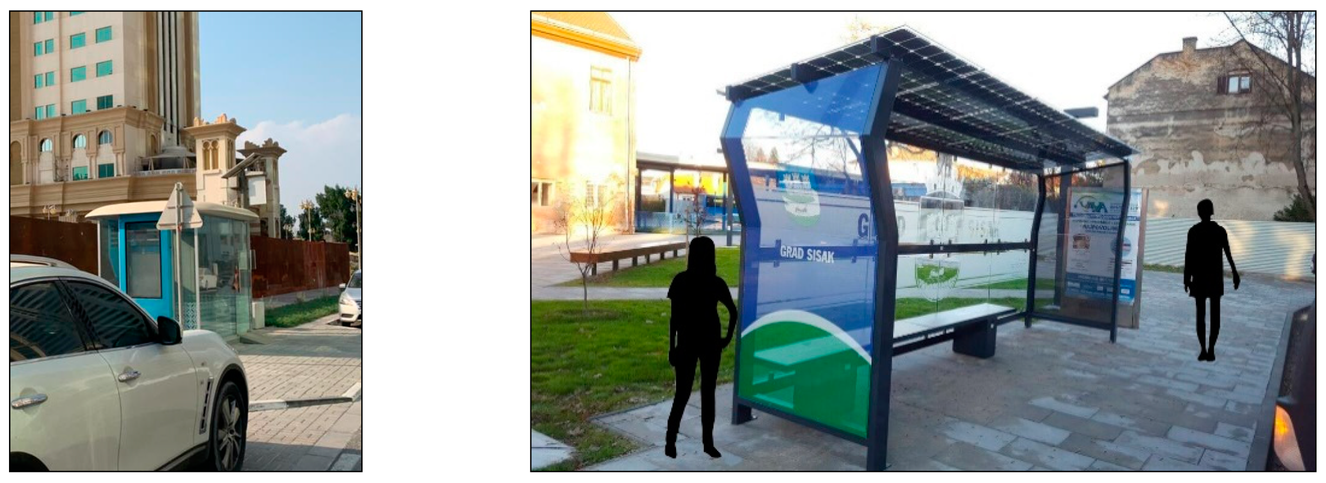
In the studied area, there is little or no evidence of any renewable energy elements at the building level, with the exception of photovoltaic (PV, i.e., solar) panels on some bus stops, as shown in Figure 29. However, these panels are very small and, thus, the energy captured is quite minimal. Therefore, it is proposed to widen the use of solar panels, mounting them, wherever feasible, onto bus stop roofs, the tops of buildings, and on shading elements that will be added to the site’s walkways.

10.4. Culture and Identity

The West Bay area has every appearance of a typical modern central business district, with tall gleaming towers that are indicative of Doha’s status as an international city. However, the area’s architectural style does not reflect Qatari identity in any significant way, with a few exceptions, such as Ezdan Tower, which is pictured in Figure 30. It will be important to introduce Qatari design features into the built environment to address this lack of a sense of identity. In the design proposal, this is done through the use of Islamic patterns in various places throughout the study site, such as on pedestrian links and street furniture, including fountains, vegetation boxes, seating areas, lighting features, and shading elements. Figure 30 also illustrates these ideas.
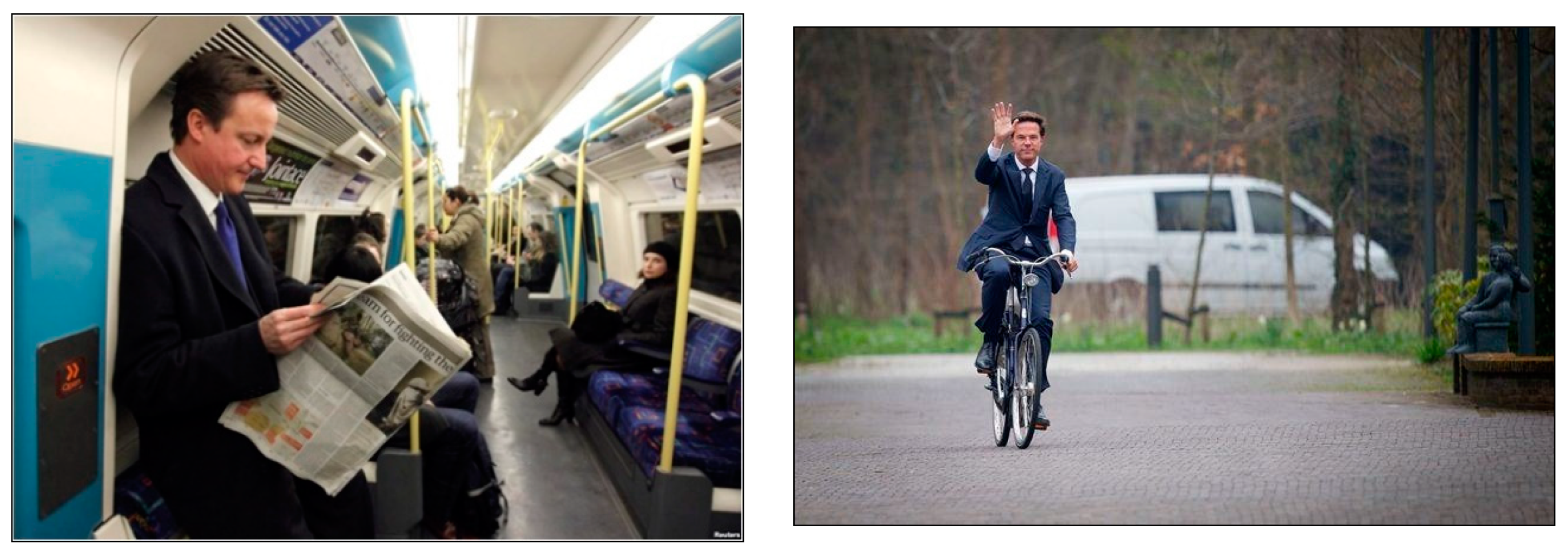
Cycling is not favored by Qatari locals for multiple reasons, many of them cultural. Locals generally believe that the hot arid climate is not suitable for cycling; the local attire, which typically includes long flowing robes for both sexes, may make cycling appear awkward; additionally, there appear to be built-in cultural beliefs against the idea of using a bicycle publicly. This is in spite of the fact that some locals use bicycles while traveling abroad. More generally, the use of PT in Qatar is often associated with low-income socio-economic groups. These attitudes can probably be changed if role models from within Qatari society are seen using these modes of transportation. The former Prime Minister of the United Kingdom, David Cameron, used the London metro to reach his office, and the Prime Minister of the Netherlands, Mark Rutte, mostly travels by bicycle, as shown in Figure 31. Similar role models could help to solve issues associated with social class and PT use in Qatar. In addition, in the interest of sustainability, other sustainable forms of personal transportation should be permitted in bike lanes; these include scooters, skateboards, and rollerblades.

11. Discussion and Conclusions

Ed McMahon, senior fellow at the Urban Land Institute in Washington D.C., has stated that “if you design a city around cars, you’re going to get more cars. If you design a city around people, you’re going to get more people and places and better real estate value” [45]. In large part, this is what has happened in Qatar, due to its rapid economic boom. As the capital city Doha has grown, its road networks have been significantly expanded, but with relatively little consideration of the modes of transport other than private cars.
In more recent times, local urban planners and designers, architects, and transportation engineers have shown an increasing awareness of this problem, and multiple development projects are now ongoing in an effort to improve the current circumstances. These improvements include the development of long-distance rail, a comprehensive bus system, the Doha metro, pedestrian sidewalks, and bike lanes. The problems that are created by dependence on private motorized vehicles include traffic congestion, air pollution, and adverse health effects, thus having a massive negative influence on a city’s perceived livability and residents’ quality of life.
In order to address these issues, a genuine shift in the prevailing design mentality is needed, and new urban planning theories must be put into practice. In the present study, the area around Doha’s West Bay metro station was investigated to determine its the current conditions. Analysis of the built environment at the site was carried out, and a design proposal was crafted, following the core principles of Transit-Oriented Development, livability and urban sociology. The proposal includes several changes that should be made in the study area.
First, the area should be transformed from one dependent on the use of cars into one offering multimodal transportation options that are integrated and well connected. A variety of sustainable modes of transport should be available, including easily accessible metro and bus services, and pedestrian walkways and bike lanes should be provided. The prevailing street cross section should be reworked, incorporating green urban corridors that cater to different modes of transportation. Second, better integration between public open spaces and the transportation network should be provided, leading to more attractive and active open spaces. The third recommendation pertains to the numerous empty plots that are adjacent to many of the area’s buildings. Most are currently used as car parking areas, which results in outdoor open spaces that are dull and essentially void of life. These car parking areas should be reduced in number and/or extent, so that they constitute no more than 12% of the total site area, and they should be replaced with greenery and recreational areas.
A fourth recommendation relates to vertical and horizontal mixed-use development, addressing the fact that, at present, the study site in West Bay is mostly used by people working at their daytime jobs. The result is that the area is very active during the day, but it is basically a “ghost neighborhood” at night. This can be remedied if most towers support multiple uses. For example, ground floors should mostly be devoted to commercial uses, with car parking also being located at lower levels. Higher levels can then host offices and/or residential units. In this way, the area’s residents can take care of their daily needs within a comfortable walking distance, which is necessary in creating a successful, livable mixed-use development.
Although the study site offers some amount of outdoor open space with onsite greenery, these places are generally lacking in multiple ways, such as in the activities that they can support and in their (lack of) connectivity with the surrounding areas. The study area will be much more attractive and livable if food kiosks, cafés, seating areas, shading devices, water elements, improved greenery and landscaping, recreational activities, art galleries, and plazas are present. A lack of walkability is also a major defect in the area; this proposal recommends that walkability be improved through the use of green corridors, with careful consideration being given to the provision of shaded walkways, trees, seating areas, street furniture, and additional street crossings.
In addition, the study site should better reflect the local culture and identity. The present West Bay neighborhood has impressive modern features, such as tall glass towers, but the overall effect is indicative of a loss of cultural memory and identity. Therefore, this proposal recommends the introduction of design elements that are inspired by Qatari culture. These design features are not limited to architectural structures, such as entire buildings, but focus more on the built environment at the human scale. Design elements consistent with the local culture should be incorporated into items such as fountains, vegetation boxes, seating areas, lighting features, and shading elements, as this will boost the area’s sense of place and identity. Implementing these design principles and making the other changes that are enumerated in this discussion will enable the study site’s transformation into a vibrant, active, and livable neighborhood.
Finally, one must remember that large-scale changes in an existing city, such as changes to its public transportation system, most likely cannot be realized in a perfected form from the early stages of design or implementation. Such issues, which involve decisions by stakeholders, including commercial interests and municipal and national authorities, fall outside the scope of this research project. This can be considered to be a limitation of the present study, which might be addressed in a further investigation that is more focused on such decision-making processes.
The authors are also aware that, while design proposals are important, it is crucial to ensure that such plans can be integrated into the decision-making process of a given area’s stakeholders. Typically, this is a process of trial and error that unfolds based on human interaction and observation as a given area develops. For example, the metro project is still very new in Qatar, and most of its stations are not yet in full operation. In spite of—or rather because of—these limitations, we feel that research of the present kind is crucial in proposing urban design solutions and recommendations, which, if implemented properly, can enhance the built environment and create a vigorous city district in harmony with TOD principles.

12. Contribution to Knowledge

This research project opens doors for other study opportunities. Future research should be aimed at developing analogous master plans for multiple stations along the same metro line, as a part of an integrated design proposal following a holistic approach that is in harmony with TOD principles. In addition, the study site at West Bay can be analyzed from perspectives other than that considered in the current project. For example, Qatar’s hot arid climate plays an important role in local users’ attitudes toward the use of public transportation. It would be instructive to explore how thermal comfort outdoors affects the level of success of PT facilities in Doha, such as the West Bay metro station.
Improvements in the integration between land use and PT should be a major component of urban planning in Qatar in the future. It is also crucial to recognize the role of the local culture and identity in establishing a sense of place and determining how local users perceive the role of public transportation. If these issues are carefully considered and addressed, the result can be more livable, active, and vibrant TOD development throughout Doha and Qatar, meeting the goals of QNV 2030.

Author Contributions

The authors contributed to this research study as follows: Conceptualization, D.A., R.F. and M.G.; methodology, D.A., R.F. and M.G.; software, D.A.; validation, D.A., R.F., M.G. and R.A.-M.; formal analysis, D.A., R.F., M.G. and R.A.-M.; investigation, D.A., R.F., M.G. and R.A.-M.; resources, R.F., M.G. and R.A.-M.; data curation, D.A.; writing—original draft, D.A. and R.F.; preparation, D.A., R.F., M.G. and R.A.-M.; writing—review and editing, R.F. and M.G.; visualization, D.A.; supervision, R.F. and R.A.-M.; project administration, R.F. and R.A.-M.; funding acquisition, R.F. and R.A.-M. All authors have read and agreed to the published version of the manuscript.

Funding

This research study was developed under the grant schemes awarded by Qatar University: Grant ID: QUCP-CENG-2021-2 [National Capacity Building Program-NCB-S1], titled: Re-thinking a Framework for the Urban Regeneration and Preservation of the Transit Villages of Old Salata, QNM, Msheireb and Souq Waqif, along the Cultural-Heritage Doha-Metro Corridor; and Grant ID: QUST-1-CENG-2021-16, titled: A Holistic Strategy for the Urban Regeneration of the Souq Waqif Neighbourhood. English editing, proof-reading, and article processing charge (APC) were supported by Qatar University, Grant ID: QUST-1-CENG-2021-16.

Institutional Review Board Statement

Not applicable.

Informed Consent Statement

Not applicable.

Data Availability Statement

All data, models, and code generated or used during the study appear in the submitted article.

Acknowledgments

The authors would like to acknowledge the support of Qatar University in providing a work environment which facilitates and motivates scientific research. This research study was developed as a part of the core course “Participatory Design and Planning” in Fall 2020, part of the PhD program in Architecture at Qatar University. The authors would like to thank the leading engineers and key professional people working in governmental agencies and municipalities in Qatar, specifically those in the Ministry of Municipality and Environment (MME), the Ministry of Transport and Communications (MOTC), Qatar Rail, Mowasalat, and the Ashghal Public Works Authority. Their cooperation and collaboration with the authors were crucial in the development of this research study. This included meetings; the provision of visual materials, guidelines and frameworks; and discussion of future plans. Finally, the authors would like to thank the reviewers and editors for their invaluable feedback. The authors are solely responsible for the statements made herein.

Conflicts of Interest

The authors declare no conflict of interest.

References and Note

  1. Al-Harami, A.; Furlan, R. Qatar National Museum-Transit oriented development: The masterplan for the urban regeneration of a ‘green TOD’. J. Urban. Manag. 2020, 9, 115–136. [Google Scholar] [CrossRef]
  2. Alattar, D.A.; Furlan, R. Urban regeneration in Qatar: A comprehensive planning strategy for the transport oriented development (TOD) of Al-Waab. J. Urban. Regen. Renew. 2017, 11, 1–26. [Google Scholar]
  3. Furlan, R.; AlMohannadi, M.; Zaina, S.; Zaina, S. Integrated approach for the improvement of human comfort in the public realm: The case of the corniche, the linear urban link of Doha. Am. J. Sociol. Res. 2015, 5, 89–100. [Google Scholar]
  4. Furlan, R.; ElGahani, H. Post 2022 FIFA world cup in the state Qatar: Urban regeneration strategies for Doha. J. Urban. Regen. Renew. 2018, 11, 1–16. [Google Scholar]
  5. Furlan, R.; Faggion, L. The development of vital Precincts in Doha: Urban regeneration and socio-cultural factors. Am. J. Environ. Eng. 2015, 5, 120–129. [Google Scholar]
  6. Calthorpe, P. The Next American Metropolis: Ecology, Community, and the American Dream; Princeton Architecture Press: New York, NY, USA, 1993. [Google Scholar]
  7. Cervero, R.; Kockelman, K. Travel demand and the 3Ds: Density, diversity, and design. Transp. Res. Part Transp. Environ. 1997, 2, 199–219. [Google Scholar] [CrossRef]
  8. Cervero, R. Walk-and-Ride: Factors Influencing Pedestrian Access to Transit. J. Public Transp. 2001, 3, 1–23. [Google Scholar] [CrossRef] [Green Version]
  9. Besser, L.M.; Dannenberg, A.L. Walking to Public TransitSteps to Help Meet Physical Activity Recommendations. Am. J. Prev. Med. 2005, 29, 273–280. [Google Scholar] [CrossRef] [Green Version]
  10. Burke, M.; Brown, A.L. Distances people walk for transport. Road Transp. Res. 2007, 16, 16–29. [Google Scholar]
  11. Cao, X.S.; Handy, S.; Mokhtarian, P. The influence of the built environment residential self-selection on travel behaviour: Evidence form Austin, T.X. Transportation 2006, 33, 1–20. [Google Scholar] [CrossRef] [Green Version]
  12. Alexander, C. New Theory of Urban Design; Oxford University Press: Oxford, UK, 1987. [Google Scholar]
  13. Saliba, R. Urban Design in the Arab World: Reconceptualizing Boundaries (Design and the Built Environment); Routledge: Oxfordshire, UK, 2015. [Google Scholar]
  14. Kaspirin, R. Urban Design-The Composition of Complexity; Routledge: Oxfordshire, UK, 2011. [Google Scholar]
  15. Carmona, M.; Tiesdell, S.; Heath, T. Public Places Urban Spaces: The Dimension of Urban Design; Routledge: Oxfordshire, UK, 2010. [Google Scholar]
  16. Lynch, K. The Image of the City; MIT Press: Cambridge, MA, USA, 1960. [Google Scholar]
  17. Lynch, K.; Rodwin, L. Theory of urban form. J. Am. Inst. Plan. 1958, 24, 201–214. [Google Scholar] [CrossRef]
  18. Calthorpe, P. Urbanism in the Age of Climate Change; US Island Press: Washington, DC, USA, 2011. [Google Scholar]
  19. McLennan, J.F. The Philosophy of Sustainable Design; Ecotone Publishing: Bainbridge Island, WA, USA, 2004. [Google Scholar]
  20. Furlan, R.; Alfaraidy, M. Sense of community in Al-Wakrah City: Strategies for the development of sustainable communities in Qatar. Saudi J. Eng. Technol. 2017, 2, 390–402. [Google Scholar]
  21. Furlan, R.; Alfaraidy, M. Urban form and sense of community: Exploring the catalyst for community sustainability for Alwakrah neighbourhood. Archit. Res. 2017, 7, 123–145. [Google Scholar]
  22. Furlan, R.; El-Ekhteyar, E. Sense of community in gated communities in Doha: The case of Al-Ein compound in Ein Khaled neighborhood. Am. J. Sociol. Res. 2016, 6, 126–134. [Google Scholar]
  23. Furlan, R.; Faggion, L. The souq waqif heritage site in Doha: Spatial form and livability. Am. J. Environ. Eng. 2015, 5, 146–160. [Google Scholar]
  24. Gans, H. The sociology of space: A use-centred view. City Community 2002, 1, 329–339. [Google Scholar] [CrossRef]
  25. Gottdiener, M.; Hutchison, R.; Ryan, M.T. The New Urban Sociology; Routledge: Oxfordshire, UK, 2018. [Google Scholar]
  26. Gehl, J. Cities for People; Island Press: Washington, DC, USA, 2010. [Google Scholar]
  27. Gehl, J. Life between Buildings: Using Public Space; Island Press: Washington, DC, USA, 2011. [Google Scholar]
  28. Calthorpe, P.; Fulton, W. The Regional City-Planning for the End of Sprawl; Island Press: Washington, DC, USA, 2001. [Google Scholar]
  29. Wiedmann, F.; Mirincheva, V.; Salama, A.M. Urban reconfiguration and revitalisation: Public mega projects in Doha’s historic centre. Open House Int. 2013, 38, 27–36. [Google Scholar] [CrossRef]
  30. Qatar, G. Qatar National Vision 2030, General Secretariat for Development Planning. Available online: http://www.gsdp.gov.qa/www1_docs/QNV2030_English_v2.pdf (accessed on 15 November 2020).
  31. Furlan, R.; Petruccioli, A.; Major, M.D.; Zaina, S.; Zaina, S.; Al Saeed, M.; Saleh, D. The urban regeneration of west-bay, business district of Doha (State of Qatar): A transit-oriented development enhancing livability. J. Urban Manag. 2019, 8, 126–144. [Google Scholar] [CrossRef]
  32. Manfred, T. Qatar Is Building a $45 Billion City from Scratch for the World Cup That It Might Lose. Available online: https://www.businessinsider.com/lusail-city-qatar-2014-9 (accessed on 14 November 2020).
  33. Ruskin Titus Gulf. NEW DOHA PORT–QATAR. Available online: https://www.ruskintitus.com/news/new-doha-port-qatar/ (accessed on 13 November 2020).
  34. Saleh, D.; Furlan, R.; Jamiaa St, A. Sustainable neighborhoods: West Bay, business district of Doha (State of Qatar). Saudi J. Eng. Technol. 2018, 3, 529–546. [Google Scholar] [CrossRef]
  35. DohaLife. The Best Photos of Doha Corniche. Retrieved from Doha Life. Available online: https://dohalife.com/the-best-photos-of-doha-corniche/ (accessed on 15 November 2020).
  36. EPA. What Is Open Space/Green Space? United States Environmental Protection Agency. Available online: https://www3.epa.gov/region1/eco/uep/openspace.html (accessed on 10 November 2020).
  37. WorldAtlas. Cities with the Most Green Space. Available online: https://www.worldatlas.com/articles/cities-with-the-most-greenspace.html (accessed on 8 May 2021).
  38. Haq, S. Urban green spaces and an integrative approach to sustainable environment. J. Environ. Prot. 2011, 2, 601–608. [Google Scholar] [CrossRef] [Green Version]
  39. Brian, E.; James, F.; Lawrence, D. Environmental correlates of walking and cycling: Findings from the transportation, urban design, and planning literatures. Ann. Behav. Med. 2003, 25, 80–91. [Google Scholar]
  40. Nafi, S.; Alattar, D.; Furlan, R. Built form of the souq waqif in Doha and user’s social engagement. Am. J. Sociol. Res. 2015, 73–88. [Google Scholar] [CrossRef]
  41. Central Planning Office of Ministry & Municipality of Urban Planning, Qatar. Qatar Interim Bus Action Plan 2014–2020, Appendix: Part 1. 2008. [Google Scholar]
  42. Made-in-China. Outdoor Advertising Smart Bus. Stop Shelter Design. Available online: https://cnyeroo.en.made-in-china.com/product/MFdmNLulkRVj/China-Outdoor-Advertising-Smart-Bus-Stop-Shelter-Design.html (accessed on 10 November 2020).
  43. The Friday Times. Consolidating Democracy. Available online: http://www.thefridaytimes.com/tft/consolidating-democracy/ (accessed on 1 November 2020).
  44. Invest in Holland. The Netherlands—The World’s Most Successful Cycling Nation. Available online: https://investinholland.com/news/the-netherlands-the-worlds-most-successful-cycling-nation/ (accessed on 15 October 2020).
  45. Moore, M.T. More Cities Are Banishing Highways Underground—And Building Parks on Top. Available online: https://www.huffpost.com/entry/more-cities-are-banishing-highways-underground-and_b_5ac2392be4b06d87de5a54ea (accessed on 15 October 2020).
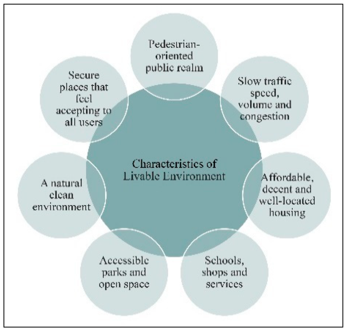
Figure 1. Characteristics of a livable environment (Source: the Authors).
Designs 05 00033 g001
Figure 2. Types of public space (Source: Gehl, J. Adapted from [26,27].
Designs 05 00033 g002
Figure 3. Types of activities typical of a TOD (Source: Calthorpe, P. Adapted from [6]).
Designs 05 00033 g003
Figure 4. Doha expansion projects, including (upper left) a map of major projects in the city (Source: Furlan, R. Adapted from [31]), three photos of Lusail City (Source: Manfred, T. Adapted from [32]), and (lower right) Doha’s port (Source: Ruskin Titus Gulf. Adapted from [33]).
Designs 05 00033 g004
Figure 5. Structure of the research project’s framework (Source: the Authors).
Designs 05 00033 g005
Figure 6. The Doha waterline in 1956 and 2003 (Source: Wiedmann, F., et al. Adapted from [29]).
Designs 05 00033 g006
Figure 7. The location of West Bay metro station, shown within Qatar maps at different scales (Source: Google Earth, edited by the Authors).
Designs 05 00033 g007
Figure 8. Doha’s metro lines, the metro Red Line, and West Bay metro station (adapted from [5], edited by the Authors).
Designs 05 00033 g008
Figure 9. The design criteria used in the site analysis and design proposal (Source: the Authors).
Designs 05 00033 g009
Figure 10. Land uses in the study area and photos of adjacent buildings (Source: the Authors).
Designs 05 00033 g010
Figure 11. Different tower prototypes (Source: the Authors).
Designs 05 00033 g011
Figure 12. Graze Café and Monoprix hypermarket and café, on the ground floor of Palm Towers (Source: the Authors).
Designs 05 00033 g012
Figure 13. (left) Al Abraj Park, next to the State Audit Bureau building; (right) the park next to Qatar Cool Tower (Source: the Authors).
Designs 05 00033 g013
Figure 14. (left) Doha’s Corniche; (right) Sheraton Park (Sources: DohaLife. Adapted from [35]).
Designs 05 00033 g014
Figure 15. Characteristics of the vegetation at the study site, categorized in relation to ground use balance (Source: the Authors).
Designs 05 00033 g015
Figure 16. Desirable attributes of open and recreational areas (MME, 2020).
Designs 05 00033 g016
Figure 17. Various street prototypes at the study site, categorized in relation to walkability (Source: the Authors).
Designs 05 00033 g017
Figure 18. Various street prototypes in cross section (Source: the Authors).
Designs 05 00033 g018
Figure 19. (left) map showing building density; (right) condition of buildings in the study area (Source: the Authors).
Designs 05 00033 g019
Figure 20. Transportation map showing bus routes and metro line; the “M” in the red circles stands for “metro” (Source: the Authors).
Designs 05 00033 g020
Figure 21. (left) Bicycle path at the study site; (right) bus catchment area (Source: the Authors).
Designs 05 00033 g021
Figure 22. Illustration of poor connectivity, unshaded walkways, and lack of street crossings (Source: the Authors).
Designs 05 00033 g022
Figure 23. An illustration of how bus stops have begun changing in recent years (Sources: Central Planning Office of Ministry & Municipality of Urban Planning, Qatar. Adapted from [41]).
Designs 05 00033 g023
Figure 24. Illustration of the concept of green corridors; the red circle with the “M” shows the location of the West Bay metro station (Source: the Authors).
Designs 05 00033 g024
Figure 25. New proposed street cross section, aiming to achieve a multimodal transportation system that is integrated with outdoor spaces (Source: the Authors).
Designs 05 00033 g025
Figure 26. Illustration of solid (i.e., buildings, colored yellow) and void (car parking, colored black) areas. The red circle with the “M” shows the location of the West Bay metro station (Source: the Authors).
Designs 05 00033 g026
Figure 27. 3D illustration of new land uses (Source: The Authors).
Designs 05 00033 g027
Figure 28. 3D illustration of the proposed mixed-use development. The dotted red circles with an “M” show the location of entrances to the West Bay metro station (Source: the Authors).
Designs 05 00033 g028
Figure 29. (left) Bus stop in West Bay with solar panel (source: the Authors); (right) bus stop with solar roof, recommended for the study site (Source: Yeroo Group. Adapted from [42]).
Designs 05 00033 g029
Figure 30. (left) Ezdan Tower; (middle) proposed use of Islamic patterning on vegetation box and fountain; (right) use of Islamic patterning on a metro pedestrian link (Source: the Authors).
Designs 05 00033 g030
Figure 31. (left) David Cameron, former Prime Minister of the UK, using the London metro (Sources: The Friday Times. Adapted from [43]); (right) Mark Rutte, Prime Minister of the Netherlands, traveling by bike (Sources: Invest in Holland Network. Adapted from [44].
Designs 05 00033 g031
Publisher’s Note: MDPI stays neutral with regard to jurisdictional claims in published maps and institutional affiliations.