1. Introduction
Aquaculture offers a tremendous potential for providing sustainable food sources, thus playing a key role in achieving food and nutrition security, employment, and economic development in all coastal areas [
1]. It is one of the fastest growing food-producing sectors in the world and is the main source of fish for human consumption, with its contribution to world fish production growing continually [
2]. Aquaculture is also considered an essential element for the agenda of the European Union on Blue Growth and a strong contributor to some of its key Sustainable Development Goals (SDG 2. Zero hunger; SDG 12. Responsible consumption and production; SDG 14. Life below water [
3]). This is particularly true in geographical areas where the dependence of local economies on fishery products is high but access to sustainable landings is hindered by environmental drawbacks, such as the Black Sea basin. Whereas the Black Sea annual capture fishery production has varied considerably since the 1990s, growing attention is currently given to boosting aquaculture development along the Black Sea bordering countries, with marine aquaculture being considered an important contributor to the total fishery production [
1]. Nonetheless, aquaculture development in this region is not homogeneous, and its development has, so far, been limited by environmental, economic, social, and more generally, governance issues [
1].
Environmental and ecological factors (e.g., currents, temperature, salinity, nutrient input, pollutants, etc.) are essential when considering the selection of suitable sites for aquaculture. Being a large and diverse environment, the Black Sea offers different degrees of suitability for aquaculture development, and this is reflected in the way the aquaculture industry has developed in the different riparian countries [
1]. While the southern and eastern coasts are sheltered enough to allow for the development of large-scale aquaculture activities (mainly on the Turkish coast, which abounds in floating cages for European seabass, rainbow trout, and Black Sea trout), the north-western shoreline is rather smooth and characterized by wide environmental factors’ fluctuations and the strong influence of the Danube [
4], thus being challenging for any mariculture pursuit [
1]. Moreover, a rigid legislative framework has also hindered the development of marine aquaculture in the region—in Bulgaria [
5] and, particularly, in Romania [
6]. However, in recent years, more and more emphasis has been placed on the potential of mariculture, and, along with regional cooperation in the frame of the General Fisheries Commission for the Mediterranean (GFCM), through the Aquaculture Demonstrative Centers, local research and scientific consultancy activities have been carried out to foster the development of the field [
6].
At the EU level, the Common Fisheries Policy Regulation requires Member States to prepare multi-annual national strategic plans for aquaculture, intended to include investment priorities for aquaculture under the European Maritime and Fisheries Fund (EMFF) [
7]. Black Sea Member States have complied accordingly: in Bulgaria, the Executive Agency of Fisheries and Aquaculture (EAFA) administers the planning regime for aquaculture and the Act on fisheries and aquaculture determines the criteria for zoning [
8], while in Romania the competent authority, the National Agency for Fishery and Aquaculture (NAFA), has published a Strategy for Fishery and Aquaculture with clear aquaculture zoning instructions [
9].
The major issue that hampered the development of marine aquaculture in Romania was represented by the unclear and restrictive legislative framework (the lack of microbiological classification of Black Sea waters as required by European regulations [
10]), which prevented any potential economic operator from marketing the production of bivalve mollusks in the European Union for public health reasons. The microbiological survey was completed in 2020, and all three production and relaying areas of live bivalve mollusks in the Romanian sector of the Black Sea were included in class A, which opens up huge opportunities for bivalve aquaculture on the Romanian coast [
11]. In addition, the concession of the Black Sea waters for the implementation of aquaculture activities became possible through Government Decision No. 1283 for the amendment and completion of Government Decision No. 183/2020 regarding the approval of the lease of public property of the state, under the administration of the Romanian National Water Administration, opening immense development opportunities [
12].
The long-awaited settlement of the legislative framework for the concession of marine waters has also unlocked the activity of finfish mariculture in floating cages on the Romanian coast, considering that several economic operators have expressed interest in the alternative rearing of rainbow trout
Oncorhynchus mykiss (Walbaum, 1792) in seawater during the cold period of the year (in floating cages, located in the open sea), in order to improve meat quality and increase economic efficiency [
13]. Moreover, other finfish species could be considered for aquaculture in the open sea, such as seabass and sturgeons [
5].
In the Black Sea, the development and expansion of marine aquaculture depends on the availability of space to develop this activity in a sustainable way, even more so in the case of the Romanian coast, characterized by hindering environmental conditions (very few sheltered areas, strong storms, variable salinity, and temperature). Environmental factors have a decisive influence on the growth and development of all marine organisms, including cultured finfish, so they are essential in any approach to the farming of these species [
14]. The culture of marine organisms in the Romanian coastal area is conditioned by the creation of marine equipment that can withstand the hydrometeorological conditions specific to the Black Sea [
15]. Additionally, the extension and creation of new Natura 2000 sites were made by overlapping with pre-existing traditional economic activities, mainly fishing, but also other uses of the maritime space [
16]. Allocated Zones for Aquaculture (AZAs) are therefore an essential tool towards the sustainable development of mariculture, and they have a special role to play in maritime spatial planning in an area as limited and crowded by uses as the Romanian coast [
17].
An AZA is a maritime area where the development of aquaculture takes precedence over other uses and will therefore be dedicated primarily to aquaculture [
18,
19,
20,
21]. The identification of an AZA results from the zoning processes of participatory spatial planning, through which administrative bodies establish that certain spatial areas in a region have priority for the development of aquaculture. In order to support the process of AZA designation, the General Fisheries Commission of the Mediterranean (GFCM) of the Food and Agriculture Organization of the United Nations (FAO) adopted a specific resolution (Res. GFCM/36/2012/1) to provide guidelines to the countries [
22]. The implementation of AZA as well as the coordination among the different authorities involved in aquaculture and planning have been identified as priorities during the “High-level Conference towards Enhanced Cooperation on Black Sea Fisheries and Aquaculture,” held in Bucharest, Romania, in 2016 [
23], and the proposed methodology is being applied all around the Mediterranean basin [
19,
20,
21]. Moreover, extensive research has been performed internationally in order to establish an optimal methodology for aquaculture area selection and designation [
24,
25,
26].
In Romania, an initial step towards potential AZA identification was performed by investigating the Agigea—Eforie area, considering different farming systems and the interaction of aquaculture activities with the environment, social, and economic aspects, and assessing the level of interest of this area for developing mariculture activities based on the Degree of Compatibility (DC) [
19,
27]. The results of this first study indicated the excellent suitability of the area for performing shellfish aquaculture [
17].
Further, the objective of this study was to analyze, by applying and adapting a well-documented and internationally endorsed methodology [
19,
27], the level of interest and the Degree of Compatibility (DC) of the first area suitable for practicing finfish farming in offshore floating cages in order to foster the development of the sector in Romania and, by extension, the north-western Black Sea region. The rationale for this novel research pursuit is the desire to unlock the potentiality of Black Sea aquaculture by providing scientific support to the competent authorities for the settlement of legislation and governance issues.
2. Materials and Methods
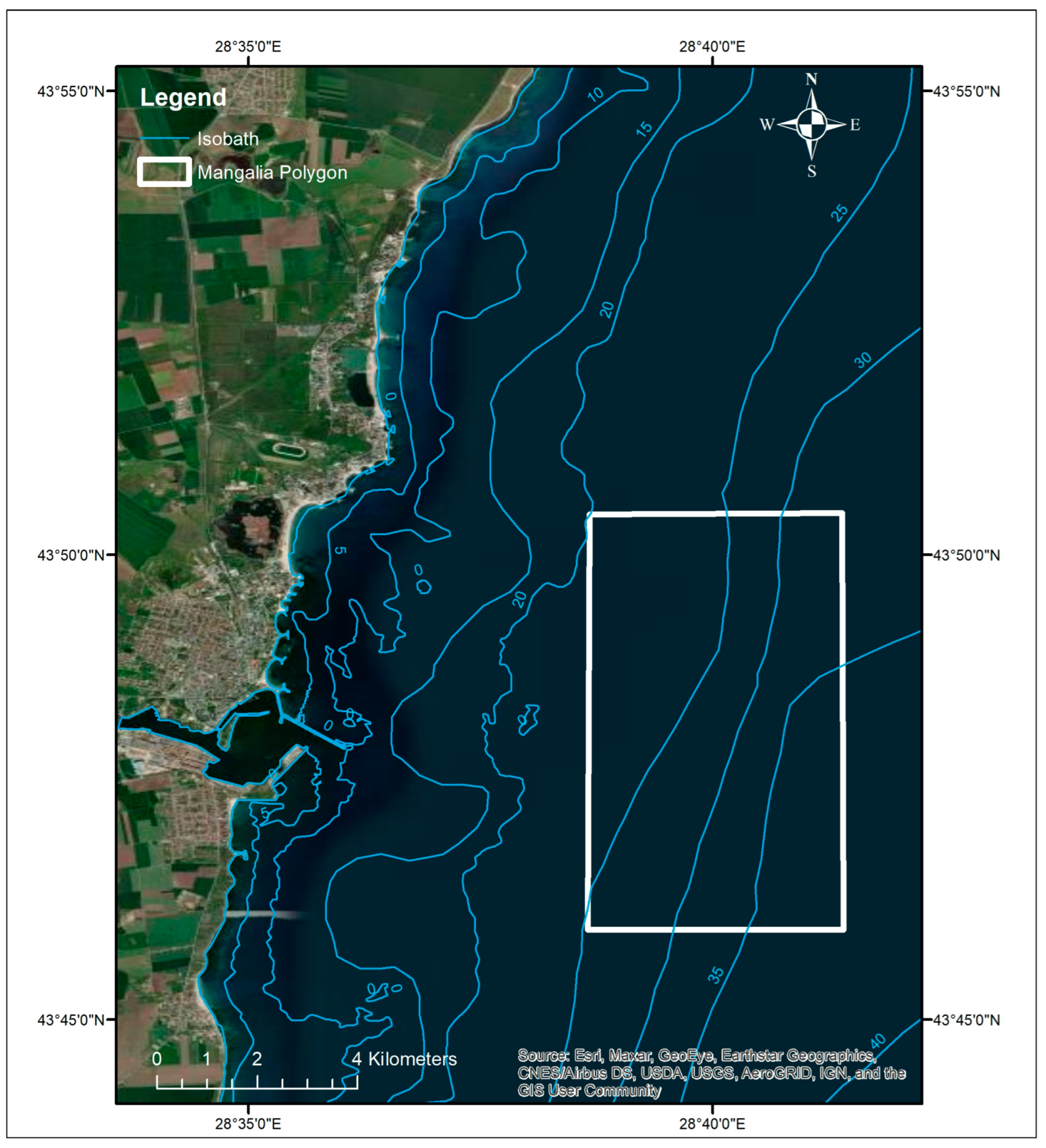
The rectangular polygon investigated in this study is located in the southern part of the Romanian coast, off the Mangalia Port, and covers 3050 ha (
Figure 1). The distance from the shore to the center of the polygon is 6.6 km.
The selection of the study area (Mangalia, located in the southern part of the Romanian coast) was based on pre-selected criteria assessing its suitability for aquaculture development (
Table 1) [
19,
27], as well as on the interest of economic operators, who expressed their willingness to invest in this field of activity, and of policy makers, who considered the area for designation as the first AZA for finfish farming at the Romanian coast. The southern positioning of the site guarantees a lower variability of environmental parameters and less influence from the Danube [
4,
14].
As the proposed area qualified after this first pre-selection step, further on, the methodology used to delineate the most appropriate zone for cage aquaculture development was to assess the level of interest and estimate the DC of the pre-selected area [
19,
20,
27]. The DC allows the categorization of the study area with the aim of defining the suitability for the development of finfish aquaculture activities.
This categorization was carried out considering the parameters explained below (
Table 2). Each parameter has ranges or conditions assigned. A Suitability Index (SI) was established for each range of parameter considered in the study based on the available data. The SI can take four different values according to the potential influence of the range considered: −100 (exclusion criteria), −1 (unwise characteristic), 0 (moderate), or 1 (optimum characteristic). The weighting factor (K) ranges from 1 to 10, and the value assigned is directly proportional to the reliability and importance of each parameter [
27].
The parameters used to calculate the DC for the Mangalia area are summarized in
Table 2. The ranges and conditions considered for each parameter were adapted to the local specificity of the Romanian coast, while the SI and K were assigned for finfish according to the established methodology [
19,
27].
The compatibility (Parameter 1) of finfish aquaculture with other users of the maritime space in the Mangalia area was assessed as a follow-up to the analysis of all uses documented in the EMODnet Human Activities database [
28], the National Maritime Spatial Plan Draft [
29], and the MARSPLAN: BS-II project database (“Cross-Border Maritime Spatial Planning for Black Sea Bulgaria and Romania“) [
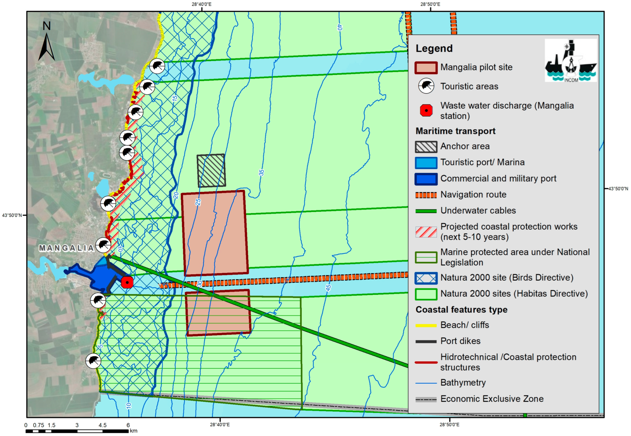
30], and subsequently visualized in an integrated map using GIS software (Figure 2 below).
Water depth (Parameter 2) in the area was retrieved from the EMODnet Bathimetry portal [
31]. To establish the bathymetric characteristics, the digital terrain model (DTM) produced within EMODNet Bathymetry was used, which includes both in situ measurements and data derived from satellite images and/or results from spatial modeling.
Regarding the wave regime, for the present study, both data obtained through numerical models, provided by the European Copernicus Marine Environment Monitoring Service (CMEMS) [
32], as well as in situ data obtained by NIMRD in the coastal area and data observed at the Gloria Platform, were used. For the medium swell (Parameter 3), the annual mean values for wave height in the area of interest provided by CMEMS are multi-year modeled data, reprocessed by the Black Sea Waves system based on the WAM spectral wave model, which has a horizontal resolution of 1/36° × 1/27° (approx. 3 km). For the needs of the study, datasets for a period of 10 years (2011–2021) were extracted in CSV and/or NetCDF format and visualized using ODV software [
33]. In addition, to investigate the wave regime specific to the Mangalia area, data from the WAM model was used for a point located in the offshore area, east of Cape Tuzla. Regarding the extreme swell (Parameter 4), the annual mean values for the maximum wave height was provided by CMEMS [
32], processed by the Black Sea Waves Analysis and Forecast system (BLKSEA_ANALYSISFORECAST_WAV_007_003), based on the WAM spectral model, with a spatial grid resolution of approximately 2.5 km (1/40° × 1/40°), data valid for the period 2020–2022. For the period 2012–2020, the maximum values of the waves extracted from the complementary data sets were taken into account, with the significant wave height as the main parameter (Hs), and reprocessed (BLKSEA_MULTIYEAR_WAV_007_006) [
32].
The average speed of currents (Parameter 5) in the Mangalia area was retrieved from CMEMS, the Black Sea physical reanalysis system, based on the NEMO general circulation model (version 3.6), implemented for the Black Sea, with a horizontal grid resolution of 1/27° × 1/36° and 31 vertical levels, with data available for the period 1993–2020 [
32]. For the period 2020–2022, the data set was completed with hydrodynamic data (ocean current distribution) extracted from the Black Sea Physical Analysis and Forecast System, BS-PHY NRT (EAS4 version), which provides the circulation/current configuration patterns for the Black Sea basin with time series starting from 2019, based on the NEMO hydrodynamic model for the Black Sea implemented with a horizontal resolution of 1/40° × 1/40° and 121 vertical layers [
34].
The variables used to estimate the Water Quality Index (WQI) (Parameter 6) were: dissolved oxygen (DO), temperature (T), salinity (S), total suspended solids (TSS), chlorophyll a (Chl a), and nitrites (NO2−).
Water quality data were collected during 16 research surveys in the period 2012–2021, between March and November. In situ measurements were performed, and water samples were taken from the stations of the national monitoring network located on the 20 m isobath (Mangalia 20-m included), with a frequency of 1–2 expeditions/year from the 0-m (surface) and 10-m horizons. The Mangalia station is located in an area with coastal water typology (cos BLK_RO_RG_CT). Considering the lack of data from the cold season (December–February), for better temporal coverage of the performed analysis, the daily data collected from the surface at the Cazino Mamaia station were also analyzed.
Dissolved oxygen was determined by the Winkler method (SR EN 25813:2000) according to the manual “Methods of Seawater Analysis“ [
35]. The method’s accuracy is 4.5 µM.
Temperature was measured with the reversible thermometer, or YSI Cast Away CTD, with an accuracy of 0.05 °C.
Salinity was measured in situ with the YSI Cast Away CTD or in the laboratory using the Mettler Toledo multiparameter or the Knorr-Knudsen method [
35]. The method’s accuracy is 0.1%.
The total suspended solids (TSS) content (STAS 6953–81) was determined by the gravimetric method (with a method accuracy of 0.1 mg).
Regarding chlorophyll
a (Chl
a), for the purpose of the present study, an estimate of the phytoplankton biomass in the area of interest was used, expressed by the maximum annual values of Chl
a over a period of 10 years, 2011–2021 [
36].
Nitrites (NO
2−) dissolved in seawater were quantified by the analytical spectrophotometric method, validated in the laboratory, and referred to in the manual “Methods of Seawater Analysis” [
35]. The detection limit is 0.03 µM and the extended relative uncertainty is 6.6% (k = 2, coverage factor, 95.45%). The Shimadzu UV-VIS spectrophotometer was used, with a measurement range of 0–1000 nm.
In order to calculate the WQI for the proposed area, the following Equation (1) was used (adapted from [
19,
27]):
where:
The minimum annual value of DO over a period of 10 years was used in the calculation.
= function for the variable Temperature (
Table 4)
The minimum annual value of T over a period of 10 years was used in the calculation.
Table 4.
The ranges used to assign values for seawater temperature.
Table 4.
The ranges used to assign values for seawater temperature.
| if | T min. (°C) |
| 10 | <10 |
| 20 − T min. | 10–20 |
| 0 | >20 |
Whereas salinity is a rather constant parameter, only with seasonal oscillations [
19], Equation (2) used for this variable was:
where:
= the standard deviation of salinity values from 2012–2021;
= average salinity from 2012–2021
For Total Suspended Solids (TSS), a natural logarithm of the maximum value for the period 2012–2021 was calculated (3):
= function for the variable Chlorophyll
a (
Table 5)
As an estimate of phytoplankton biomass in the area, the maximum value for chlorophyll
a was used [
36].
Table 5.
The ranges used to assign values for chlorophyll a.
Table 5.
The ranges used to assign values for chlorophyll a.
| if | Chlamax.(µg/L) |
| 10 | ≥15 |
| <15 |
= function for the variable Nitrites (NO
2−) (
Table 6)
The value used for the nitrite function calculation represents the maximum concentration of nitrites recorded in the area during 2012–2021.
Table 6.
The ranges used to assign values for nitrites.
Table 6.
The ranges used to assign values for nitrites.
| if | NO2− max.(µM) |
| 10 | ≥10 |
| NO2− max. | <10 |
The bionomic assessment (Parameter 7) of the proposed AZA was performed by expert judgement, considering the overall ecosystem value of the Mangalia area with regard to sediment type, associated biocoenoses, sensitive habitats, and biodiversity in general, referring to the management plans of the relevant marine protected areas in the vicinity [
37,
38].
For the characterization of the seabed (Parameter 8), data from EUSeaMap 2021 (EMODNet Seabed Habitats) [
39] was used, which complied with the EUNIS classification [
40] and is in accordance with the provisions of the Marine Strategy Framework Directive [
41], both of which are based on the modified Folk method (hard substrate—stone/biogenic habitats; and soft substrate—sand, silt, mixed, and coarse sediments). The EUSeaMap (2021) layer of spatial data has a resolution of ~100 × 100 m, obtained by large-scale modeling and the aggregation of available information.
All spatial data was integrated into a GIS system, for spatial analysis and map creation.
Finally, in order to quantify the Degree of Compatibility (DC) of the proposed AZA for each parameter considered in
Table 2 above, the following formula (4) was applied, adapted from [
19,
27].
where: DC = Degree of Compatibility;
K = Weighting Factor applied to each parameter considered;
SI = Suitability Index applied in the area according to the potential influence of each parameter;
i = parameter;
n = number of parameters
According to the DC estimation, the result can be classified and delineated according to the following table (
Table 7):
3. Results and Discussion
3.1. Uses Compatibility
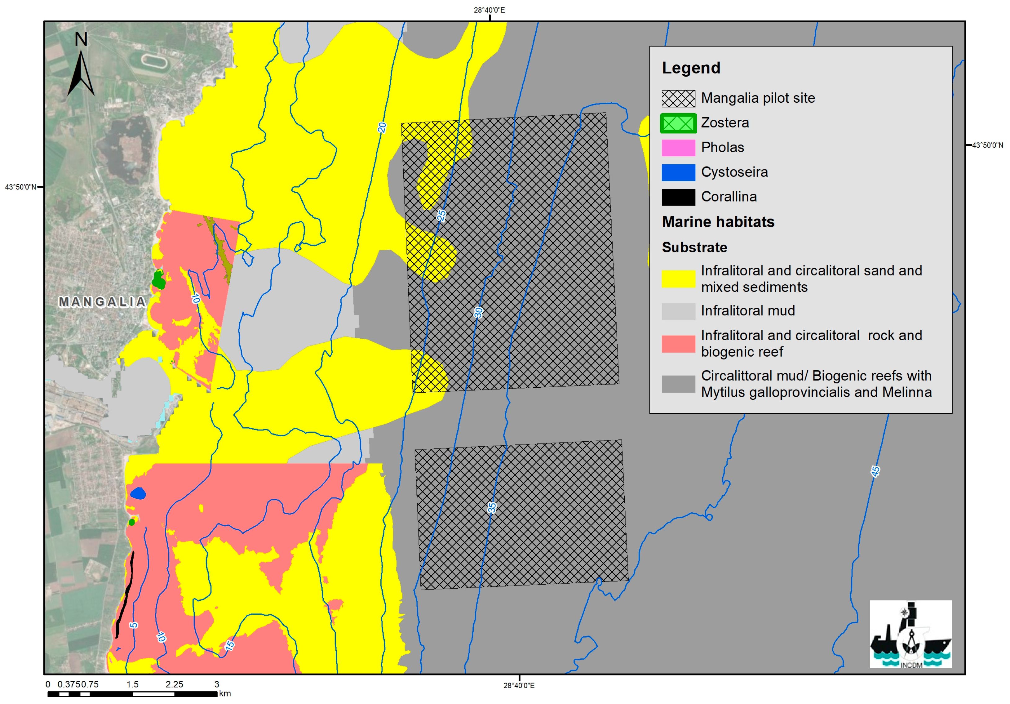
Analyzing all the activities in the area (
Figure 2), it can be concluded that in most of the pre-selected polygon in Mangalia there are no major potential conflicts with other uses of the maritime space, with the selected area for potential AZA designation not overlapping with fishing areas, military areas, or other types of activities that could be incompatible with aquaculture. The only issue to be taken into account is the navigation route corridor of the Mangalia Port (1 km wide) that crosses the selected polygon, which shall be excluded from the proposed AZA. As a follow-up, the Mangalia AZA can be divided into 2 sub-areas: a northern zone suitable for large-scale farming installations and a southern zone appropriate for small-scale/family farming operations.
Moreover, no possible sources of contamination were identified nearby the selected zone, the Mangalia Wastewater Treatment Plant (WWTP) discharging inside the Mangalia Port. The Mangalia WWTP, located in the southern part of the city, serves the city and the neighbouring tourist resorts. The designed capacity of the treatment station is 900 L/s, and it treats the water mechanically and biologically. The receiver of the water discharged by the treatment station is the area of the Black Sea downstream of the Mangalia Port, near the station; the treated wastewater is discharged through a pipe with a diameter of 1200 mm, located 4 m from the shore, at a water depth of 2.5 m, thus very close to the shore and not influencing the selected polygon, which is located more than 6 km away from the discharging pipe [
42].
Consequently, for this parameter, a Suitability Index = 1 was assigned.
3.2. Depth
In the southern part of the Romanian littoral, mudflats with rocks fallen from cliffs and sediment cells are present, covering areas of hard calcareous substrate represented by the Sarmatian plate. The main factors that determine the underwater landscape are generally represented by natural factors through the regime of waves and sea currents, but also by the anthropogenic factor through coastal protection works and beach expansion. Located outside a complex bathymetric area with submerged promontories and canyons, the bathymetry in the Mangalia area of interest is relatively uniform and symmetrical on the diagonal of the polygon. The area roughly symmetrically encompasses the 25 and 30 m isobaths in the NE and SE corners, extending to depths of 20 and 37 m, respectively.
The average water depth related to the total area of the polygon is approximately 33 m (
Figure 3), which is excellent for finfish cage farming and accounts for a Suitability Index = 1.
Water depth is an essential parameter in designing cage facilities [
27]. The most appropriate depth for installations at sea is the one that allows the technical feasibility of facilities, on the one hand, and that allows the body of water to flow and thus facilitate oxygenation and dispersion of the inputs, on the other hand [
19]. Depth varies depending on different parameters, including the species, farming method, and the distance between the floor of the cages and the sea bottom. Most installations anchored in the Mediterranean countries are located between 20 and 100 m deep [
19].
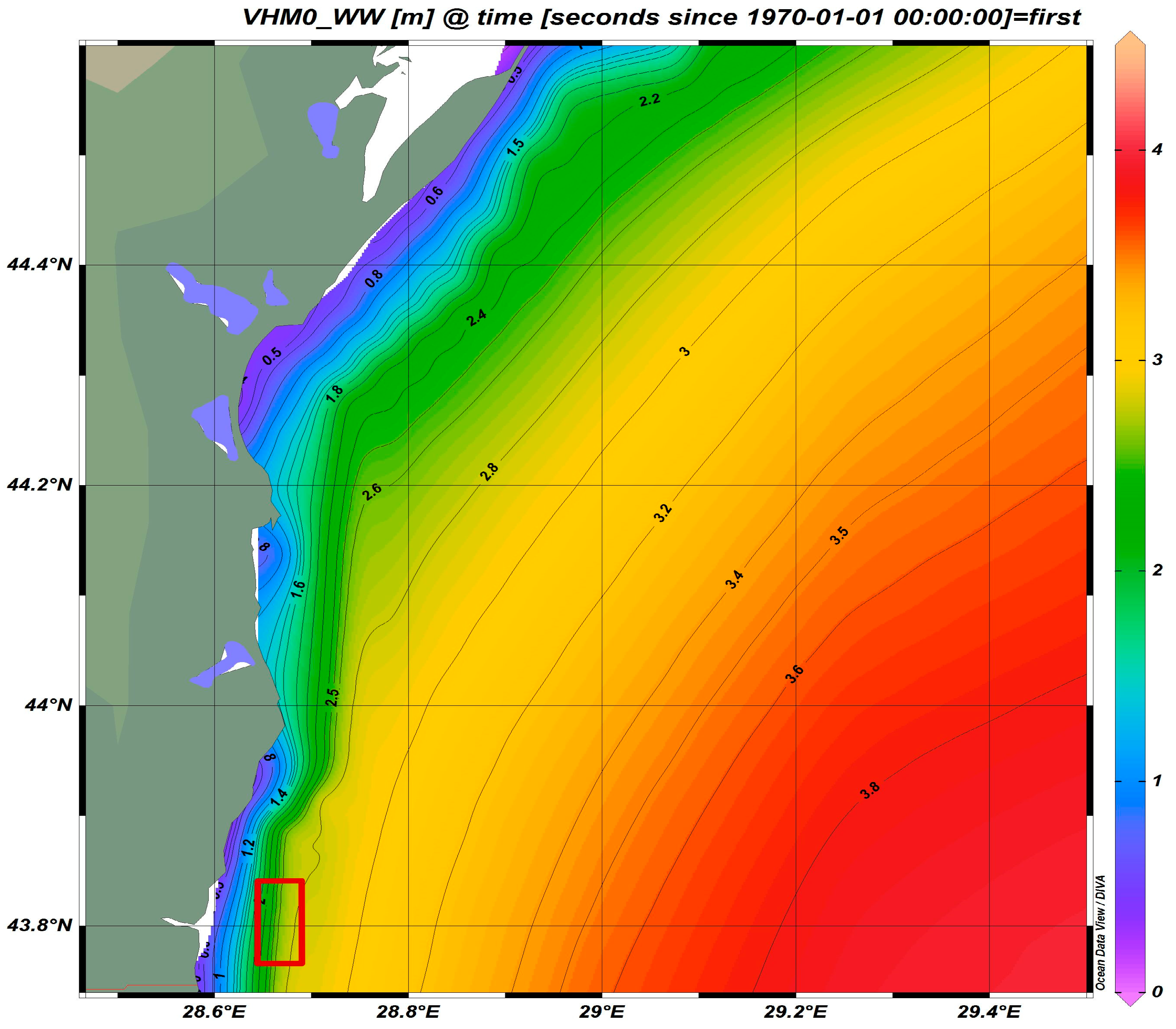
3.3. Medium Swell
Medium swell (significant wave height) is the average wave height, from trough to crest, of the highest one-third of the waves, and this parameter, measured in meters, allows the most appropriate technology to be selected for each area in relation to its technical feasibility [
19].
On the Romanian littoral, the regime of waves is associated with the regime of winds, and consequently, the field of waves generated by the wind, especially in the coastal area, depends on the local peculiarities (direction, duration, and intensity of winds).
The medium swell (wind waves) in the Mangalia area recorded values of 1.5–2.8 m during the investigated period (2011–2021) (modelled data provided by CMEMS [
32]) (
Figure 4), thus accounting for a Suitability Index = 1.
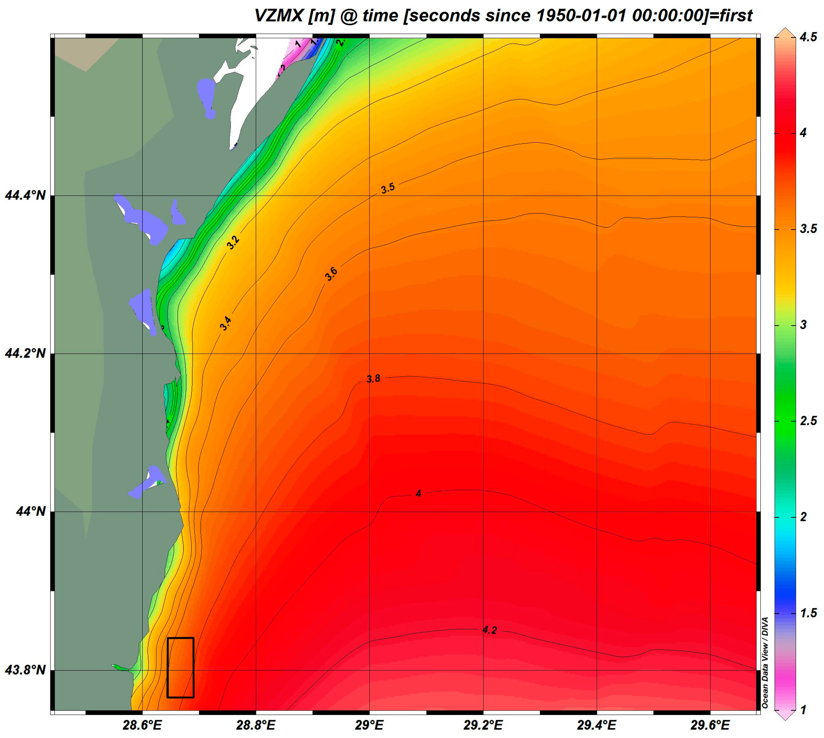
3.4. Extreme Swell
The maximum wave height for the study area ranged between 3.5–4 m (modelled data provided by CMEMS [
32];
Figure 5), which results in a Suitability Index = 0.
Typically, at the Romanian coast, the most impactful waves occur in December and January and the mildest in June and July. The predominant direction of the waves, with determining influence, is north-east during the winter and south-east during the summer season (especially for the southern part of the coastal area).
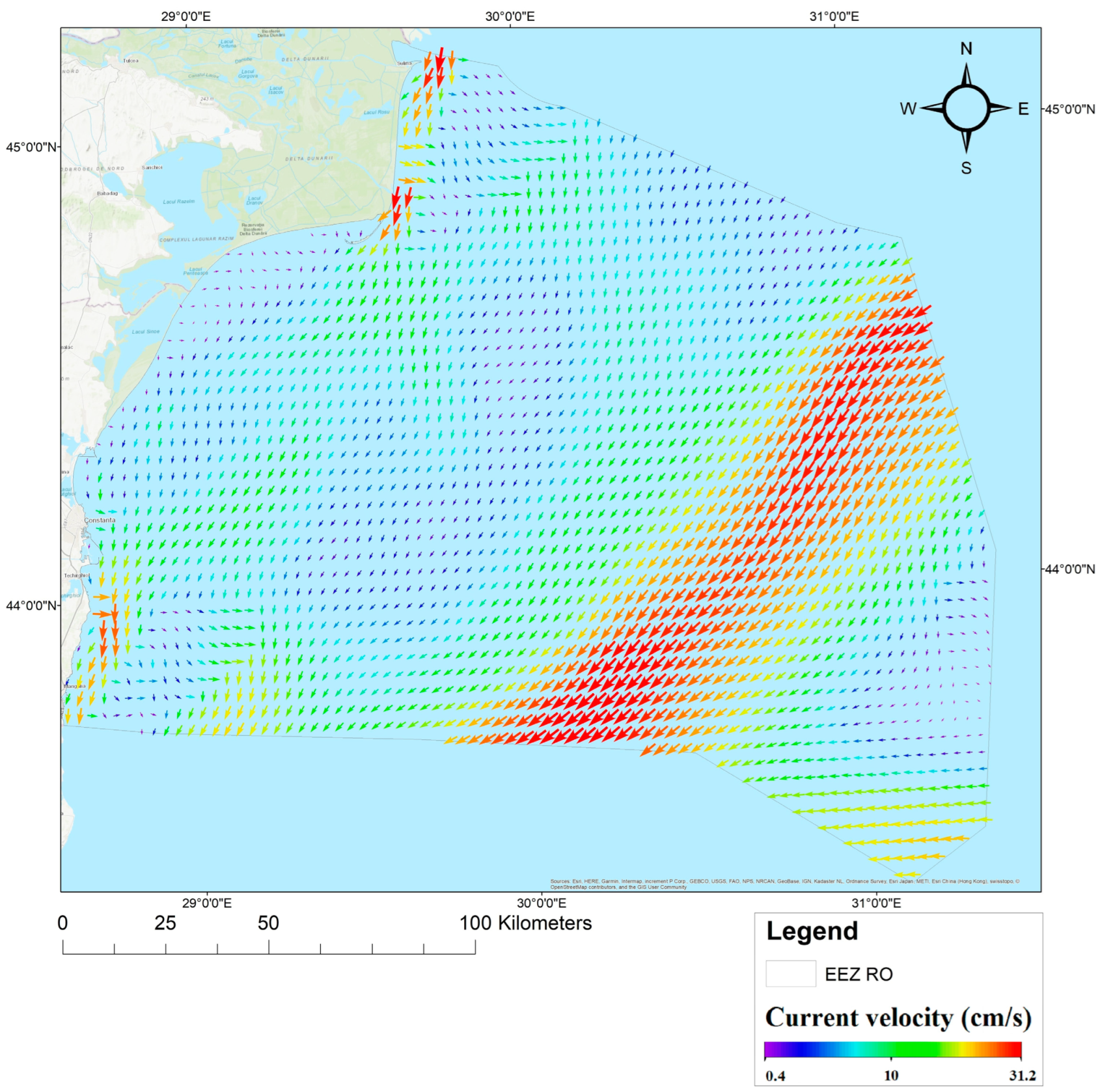
3.5. Average Speed of Currents
Similarly to the wave regime, the marine current regime is variable in the Romanian coastal area, owing to the influence of the winds and climate variability, respectively. A system of intense non-linear interactions on a regional and sub-regional scale is noticeable, with dynamic structures of water bodies, such as eddies, fronts, and jets, of crucial importance for the circulation dynamics, both in the coastal area as well as in the offshore marine area of Romania.
The mean values of the intensity of surface currents for the area of interest in Mangalia for the period 2011–2021 ranged between 10–20 cm/s (
Figure 6); thus, for this parameter, the selected polygon scored a Suitability Index = 1. This parameter will allow the positioning of facilities in the best direction with respect to the currents affecting the water quality. At the same time, sea currents are important for spreading waste away from cages. Current speed is measured in meters per second, while current direction is defined using the cardinal points [
19].
3.6. Water Quality Index (WQI)
As mentioned above, the variables used to estimate the WQI were: Dissolved Oxygen (DO), Temperature (T), Salinity (S), Total Suspended Solids (TSS), Chlorophyll
a (Chl
a), and Nitrites (NO
2−) [
14,
19].
The minimum value of DO in the investigated area was 7.7 mg/L (mean value between the values of samples collected during both the cold and warm seasons of 2012 to 2021). Applying the equation, the score for = 0.
Regarding seawater temperature during 2012–2021, the minimum value in the area was 7.42 °C. As such, the score for = 10.
For salinity, using the standard deviation of 2.47‰ and the average of 15.60‰ in the past 10 years of data records, the result for = 1.58.
For Total Suspended Solids (TSS), the result of the natural logarithm of the maximum value (25.20 mg/L) was 3.22.
As an estimate of phytoplankton biomass in the area, the maximum value for chlorophyll a in 2012 was 55.94 µg/L; thus, the score for = 10.
For nitrites, the maximum value recorded in the area was 20.44 µM (average of peak values recorded during the cold and warm seasons during 2012–2021). As such, the score for = 10.
Ultimately, applying the WQI equation (1), the result for the Mangalia area was 4.2, which results in a Suitability Index = 0 for this parameter. Thus, the water quality in the Mangalia area is appropriate for supporting finfish aquaculture activities.
3.7. Bionomic (Ecosystem Value)
The conservation of habitats and species of high ecological value and the maintenance of ecological biodiversity and water quality can improve the social acceptance of aquaculture. In this light, the ecosystem value of the proposed site (Mangalia) was assessed in relation to the presence/absence of highly valuable/sensitive species and habitats. The presence of habitats of special interest and/or protection, such as sea grass meadows or others listed in the Habitats Directive, was taken into account [
19]. Despite the fact that the proposed Mangalia AZA overlaps with two Natura 2000 marine protected areas (MPAs), namely ROSCI0094 Mangalia Sulphide Seeps and ROSCI0269 Vama Veche—2 Mai, there is no foreseen conflict with nature conservation, as no sensitive and/or essential habitats and species are located within the polygon (
Figure 7).
All species with high conservative values reported in the two MPAs [
37,
38], namely the brown perennial alga
Treptacantha (Cystoseira) barbata (Stackhouse) Orellana & Sansón, 2019, the marine phanerogam
Zostera noltei Hornemann, 1832, the red coral weed
Corallina officinalis Linnaeus, 1758, as well as the common piddock
Pholas dactylus Linnaeus, 1758, are all encountered in shallow areas close to the coast, with any potential harmful influence from finfish cages (nutrient enrichment due to fish feeding/excretion, physical impact of the cage mooring systems, etc.) [
43] being excluded. The possible threats to the local environment (such as uneaten food and feces sinking to the bottom beneath cages, which may affect water quality, kill stock affect seabed habitats) [
1] are extremely low, due to optimal water depth and strong circulation of currents. As a consequence, this parameter scored a Suitability Index = 1.
3.8. Seabed
The characterization of the seabed is essential for identifying the most suitable places for installing aquaculture facilities. This allows potential negative impacts to be avoided in sensitive habitats while providing vital environmental data on the biological and chemical status of the proposed location before installation [
19].
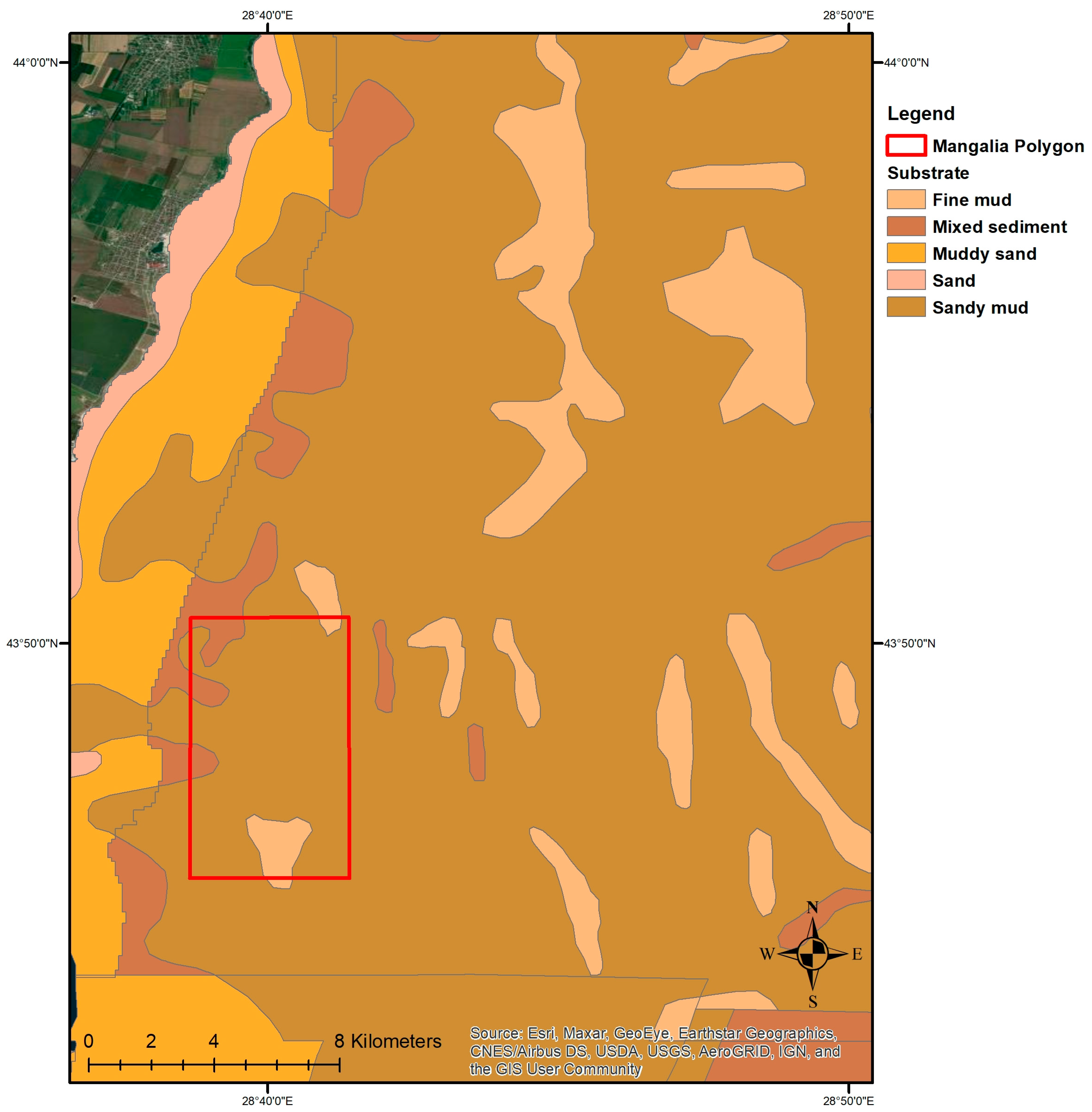
As a general rule, the marine sediments in the area of the Romanian continental shelf are mainly composed of sand (in the infralittoral area), silt, mixed, and shelly deposits. In the shallow area, sand predominates, with an extension up to the isobath of 5–10 m in the northern and central sectors and up to depths of 20–30 m in the southern area, interbedded with hard substrate as a result of the presence of the calcareous plate. The sediments on the continental shelf at greater depths are generally silts, interrupted by mixed sediments. In the southern unit of the coast, there is also a hard, calcareous substrate in the form of isolated rocks or submarine slates, located predominantly in the 2 Mai—Vama Veche area [
44].
In the southern part of the coast, the substrate is generally formed by consolidated formations specific to the Sarmatian plate, covered mainly by sandy silt/mud in most of the Mangalia polygon (85%), with islands of mixed and clayey sediments (fine silt) [
45] (
Figure 8).
The seabed structure in the Mangalia area is appropriate for mooring/anchoring cage farming facilities; thus, this parameter is assigned a Suitability Index = 1.
Ultimately, the scores of all eight parameters taken into account are summarized in
Table 8 below:
3.9. Degree of Compatibility (DC) Calculation
Finally, all the scores obtained and the associated weighting factors were integrated into the DC equation (4), and the obtained score was 80. The result (30 < 80 < 100) (high DC, according to [
19,
27]) clearly indicates the Mangalia area as suitable for finfish aquaculture activities: there is no major interference with other uses of the maritime space, no conflicts with nature conservation, and the environmental conditions are appropriate for fish culture in floating cages.
3.10. Integration into the Legislative Framework
The final step of this research endeavour would be the establishment of the Mangalia AZA for finfish farming by integration into the Romanian legislative system. The zoning process for the formal and official establishment should follow a participatory approach, be transparent, be coordinated by the responsible authority (in Romania, the National Agency for Fisheries and Aquaculture—NAFA), and be carried out in cooperation with the different authorities involved in aquaculture licensing and leasing procedures and monitoring (the Romanian National Sanitary Veterinary and Food Safety Authority, the Romanian Waters National Administration, etc.).
According to the draft of the Romanian Aquaculture Law [
46], the allocation/establishment of aquaculture zones, the identification of existing or potential sites, and the functional structure of finfish/shellfish facilities must consider the social, economic, environmental, and governance objectives of sustainable development, regardless of the holder of the management rights or use of the body of water. The designation of Allocated Zones for Aquaculture is done at the proposal of NAFA by government decision. NAFA registers all designated AZAs as well as the related production capacities in the Register of Aquaculture Operators and Units (RAOU). Information on aquaculture areas is public and is provided in spatial coordinates in GIS format.
The novel data provided by this study can be the building block for Romanian authorities to settle the governance gap that has so far impeded the development of marine aquaculture in Romania. At a larger scale, this study can serve as a good practice example at the regional Black Sea level, as the adapted methodology can be applied by other riparian countries for AZA designation.
Moreover, in order to harmonize future administrative, legislative, and livelihood issues in the northwestern Black Sea area, aquaculture management areas (AMAs) should also be considered. An AMA is an aquaculture area within a zone where farms share a common water body or water source and that may benefit from a common management system aimed at minimizing environmental, social, and fish health risks [
5].
4. Conclusions and Recommendations
Mariculture is part of marine spatial planning in many regions of the world, based on different administrative approaches. The best scenario is that the spatial expansion of marine aquaculture is nested within the broader context of marine spatial planning to minimize adverse impacts on the environment and biodiversity and to preserve ecosystem services at a regional scale.
Alternatively, the selection of AZAs could be carried out by specific aquaculture spatial planning bodies, or site selection could even be made on a case-by-case basis, considering environmental and social aspects at the local scale. This is the actual case of this study, as the investigation of the suitability of the Mangalia area for finfish cage farming was made on the one hand due to its positive response to pre-selection and, on the other hand, due to the actual market demand (potential investors) and policy makers’ intentions.
Applying an adapted methodology for AZA designation at the Romanian coast, eight parameters [compatibility, water depth, medium swell, extreme swell—storm, average speed of currents, Water Quality Index (WQI), bionomic (ecosystem) value, seabed] were included in the calculation. All in all, the results obtained for the Mangalia area (DC = 80) are optimal for establishing it as the first AZA for finfish farming in the Romanian Black Sea, as well as encouraging good examples to be showcased at the regional level.
Our findings and the adapted methodology shall represent a useful tool for Romanian authorities in settling the legislative framework, by providing essential information for a potential AZA designation. The management of marine aquaculture in the north-western Black Sea region should be ecosystem-based, balancing ecological, economic, and social objectives for sustainable development; thus, national authorities in charge of coastal zone management must use spatial planning to identify suitable AZAs and implement them more widely. The inclusion of aquaculture in spatial plans as a framework for the establishment of AZAs will help avoid negative externalities, provide business opportunities, and mitigate environmental degradation, while fostering the development of coastal areas.
It is clear, however, that the designation of an AZA is not enough to guarantee sustainable aquaculture. Within an AZA, the specific site selection and the production per site must match ecosystem carrying capacities, and a permanent monitoring programme within the relevant water body is absolutely needed to assess the impacts of each individual farm.


