A Set of Ground Penetrating Radar Measures from Quarries

 ,
,  and
and
Abstract
1. Summary
2. Site Description
2.1. Botticino Quarry (Italy)
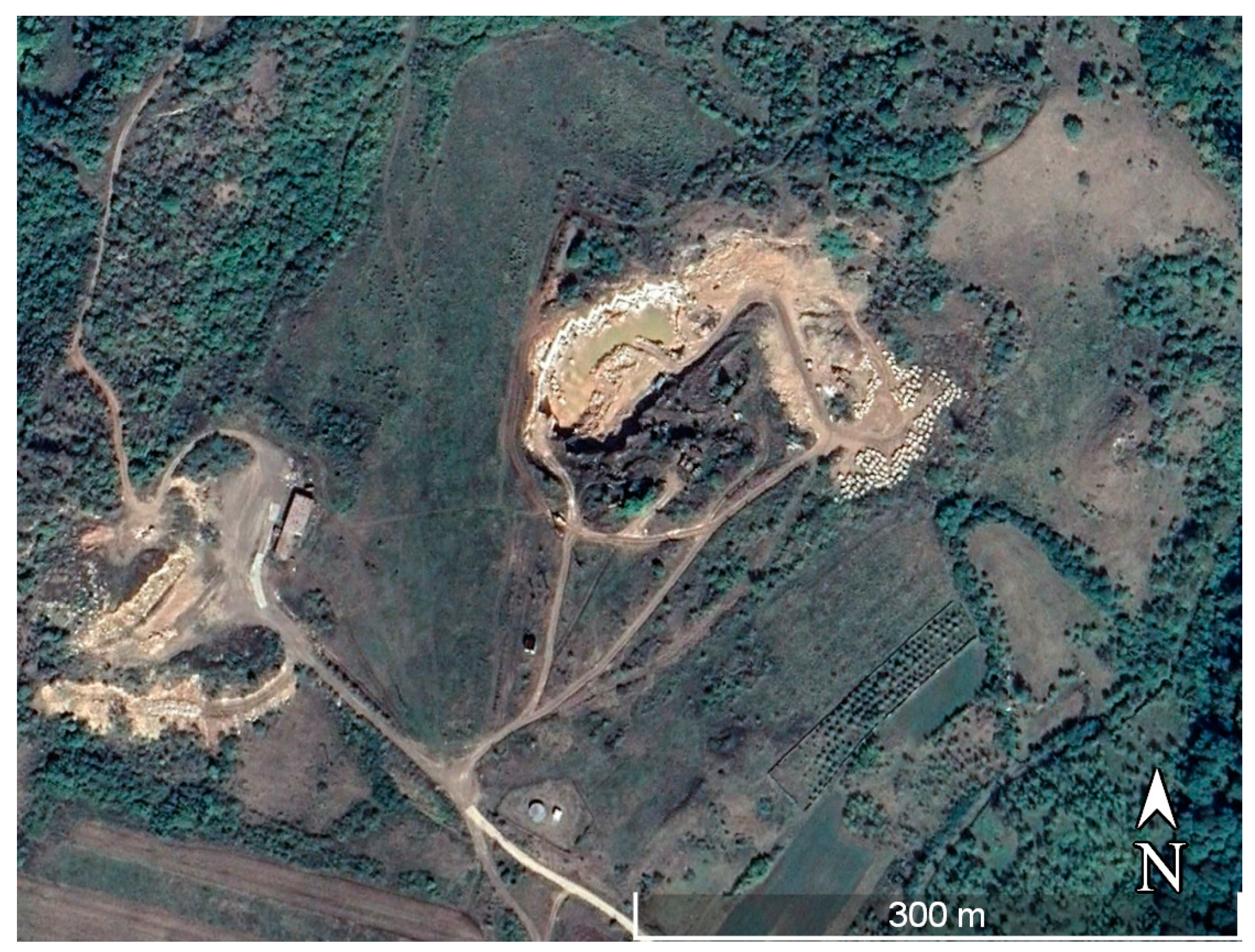
2.2. Ruschita Quarry (Romania)
2.3. Carpinis Quarry
2.4. Pietroasa Quarry
3. Data Description
3.1. GPR Data: Italy
Instrument Description
3.2. GPR Data: Romania
Instrument Description
4. Data Acquisition
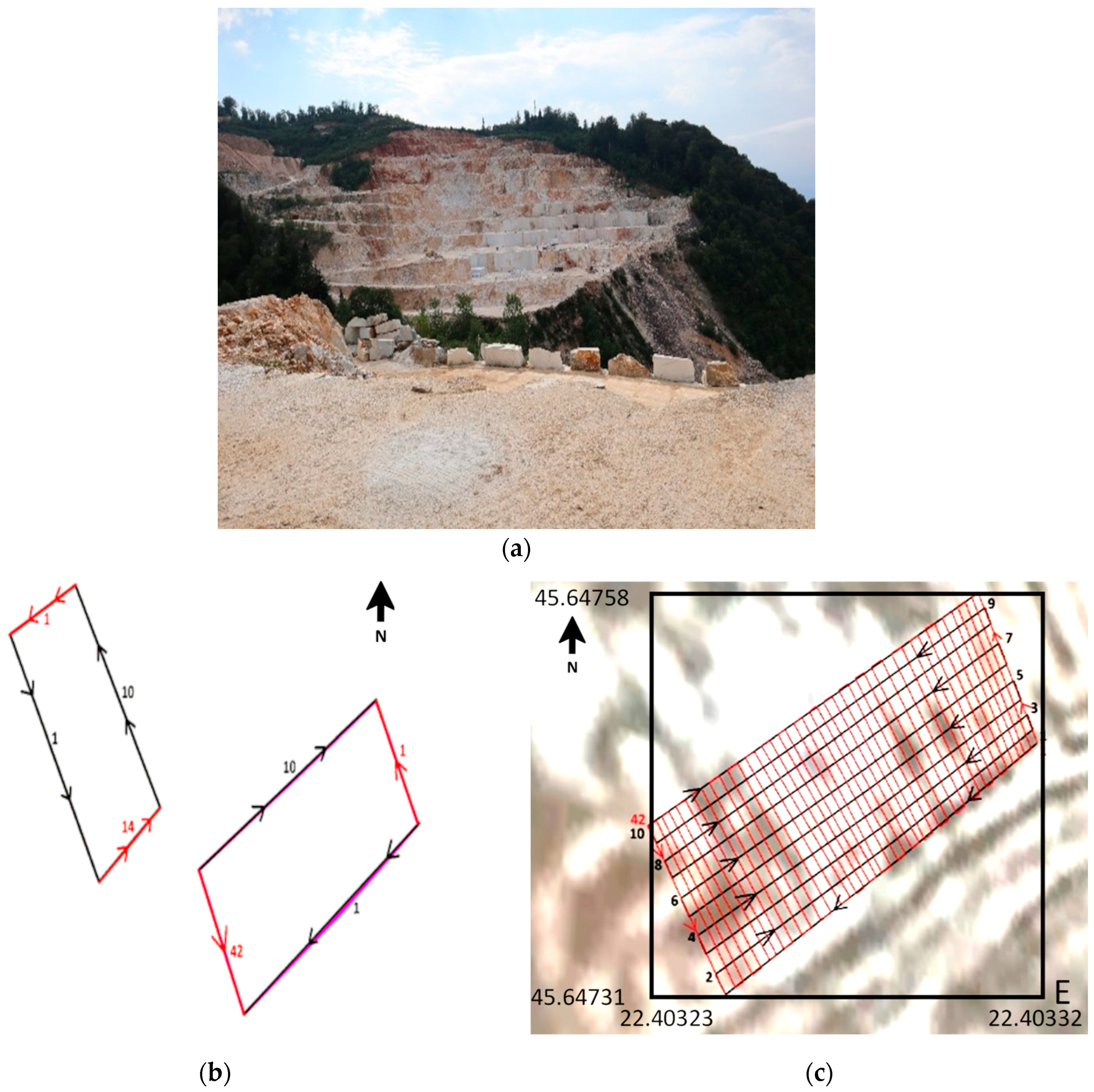
4.1. Italy’s GPR Measure
4.2. Grids Description
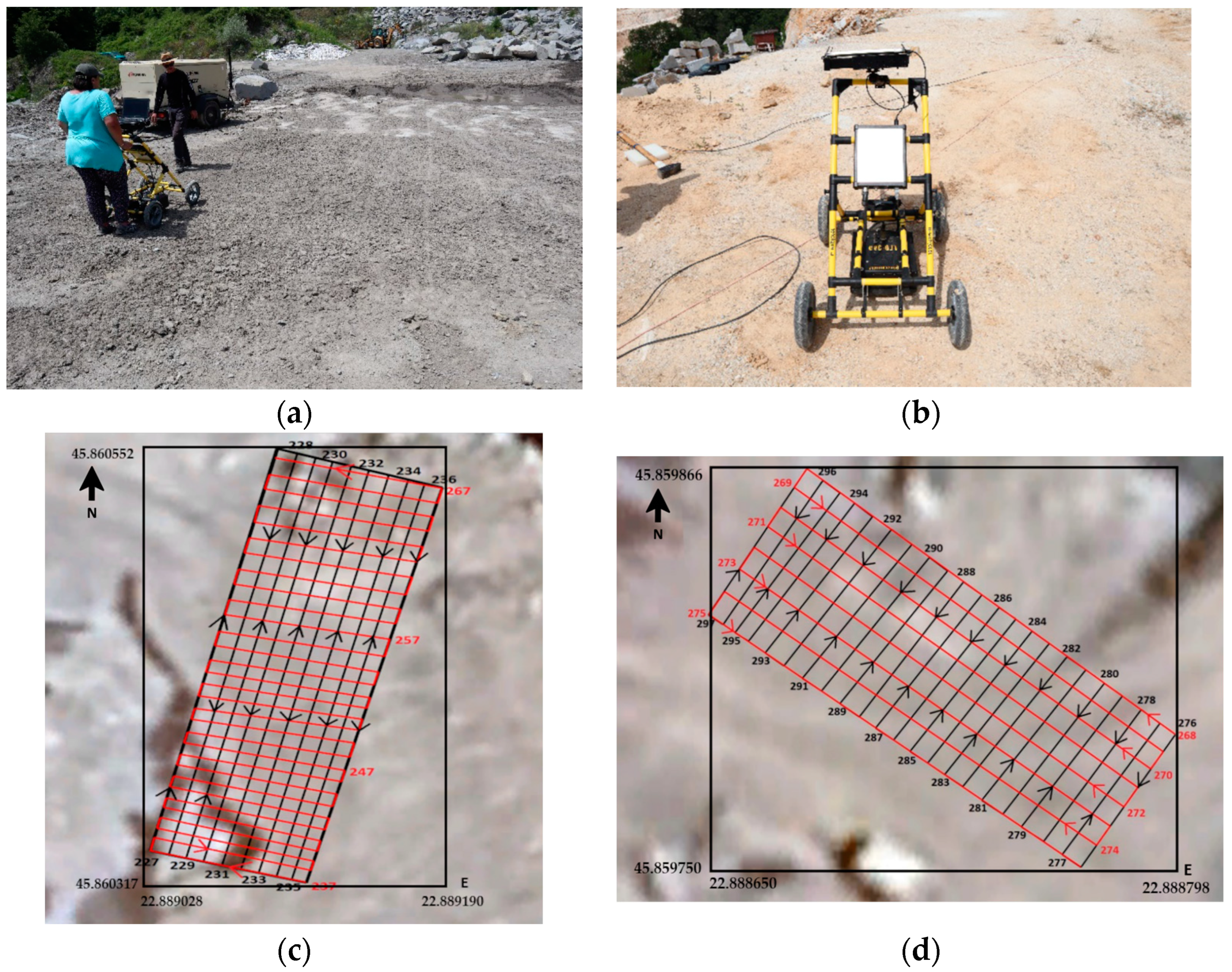
4.3. Romania GPR Measure
4.3.1. Ruschita Quarry
4.3.2. Carpinis Quarry
4.3.3. Pietroasa Quarry
5. Data Examples
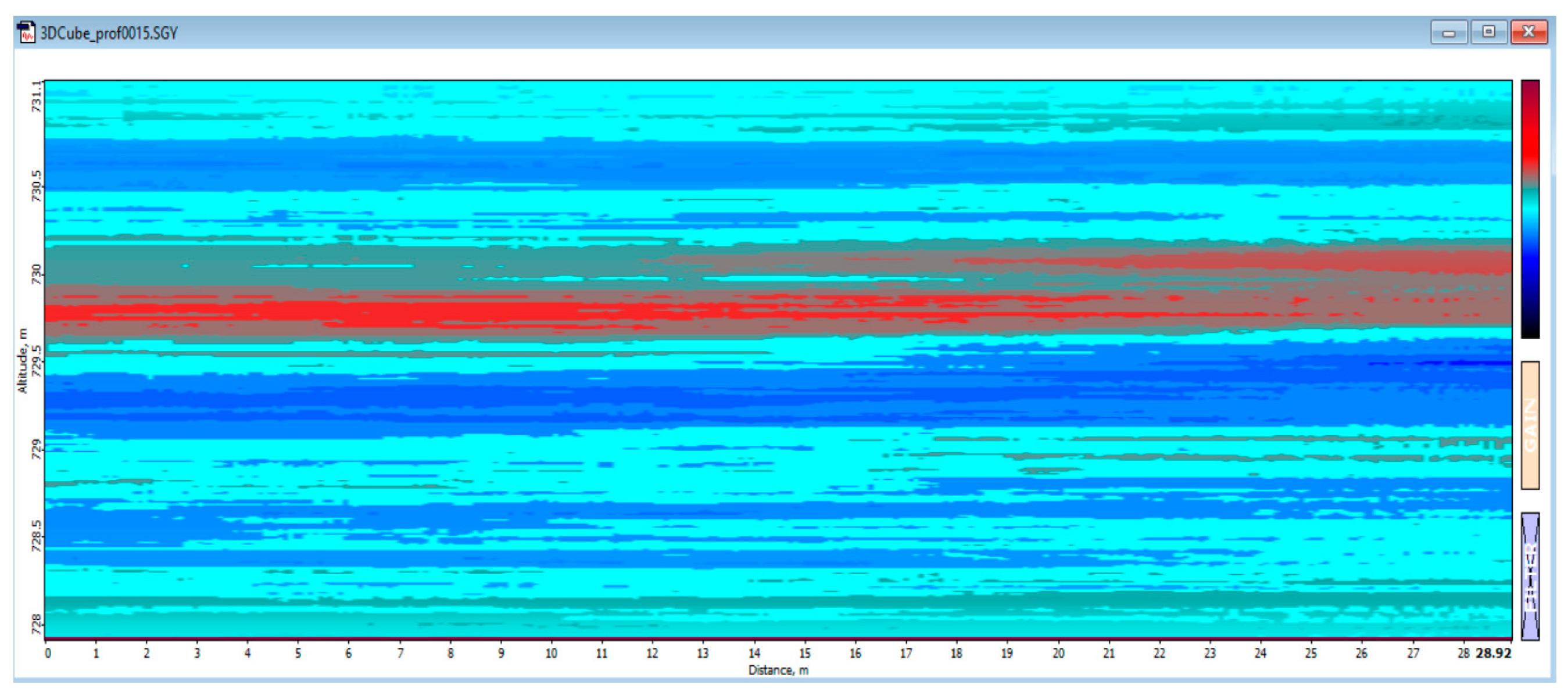
5.1. Italy’s GPR Data Example
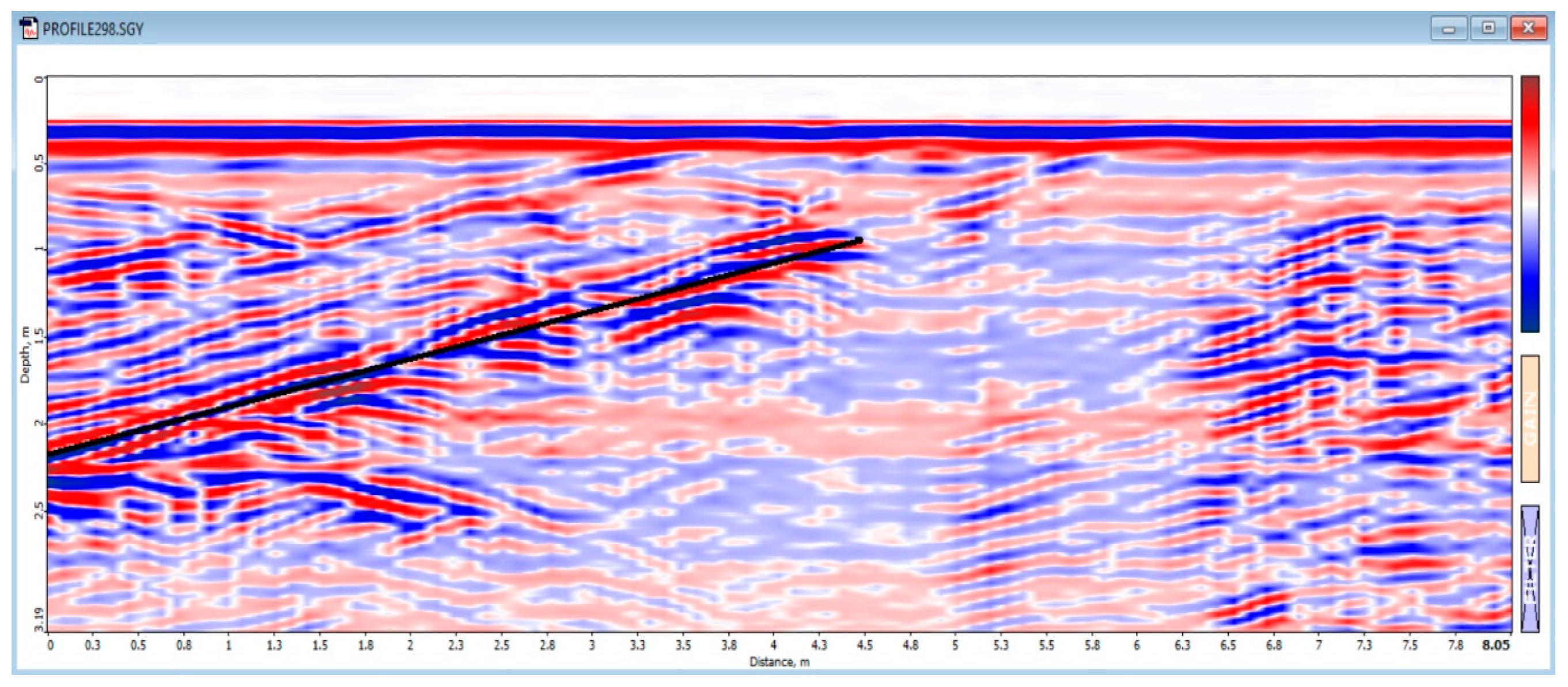
5.2. Romania’s GPR Data Example
6. User Notes
Author Contributions
Funding
Institutional Review Board Statement
Informed Consent Statement
Data Availability Statement
Conflicts of Interest
References
- Theune, U.; Rokosh, D.; Sacchi, M.D.; Schmitt, D.R. Mapping fractures with GPR: A case study from Turtle Mountain. Geophysics 2006, 71, B139–B150. [Google Scholar] [CrossRef][Green Version]
- Dérobert, X.; Abraham, O. GPR and seismic imaging in a gypsum quarry. J. Appl. Geophys. 2000, 45, 157–169. [Google Scholar] [CrossRef]
- Seol, S.J.; Kim, J.H.; Song, Y.; Chung, S.H. Finding the strike direction of fractures using GPR. Geophys. Prospect. 2001, 49, 300–308. [Google Scholar] [CrossRef]
- Arosio, D. Rock fracture characterization with GPR by means of deterministic deconvolution. J. Appl. Geophys. 2016, 126, 27–34. [Google Scholar] [CrossRef]
- Toshioka, T.; Tsuchida, T.; Sasahara, K. Application of GPR to detecting and mapping cracks in rock slopes. J. Appl. Geophys. 1995, 33, 119–124. [Google Scholar] [CrossRef]
- Rey, J.; Martínez, J.; Montiel, V.; Cañadas, F.; Ruiz, N. Characterization of the sedimentary fabrics in ornamental rocks by using GPR. Near Surf. Geophys. 2017, 15, 457–465. [Google Scholar] [CrossRef]
- Grandjean, G.; Gourry, J.C. GPR data processing for 3D fracture mapping in a marble quarry (Thassos, Greece). J. Appl. Geophys. 1996, 36, 19–30. [Google Scholar] [CrossRef]
- Zanzi, L.; Hojat, A.; Ranjbar, H.; Karimi-Nasab, S.; Azadi, A.; Arosio, D. GPR measurements to detect major discontinuities at Cheshmeh-Shirdoosh limestone quarry, Iran. Bull. Eng. Geol. Environ. 2017, 78, 743–752. [Google Scholar] [CrossRef]
- Lualdi, M.; Zanzi, L. 2D and 3D experiments to explore the potential benefit of GPR investigations in planning the mining activity of a limestone quarry. In Proceedings of the Tenth International Conference Ground Penetrating Radar, Delft, The Netherlands, 21–24 June 2004. [Google Scholar]
- Elkarmoty, M.; Colla, C.; Gabrielli, E.; Bonduà, S.; Bruno, R. A Combination of GPR Survey and Laboratory Rock Tests for Evaluating an Ornamental Stone Deposit in a Quarry Bench. Procedia Eng. 2017, 191, 999–1007. [Google Scholar] [CrossRef]
- Porsani, J.L.; Sauck, W.A.; Júnior, A.O.S. GPR for mapping fractures and as a guide for the extraction of ornamental granite from a quarry: A case study from southern Brazil. J. Appl. Geophys. 2006, 58, 177–187. [Google Scholar] [CrossRef]
- Elkarmoty, M.; Bonduà, S.; Bruno, R. A 3D optimization algorithm for sustainable cutting of slabs from ornamental stone blocks. Resour. Policy 2020, 65, 101533. [Google Scholar] [CrossRef]
- Şirin, E.; Bonduà, S.; Elkarmoty, M. Environmental and economic optimization for block cutting of dimension stones in a limestone quarry. Resour. Policy 2021, 74, 102396. [Google Scholar] [CrossRef]
- Arriba, M.F.; Díaz-Fernández, M.E.; González-Nicieza, C.; Álvarez-Fernández, M.I.; Álvarez-Vigil, A.E. A computational algorithm for rock cutting optimisation from primary blocks. Comput. Geotech. 2013, 50, 29–40. [Google Scholar] [CrossRef]
- Ülker, E.; Turanboy, A. Maximum volume cuboids for arbitrarily shaped in-situ rock blocks as determined by discontinuity analysis—A genetic algorithm approach. Comput. Geosci. 2009, 35, 1470–1480. [Google Scholar] [CrossRef]
- Turanboy, A. A geometric approach for natural rock blocks in engineering structures. Comput. Geosci. 2010, 14, 565–577. [Google Scholar] [CrossRef]
- Turanboy, A.; Ülker, E. LIP-RM: An attempt at 3D visualization of in situ rock mass structures. Comput. Geosci. 2008, 12, 181–192. [Google Scholar] [CrossRef]
- Ghozzi, R.; Lahouar, S.; Besbes, K.; Souani, C. Mapping of sewer lines using GPR: A case study in Tunisia. Data 2018, 3, 40. [Google Scholar] [CrossRef]
- Zhang, J.-X.; Zhang, N.; Xu, Y.-S. Data on point cloud scanning and ground radar of composite lining in jointly constructed tunnel. Data Brief 2022, 41, 107993. [Google Scholar] [CrossRef] [PubMed]
- Oualid, M. Electric resistivity data sets for Geohazards subsurface characterization in Guerrara area, southwestern Algeria. Data Brief 2018. [CrossRef]
- Campana, S.; Piro, S. Seeing the Unseen: Geophysics and Landscape Archaeology; CRC Press: Leiden, The Netherlands, 2009; ISBN 978-0-415-44721-8. [Google Scholar]
- Conyers, L.B. Ground-Penetrating Radar for Geoarchaeology; Wiley-Blackwell Publishers: London, UK, 2016. [Google Scholar]
- Conyers, L.B. Medieval Site in Ireland. In Ground-Penetrating Radar and Magnetometry for Buried Landscape Analysis; Springer Briefs in Geography; Springer International Publishing: Cham, Switzerlands, 2018; pp. 75–90. ISBN 978-3-319-70890-4. [Google Scholar] [CrossRef]
- Gaffney, V.; Patterson, H.; Piro, S.; Goodman, D.; Nishimura, Y. Multimethodological approach to study and characterise Forum Novum (Vescovio Central Italy). Archaeol. Prospect. 2004, 11, 201–212. [Google Scholar] [CrossRef]
- Goodman, D.; Piro, S. Ground penetrating radar (GPR) surveys at Aiali (Grosseto). In Seeing the Un-Seen. Geophysics and Landscape Archaeology; Campana, S., Piro, S., Eds.; Taylor and Francis: London, UK, 2009; pp. 297–302. ISBN 978-0-415-44721-8. [Google Scholar]
- Piro, S.; Goodman, D.; Nishimura, Y. The study and characterization of Emperor Traiano’s villa using high-resolution integrated geophysical surveys. Archaeol. Prospect. 2003, 10, 1–25. [Google Scholar] [CrossRef]
- Radar System Inc. Prism 2 (Version 2.7x) User’s Manual—Riga, LV-1012, Latvia. 2022. Available online: www.radsys.lv (accessed on 1 September 2023).


| Site | Number of Scan Lines | Scan Section (m × m) |
|---|---|---|
| Grid 1 | 8 × 14 | 3.5 × 6.5 |
| Grid 2 | 10 × 7 | 4.5 × 3.5 |
| Grid 3 | 7 × 10 | 3.5 × 5.5 |
Disclaimer/Publisher’s Note: The statements, opinions and data contained in all publications are solely those of the individual author(s) and contributor(s) and not of MDPI and/or the editor(s). MDPI and/or the editor(s) disclaim responsibility for any injury to people or property resulting from any ideas, methods, instructions or products referred to in the content. |
© 2024 by the authors. Licensee MDPI, Basel, Switzerland. This article is an open access article distributed under the terms and conditions of the Creative Commons Attribution (CC BY) license (https://creativecommons.org/licenses/by/4.0/).
Share and Cite
Bonduà, S.; Monteiro Klen, A.; Pilone, M.; Asimopolos, L.; Asimopolos, N.-S. A Set of Ground Penetrating Radar Measures from Quarries. Data 2024, 9, 42. https://doi.org/10.3390/data9030042
Bonduà S, Monteiro Klen A, Pilone M, Asimopolos L, Asimopolos N-S. A Set of Ground Penetrating Radar Measures from Quarries. Data. 2024; 9(3):42. https://doi.org/10.3390/data9030042
Chicago/Turabian StyleBonduà, Stefano, André Monteiro Klen, Massimiliano Pilone, Laurentiu Asimopolos, and Natalia-Silvia Asimopolos. 2024. "A Set of Ground Penetrating Radar Measures from Quarries" Data 9, no. 3: 42. https://doi.org/10.3390/data9030042
APA StyleBonduà, S., Monteiro Klen, A., Pilone, M., Asimopolos, L., & Asimopolos, N.-S. (2024). A Set of Ground Penetrating Radar Measures from Quarries. Data, 9(3), 42. https://doi.org/10.3390/data9030042