Data Descriptor

High-Resolution UAV RGB Imagery Dataset for Precision Agriculture and 3D Photogrammetric Reconstruction Captured over a Pistachio Orchard (Pistacia vera L.) in Spain

1
Information Technology Group, Wageningen University and Research, 6708 PB Wageningen, The Netherlands
2
Instituto Tecnológico Agrario de Castilla y León (ITACyL), Unidad de Cultivos Leñosos y Hortícolas, 47071 Valladolid, Spain
*
Author to whom correspondence should be addressed.
Data 2022, 7(11), 157; https://doi.org/10.3390/data7110157
Submission received: 23 October 2022 / Revised: 6 November 2022 / Accepted: 8 November 2022 / Published: 10 November 2022

Abstract

:
A total of 248 UAV RGB images were taken in the summer of 2021 over a representative pistachio orchard in Spain (X: 341450.3, Y: 4589731.8; ETRS89/UTM zone 30N). It is a 2.03 ha plot, planted in 2016 with Pistacia vera L. cv. Kerman grafted on UCB rootstock, with a NE–SW orientation and a 7 × 6 m triangular planting pattern. The ground was kept free of any weeds that could affect image processing. The photos (provided in JPG format) were taken using a UAV DJI Phantom Advance quadcopter in two flight missions: one planned to take nadir images (β = 0°), and another to take oblique images (β = 30°), both at 55 metres above the ground. The aerial platform incorporates a DJI FC6310 RGB camera with a 20 megapixel sensor, a horizontal field of view of 84° and a mechanical shutter. In addition, GCPs (ground control points) were collected. Finally, a high-quality 3D photogrammetric reconstruction process was carried out to generate a 3D point cloud (provided in LAS, LAZ, OBJ and PLY formats), a DEM (digital elevation model) and an orthomosaic (both in TIF format). The interest in using remote sensing in precision agriculture is growing, but the availability of reliable, ready-to-work, downloadable datasets is limited. Therefore, this dataset could be useful for precision agriculture researchers interested in photogrammetric reconstruction who want to evaluate models for orthomosaic and 3D point cloud generation from UAV missions with changing flight parameters, such as camera angle.
Dataset License: CC-BY 4.0.

1. Summary

The size of the canopy in woody crops, such as pistachio, significantly impacts the quantity, quality, and load of crops [1]. However, canopy/crown monitoring takes a lot of time and labour because technicians usually measure tree dimensions in the field.
Precision agriculture, or precision farming, is an agricultural management concept based on monitoring, measuring and responding to the inter- and intra-plot variability of the crop [2]. In this sense, precision agriculture enables the localised application of treatments and tillage, even splitting the same plot into various zones. This is a definite advantage over traditional management, which employs uniform operations, allowing fertiliser and pesticide application to be carried out only where and when necessary [3,4]. However, precision farming is a concept that relies on tools to make it happen. Therefore, on a practical level, their chances of success are directly related to the successful application of the various technologies employed. In this way, remote sensing methods are an excellent tool to obtain information quickly, objectively, and non-destructively [5].
Remote sensing is a tool that encompasses a series of techniques and procedures that make it possible to analyse crops through different approaches. The ones based on photogrammetry are one of the most widely used due to their remarkable results [6]. By using these methods, a scene or object can be precisely reconstructed from a series of images with enough overlap. In order to create 3D models, photogrammetric algorithms such as structure from motion can process 2D data and determine the geometric relationships between the photos and the objects [7].
Several platforms can be employed in remote sensing, such as satellites or UAVs. However, satellite images frequently have a low spatial resolution, which leads to issues due to pixel size, so depending on the application, it is often not the ideal choice [7,8]. Therefore, for applications such as photogrammetry that demand high-precision imagery, UAV platforms are increasingly being used because they allow high-resolution data to be obtained because aerial drones can fly at low altitudes [9]. Moreover, oblique photography presents some advantages for reconstructing 3D point clouds. Therefore, aerial photography is increasingly used in precision agriculture at oblique angles [10], such as the images in the present dataset.
The development of solutions based on remote sensing is a promising area in which considerable progress has been made. It is interesting to note the increased investment in technological innovation in agriculture compared to other sectors in traditional woody crop-producing countries, such as Spain [11]. Furthermore, there is growing interest in the scientific and research field of precision agriculture [12]. However, technicians and researchers require high-precision datasets to develop studies leading to the creation of the remote sensing-based tools mentioned. In precision agriculture, a great collection of photographs is necessary to obtain reliable data for the entire field under investigation. This data must be acquired following a precise workflow, with sufficient technical knowledge to acquire the ground truth points (GCPs), develop an adequate flight mission, take the images with the required overlapping, accuracy and sharpness for additional picture analysis and the creation of 3D digital models of the crops.
The dataset presented in this work aims to provide reliable and accurate UAV RGB images for precision agriculture, specifically for photogrammetric reconstruction in woody crops. For this purpose, two flights with varying camera angles were performed to collect RGB images of pistachio trees aiming to study the effect of capturing the trees from various angles on the generation of accurate 3D point clouds for digital reconstructions of the pistachio orchard and orthomosaics for their use in precision agriculture, such as tree counting, or the extraction of parameters of agronomic significance such as leaf area, canopy volume or other phenotyping traits.

2. Data Description

The dataset is composed of nine zip files (Table 1). Two zip files contain the original JPEG images, one for each flight. In addition, a photogrammetric process was performed, and the generated point cloud was exported in four commonly used formats for 3D reconstruction: LAS, LAZ, OBJ and PLY. Additionally, the DEM and orthomosaic are provided in TIF format to show the dataset’s potential and enable researchers to start quickly. Finally, a CSV file including all GCPs is included, allowing for the possibility of high precision georeferencing.

Original Data-UAV RGB Images and GCPs

Two sets of images are included. The RGB images have the following characteristics:
  • Bands: RGB
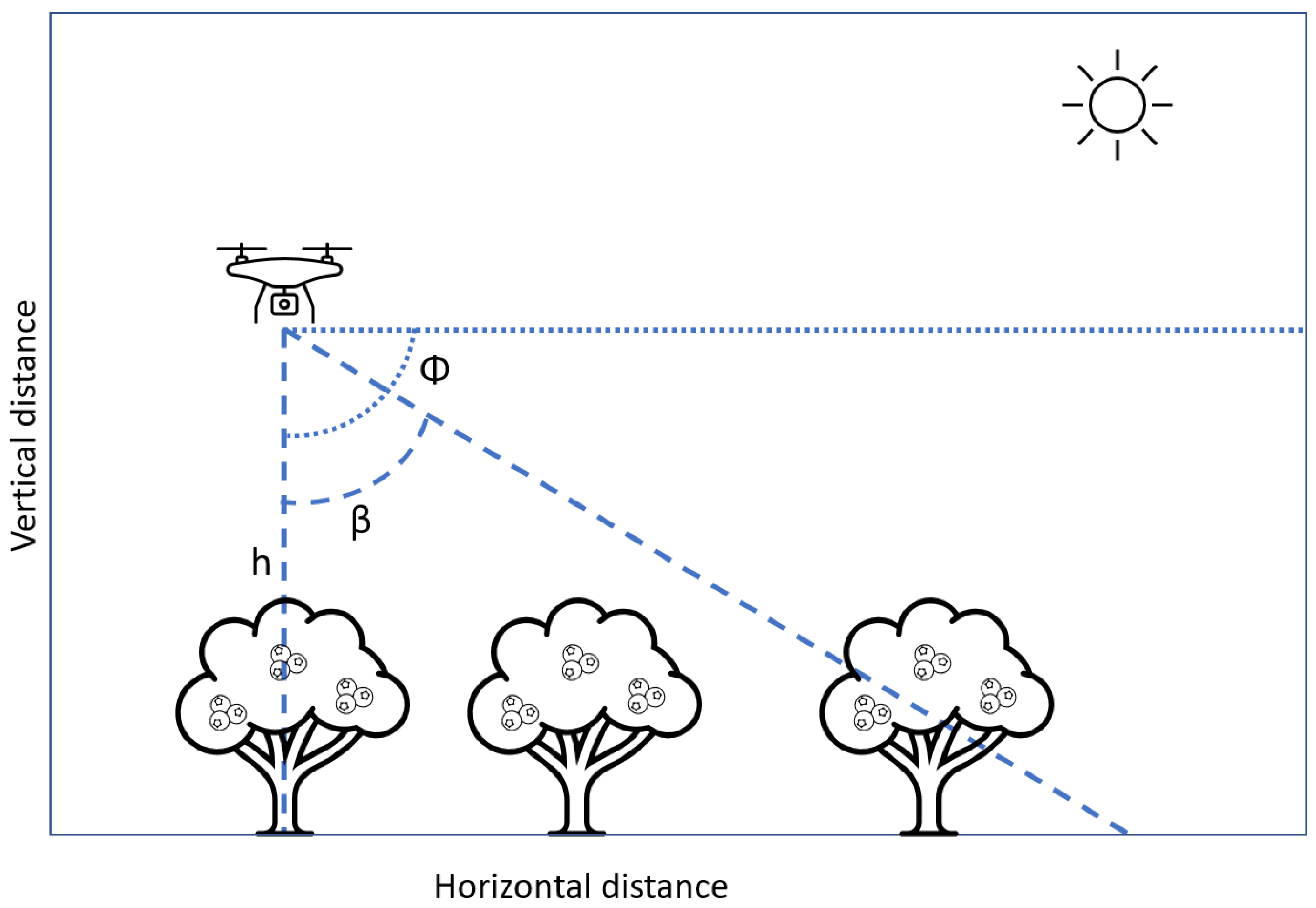
  • Flight height: 55 m above ground level
  • Longitudinal and cross overlap: 80%
  • Resolution: 20 megapixels
  • Image size: 5475 px × 3078 px
All photos are geotagged in EXIF format, capturing the data in a Lat/Long coordinate system (WGS84). The names of the pictures are as they were recorded by the drone, with the following structure: “DJI_imageNumber.JPG”. The image number is a correlative number assigned by the drone.
There is one main difference between the two sets of images: in the first flight (images_nadir_RGB.zip), the images were captured with a nadir angle (β = 0°), whereas in the second flight (images_oblique_RGB.zip), the images were captured using β = 30°. As a result, the trees were photographed from different perspectives (Figure 1). The photos (Figure 2) were taken under adequate light conditions, without clouds (0 okta).
Regarding the high-precision georeferencing, GCPs were located in the field and georeferenced using a high-accuracy GPS to enhance the geometric accuracy of the image mosaicking process, optimise camera positions and improve the orientation of the data. The CSV file contains four columns with the id of each GCP and the X, Y, and Z coordinates. The GCPs have the following characteristics:
  • Number of control points: 5
  • Coordinate reference system: ETRS89/UTM zone 30 N
  • Accuracy of control points in the project: X error (cm): 2.2808; Y error (cm): 2.01787; Z error (cm): 0.284695; Total (cm): 3.05857; Image (pix): 2.090

3. Methods

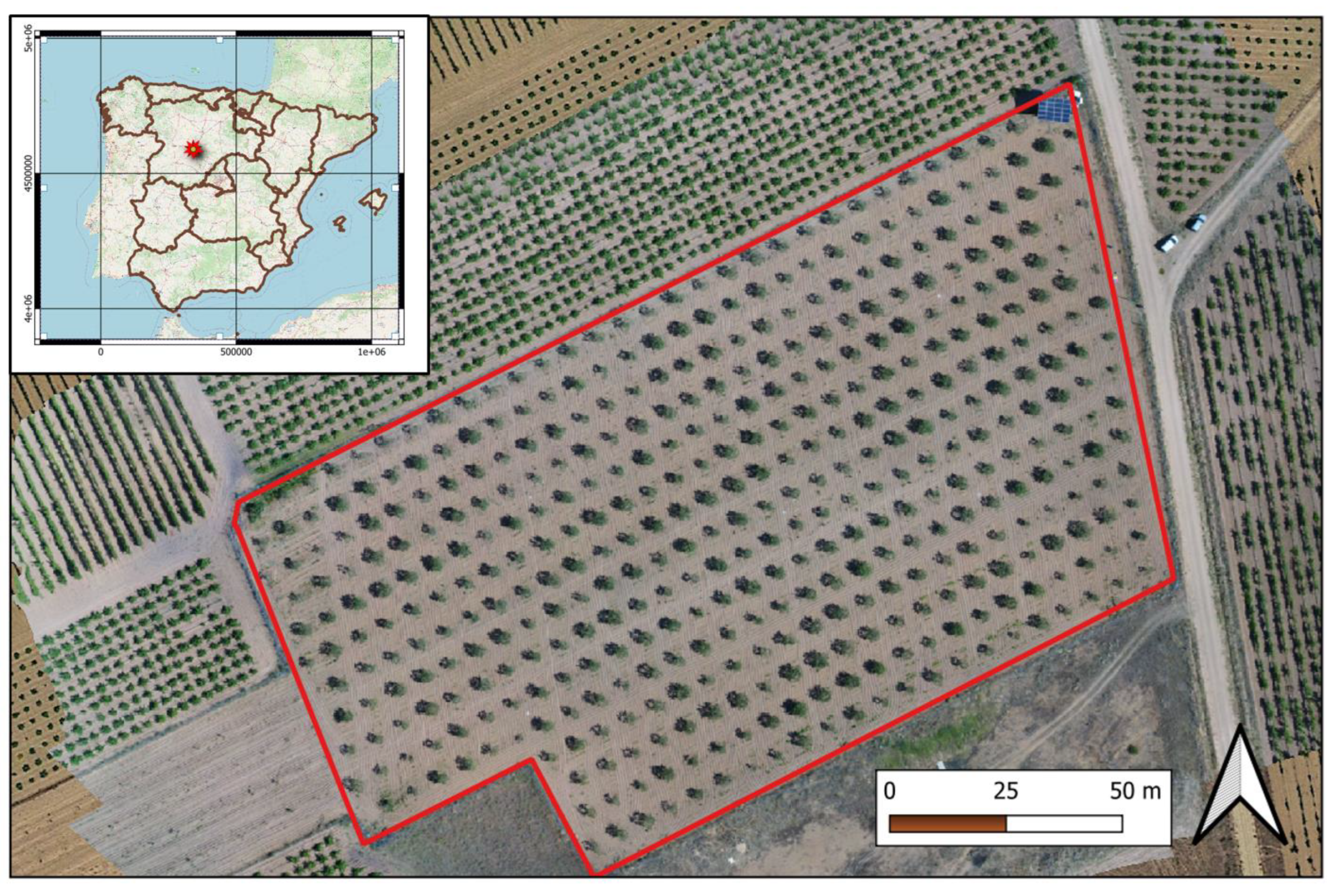
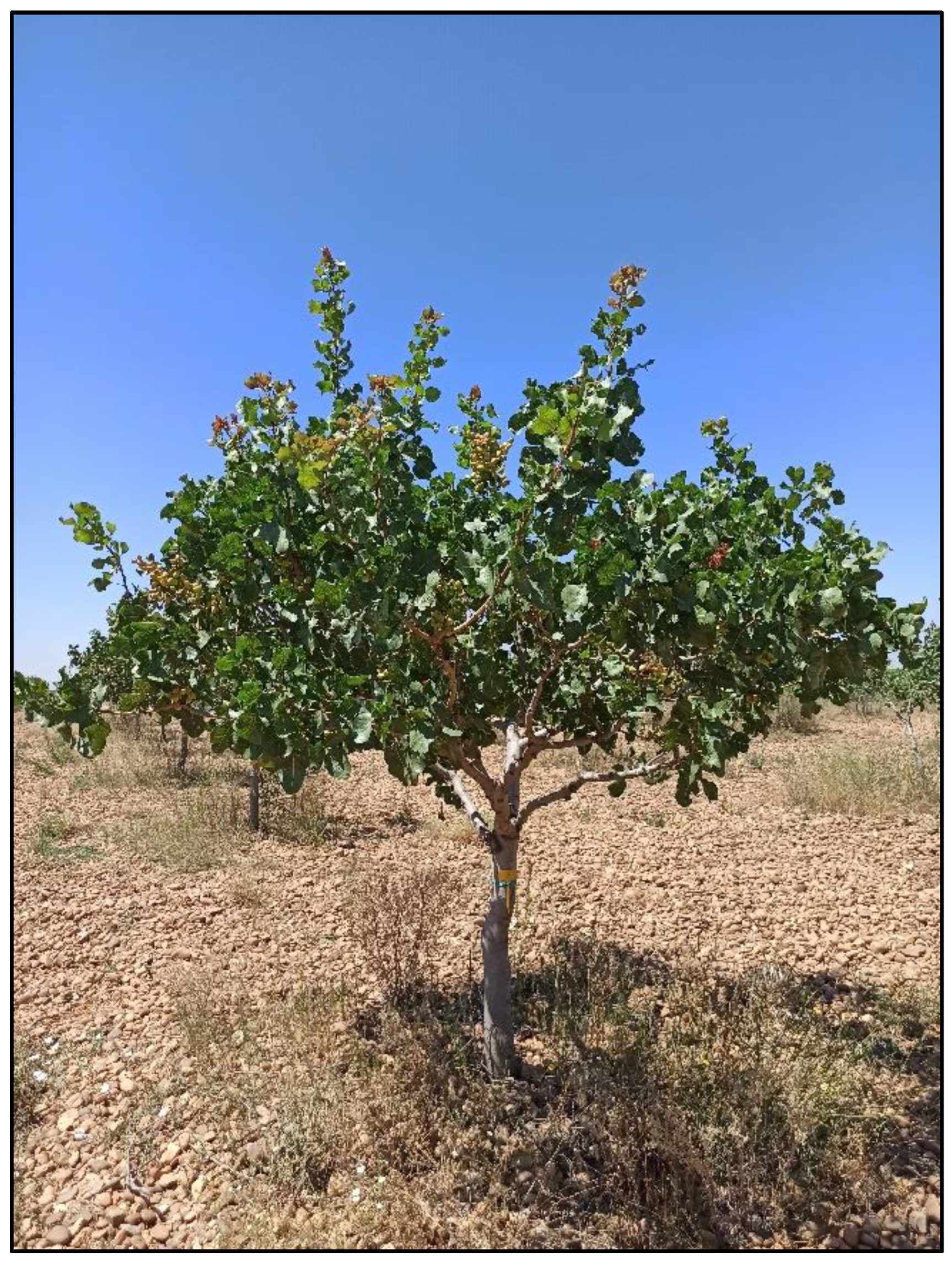
3.1. Experimental Site

The pistachio orchard is a 2.03 ha plot located in “La Seca”, Valladolid, within the region of Castilla y León, Spain (X: 341450.3, Y: 4589731.8; ETRS89/UTM zone 30N; Figure 3). It was planted in 2016 using Pistacia vera L. cv. Kerman grafted on UCB rootstock, with a NE–SW orientation and a 7 × 6 m triangular planting pattern.
Figure 4 presents a ground-level photo showing the pistachio tree when the UAV images were taken. Regulatory pruning was carried out to manage vegetation growth while leaving the entire quantity of flower buds. In addition, the ground was kept free of any weeds that could affect image processing. However, some isolated weeds are present under the pistachio tree canopies as they are hard to eliminate.

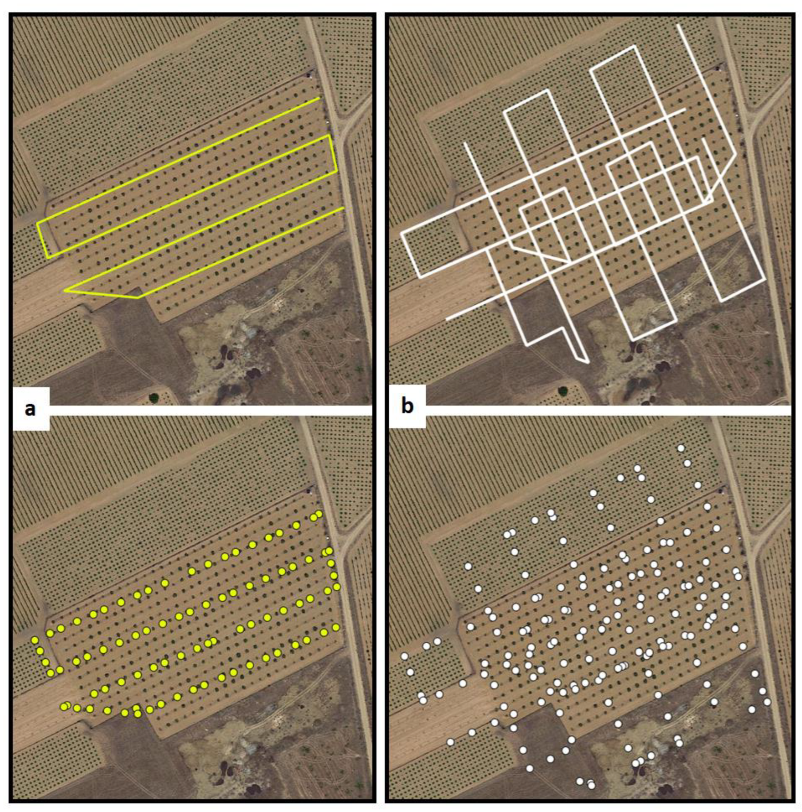
3.2. Ground Control Points (GCPs)
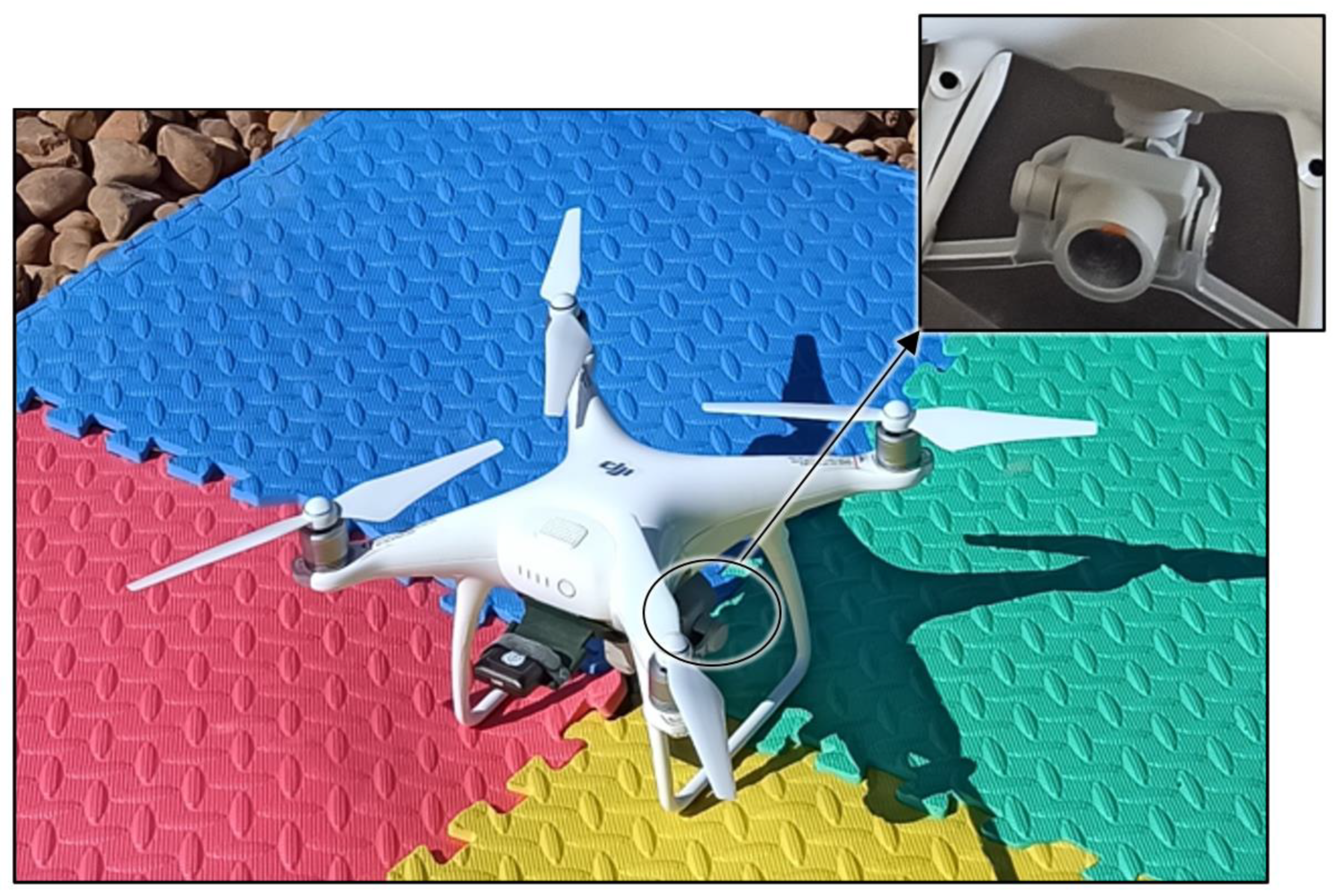
Five GCPs were established in the field and georeferenced using a real-time kinematic (RTK) GNSS Antenna Triumph-2 JAVAD to improve the orientation of the data, optimise camera positions, and increase the geometric accuracy of the image mosaicking process. The system provides a very high position accuracy (Horizontal: 0.010 m + 1 ppm, Vertical: 0.015 m + 1 ppm).

3.3. UAV Platform

The aerial survey was performed using a UAV DJI Phantom Advance quadcopter (DJI Sciences and Technologies Ltd., Shenzhen, Guangdong, China) equipped with a DJI FC6310 RGB camera (Figure 5). It is a 35 cm length aerial platform with advanced characteristics such as obstacle detection (0.7–30 m range) and satellite positioning using GPS and GLONASS. According to the information provided by the manufacturer [13], the UAV has a max horizontal speed of 72 kph, with a max tilt angle of 42°, and a max vertical Speed of 6 m/s and 4 m/s while ascending and descending, respectively. In addition, the max wind speed resistance is 10 m/s, and the max service ceiling above sea level is 19,685 feet (6000 m).
The drone employs 15.2 V LiPo 4S intelligent flight batteries, with a capacity of 5870 mAh and a weight of 468 g, leading to a UAV total weight of 1368 g, including battery and propellers. The batteries allow a max flight time of 30 min, approximately, with operating temperature ranges from 0° to 40 °C.
The camera is mounted on a gimbal capable of 3-axis (pitch, roll, yaw) stabilisation, with a controllable range pitch angle (Φ) from −90° to +30°. The camera is a 1-inch 20-megapixel CMOS sensor with an aperture from F2.8 to F11, a focal length of 8.8 mm (35 mm equivalent: 24 mm), an ISO range from 100–3200 (Auto) to 100–12,800 (Manual), horizontal field of view of 84° and mechanical shutter for rolling shutter distortion reduction. The max image size is 5472 × 3648, allowing 3:2, 4:3 and 16:9 aspect ratios.
The camera has several shooting modes, including “Single Shot” and “Burst”, and it can record video from 1280 × 720 120 p at 60 Mbps video bitrate to 4096 × 2160 60 p at 100 Mbps video bitrate. It supports FAT32 (≤32 GB) and exFAT (>32 GB) file systems, videos in MP4/MOV (AVC/H.264; HEVC/H.265) file formats and photos in JPEG, DNG (RAW), JPEG + DNG file formats. It requires a micro SD card up to 128 GB, with at least a write speed ≥15 MB/s Class 10 or UHS-1 rating.
It is essential to follow the manufacturer’s requirements regarding storage since a low-speed micro SD could lead to data losses or incorrectly captured information. Therefore, aiming to ensure good quality data, we employed a Class 10 128 GB micro SDXC SanDisk Extreme, with UHS Speed Class 3 (U3) and read and write speeds of up to 190 MB/s and 130 MB/s, respectively [14].

3.4. UAV Mission Description

The aerial surveys were performed on 29 July 2021 over a pistachio field, capturing 248 images. The solar noon in the location of the pistachio orchard was at 14:26 (local time).
The flights were performed around 11:20 AM (local time), with an average sun elevation angle of 45° and an azimuth angle of 106°. Therefore, the shadows of the plants are clearly visible on the ground. The main difference between the two flights is that in the first one, the camera captured the images with a −90° gimbal pitch degree (Φ), therefore using β = 0° (nadir), whereas, during the second flight, the images were captured with a Φ = −60°, consequently using β = 30° (Figure 1). In this way, the flight mapping surveys were designed using DJI Pilot App (v1.9.0), setting up the UAV horizontal speed at 4 m/s and a flying height of 55 m above ground level (AGL), resulting in a theoretical average ground sample distance (GSD) of 1.53 cm/px. The side and frontal overlap ratios were 80%. In both flights, the camera was set up using “Single shot” mode within “photography mode”. The quality of the images was selected to the highest quality (5475 px × 3078 px), and ISO was configured manually at 400 and a 7.1 aperture. All photos were geotagged automatically by the DJI FC6310 RGB camera in EXIF format, capturing the data in a Lat/Long coordinate system (WGS84).
The flight for the nadir images was conducted in straight lines. In contrast, the flight for the oblique photos was performed in a double grid pattern, flying in orthogonal directions. Figure 6 shows the flight paths planned for each mission and the positions at which the camera finally took the images during the flight.

4. Usage Example: 3D Photogrammetric Reconstruction

Although the primary intention of the dataset is to deliver trustworthy and precise UAV RGB images for precision agriculture, particularly for woody crops, a high-quality 3D photogrammetric reconstruction is proposed to show the usability of the data. In addition, the products resulting from the photogrammetric process were also uploaded to the online repository with the original images.

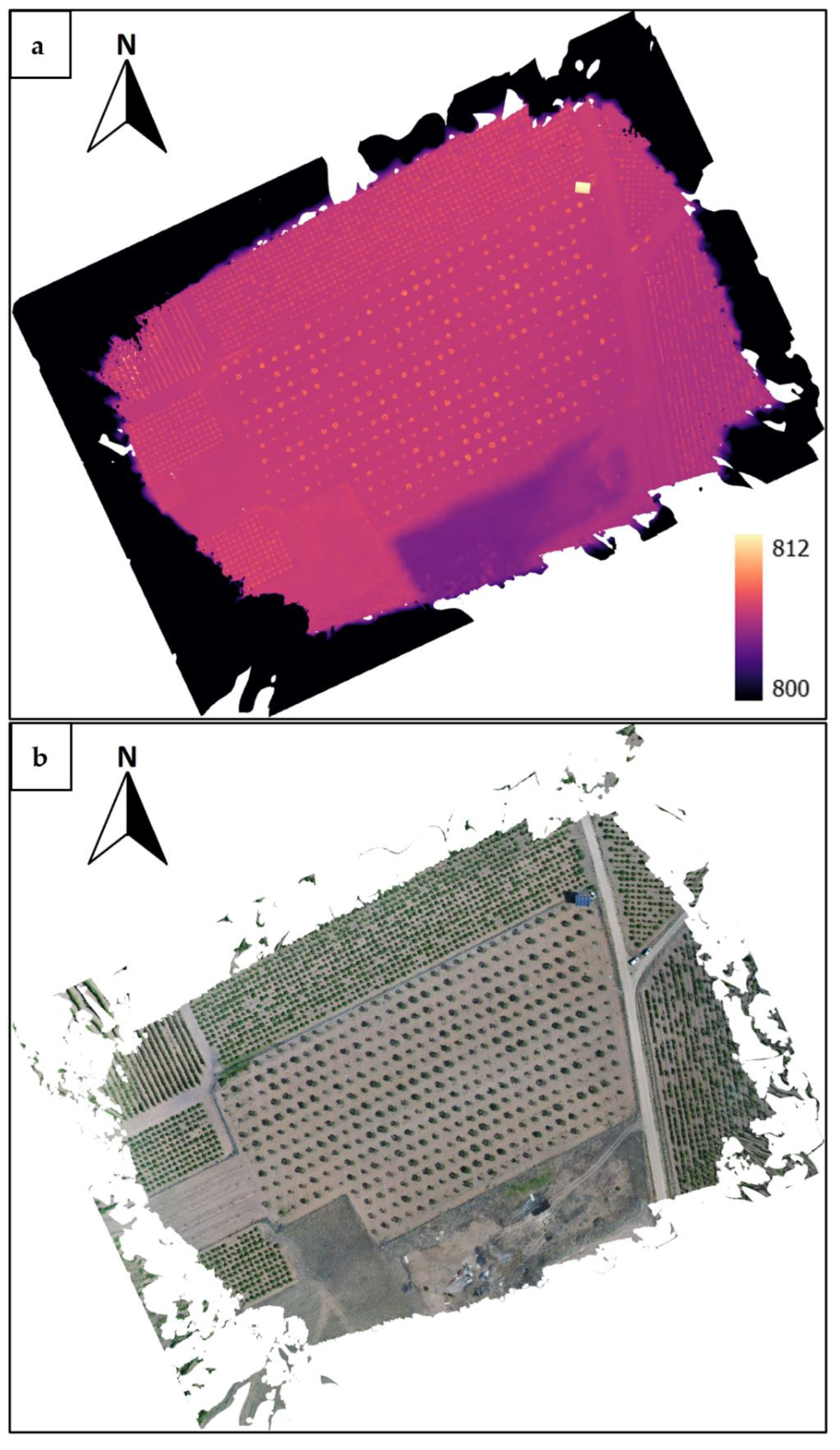
4.1. Image Processing 3D Point Cloud, DEM and Orthomosaic

A high-quality photogrammetric reconstruction process was performed using all images, generating a 3D point cloud, DEM and orthomosaic, enabling researchers to quickly visualise the potential of the data and provide them with ready-to-work products.
Agisoft Metashape Professional software, v1.7.6 (Agisoft LLC, St. Petersburg, Russia), was employed because it achieves remarkably good results in photogrammetric processes when 2D images are involved [15]. The workflow was performed according to the software provider guidelines. To this end, first, the photos were aligned, selecting the highest accuracy, 100,000 key points limit and 40,000 tie points limit. In this step, a camera optimisation process was performed, the coordinates of the GCPs were loaded, and each one was located in at least three different images to improve product accuracy. Then, the dense cloud was generated, with ultra-high quality and disabled depth filtering, calculating point colours. Finally, the DEM (digital elevation model) was created with the highest quality, and the orthomosaic was generated. All other options were set to default.
A high-performance computing platform with Windows 10 was employed to develop the photogrammetric process. It was equipped with an AMD Ryzen 9 5900X processor with 12 cores, a base frequency of 3.7 GHz and 4.8 GHz in turbo mode, 128GB DDR4 3200 MHz CL16 in four modules, and one TB SSD M.2 NVMe PCIe Gen3 x4. In addition, the computer was accompanied by an Nvidia RTX 3060 graphics card with a 1777 Mhz core clock, 15,000 Mhz memory clock, 3584 CUDA cores and 12 GB GDDR6. The complete photogrammetric process took 13:30 h.

4.2. Generated Data

A high-quality point cloud (Figure 7), a DEM and an orthomosaic (Figure 8) are provided, with the following characteristics:
  • 3D point cloud:
Number of points: 268,979,477
Coordinate reference system: ETRS89/UTM zone 30 N
  • DEM:
Resolution: 1.59 cm/pix
Coordinate reference system: ETRS89/UTM zone 30 N
Minimum level: 745.1
Maximum level: 848.6
  • Orthomosaic:
Resolution: 1.59 cm/pix
Coordinate reference system: ETRS89/UTM zone 30 N
The point cloud contains six columns with the X, Y, and Z positions and R, G, and B values. The DEM has one channel/band with the elevation information, and the orthomosaic includes four channels per file: R, G, B and Alpha, for transparency.

5. Potential Research Applications

As mentioned, there is growing interest in using remote sensing in precision agriculture. However, the availability of reliable and ready-to-work UAV datasets available to download is limited. Therefore, this dataset could be helpful for precision agriculture researchers who want to evaluate models for orthomosaic and 3D point cloud generation from UAV missions with varying flight parameters, such as different camera angles. Moreover, it could be useful for:
  • Testing or developing algorithms for tree crown isolation and tree counting on an OBIA [16,17] or a pixel-based analysis [18].
  • Extracting parameters of agronomic significance such as leaf area, canopy volume, height or other phenotyping traits [19].
  • Analysing vegetation indices based on RGB bands. Although the camera is RGB and therefore does not have as accurate radiometric calibration as other types of cameras, such as multispectral cameras, some researchers suggest that RGB cameras can be used to generate vegetation indices [20,21].
  • Segmenting the image and studying the effect of ground shadows on the image and their relationship with its agronomic and biophysical parameters [22].
  • Testing algorithms or workflows for real-time applications [23].
  • Data fusion or combination with freely available open-access satellite images, such as Sentinel or Landsat imagery [24].

Author Contributions

Conceptualisation: S.V.; data curation: S.V. and R.V.; formal analysis: S.V.; investigation: S.V.; methodology: S.V., S.Á. and R.V.; project administration: S.Á; resources: S.V., H.M., D.R.-R., R.V. and S.Á.; software: S.V. and R.V.; supervision: S.V.; visualisation: S.V. and R.V.; writing—original draft: S.V.; writing—review and editing: S.Á. and R.V.; funding acquisition: S.Á. All authors have read and agreed to the published version of the manuscript.

Funding

The work was generated within the project IDI-20200822, granted by the CDTI (Centre for Industrial Technological Development of Spain) and FEADER funds to develop and improve pistachio cultivation in the region.

Data Availability Statement

The dataset presented in this study is openly available at https://zenodo.org/record/7271542#.Y2ZE03bMJhE (accessed on 9 November 2022) with https://doi.org/10.5281/zenodo.7271542 (accessed on 9 November 2022).

Conflicts of Interest

The authors declare no conflict of interest.

Ethics Statements

The authors declare that the present work did not include experiments on human subjects or animals.

References

  1. Ferguson, L.; Polito, V.; Kallsen, C. The Pistachio Tree; Botany and Physiology and Factors That Affect Yield. In Pistachio Production Manual; University of California: Davis, CA, USA, 2005; pp. 31–39. [Google Scholar]
  2. Zarco-Tejada, P.; Hubbard, N.; Loudjani, P. Precision Agriculture: An Opportunity for EU Farmers-Potential Support with the CAP 2014–2020; Joint Research Centre (JRC) of the European Commission. Monitoring Agriculture ResourceS (MARS) Unit H04: Brussels, Belgium, 2014; Volume 56. [Google Scholar]
  3. Bongiovanni, R.; Lowenberg-Deboer, J. Precision Agriculture and Sustainability. Precis. Agric. 2004, 5, 359–387. [Google Scholar] [CrossRef]
  4. Ammoniaci, M.; Kartsiotis, S.-P.; Perria, R.; Storchi, P. State of the Art of Monitoring Technologies and Data Processing for Precision Viticulture. Agriculture 2021, 11, 201. [Google Scholar] [CrossRef]
  5. Krishna, K.R. Push Button Agriculture: Robotics, Drones, Satellite-Guided Soil and Crop Management; AAP, Apple Academic Press: Oakville, ON, Canada, 2016; ISBN 978-1-77188-305-4. [Google Scholar]
  6. Nex, F.; Remondino, F. UAV for 3D Mapping Applications: A Review. Appl. Geomat. 2014, 6, 1–15. [Google Scholar] [CrossRef]
  7. Tsouros, D.C.; Bibi, S.; Sarigiannidis, P.G. A Review on UAV-Based Applications for Precision Agriculture. Information 2019, 10, 349. [Google Scholar] [CrossRef] [Green Version]
  8. Ozdogan, M.; Woodcock, C.E. Resolution Dependent Errors in Remote Sensing of Cultivated Areas. Remote Sens. Environ. 2006, 103, 203–217. [Google Scholar] [CrossRef]
  9. Colomina, I.; Molina, P. Unmanned Aerial Systems for Photogrammetry and Remote Sensing: A Review. ISPRS J. Photogramm. Remote Sens. 2014, 92, 79–97. [Google Scholar] [CrossRef] [Green Version]
  10. Li, M.; Shamshiri, R.R.; Schirrmann, M.; Weltzien, C.; Shafian, S.; Laursen, M.S. UAV Oblique Imagery with an Adaptive Micro-Terrain Model for Estimation of Leaf Area Index and Height of Maize Canopy from 3D Point Clouds. Remote Sens. 2022, 14, 585. [Google Scholar] [CrossRef]
  11. España en Cifras; Instituto Nacional de Estadística: Madrid, Spain, 2018.
  12. Santesteban, L.G. Precision Viticulture and Advanced Analytics. A Short Review. Food Chem. 2019, 279, 58–62. [Google Scholar] [CrossRef]
  13. DJI Phantom 4 Advanced Manual. Available online: https://www.dji.com/nl/downloads/products/phantom-4-adv (accessed on 20 October 2022).
  14. SanDisk Extreme® MicroSDXCTM UHS-I CARD Product Specifications. Available online: https://www.westerndigital.com/products/memory-cards/sandisk-extreme-uhs-i-microsd#SDSQXAA-128G-AN6MA (accessed on 20 October 2022).
  15. Elkhrachy, I. 3D Structure from 2D Dimensional Images Using Structure from Motion Algorithms. Sustainability 2022, 14, 5399. [Google Scholar] [CrossRef]
  16. de Castro, A.; Jiménez-Brenes, F.; Torres-Sánchez, J.; Peña, J.; Borra-Serrano, I.; López-Granados, F. 3-D Characterization of Vineyards Using a Novel UAV Imagery-Based OBIA Procedure for Precision Viticulture Applications. Remote Sens. 2018, 10, 584. [Google Scholar] [CrossRef]
  17. López-Granados, F.; Torres-Sánchez, J.; Jiménez-Brenes, F.M.; Arquero, O.; Lovera, M.; de Castro, A.I. An Efficient RGB-UAV-Based Platform for Field Almond Tree Phenotyping: 3-D Architecture and Flowering Traits. Plant Methods 2019, 15, 160. [Google Scholar] [CrossRef] [Green Version]
  18. Franklin, S.E. Pixel- and Object-Based Multispectral Classification of Forest Tree Species from Small Unmanned Aerial Vehicles. J. Unmanned Veh. Syst. 2018, 6, 195–211. [Google Scholar] [CrossRef] [Green Version]
  19. Nasiri, V.; Darvishsefat, A.A.; Arefi, H.; Pierrot-Deseilligny, M.; Namiranian, M.; Le Bris, A. Unmanned Aerial Vehicles (UAV)-Based Canopy Height Modeling under Leaf-on and Leaf-off Conditions for Determining Tree Height and Crown Diameter (Case Study: Hyrcanian Mixed Forest). Can. J. For. Res. 2021, 51, 962–971. [Google Scholar] [CrossRef]
  20. Yeom, J.; Jung, J.; Chang, A.; Ashapure, A.; Maeda, M.; Maeda, A.; Landivar, J. Comparison of Vegetation Indices Derived from UAV Data for Differentiation of Tillage Effects in Agriculture. Remote Sens. 2019, 11, 1548. [Google Scholar] [CrossRef] [Green Version]
  21. Feng, H.; Tao, H.; Li, Z.; Yang, G.; Zhao, C. Comparison of UAV RGB Imagery and Hyperspectral Remote-Sensing Data for Monitoring Winter Wheat Growth. Remote Sens. 2022, 14, 3811. [Google Scholar] [CrossRef]
  22. Vélez, S.; Poblete-Echeverría, C.; Rubio, J.A.; Vacas, R.; Barajas, E. Estimation of Leaf Area Index in Vineyards by Analysing Projected Shadows Using UAV Imagery. OENO One 2021, 55, 159–180. [Google Scholar] [CrossRef]
  23. Saddik, A.; Latif, R.; El Ouardi, A.; Alghamdi, M.; Elhoseny, M. Improving Sustainable Vegetation Indices Processing on Low-Cost Architectures. Sustainability 2022, 14, 2521. [Google Scholar] [CrossRef]
  24. Alvarez-Vanhard, E.; Corpetti, T.; Houet, T. UAV & Satellite Synergies for Optical Remote Sensing Applications: A Literature Review. Sci. Remote Sens. 2021, 3, 100019. [Google Scholar] [CrossRef]
Figure 1. Camera angles: h is the flight altitude, Φ is the gimbal pitch angle, and β is the angle from the nadir.
Data 07 00157 g001
Figure 2. Example of images included in the dataset, showing the same area. (a) Nadir image; (b) oblique image.
Data 07 00157 g002
Figure 3. Location of the pistachio orchard (Pistacia vera L. cv. Kerman grafted on UCB rootstock) in Valladolid, Castilla y León, Spain.
Data 07 00157 g003
Figure 4. State of development of the vegetation when the UAV images were taken.
Data 07 00157 g004
Figure 5. UAV DJI Phantom Advance quadcopter and detail of the DJI FC6310 RGB camera.
Data 07 00157 g005
Figure 6. Flight survey paths and camera positions for (a) nadir angle images and (b) oblique images.
Data 07 00157 g006
Figure 7. Three-dimensional point cloud generated in the photogrammetric process.
Data 07 00157 g007
Figure 8. (a) DEM, digital elevation model, and (b) orthomosaic as were generated in the photogrammetric process.
Data 07 00157 g008
Table 1. Description of the dataset, composed of nine zip files.
File NameFormatFilesSizeDescription
images_nadir_RGB.zipJPG86630.3 MBOriginal RGB images
images_oblique_RGB.zipJPG1621.2 GBOriginal RGB images
3DpointcloudLAS.zipLAS14 GBProcessed 3D dense cloud
3DpointcloudLAZ.zipLAZ13.6 GBProcessed 3D dense cloud
3DpointcloudOBJ.zipOBJ16.4 GBProcessed 3D dense cloud
3DpointcloudPLY.zipPLY14.6 GB Processed 3D dense cloud
DEM.zipTIF1987.8 MBDigital Elevation Model
orthomosaic.zipTIF1786.8 MBProcessed orthomosaic
GCPs.zipCSV1391 BytesGround Control Points
Publisher’s Note: MDPI stays neutral with regard to jurisdictional claims in published maps and institutional affiliations.

