National Open Data Cubes and Their Contribution to Country-Level Development Policies and Practices


 ,
, 

Abstract
:1. Introduction
2. Open Data Cube Examples
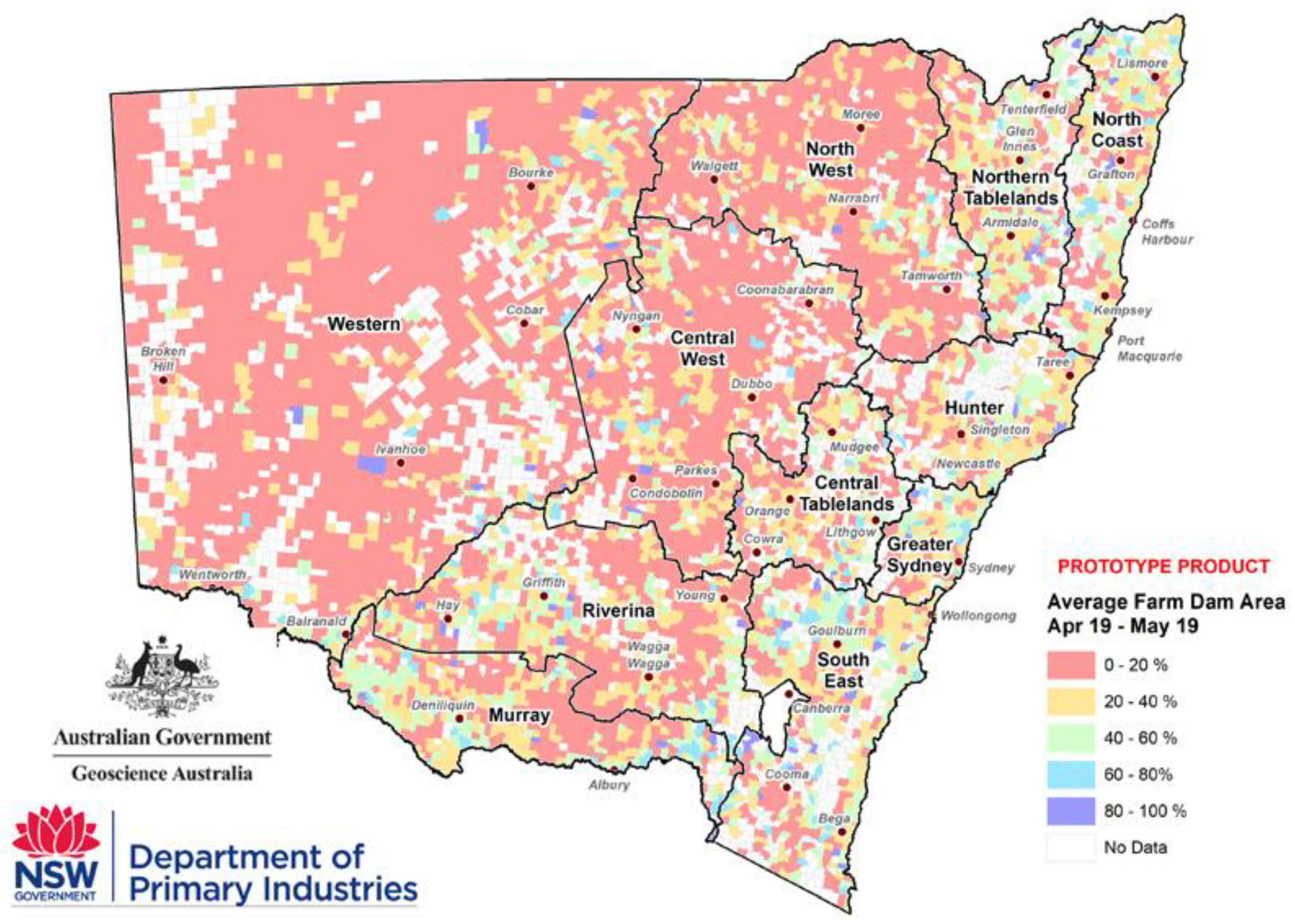
2.1. Water Resource Management in the Murray-Darling Basin, Australia
2.1.1. Overview of Digital Earth Australia
2.1.2. Managing Water in the Murray-Darling Basin, Australia
2.2. Snow Cover Monitoring, Switzerland
2.2.1. Overview of the Swiss Data Cube
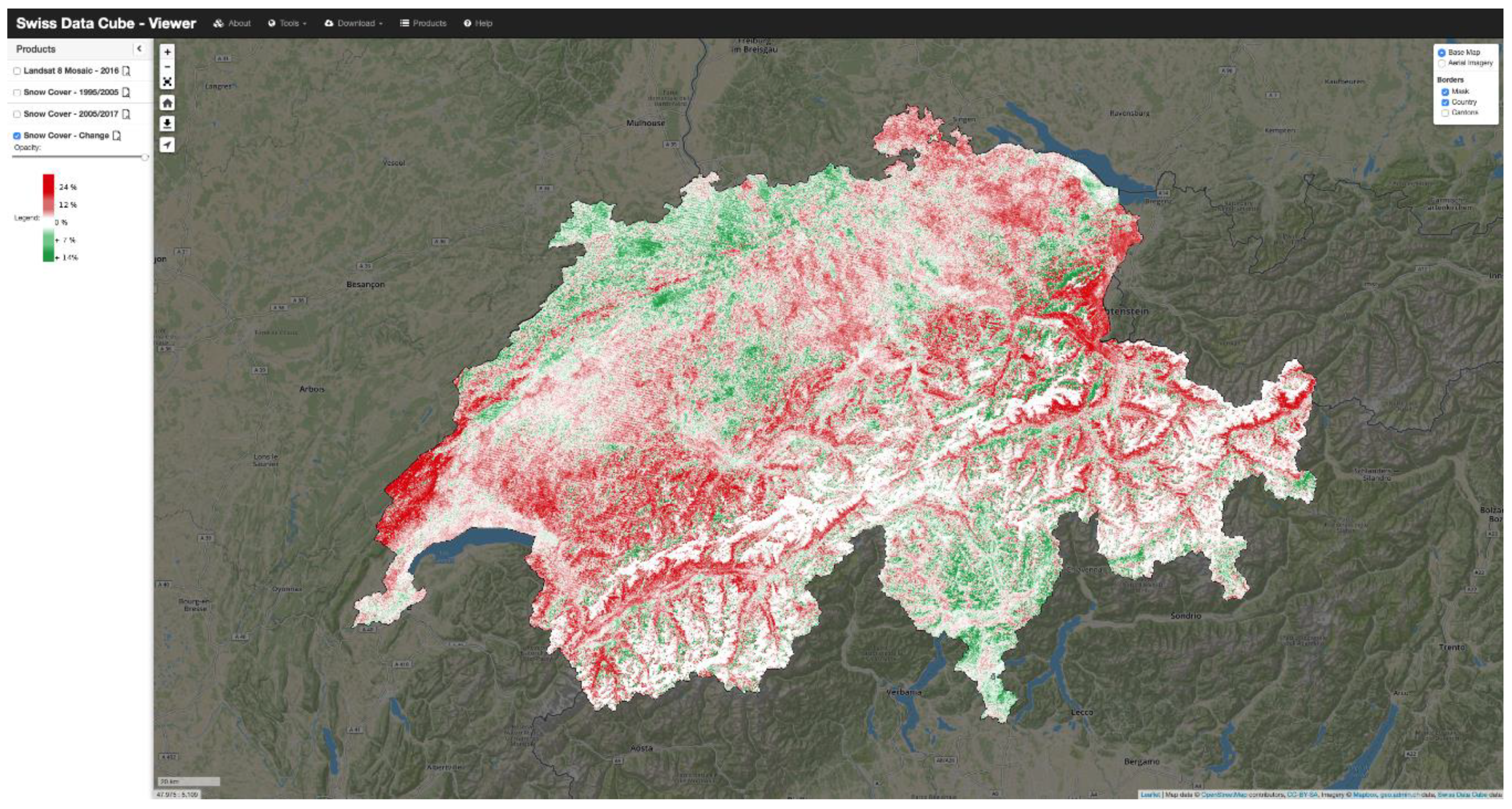
2.2.2. Monitoring Snow Cover Evolution, Switzerland
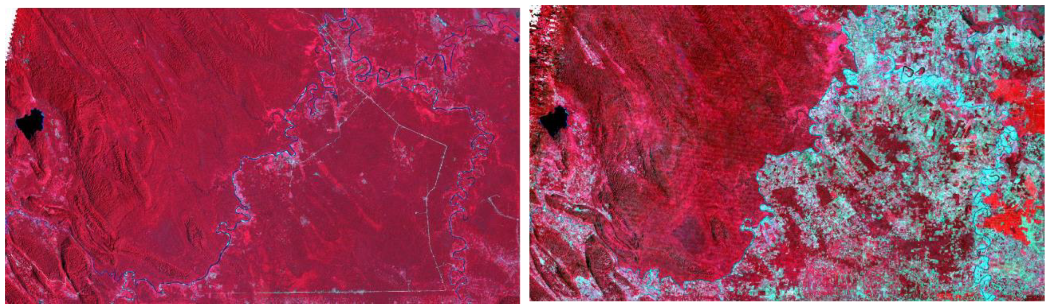
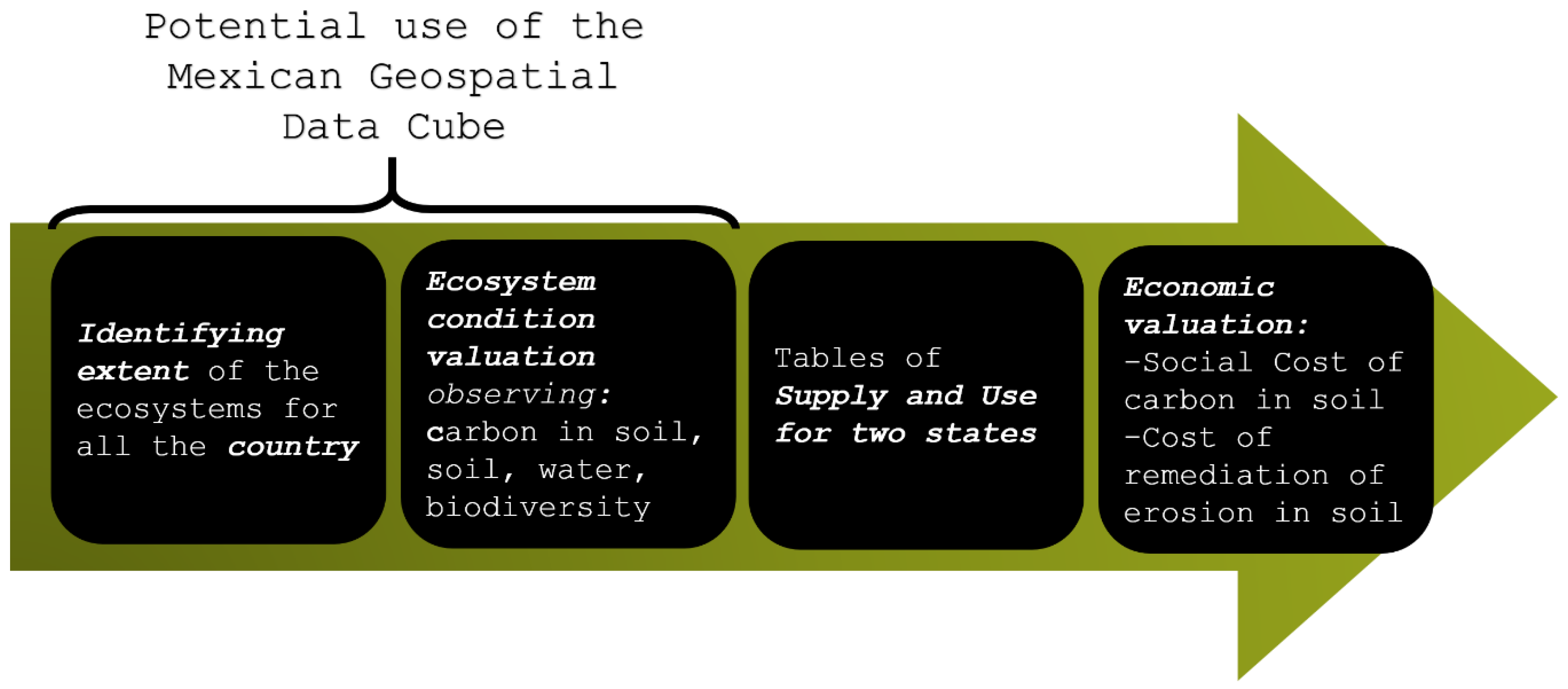
2.3. Testing the UN System for Economic-Environmental Accounting, Mexico
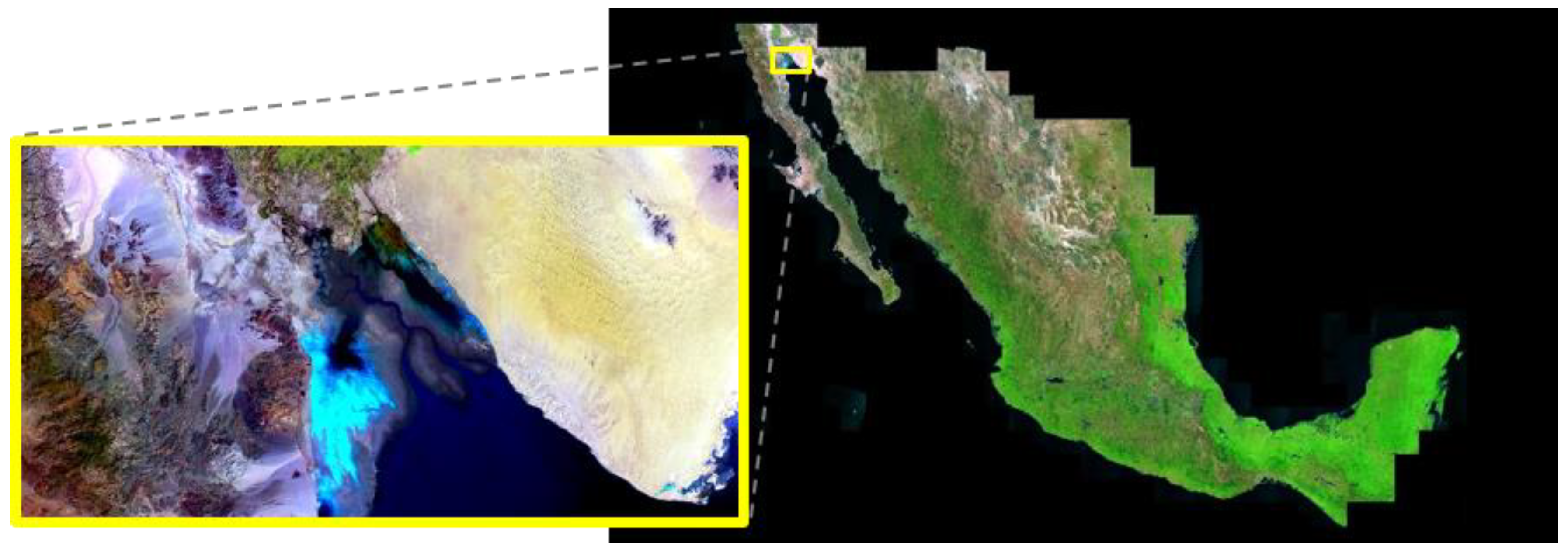
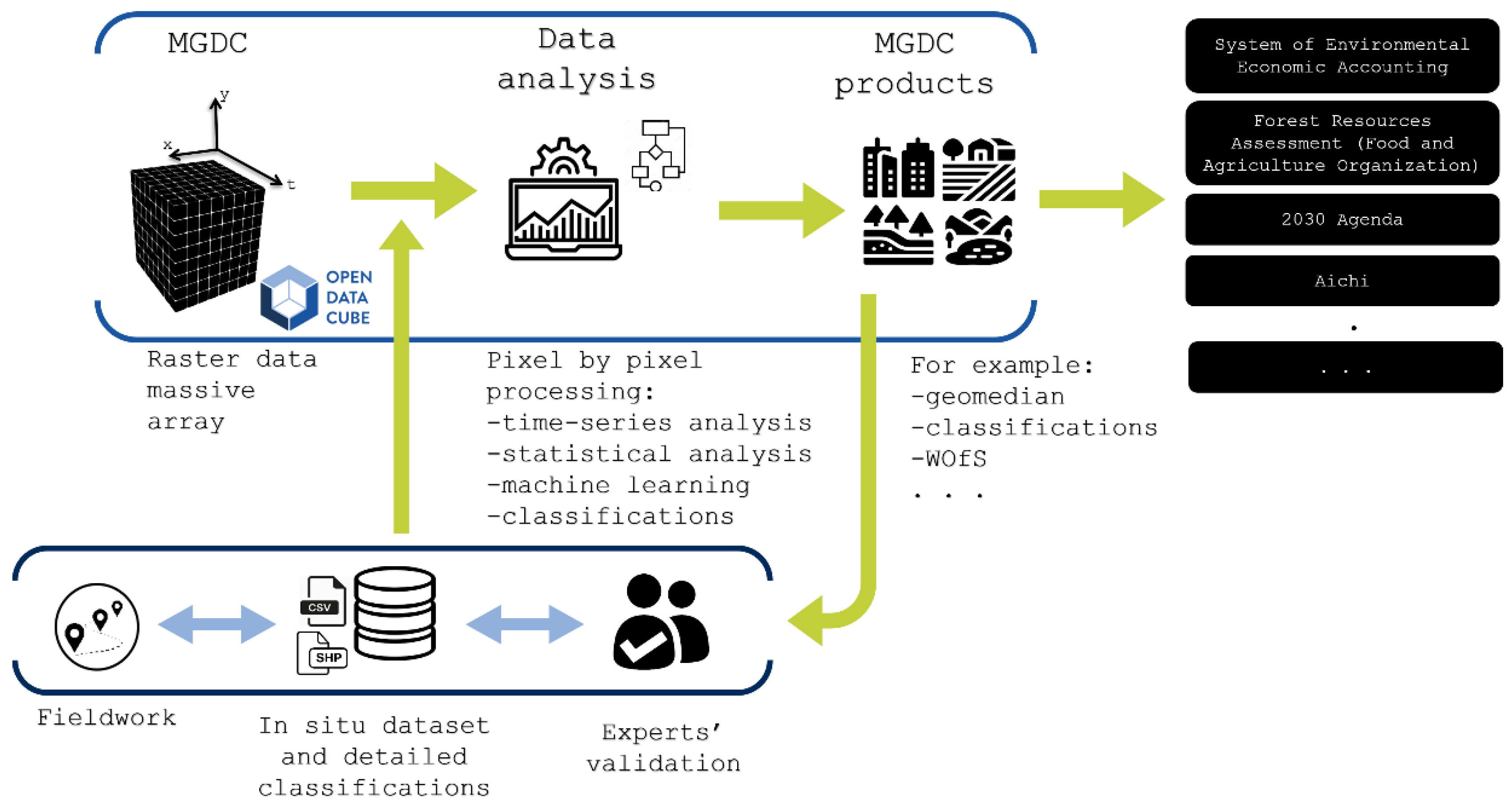
2.3.1. Overview of the Mexican Geospatial Data Cube
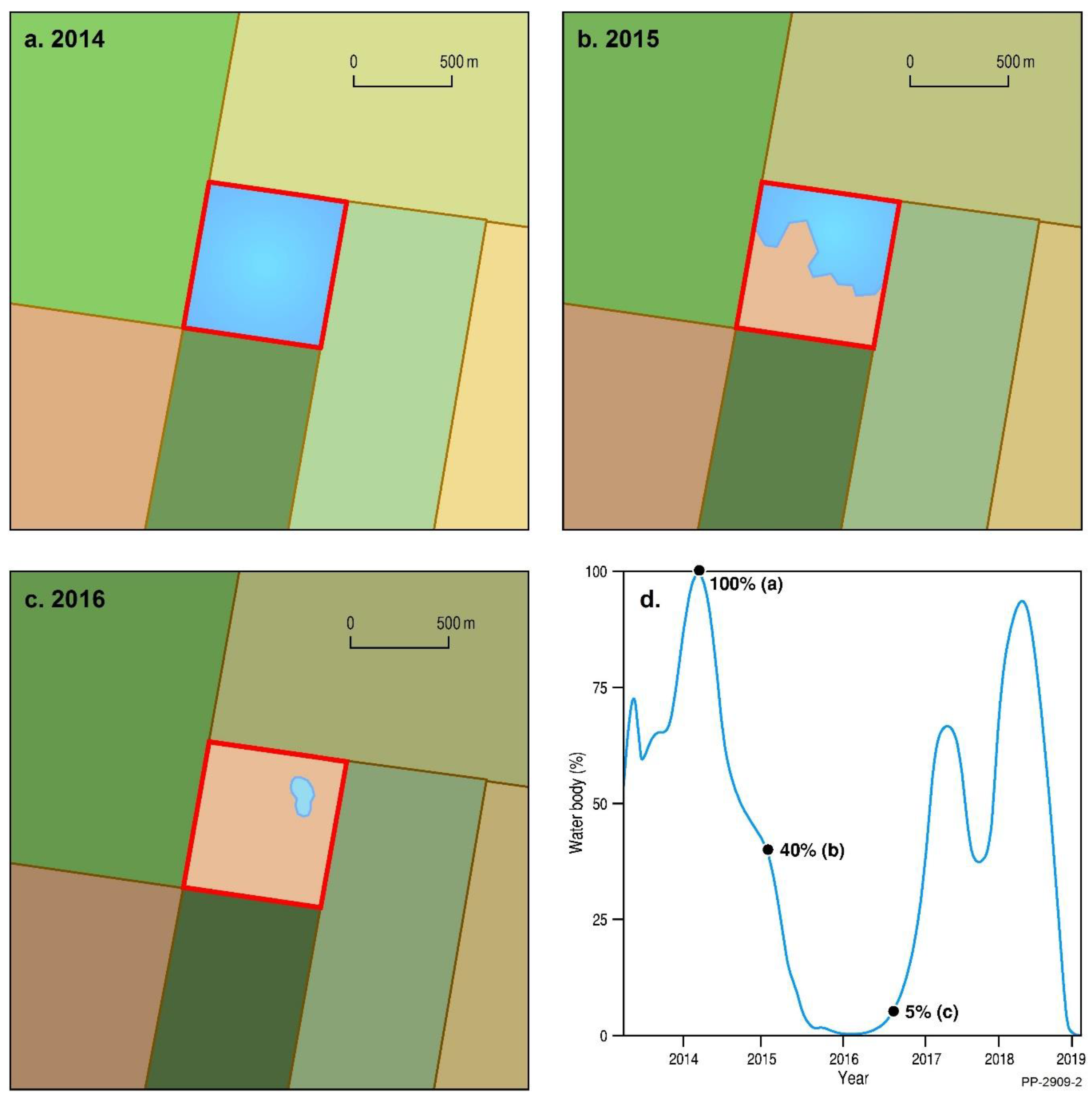
2.3.2. Using the MGDC for Natural Capital Accounting and Valuation of Ecosystem Services
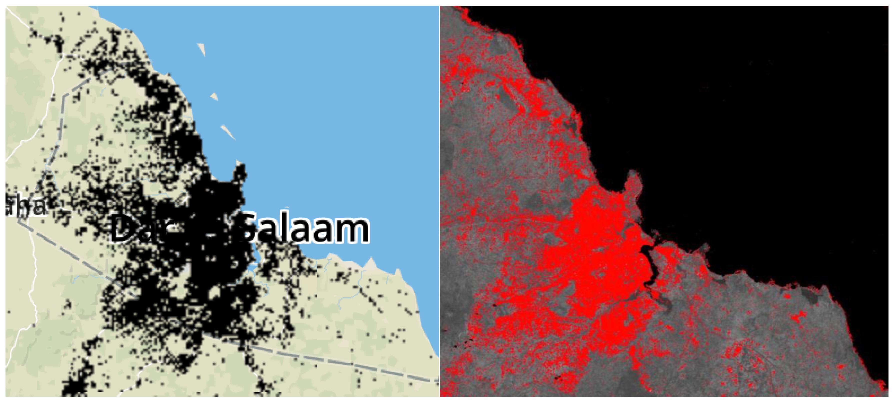
2.4. Using the African Regional Data Cube to Manage Urbanization in Tanzania
2.4.1. Overview of the African Regional Data Cube
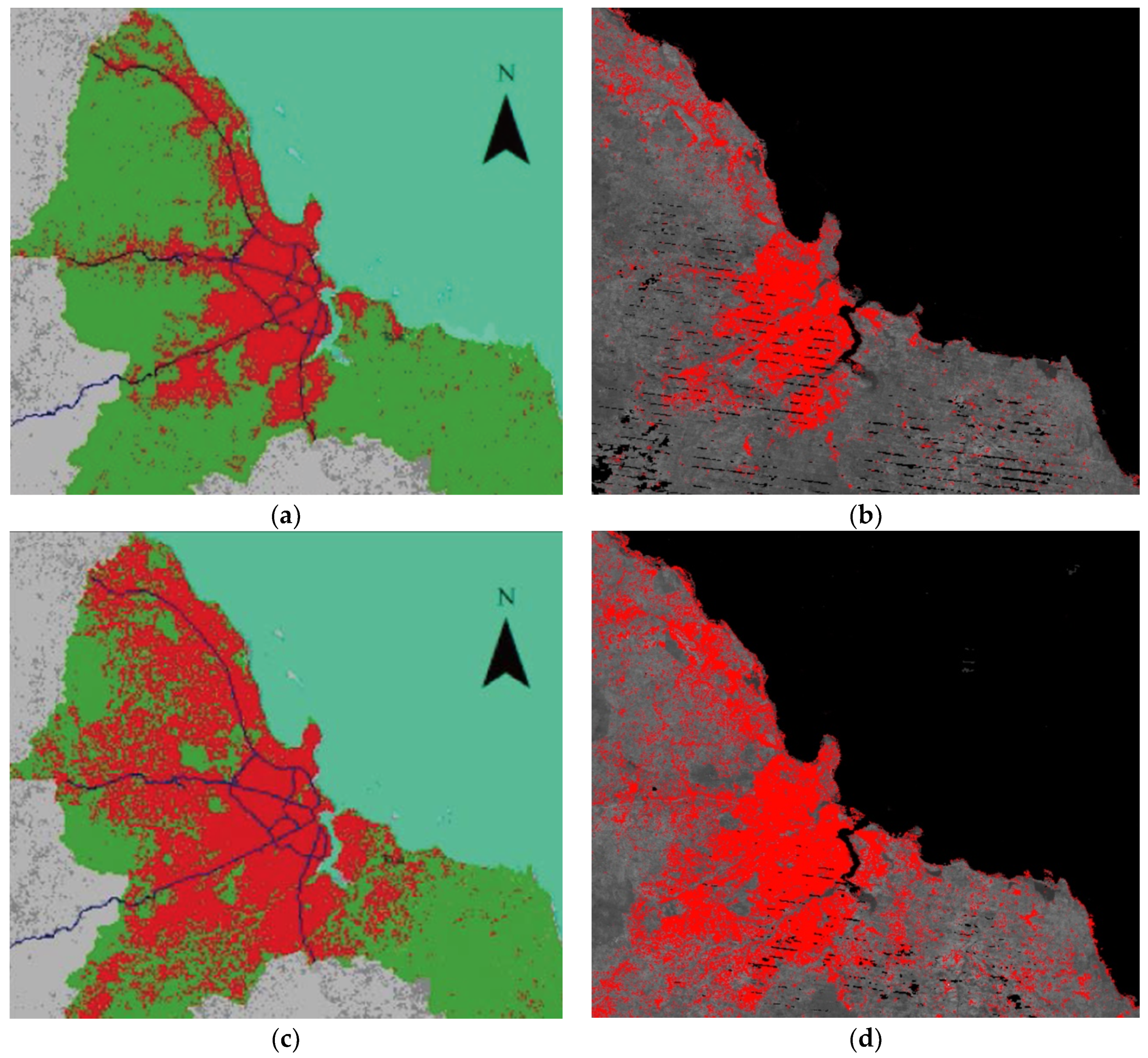
2.4.2. Urbanization in Tanzania
3. Conclusions
Author Contributions
Funding
Acknowledgments
Conflicts of Interest
References
- United Nations. Transforming Our World: The 2030 Agenda for Sustainable Development. Available online: https://www.un.org/ga/search/view_doc.asp?symbol=A/RES/70/1&Lang=E (accessed on 15 June 2019).
- United Nations. System of Environmental-Economic Accounting. Available online: https://seea.un.org/ (accessed on 15 June 2019).
- United Nations Office for Disaster Risk Reduction. Sendai Framework for Disaster Risk Reduction 2015–2030. Available online: https://www.unisdr.org/files/43291_sendaiframeworkfordrren.pdf (accessed on 15 June 2019).
- United Nations. Paris Agreement. Available online: https://unfccc.int/sites/default/files/english_paris_agreement.pdf (accessed on 15 June 2019).
- Committee on Earth Observation Satellites. Satellite Earth Observations in Support of the Sustainable Development Goals. Available online: http://eohandbook.com/sdg/files/CEOS_EOHB_2018_SDG.pdf (accessed on 15 June 2019).
- Committee on Earth Observation Satellites. CEOS Analysis Ready Data. Available online: http://ceos.org/ard/ (accessed on 15 June 2019).
- Committee on Earth Observation Satellites. Product Family Specification, Optical Surface Reflectance (CARD4L-OSR). Available online: http://ceos.org/ard/files/CARD4L_Product_Specification_Surface_Reflectance_v4.0.pdf (accessed on 15 June 2019).
- Committee on Earth Observation Satellites. Product Family Specification, Land Surface Temperature. Available online: http://ceos.org/ard/files/CARD4L_Product_Specification_Land_Surface_Temperature_v4.0.pdf (accessed on 15 June 2019).
- Committee on Earth Observation Satellites. Product Family Specification, Normalised Radar Backscatter. Available online: http://ceos.org/ard/files/CARD4L_Product_Specification_Backscatter_v4.0.pdf (accessed on 15 June 2019).
- United Nations Statistical Division. Earth Observations for Official Statistics Satellite Imagery and Geospatial Data Task Team Report. Available online: https://unstats.un.org/bigdata/taskteams/satellite/UNGWG_Satellite_Task_Team_Report_WhiteCover.pdf (accessed on 15 June 2019).
- Gorelick, N.; Hancher, M.; Dixon, M.; Ilyushchenko, S.; Thau, D.; Moore, R. Google Earth Engine: Planetary-scale geospatial analysis for everyone. Remote Sens. Environ. 2017, 202, 18–27. [Google Scholar] [CrossRef]
- Copernicus. DIAS. Available online: https://www.copernicus.eu/en/access-data/dias (accessed on 15 June 2019).
- Open Data Cube. Available online: https://www.opendatacube.org (accessed on 15 June 2019).
- Killough, B. Overview of the Open Data Cube Initiative. In Proceedings of the IGARSS 2018 - 2018 IEEE International Geoscience and Remote Sensing Symposium, Valencia, Spain, 22–27 July 2018; pp. 8629–8632. [Google Scholar]
- Lewis, A.; Oliver, S.; Lymburner, L.; Evans, B.; Wyborn, L.; Mueller, N.; Raevksi, G.; Hooke, J.; Woodcock, R.; Sixsmith, J.; et al. The Australian Geoscience Data Cube—Foundations and lessons learned. Remote Sens. Environ. 2017, 202, 276–292. [Google Scholar] [CrossRef]
- Dhu, T.; Dunn, B.; Lewis, B.; Lymburner, L.; Mueller, N.; Telfer, E.; Lewis, A.; McIntyre, A.; Minchin, S.; Phillips, C. Digital earth Australia—unlocking new value from earth observation data. Big Earth Data 2017, 1, 64–74. [Google Scholar] [CrossRef]
- Li, F.; Jupp, D.L.B.; Reddy, S.; Lymburner, L.; Mueller, N.; Tan, P.; Islam, A. An Evaluation of the Use of Atmospheric and BRDF Correction to Standardize Landsat Data. IEEE J. Sel. Top. Appl. Earth Obs. Remote Sens. 2010, 3, 257–270. [Google Scholar] [CrossRef]
- Li, F.; Jupp, D.L.B.; Thankappan, M.; Lymburner, L.; Mueller, N.; Lewis, A.; Held, A. A physics-based atmospheric and BRDF correction for Landsat data over mountainous terrain. Remote Sens. Environ. 2012, 124, 756–770. [Google Scholar] [CrossRef]
- Frontier SI. Digital Earth Australia Industry Strategy. Available online: https://frontiersi.com.au/wp-content/uploads/2019/04/FrontierSI_Digital_Earth_Industry_Strategy_March_2019-v2.pdf (accessed on 20 October 2019).
- Frontier SI. Community Focus Key to APSEA Award Success. Available online: https://frontiersi.com.au/community-focus-key-to-apsea-award-success/ (accessed on 20 October 2019).
- Salleh, A. How Satellites and Machine Learning Algorithms Are Helping Farmers to Be More Sustainable. Available online: https://www.abc.net.au/news/science/2019-09-27/machine-learning-and-satellites-help-farms-sustainability/11500214 (accessed on 20 October 2019).
- Murray-Darling Basin Authority. Murray-Darling Basin Authority Annual Report 2017–2018. Available online: https://www.mdba.gov.au/sites/default/files/pubs/MDBA-Annual-Report-2017-18.pdf (accessed on 15 June 2019).
- Murray-Darling Basin Authority. A Plan for the Murray-Darling Basin. Available online: https://www.mdba.gov.au/basin-plan/plan-murray-darling-basin (accessed on 15 June 2019).
- Mueller, N.; Lewis, A.; Roberts, D.; Ring, S.; Melrose, R.; Sixsmith, J.; Lymburner, L.; McIntyre, A.; Tan, P.; Curnow, S.; et al. Water observations from space: Mapping surface water from 25years of Landsat imagery across Australia. Remote Sens. Environ. 2016, 174, 341–352. [Google Scholar] [CrossRef]
- New South Wales Department of Primary Industries. NSW State Seasonal Update—May 2019. Available online: https://www.dpi.nsw.gov.au/climate-and-emergencies/droughthub/information-and-resources/seasonal-conditions/ssu/may-2019 (accessed on 15 June 2019).
- Murray-Darling Basin Authority. A Case Study for Compliance Monitoring Using Satellite Imagery. Available online: https://www.mdba.gov.au/sites/default/files/pubs/Compliance-monitoring-using-remote-sensing.pdf (accessed on 15 June 2019).
- Murray-Darling Basin Authority. Satellites helping to guard against water theft. Available online: https://www.mdba.gov.au/media/mr/satellites-helping-guard-against-basin-water-theft (accessed on 15 June 2019).
- Murray-Darling Basin Authority. Monitoring ‘First Flush’ Flows in the Namoi, Macquarie and Warrego Rivers—Remote Sensing for Compliance and Ecohydrology; Murray-Darling Basin Authority: Canberra, Australia, 2019.
- Swiss Data Cube (SDC) - EO for monitoring the environment of Switzerland in space and time. Available online: https://www.swissdatacube.org (accessed on 15 June 2019).
- Giuliani, G.; Chatenoux, B.; De Bono, A.; Rodila, D.; Richard, J.-P.; Allenbach, K.; Dao, H.; Peduzzi, P. Building an Earth Observations Data Cube: Lessons learned from the Swiss Data Cube (SDC) on generating Analysis Ready Data (ARD). Big Earth Data 2017, 1, 100–117. [Google Scholar] [CrossRef]
- Rizvi, S.R.; Killough, B.; Cherry, A.; Gowda, S. The Ceos Data Cube Portal: A User-Friendly, Open Source Software Solution for the Distribution, Exploration, Analysis, and Visualization of Analysis Ready Data. In Proceedings of the IGARSS 2018–2018 IEEE International Geoscience and Remote Sensing Symposium, Valencia, Spain, 22–27 July 2018; pp. 8639–8642. [Google Scholar]
- Giuliani, G.; Chatenoux, B.; Honeck, E.; Richard, J. Towards Sentinel-2 Analysis Ready Data: A Swiss Data Cube Perspective. In Proceedings of the IGARSS 2018–2018 IEEE International Geoscience and Remote Sensing Symposium, Valencia, Spain, 22–27 July 2018; pp. 8659–8662. [Google Scholar]
- Giuliani, G.; Dao, H.; De Bono, A.; Chatenoux, B.; Allenbach, K.; De Laborie, P.; Rodila, D.; Alexandris, N.; Peduzzi, P. Live Monitoring of Earth Surface (LiMES): A framework for monitoring environmental changes from Earth Observations. Remote Sens. Environ. 2017, 202, 222–233. [Google Scholar] [CrossRef]
- Beniston, M.; Farinotti, D.; Stoffel, M.; Andreassen, L.M.; Coppola, E.; Eckert, N.; Fantini, A.; Giacona, F.; Hauck, C.; Huss, M.; et al. The European mountain cryosphere: A review of its current state, trends, and future challenges. Cryosphere 2018, 12, 759–794. [Google Scholar] [CrossRef]
- Beniston, M.; Stoffel, M. Assessing the impacts of climatic change on mountain water resources. Sci. Total Environ. 2014, 493, 1129–1137. [Google Scholar] [CrossRef] [PubMed]
- Changement climatique et hydrologie. Available online: https://sciencesnaturelles.ch/topics/water/climate_change_and_hydrology (accessed on 1 April 2019).
- Beniston, M.; Uhlmann, B.; Goyette, S.; Lopez-Moreno, J.I. Will snow-abundant winters still exist in the Swiss Alps in an enhanced greenhouse climate? Int. J. Climatol. 2011, 31, 1257–1263. [Google Scholar] [CrossRef]
- Lehmann, A.; Guigoz, Y.; Ray, N.; Mancosu, E.; Abbaspour, K.C.; Rouholahnejad Freund, E.; Allenbach, K.; De Bono, A.; Fasel, M.; Gago-Silva, A.; et al. A web platform for landuse, climate, demography, hydrology and beach erosion in the Black Sea catchment. Sci. Data 2017, 4, 170087. [Google Scholar] [CrossRef] [PubMed] [Green Version]
- Small, D. Flattening Gamma: Radiometric Terrain Correction for SAR Imagery. IEEE Trans. Geosci. Remote Sens. 2011, 49, 3081–3093. [Google Scholar] [CrossRef]
- Small, D.; Miranda, N.; Ewen, T.; Jonas, T. Reliably flattened radar backscatter for wet snow mapping from wide-swath sensors. In Proceedings of the ESA Living Planet Symposium, Edinburgh, Scotland, 9–13 September 2013. [Google Scholar]
- Frau, L.; Rizvi, S.R.; Chatenoux, B.; Poussin, C.; Richard, J.; Giuliani, G. Snow Observations from Space: An Approach to Map Snow Cover from Three Decades of Landsat Imagery Across Switzerland. In Proceedings of the IGARSS 2018–2018 IEEE International Geoscience and Remote Sensing Symposium, Valencia, Spain, 22–27 July 2018; pp. 8663–8666. [Google Scholar]
- Swiss Data Cube Viewer. Available online: http://www.swissdatacube.org/viewer (accessed on 15 June 2019).
- Guigoz, Y.; Palazzi, E.; Terzago, S.; Chatenoux, B.; Poussin, C.; Giuliani, G. Snow cover evolution in Gran Paradiso and Vanoise protected areas using Earth Observation Data Cube. Data 2019, 4, 138. [Google Scholar]
- Asmaryan, S.; Asastryan, H.; Guigoz, Y.; Giuliani, G. Paving the way towards an Aremnian Data Cube. Data 2019, 4, 117. [Google Scholar] [CrossRef]
- Land Use in Switzerland–Results of the Swiss Land Use Statistics; Swiss Federal Statistical Office (FSO): Neuchâtel, Switzerland, 2013.
- Roberts, D.; Mueller, N.; Mcintyre, A. High-Dimensional Pixel Composites From Earth Observation Time Series. IEEE Trans. Geosci. Remote Sens. 2017, 55, 6254–6264. [Google Scholar] [CrossRef]
- Gombe, K.E.; Asanuma, I.; Park, J.-G. Quantification of Annual Urban Growth of Dar es Salaam Tanzania from Landsat Time Series Data. Adv. Remote Sens. 2017, 6, 175–191. [Google Scholar] [CrossRef] [Green Version]
- Thematic Exploration Product, Urban Footprint. Available online: https://urban-tep.eu (accessed on 1 May 2019).
- Guerschman, J.P.; Scarth, P.F.; McVicar, T.R.; Renzullo, L.J.; Malthus, T.J.; Stewart, J.B.; Rickards, J.E.; Trevithick, R. Assessing the effects of site heterogeneity and soil properties when unmixing photosynthetic vegetation, non-photosynthetic vegetation and bare soil fractions from Landsat and MODIS data. Remote Sens. Environ. 2015, 161, 12–26. [Google Scholar] [CrossRef]


© 2019 by the authors. Licensee MDPI, Basel, Switzerland. This article is an open access article distributed under the terms and conditions of the Creative Commons Attribution (CC BY) license (http://creativecommons.org/licenses/by/4.0/).
Share and Cite
Dhu, T.; Giuliani, G.; Juárez, J.; Kavvada, A.; Killough, B.; Merodio, P.; Minchin, S.; Ramage, S. National Open Data Cubes and Their Contribution to Country-Level Development Policies and Practices. Data 2019, 4, 144. https://doi.org/10.3390/data4040144
Dhu T, Giuliani G, Juárez J, Kavvada A, Killough B, Merodio P, Minchin S, Ramage S. National Open Data Cubes and Their Contribution to Country-Level Development Policies and Practices. Data. 2019; 4(4):144. https://doi.org/10.3390/data4040144
Chicago/Turabian StyleDhu, Trevor, Gregory Giuliani, Jimena Juárez, Argyro Kavvada, Brian Killough, Paloma Merodio, Stuart Minchin, and Steven Ramage. 2019. "National Open Data Cubes and Their Contribution to Country-Level Development Policies and Practices" Data 4, no. 4: 144. https://doi.org/10.3390/data4040144
APA StyleDhu, T., Giuliani, G., Juárez, J., Kavvada, A., Killough, B., Merodio, P., Minchin, S., & Ramage, S. (2019). National Open Data Cubes and Their Contribution to Country-Level Development Policies and Practices. Data, 4(4), 144. https://doi.org/10.3390/data4040144