Article

Planetary Defense Mitigation Gateway: A One-Stop Gateway for Pertinent PD-Related Contents

1
Department of Geography and Geoinformation Science, George Mason University, 4400 University Dr, Fairfax, VA 22030, USA
2
NASA/Goddard Space Flight Center, Planetary Science Division, 8800 Greenbelt Road, Greenbelt, MD 20771, USA
3
USRA, Department of Research & Innovation, 7178 Columbia Gateway Drive Columbia, Columbia, MD 21046, USA
4
Los Alamos National Laboratory, Los Alamos, NM 87545, USA
5
National Nuclear Security Administration, Department of Energy / Forrestal Building, Washington, DC 20585, USA
6
Lawrence Livermore National Laboratory, Livermore, CA 94550, USA
*
Author to whom correspondence should be addressed.
Submission received: 8 March 2019 / Revised: 21 March 2019 / Accepted: 23 March 2019 / Published: 28 March 2019
(This article belongs to the Special Issue Data in Astrophysics & Geophysics: Research and Applications)

Abstract

:
Planetary Defense (PD) has become a critical effort of protecting our home planet by discovering potentially hazardous objects (PHOs), simulating the potential impact, and mitigating the threats. Due to the lack of structured architecture and framework, pertinent information about detecting and mitigating near earth object (NEO) threats are still dispersed throughout numerous organizations. Scattered and unorganized information can have a significant impact at the time of crisis, resulting in inefficient processes, and decisions made on incomplete data. This PD Mitigation Gateway (pd.cloud.gmu.edu) is developed and embedded within a framework to integrate the dispersed, diverse information residing at different organizations across the world. The gateway offers a home to pertinent PD-related contents and knowledge produced by the NEO mitigation team and the community through (1) a state-of-the-art smart-search discovery engine based on PD knowledge base; (2) a document archiving and understanding mechanism for managing and utilizing the results produced by the PD science community; (3) an evolving PD knowledge base accumulated from existing literature, using natural language processing and machine learning; and (4) a 4D visualization tool that allows the viewers to analyze near-Earth approaches in a three-dimensional environment using dynamic, adjustable PHO parameters to mimic point-of-impact asteroid deflections via space vehicles and particle system simulations. Along with the benefit of accessing dispersed data from a single port, this framework is built to advance discovery, collaboration, innovation, and education across the PD field-of-study, and ultimately decision support.

1. Introduction

Near-Earth objects (NEOs) are asteroids, comets, and large meteoroids, and some of their orbits may intersect Earth’s orbit and may, therefore, pose a collision danger. NEOs are composed of mostly water ice with embedded dust particles. Many physical characteristics can be defined and measured for NEOs, both for asteroids and comets (such as albedo, brightness, shape, and phase). The scientific interest in comets and asteroids is mainly due to their possible collision with our planet, representing a hazard to life on Earth [1]. As many scientific types of research highlight, impacts of NEOs have contributed to mass extinctions and evolution. Moreover, it is a proven fact that NEOs will continue to hit the Earth at irregular intervals in the future [2]. The impactors range from benign fireballs, through the largest airbursts, to globally disastrous destruction on the ground, which are very unlikely to occur in any given lifetime but are probably randomly distributed in time. For events of harmless fireballs, the methods of civil defense are sufficient for saving human lives. For more massive airbursts, changing the path of the near-Earth objects reaching the Earth’s vicinity is the appropriate solution. For the global catastrophic events that cause mass extinctions, there is no current technology capable of avoiding disaster [3].
Several studies and explorations have been established in global organizations to mitigate the potential impact of near-Earth objects. Programs like NASA’s NEO Survey share necessary information with the public that can be utilized to support decision-making for impact mitigation. A few NASA-funded astronomer teams are always searching for potentially hazardous near-Earth objects whose orbits periodically bring them within 30 million miles of Earth’s orbit. At NASA, the Planetary Defense Coordination Office supports the search programs, while also planning and coordinating any response to possible asteroid impacts. As part of NASA’s planetary defense strategy, the Center for Near Earth Object Studies at JPL analyzes the data collected on near-Earth objects and publishes the data and types discovered [4]. Numerous efforts can be taken to mitigate the hazard of potential asteroid impacts which includes emergency response planning, civil defense, slow-push or pull methods, kinetic impact, deflection mission concept studies, and nuclear detonation. The European Union’s NEOShield Project is considering kinetic impactor options, last deflection techniques, and gravity-tractor methods. The impact effects are currently being studied at some of the Department of Energy’s national laboratories. The Planetary Defense Coordination Office (PDCO) is collaborating with other U.S. Government agencies and other national and international agencies to ensure the early detection of potentially hazardous objects [5].
Currently, information about detecting, characterizing, and mitigating NEO threats is dispersed throughout different organizations and scientists, due to the lack of organizational leadership and structured architecture. This dispersion can cause errors at the time of crisis, resulting in miscalculated mitigation efforts. A unified platform can help streamline the complexity of this dispersion, save crucial research-time, and allow researchers to make decisions on competent data. The objective of this research is to provide insights on the one-stop shop gateway for planetary defense mitigation-related data and information, available at pd.cloud.gmu.edu, built on a PD knowledge base, information mining, and reasoning mechanism. It further provides a knowledge discovery engine and interactive visualization tool to better assist the development and integration of a NEO Mitigation responding system. This knowledge discovery engine will serve as a cyberinfrastructure building block for different patches of existing knowledge (for example data, service, and model). By integrating, extracting, analyzing, and providing knowledge dispersed throughout different organizations and scientists, this PD Mitigation Gateway is expected to advance in discovery, innovation, and education across government agencies and scientific communities. This gateway can become a powerful resource for scientists by providing a 5D visualization tool for mitigation that includes access to x, y, z, time, and uncertainty variables. The tool currently provides 4D (x, y, z, time) capabilities, and the uncertainty calculation functionality is under development.

2. Literature Review

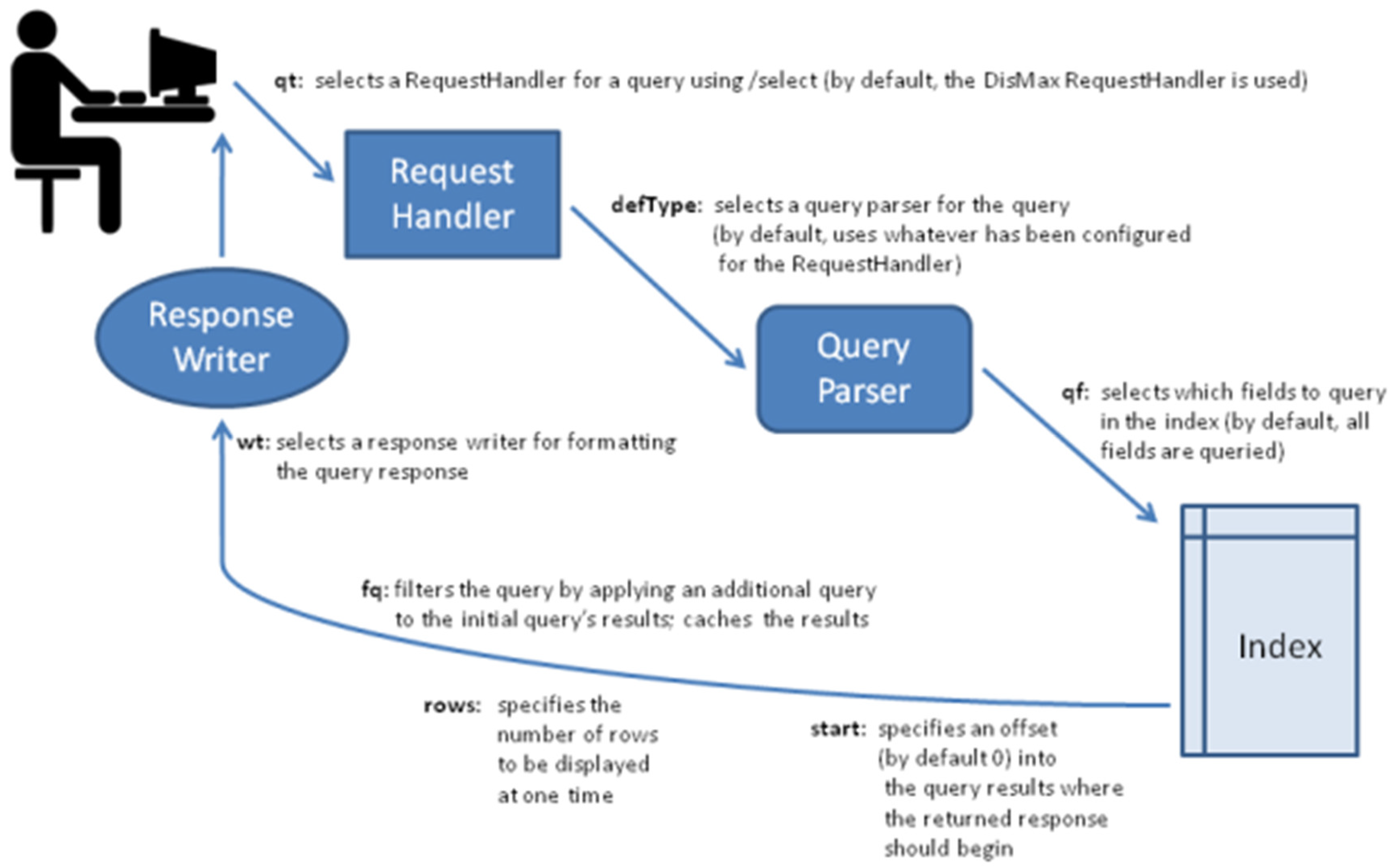
2.1. Searching Capabilities in Planetary Defense

Search engines have always played an essential role in the evolution of information science, aiming to aid users in discovering required information efficiently and accurately from the massive available data. From the day it existed, it changed the way people search and collect information. Besides universal search engine (e.g., Google, Bing), multiple vertical domain search engines such as e-commerce website Amazon and oceanography data portals PO.DAAC (Physical Oceanography Distributed Active Archive Center), etc., have been developed to provide a customizable searching capability for users from specified domains or with the same information objectives [6]. Domain search engine associated crawlers and data storages are dedicated to a specific domain, and thus saving time for users to find useful information within the enabled searching capability.
Much attention has been paid for search relevancy as it is one of the most important capabilities of search engines. Apache LuceneTM or other open-source products built on Lucene like Apache SolrTM or ElasticsearchTM [7] have provided efficient solutions to build search engines with full-text search capabilities [8]. A Boolean model is designed in Lucene to match documents to the query, and a relevance score is calculated by the practical scoring function. Figure 1 summarizes some key elements of the search process applied in the development stack. In the geoscience domain, many data portals within have been implemented with these open source solutions instead of developing them from scratch. For example, the PO.DAAC search engine builds upon SolrTM, and NOAA’s OneStop search platform relies on ElasticsearchTM [9].

2.2. Visualization in Planetary Defense

Data visualization is not a new concept, and it has been evolved over time. Maps, charts, and diagrams have been presenting complex information in a graphical or pictorial format for over a hundred years. Visually represented information helps us to understand why things are happening, as well as compare different patterns and trends that could inform future outcomes. The Planetary Society recognizes the threat that asteroids and comets represent [10]. There are approximately 1800 potentially hazardous objects (size > 140 m, the minimum distance to Earth < 0.05 AU) that have been cataloged [1], but this number is increasing. In the U.S. there are currently three ground-based NEO-search programs to monitor, track, and discover NEOs via some form of visualization. PDCO oversees cataloging and tracking potentially hazardous NEOs, such as asteroids and comets that are larger than 30 meters in diameter (compare to the 20-meter Chelyabinsk meteor), and coordinating an effective threat-response and -mitigation effort.
There are numerous tools to monitor the solar system in the PD community; some of the most highly acknowledged tools are mentioned in Table 1.

2.3. Integrated Data Resource Discovery for Planetary Defense

An integrated data resource discovery engine is essential for applications like PD Mitigation Gateway as it encourages researchers to collaborate and share their findings with the entire PD community. It provides benefits such as (a) a secure, more reliable environment; (b) an effective way of sharing information and resources; and (c) the capability of accessing documents at any time. There are numerous data resource tools that help users to share and receive files from local computers via the Internet or a local network. These solutions can be applied to share various kinds of files, such as documents, videos, and images. Most file-sharing services have evolved into immersive collaboration platforms. Some of the biggest service providers of such kind are as follows: Google Drive, Microsoft OneDrive, Box, Dropbox, and SugarSync. In the education field, many institutes have used at least one form of a digital repository to provide data to the public. Figshare is one of the tools used by numerous organizations and institutes such as the University of Adelaide to preserves and shares community’s research outputs, including figures, datasets, code, posters, and presentations [16].

2.4. How Are We Different from Other Domains?

As an emerging field of study, PD does not yet have a specific domain search engine, meaning scientists within this domain can only collect information from universal search engines such as Google or Bing. In this research, a PD vertical search engine is proposed and developed based on Elasticsearch to help PD scientists collect useful information from the Internet quickly.
Though Lucence plays a vital role in the search relevancy, it only focuses on the text content, and some useful information is ignored during the searching process. In the field of geoscience, many data portals adopt the default Lucence relevance ranking and provide additional attributes (e.g., monthly popularity, release time) to re-rank the returned results. Jiang et al. [17] proposed a smart search engine for oceanographic data discovery by leveraging knowledge learned from metadata and user logs, which proved to be useful for improving the performance of Elasticsearch. However, it is not adaptable for this research due to the lack of metadata and usage logs within PD data. The PageRank Ranking algorithms proposed by Page [18] have led the advancement in optimizing the search capabilities of search engines, and therefore, the PageRank scores are applied to enhance the PD search engine. This project also leverages semantic search techniques from our previous research, which allows our smart search engine to be robust and unique.
As introduced in the previous sections, it is also crucial to incorporate a data resource discovery component that can provide a shared digital repository for the PD science community—a shared space for hosting PD-related scientific publications. As of now, tools of a similar kind are either expensive or do not provide services for small niches like PD. In terms of visualization, although numerous solar system visualization tools are already in the market, they mainly focus on visualizing the planets. Some of the tools do track near-Earth objects in real-time and provide an accurate representation of the NEOs orbit. However, they are either not accessible via the web, or have costs associated with it. In contrast, our visualization tool depicts an accurate representation of asteroid’s orbital path that can allow scientists to make better judgments on the mitigation efforts. It also adopts the latest advancement in natural language processing and semantic search. Our web-based visualization tool uses modern technologies such as gulp.js [19] and Three.js [20] to take advantage of faster rendering speed with small memory resource consumption. Furthermore, it provides enhanced navigation around the solar system, with more relevant information regarding each asteroid in our 4D visualization, which includes asteroid orbit tracker information, physical attributes including the object shape, and much more.
The following sections explore the methodologies applied to the development of our smart search engine, a 4D visualization tool, and an integrated data resource discovery tool. It explains why our gateway provides a significant advantage against the current tools that are available on the web. Under the same section, this paper discusses (1) the PD framework architecture in depth; (2) the ontology structure used to build smart search algorithms; (3) the solution to provide an online file depot for PD resources; (4) NEOs trajectory calculations used for 4D visualization; and (5) the vocabulary repository. The system integration and demonstration are discussed in the latter part of this paper, along with its future-plan.

3. Methodologies

The following is a detailed description of each part of the architecture for NEO mitigation. Section 3.1 introduces the current architecture of the Planetary Defense Mitigation Gateway and the data transmission workflow. Section 3.2 describes the methodologies used in our smart search engine. Section 3.3 provides an overview of the ontology structure used to build our knowledge base. Lastly, Section 3.4 elaborates on the orbital elements and formulas used to accurately represent the solar system.

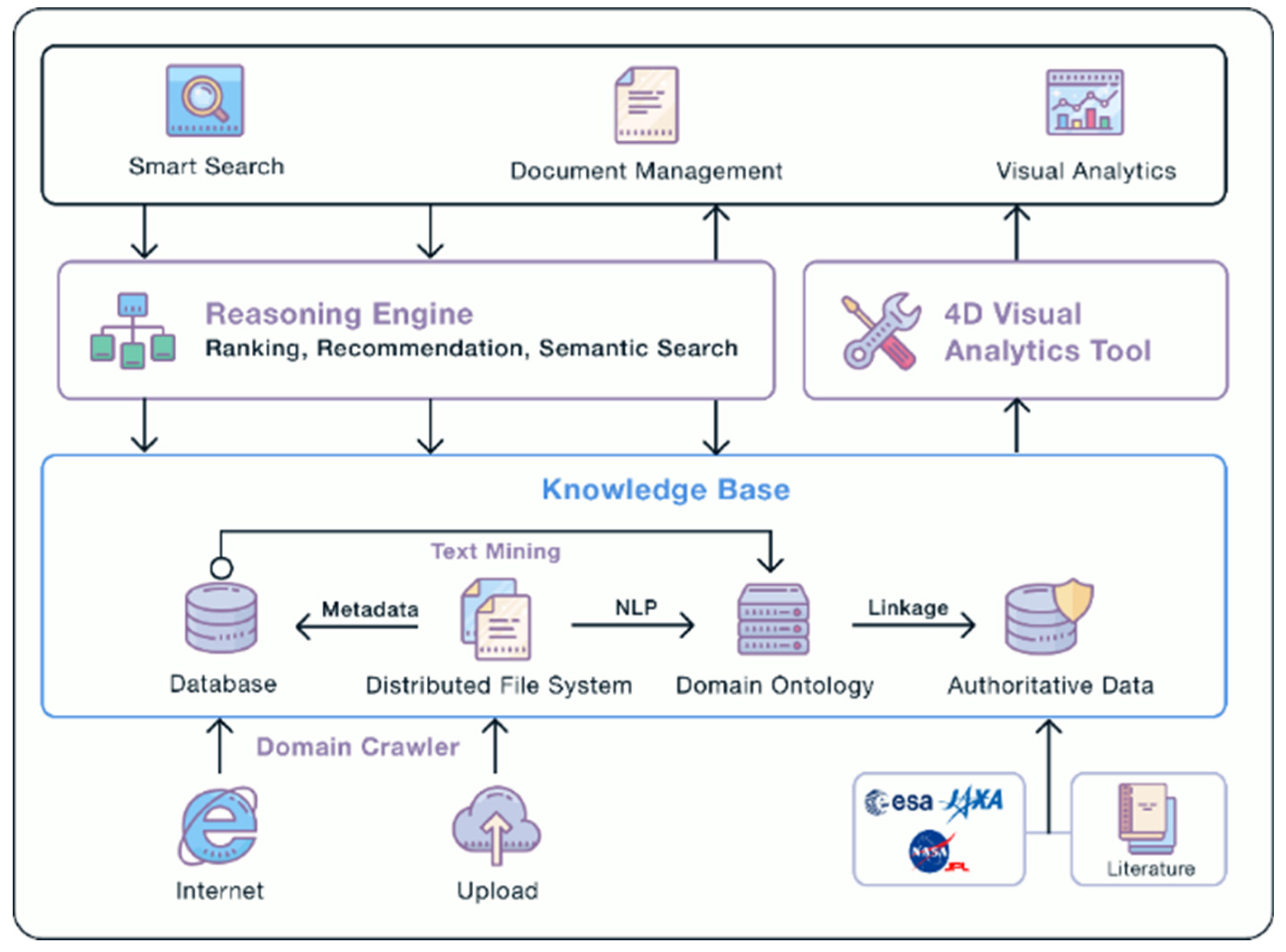
3.1. Planetary Defense Mitigation Gateway Architecture
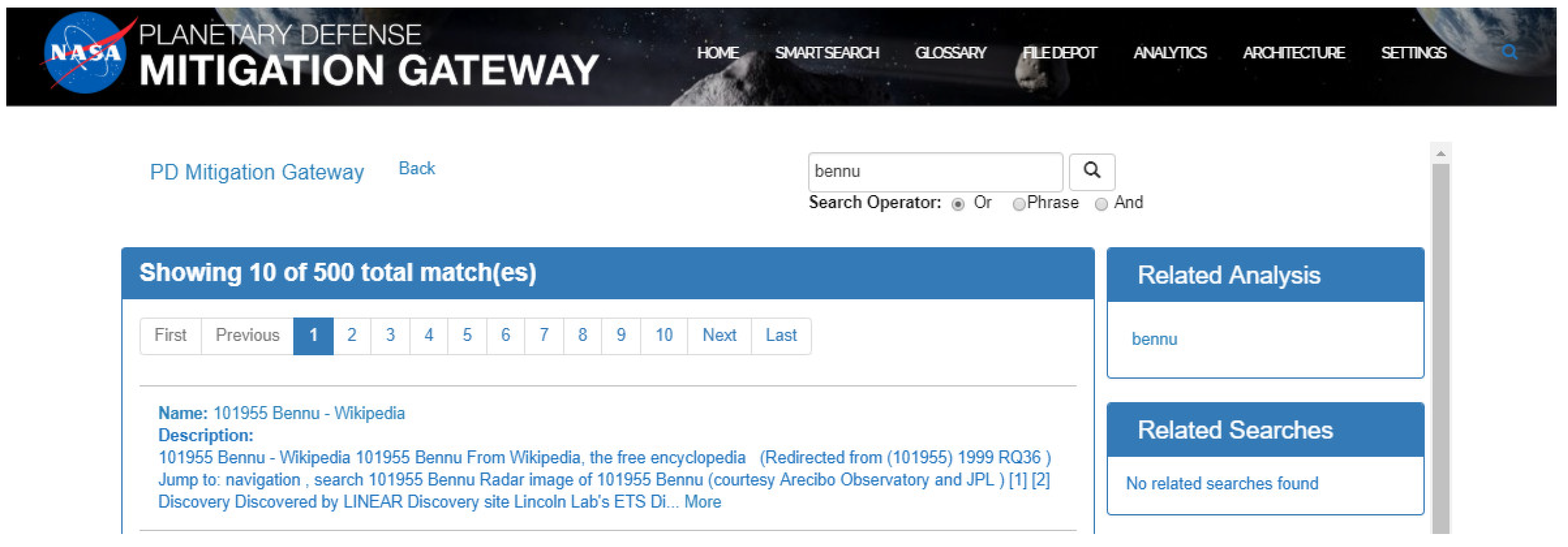
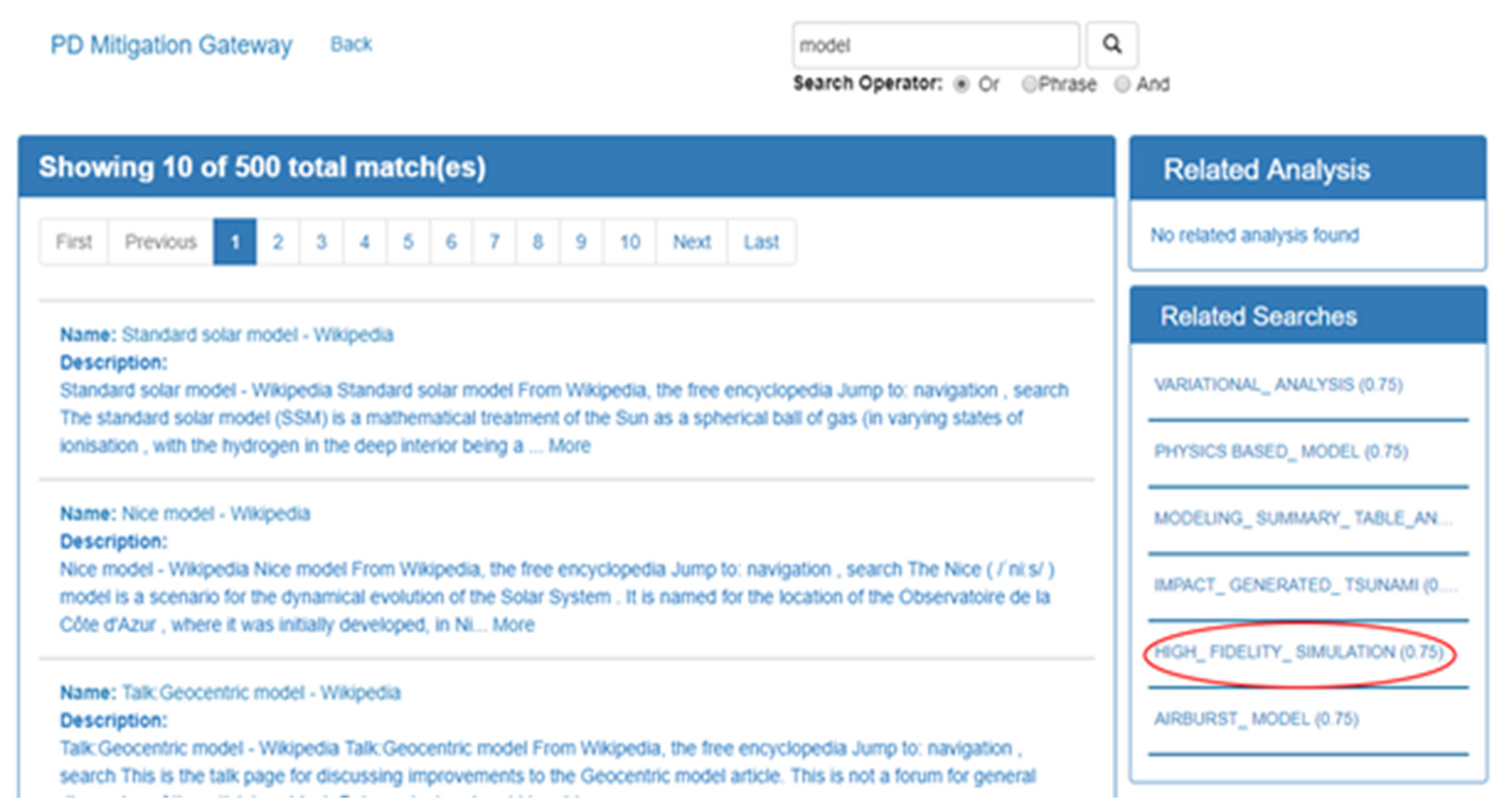
The PD Mitigation Gateway is a cloud-host online system, integrating multiple functionalities [21] to facilitate the efforts of NEO mitigation, as shown in Figure 2.
The overall flow of the PD Framework is relatively streamlined, with different stages generating different data and information to form the overall mitigation product. The first step of the PD process starts at the bottom of the architecture where the users upload PD-related contents. Additionally, our gateway also uses a web crawler to data from authoritative sources such as the National Aeronautics and Space Administration (NASA), European Space Agency (ESA), and Japan Aerospace Exploration Agency (JAXA). These data are later injected to our knowledge base (KB). Our KB includes a database that stores metadata; a distributed file system that stores publications; domain ontology powered by Apache Nutch; and authoritative data linkage system. The controllers that process our KB components interact with another tier of engines: The reasoning engine and 4D Visual Analytics Tool. The reasoning engine performs ranking, recommendation, and semantic tasks. It also parses the results in our smart search and document management user interface. On the other hand, 4D visual analytics tools interact with our WebGL-based 3D environment to display real-time solar system visualization.

3.2. Smart Search

The search engine consists of three components: (1) A query expansion module in which a user query is converted to a semantic boosting query based on a similarity calculator; (2) an Elasticsearch search engine which builds a full-text index for web pages; and (3) a ranker module which re-ranks results retrieved by the default search engine.
Query expansion is the process of modifying the original query to incorporate it with its synonym or abbreviation to improve the recall of a search engine. The ontology database serves a search engine with essential resources for query expansion since it includes terminologies and their relationships (i.e., EquivalentClassOf, SubClassOf, etc.) defined by domain experts. As introduced above, a domain ontology has been created for the PD platform, containing 146 PD concepts and relationships among these concepts, i.e., “SubClassOf” (Hyponymy) as shown in Figure 3.
Jiang et al. [23] proposed two methodologies to measure concept similarity in the ontology with the following two equations:
s i m ( X Y ) =   e D i s t ( X Y ) + e
D i s t ( X Y ) = i E d g e ( T y p e i )
where Edge (Type) indicates the relationship between two concepts.
If the relation is “SubClassOf,” the function returns 1, and otherwise returns infinity. The distance between X and Y is measured by accumulating the value of Edge function (Equation (1)). The following constant is introduced to adjust the final similarity, which is useful to accommodate ontologies with varying resolutions. The similarity between two concepts ranges from 0–1. A hyperparameter could be used to filter and expand a query with its similar concepts whose similarity are larger than the predefined value, e.g., 0.8.
In the query expansion module, the original query is converted to a new query containing the original query and its similar concepts. At the query time, the Elasticsearch search engine takes the rewritten query (on the left) and translate it to a semantic query (on the right) as shown in Figure 4, in which a boosting query in Elasticsearch is leveraged to represent the semantic query. The Elasticsearch engine then coordinates the search against the full-text index with Lucene useful scoring function. The boost value in the query, e.g., the value in the should clause will be considered, and a more substantial boost value will result in a higher relevance score.
The Elasticsearch engine would return the top K related pages to the boost query. These results are ranked only by the Lucene possible score, which only takes the web pages’ contents into account. Some information is ignored during the process, e.g., the implicit linkage between these data, the release date of the webpages, user’s preference to the content. Since the vertical search engine is a newly created, the only available data are those web pages collected from the Internet. User behavior data are not available at the current stage, though they are valuable. In addition to title and content, a web page also contains a list of links to other pages, which is the key-data source for the PageRank algorithm [18]. PageRank is a link analysis algorithm which aims to critique web pages with link structures and rank pages in accordance with their importance and authority. Each link is considered as a vote; some votes are considered more important than others and represented by a higher PageRank. A webpage earns a high PageRank if it is linked by many relevant pages or by other pages with high PageRanks. Thus, the domain PageRank score of all collected pages are calculated in advance and is accompanied by the practical-score to re-rank the results to provide an initial ranking list. As long as the search engine is deployed in the production environment, usage data will be collected when the user interacts with the system; then the machine learning based method can be utilized to optimize the ranking results [24].

3.3. File Depot

A well-designed file system helps with organizing and managing information and can accelerate the information sharing and retrieving process; therefore, a File Depot powered by the WordPress File Manager plugin was integrated when designed. This advanced file system enables users with the permitted privilege to have full capacities of file uploading/deleting, quick mate information preview, full article browsing, and downloading.
The file depot is constructed as an embedded webpage. Guarded with user-password protection to maintain the system security, hiding the dashboard from those who do not have admin access to the gateway. Administrative system user has the highest authority to set privilege levels and manage accounts for all other viewers. Once logged in—like the Windows File Explorer—users can expand the browsing window and have full controls over file management as previously introduced. All files uploaded are stored at a specified location on the back-end server with expandable storages (enabled by network volume mounting[j1]) and can be searched from a user-friendly interface either by a filename or by the MIME [j2] type. Files can also be sorted by name, size, or date to serve better file organizing.
Publications and multimedia resources related to the PD domain are expected to be well integrated through this file storage mechanism, whether it is self-uploading from users or collection from administrators. This functionality allows the gateway to have its own information depot with easy access to resourceful materials, including multi-format documents such as (.DOC, .PPT, .CSV, .PDF), images, videos[j3], etc.

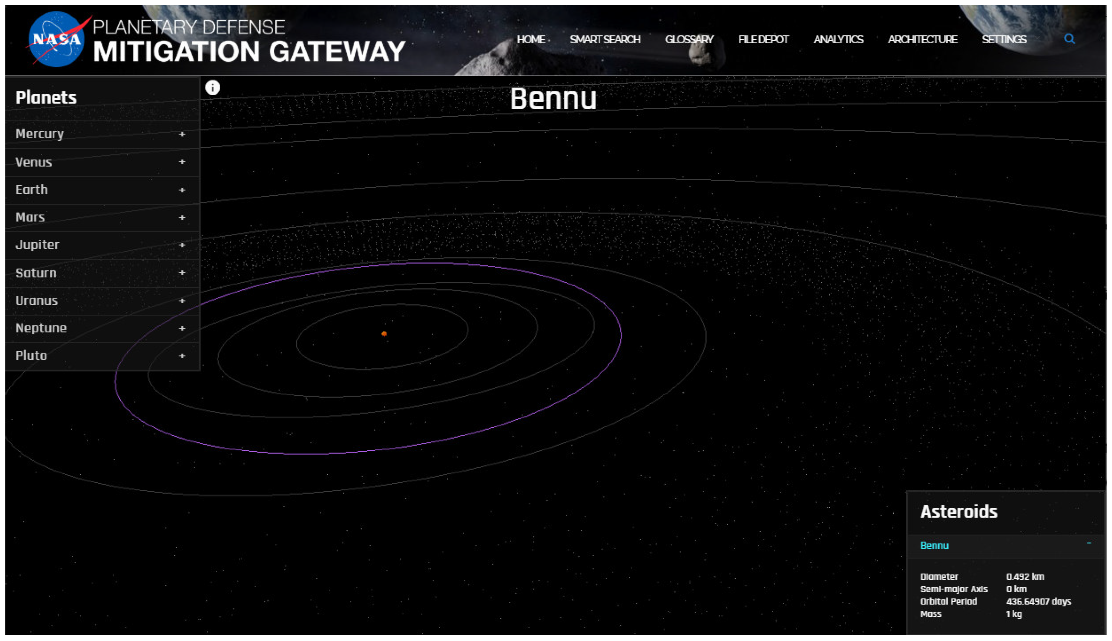
3.4. 4D Visualization

Our visualization tool displays the solar system in a 3D environment. It renders the Sun, the other eight planets and their natural satellites, dwarf planets, and a few chosen NEO use-cases. The scene also displays the asteroid and the Kuiper belt. Unlike most of the tools mentioned in Table 1, this tool is web-based, powered by Three.js and WebGL to provide quick access to PD researchers. All objects within this visualization tool have been modeled to scale based on real astronomical data acquired from the HORIZONS Web-Interface [25]. This tool is integrated with the PD smart search engine, which allows users to view discovered asteroid use-cases from the search results directly.
In order to build an accurate representation of the solar system and NEOs, it is crucial to calculate the positions of the planets, the orbits of the asteroids, understand WebGL frameworks, formula-rendering, and data-injection. The first step was to acquire raw data from NASA JPL HORIZONS [25]. The ephemeris system provides access to key solar system data, which includes over 780,000 asteroids, all planets, and the Sun. It also provides functionality to define custom objects that can be used to integrate the trajectory or conduct parameter searches of the asteroid database. Close-approaches by asteroids and comets to planetary bodies can also be identified, along with the encounter uncertainties and impact probabilities and the table output. After collecting the data, the following step involved computing a planet’s position from its orbital elements.
The subsequent description helps to understand the processes of computing the positions of the Sun, Moon, and the rest of the major planets. Positions of other celestial bodies such as comets and asteroids were computed as well. The timescales represented in the tool were counted in Julian Day Number. We stored the observation EPOCH time from Horizons and calculated the difference against the real-time Julian Day Number.
Other than the time, the orbital elements were also used to compute the planet’s positions [26], denoted in Table 2 and Table 3.
To compute the planet’s position in 3-dimensional space, the visualization tool used these functions [27]:
x h   =   r   ×   (   c o s ( N )   ×   c o s ( v + w )     s i n ( N )   ×   s i n ( v + w )   ×   c o s ( i )   ) y h   =   r   ×   (   s i n ( N )   ×   c o s ( v + w )   +   c o s ( N )   ×   s i n ( v + w )   ×   c o s ( i )   ) z h   =   r   ×   (   s i n ( v + w ) ×   s i n ( i )   )
For asteroids, the orbital elements are often given as N,i,w,a,e, and M are valid for a specific epoch. For our visualization tool’s simplified computational scheme, the only significant changes with the epoch occur in N. The following formula was used to convert N_Epoch to the N (today’s epoch), where the epoch is expressed as a year with fractions.
N   =   N _ E p o c h   +   0.013967   ×   (   2000.0     E p o c h   )   +   3.82394 E 5   ×   d
The PD Mitigation Gateway used three.js; a cross-browser JS library used to create and display animated 3D computer graphics. Three.js is currently the most used WebGL tool in the 3D community. The visualization tool also consisted of some other libraries: (a) jquery; (b) underscore; (c) backbone.js; (d) gulp; (e) tween; and (f) require.js. The application has been programmed using object-oriented programming principles, categorized by controllers, environment, extensions, factory, listeners, models, modules, vendor, views, and data. The solar system attributes that were retrieved from JPL Horizons were converted into JSON objects and stored in the “solarsystem.json” file.
These JSON objects are pushed into the factory controllers’ queue to generate the entire 3D environment on the web. Since the visualization tool is a memory intensive application, Gulp—a library also mentioned earlier—was used. Gulp is renowned for generating fast builds, and it enforces strict guidelines to ensure plugins work as expected.

3.5. Vocabulary Repository

It is critical to have a domain ontology or at least a vocabulary repository to provide a common understanding of specific domains that can be communicated between people and application systems. This is especially true for planetary defense community because it is highly inter-disciplinary when it comes to knowledge integration and mitigation. To the authors’ knowledge, there is no established ontology for planetary defense knowledge integration; therefore, we construct a vocabulary repository of 146 concepts describing the semantics of the information related to NEO observation, NEO characterization, NEO impact modeling, and decision support and mitigation. These vocabularies range from sample NEOs (e.g., Bennu) to observatories (e.g., Arecibo Observatory), from impact modeling (e.g., airburst modeling) to disruption strategies (e.g., NED Deflection).
The construction process of this vocabulary repository is as follows. Firstly, we specified the scope and purpose of this vocabulary list, which is to support the better knowledge integration, search, and access for the entire gateway. Secondly, we identify the most commonly used vocabulary (totally 146) in the planetary defense community. Definitions for these vocabulary items are summarized and identified based on government reports and scholarly publications with trackable references. Thirdly, we define the relationship among the vocabularies regarding classes and subclasses. These relationships are represented as ‘is-a,’ ‘part of’, and so on.
We utilize Protégé as the representation language to construct such vocabulary repository. Protégé [28] is a knowledge-based development framework that offers classes, slots, facets, and instances as the building blocks for representing knowledge. Protégé can generate OWL or RDF, and this PD vocabulary repository is generated as an OWL.
We are actively evolving this vocabulary list for better completeness and support of the gateway’s functionalities. The completeness of the repository will be assessed and verified with the help of manual inspection from the domain experts and the automated tools of data search and access. The process of construction and validation for the vocabulary repository will be repeated, and changes from the experts will be incorporated.
We also document the vocabulary repository for effective knowledge sharing. Documentation is conducted with care and records all the assumptions that are made explicitly. An example of the documentation is given in the following Table 4.

4. System Integration and Demonstration

4.1. System Integration

4.1.1. Smart Search and Visualization Tool

The PD Mitigation Gateway has multiple core functionalities integrated with each other in a loosely-coupled fashion to deliver a higher performing search engine with a holistic view of the search results. Spatiotemporal visualizations and knowledge discovery were addressed in this framework to provide intuitive information with visual effects to decision makers for better mitigation, coordination, and mission assessment. For implementation, Apache Nutch is adopted to crawler PD-related web pages from the internet, and Elasticsearch is used to save these pages with a full-text index. Each web page’s PageRank score is calculated by the PageRank algorithm provided by MLlib, an Apache Spark’s scalable machine learning library. The smart search engine UI was designed and developed with Angular—a framework that was built with Model-View-Controller architecture in mind, allowing engineers to control two-way data binding and dependency injection [29]. Two-way data binding allows the model to change in the view, as the core data changes [30]. Dependency injection allows different pieces of code to interact with each other. We were able to use the injectors to define our 4D visualization objects as external components. The smart search architecture logic was set up to detect asteroid-keywords from the search results and compare them against our asteroid database. If the keyword exists in our visualization component, then the “Related Analysis” component creates a direct link to the “Analytics” component, allowing viewers to look at the asteroid orbiting in the solar system. Figure 5 indicates search results of “Bennu” within PD smart search engine along with the “Related Analysis” component detecting the keyword as an asteroid object. Figure 6 shows the generated dynamic 4D environment obtained from the smart search.

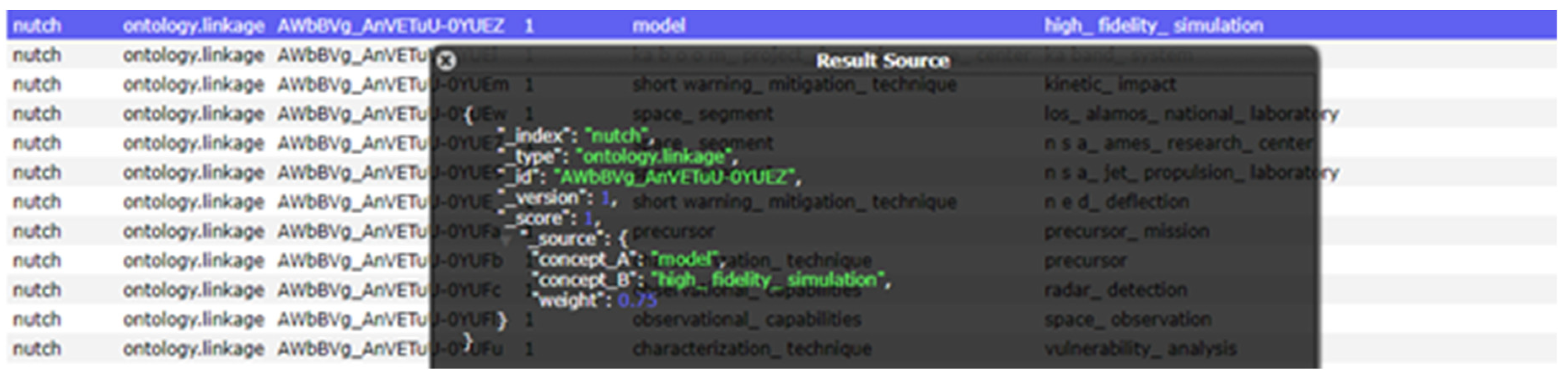
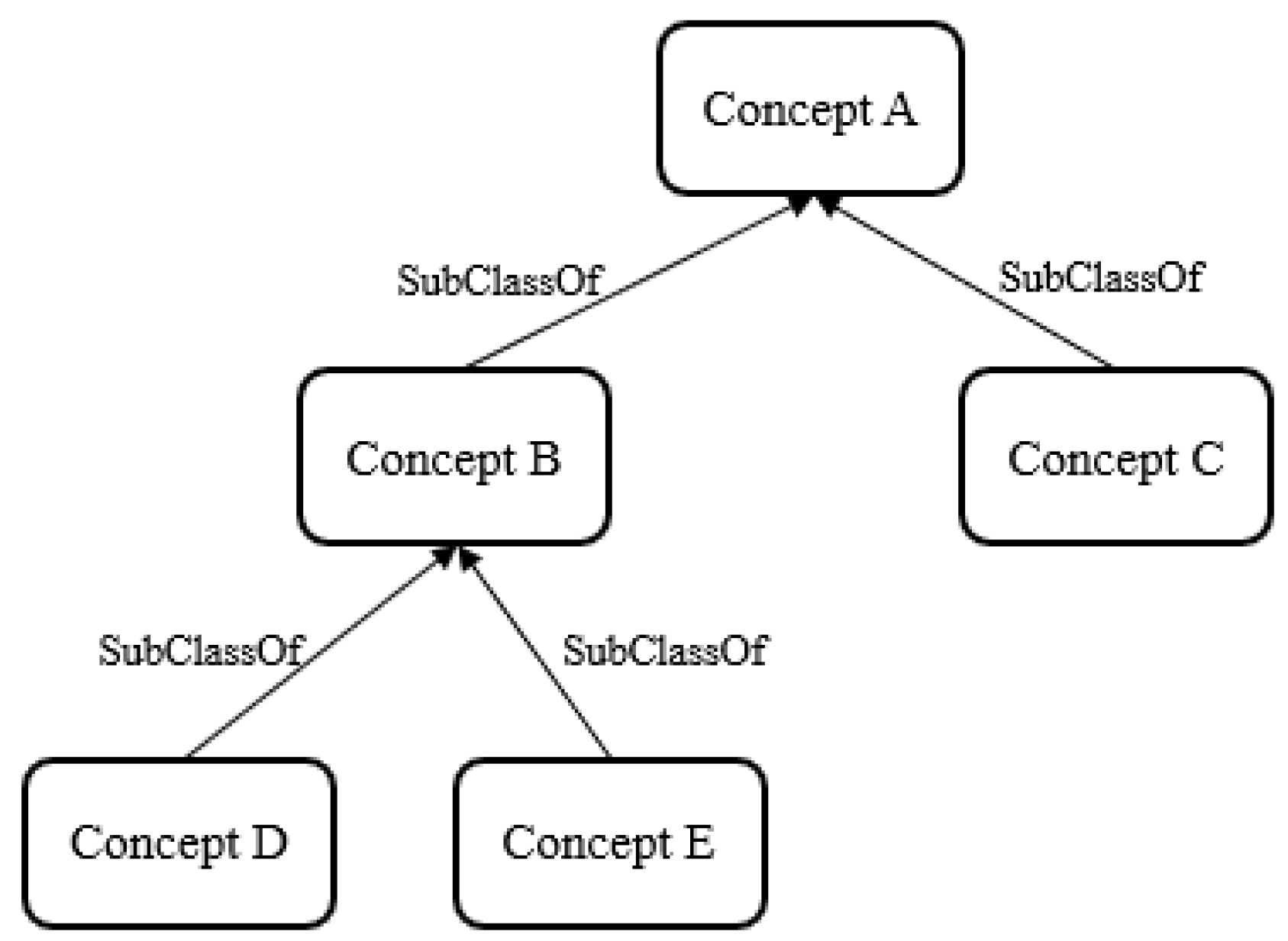
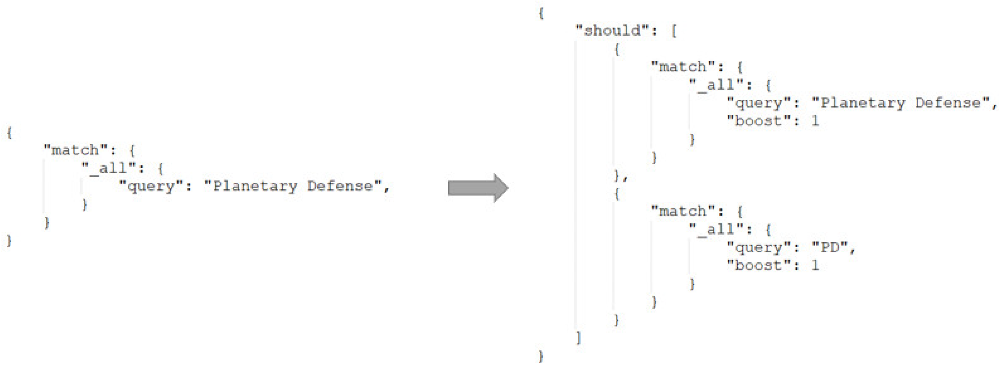
4.1.2. Ontology Integration

For a better demonstration of the knowledge base ontology for the PD domain, a glossary is integrated with all the 146 vocabularies as a repository to this gateway. Vocabularies are initially sorted by number and alphabet when displayed with abstracted descriptions. Most descriptions are statements with references as discussed in the methodology section for vocabulary repository construction, which is listed at the end of the glossary so that users can trace back to the original links or publications for detailed information. The search function is enabled to find specific vocabularies as indicated in Figure 7. The result shows all relevant records and not only entries that contain keywords in the queried phrase, but also those involve the keywords in their descriptions.
The ontology associated with Smart Search supports related search suggestions, offering convenience for users to explore other possible keywords from vocabulary repository. As Figure 8 demonstrates, related searches for “model” are “VARIATIONAL_ANALYSIS,” “PHYSICS BASED_MODEL”, and “HIGH_FIDELITY_SIMULATION,” etc. All relatives are followed by a score indicating relevancy, which is pre-calculated based on the research from Jiang et al. [31], for the relations among vocabularies within PD ontology. The general process of generating these correlations is to establish a pairing relationship between every two words using PD OWL (Section 3.5) and use scores to indicate the closeness between the two, as Figure 8 illustrates, the weight for “model” and “high_fidelity_simulation” is 0.75, which was used for ranking the related search results in Figure 7.

4.2. Visualization Tool Demonstration

The visualization analytics tool shows a solar system map with the camera facing the planets from a slanted-top angle. This program renders in 60 frames per second allowing the users to view smoother contents. Unlike other planetarium software, our tool allows users to travel throughout the solar system. The exponential zoom feature lets users explore space across a huge range of scales. A point-and-click interface makes it simple to navigate through the universe to the preferred planet or a NEO. All objects within this project have been modeled to scale based on real astronomical data. The following Table 5 provides information regarding the project scale and controls:
The position and movement of solar system objects are calculated accurately in real-time at any rate desired. Additionally, all solar system objects are mapped with high-resolution textures, as well as 3D models for asteroids on precise trajectories.

5. Conclusions and Future Enhancements

Near-Earth objects (NEOs) present a significant threat to our planet and humankind. There have been numerous scientific discoveries that are taking place over the past few years to respond to such threats. However, these discoveries and studies are scattered across the entire world wide web. The Planetary Defense Mitigation Gateway solves the problem of dispersion, by becoming a hub for pertinent PD-related data. This platform provides a central gateway for discovery domain knowledge and easy access to experts’ opinions within the project team and factoring in related information from other research and analysis activities. This paper discussed the concepts and methods used to build a robust smart search, interactive visualization tool, and an adaptive knowledge base.
In the future, we plan to include a dynamic mitigation scenario simulation based on rocket trajectory values and deflection variables to our visualization tool. We will incorporate 3D models of NEOs captured by satellite imageries. Currently, our environment only supports 4D (x, y, z, and time variables), and the “uncertainty” variable is missing from the system. On the next iteration, we will focus on including the uncertainty aspect of trajectory as well. Additionally, we will also incorporate more NEO use-cases from the PDC Conference. With respect to our smart search module, we plan to improve the web crawler, enhance search performance, and invite domain experts to evaluate the results. Our planetary defense knowledge base will also be improved via latent semantic analysis methodologies. In summary, this project will continue to push and expand the knowledge of the PD efforts and further organize the complex system in order to increase efficiency.

Author Contributions

Data curation, L.O., R.L. (Ronald Leung) and C.P.; Formal analysis, M.Y., J.N., L.O., K.C.G. and M.B.S.; Funding acquisition, C.Y. and B.D.S.; Investigation, C.Y. and M.B.; Methodology, I.S. and M.Y; Resources, R.L. (Ruthan Lewis); Software, Y.L. and J.Y.; Supervision, C.Y. and M.B.; Visualization, I.S.; Writing—original draft, I.S., Y.L. and J.Y.; Writing—review & editing, C.Y.

Funding

This project is funded under NASA Studies of Short Time Response Options for Potentially Hazardous Objects (PHOs) through NSF (NNG16PU001) and the NSF Spatiotemporal Innovation Center (IIP-1841520).

Conflicts of Interest

The authors declare no conflict of interest.

References

  1. NEO Basics. Available online: https://cneos.jpl.nasa.gov/about/neo_groups.html (accessed on 7 February 2019).
  2. NEO Shield | Science & Technology for Asteroid Impact Prevention 2016. Available online: http://www.neoshield.eu/science-technology-asteroid-impact/ (accessed on 27 December 2018).
  3. Read. “Defending Planet. Earth: Near-Earth-Object Surveys and Hazard. Mitigation Strategies” at NAP.edu. Available online: https://www.nap.edu/catalog/12842/defending-planet-earth-near-earth-object-surveys-and-hazard-mitigation (accessed on 5 January 2019).
  4. NASA-Supported Search Programs That Detect and Track Near-Earth Objects. Available online: https://phys.org/news/2017-08-nasa-supported-track-near-earth.html (accessed on 28 February 2019).
  5. Talbert, T. Planetary Defense Coordination Office. Available online: http://www.nasa.gov/planetarydefense/overview (accessed on 28 February 2019).
  6. Search Engine Optimization Research for Website Promotion—IEEE Conference Publication. Available online: https://ieeexplore.ieee.org/document/6113701 (accessed on 7 February 2019).
  7. Lucene in Action, Second Edition: Covers Apache Lucene 3.0. Available online: https://www.researchgate.net/publication/280113552_Lucene_in_Action_Second_Edition_Covers_Apache_Lucene_30 (accessed on 7 February 2019).
  8. Elasticsearch: The Definitive Guide [2.x] | Elastic. Available online: https://www.elastic.co/guide/en/elasticsearch/guide/current/index.html (accessed on 7 February 2019).
  9. Practical Application of the Data Stewardship Maturity Model for NOAA’s OneStop. Available online: http://adsabs.harvard.edu/abs/2016AGUFMIN43D..08R (accessed on 7 February 2019).
  10. Planetary Defense | The Planetary Society. Available online: http://www.planetary.org/explore/projects/planetary-defense/ (accessed on 7 February 2019).
  11. NASA’s Eyes. Available online: https://eyes.nasa.gov/ (accessed on 7 February 2019).
  12. Celestia: Home. Available online: https://celestia.space/ (accessed on 7 February 2019).
  13. WorldWide Telescope Web Client. Available online: http://www.worldwidetelescope.org/webclient/ (accessed on 7 February 2019).
  14. Universe Sandbox. Available online: http://universesandbox.com/ (accessed on 7 February 2019).
  15. Kerbal Space Program—Create and Manage Your Own Space Program. Available online: https://www.kerbalspaceprogram.com/ (accessed on 7 February 2019).
  16. Figshare | Research Technology Support. Available online: https://www.adelaide.edu.au/technology/research/research-data/figshare (accessed on 28 February 2019).
  17. IJGI | Free Full-Text | A Smart Web-Based Geospatial Data Discovery System with Oceanographic Data as an Example. Available online: https://www.mdpi.com/2220-9964/7/2/62 (accessed on 7 February 2019).
  18. The PageRank Citation Ranking: Bringing Order to the Web.—Stanford InfoLab Publication Server. Available online: http://ilpubs.stanford.edu:8090/422/ (accessed on 7 February 2019).
  19. gulp.js—The Streaming Build System. Available online: https://gulpjs.com/ (accessed on 28 February 2019).
  20. three.js—Javascript 3D Library. Available online: https://threejs.org/ (accessed on 28 February 2019).
  21. Polar CI Portal: A Cloud-Based Polar Resource Discovery Engine—ScienceDirect. Available online: https://www.sciencedirect.com/science/article/pii/B9780128031926000104 (accessed on 7 February 2019).
  22. Architecture—Planetary Defense. Available online: http://pd.cloud.gmu.edu/index.php/introduction/ (accessed on 7 February 2019).
  23. Jiang, Y.; Li, Y.; Yang, C.; Liu, K.; Armstrong, E.M.; Huang, T.; Moroni, D.F.; Finch, C.J. A comprehensive methodology for discovering semantic relationships among geospatial vocabularies using oceanographic data discovery as an example. Int. J. Geogr. Inf. Sci. 2017, 31, 2310–2328. Available online: https://www.tandfonline.com/doi/abs/10.1080/13658816.2017.1357819 (accessed on 7 February 2019). [CrossRef]
  24. Jiang, Y.; Li, Y.; Yang, C.; Hu, F.; Armstrong, E.M.; Huang, T.; Moroni, D.; McGibbney, L.J.; Finch, C.J. Towards intelligent geospatial data discovery: A machine learning framework for search ranking. Int. J. Digit. Earth 2018, 11, 956–971. Available online: https://www.tandfonline.com/doi/full/10.1080/17538947.2017.1371255 (accessed on 7 February 2019). [CrossRef]
  25. HORIZONS User Manual. Available online: https://ssd.jpl.nasa.gov/?horizons_doc (accessed on 4 February 2019).
  26. Practical Astronomy with Your Calculator by Peter Duffett-Smith. Available online: https://www.cambridge.org/core/books/practical-astronomy-with-your-calculator/99F3416EDE80EAAED068A59EE3602AF2 (accessed on 7 February 2019).
  27. Computing Planetary Positions. Available online: http://www.stjarnhimlen.se/comp/ppcomp.html (accessed on 7 February 2019).
  28. Protégé. Available online: https://protege.stanford.edu/ (accessed on 7 February 2019).
  29. MVC Architecture—Google Chrome. Available online: https://developer.chrome.com/apps/app_frameworks (accessed on 7 February 2019).
  30. AngularJS: Tutorial: 6—Two-Way Data Binding. Available online: https://docs.angularjs.org/tutorial/step_06 (accessed on 7 February 2019).
  31. Yang, C.P.; Yu, M.; Xu, M.; Jiang, Y.; Qin, H.; Li, Y.; Bambacus, M.; Leung, R.Y.; Barbee, B.W.; Nuth, J.A.; et al. An architecture for mitigating near earth object’s impact to the earth. In Proceedings of the 2017 IEEE Aerospace Conference, Big Sky, MT, USA, 4–11 March 2017; pp. 1–13. [Google Scholar]
Figure 1. Solr Search processing workflow.
Data 04 00047 g001
Figure 2. Planetary Defense Mitigation Gateway architecture [22].
Data 04 00047 g002
Figure 3. Ontology structure example.
Data 04 00047 g003
Figure 4. Ontology structure example.
Data 04 00047 g004
Figure 5. Snapshot of the PD Mitigation Gateway Search Engine.
Data 04 00047 g005
Figure 6. Displays of the visualization page navigated via the direct link generated by the asteroid keyword “Bennu” found in the Related Analysis component of the smart search page.
Data 04 00047 g006
Figure 7. Search results of “Bennu” within an integrated glossary for knowledgebase ontology.
Data 04 00047 g007
Figure 8. Example showing the related searches calculated for “model.”.
Data 04 00047 g008
Table 1. List of applications that provide solar system visualization services.
ToolsDescription
NASA Eyes on the SOLAR SYSTEMFree application for the MS-Windows and MAC that lets user travel throughout the solar system, and fly alongside the spacecraft—both current and historic [11].
CelestiaThe free space simulator for the MS-Windows, MAC, and Linux that allows the user to visualize and explore the universe in 3D [12].
WorldWide TelescopeWWT offers the viewer imagery from the world’s best ground and space-based telescopes, information, and stories from multiple sources, and mixes it all into an immersive media experience [13].
Universe SandboxPhysics-based space simulator for the MS-Windows, MAC, and Linux. It merges gravity, climate, collision, and material interactions to reveal the beauty of our universe and the fragility of our planet [14].
Kerbal Space ProgramSpace Program Simulator that allows the user to build and fly rockets and space planes, get them into orbit, and perform scientific experiments from space. During its development, NASA collaborated with KSP’s developers to create an in-game mission mirroring NASA’s Asteroid Redirect Mission [15].
Table 2. List of orbital elements.
Type of Orbital ElementsVariablesDescription
Primary orbital elementsNLongitude of the ascending node
iThe inclination to the plane of the Earth’s orbit
wArgument of perihelion
aSemi-major axis, or mean distance from Sun
eEccentricity
MMean anomaly
Related orbital elementsw1Longitude of perihelion
LMean longitude
QPerihelion distance
POrbital period
Table 3. Orbital elements of the Sun and the other seven planets.
NiwaeM
Sun0.00.0282.9404 + 4.70935 × 10⁻⁵ × d1.000000 (AU)0.016709 − 1.151 × 10⁻⁹ × d356.0470 + 0.9856002585 × d
Mercury48.3313 + 3.24587 × 10⁻⁵ × d7.0047 + 5.00 × 10⁻⁸ × d29.1241 + 1.01444 × 10⁻⁵ × d0.387098 (AU)0.205635 + 5.59 × 10⁻¹⁰ × d168.6562 + 4.0923344368 × d
Venus76.6799 + 2.46590 × 10⁻⁵ × d3.3946 + 2.75 × 10⁻⁸ × d54.8910 + 1.38374 × 10⁻⁵ × d0.723330 (AU)0.006773 − 1.302 × 10⁻⁹ × d48.0052 + 1.6021302244 × d
Mars49.5574 + 2.11081 × 10⁻⁵ × d1.8497 − 1.78 × 10⁻⁸ × d286.5016 + 2.92961 × 10⁻⁵ × d1.523688 (AU)0.093405 + 2.516 × 10⁻⁹ × d18.6021 + 0.5240207766 × d
Jupiter100.4542 + 2.76854 × 10⁻⁵ × d1.3030 − 1.557 × 10⁻⁷ × d273.8777 + 1.64505 × 10⁻⁵ × d5.20256 (AU)0.048498 + 4.469 × 10⁻⁹ × d19.8950 + 0.0830853001 × d
Saturn113.6634 + 2.38980 × 10⁻⁵ × d2.4886 − 1.081 × 10⁻⁷ × d339.3939 + 2.97661 × 10⁻⁵ × d9.55475 (AU)0.055546 − 9.499 × 10⁻⁹ × d316.9670 + 0.0334442282 × d
Uranus74.0005 + 1.3978 × 10⁻⁵ × d0.7733 + 1.9 × 10⁻⁸ × d96.6612 + 3.0565 × 10⁻⁵ × d19.18171 − 1.55 × 10⁻⁸ × d (AU)0.047318 + 7.45 × 10⁻⁹ × d142.5905 + 0.011725806 × d
Neptune131.7806 + 3.0173 × 10⁻⁵ × d1.7700 − 2.55 × 10⁻⁷ × d272.8461 − 6.027 × 10⁻⁶ × d30.05826 + 3.313 × 10⁻⁸ × d (AU)0.008606 + 2.15 × 10⁻⁹ × d260.2471 + 0.005995147 × d
Table 4. Vocabulary documentation.
Vocabulary/RelationsDescription
NEO Mitigation FrameworkThe NEO mitigation framework is the entire organization of all the facilities and agencies involved in the NEO Mitigation process. This includes observation, characterization, design reference missions and NEO mitigation action. The framework is useful because it allows decision-makers to view where the resources are being allocated too and what changes need to be made within the framework in order to make it more comprehensive and efficient.
Contains ‘NEO characterization.’Links ‘NEO Mitigation Framework’ to one of the steps of the framework ‘characterization.’
Table 5. Visualization scale information and controls.
InformationScaleValue
Project InformationUniverse Scale6.30957344 × 10−5
Orbit Scale6.30957344 × 10−5
Celestial Scale1.2589254 × 10−4

