Evaluation of Hydrological and Hydraulic Models Applied in Typical Mediterranean Ungauged Watersheds Using Post-Flash-Flood Measurements
Abstract
1. Introduction
2. Materials and Methods
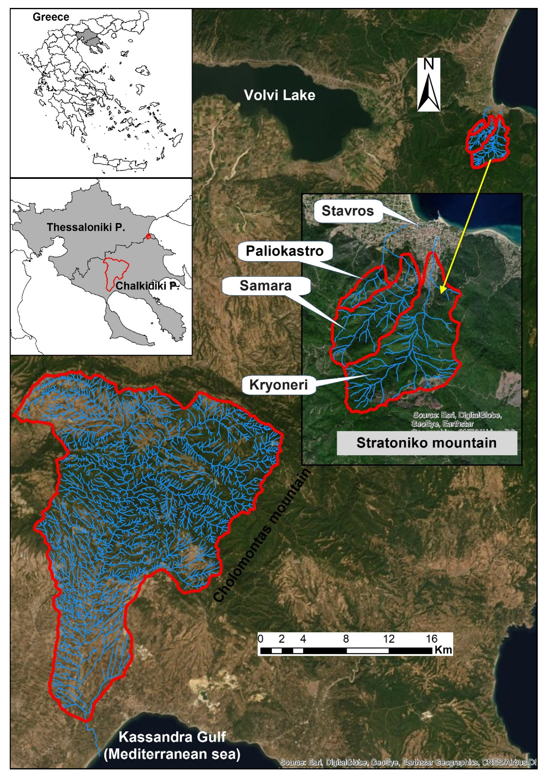
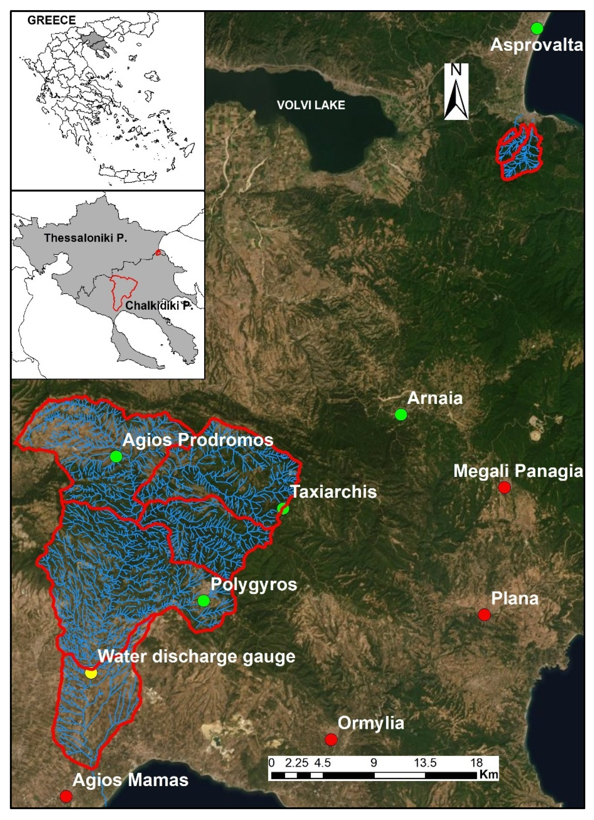
2.1. Watersheds Description
2.2. Floodplain Delineation
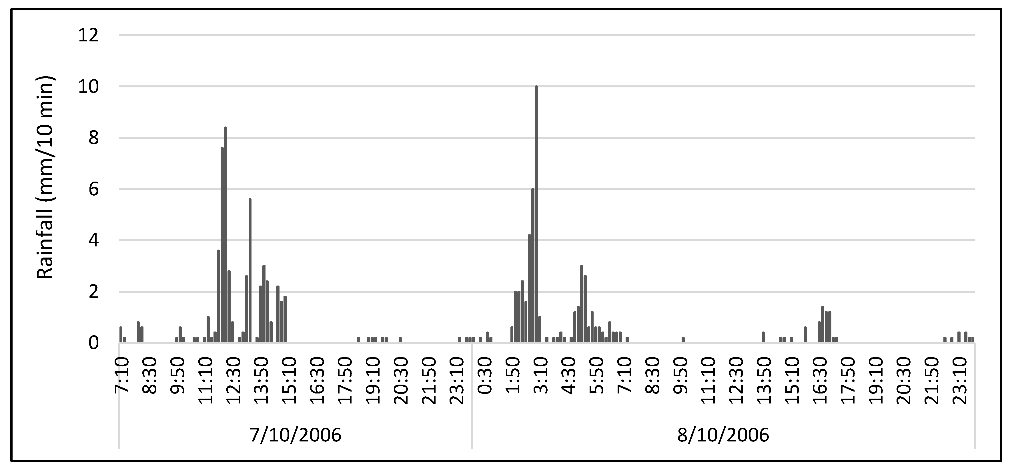
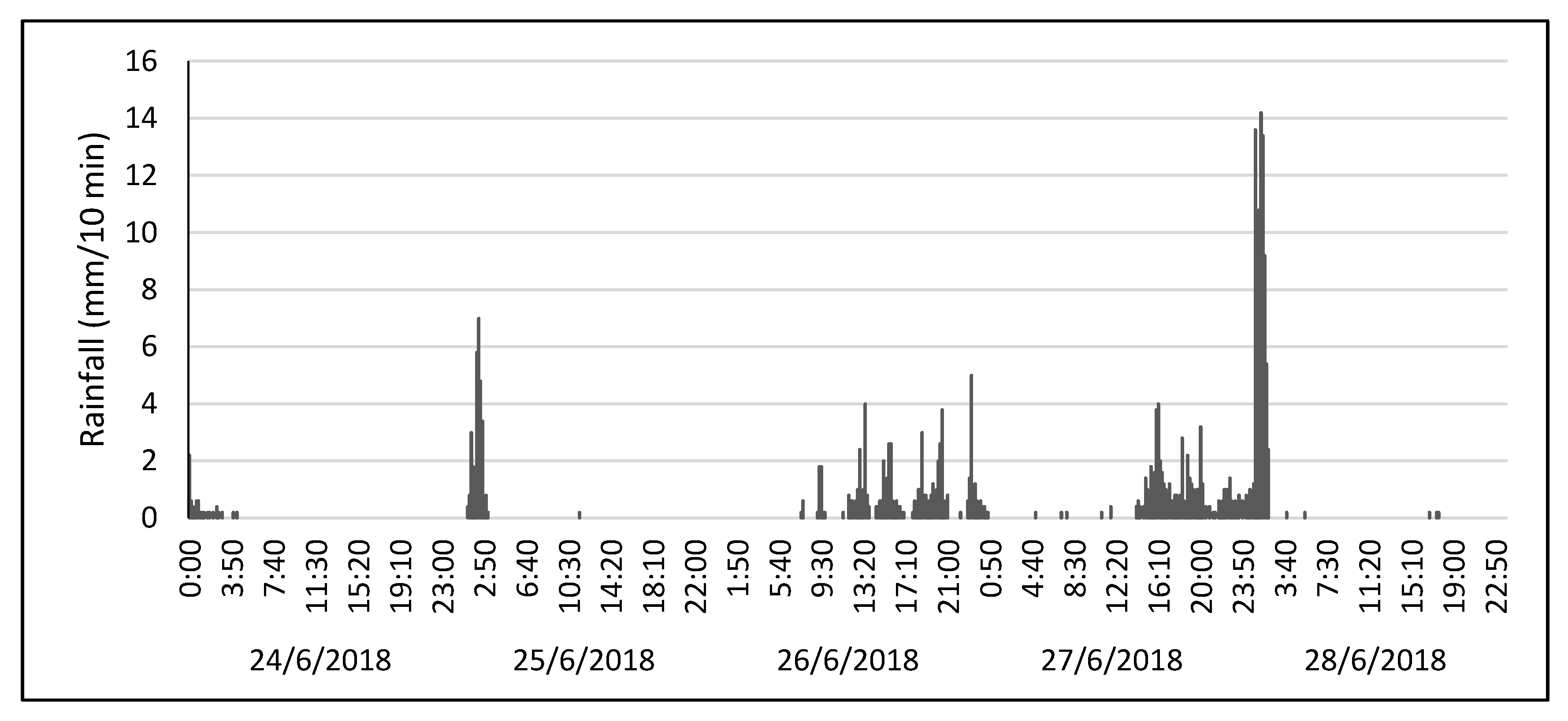
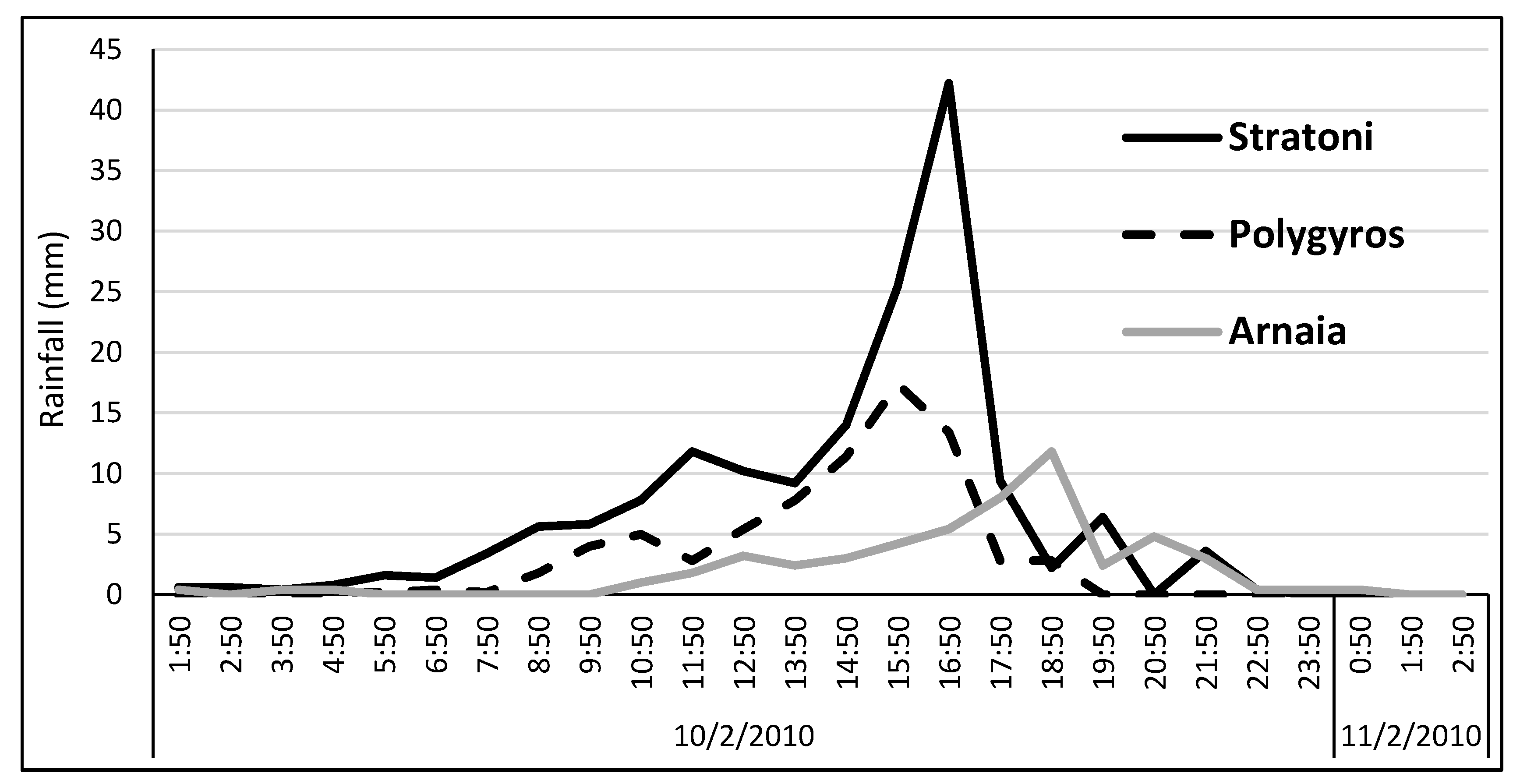
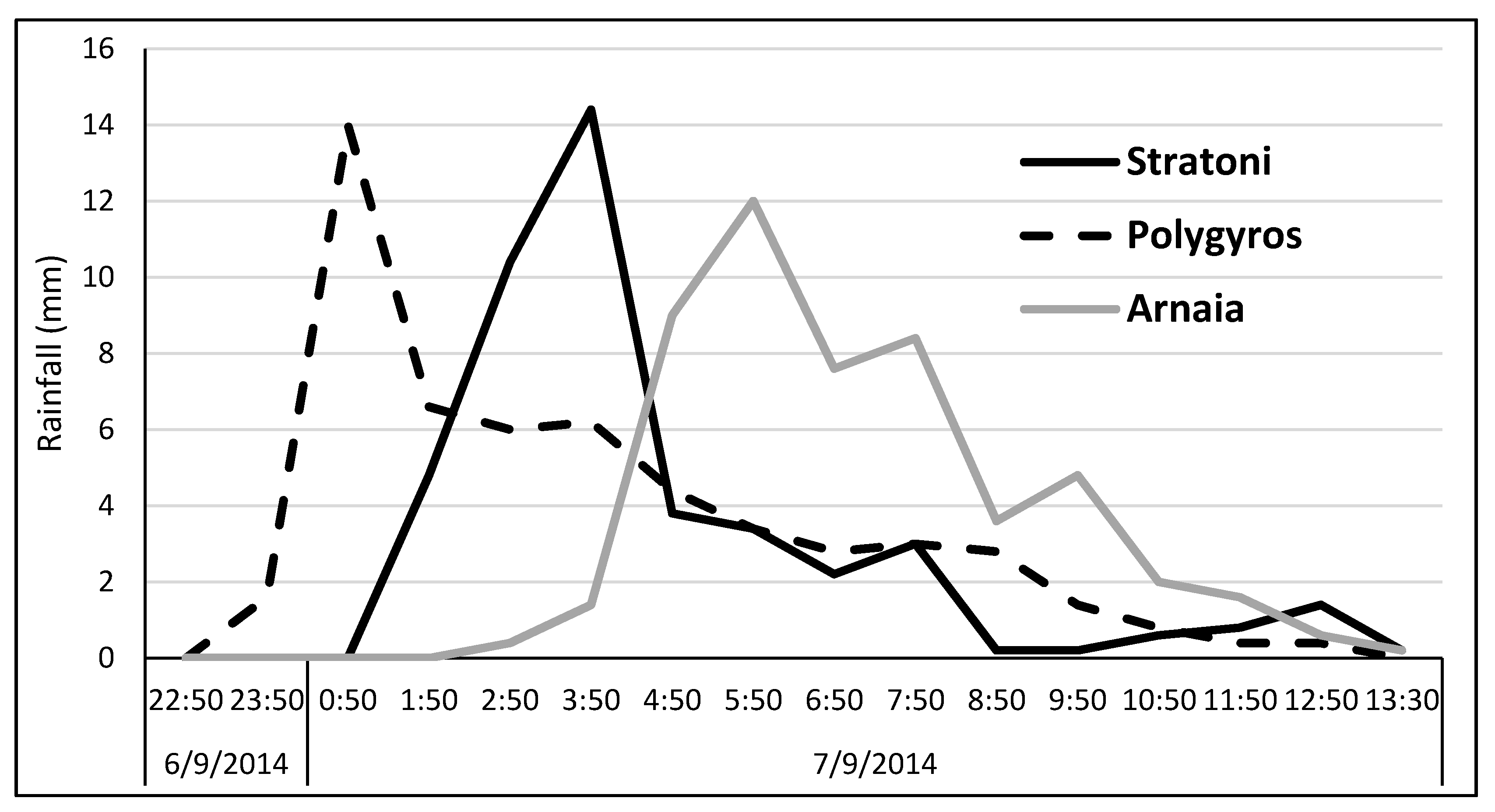
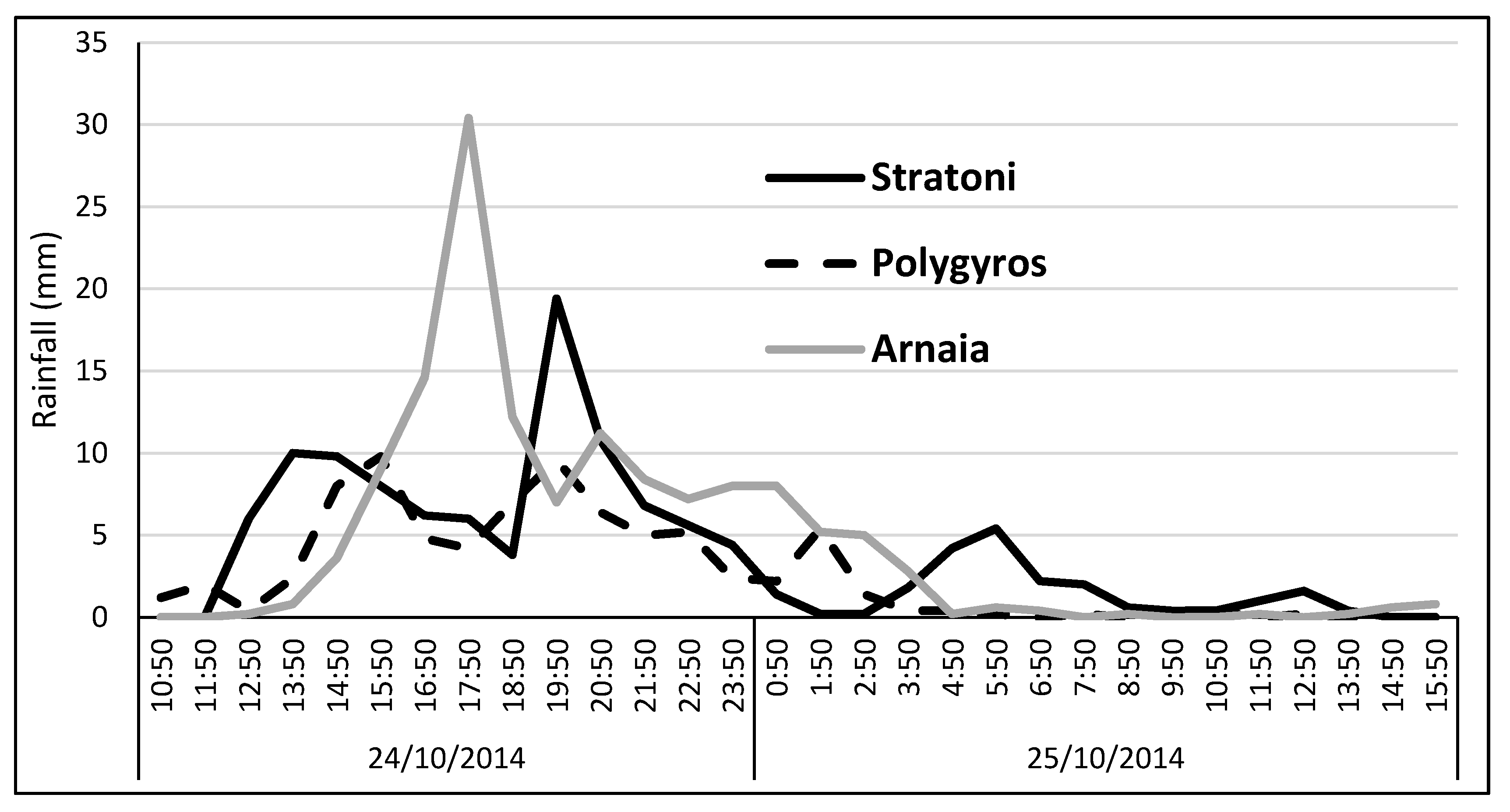
2.3. Flash Floods of October 2006, February 2010, and June 2018
2.4. Hydrological Modeling
2.5. Hydraulic Modeling
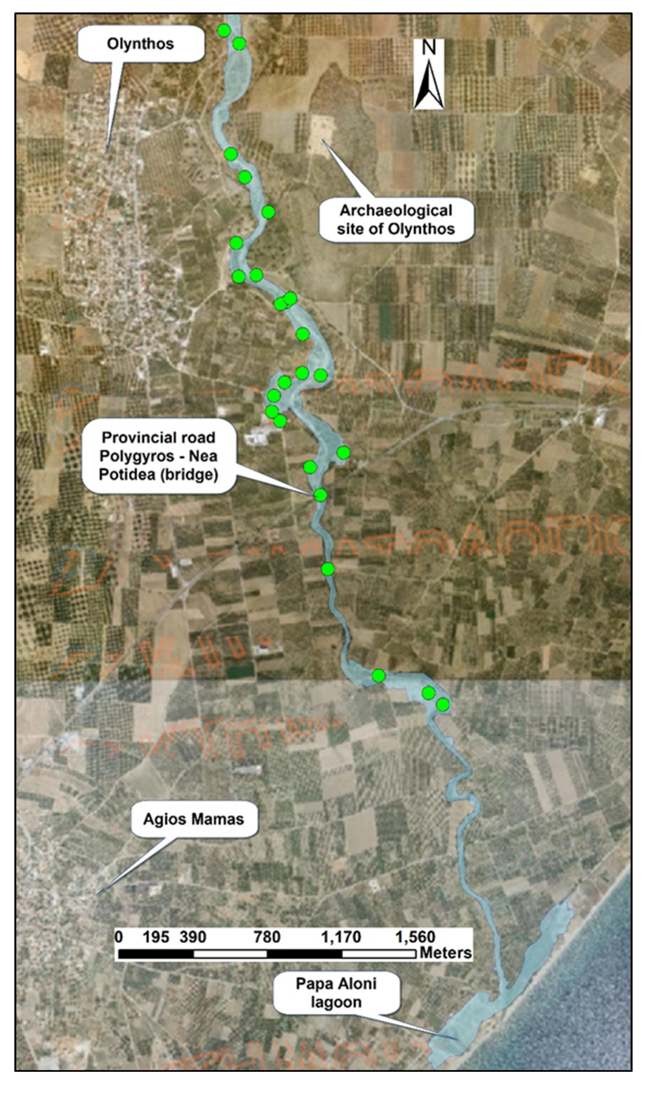
2.6. Post-Flood Measurements
3. Results
3.1. Hydrological Modeling
3.2. Hydraulic Modeling and Post-Flood Measurements
3.3. Critical Locations of Increased Flood Risk
3.4. Discusion on Flood Generation Causes
4. Conclusions
Author Contributions
Funding
Conflicts of Interest
References
- House, P.K.; Baker, V.R. Paleohydrology of flash floods in small desert watersheds in western Arizona. Water Resour. Res. 2001, 37, 1825–1839. [Google Scholar] [CrossRef]
- Dhar, N.O.; Nandargy, S. Hydrometeorological aspects of floods in India. Nat. Hazards 2003, 28, 1–33. [Google Scholar] [CrossRef]
- Yatheendradas, S.; Wagener, T.; Gupta, H.; Unkrich, C.; Goodrich, D.; Schaffner, M.; Stewart, A. Understanding uncertainty in distributed flash flood forecasting for semiarid regions. Water Resour. Res. 2008, 44, 44. [Google Scholar] [CrossRef]
- Barredo, J.I. Major flood disasters in Europe: 1950–2005. Nat. Hazards 2007, 42, 125–148. [Google Scholar] [CrossRef]
- Merz, B.; Kreibich, H.; Schwarze, R.; Thieken, A. Assessment of economic flood damage. Nat. Hazards Earth Syst. Sci. 2010, 10, 1679–1724. [Google Scholar] [CrossRef]
- Papagiannaki, K.; Lagouvardos, K.; Kotroni, B. A database of high-impact weather events in Greece: A descriptive impact analysis for the period 2001–2011. Nat. Hazards Earth Syst. Sci. 2013, 13, 727–736. [Google Scholar] [CrossRef]
- Diakakis, M.; Deligiannakis, G. Flood fatalities in Greece: 1970–2010. J. Flood Risk Manag. 2015, 10, 115–123. [Google Scholar] [CrossRef]
- Kundzewicz, W.; Kaczmare, Z. Coping with hydrological extremes. Water Int. 2000, 25, 66–75. [Google Scholar] [CrossRef]
- Ebert, A.; Kerle, N.; Stein, A. Urban social vulnerability assessment with physical proxies and spatial metrics derived from air and spaceborne imagery and GIS data. Nat. Hazards 2009, 48, 275–294. [Google Scholar] [CrossRef]
- Faccini, F.; Luino, F.; Paliaga, G.; Sacchini, A.; Turconi, L.; de Jong, C. Role of rainfall intensity and urban sprawl in the 2014 flash flood in Genoa City, Bisagno catchment (Liguria, Italy). Appl. Geogr. 2018, 98, 224–241. [Google Scholar] [CrossRef]
- Diakakis, M.; Andreadakis, E.; Nikolopoulos, E.I.; Spyrou, N.I.; Gogou, M.E.; Deligiannakis, G.; Katsetsiadou, N.K.; Antoniadis, Z.; Melaki, M.; Georgakopoulos, A.; et al. An integrated approach of ground and aerial observations in flash flood disaster investigations. The case of the 2017 Mandra flash flood in Greece. Int. J. Disaster Risk Reduct. 2019, 33, 290–309. [Google Scholar] [CrossRef]
- Sapountzis, M.; Stathis, D. Relationship between Rainfall and Run-off in the Stratoni Region (N. Greece) after the storm of 10th February 2010. Glob. NEST J. 2014, 16, 420–431. [Google Scholar]
- Segura-Beltrán, F.; Sanchis-Ibor, C.; Morales-Hernández, M.; González-Sanchis, M.; Bussi, G.; Ortiz, E. Using post-flood surveys and geomorphologic mapping to evaluate hydrological and hydraulic models: The flash flood of the Girona River (Spain) in 2007. J. Hydrol. 2016, 541, 310–329. [Google Scholar] [CrossRef]
- De Jong, C. European perspectives on forest hydrology. In Forest Hydrology: Processes, Management and Assessment; Amatya, D., Williams, T., Bren, L., De Jong, C., Eds.; CABI: Wallingford, UK, 2016; pp. 69–87. [Google Scholar]
- Hegg, C. Waldwirkung auf Hochwasser (Forest impacts on floods). LWF Wissen 2006, 55, 29–33. [Google Scholar]
- Pilgrim, D.H.; Chapman, T.G.; Doran, D.G. Problems of rainfall-runoffmodeling in arid and semiarid regions. Hydrol. Sci. J. 1988, 33, 379–400. [Google Scholar] [CrossRef]
- Smith, D.I. Flood damage estimation-a review of urban stage-damage curves and loss functions. Water SA 1994, 20, 231–238. [Google Scholar]
- Anselmo, V.; Galeati, G.; Palmieri, S.; Rossi, U.; Todini, E. Flood risk assessment using an integrated hydrological and hydraulic modeling approach: A case study. J. Hydrol. 1996, 175, 533–554. [Google Scholar] [CrossRef]
- Vélez, J.J.; Puricelli, M.; López Unzu, F.; Francés, F. Parameter extrapolation to ungauged basins with a hydrological distributed model in a regional framework. Hydrol. Earth Syst. Sci. 2009, 13, 229–246. [Google Scholar] [CrossRef]
- Braud, I.; Roux, H.; Anquetin, S.; Maubourguet, M.M.; Manus, C.; Viallet, P.; Dartus, D. The use of distributed hydrological models for the Gard 2002 flash flood event: Analysis of associated hydrological processes. J. Hydrol. 2010, 394, 162–181. [Google Scholar] [CrossRef]
- Booij, M.J. Impact of climate change on river flooding assessed with different spatial model resolutions. J. Hydrol. 2005, 303, 176–198. [Google Scholar] [CrossRef]
- Myronidis, D.; Emmanouloudis, D.; Stathis, D.; Stefanidis, P. Integrated flood hazard mapping in the framework of the E.U. directive on the assessment and management of flood risks. Fresenius Environ. Bull. 2009, 18, 102–111. [Google Scholar]
- Lacasta, A.; Morales-Hernández, M.; Murillo, J.; García-Navarro, P. An optimized GPU implementation of a 2D free surface simulation model on unstructured meshes. Adv. Eng. Softw. 2014, 78, 1–15. [Google Scholar] [CrossRef]
- Kastridis, A.; Stathis, D. The Effect of Rainfall Intensity on the Flood Generation of Mountainous Watersheds (Chalkidiki Prefecture, North Greece). In Perspectives on Atmospheric Sciences; Karacostas, T., Bais, A., Nastos, P., Eds.; Springer International Publishing: Cham, Switzerland, 2017; pp. 341–347. [Google Scholar] [CrossRef]
- Soil Conservation Service (SCS). National Engineering Handbook; Section 4; U.S. Department of Agriculture: Washington, DC, USA, 1972. [Google Scholar]
- Hydrologic Modeling System HEC—HMS; User’s Manual, Version 4.2; US Army Corps of Engineers, Hydrologic Engineering Center: Davis, CA, USA, 2016.
- HEC—RAS. River Analysis System; User’s Manual, Version 4.1; US Army Corps of Engineers, Hydrologic Engineering Center: Davis, CA, USA, 2010.
- HEC—GeoRAS. GIS Tools for Support of HEC—RAS Using ArcGIS; User’s Manual, Version 4.2; US Army Corps of Engineers, Hydrologic Engineering Center: Davis, CA, USA, 2009.
- Steenhuis, T.; Winchell, M.; Rossing, J.; Zollweg, J.A.; Walters, M. SCS runoff equation revisited for variable-source runoff areas. J. Irrig. Drain. Eng. ASCE 1995, 121, 234–238. [Google Scholar] [CrossRef]
- Van Dijk, A.I.J.M. Selection of an appropriately simple storm runoff model. Hydrol. Earth Syst. Sci. 2010, 14, 447–458. [Google Scholar] [CrossRef]
- Mitra, S.S.; Wright, J.; Abhisek, S.; Ghosh, A.R. An integrated water balance model for assessing water scarcity in a data-sparse interfluve in eastern India. Hydrol. Sci. J. 2015, 60, 1813–1827. [Google Scholar] [CrossRef][Green Version]
- Rezaei-Sadr, H. Influence of coarse soils with high hydraulic conductivity on the applicability of the SCS-CN method. Hydrol. Sci. J. 2017, 62, 843–848. [Google Scholar] [CrossRef]
- Verma, S.; Verma, R.K.; Mishra, S.K.; Singh, A.; Jayaraj, G.K. A revisit of NRCS-CN inspired models coupled with RS and GIS for runoff estimation. Hydrol. Sci. J. 2017, 62, 1891–1930. [Google Scholar] [CrossRef]
- Stathis, D.; Sapountzis, M.; Myronidis, D. Assessment of land use change effect on design storm hydrograph using the SCS curve number method. Fresenius Environ. Bull. 2010, 19, 1928–1934. [Google Scholar]
- Kastridis, A.; Stathis, D. Natural and Anthropogenic Flash Flood Generation in Mountainous Watersheds—The Case of Apollonia Torrent. In Proceedings of the Protection and Restoration of the Environment XI. Water Resources Management, Thessaloniki, Greece, 3–6 July 2012; pp. 126–135. [Google Scholar]
- Nalbantis, Ι.; Lymperopoulos, S. Assessment of flood frequency after forest fires in small ungauged basins based on uncertain measurements. Hydrol. Sci. J. 2012, 57, 52–72. [Google Scholar] [CrossRef]
- Kaffas, K.; Hrissanthou, V. Application of a continuous rainfall-runoff model to the basin of Kosynthos river using the hydrologic software HEC-HMS. Glob. NEST J. 2014, 16, 188–203. [Google Scholar]
- Kastridis, A.; Kamperidou, V. Evaluation of the post-fire erosion and flood control works in the area of Cassandra (Chalkidiki, North Greece). J. For. Res. 2015, 26, 209–217. [Google Scholar] [CrossRef]
- Yannopoulos, S.; Eleftheriadou, E.; Mpouri, S.; Giannopoulou, I. Implementing the Requirements of the European Flood Directive: The Case of Ungauged and Poorly Gauged Watersheds. Environ. Process. 2015, 2, 191–207. [Google Scholar] [CrossRef]
- Soulis, K.X.; Valiantzas, J.D.; Dercas, N.; Londra, P.A. Analysis of the runoff generation mechanism for the investigation of the SCS-CN method applicability to a partial area experimental watershed. Hydrol. Earth Syst. Sci. 2009, 13, 605–615. [Google Scholar] [CrossRef]
- Soulis, K.X.; Ntoulas, N.; Nektarios, P.; Kargas, G. Runoff reduction from extensive green roofs having different substrate depth and plant cover. Ecol. Eng. 2017, 102, 80–89. [Google Scholar] [CrossRef]
- Soulis, K. Estimation of SCS Curve Number variation following forest fires. Hydrol. Sci. J. 2018, 63, 1332–1346. [Google Scholar] [CrossRef]
- Papaioannou, G.; Efstratiadis, A.; Vasiliades, L.; Loukas, A.; Papalexiou, S.M.; Koukouvinos, A.; Tsoukalas, I.; Kossieris, P. An Operational Method for Flood Directive Implementation in Ungauged Urban Areas. Hydrology 2018, 5, 24. [Google Scholar] [CrossRef]
- USDA, United States Department of Agriculture. Urban Hydrology for Small Watersheds, Technical Release 55 (TR-55), 2nd ed.; Natural Resources, Conservation Service, Conservation Engineering Division: Washington, DC, USA, 1986. [Google Scholar]
- Efstratiadis, A.; Koutsoyiannis, D.; Mamassis, N.; Dimitriadis, P.; Maheras, A. Literature Review of Flood Hydrology and Related Tools, DEUCALION—Assessment of Flood Flows in Greece under Conditions of Hydroclimatic Variability: Development of Physically-Established Conceptual-Probabilistic Framework and Computational Tools. Available online: https://www.itia.ntua.gr/getfile/1215/1/documents/Report_WP3_1_1.pdf (accessed on 13 November 2019).
- Chow, V.T.; Maidment, D.R.; Mays, L.W. Applied Hydrology; McGraw-Hill: New York, NY, USA, 1988; p. 572. ISBN 0 07-010810-2. [Google Scholar]
- CORINE Land Cover. European Environment Agency (EEA) 2012. Available online: https://land.copernicus.eu/pan-european/corine-land-cover/clc-2012 (accessed on 22 October 2019).
- Arhonditsis, G.; Giourga, C.; Loumou, A.; Koulouri, M. Quantitative Assessment of Agricultural Runoff and Soil Erosion Using Mathematical Modeling: Applications in the Mediterranean Region. Environ. Manag. 2002, 30, 434–453. [Google Scholar] [CrossRef]
- Romero, P.; Castro, G.; Gómez, J.A.; Fereres, E. Curve Number Values for Olive Orchards under Different Soil Management. Soil Sci. Soc. Am. J. 2007, 71, 1758–1769. [Google Scholar] [CrossRef]
- Mitsopoulos, I.D.; Mironidis, D. Assessment of Post Fire Debris Flow Potential in a Mediterranean Type Ecosystem. In Proceedings of the First International Conference on Monitoring, Simulation, Prevention and Remediation of Dense and Debris Flows, Rhodes, Greece, June 7–9 2006; pp. 221–229. [Google Scholar] [CrossRef]
- Ioannou, K.; Myronidis, D.; Lefakis, P.; Stathis, D. The use of Artificial Neural Networks (ANNs) for the forecast of precipitation levels of Lake Doirani (N. Greece). Fresenius Environ. Bull. 2010, 19, 1921–1927. [Google Scholar]
- Socolofsky, S.A.; Adams, E.E.; Entekhabi, D. Disaggregation of daily rainfall for continuous watershed modeling. J. Hydrol. Eng. 2001, 6, 300–309. [Google Scholar] [CrossRef]
- Choi, J.; Socolofsky, S.A.; Olivera, F. Hourly Disaggregation of Daily Rainfall in Texas Using Measured Hourly Precipitation at Other Locations. J. Hydrol. Eng. 2008, 13, 476–487. [Google Scholar] [CrossRef]
- Ministry of Environment, Planning and Public Works of Greece. Drainage of Hydraulic Road Works. In Guidelines for the Study of Road Works; General Secretariat for Public Works, Directorate of Road Constructions: Athens, Greece, 2002. [Google Scholar]
- Koenig, T.A.; Bruce, J.L.; O’Connor, J.E.; McGee, B.D.; Holmes, R.R., Jr.; Hollins, R.; Forbes, B.T.; Kohn, M.S.; Schellekens, M.; Martin, Z.W.; et al. Identifying and preserving high-water mark data: U.S. Geol. Surv. Tech. Methods 2016, 3, 47. [Google Scholar]
- Altenau, E.H.; Pavelsky, T.M.; Bates, P.D.; Neal, J.C. The effects of spatial resolution and dimensionality on modeling regional scale hydraulics in a multichannel river. Water Resour. Res. 2017, 53, 1683–1701. [Google Scholar] [CrossRef]
- Bates, P.D.; De Roo, A. A simple raster-based model for flood inundation simulation. J. Hydrol. 2000, 236, 54–77. [Google Scholar] [CrossRef]
- Giandotti, M. Previsione delle piene e delle magre dei corsi d’acqua. Ministero LL.PP. In Memorie e Studi Idrografici; Servizio Idrografico Italiano: Rome, Italy, 1934; p. 13. (In Italian) [Google Scholar]
- Jodar-Abellan, A.; Valdes-Abellan, J.; Pla, C.; Gomariz-Castillo, F. Impact of land use changes on flash flood prediction using a sub-daily SWAT model in five Mediterranean ungauged watersheds (SE Spain). Sci. Total Environ. 2019, 657, 1578–1591. [Google Scholar] [CrossRef] [PubMed]
- Schleppi, P. Forested water catchments in a changing environment. In Forest Management and the Water Cycle: An Ecosystem-Based Approach; Bredemeier, M., Cohen, S., Godbold, D.L., Lode, E., Pichler, V., Schleppi, P., Eds.; Ecological Studies; Springer: New York, NY, USA, 2011; Volume 212, pp. 89–110. [Google Scholar]
- Stathis, D.; Stefanidis, P. Analysis of the Conditions of Flood Formation in Torrents in Area of North Chalkidiki (Greece) in October 2000. In Proceedings of the Conference: Third Balkan Scientific Conference, Study, Conservation and Utilization of Forest Resources, Sofia, Bulgaria, 2–6 October 2001; Volume 3, pp. 213–222. [Google Scholar]
- Stefanidis, P.; Kalinderis, I.; Tziaftani, F. The Cause and the Mechanism of the 7–8 October 2006 Flood at Olympiada Chalkidiki (north Greece). In Proceedings of the International Conference Erosion and Torrent Control as a Factor in Sustainable River Basin Management, Belgrade, Serbia, 25–28 September 2007. [Google Scholar]
- Myronidis, D.; Ioannou, K. Forecasting the Urban Expansion Effects on the Design Storm Hydrograph and Sediment Yield Using Artificial Neural Networks. Water 2019, 11, 31. [Google Scholar] [CrossRef]

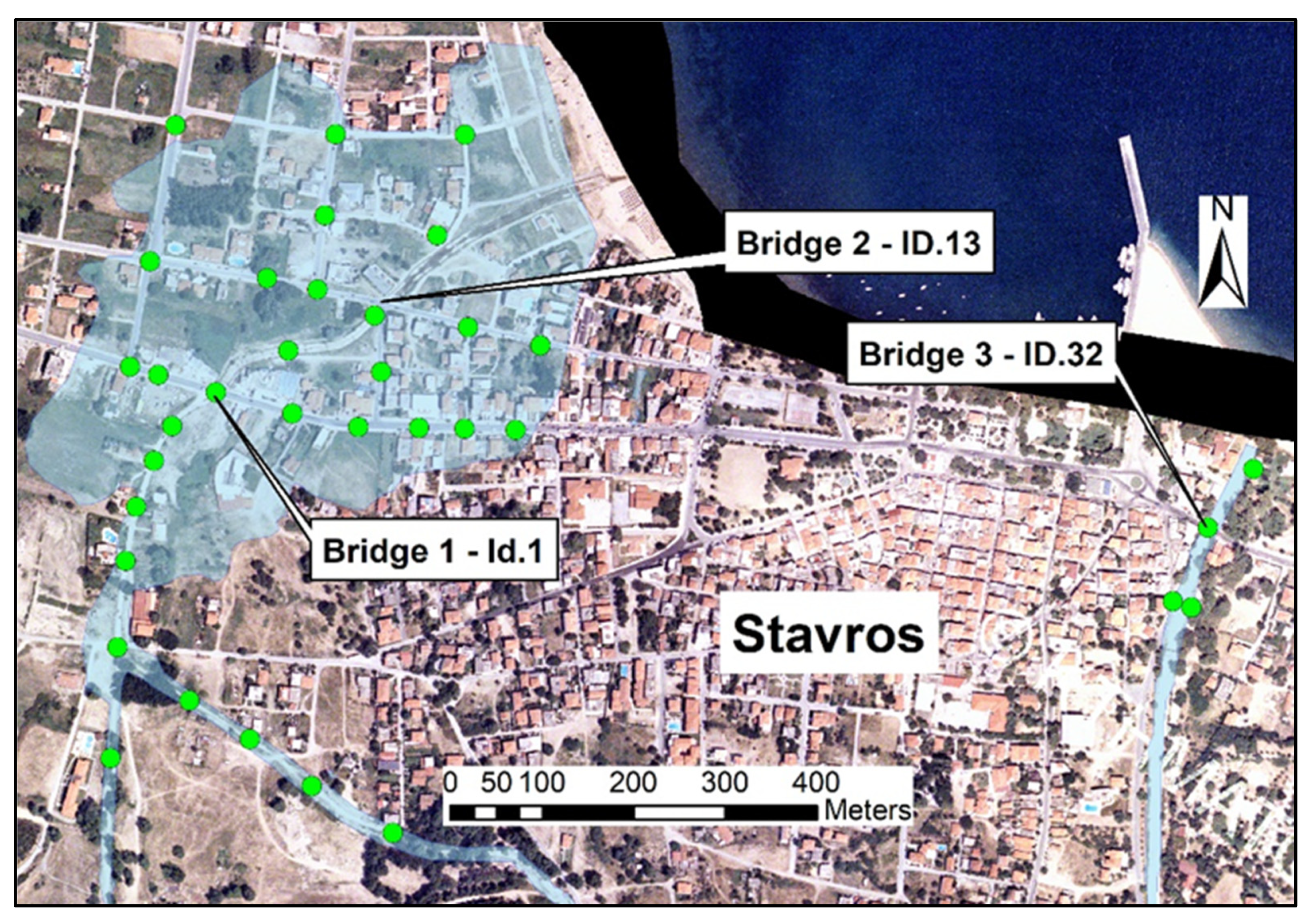
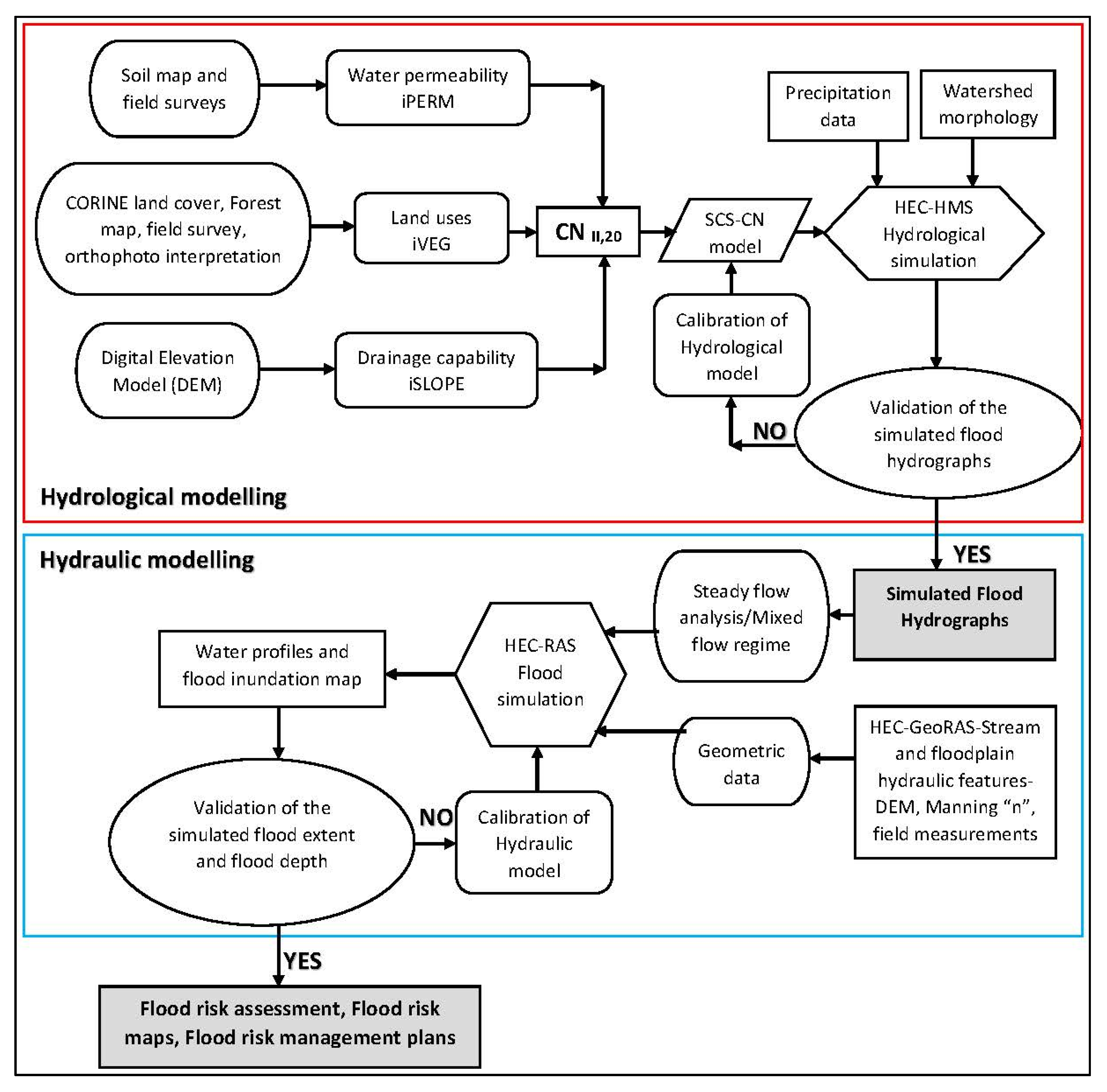
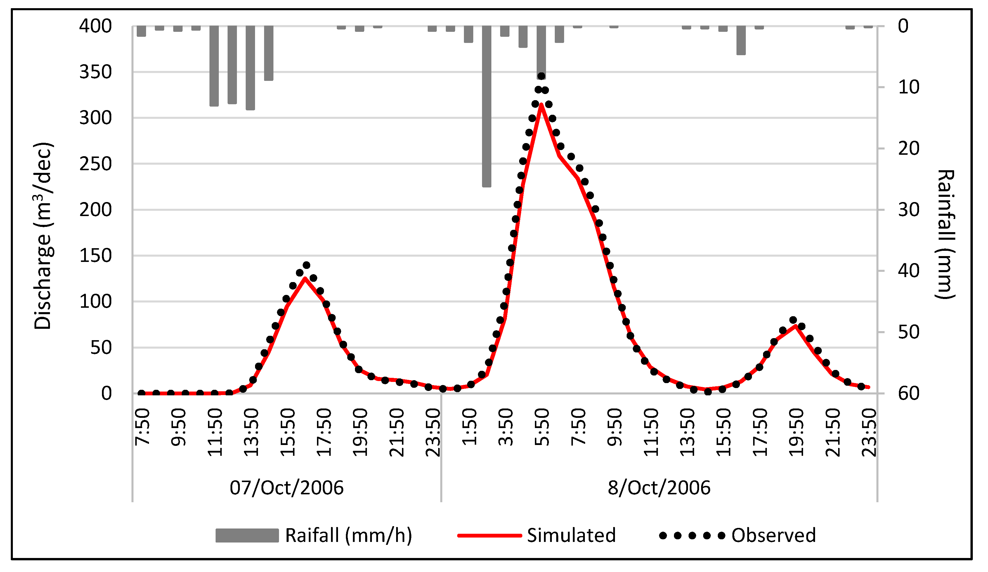
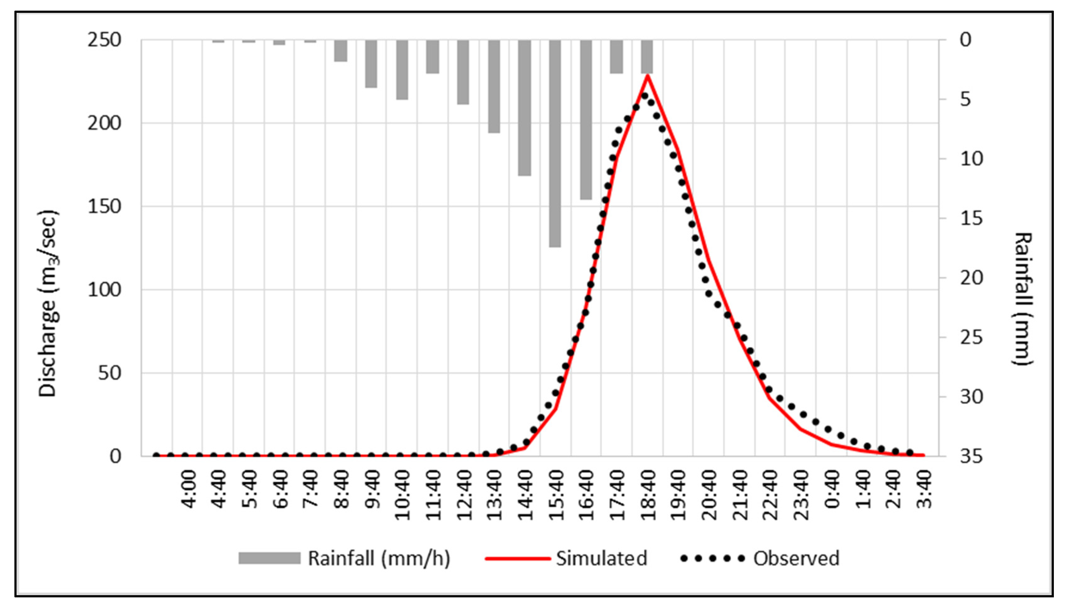

| Water Permeability | iPERM | Vegetation Density | iVEG | Drainage Capability | iSLOPE |
|---|---|---|---|---|---|
| Very high | 1 | Very dense | 1 | Negligible | 1 |
| High | 2 | Dense | 2 | Low | 2 |
| Medium | 3 | Sparse | 3 | Medium | 3 |
| Low | 4 | Very sparse | 4 | High | 4 |
| Very low | 5 | No vegetation | 5 | Very high | 5 |
| AMC Group | Total 5-day Antecedent Rainfall (mm) | |
|---|---|---|
| Dormant Season | Growing Season | |
| I | Less than 13 | Less than 35 |
| II | 13 to 28 | 35 to 53 |
| III | Over 28 | Over 53 |
| Water Permeability (iPERM) | Soil Characteristics | Geological or Hydro-Lithological Characteristics | Structural Characteristics |
|---|---|---|---|
| Very High (1) | Very light and well drained soils | Highly karstic carbonates, extensively developed, fragmented limestones, dolomites, marbles | ------- |
| High (2) | Sandy and gravelly soils with a low content of sludge and clay | River deposits, non-coherent conglomerates, Triassic breccias | Very small settlements |
| Medium (3) | Sandy thick soils, sludges and silty soils, sandy clay | Granular sediments, schists, cohesive sandstones, slate or fine-grained limestones in alternations with schist formations | Sparsely built areas, significant garden development, urban parks |
| Low (4) | Fine clay soils, clay soils, soils poor in organic materials | Flysch, metamorphic, plutonic and volcanic rocks, alternations of sands, marls, clays, conglomerates, marl limestones, sandstones, molassic deposits | Discontinuous urban fabric with small gardens |
| Very Low (5) | Shallow soils that swell when are wet, clays | Impermeable solid rocks (granite) | Shopping centers, areas with dense building construction |
| Vegetation Classes (iVEG) | Land Cover Characteristics |
|---|---|
| Very Dense(1) | Forests (coniferous, broad-leaved, mixed) |
| Dense(2) | Transitional woodland-shrubs, orchards, olive groves, riparian vegetation |
| Sparse(3) | Pastures, crops, vineyards, grasslands, shrubs |
| Very Sparse(4) | Sparsely vegetated areas, non-irrigated arable land, dunes, wetlands, discontinuous urban fabric |
| No vegetation(5) | Bare or rocky terrain, artificial surfaces (roads, buildings) |
| Drainage Capacity (iSLOPE) | Mean Slope (%) | Other Characteristics |
|---|---|---|
| Negligible(1) | 0% | Inadequate drainage system, frequent and extensive floods, unformed hydrographic network |
| Low(2) | 1–2% | Significant floodplain areas, occasional floods, poorly formed hydrographic network |
| Medium(3) | 2–10% | Small floodplain areas, rare floods, shallow, low depth hydrographic network |
| High(4) | 10–30% | Insignificant floodplain areas, well-formed hydrographic network, existence of artificial drainage network |
| Very High(5) | 30% | Mountainous relief |
| Id | Street Name | Flood Depth (m) | X | Y |
|---|---|---|---|---|
| 1 | Unnamed rural road | 0 | 23.348287 | 40.301443 |
| 2 | Unnamed rural road | 2.9 | 23.349236 | 40.300835 |
| 3 | Archaeological Site of Olynthos | 1.75 | 23.352248 | 40.2886 |
| 4 | Archaeological Site of Olynthos | 0.45 | 23.351907 | 40.288491 |
| 5 | Archaeological Site of Olynthos | 0.25 | 23.352511 | 40.288757 |
| 6 | Unnamed rural road | 0.85 | 23.351544 | 40.284139 |
| 7 | Unnamed rural road | 0 | 23.351928 | 40.282949 |
| 8 | Unnamed rural road | 2.55 | 23.348772 | 40.295589 |
| 9 | Unnamed rural road | 0.1 | 23.353276 | 40.285221 |
| 10 | Unnamed rural road | 0.55 | 23.351426 | 40.283387 |
| 11 | Unnamed rural road | 0.7 | 23.355864 | 40.281469 |
| 12 | Unnamed rural road | 3.65 | 23.354952 | 40.275934 |
| 13 | Unnamed rural road | 4.1 | 23.358143 | 40.270898 |
| 14 | Provincial road Polygyros: Nea Potidea (bridge) | 3.95 | 23.354452 | 40.279435 |
| 15 | Unnamed rural road | 0.9 | 23.353801 | 40.280767 |
| 16 | Unnamed rural road | 0.5 | 23.35329 | 40.287081 |
| 17 | Unnamed rural road | 0.75 | 23.350384 | 40.289853 |
| 18 | Unnamed rural road | 0.4 | 23.349308 | 40.289774 |
| 19 | Unnamed rural road | 0.5 | 23.352191 | 40.284774 |
| 20 | Unnamed rural road | 0.8 | 23.361231 | 40.270093 |
| 21 | Unnamed rural road | 0.6 | 23.362123 | 40.26955 |
| 22 | Olynthos football field | 0.3 | 23.34914 | 40.291372 |
| 23 | Olynthos football field | 0.45 | 23.349639 | 40.294497 |
| 24 | Olynthos football field | 0.25 | 23.351097 | 40.292848 |
| 25 | Unnamed rural road | 0.95 | 23.354423 | 40.285123 |
| Id | Street Name | Flood Depth (m) | X | Y |
|---|---|---|---|---|
| 1 | Georgios Papandreou: Bridge 1, west stream | 1.55 | 23.689867 | 40.665598 |
| 2 | Ellispondou, west main stream | 1.5 | 23.689303 | 40.665266 |
| 3 | Ellispondou, west main stream | 1.5 | 23.688841 | 40.664469 |
| 4 | Ellispondou, west main stream | 1.5 | 23.689069 | 40.664923 |
| 5 | Ellispondou, west main stream | 1.5 | 23.688709 | 40.663935 |
| 6 | Ellispondou, west main stream | 1.5 | 23.688604 | 40.663083 |
| 7 | Samara main stream | 1.75 | 23.689537 | 40.662564 |
| 8 | Samara main stream | 1.75 | 23.690318 | 40.662182 |
| 9 | Samara main stream | 1.75 | 23.691122 | 40.661726 |
| 10 | Samara main stream | 1.75 | 23.692173 | 40.661267 |
| 11 | Paliokastro main stream | 1.6 | 23.688521 | 40.661993 |
| 12 | West main stream | 1.6 | 23.690801 | 40.66601 |
| 13 | Panagouli: Bridge 2, west stream | 1.55 | 23.691914 | 40.666361 |
| 14 | Panagouli | 0.5 | 23.691174 | 40.666614 |
| 15 | Georgios Papandreou | 0.2 | 23.692495 | 40.665254 |
| 16 | Georgios Papandreou | 0.25 | 23.691706 | 40.665261 |
| 17 | Georgios Papandreou | 0.3 | 23.690854 | 40.665392 |
| 18 | Georgios Papandreou | 0.2 | 23.693084 | 40.665251 |
| 19 | Aristoteli | 0.6 | 23.692719 | 40.667151 |
| 20 | Panagouli | 0.3 | 23.693124 | 40.666246 |
| 21 | Georgios Papandreou | 0.25 | 23.689119 | 40.665768 |
| 22 | Panagouli | 0.5 | 23.690523 | 40.666723 |
| 23 | Georgios Papandreou | 0.2 | 23.688755 | 40.665848 |
| 24 | Panagouli | 0.15 | 23.689009 | 40.666886 |
| 25 | Aristoteli | 0.2 | 23.691405 | 40.668144 |
| 26 | Aristoteli | 0.6 | 23.691268 | 40.667345 |
| 27 | Kosti Palama | 0.55 | 23.693072 | 40.668142 |
| 28 | Panagouli | 0.15 | 23.69406 | 40.666071 |
| 29 | Lambraki | 0.4 | 23.692003 | 40.665803 |
| 30 | Georgios Papandreou | 0.2 | 23.693743 | 40.665236 |
| 31 | Andreas Papandreou | 0 | 23.689331 | 40.668227 |
| 32 | Paleologou: Bridge 3, Kryoneri stream | 1.55 | 23.702699 | 40.664298 |
| 33 | Xrysostomou Smyrnis, Kryoneri stream | 0 | 23.702489 | 40.663516 |
| 34 | Xrysostomou Smyrnis, Kryoneri stream | 0 | 23.702246 | 40.663572 |
| 35 | Kryoneri stream, near the coast line | 0 | 23.703285 | 40.664876 |
© 2020 by the authors. Licensee MDPI, Basel, Switzerland. This article is an open access article distributed under the terms and conditions of the Creative Commons Attribution (CC BY) license (http://creativecommons.org/licenses/by/4.0/).
Share and Cite
Kastridis, A.; Stathis, D. Evaluation of Hydrological and Hydraulic Models Applied in Typical Mediterranean Ungauged Watersheds Using Post-Flash-Flood Measurements. Hydrology 2020, 7, 12. https://doi.org/10.3390/hydrology7010012
Kastridis A, Stathis D. Evaluation of Hydrological and Hydraulic Models Applied in Typical Mediterranean Ungauged Watersheds Using Post-Flash-Flood Measurements. Hydrology. 2020; 7(1):12. https://doi.org/10.3390/hydrology7010012
Chicago/Turabian StyleKastridis, Aristeidis, and Dimitrios Stathis. 2020. "Evaluation of Hydrological and Hydraulic Models Applied in Typical Mediterranean Ungauged Watersheds Using Post-Flash-Flood Measurements" Hydrology 7, no. 1: 12. https://doi.org/10.3390/hydrology7010012
APA StyleKastridis, A., & Stathis, D. (2020). Evaluation of Hydrological and Hydraulic Models Applied in Typical Mediterranean Ungauged Watersheds Using Post-Flash-Flood Measurements. Hydrology, 7(1), 12. https://doi.org/10.3390/hydrology7010012


