Article

Hydrological Evaluation of Satellite and Reanalysis Precipitation Products in the Upper Blue Nile Basin: A Case Study of Gilgel Abbay

by
Haileyesus Belay Lakew
*,
Semu Ayalew Moges
and
Dereje Hailu Asfaw
School of Civil and Environmental Engineering, Addis Ababa University Institute of Technology, P.O. Box 385 Addis Ababa, Ethiopia
*
Author to whom correspondence should be addressed.
Hydrology 2017, 4(3), 39; https://doi.org/10.3390/hydrology4030039
Submission received: 17 July 2017 / Revised: 14 August 2017 / Accepted: 14 August 2017 / Published: 15 August 2017

Abstract

:
The aim of this study is to assess the performance of various global precipitation products for water resources application in the Upper Blue Nile basin, Ethiopia. Three precipitation products of gauge-adjusted (corrected) CMORPH, (TRMM) TMPA 3B42v7 and ECMWF reanalysis products are evaluated. A Coupled Routing and Excess Storage (CREST) distributed hydrological model is calibrated and used for the evaluation. The model is calibrated for 2000–2005 and validated for 2006–2011 periods using daily observed rainfall and discharge datasets. The results indicate the precipitation products consistently provide a better performance of runoff estimation when they are independently calibrated than simulation modes of the products. We conclude as long as each product is calibrated independently, global precipitation products can provide enough information for water resource management in data-scarce regions of upper Blue Nile Basin. Further analysis is underway to understand the response characteristics of the precipitation products at larger spatio-temporal scales.

1. Introduction

Water resource applications in regions without good quality and reliable temporal rainfall data are complicated by a lack of adequate spatial coverage. For example, in many African countries, the spatial coverage of hydrometeorological stations is very low. An African Climate Policy center (ACPC) assessment report [1] indicates while the spatial coverage of African climate stations is in the order of 1 station per 27,347 km2, it is 1 station per 1244 km2 in Germany. Similarly, the coverage of the stream flow stations in Africa is very low. There are 888 gauging stations in Africa in an area of 21,300,000 km2 (without including the area of the Sahara), while there are 1150 streamflow gauges per 357,114 km2 area in Germany. The situation in Ethiopia and upper Blue Nile is not different from this global picture. This contrasting revelation indicates the importance of supplementing the continent’s hydro-information system with remotely sensed satellite and reanalysis products. Therefore, high-resolution precipitation products have major role in hydrological analysis and water resource application in such data-limited regions.
High-resolution satellite products have their own errors in reproducing streamflow hydrographs. It is well known that satellite rainfall values are estimates that are subject to a variety of error sources (e.g., gaps in revisit times, poor direct relationship between remotely sensed signals and rainfall rate, and atmospheric effects that modify the radiation field) and require a thorough validation [2,3,4]. According to [2,3], validation efforts can be grouped into two categories. The first is the direct comparison of the satellite rainfall estimates to the rain gauge networks and ground-based radar estimates. The second is the evaluation of satellite rainfall estimates based on their predictive ability of streamflow rate in a hydrological modeling framework. The second evaluation approach has two advantages. One, since the evaluation is performed at the watershed scale, it is not subject to the scale discrepancy problem that arises when using rain gauge data for validation. Two, the satellite rainfall estimates are evaluated with respect to a specific application, such as a driving input variable in a hydrologic model. Consequently, [2,3,4] evaluated each of the satellite products calibrated independently as input to hydrological models.
Bitew and Gebremichael [4] assessed four high resolution satellite precipitation products in the Upper Blue Nile basin, Gilgel Abbay watershed: Climate Prediction Center’s morphing technique (CMORPH), Tropical Rainfall Measuring Mission (TRMM) Multi-satellite Precipitation Analysis (TMPA) method near real-time (3B42RT) product (TMPA 3B42RT),TMPA method post-real-time research version (3B42) product (TMPA 3B42) and Precipitation Estimation from Remotely Sensed Information using Artificial Neural Networks (PERSIANN); the study investigated the application of satellite precipitation products using the semi-distributed Soil and Water Assessment Tool (SWAT) hydrological model for a short period. They calibrated (2003–2004) and verified (2006–2007) the model independently with respect to each precipitation product. The result reveals that the 3B42RT and CMORPH simulations show consistent and modest performances in their simulations but underestimate the large flood peaks, while the 3B42 and PERSIANN simulations have inconsistent performance with poor or no skills. They also concluded the satellite-only product (3B42RT) performs much better than the satellite-gauge product (3B42), indicating that the algorithm used to incorporate rain gauge information with the goal of improving the accuracy of the satellite rainfall products is actually making the products worse, pointing to problems in the algorithm. However, CMORPH and 3B42 satellite precipitation products show consistent and modest skills in their simulation in terms of volume and statistical performance for Gilgel Abbay watershed in the Upper Blue Nile basin. Habib et al., 2014 [5] also showed improvements of the bias-corrected CMORPH satellite data in the hydrological performance of Gilgel Abbay (1656 km2) watershed compared to the uncorrected CMORPH product using the semi distributed Hydrologiska Byråns Vattenbalansavdelning (HBV) hydrological model for the years of 2003 and 2004. However, the uncorrected CMORPH shows modest performance based on the Nash-Sutcliffe coefficient of efficiency (NSCE) and relatively high bias values. These findings indicate many of the evaluations of the effects of satellite products on hydrological performance were tested by independently calibrating the models to each satellite product. Secondly, the different products indicated poor to modest skill for short calibration and validation periods at Gilgel Abbay watershed by applying semi distributed hydrological models.
This research aims to evaluate the performance of various satellite and reanalysis global precipitation datasets for water resource application in the Upper Blue Nile basin, Ethiopia, using the Coupled Routing and Excess Storage (CREST) fully distributed hydrological model for multi-year and recent observed data from 2000 to 2011. Three precipitation products of gauge-adjusted CMORPH, (TRMM) TMPA 3B42v7 and the newly released ECMWF (Reanalysis) are used to validate the performance of the products in reproducing the flow hydrograph for three different calibration and simulation conditions (modes).

2. Materials and Methods

2.1. Study Area

Gilgel Abbay watershed, which has a drainage area of 1656 km2, is located in Blue Nile Basin, in the Ethiopian part of the East Africa highlands between 36°48′ E–37°24′ E and 10°56′ N–11°23′ N (Figure 1). The landscape has complex topography with elevation ranging between 1901–3336m, and the climate is semi-humid with mean annual rainfall of 1300mm. The land is covered by cropland (55%), forest and shrub (25%), and pasture (20%). Soils are dominantly fine textured: clay (42%), clay loam (39%), and sandy loam and silt (19%).

2.2. Hydrometeorological Data Sets

In this study, three types of global precipitation datasets, with daily temporal scale (not aggregated) have been taken as inputs: the high resolution (0.25 × 0.25°) gauge-adjusted (corrected) satellite precipitation datasets of CMORPH, TRMM (TMPA 3B42v7) and (0.5 × 0.5°) reanalysis forcing precipitation product of European Centre for Medium range Weather Forecasts (ECMWF). Station (gauge)-based daily measured rainfall and streamflow historical data (2000–2011) have been taken as inputs to setup the grid-based hydrological model (CREST). Grid-based daily temporal scale of Potential Evapotranspiration (PET, mm/day) data (0.5 × 0.5°) and reanalysis forcing precipitation ECMWF (daily, 0.5 × 0.5°) data are accessed from the eartH2Observe Data portal (https://wci.earth2observe.eu/portal/). CMORPH products are derived using the morphing technique that uses precipitation estimates derived from passive microwave observations and propagates these features in space using motion vectors derived from half-hourly geostationary satellite infrared data [6]. The TMPA (3B42v7) method uses microwave (MW) data to calibrate the infrared (IR)-derived estimates and creates estimates that contain MW-derived rainfall estimates when and where MW data are available, and calibrated IR estimates where MW data are not available [7]. A climate reanalysis gives a numerical description of the recent climate, produced by combining models with observations. It contains estimates of atmospheric parameters such as air temperature, pressure and wind at different altitudes, and surface parameters such as rainfall, soil moisture content, and sea-surface temperature. ECMWF is one of the outputs of forcing reanalysis version-1 global precipitation data [8] (http://www.ecmwf.int/en/research/climate-reanalysis/era-20c). The grid-based (0.5 × 0.5°) reference potential evapotranspiration (PET) that is derived from the Penman-Monteith method has been used as an input for the hydrologic simulations of Gilgel Abbay watershed. The daily stream flow and the daily rainfall historical data have been collected from the Ethiopia Ministry of Water Resources, Irrigation and Electricity and Ethiopian Meteorological Agency, respectively. The visual inspection of the hydrograph shows that the baseflow record of Gilgel Abbay station showed an abrupt increase in late 2005. Habib et al., 2014 [5] showed that the gauging station was moved by hundreds of meters downstream of the original site towards the end of 2005 due to road construction. This would have a great impact on the performance of the model for the late period of 2005 (validation period in our study).

2.3. CREST Fully Distributed Hydrological Model

The Coupled Routing and Excess Storage model [9] is a distributed hydrological model developed to simulate the spatial and temporal variation of the land surface and subsurface water fluxes and storages by cell-to-cell simulation. CREST’s distinguishing characteristics include:
  • Distributed rainfall–runoff generation and cell-to-cell routing;
  • Coupled runoff generation and routing via three feedback mechanisms (Sub-grid-scale routing, Downstream routing and Coupling rainfall-runoff generation and routing); and
  • Representation of sub-grid cell variability of soil moisture storage capacity and sub-grid cell routing (via linear reservoirs). The coupling between the runoff generation and routing mechanisms allows detailed and realistic treatment of hydrological variables such as soil moisture. Furthermore, the representation of soil moisture variability and routing processes at the sub-grid scale enables the CREST model to be readily scalable to multi-scale modeling research [9]. In this study, CREST V.2.1, which involves an updated routing scheme based on a fully distributed linear reservoir (FDLRR) scheme [9], has been implemented.

2.4. Parameters and Calibration

Many of the parameters in the CREST model can be estimated based on the availability of field survey data, such as soil surveys, land cover maps and vegetation coverage. There are approximately twelve parameters (Table 1) that are much more difficult to estimate from ancillary data and need to be calibrated either manually, automatically, or using combined approaches given observations of rainfall and streamflow [10]. Manual calibration of all the CREST model parameters could be time consuming and less practical; therefore, automatic calibration has been carried out to estimate the parameters. For automatic calibration, CREST v.2.1, the Shuffle Complex Evolution University of Arizona(SCE-UA) [11] is selected as the kernel algorithm in the calibration process. Typically, the procedure involves selection of particles (samples) in the parameter space through the use of competitive evolution schemes, such as the simplex scheme, to reproduce better offspring particles. After generations of evolutions, the population attempts to converge to a single location in the search domain with the best set of parameter values [12] and estimate parameters based on the Nash-Sutcliffe coefficient of efficiency (NSCE) as the objective function value.
Runoff simulations are carried out for various precipitation products that include in-situ gauge observations, gauge-adjusted CMORPH, (TRMM) TMPA 3B42v7 and ECMWF (Reanalysis). The model was run under three calibration and simulation conditions (modes). First, the model was calibrated and validated using in-situ gauge observed rainfall data and run for each precipitation forcing in a simulation mode (using rain gauge-calibrated parameters and hereafter named as ‘simulation mode’). Secondly, the model is calibrated and validated for each precipitation forcing independently (hereafter named ‘independent calibration mode’). Thirdly, precipitation adjustment is introduced to each precipitation forcing product through the parameter known as ‘RainFact’, which is the multiplier on the precipitation field and the adjustment factor of the precipitation either due to canopy interception or bias. Increasing the value of RainFact results in increasing runoff and vice versa and has a value greater than zero. The parameter RainFact is tuned for each product, and the model is run in simulation mode (hereafter named ‘RainFact calibration mode’). The analysis indicates the 'RainFact’ parameter is highly sensitive to precipitation changes and helps adjust systematic bias embedded in the precipitation forcing. The model calibration is based on measured discharge data from 2000 to 2005, and validation is based on data from 2006 to 2011.

2.5. Performance in Discharge Simulation

CREST simulation performance was assessed using three commonly used statistical indices (Equations (1)–(3)). First, for statistical goodness of fit of simulated flows, we utilized the NSCE [13]. If NSCE ≤ 0, then the model has no skill in relation to using the observed mean as a predictor. The Pearson Correlation Coefficient (CC) is used to assess the agreement between simulated and observed discharge. The relative bias ratio assesses the systematic bias of the simulated discharge. The best result occurs with NSCE = 1, CC = 1, and Bias = 0%.
N S C E = 1 ( Q i , o Q i , c ) 2 ( Q i , o Q o ¯ ) 2
C C = ( Q i , o Q o ¯ ) ( Q i , c Q c ¯ ) ( Q i , o Q o ¯ ) 2 ( Q i , c Q c ¯ ) 2
B i a s = Q i , c Q i , o Q i , o × 100 %
where Qi,o is the observed discharge of the ith day; Qi,c is the simulated discharge of the ith day; and Q o ¯ is the average of all daily observed discharge values.

3. Results

As described in the parameters and calibration section, the CREST model was run under three modeling conditions as simulation, independent calibration and RainFact calibration modes. For each product’s independent calibration (Table 1), the examination of the model parameters revealed that the saturated hydraulic conductivity (Ksat), mean water holding capacity (WM) and the overland runoff velocity coefficient (coeM) showed a wide range of parameter values for each product. Parameter Ksat varies from 35.21 to 143.36mm/day, WM varies from 54.39 to 360.21 mm and coeM varies from 23.36 to 111.03 for the various precipitation products. These three parameters are less sensitive relative to the other parameters, and the model tries to pick any random value within the range of the parameters. It is also noted that the other sensitive model parameters remain relatively nearly the same for the tested precipitation products (Table 1). Among the twelve parameters, the most sensitive is Rainfact, which has a high impact (from different independent parameters) on a given outcome.
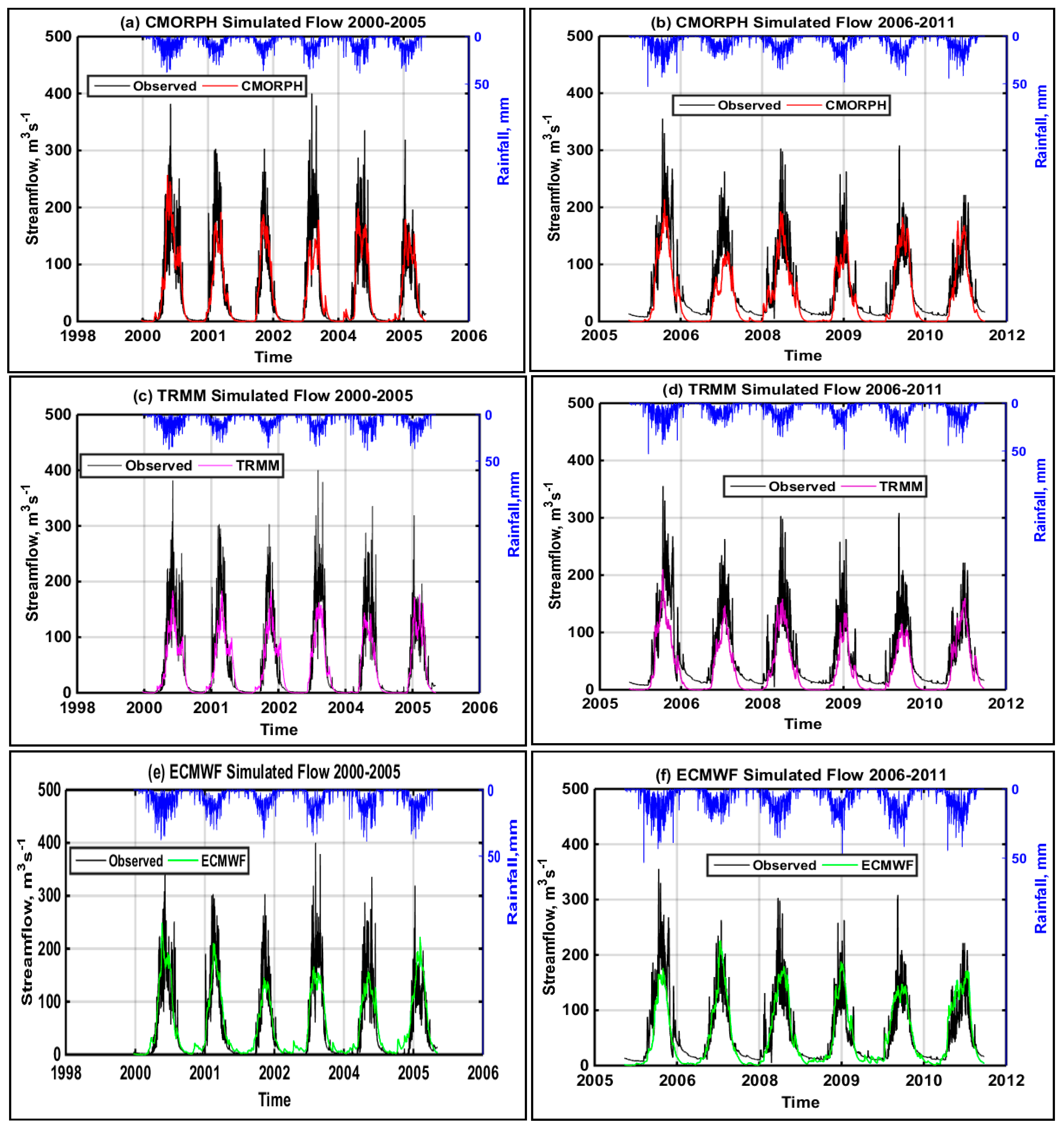
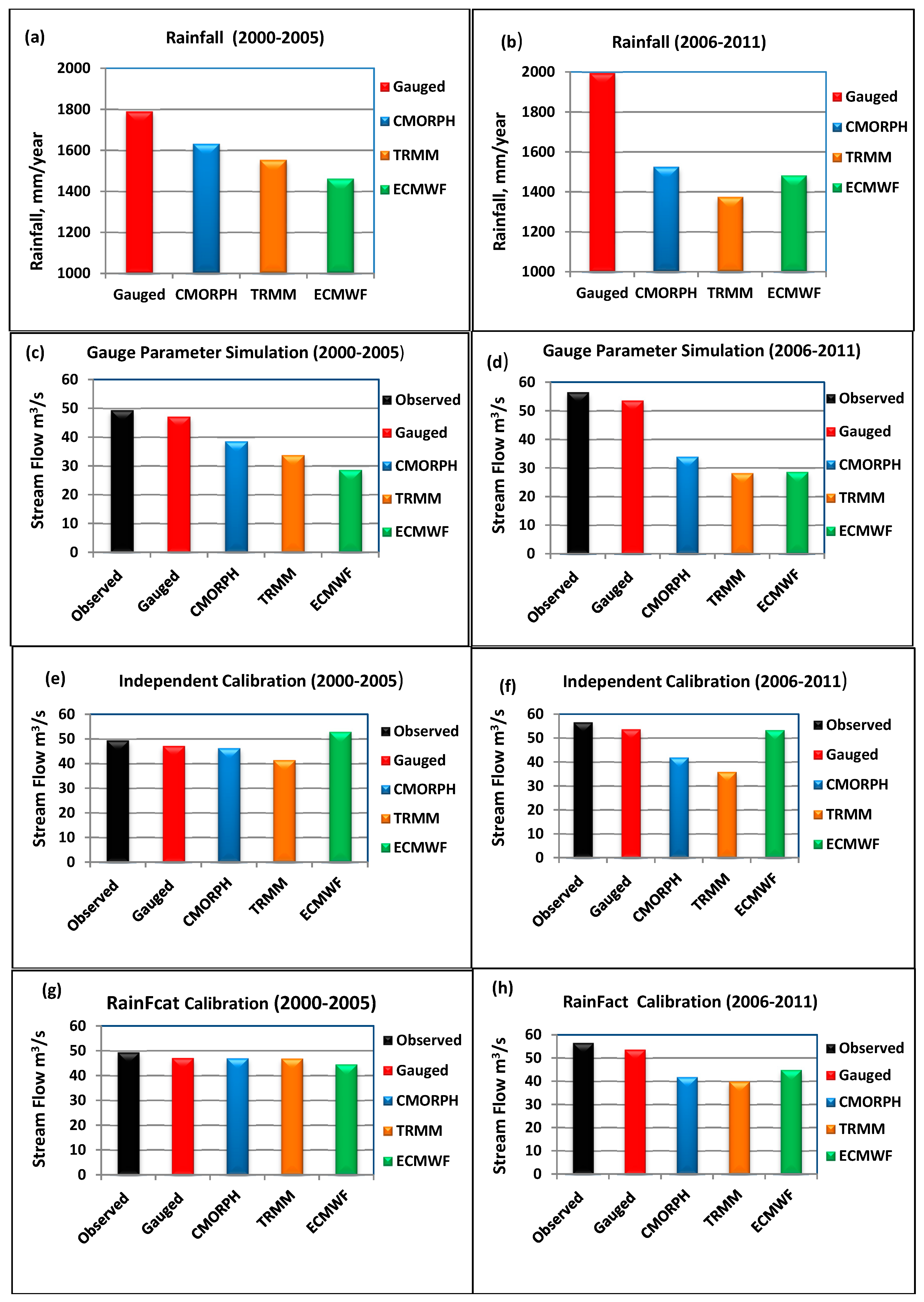
The performance of the model was accessed using gauge-based rainfall data to reproduce a hydrograph with NSCE of 0.82 for calibration and 0.67 for validation periods. The relative bias in both calibration and validation periods is within 5% of the observation for gauged rainfall (Table 2). The daily hydrograph of the three global precipitation products is well fitted for the independent calibration mode (Figure 2). Similarly, the results of the runoff hydrograph using the independent calibration mode shows a much better skill than previous work [4,5].This may be attributed to the distributed nature of the CREST model The CMORPH and ECMWF reproduced the runoff with NSCE of 0.78 and 0.75 for calibration and 0.71 and 0.72 for validation periods, respectively, under independent calibration mode. The performance of the TMPA 3B42v7 (TRMM) precipitation data is also encouraging with NSCE of 0.71 and 0.66 for the calibration and validation periods, respectively, under independent calibration (Table 2). All the global precipitation products underestimate the mean annual rainfall volume of the in-situ measured mean annual rainfall (Figure 3a,b). Generally, the mean annual runoff estimation decreases from CMORPH to TRMM for both calibration (2000–2005) and validation (2006–2011) periods shown in (Figure 3e,f) for independent calibration. TRMM underestimates the volume of flow relative to the other products with maximum bias of 16.3% and 36.6% in calibration and validation periods, respectively, for independent calibration (Table 2).
For the simulation mode (using calibrated gauged rainfall parameters),the performance in capturing the mean annual runoff is also encouraging for TRMM and CMORP Has shown in Figure 3c,d. The statistical performance (Table 2) shows CMORH and TRMM perform relatively well with respective NSCE values of the calibration period 0.72 and 0.65, as well as 0.6 and 0.5 for the validation period for the simulation mode. The performance of the reanalysis ECMWF satellite product for the simulation mode shows a relatively lower NSCE value of 0.57 for calibration and 0.49 for validation.
The performance of all precipitation products for the independent calibration mode indicates the global precipitation products capture the seasonal patterns of the runoff hydrograph (Figure 2). Further work is required to improve the annual volume of the precipitation products, especially the reanalysis product (ECMWF) as shown in Figure 3a,b. As a way of improving the performance in a simulation mode, we fine-tuned the rainfall factor (RainFact), which is one of the parameters in the CREST model and has a major role in multiplying the precipitation products in the field ranges from 0.6 to 2 to decrease the bias in the precipitation input for each precipitation product, and the results were improved significantly (Figure 3g,h). Figure 3 shows that the inherent bias in the mean annual volume of the simulated flow of each precipitation product emanates from the underestimation of the in-situ gauge-observed rainfall of the global precipitation products. The validation period shows consistently lower performance than the calibration period for all precipitation products. The low performance of the validation period may be related to the change of the location of the stream flow gauging station [5]. The station moved hundreds of meters downstream of the original site towards the end of 2005 due to road construction.
Evaluation of the flow quantiles using Quantile-Quantile (Q-Q) plots is shown in Figure 4. The Quantile-Quantile (Q-Q) plot is a graphical technique to determine if two data sets come from populations with a common distribution. A 45-degree reference line is also plotted. If the two sets come from a population with the same distribution, the points should fall approximately along this reference line. The greater the departure from this reference line, the greater the evidence for the conclusion that the two data sets have come from populations with different distributions or with the same distribution but biased or shifted with respect to the mean. The QQ-plot of the quantiles from the simulation mode (Figure 4b) shows all the precipitation products have high departure from the reference line except the in-situ rain gauge-simulated quantiles. The simulated flows of the global precipitation datasets consistently underestimate the quantiles in simulation modes (Figure 4b). In QQ-plots (Figure 4a,c), the flow quantiles plots cluster very well around the reference line. Particularly, the RainFact mode plot captures the higher quantile values and is better than other independent calibration and simulation modes. Overall, the result reveals that tuning the parameter ‘RainFact’, which is a rainfall multiplier, has shown to perform better than independent calibration (of all parameters) in QQ-plot evaluation to capture the peak flows for all the precipitation products (Figure 4c).

4. Conclusions

The aim of this study was to assess the performance of various satellite and reanalysis precipitation datasets for water resource applications in the Upper Blue Nile basin, Ethiopia, applying different calibration and simulation conditions (modes). The Coupled Routing and Excess Storage (CREST V.2.1) fully distributed hydrological model was setup for different simulation modes for Gilgel Abbay watershed (Area = 1656 km2) in the upper Blue Nile Basin.
  • Examination of the parameters of the model indicates Saturated Hydraulic Conductivity (Ksat), Mean Water holding capacity (WM) and the overland runoff velocity coefficient (coeM) showed wide range parameter values for the different precipitation products of independent calibration. These three parameters are less sensitive relative to the other parameters. It is also noted that other model parameters are sensitive and remain nearly the same for the tested precipitation products. The most sensitive parameter is RainFact.
  • The in-situ gauge observed rainfall data reproduce the runoff very well (NSCE = 0.82) as compared to the observed daily discharge at the outlet of the watershed at Gilgel Abbay catchment, indicating the CREST model has the ability to capture the hydrological processes and to evaluate the global precipitation products.
  • In terms of comparing the performance of the satellite and reanalysis precipitation products, all products under independent and RainFact calibration mode reproduce daily streamflow better than the simulation mode with NSCE performance above 70% in calibration and 60% in validation periods.
  • In simulation mode, though the NSCE performance is reasonable (CMORPH and TRMM), the runoff volume and extreme flow ranges are underestimated as indicated by the bias and QQ-plots. The ECMWF reanalysis product underestimates the runoff results more than other tested precipitation products. However, the ECMWF reanalysis product has shown significant improvement in independent calibration and RainFact calibration modes to capture the reference line on the simulated high flows. Generally, the RainFact calibration mode enhances the simulated flows in capturing high flows of the observed streamflow in the QQ-plot.
  • The validation period shows consistently poorer performance than the calibration period for all precipitation products due to the movement of the stream flow gauging station, i.e., hundreds of meters downstream of the original site towards the end of 2005 due to road construction. Therefore, we can conclude that satellite and reanalysis precipitation products can be used for water resource planning and management under independent calibration mode. Further analysis is underway to understand the response characteristics of the precipitation products at a larger scale of Blue Nile basin.

Acknowledgments

This work was supported by the EU-funded Earth2Observe (ENVE.2013.6.3-3) project. The authors would like to thank the editor and anonymous reviewers for their constructive comments and suggestions, which have substantially improved the quality of this manuscript. This study was coordinated by Addis Ababa University, School of Civil and Environmental Engineering

Author Contributions

Haileyesus Belay Lakew set and run the model in different modes and wrote the paper; Semu Ayalew Moges and Dereje Hailu Asfaw supervised the paper work.

Conflicts of Interest

The authors declare no conflict of interest.

References

  1. African Climate Policy Centre (ACPC). Climate Change and Water in Africa: Analysis of Knowledge Gaps and Needs; African Climate Policy Centre: Addis Ababa, Ethiopia, 2011. [Google Scholar]
  2. Dinku, T.; Ceccato, P.; Grover-Kopec, E.; Lemma, M.; Connor, S.J.; Ropelewski, C.F. Validation of satellite rainfall products over East Africa’s complex topography. Int. J. Remote Sens. 2007, 28, 1503–1526. [Google Scholar] [CrossRef]
  3. Hirpa, F.A.; Gebremichael, M.; Hopson, T. Evaluation of high-resolution satellite precipitation products over very complex terrain in Ethiopia. J. Appl. Meteorol. Climatol. 2010, 49, 1044–1051. [Google Scholar] [CrossRef]
  4. Bitew, M.; Gebremichael, M. Evaluation of high-resolution satellite rainfall products through streamflow simulation in a hydrological modeling of a small mountainous watershed in Ethiopia. J. Hydrometeorol. 2011, 13, 338–350. [Google Scholar] [CrossRef]
  5. Habib, E.; Haile, A.T.; Sazib, N.; Zhang, Y.; Rientjes, T. Effect of bias correction of satellite-rainfall estimates on runoff simulations at the source of the Upper Blue Nile. Remote Sens. 2014, 6, 6688–6708. [Google Scholar] [CrossRef]
  6. Joyce, R.J.; Janowiak, J.E.; Arkin, P.A.; Xie, P. CMORPH: A method that produces global precipitation estimates from passive microwave and infrared data at high spatial and temporal resolution. J. Hydrometeorol. 2004, 5, 487–503. [Google Scholar] [CrossRef]
  7. Huffman, G.J.; Bolvin, D.T.; Nelkin, E.J.; Wolff, D.B.; Adler, R.F.; Gu, G.; Hong, Y.; Bowman, K.P.; Stocker, E.F. The TRMM multisatellite precipitation analysis (TMPA): Quasi-global multilayer, combined-sensor, precipitation estimates atfine scale. J. Hydrometeorol. 2007, 8, 38–55. [Google Scholar] [CrossRef]
  8. Andersson, E. User Guide to ECMWF Forecast Products; ECMWF: Reading, UK, 2015; Volume 1.2. [Google Scholar]
  9. Shen, X.; Hong, Y.; Zhang, K.; Hao, Z. Refine a distributed linear reservoir routing method to improve performance of the CREST model. Hydrol. Sci. J. 2014. [Google Scholar] [CrossRef]
  10. Wang, J.; Hong, Y.; Li, L.; Gourley, J.J.; Khan, S.I.; Yilmazd, K.K.; Robert, F.; Adlerd, R.F.; Policelli, F.S.; Habib, S.; et al. The coupled routing and excess storage (CREST) distributed hydrological model. Hydrol. Sci. J. 2011, 56. [Google Scholar] [CrossRef]
  11. Duan, Q.; Sorooshian, S.; Gupta, V. Effective and efficient global optimization for conceptual rainfall-runoff models. Water Resour. Res. 1992, 28, 1015–1031. [Google Scholar] [CrossRef]
  12. Chu, W.; Gao, X.; Sorooshian, S. Improving the shuffled complex evolution scheme for optimization of complex nonlinear hydrological systems: Application to the calibration of the Sacramento soil-moisture accounting model. Water Resour. Res. 2010. [Google Scholar] [CrossRef]
  13. Nash, J.; Sutcliffe, J. River flow forecasting through conceptual models. Part I: A discussion of principles. J. Hydrol. 1970, 10, 282–290. [Google Scholar] [CrossRef]
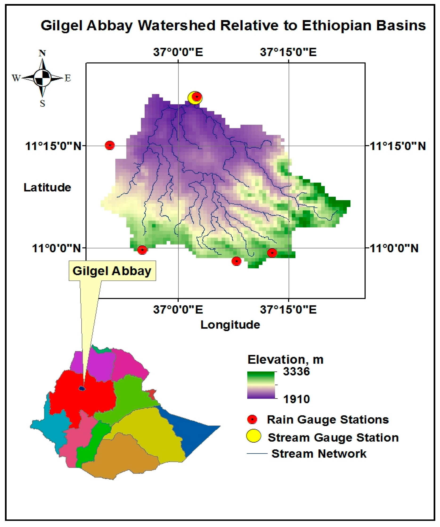
Figure 1. The study region in Ethiopia, Upper Blue Nile: Gilgel Abbay watershed (1656 km2) with locations of five nearby rain gauge stations of the study region, and one stream gauge station at the outlet of the watershed with 0.25° grid resolution.
Hydrology 04 00039 g001
Figure 2. Hydrograph of simulated flow of global precipitation products with observed flow of Gilgel Abbay watershed for the independent calibration mode (a,b) CMORPH, (c,d) TRMM,(e,f) ECMWF.
Hydrology 04 00039 g002
Figure 3. Different precipitation products comparison of (a,b) Average annual rainfall, (c,d) Average annual flow for simulation mode, (e,f) Average annual flow for Independent calibration mode, (g,h) Average annual flow for RainFact calibration mode.
Hydrology 04 00039 g003
Figure 4. Quantile-Quantile plot of Gilgel Abbay watershed for (a) Independent calibration, (b) In-situ Gauge parameter simulation, (c) RainFact Calibration
Hydrology 04 00039 g004
Table 1. Estimated parameter values of independent calibrations for different precipitation products.
ParameterDescriptionUnitRain GaugeCMORPHTRMM (3B42v7)ECMWF
RainFactThe multiplier in the precipitation field----1.3991.38971.39941.8867
KsatThe Soil saturated hydraulic conductivitymm/day143.3117.87116.6335.212
MWThe Mean Water Capacitymm260.954.38887.69360.21
BThe exponent of the variable infiltration Curve----0.7500.7810.755250.15715
IMThe impervious area ratio----0.0160.089060.0161350.0555
KEThe factor to convert the PET to local actual values----1.1930.829520.815810.8506
coeMThe overland runoff velocity coefficient----25.3664.296111.0366.624
expMThe overland flow speed exponent----0.2700.171030.2976350.3109
coeRThe multiplier used to convert overland flow
The speed to channel flow speed
----1.9482.5522.37681.5467
coeSThe multiplier used to convert overland flow
The speed to interflow flow speed
----0.5470.357330.81690.5881
KSThe overland reservoir Discharge Parameter----0.1070.081520.06930.0307
KIThe interflow Reservoir Discharge Parameter----0.0810.065680.067820.0669
Table 2. Different calibration and simulation modes results of global precipitation products and gauged rainfall.
Precipitation DataIndependent Calibration Mode (Model Calibrated to Each Precipitation Input)Simulation Mode (Using Calibrated Gauged Rainfall Parameters)RainFact Calibration Mode (Using Calibrated Gauged Rainfall Parameters and Only RainFact Parameter Is Calibrated)
Gauged RainfallCalibration 2000–2005
NSCE = 0.82NSCE = 0.82NSCE = 0.82
Bias(%) = −4.6Bias(%) = −4.6Bias(%) = −4.6
CC = 0.91CC = 0.91CC = 0.91
Validation 2006–2011
NSCE = 0.67NSCE = 0.67NSCE = 0.67
Bias(%) = −5Bias(%) = −5Bias(%) = −5
CC = 0.89CC = 0.89CC = 0.89
CMORPHCalibration 2000–2005
NSCE = 0.78NSCE = 0.72NSCE = 0.75
Bias(%) = −6.5Bias(%) = −21.9Bias(%) = −4.8
CC = 0.88541CC = 0.86497CC = 0.87
Validation 2006–2011
NSCE = 0.71NSCE = 0.60NSCE = 0.68
Bias(%) = −25.9Bias(%) = −39.9Bias(%) = −26.0
CC = 0.88CC = 0.87CC = 0.87
TRMMCalibration 2000–2005
NSCE = 0.71NSCE = 0.65NSCE = 0.70
Bias(%) = −16.3Bias(%) = −31.5Bias(%) = −19.2
CC = 0.87CC = 0.86CC = 0.86
Validation 2006–2011
NSCE = 0.66NSCE = 0.50NSCE = 0.64
Bias(%) = −36.6Bias(%) = −50.0Bias(%) = −38.0
CC = 0.89CC = 0.87CC = 0.88
ECMWFCalibration 2000–2005
NSCE = 0.75NSCE = 0.57NSCE = 0.73
Bias(%) = −1.6Bias(%) = −42.0Bias(%) = −6.5
CC = 0.87CC = 0.85CC = 0.86
Validation 2006–2011
NSCE = 0.72NSCE = 0.49NSCE = 0.68
Bias(%) = −12.9Bias(%) = −49.3Bias(%) = −17.6
CC = 0.87CC = 0.86CC = 0.86