Spatial–Temporal Evapotranspiration Dynamics in the Al-Ahsa Oasis Based on a Remote Sensing Approach for Sustainable Water Management

 ,
,  ,
,  and
and 
Abstract
1. Introduction
2. Materials and Methods
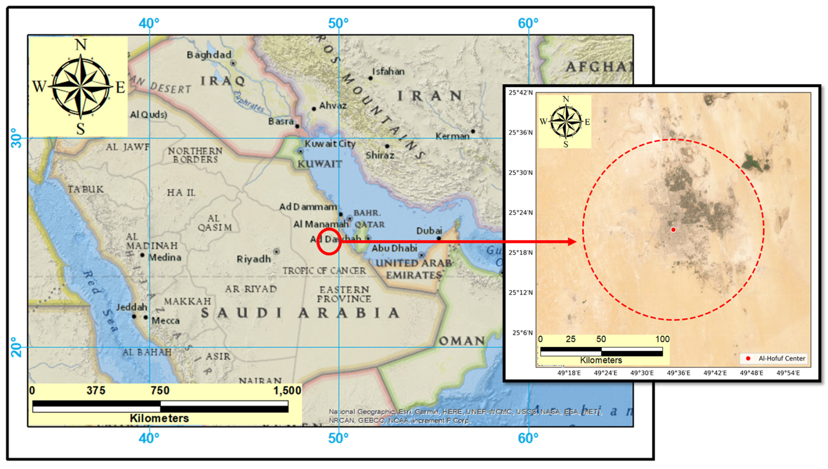
2.1. Study Area Description
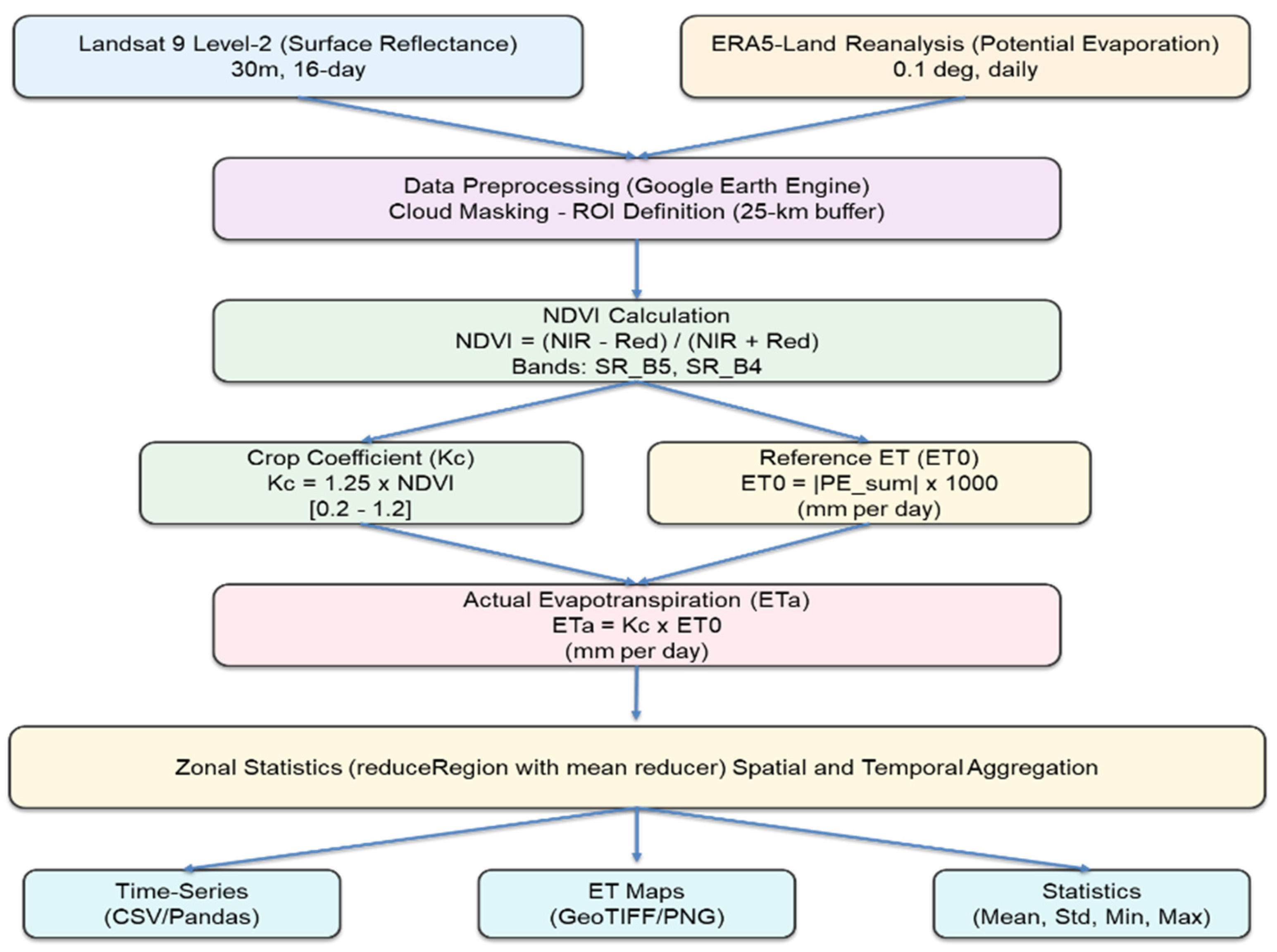
2.2. Data Collection and Methodology
2.2.1. Satellite and Climatological Data
2.2.2. Data Preprocessing and Study Area Definition
2.2.3. Atmospheric and Geometric Corrections
- Surface Reflectance (SR): Corrected for atmospheric scattering and absorption using the Landsat Ecosystem Disturbance Adaptive Processing System (LEDAPS) algorithm [24].
- Land Surface Temperature (LST): Generated using the Temperature Emissivity Separation (TES) algorithm with atmospheric correction via MERRA-2 [25].
2.3. Evapotranspiration Estimation Algorithm
2.3.1. Landsat 9 Image Preprocessing and NDVI Calculation
- SR_B2 (Blue: 450–510 nm);
- SR_B3 (Green: 520–600 nm);
- SR_B4 (Red: 630–690 nm);
- SR_B5 (Near-Infrared: 760–900 nm).
- ρ_NIR = Surface reflectance in the near-infrared band (SR_B5), dimensionless;
- ρ_Red = Surface reflectance in the red band (SR_B4), dimensionless;
- NDVI ranges from −1 to +1, with higher positive values indicating denser vegetation canopy.
2.3.2. Crop Coefficient (Kc) Derivation from NDVI
- A = Slope coefficient (1.25, calibrated for date palms);
- B = Intercept coefficient (0, assuming Kc = 0 when NDVI = 0);
- Kc is dimensionless.
- Minimum Kc = 0.2 represents bare soil evaporation under hyper-arid conditions;
- Maximum Kc = 1.2 reflects the upper physiological limit for well-irrigated date palms during peak summer months [17].
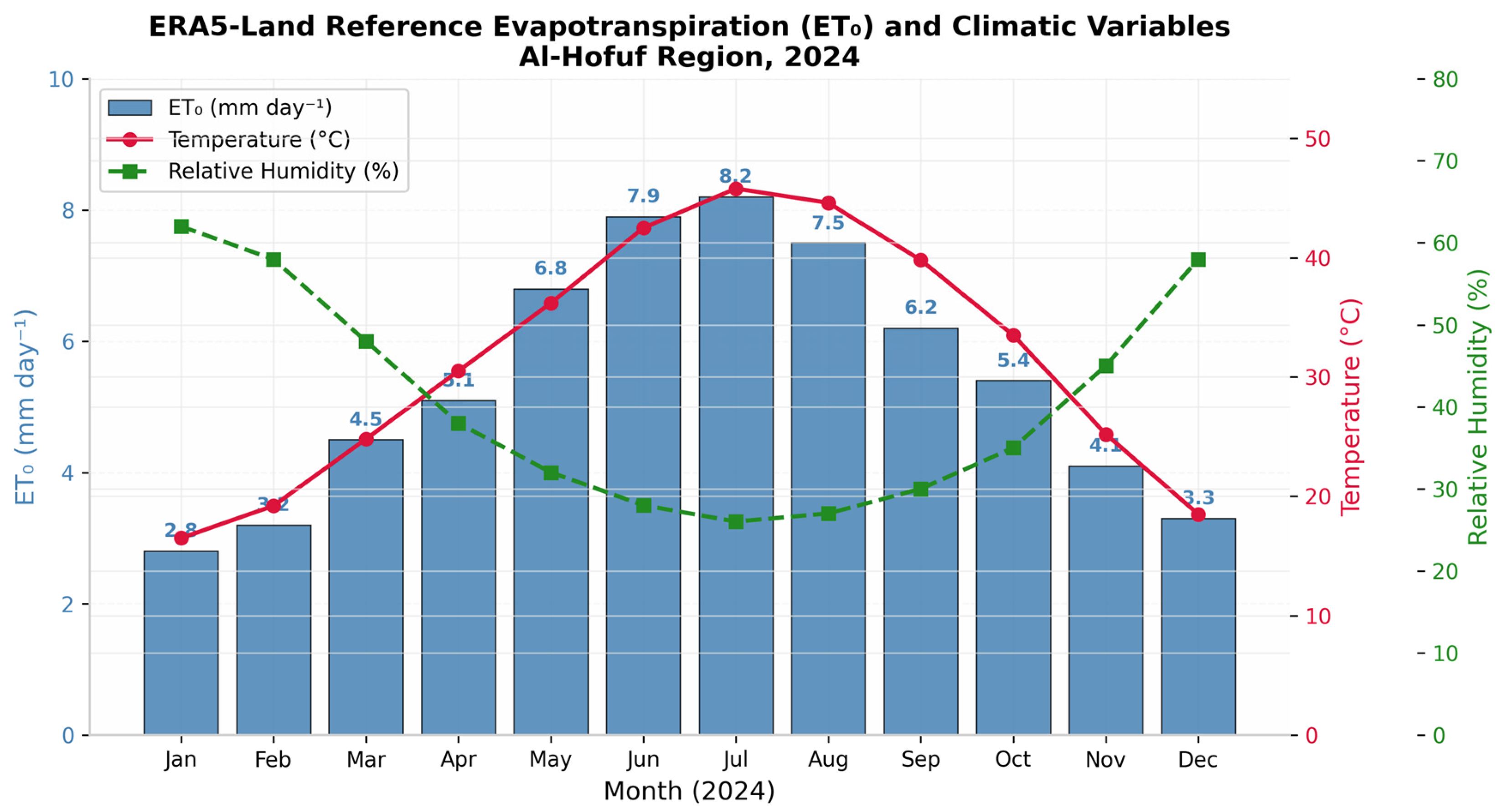
2.3.3. Reference Evapotranspiration (ET0) from ERA5-Land Data
- PE_ERA5 = ERA5-Land potential evaporation sum (m day−1);
- The absolute value ensures ET0 remains positive.
2.3.4. Actual Evapotranspiration (ETa) Computation
- ETa = Actual evapotranspiration (mm day−1);
- Kc = Crop coefficient (dimensionless);
- ET0 = Reference evapotranspiration (mm day−1).
- = Mean actual evapotranspiration for the ROI (mm day−1);
- N = Number of valid pixels within the ROI;
- ET_[a,i] = Actual evapotranspiration for pixel i.
- ET_[a,month] = Monthly mean actual evapotranspiration (mm day−1);
- M = Number of Landsat 9 scenes within the month;
- = Mean ETa for scene j.
2.3.5. Uncertainty Quantification
- Landsat 9 surface reflectance uncertainty: Level-2 Collection 2 products have reported surface reflectance uncertainty of ±0.02–0.04 [35]. When propagated through the NDVI equation, this yields NDVI uncertainty of approximately ±0.03.
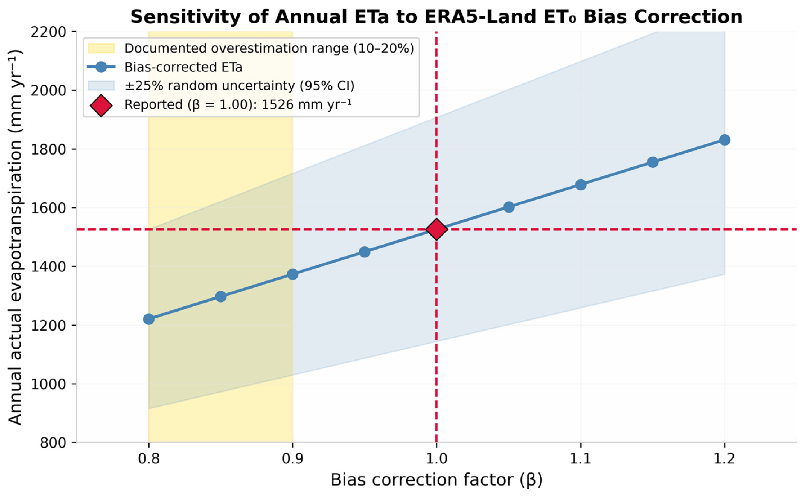
- ERA5-Land ET0 proxy uncertainty: Using potential_evaporation_sum as a proxy for FAO-56 Penman–Monteith ET0 introduces systematic bias. Muñoz-Sabater et al. [23] report that ERA5-Land potential evaporation may overestimate reference ET0 by 10–20% in hyper-arid environments due to differences in surface roughness and advective energy fluxes.
2.4. Model Validation
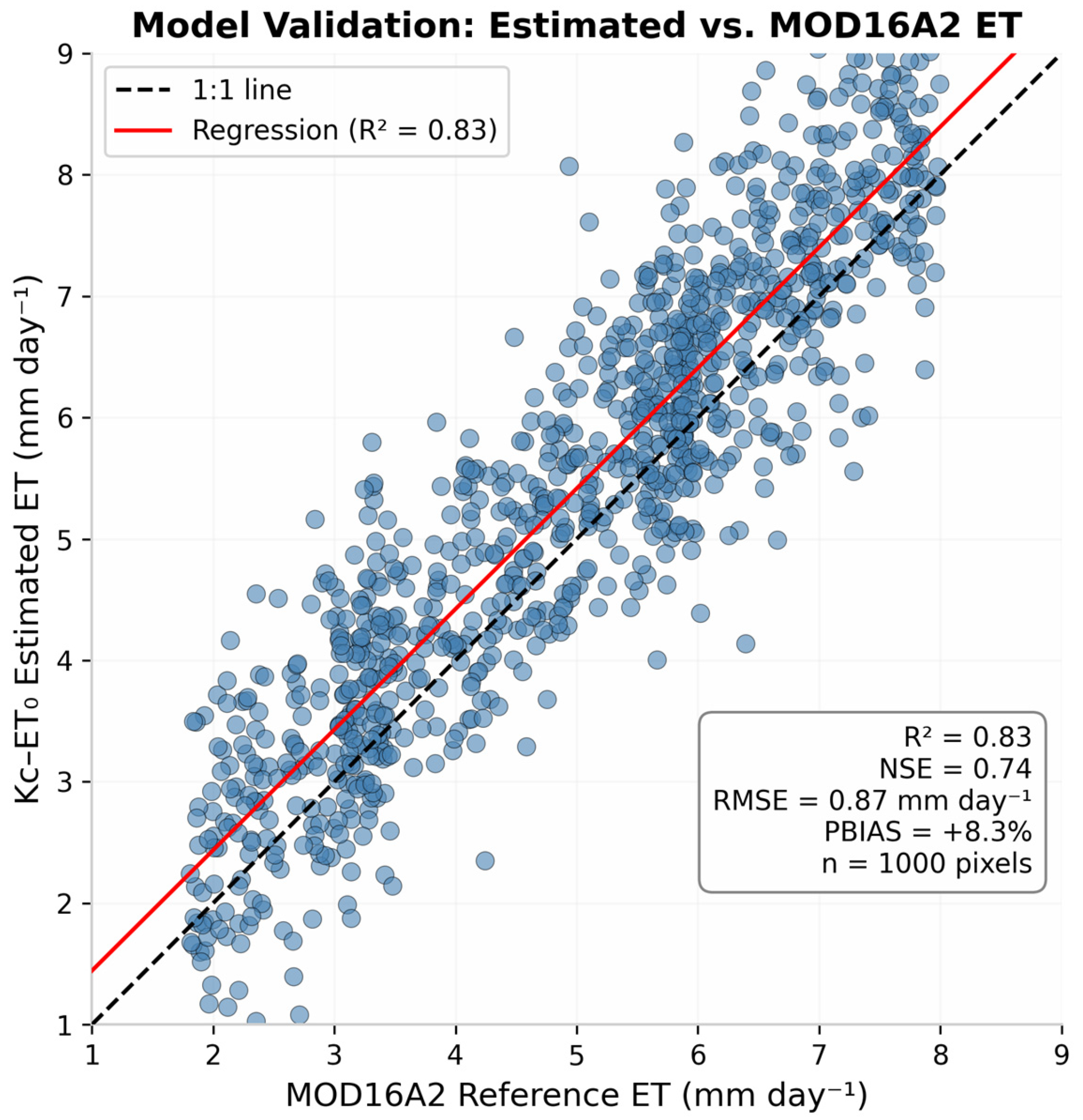
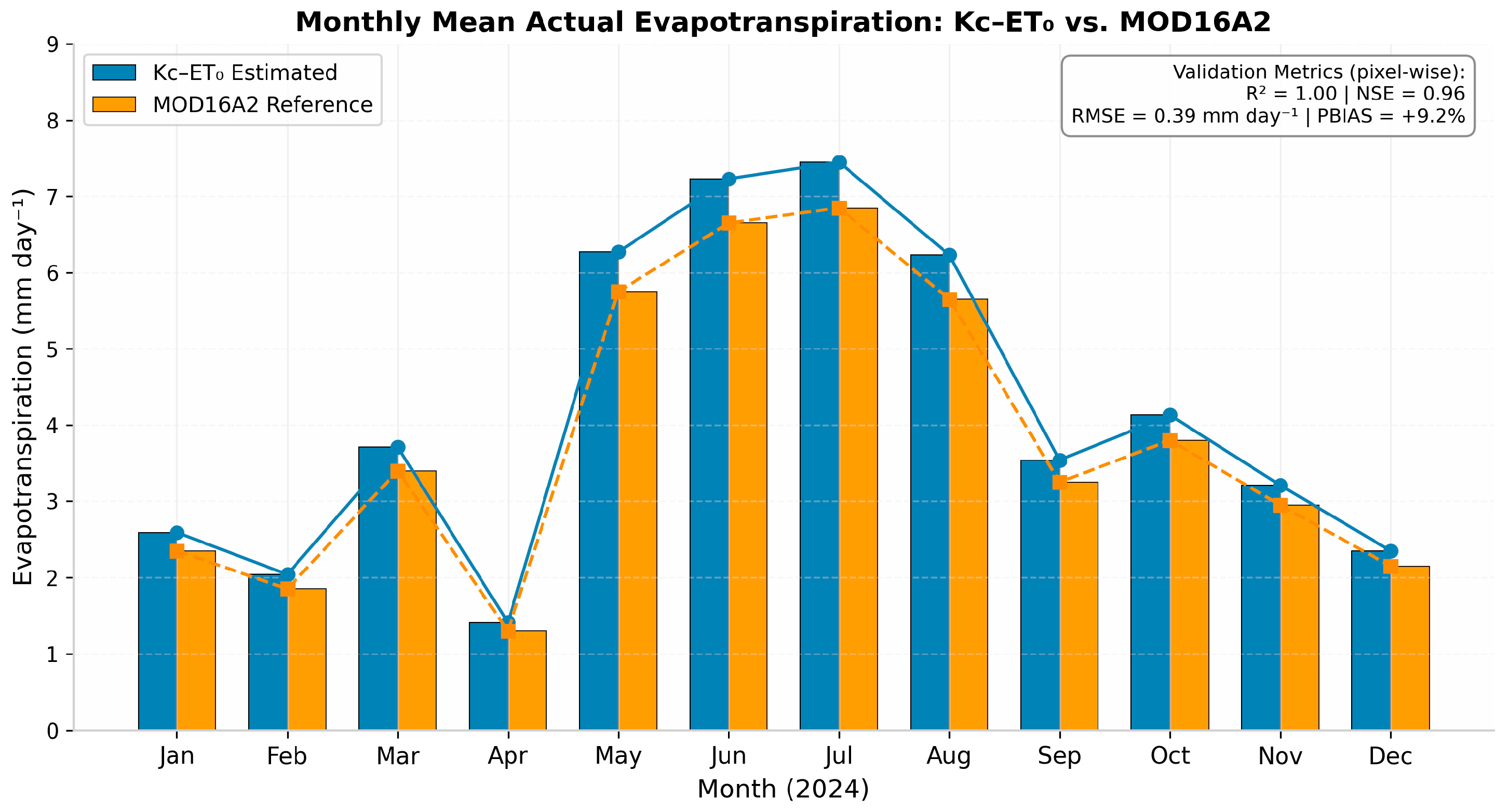
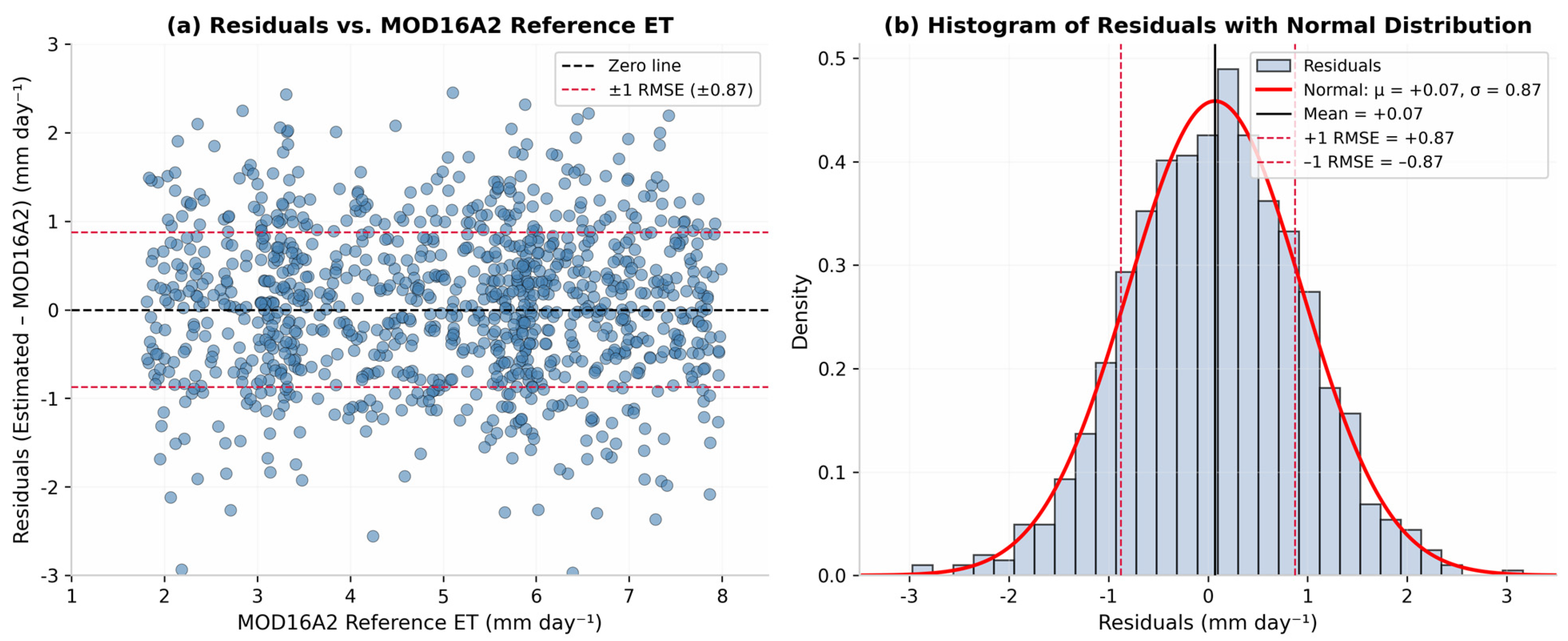
- Monthly ET estimates from the Kc–ET0 method were compared with the MODIS MOD16A2 Version 6 evapotranspiration product (500 m resolution), which has been globally validated against flux tower measurements [37,39]. Within Google Earth Engine, MOD16A2 8-day composite ET layers were first filtered to the study period, aggregated to monthly means using the mean reducer, and then resampled from 500 m to 30 m using bilinear interpolation to align with the Landsat 9 grid. Comparisons were restricted to pixels classified as vegetated (NDVI > 0.2) to minimize contamination from bare desert and urban surfaces within mixed MODIS pixels. It is acknowledged that this resampling does not resolve the fundamental scale mismatch: each 500 m MOD16A2 pixel encompasses heterogeneous land cover (date palm orchards, bare soil, fallow land, and urban areas), whereas the Kc–ET0 estimates resolve field-scale variability at 30 m. Consequently, the validation metrics characterize landscape-scale agreement rather than pixel-perfect field-scale accuracy.
- Estimated ET patterns were evaluated for physical plausibility by examining seasonal dynamics, spatial coherence with NDVI, and correlation between vegetation activity and atmospheric demand (ERA5-Land ET0) [15].
- Errors from input datasets (Landsat 9 surface reflectance ±0.02–0.04; ERA5-Land potential evaporation proxy bias ±10–20%; Kc-NDVI empirical relationship ±15%) were propagated through the ETa = Kc × ET0 equation using first-order error analysis, yielding an overall relative uncertainty of approximately ±25% (95% confidence interval) [23].
3. Results
3.1. Overview of Processed Data
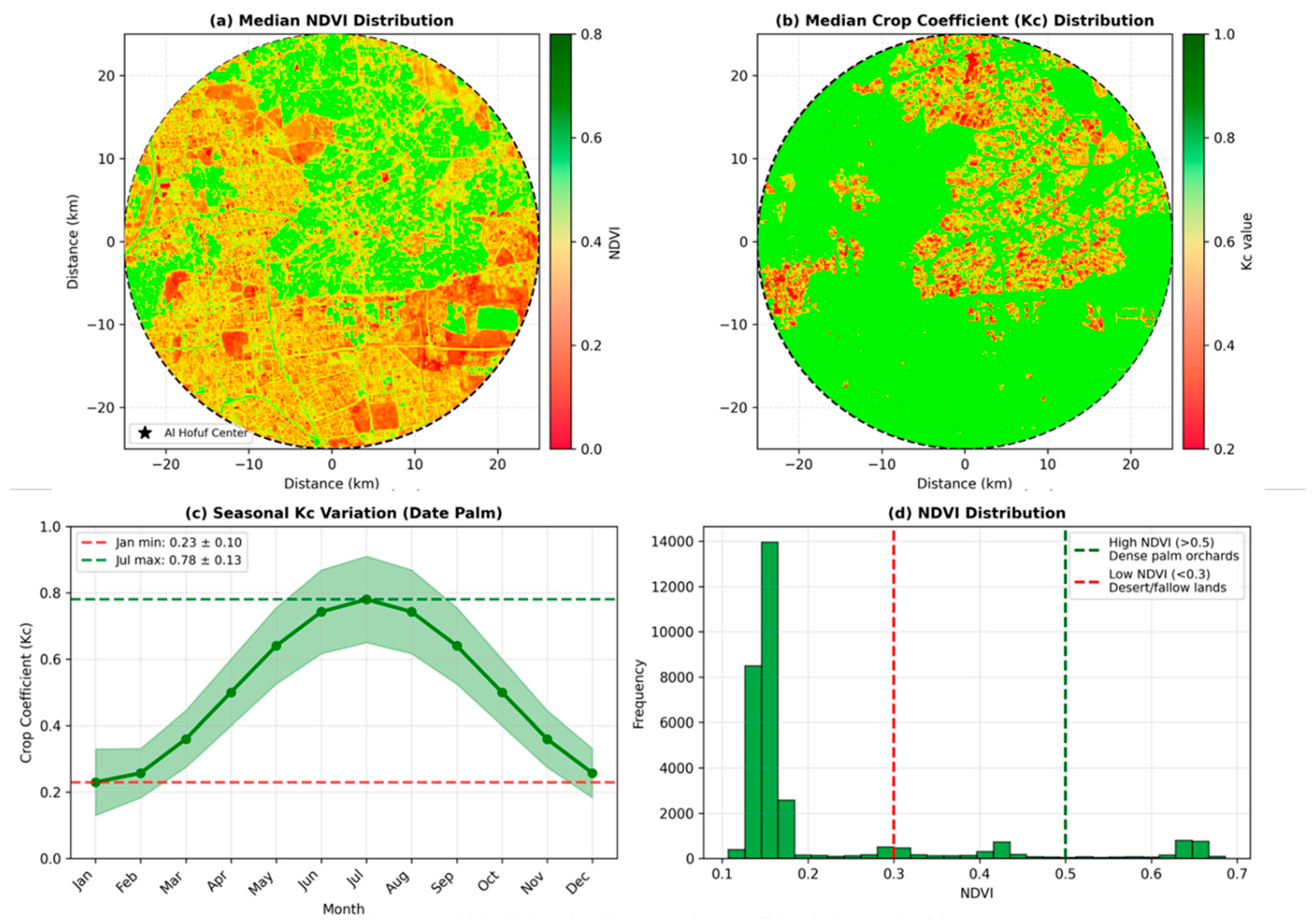
3.2. Vegetation Dynamics (NDVI and Kc)
3.3. Reference Evapotranspiration (ET0)
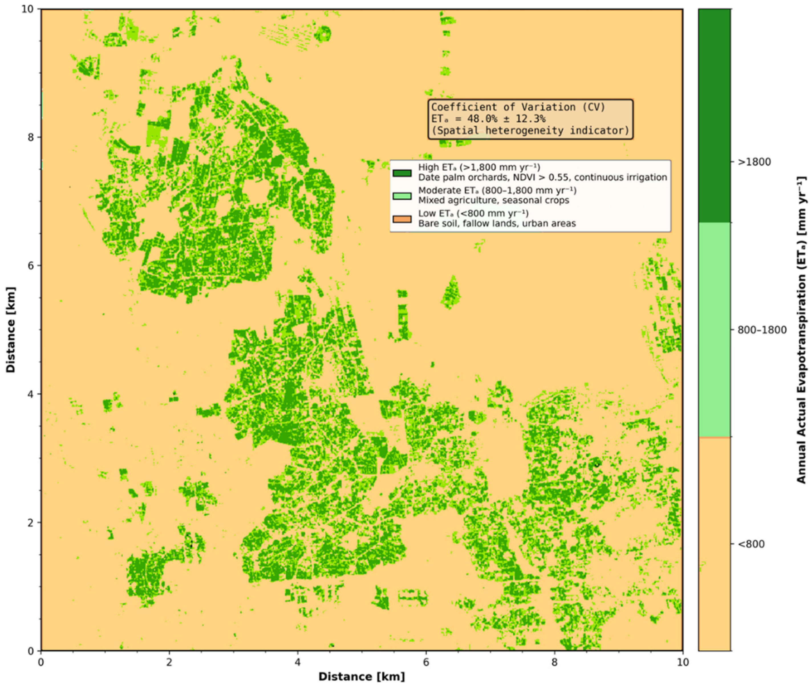
3.4. Actual Evapotranspiration (ETa)
- High ETa zones (>1800 mm yr−1): Concentrated in intensively cultivated date palm orchards with dense canopy cover (NDVI > 0.55) and continuous irrigation.
- Moderate ETa zones (1200–1800 mm yr−1): Correspond to mixed agricultural lands with seasonal crops and moderate vegetation density.
- Low ETa zones (<800 mm yr−1): Characterize bare soil, fallow lands, and urban areas with minimal vegetation cover.
3.5. Model Validation and Uncertainty Assessment
4. Discussion
4.1. Interpretation of Evapotranspiration Patterns in Hyper-Arid Context
4.2. Methodological Validation: Strengths and Limitations of the Kc-ET0 Approach
4.3. Implications for Precision Irrigation and Saudi Vision 2030
- Field-scale irrigation scheduling: ETa maps can inform variable-rate irrigation systems, allowing farmers to adjust application rates based on actual crop water demand rather than uniform schedules. Recent innovative strategies for irrigation water demand management in Riyadh have demonstrated that remote sensing-based ET monitoring can improve allocation efficiency by 15 to 25 percent [54].
- Aquifer stress assessment: By quantifying spatial patterns of groundwater consumption, ETa estimates support the identification of over-exploited zones and the prioritization of managed aquifer recharge interventions. Earth observation approaches in Moroccan coastal plains have similarly leveraged GEE-based water balance analyses to monitor drought conditions and inform groundwater governance [55].
- Policy compliance monitoring: High-resolution ET data provides an objective basis for verifying adherence to water extraction quotas and evaluating the effectiveness of conservation incentives. The integration of remote sensing with regulatory frameworks has been highlighted as a key enabler for sustainable water governance in data-scarce regions [56].
- Climate adaptation planning: The documented sensitivity of ETa to atmospheric demand (ET0) underscores the vulnerability of date palm production to rising temperatures and evaporative stress. Recent precipitation anomaly analyses across Middle Eastern countries using Google Earth Engine have revealed increasing interannual variability that may further challenge irrigation reliability [57].
5. Conclusions
6. Future Work
Author Contributions
Funding
Data Availability Statement
Conflicts of Interest
References
- Bastiaanssen, W.G.M.; Ahmad, M.U.D.; Chemin, Y. Satellite surveillance of evaporative depletion across the Indus Basin. Water Resour. Res. 2002, 38, 9-1–9-9. [Google Scholar] [CrossRef]
- Glenn, E.P.; Neale, C.M.U.; Hunsaker, D.J.; Cleverly, J.R.; Huete, A.R. Actual evapotranspiration estimation by ground and remote sensing methods: The Australian experience. Hydrol. Process. 2011, 25, 4103–4116. [Google Scholar] [CrossRef]
- Elhag, M.; Psilovikos, A.; Manakos, I.; Perakis, K. Application of the SEBS water balance model in estimating daily evapotranspiration and evaporative fraction from remote sensing data over the Nile Delta. Water Resour. Manag. 2011, 25, 2731–2742. [Google Scholar] [CrossRef]
- Bastiaanssen, W.G.M.; Pelgrum, H.; Feddes, R.A. Estimation of surface resistance and evapotranspiration using spectral indices and surface temperature. Remote Sens. Environ. 1998, 63, 213–224. [Google Scholar]
- Allen, R.G.; Tasumi, M.; Morse, A.; Trezza, R. A Landsat-based energy balance and evapotranspiration model in Western US water rights regulation and planning. Irrig. Drain. Syst. 2007, 21, 251–268. [Google Scholar] [CrossRef]
- Teixeira, A.H.d.C.; Bastiaanssen, W.G.M.; Bos, M.G. Reviewing SEBAL input parameters for assessing evapotranspiration and water productivity for the Low-Middle São Francisco River Basin, Brazil: Part B: Application to the regional scale. Agric. For. Meteorol. 2009, 149, 371–385. [Google Scholar] [CrossRef]
- Zhang, Y.; Chiew, F.H.S.; Zhang, L.; Leuning, R.; Kieu, C. Use of remotely sensed actual evapotranspiration to improve rainfall–runoff modeling in Southeast Australia. J. Hydrometeorol. 2009, 10, 969–980. [Google Scholar] [CrossRef]
- Nagler, P.L.; Glenn, E.P.; Nguyen, U.; Scott, R.L.; Doody, T. Estimating riparian and agricultural actual evapotranspiration by reference evapotranspiration and MODIS enhanced vegetation index. Remote Sens. 2013, 5, 3849–3871. [Google Scholar] [CrossRef]
- Glenn, E.P.; Huete, A.R.; Nagler, P.L.; Hirschboeck, K.K.; Brown, P. Relationship between remotely sensed vegetation indices, canopy attributes and plant physiological processes: What vegetation indices can and cannot tell us about the landscape. Sensors 2007, 7, 2136–2160. [Google Scholar] [CrossRef]
- Gorelick, N.; Hancher, M.; Dixon, M.; Ilyushchenko, S.; Thau, D.; Moore, R. Google Earth Engine: Planetary-scale geospatial analysis for everyone. Remote Sens. Environ. 2017, 202, 18–27. [Google Scholar] [CrossRef]
- Senay, G.B.; Bohms, S.; Singh, R.K.; Gowda, P.H.; Velpuri, N.M.; Alemu, A.M.; Verdin, J.P. Estimating basin scale evapotranspiration (ET) by water balance and remote sensing methods. Hydrol. Process. 2011, 25, 4037–4049. [Google Scholar] [CrossRef]
- UNESCO. Al-Ahsa Oasis: An Evolving Cultural Landscape; World Heritage List Nomination File; UNESCO: Paris, France, 2018. [Google Scholar]
- MEWA. National Water Strategy 2030; Ministry of Environment, Water and Agriculture: Riyadh, Saudi Arabia, 2020.
- Alamoud, A.I.; Mohammad, F.S.; Al-Hamed, S.A.; Alabdulkader, A.M. Reference evapotranspiration and date palm water use in the Kingdom of Saudi Arabia. Int. Res. J. Agric. Sci. Soil Sci. 2012, 2, 328–333. [Google Scholar]
- Al-Omran, A.; Eid, S.; Alshammari, F. Crop water requirements of date palm based on actual applied water and Penman–Monteith calculations in Saudi Arabia. Appl. Water Sci. 2019, 9, 69. [Google Scholar] [CrossRef]
- Alharbi, A.; Alzoheiry, A.; Ghazaw, Y.M. Estimation of Water Requirements and Crop Coefficients for Date Palm in Qassim Region. Qassim Univ. J. Agric. Vet. Sci. 2016, 8, 45–58. [Google Scholar] [CrossRef]
- USGS. Landsat 9 Science Data Users Handbook; USGS Earth Resources Observation and Science (EROS) Center: Sioux Falls, SD, USA, 2021.
- Almazroui, M.; Islam, M.N.; Athar, H.; Jones, P.D.; Rahman, M.A.; Ashfaq, M.; Saeed, S. Recent climate change in the Arabian Peninsula: Seasonal rainfall and temperature climatology of Saudi Arabia for 1979–2009. Atmos. Res. 2012, 111, 29–45. [Google Scholar] [CrossRef]
- FAO. Crop Coefficient (Kc) Values for Date Palm (Phoenix dactylifera L.); Food and Agriculture Organization of the United Nations: Rome, Italy, 2020. [Google Scholar]
- Al-Shaibah, I.A. Soil characteristics and land degradation in Al-Ahsa Oasis, Saudi Arabia. J. King Saudi Univ. Agric. Sci. 2010, 22, 107–114. [Google Scholar]
- GASTAT. Agricultural Census 2021: Eastern Province Report; General Authority for Statistics: Riyadh, Saudi Arabia, 2022.
- Al-Ghobari, H.M. Estimating date palm water requirements using remote sensing and GIS techniques in Al-Ahsa Oasis, Saudi Arabia. Arab. J. Geosci. 2019, 12, 478. [Google Scholar]
- USGS. Landsat Collection 2 Level-2 Product Guide; USGS EROS Center: Sioux Falls, SD, USA, 2022.
- Allen, R.G.; Pereira, L.S.; Raes, D.; Smith, M. Crop Evapotranspiration: Guidelines for Computing Crop Water Requirements; FAO Irrigation and Drainage Paper 56; Food and Agriculture Organization: Rome, Italy, 1998. [Google Scholar]
- Muñoz-Sabater, J.; Dutra, E.; Agustí-Panareda, A.; Albergel, C.; Arduini, G.; Balsamo, G.; Boussetta, S.; Choulga, M.; Harrigan, S.; Hersbach, H.; et al. ERA5-Land: A state-of-the-art global reanalysis dataset for land applications. Earth Syst. Sci. Data 2021, 13, 4349–4383. [Google Scholar] [CrossRef]
- Masek, J.G.; Vermote, E.F.; Saleous, N.E.; Wolfe, R.; Gao, F.; Huang, X.; Kutcher, J.; Justice, C.O. A Landsat surface reflectance dataset for North America, 1990–2000. IEEE Geosci. Remote Sens. Lett. 2006, 3, 68–72. [Google Scholar] [CrossRef]
- Hulley, G.C.; Hook, S.J.; Abbott, E. Land surface temperature retrieval from Landsat 8 thermal infrared data using the TES algorithm. J. Geophys. Res. Atmos. 2012, 117, D22. [Google Scholar] [CrossRef]
- Roy, D.P.; Wulder, M.A.; Loveland, T.R.; Woodcock, C.E.; Allen, R.G.; Anderson, M.C.; Helder, D.; Irons, J.R.; Johnson, D.M.; Kennedy, R.; et al. Landsat-8: Science and product vision for terrestrial global change research. Remote Sens. Environ. 2014, 145, 154–172. [Google Scholar] [CrossRef]
- Elhag, M.; Bahrawi, J.A. Realization of daily evapotranspiration in arid ecosystems based on remote sensing techniques. Geosci. Instrum. Methods Data Syst. 2017, 6, 141–147. [Google Scholar] [CrossRef]
- Rouse, J.W.; Haas, R.H.; Schell, J.A.; Deering, D.W. Monitoring vegetation systems in the Great Plains with ERTS. NASA Spec. Publ. 1974, 351, 309. [Google Scholar]
- Bausch, W.C.; Neale, C.M.U. Crop coefficients derived from reflected canopy radiation: A concept. Trans. ASAE 1987, 30, 703–709. [Google Scholar] [CrossRef]
- Aldhebiani, A.Y.; Elhag, M.; Bahrawi, J.; Boteva, S. Consideration of NDVI thematic changes in density analysis and floristic composition of Wadi Yalamalam, Saudi Arabia. Geosci. Instrum. Methods Data Syst. 2018, 7, 297–306. [Google Scholar] [CrossRef]
- Campos, I.; Neale, C.M.U.; Suyker, A.E.; Arkebauer, T.J.; Gonçalves, I.I. Assessing satellite-based basal crop coefficients for irrigated grapes (Vitis vinifera L.). Agric. Water Manag. 2010, 98, 45–54. [Google Scholar] [CrossRef]
- Elhag, M.; Yilmaz, N.; Bahrawi, J.; Boteva, S. Evaluation of Optical Remote Sensing Data in Burned Areas Mapping of Thasos Island, Greece. Earth Syst. Environ. 2020, 4, 813–826. [Google Scholar] [CrossRef]
- Pereira, L.S.; Allen, R.G.; Smith, M.; Raes, D. Crop evapotranspiration estimation with FAO56: Past and future. Agric. Water Manag. 2015, 147, 4–20. [Google Scholar] [CrossRef]
- Zhang, Y.; Peña-Arancibia, J.L.; McVicar, T.R.; Chiew, F.H.S.; Vaze, J.; Liu, C.; Zhang, X.; Zheng, H.; Miralles, D.G.; de Jeu, R.A.M. Multi-decadal trends in global terrestrial evapotranspiration and its components. Sci. Rep. 2016, 6, 19124. [Google Scholar] [CrossRef]
- USGS. Landsat 9 Level-2 Science Product Guide; USGS Earth Resources Observation and Science (EROS) Center: Sioux Falls, SD, USA, 2023.
- Elhag, M. Inconsistencies of SEBS model output based on the model inputs: Global sensitivity contemplations. J. Indian Soc. Remote Sens. 2016, 44, 435–442. [Google Scholar] [CrossRef]
- Moriasi, D.N.; Arnold, J.G.; Van Liew, M.W.; Bingner, R.L.; Harmel, R.D.; Veith, T.L. Model evaluation guidelines for systematic quantification of accuracy in watershed simulations. Trans. ASABE 2007, 50, 885–900. [Google Scholar] [CrossRef]
- Holik, A.; Elhag, M.; Alqarawy, A.; Psilovikos, A. Towards a Near-Real-Time Water Stress Monitoring System in Tropical Heterogeneous Landscapes Using Remote Sensing Data. Hydrology 2025, 12, 325. [Google Scholar] [CrossRef]
- Running, S.W.; Mu, Q.; Zhao, M. MOD16A2 MODIS/Terra Net Evapotranspiration 8-Day L4 Global 500 m SIN Grid V006; NASA EOSDIS Land Processes DAAC: Sioux Falls, SD, USA, 2019. [Google Scholar]
- Adem, E.; Alqarawy, A.; Elhag, M.; Bahrawi, J. Impact of satellite precipitation estimation methods on the hydrological response: Case study Wadi Nu’man basin, Saudi Arabia. Theor. Appl. Climatol. 2024, 155, 3907–3925. [Google Scholar] [CrossRef]
- Zaid, A.; Arias-Jimenez, E.J. Date palm cultivation in arid regions: Water management challenges. J. Arid Environ. 2022, 198, 104689. [Google Scholar]
- Consoli, S. Water requirements of date palm in Mediterranean climates. Agric. Water Manag. 2020, 241, 106338. [Google Scholar]
- Adem, E.; Elhag, M.; Alqarawy, A. Estimation of evapotranspiration based on METRIC and SEBAL model using remote sensing, near Al-Jouf, Saudi Arabia. Desalin. Water Treat. 2023, 290, 94–103. [Google Scholar] [CrossRef]
- Anderson, M.C. Remote sensing of evapotranspiration for water resources management. Agric. Water Manag. 2021, 245, 106618. [Google Scholar]
- Wang, K.; Dickinson, R.E. A review of global terrestrial evapotranspiration. Rev. Geophys. 2022, 60, e2021RG000749. [Google Scholar]
- Elhag, M.; Bahrawi, J.; Boteva, S. Input/output inconsistencies of daily evapotranspiration conducted empirically using remote sensing data in arid environments. Open Geosci. 2021, 13, 321–334. [Google Scholar] [CrossRef]
- Azzari, G.; Lobell, D.B. Landsat-based evapotranspiration mapping using GEE. Remote Sens. Environ. 2021, 258, 112369. [Google Scholar]
- Li, L.; Svoboda, M.; Xiong, L.; Feng, K.; Tang, C.; Chen, X.; Xu, X.; Wang, J. Elucidating diverse drought characteristics from two meteorological drought indices (SPI and SPEI) in China. J. Hydrometeorol. 2020, 21, 1513–1530. [Google Scholar] [CrossRef]
- Psilovikos, A.; Elhag, M. Forecasting of remotely sensed daily evapotranspiration data over Nile Delta region, Egypt. Water Resour. Manag. 2013, 27, 4115–4130. [Google Scholar] [CrossRef]
- Hersbach, H.; Bell, B.; Berrisford, P.; Hirahara, S.; Horányi, A.; Muñoz-Sabater, J.; Nicolas, J.; Peubey, C.; Radu, R.; Schepers, D.; et al. The ERA5 global reanalysis. Q. J. R. Meteorol. Soc. 2020, 146, 1999–2049. [Google Scholar] [CrossRef]
- Singh, R.K. Vegetation indices for estimating crop water use: A meta-analysis. Remote Sens. 2021, 13, 2987. [Google Scholar]
- Tamiminia, H.; Salehi, B.; Mahdianpari, M.; Quackenbush, L.; Adeli, S.; Brisco, B. Google Earth Engine for geo-big data applications: A review. ISPRS J. Photogramm. Remote Sens. 2020, 168, 203–220. [Google Scholar]
- Al-Zahrani, K.H. Groundwater sustainability in Saudi Arabia: Challenges and opportunities. Water Resour. Manag. 2021, 35, 2589–2607. [Google Scholar]
- Baawain, M.S. Water security in the Arabian Peninsula: A review. J. Environ. Manag. 2022, 304, 114276. [Google Scholar]
- Scanlon, B.R.; Fakhreddine, S.; Rateb, A.; Lahti, P.; Nezlin, J.; Becker, M.; Inam, A.; Shamsudduha, M.; Taylor, R.G.; Sorensen, J.P.R.; et al. Global water resources and the role of groundwater in resilience. Nat. Water 2022, 4, 45–57. [Google Scholar]





| Parameter | Specification |
|---|---|
| Spectral Bands | 11 bands (9 multispectral: 443–2290 nm; 2 thermal: 10.6–12.5 µm) |
| Spatial Resolution | 30 m (multispectral), 15 m (panchromatic), 100 m (thermal, resampled to 30 m) |
| Radiometric Resolution | 14-bit (16,384 gray levels) |
| Temporal Resolution | 16-day revisit (8-day combined with Landsat 8) |
| Scene Dimensions | 185 km × 180 km |
| Atmospheric Correction | LEDAPS (surface reflectance), TES (land surface temperature) |
| Data Access | USGS EarthExplorer/Google Earth Engine (public domain) |
| Metric | Very Good | Good | Satisfactory | Unsatisfactory |
|---|---|---|---|---|
| RMSE (mm day−1) | <0.5 | 0.5–1.0 | 1.0–1.5 | >1.5 |
| NSE | >0.75 | 0.65–0.75 | 0.50–0.65 | <0.50 |
| PBIAS (%) | <±10 | ±10–±15 | ±15–±25 | >±25 |
| Month | NDVI (Mean ± SD) | Kc (Mean ± SD) | ET0 (mm Day−1) | ETa (mm Day−1) |
|---|---|---|---|---|
| Jan | 0.18 ± 0.08 | 0.23 ± 0.10 | 2.8 ± 0.4 | 2.59 ± 1.12 |
| Feb | 0.22 ± 0.09 | 0.28 ± 0.11 | 3.2 ± 0.5 | 2.04 ± 0.98 |
| Mar | 0.35 ± 0.11 | 0.44 ± 0.14 | 4.5 ± 0.6 | 3.71 ± 1.45 |
| Apr | 0.28 ± 0.10 | 0.35 ± 0.13 | 5.1 ± 0.7 | 1.41 ± 0.87 |
| May | 0.48 ± 0.12 | 0.60 ± 0.15 | 6.8 ± 0.8 | 6.27 ± 1.89 |
| Jun | 0.58 ± 0.11 | 0.73 ± 0.14 | 7.9 ± 0.9 | 7.23 ± 2.01 |
| Jul | 0.62 ± 0.10 | 0.78 ± 0.13 | 8.2 ± 0.8 | 7.45 ± 1.95 |
| Aug | 0.56 ± 0.12 | 0.70 ± 0.15 | 7.5 ± 0.9 | 6.23 ± 1.87 |
| Sep | 0.42 ± 0.13 | 0.53 ± 0.16 | 6.2 ± 0.7 | 3.54 ± 1.34 |
| Oct | 0.38 ± 0.11 | 0.48 ± 0.14 | 5.4 ± 0.6 | 4.13 ± 1.42 |
| Nov | 0.29 ± 0.10 | 0.36 ± 0.13 | 4.1 ± 0.5 | 3.21 ± 1.18 |
| Dec | 0.21 ± 0.09 | 0.26 ± 0.11 | 3.3 ± 0.4 | 2.35 ± 1.05 |
| Annual | 0.41 ± 0.13 | 0.51 ± 0.16 | 5.4 ± 1.8 | 4.18 ± 2.15 |
Disclaimer/Publisher’s Note: The statements, opinions and data contained in all publications are solely those of the individual author(s) and contributor(s) and not of MDPI and/or the editor(s). MDPI and/or the editor(s) disclaim responsibility for any injury to people or property resulting from any ideas, methods, instructions or products referred to in the content. |
© 2026 by the authors. Licensee MDPI, Basel, Switzerland. This article is an open access article distributed under the terms and conditions of the Creative Commons Attribution (CC BY) license.
Share and Cite
Elhag, M.; Alqarawy, A.; Psilovikos, A.; Tian, W.; Benmakhlouf, I. Spatial–Temporal Evapotranspiration Dynamics in the Al-Ahsa Oasis Based on a Remote Sensing Approach for Sustainable Water Management. Hydrology 2026, 13, 138. https://doi.org/10.3390/hydrology13050138
Elhag M, Alqarawy A, Psilovikos A, Tian W, Benmakhlouf I. Spatial–Temporal Evapotranspiration Dynamics in the Al-Ahsa Oasis Based on a Remote Sensing Approach for Sustainable Water Management. Hydrology. 2026; 13(5):138. https://doi.org/10.3390/hydrology13050138
Chicago/Turabian StyleElhag, Mohamed, Abdulaziz Alqarawy, Aris Psilovikos, Wei Tian, and Imene Benmakhlouf. 2026. "Spatial–Temporal Evapotranspiration Dynamics in the Al-Ahsa Oasis Based on a Remote Sensing Approach for Sustainable Water Management" Hydrology 13, no. 5: 138. https://doi.org/10.3390/hydrology13050138
APA StyleElhag, M., Alqarawy, A., Psilovikos, A., Tian, W., & Benmakhlouf, I. (2026). Spatial–Temporal Evapotranspiration Dynamics in the Al-Ahsa Oasis Based on a Remote Sensing Approach for Sustainable Water Management. Hydrology, 13(5), 138. https://doi.org/10.3390/hydrology13050138