1. Introduction
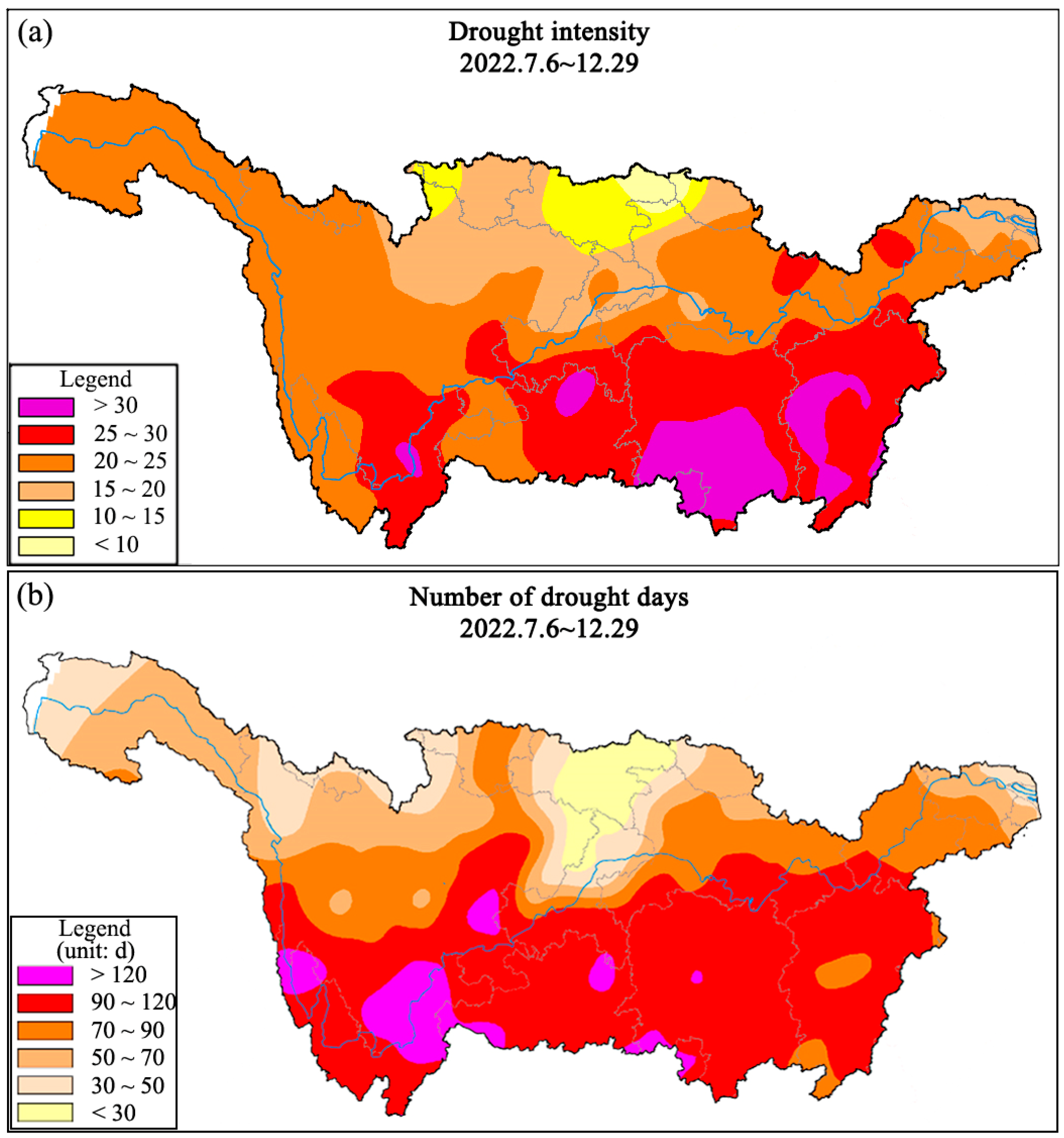
The middle and lower reaches of the Yangtze River Basin serve as a core area for advancing the development of the Yangtze River Economic Belt, boosting the rise of central China, and consolidating the “two horizontal and three vertical” urbanization strategic pattern, thus holding a pivotal strategic position. In 2022, the Yangtze River Basin suffered a basin-wide severe drought-runoff disaster, with the July–October precipitation being the lowest in the 1961–2024 period (30–90% below the multi-year normal) and the average flow of key stations (Yichang/Hankou/Datong) from June to November exceeding the 98% frequency threshold of the 1956–2024 long-term series. This posed a serious threat to the water supply security and ecological security of the mainstream in the middle and lower reaches of the Yangtze River Basin, especially in the Dongting Lake, Poyang Lake and Yangtze River Estuary, resulting in a 40% reduction in the water area of the Dongting and Poyang Lakes, a 20% decline in agricultural irrigation water supply in the middle reaches, and a disruption of migratory routes for aquatic organisms in the estuary [
1,
2]. However, due to the low frequency of similar extreme drought-runoff events in history, there are obvious deficiencies in relevant systematic research [
3,
4]. Currently, there is still no clear and unified definition of extreme drought-runoff, and the accuracy of drought-runoff event identification needs to be improved—for example, previous studies using the Standardized Streamflow Index (SSI) alone misclassified the 2011 mild drought-runoff as extreme drought due to the neglect of basin-wide hydrological coherence and seasonal runoff characteristics [
5,
6]. This situation makes it difficult to accurately grasp the evolution law and formation mechanism of extreme drought-runoff, bringing great challenges to the scientific response to such events [
7,
8].
In previous research, many scholars have proposed various meteorological and hydrological indicators from different perspectives for the identification of drought events [
9,
10,
11]. Among the existing drought identification methods, most studies focus on selecting single or multiple meteorological and hydrological indicators to describe the meteorological or hydrological process of drought events [
12,
13,
14]. However, drought does not necessarily lead to drought-runoff. Drought focuses more on the meteorological aspect, while drought-runoff pays more attention to the hydrological aspect. Thus, drought identification indicators are not necessarily applicable to drought-runoff identification [
15,
16]. The conceptual distinction between drought and drought-runoff is operationalized in
Section 3.1 through the explicit definition of drought-runoff and the establishment of hydrological frequency-based discrimination criteria for basin-wide events. Moreover, relying solely on a single indicator or a simple superposition of multiple indicators cannot fully and accurately depict the overall picture of drought-runoff events, making it difficult to clearly define the occurrence period of drought-runoff, deeply analyze its formation mechanism, and fully evaluate its multi-faceted impacts [
17,
18]. Therefore, it is urgent to further explore comprehensive identification methods for the drought-runoff events [
19].
At present, the comprehensive identification methods for drought-runoff events mainly rely on statistical methods, considering different types of indicators and realizing the coupling construction by exploring the internal connections between these indicators [
20,
21]. A multi-indicator coupling approach is necessary for drought-runoff identification because drought-runoff is a complex hydrological response to meteorological drought, which is jointly regulated by catchment hydrological storage, runoff routing, and human activities—single indicators can only capture one aspect of this process (e.g., SPI for precipitation anomalies alone and SSI for runoff deficits alone). For example, the Meteorological Drought Comprehensive Index (MCI) proposed in China National Standard “Meteorological Drought Grade” (GB/T 20481-2017) is a comprehensive index constructed by integrating multi-dimensional indicators such as 60-day precipitation, seasonal precipitation, semi-annual precipitation, and 30-day evapotranspiration [
22,
23].
Currently, the academic community has carried out extensive research on the construction, optimization, verification, and application of drought identification indicators. Researchers have focused on different hydrological elements and application scenarios, promoting the evolution of indicators from a single type to generalization and precision [
24,
25]. Runoff-related indicators are the classic core of drought identification, among which the Standardized Streamflow Index (SSI) has been widely applied due to its easy accessibility of data [
10,
26,
27]. Tijdeman (2020) clarified the impact of different calculation methods on the identification of drought characteristics by SSI through the comparison of seven probability distributions and two fitting methods, providing a key basis for the rational application of the index [
10]. To address the adaptability issue across different river types, Cammalleri (2024) proposed a unified streamflow drought index, which breaks through the limitation that traditional indicators are only applicable to specific river types through a threshold method, realizing the unified identification of drought at a global scale for both perennial and intermittent rivers [
13]. In addition to runoff indicators, the application of indicators related to precipitation, soil moisture, and other elements has been continuously deepened [
28,
29]. In a study conducted in the Tensift River Basin, Naim et al. (2025) compared and analyzed the performance of the Standardized Precipitation Index (SPI) and the Standardized Precipitation Evapotranspiration Index (SPEI), clarifying the adaptability of different indicators in regional drought identification and the optimal probability distribution model [
25]. Mohammadia et al. (2025) constructed a flash drought identification framework based on the Soil Water Deficit Index (SWDI), achieving early warning of drought events with significant agricultural impacts by capturing the rapid reduction process of plant-available water [
29]. Furthermore, the general framework for non-parametric standardized drought identification indicators constructed by Farahmand et al. (2015) has further enhanced the generality and reliability of indicator application under different regional and data conditions [
9].
In terms of research on the causes of extreme drought-runoff events, existing studies have shown that the climatic factors leading to the increased frequency of extreme drought-runoff events are mainly related to the increase in high-temperature and low-precipitation events, while human activity factors include reservoir regulation and storage, water intake and use along the river, and other aspects [
3,
30]. The climate of the Yangtze River Basin is significantly affected by monsoons [
8,
16,
31]. The basin exhibits distinct finer-scale climatic gradients: the upper reaches are dominated by alpine and subalpine climates with low annual precipitation and large diurnal temperature differences, while the middle and lower reaches are typical humid subtropical monsoon climates with concentrated summer precipitation and high annual average temperatures—this spatial climatic difference leads to heterogeneous regional hydrological responses to basin-wide drought-runoff. In summer, when the main rain belt in eastern China moves northward to North China, the basin is controlled by the Western Pacific Subtropical High, making high-temperature and low-precipitation weather prone to occur [
17,
32]. Against the background of global warming, the temporal and spatial distribution characteristics of extreme high-temperature and low-precipitation events in the Yangtze River Basin have undergone significant changes [
33,
34]. From 1961 to 2010, the number, duration, and intensity of heatwave events in the Yangtze River Basin generally showed a trend of first decreasing and then increasing [
35]. Since the 21st century, the number, intensity, and duration of heatwave events in regions such as the middle and the southeast of the Yangtze River have shown an upward trend [
36]. The increase in high-temperature and low-precipitation events is the main cause of frequent drought-runoff events in the Yangtze River Basin [
33,
37]. The 2022 extreme drought-runoff event is a typical compound climate extreme event characterized by the co-occurrence of extreme high temperature, extreme low precipitation, and their prolonged duration, which amplifies the hydrological response of the basin compared with single meteorological extreme events and is consistent with the compound extremes literature.
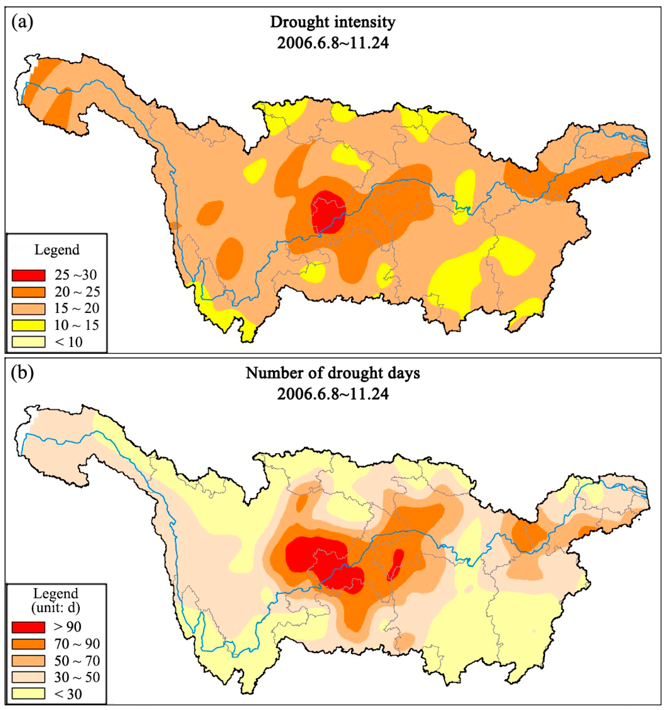
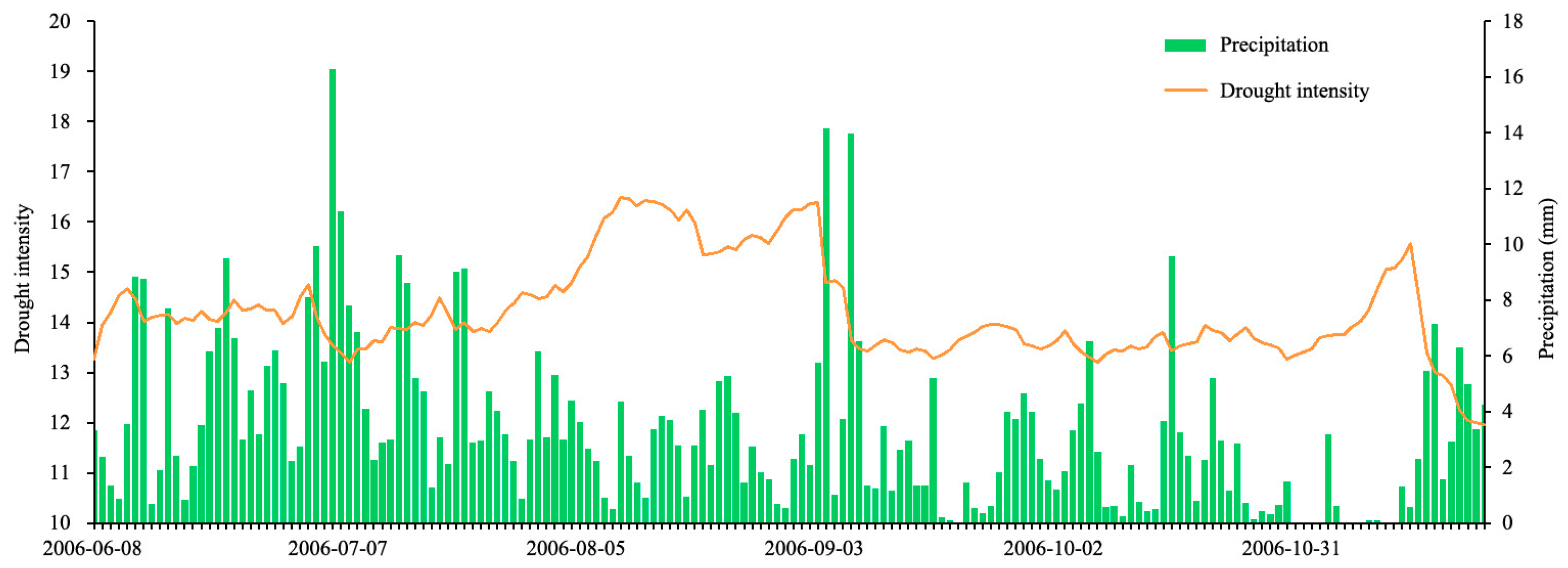
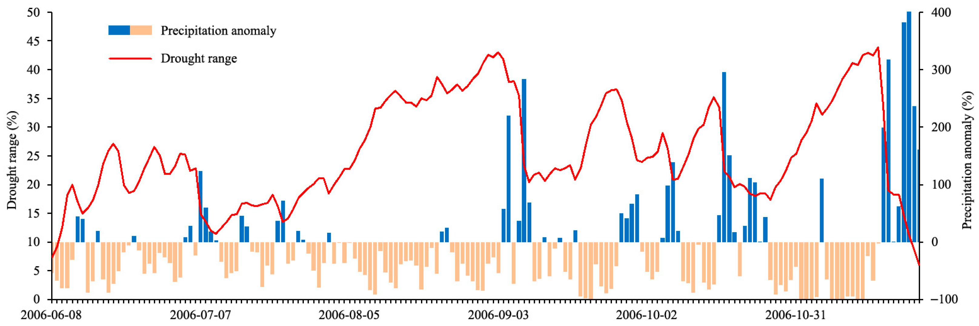
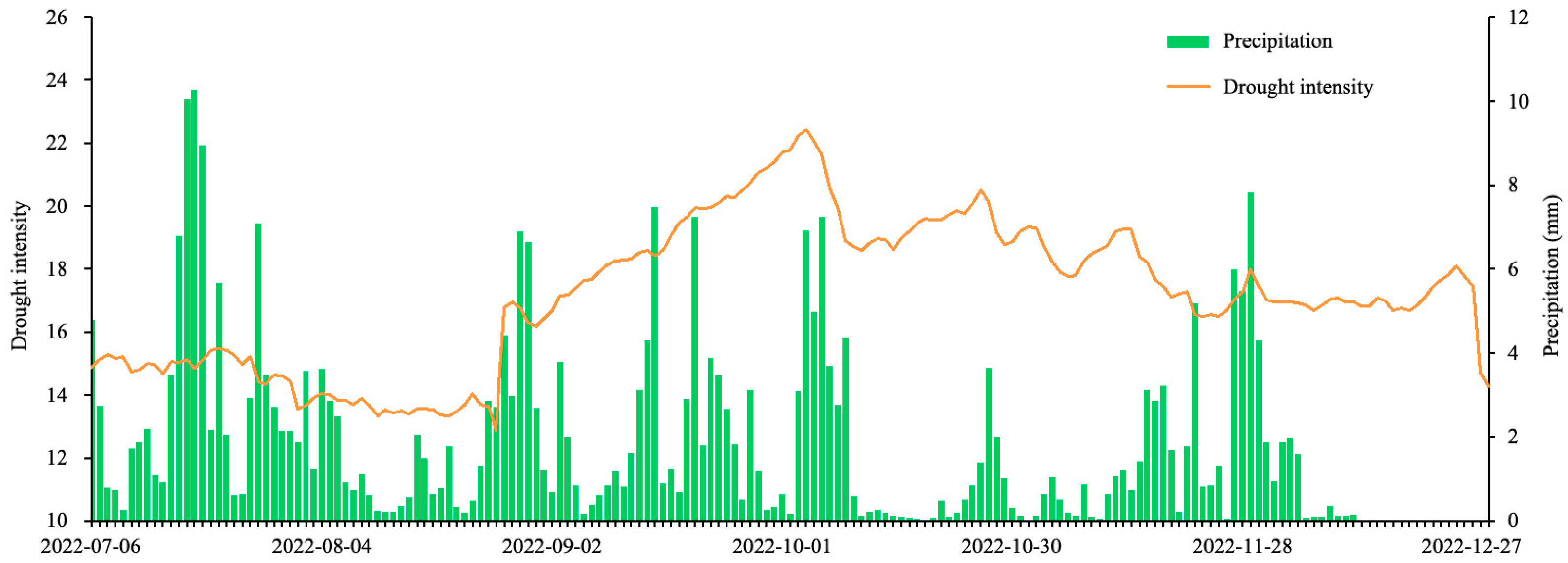
Based on the above research background, this study takes the extreme drought-runoff event in the Yangtze River Basin as the research object and focuses on exploring the identification method, analyzing the meteorological and hydrological characteristics and revealing the formation mechanism of the extreme drought-runoff event. The research methodology is explicitly mapped to the research aims: (1) Pearson-III frequency analysis (
Section 3.1) for establishing basin-wide quantitative discrimination criteria to realize accurate identification of drought-runoff events; (2) MCI analysis (
Section 3.2) for characterizing the meteorological drivers and spatiotemporal evolution of typical extreme drought-runoff events; (3) partial correlation analysis and multiple linear regression (
Section 3.3) for quantifying the contribution of different factors to drought-runoff and revealing its formation mechanism. The “basic law” in this study refers to the inherent evolution rules of drought-runoff in the Yangtze River Basin (e.g., the seasonal variation of driving factors or the hydrological response to compound meteorological extremes), which provides a theoretical basis for improving the precision of drought-runoff prediction models. Throughout this study, the aim is to provide basic law support for the development of high precision drought-runoff prediction.
5. Discussion
5.1. Advantages of the Proposed Drought-Runoff Discrimination Criteria
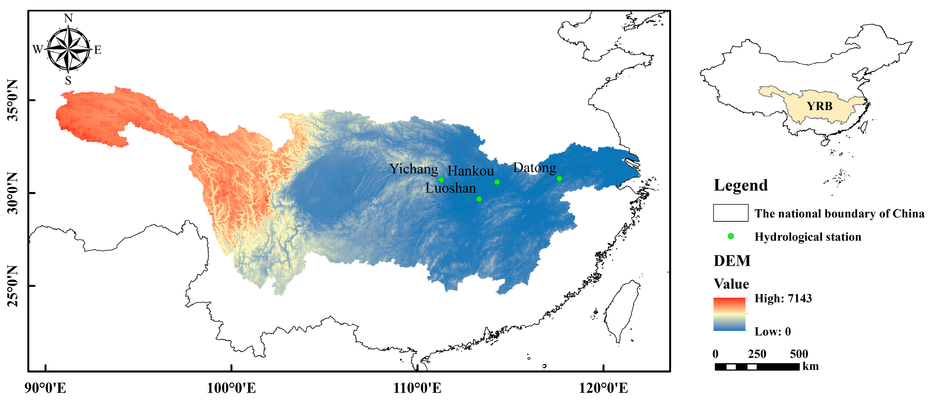
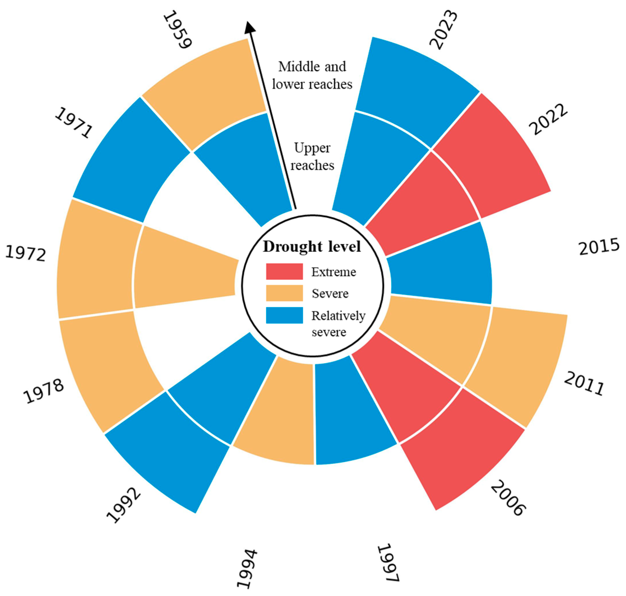
The basin-wide three-level quantitative discrimination criteria for drought-runoff proposed in this study have significant advantages compared with existing single-indicator methods (SPI/SPEI/SSI) and non-graded identification approaches. Unlike single-indicator methods that focus on local hydrological/meteorological conditions, the proposed criteria take the simultaneous flow frequency of three key mainstream stations (upper/middle/lower reaches) as the core indicator, with a temporal correlation coefficient of 0.89 (p < 0.01) and a simultaneous occurrence rate of 92% among stations—this ensures the identification of basin-wide drought-runoff events, avoiding misclassification of local droughts as basin-wide events (e.g., the 2011 local drought in the middle reach was correctly identified as severe drought-runoff rather than extreme by this study). The criteria select June-November (the main flood season and drought-runoff period of the Yangtze River Basin) as the analysis period, and define the three-level hazard standards based on Chinese hydrological practice (GB 50201-2014) and historical socio-ecological impacts—this makes the criteria more in line with the actual hydrological characteristics of the Yangtze River Basin, compared with SPI/SPEI which are based on fixed time scales (1/3/6 months) and lack seasonal targeting. The sensitivity analysis of frequency thresholds (97% vs. 98%, 94% vs. 95%, 89% vs. 90%) showed that the event classification results were completely consistent with the original thresholds; the criteria use easily accessible mainstream flow data, which can be directly applied in the operational monitoring of the Yangtze River Basin by hydrological departments, compared with complex multi-indicator coupling models that are difficult to popularize.
Table 4 shows the systematic comparison between the proposed drought-runoff discrimination criteria and four commonly used drought indices (SPI, SPEI, SSI, MCI), clarifying the added value of this study.
5.2. Comparison with Extreme Drought-Runoff Events in Other River Basins
The extreme drought-runoff events in the Yangtze River Basin (2006, 2022) have both common characteristics and unique features compared with extreme drought-runoff events in other large monsoon river basins worldwide (e.g., the Mekong, the Ganges, and the Amazon). All the extreme drought-runoff events in the monsoon river basins are dominated by meteorological factors (low precipitation + high temperature) in the flood season, with the Western Pacific Subtropical High (WPSH) and monsoon anomalies as the core large-scale circulation drivers [
46,
47]. For example, the 2019 extreme drought-runoff in the Mekong Basin was also caused by the northward shift of the WPSH and reduced monsoon precipitation, with meteorological factors contributing > 80% [
46]. Meanwhile, the Yangtze River Basin has its unique features, such as (1) Strong human intervention: The 53 key control reservoirs in the Yangtze River Basin account for 89% of the total regulation storage capacity, which can effectively offset the impact of water intake and alleviate drought-runoff. This is significantly different from the Mekong and Ganges Basins where the reservoir regulation capacity is weak (<30% of total storage) [
46,
47]; (2) Compound extreme characteristics: The 2022 event featured a unique “drought-flood abrupt alteration”, which has not been reported in other monsoon river basins in recent decades—this is related to the enhanced variability of the East Asian Monsoon under global warming; (3) Basin-wide hydrological coherence: The Yangtze River Basin has a high temporal correlation coefficient (0.89) of runoff among key stations, leading to simultaneous basin-wide drought-runoff—this is different from the Amazon Basin where hydrological heterogeneity is high, and drought-runoff events are mostly local [
48].
5.3. Scientific and Policy Implications of This Study
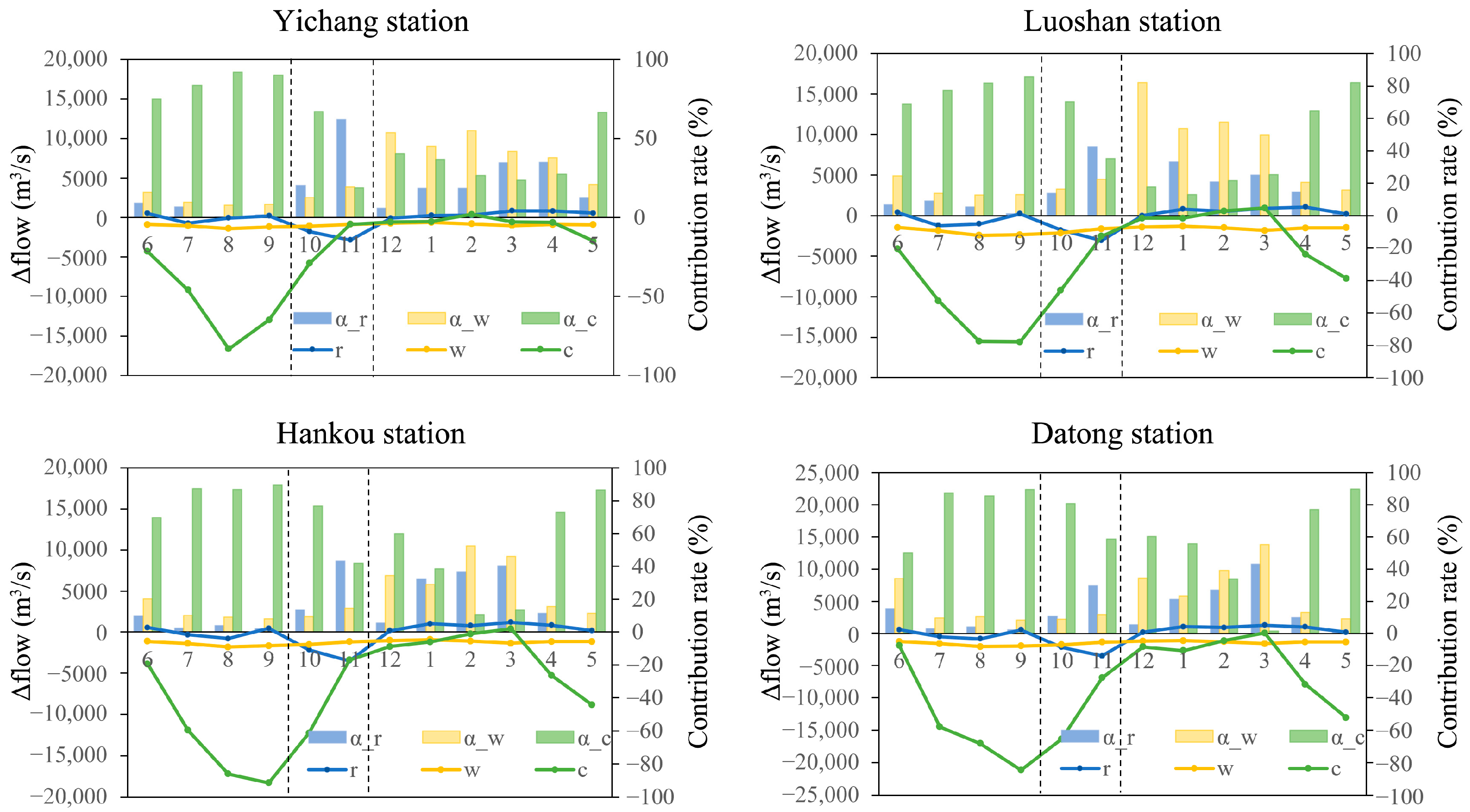
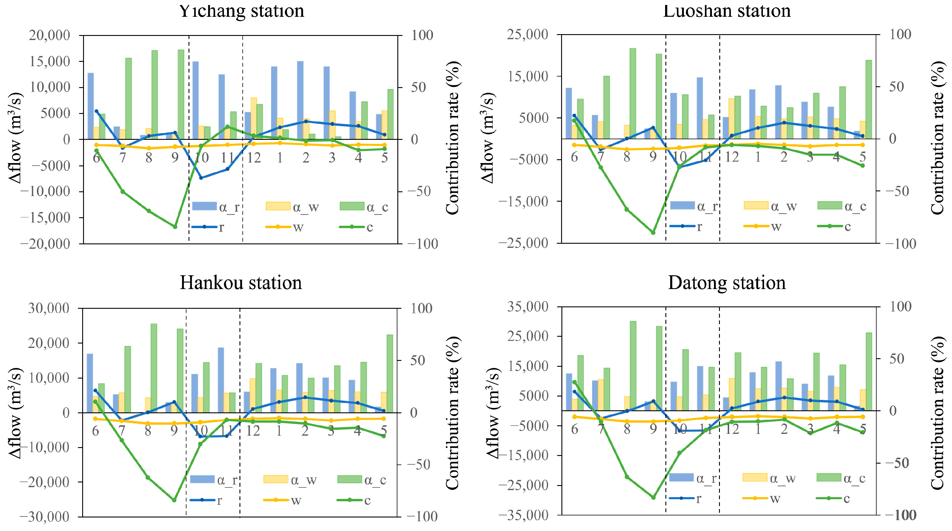
This study quantified the seasonal variation of the contribution of meteorological factors, the reservoir operation, and the water intake to drought-runoff, and found that the reservoir operation can transform from a drought-runoff driver (flood season storage) to a mitigation factor (non-flood season supplementation)—this enriches the theoretical understanding of hydrological drought evolution under intense human activities in large river basins. The 2022 event was identified as a typical compound extreme event (extreme low precipitation + extreme high temperature + prolonged duration), which amplifies the hydrological response of the basin—this provides a new perspective for the study of drought-runoff in the context of global warming, i.e., paying attention to the combined impact of multiple meteorological extremes rather than to a single factor. The proposed basin-wide drought-runoff analysis framework (discrimination criteria + multi-factor attribution) can be applied to other large monsoon river basins with significant human intervention (e.g., the Mekong, the Ganges) by adjusting the frequency thresholds and key stations according to local hydrological characteristics—this improves the generality of the research results.
Based on the study results, the reservoir joint dispatch rules of the Yangtze River Basin should be optimized—increase water storage in the early flood season (June) when the precipitation is sufficient and increase water supplementation in the late flood season (September) and non-flood season (Dec–May) to offset the meteorological and water intake impacts. For example, the reservoir group can increase the water supplement by 500–1000 m3/s in September to further alleviate the peak drought-runoff. The proposed three-level discrimination criteria can be integrated into the existing drought early warning system of the Yangtze River Basin, with the 90%/95%/98% flow frequency as the early warning thresholds for relatively severe/severe/extreme drought-runoff—this improves the precision and operability of early warning. Aiming at the different characteristics of drought-runoff in different periods, targeted adaptation strategies should be formulated: (1) Flood season (Jun–Sep). Focus on mitigating the impact of meteorological factors, such as optimizing agricultural irrigation schedules to reduce water use; (2) Post-flood season (Oct–Nov). Focus on coordinating reservoir storage and water supply, avoiding excessive storage leading to aggravated drought-runoff; (3) Non-flood season (Dec–May). Focus on maximizing reservoir water supplementation to ensure basic water supply and ecological flow. The proposed criteria and dispatch strategies can be applied to other monsoon river basins (e.g., the Mekong) by adjusting the local parameters—this provides a reference for the global response to hydrological drought in large river basins under the background of climate change and human activities.
5.4. Study Limitations
This study focuses on basin-wide drought-runoff events and selects only mainstream key stations, ignoring the hydrological heterogeneity of tributaries (e.g., Han River, Jialing River)—tributary drought-runoff may have a local impact on water supply and ecology, which needs to be studied in depth. Moreover, the discrimination criteria proposed in this study are only applicable to the summer–autumn drought-runoff (June–November) of the Yangtze River Basin, and cannot identify the spring drought-runoff (January–May)—subsequent research needs to establish spring drought-runoff discrimination criteria based on seasonal hydrological characteristics.
5.5. External Validation
To verify the rationality and applicability of the proposed drought-runoff discrimination criteria, external validation was conducted by correlating the identified drought-runoff years with documented socio-ecological impact records (agricultural losses, water supply disruptions, and ecological impacts) of the Yangtze River Basin from 1956 to 2024.
The identified extreme drought-runoff years (2006, 2022) had the most severe agricultural losses in the study period—2006 caused a 15% reduction in grain production in the middle and lower reaches, and 2022 caused a 20% reduction (vs. multi-year average); severe drought-runoff years (1972, 2011) caused a 8–12% reduction in grain production; relatively severe drought-runoff years (1959, 1992, 2024) caused a 3–5% reduction—the loss degree is positively correlated with the drought-runoff severity level identified by the criteria (correlation coefficient = 0.92, p < 0.01).
Extreme drought-runoff years (2006, 2022) caused water supply disruptions in 23 and 31 cities in the basin, respectively; severe drought-runoff years (1972, 2011) caused disruptions in 12 and 15 cities; relatively severe drought-runoff years caused disruptions in three to five cities—the number of water supply disruptions is consistent with the drought-runoff severity level.
Extreme drought-runoff years (2006, 2022) led to a 40% and a 50% reduction in the water area of Dongting/Poyang Lakes, respectively, and a significant decline in aquatic organism diversity (30% and 35% reduction in fish species); severe drought-runoff years led to a 20–25% reduction in lake water area; relatively severe drought-runoff years led to a <10% reduction—the ecological impact degree is positively correlated with the drought-runoff severity level.
The external validation results show that the drought-runoff severity level identified by the proposed criteria is highly consistent with the actual socio-ecological impact records of the Yangtze River Basin, which verifies the rationality, reliability and applicability of the criteria.